INTRODUCTION
Background: Bantu-speaking people settled in the area now called Angola in 6th century A.D.; by the 10th century various Bantu groups had established kingdoms, of which Kongo became the most powerful. From the late 14th to the mid 19th century a Kingdom of Kongo stretched across central Africa from present-day northern Angola into the current Congo republics. It traded heavily with the Portuguese who, beginning in the 16th century, established coastal colonies and trading posts and introduced Christianity. Angola became a major hub of the transatlantic slave trade conducted by the Portuguese and other European powers - often in collaboration with local kingdoms including the Kongo. Estimates are that the Angola area may have lost as many as 4 million people as a result of the slave trade. The Kingdom of Kongo’s main rival was the Kingdom of Ndongo to its south, whose most famous leader was the 17th century diplomat to the Portuguese and later Queen, Nzingha Mbande, who successfully fought off Portuguese encroachment during her nearly 40-year reign. Smaller kingdoms, such as the Matamba and Ngoyo, often came under the control of the Kongo or Ndongo Kingdoms. During the Berlin Conference of 1884-85, Angola’s modern borders were set by Portugal and other European powers, but the Portuguese did not fully control of large portions of the territory. Portugal gained control of the Kingdom of Kongo in 1888 when Kongo’s King Pedro V sought Portuguese military assistance in exchange for becoming a vassal. After a revolt in 1914, Portugal imposed direct rule over the colony and abolished the Kongo Kingdom.
The Angolan National Revolution began in 1961 and in 1975, Angola won its independence when Portugal’s dictatorship fell, in part because of growing discontent over conflict in Angola and other colonies. Conflict between Angola’s multiple independence movements quickly emerged with the Popular Movement for Liberation of Angola (MPLA), led by Agostinho NETO, taking power and the National Union for the Total Independence of Angola (UNITA), led by Jonas SAVIMBI, emerging as its main competitor. After NETO’s death in 1979, Jose Eduardo DOS SANTOS, also of the MPLA, became president. Over time, the Angolan civil war escalated and became a major Cold War conflict with the MPLA supported by the Soviet Union and Cuba and UNITA by apartheid South Africa and the US. Up to 1.5 million lives may have been lost - and 4 million people displaced - during the more than a quarter century of fighting. SAVIMBI’s death in 2002 ended UNITA’s insurgency and cemented the MPLA’s hold on power. DOS SANTOS did not seek reelection in 2017 and supported Joao LOURENCO’s successful bid to become president. LOURENCO was reelected in 2022. Angola scores low on human development indexes despite using its large oil reserves to rebuild since the end of a 27-year civil war in 2002.
GEOGRAPHY
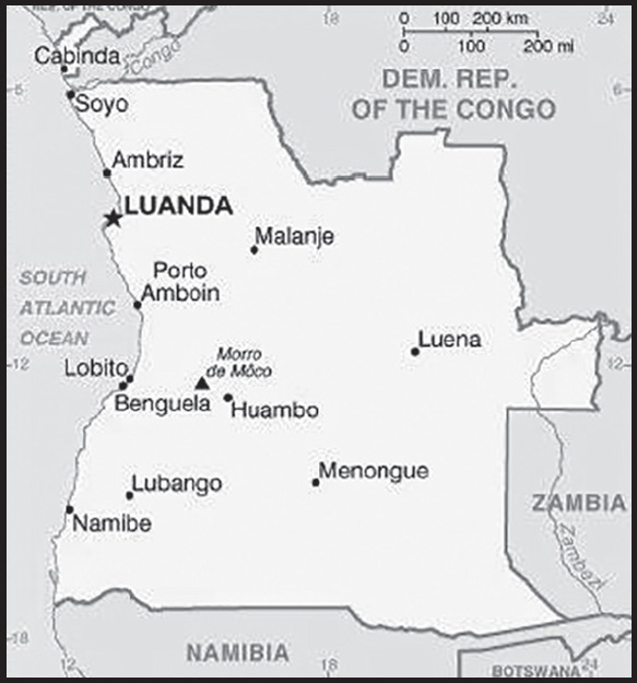
Location: Southern Africa, bordering the South Atlantic Ocean, between Namibia and Democratic Republic of the Congo
Geographic coordinates: 12 30 S, 18 30 E
Map references: Africa
Area: total: 1,246,700 sq km
land: 1,246,700 sq km
water: 0 sq km
comparison ranking: total 24
Area - comparative: about eight times the size of Georgia; slightly less than twice the size of Texas
Land boundaries: total: 5,369 km
border countries (4): Democratic Republic of the Congo 2,646 km (of which 225 km is the boundary of discontiguous Cabinda Province); Republic of the Congo 231 km; Namibia 1,427 km; Zambia 1,065 km
Coastline: 1,600 km
Maritime claims: territorial sea: 12 nm
contiguous zone: 24 nm
exclusive economic zone: 200 nm
Climate: semiarid in south and along coast to Luanda; north has cool, dry season (May to October) and hot, rainy season (November to April)
Terrain: narrow coastal plain rises abruptly to vast interior plateau
Elevation: highest point: Moca 2,620 m
lowest point: Atlantic Ocean 0 m
mean elevation: 1,112 m
Natural resources: petroleum, diamonds, iron ore, phosphates, copper, feldspar, gold, bauxite, uranium
Land use: agricultural land: 45.7% (2018 est.)
arable land: 3.9% (2018 est.)
permanent crops: 0.3% (2018 est.)
permanent pasture: 41.5% (2018 est.)
forest: 54.3% (2018 est.)
Irrigated land: 860 sq km (2014)
Major rivers (by length in km): Rio Zambeze (Zambezi) (shared with Zambia [s], Namibia, Botswana, Zimbabwe, and Mozambique [m]) - 2,740 km; Rio Cubango (Okavango) river source (shared with Namibia and Botswana [m]) - 1,600 km
note – [s] after country name indicates river source; [m] after country name indicates river mouth
Major watersheds (area sq km):
Atlantic Ocean drainage: Congo (3,730,881 sq km)
Indian Ocean drainage: Zambezi (1,332,412 sq km)
Internal (endorheic basin) drainage: Okavango Basin (863,866 sq km)
Major aquifers: Congo Basin, Upper Kalahari-Cuvelai-Upper Zambezi Basin
Population distribution: most people live in the western half of the country; urban areas account for the highest concentrations of people, particularly the capital of Luanda as shown in this population distribution map
Natural hazards: locally heavy rainfall causes periodic flooding on the plateau
Geography - note: the province of Cabinda is an exclave, separated from the rest of the country by the Democratic Republic of the Congo
PEOPLE AND SOCIETY
Population: 35,981,281 (2023 est.)
comparison ranking: 4
Nationality: noun: Angolan(s)
adjective: Angolan
Ethnic groups: Ovimbundu 37%, Kimbundu 25%, Bakongo 13%, Mestico (mixed European and native African) 2%, European 1%, other 22%
Languages: Portuguese 71.2% (official), Umbundu 23%, Kikongo 8.2%, Kimbundu 7.8%, Chokwe 6.5%, Nhaneca 3.4%, Nganguela 3.1%, Fiote 2.4%, Kwanhama 2.3%, Muhumbi 2.1%, Luvale 1%, other 3.6%; note - data represent most widely spoken languages; shares sum to more than 100% because some respondents gave more than one answer on the census (2014 est.)
Religions: Roman Catholic 41.1%, Protestant 38.1%, other 8.6%, none 12.3% (2014 est.)
Demographic profile: More than two decades after the end of Angola’s 27-year civil war, the country still faces a variety of socioeconomic problems, including poverty, high maternal and child mortality, and illiteracy. Despite the country’s rapid post-war economic growth based on oil production, about 30 percent of Angolans live below the poverty line and unemployment is widespread, especially among the large young-adult population. Only about 70% of the population is literate, and the rate drops to around 60% for women. The youthful population - about 48% are under the age of 15 as of 2022 - is expected to continue growing rapidly with a fertility rate of more than 5 children per woman and a low rate of contraceptive use. Fewer than half of women deliver their babies with the assistance of trained health care personnel, which contributes to Angola’s high maternal mortality rate.
Of the estimated 550,000 Angolans who fled their homeland during its civil war, most have returned home since 2002. In 2012, the UN assessed that conditions in Angola had been stable for several years and invoked a cessation of refugee status for Angolans.
Following the cessation clause, some of those still in exile returned home voluntarily through UN repatriation programs, and others integrated into host countries.
Age structure: 0-14 years: 47.18% (male 8,503,242/female 8,473,889)
15-64 years: 50.49% (male 8,730,015/female 9,435,581)
65 years and over: 2.33% (2023 est.) (male 350,059/female 488,495)
Dependency ratios: total dependency ratio: 91.5
youth dependency ratio: 86.5
elderly dependency ratio: 5
potential support ratio: 20.1 (2021 est.)
Median age: total: 15.9 years (2020)
male: 15.4 years
female: 16.4 years
comparison ranking: total 225
Population growth rate: 3.34% (2023 est.)
comparison ranking: 6
Birth rate: 41.42 births/1,000 population (2023 est.)
comparison ranking: 2
Death rate: 7.8 deaths/1,000 population (2023 est.)
comparison ranking: 98
Net migration rate: -0.19 migrant(s)/1,000 population (2023 est.)
comparison ranking: 110
Population distribution: most people live in the western half of the country; urban areas account for the highest concentrations of people, particularly the capital of Luanda as shown in this population distribution map
Urbanization: urban population: 68.7% of total population (2023)
rate of urbanization: 4.04% annual rate of change (2020-25 est.)
Major urban areas - population: 9.292 million LUANDA (capital), 959,000 Lubango, 905,000 Cabinda, 809,000 Benguela, 783,000 Malanje (2023)
Sex ratio: at birth: 1.03 male(s)/female
0-14 years: 1 male(s)/female
15-64 years: 0.93 male(s)/female
65 years and over: 0.72 male(s)/female
total population: 0.96 male(s)/female (2023 est.)
Mother’s mean age at first birth: 19.4 years (2015/16 est.)
note: data represents median age at first birth among women 20-49
Maternal mortality ratio: 222 deaths/100,000 live births (2020 est.)
comparison ranking: 41
Infant mortality rate: total: 57.2 deaths/1,000 live births (2023 est.)
male: 62.37 deaths/1,000 live births
female: 51.87 deaths/1,000 live births
comparison ranking: total 12
Life expectancy at birth: total population: 62.51 years (2023 est.)
male: 60.44 years
female: 64.65 years
comparison ranking: total population 215
Total fertility rate: 5.76 children born/woman (2023 est.)
comparison ranking: 2
Gross reproduction rate: 2.84 (2023 est.)
Contraceptive prevalence rate: 13.7% (2015/16)
Drinking water source: improved: urban: 81.3% of population
rural: 36.5% of population
total: 66.5% of population
unimproved: urban: 18.7% of population
rural: 63.5% of population
total: 33.5% of population (2020 est.)
Current health expenditure: 2.9% of GDP (2020)
Physicians density: 0.21 physicians/1,000 population (2018)
Sanitation facility access: improved: urban: 93.7% of population
rural: 30.3% of population
total: 72.7% of population
unimproved: urban: 6.3% of population
rural: 69.7% of population
total: 27.3% of population (2020 est.)
Major infectious diseases: degree of risk: very high (2023)
food or waterborne diseases: bacterial and protozoal diarrhea, hepatitis A, typhoid fever
vectorborne diseases: dengue fever, malaria
water contact diseases: schistosomiasis
animal contact diseases: rabies
Obesity - adult prevalence rate: 8.2% (2016)
comparison ranking: 154
Alcohol consumption per capita: total: 5.84 liters of pure alcohol (2019 est.)
beer: 3.78 liters of pure alcohol (2019 est.)
wine: 0.72 liters of pure alcohol (2019 est.)
spirits: 1.27 liters of pure alcohol (2019 est.)
other alcohols: 0.08 liters of pure alcohol (2019 est.)
comparison ranking: total 73
Children under the age of 5 years underweight: 19% (2015/16)
comparison ranking: 20
Currently married women (ages 15-49): 55.7% (2023 est.)
Child marriage: women married by age 15: 7.9%
women married by age 18: 30.3%
men married by age 18: 6% (2016 est.)
Education expenditures: 2.4% of GDP (2020 est.)
comparison ranking: 178
Literacy: definition: age 15 and over can read and write
total population: 71.1%
male: 82.6%
female: 62.4% (2015)
Youth unemployment rate (ages 15-24): total: 18.5% (2021 est.)
male: 18.2%
female: 18.8%
comparison ranking: total 91
ENVIRONMENT
Environment - current issues: overuse of pastures and subsequent soil erosion attributable to population pressures; desertification; deforestation of tropical rain forest, in response to both international demand for tropical timber and to domestic use as fuel, resulting in loss of biodiversity; soil erosion contributing to water pollution and siltation of rivers and dams; inadequate supplies of potable water
Environment - international agreements: party to: Biodiversity, Climate Change, Climate Change-Kyoto Protocol, Climate Change-Paris Agreement, Comprehensive Nuclear Test Ban, Desertification, Endangered Species, Hazardous Wastes, Law of the Sea, Marine Dumping-London Protocol, Ozone Layer Protection, Ship Pollution
signed, but not ratified: none of the selected agreements
Climate: semiarid in south and along coast to Luanda; north has cool, dry season (May to October) and hot, rainy season (November to April)
Land use: agricultural land: 45.7% (2018 est.)
arable land: 3.9% (2018 est.)
permanent crops: 0.3% (2018 est.)
permanent pasture: 41.5% (2018 est.)
forest: 54.3% (2018 est.)
Urbanization: urban population: 68.7% of total population (2023)
rate of urbanization: 4.04% annual rate of change (2020-25 est.)
Revenue from forest resources: 0.36% of GDP (2018 est.)
comparison ranking: 75
Revenue from coal: 0% of GDP (2018 est.)
comparison ranking: 75
Air pollutants: particulate matter emissions: 27.16 micrograms per cubic meter (2019 est.)
carbon dioxide emissions: 34.69 megatons (2016 est.)
methane emissions: 23.28 megatons (2020 est.)
Waste and recycling: municipal solid waste generated annually: 4,213,644 tons (2012 est.)
Major rivers (by length in km): Rio Zambeze (Zambezi) (shared with Zambia [s], Namibia, Botswana, Zimbabwe, and Mozambique [m]) - 2,740 km; Rio Cubango (Okavango) river source (shared with Namibia and Botswana [m]) - 1,600 km
note – [s] after country name indicates river source; [m] after country name indicates river mouth
Major watersheds (area sq km):
Atlantic Ocean drainage: Congo (3,730,881 sq km)
Indian Ocean drainage: Zambezi (1,332,412 sq km)
Internal (endorheic basin) drainage: Okavango Basin (863,866 sq km)
Major aquifers: Congo Basin, Upper Kalahari-Cuvelai-Upper Zambezi Basin
Total water withdrawal: municipal: 320 million cubic meters (2020 est.)
industrial: 240 million cubic meters (2020 est.)
agricultural: 150 million cubic meters (2020 est.)
Total renewable water resources: 148.4 billion cubic meters (2020 est.)
GOVERNMENT
Country name: conventional long form: Republic of Angola
conventional short form: Angola
local long form: Republica de Angola
local short form: Angola
former: People’s Republic of Angola
etymology: name derived by the Portuguese from the title “ngola” held by kings of the Ndongo (Ndongo was a kingdom in what is now Angola)
Government type: presidential republic
Capital: name: Luanda
geographic coordinates: 8 50 S, 13 13 E
time difference: UTC+1 (6 hours ahead of Washington, DC, during Standard Time)
daylight saving time: does not observe daylight savings time
etymology: originally named “Sao Paulo da Assuncao de Loanda” (Saint Paul of the Assumption of Loanda), which over time was shortened and corrupted to just Luanda
Administrative divisions: 18 provinces (provincias, singular - provincia); Bengo, Benguela, Bie, Cabinda, Cuando Cubango, Cuanza-Norte, Cuanza-Sul, Cunene, Huambo, Huila, Luanda, Lunda-Norte, Lunda-Sul, Malanje, Moxico, Namibe, Uige, Zaire
Independence: 11 November 1975 (from Portugal)
National holiday: Independence Day, 11 November (1975)
Constitution: history: previous 1975, 1992; latest passed by National Assembly 21 January 2010, adopted 5 February 2010
amendments: proposed by the president of the republic or supported by at least one third of the National Assembly membership; passage requires at least two-thirds majority vote of the Assembly subject to prior Constitutional Court review if requested by the president of the republic
Legal system: civil legal system based on Portuguese civil law; no judicial review of legislation
International law organization participation: has not submitted an ICJ jurisdiction declaration; non-party state to the ICCt
Citizenship: citizenship by birth: no
citizenship by descent only: at least one parent must be a citizen of Angola
dual citizenship recognized: no
residency requirement for naturalization: 10 years
Suffrage: 18 years of age; universal
Executive branch: chief of state: President Joao Manuel Goncalves LOURENCO (since 15 September 2022); Vice President Esperanca Francisco DA COSTA (since 15 September 2022); note - the president is both chief of state and head of government
head of government: President Joao Manuel Goncalves LOURENCO (since 15 September 2022); Vice President Esperanca Francisco DA COSTA (since 15 September 2022)
cabinet: Council of Ministers appointed by the president
elections/appointments: the candidate of the winning party or coalition in the last legislative election becomes the president; president serves a 5-year term (eligible for a second consecutive or discontinuous term); last held on 24 August 2022 (next to be held in 2027)
election results: Joao Manuel Goncalves LOURENCO (MPLA) elected president by then winning party following the 24 August 2022 general election
Legislative branch: description: unicameral National Assembly or Assembleia Nacional (220 seats; members directly elected in a single national constituency and in multi-seat constituencies by closed list proportional representation vote; members serve 5-year terms)
elections: last held on 24 August 2022 (next to be held in 2027)
election results: percent of vote by party - MPLA 51.1%, UNITA 43.9%, FNLA 1.1%, PHA 1%, PRS 1.1%, other 1.7%; seats by party - MPLA 124, UNITA 90, FNLA 2, PHA 2, PRS 2; composition - men 146, women 74, percent of women 33.6%
Judicial branch: highest court(s): Supreme Court or Supremo Tribunal de Justica (consists of the court president, vice president, and a minimum of 16 judges); Constitutional Court or Tribunal Constitucional (consists of 11 judges)
judge selection and term of office: Supreme Court judges appointed by the president upon recommendation of the Supreme Judicial Council, an 18-member body chaired by the president; judge tenure NA; Constitutional Court judges - 4 nominated by the president, 4 elected by National Assembly, 2 elected by Supreme National Council, 1 elected by competitive submission of curricula; judges serve single 7-year terms
subordinate courts: provincial and municipal courts
Political parties and leaders: Broad Convergence for the Salvation of Angola Electoral Coalition or CASA-CE [Manuel FERNANDES]
National Front for the Liberation of Angola or FNLA; note - party has two factions; one led by Lucas NGONDA; the other by Ngola KABANGU
National Union for the Total Independence of Angola or UNITA [Adalberto Costa JUNIOR] (largest opposition party) Popular Movement for the Liberation of Angola or MPLA [Joao LOURENCO]; note- ruling party in power since 1975 Social Renewal Party or PRS [Benedito DANIEL]
International organization participation: ACP, AfDB, AU, CEMAC, CPLP, FAO, G-77, IAEA, IBRD, ICAO, ICRM, IDA, IFAD, IFC, IFRCS, ILO, IMF, IMO, Interpol, IOC, IOM, IPU, ISO (correspondent), ITSO, ITU, ITUC (NGOs), MIGA, NAM, OAS (observer), OPEC, SADC, UN, UNCTAD, UNESCO, UNIDO, UNMISS, Union Latina, UNWTO, UPU, WCO, WFTU (NGOs), WHO, WIPO, WMO, WTO
Diplomatic representation in the US: chief of mission: Ambassador Agostinho de Carvalho dos Santos VAN-DÚNEM (since 30 June 2023)
chancery: 2108 16th Street NW, Washington, DC 20009
telephone: [1] (202) 785-1156
FAX: [1] (202) 822-9049
email address and website: info@angola.org
consulate(s) general: Houston, New York
Diplomatic representation from the US: chief of mission: Ambassador Tulinabo S. MUSHINGI, (since 9 March 2022)
embassy: Rua Houari Boumedienne, #32, Luanda
mailing address: 2550 Luanda Place, Washington, DC 20521-2550
telephone: [244] (222) 64-1000
FAX: [244] (222) 64-1000
email address and website: Consularluanda@state.gov
Flag description: two equal horizontal bands of red (top) and black with a centered yellow emblem consisting of a five-pointed star within half a cogwheel crossed by a machete (in the style of a hammer and sickle); red represents liberty and black the African continent; the symbols characterize workers and peasants
National symbol(s): Palanca Negra Gigante (giant black sable antelope); national colors: red, black, yellow
National anthem: name: “Angola Avante” (Forward Angola)
lyrics/music: Manuel Rui Alves MONTEIRO/Rui Alberto Vieira Dias MINGAO
note: adopted 1975
National heritage: total World Heritage Sites: 1 (cultural)
selected World Heritage Site locales: Mbanza-Kongo
ECONOMY
Economic overview: African oil leader and OPEC member; fairly stable currency; widespread poverty; emerging African finance and investment capital; systemic public corruption and lack of oversight; massive foreign direct investment recipient
Real GDP (purchasing power parity): $203.868 billion (2021 est.)
$201.65 billion (2020 est.)
$213.612 billion (2019 est.)
note: data are in 2017 dollars
comparison ranking: 67
Real GDP growth rate: 1.1% (2021 est.)
-5.6% (2020 est.)
-0.7% (2019 est.)
comparison ranking: 182
Real GDP per capita: $5,900 (2021 est.)
$6,000 (2020 est.)
$6,600 (2019 est.)
note: data are in 2017 dollars
comparison ranking: 165
GDP (official exchange rate): $97.261 billion (2019 est.)
Inflation rate (consumer prices): 25.75% (2021 est.)
22.27% (2020 est.)
17.08% (2019 est.)
comparison ranking: 11
Credit ratings: Fitch rating: CCC (2020)
Moody’s rating: Caa1 (2020)
Standard & Poors rating: CCC+ (2020)
note: The year refers to the year in which the current credit rating was first obtained.
GDP - composition, by sector of origin: agriculture: 10.2% (2011 est.)
industry: 61.4% (2011 est.)
services: 28.4% (2011 est.)
comparison rankings: services 225; industry 1; agriculture 89
GDP - composition, by end use: household consumption: 80.6% (2017 est.)
government consumption: 15.6% (2017 est.)
investment in fixed capital: 10.3% (2017 est.)
investment in inventories: -1.2% (2017 est.)
exports of goods and services: 25.4% (2017 est.)
imports of goods and services: -30.7% (2017 est.)
Agricultural products: cassava, bananas, maize, sweet potatoes, pineapples, sugar cane, potatoes, citrus fruit, vegetables, cabbage
Industries: petroleum; diamonds, iron ore, phosphates, feldspar, bauxite, uranium, and gold; cement; basic metal products; fish processing; food processing, brewing, tobacco products, sugar; textiles; ship repair
Industrial production growth rate: -8.34% (2021 est.)
comparison ranking: 198
Labor force: 14.462 million (2021 est.)
comparison ranking: 42
Labor force - by occupation: agriculture: 85%
industry: 15% (2015 est.)
industry and services: 15% (2003 est.)
Unemployment rate: 8.53% (2021 est.)
8.33% (2020 est.)
7.42% (2019 est.)
comparison ranking: 87
Youth unemployment rate (ages 15-24): total: 18.5% (2021 est.)
male: 18.2%
female: 18.8%
comparison ranking: total 91
Population below poverty line: 32.3% (2018 est.)
Gini Index coefficient - distribution of family income: 51.3 (2018 est.)
comparison ranking: 10
Average household expenditures: on food: 48.6% of household expenditures (2018 est.)
on alcohol and tobacco: 1.5% of household expenditures (2018 est.)
Household income or consumption by percentage share: lowest 10%: 0.6%
highest 10%: 44.7% (2000)
Budget: revenues: $17.899 billion (2019 est.)
expenditures: $17.244 billion (2019 est.)
Budget surplus (+) or deficit (-): -6.7% (of GDP) (2017 est.)
comparison ranking: 189
Public debt: 65% of GDP (2017 est.)
75.3% of GDP (2016 est.)
comparison ranking: 68
Taxes and other revenues: 10.09% (of GDP) (2019 est.)
comparison ranking: 191
Fiscal year: calendar year
Current account balance: $8.399 billion (2021 est.)
$871.918 million (2020 est.)
$5.137 billion (2019 est.)
comparison ranking: 28
Exports: $33.675 billion (2021 est.)
$21.004 billion (2020 est.)
$35.18 billion (2019 est.)
note: Data are in current year dollars and do not include illicit exports or re-exports.
comparison ranking: 73
Exports - partners: China 62%, India 10%, United Arab Emirates 4%, Portugal 3%, Spain 3% (2019)
Exports - commodities: crude petroleum, natural gas, diamonds, refined petroleum, asphalt mixtures (2021)
Imports: $18.845 billion (2021 est.) note: data are in current year dollars
$15.146 billion (2020 est.) note: data are in current year dollars
$22.299 billion (2019 est.) note: data are in current year dollars
comparison ranking: 92
Imports - partners: China 22%, Portugal 15%, Nigeria 6%, Belgium 6%, United States 5%, South Africa 5%, Brazil 5% (2019)
Imports - commodities: refined petroleum, scrap vessels, meat, rice, palm oil (2019)
Reserves of foreign exchange and gold: $14.468 billion (31 December 2021 est.)
$13.782 billion (31 December 2020 est.)
$16.335 billion (31 December 2019 est.)
comparison ranking: 73
Debt - external: $42.08 billion (31 December 2017 est.)
$27.14 billion (31 December 2016 est.)
comparison ranking: 74
Exchange rates: kwanza (AOA) per US dollar -
Exchange rates: 631.442 (2021 est.)
578.259 (2020 est.)
364.826 (2019 est.)
252.856 (2018 est.)
165.916 (2017 est.)
ENERGY
Electricity access: population without electricity: 18 million (2020)
electrification - total population: 48.2% (2021)
electrification - urban areas: 74.9% (2021)
electrification - rural areas: 7.3% (2018)
Electricity: installed generating capacity: 7.344 million kW (2020 est.)
consumption: 11.815 billion kWh (2019 est.)
exports: 0 kWh (2019 est.)
imports: 0 kWh (2019 est.)
transmission/distribution losses: 1.741 billion kWh (2019 est.)
comparison rankings installed generating capacity 76; transmission/distribution losses 92; imports 141; exports 124; consumption 93
Electricity generation sources: fossil fuels: 28.4% of total installed capacity (2020 est.)
nuclear: 0% of total installed capacity (2020 est.)
solar: 0.1% of total installed capacity (2020 est.)
wind: 0% of total installed capacity (2020 est.)
hydroelectricity: 70.1% of total installed capacity (2020 est.)
tide and wave: 0% of total installed capacity (2020 est.)
geothermal: 0% of total installed capacity (2020 est.)
biomass and waste: 1.4% of total installed capacity (2020 est.)
Coal: production: 0 metric tons (2020 est.)
consumption: 0 metric tons (2020 est.)
exports: 0 metric tons (2020 est.)
imports: 0 metric tons (2020 est.)
proven reserves: 0 metric tons (2019 est.)
Petroleum: total petroleum production: 1,197,600 bbl/day (2021 est.)
refined petroleum consumption: 133,400 bbl/day (2019 est.)
crude oil and lease condensate exports: 1,367,400 bbl/day (2018 est.)
crude oil and lease condensate imports: 0 bbl/day (2018 est.)
crude oil estimated reserves: 7.783 billion barrels (2021 est.)
Refined petroleum products - production: 53,480 bbl/day (2015 est.)
comparison ranking: 80
Refined petroleum products - exports: 30,340 bbl/day (2015 est.)
comparison ranking: 62
Refined petroleum products - imports: 111,600 bbl/day (2015 est.)
comparison ranking: 50
Natural gas: production: 6,767,715,000 cubic meters (2019 est.)
consumption: 860.887 million cubic meters (2019 est.)
exports: 5,877,945,000 cubic meters (2019 est.)
imports: 0 cubic meters (2021 est.)
proven reserves: 343.001 billion cubic meters (2021 est.)
Carbon dioxide emissions: 19.362 million metric tonnes of CO2 (2019 est.)
from coal and metallurgical coke: 0 metric tonnes of CO2 (2019 est.)
from petroleum and other liquids: 17.673 million metric tonnes of CO2 (2019 est.)
from consumed natural gas: 1.689 million metric tonnes of CO2 (2019 est.)
comparison ranking: total emissions 84
Energy consumption per capita: 11.693 million Btu/person (2019 est.)
comparison ranking: 147
COMMUNICATIONS
Telephones - fixed lines: total subscriptions: 119,826 (2021 est.)
subscriptions per 100 inhabitants: (2021 est.) less than 1
comparison ranking: total subscriptions 132
Telephones - mobile cellular: total subscriptions: 15,327,864 (2021 est.)
subscriptions per 100 inhabitants: 44 (2021 est.)
comparison ranking: total subscriptions 70
Telecommunication systems: general assessment: Angola’s telecom sector in recent years has benefited from political stability, which has encouraged foreign investment in the sector; the government and regulator have also set in train mechanisms to open up the telecom sector to new competitors, mobile services were launched in April 2022; the MNOs were slow to develop LTE services, instead relying on their GSM and 3G network capabilities; there has been slow progress in LTE network development, with only a small proportion of the country covered by network infrastructure; the Ministry of Telecommunications in early 2021 set up a 5G hub to assess 5G user cases; the regulator in November 2021 granted licenses to various companies offering 5G services, with spectrum in the 3.3-3.7GHz range having been set aside for such services (2022)
domestic: less than one fixed-line per 100 persons; mobile-cellular teledensity about 44 telephones per 100 persons (2021)
international: country code - 244; landing points for the SAT-3/WASC, WACS, ACE and SACS fiber-optic submarine cable that provides connectivity to other countries in west Africa, Brazil, Europe and Asia; satellite earth stations - 29, Angosat-2 satellite expected by 2021 (2019)
Broadcast media: state controls all broadcast media with nationwide reach; state-owned Televisao Popular de Angola (TPA) provides terrestrial TV service on 2 channels; a third TPA channel is available via cable and satellite; TV subscription services are available; state-owned Radio Nacional de Angola (RNA) broadcasts on 5 stations; about a half-dozen private radio stations broadcast locally
Internet country code: .ao
Internet users: total: 11.55 million (2021 est.)
percent of population: 33% (2021 est.)
comparison ranking: total 55
Broadband - fixed subscriptions: total: 230,610 (2020 est.)
subscriptions per 100 inhabitants: 0.7 (2020 est.)
comparison ranking: total 116
TRANSPORTATION
National air transport system: number of registered air carriers: 10 (2020)
inventory of registered aircraft operated by air carriers: 55
annual passenger traffic on registered air carriers: 1,516,628 (2018)
annual freight traffic on registered air carriers: 78.16 million (2018) mt-km
Civil aircraft registration country code prefix: D2
Airports: 102 (2021)
comparison ranking: total 54
Airports - with paved runways: 32
civil airports: 3
military airports: 1
joint use (civil-military) airports: 2
other airports: 26
note: paved runways have a concrete or asphalt surface but not all have facilities for refueling, maintenance, or air traffic control; the length of a runway required for aircraft to safely operate depends on a number of factors including the type of aircraft, the takeoff weight (including passengers, cargo, and fuel), engine types, flap settings, landing speed, elevation of the airport, and average maximum daily air temperature; paved runways can reach a length of 5,000 m (16,000 ft.), but the “typical” length of a commercial airline runway is between 2,500-4,000 m (8,000-13,000 ft.)
Airports - with unpaved runways: 70
note: unpaved runways have a surface composition such as grass or packed earth and are most suited to the operation of light aircraft; unpaved runways are usually short, often less than 1,000 m (3,280 ft.) in length; airports with unpaved runways often lack facilities for refueling, maintenance, or air traffic control
Heliports: 1 (2021)
Pipelines: 352 km gas, 85 km liquid petroleum gas, 1,065 km oil, 5 km oil/gas/water (2013)
Railways: total: 2,761 km (2022)
narrow gauge: 2,638 km (2022) 1.067-m gauge 123 km 0.600-mm gauge
comparison ranking: total 60
Roadways: total: 26,000 km (2018)
paved: 13,600 km (2018)
unpaved: 12,400 km (2018)
comparison ranking: total 102
Waterways: 1,300 km (2011)
comparison ranking: 57
Merchant marine: total: 58 (2022)
by type: general cargo 13, oil tanker 8, other 37
comparison ranking: total 115
Ports and terminals: major seaport(s): Cabinda, Lobito, Luanda, Namibe
LNG terminal(s) (export): Angola Soyo
MILITARY AND SECURITY
Military and security forces: Angolan Armed Forces (Forcas Armadas Angolanas, FAA): Army, Navy (Marinha de Guerra Angola, MGA), Angolan National Air Force (Forca Aerea Nacional Angolana, FANA; under operational control of the Army)
Ministry of Interior: National Police, Border Guard Police (2023)
Military expenditures: 1.3% of GDP (2022 est.)
1.4% of GDP (2021 est.)
1.7% of GDP (2020 est.)
1.8% of GDP (2019 est.)
2.1% of GDP (2018 est.)
comparison ranking: 101
Military and security service personnel strengths: approximately 100,000 active troops (mostly Army; 5-6,000 Air Force and Navy); estimated 10,000 Rapid Reaction Police (2023)
Military equipment inventories and acquisitions: most Angolan military weapons and equipment are of Russian or of Soviet-era origin; in recent years, Russia has been the principal supplier of military hardware to Angola (2023)
Military service age and obligation: 20-45 years of age for compulsory and 18-45 years for voluntary military service for men (registration at age 18 is mandatory); 20-45 years of age for voluntary service for women; 24-month conscript service obligation; Angolan citizenship required; the Navy is entirely staffed with volunteers (2023)
Military deployments: in 2023, Angola agreed to send 500 troops to the Democratic Republic of the Congo (DRC) for 12 months as part of an African regional force to assist with security in the eastern part of the country where the DRC military is combating a rebel group known as M23
Military - note: the Angolan Armed Forces were created in 1991 under the Bicesse Accords signed between the Angolan Government and the National Union for the Total Independence of Angola (UNITA); the current force is responsible for country’s external defense but also has some domestic security responsibilities, including border protection, expulsion of irregular migrants, and small-scale counterinsurgency operations against groups like the Front for the Liberation of the Enclave of Cabinda separatists in Cabinda; the Army is one of the largest in the region with six infantry divisions spread amongst six military regions; it is also one of the better equipped, with a significant portion of its units being motorized and supported by approximately 300 Soviet-era tanks, largely acquired in the 1980s and 1990s; the Air Force is also one of the largest and best equipped in the region with a fleet of approximately 100 combat aircraft, plus a substantial inventory of transport aircraft and helicopter gunships; while naval modernization has received more attention in recent years, the Navy remains a small force of fast attack and coastal patrol craft (2023)
SPACE
Space agency/agencies: National Space Program Office (Gabinete de Gestão do Programa Espacial Nacional, GGPEN; established 2013) (2023)
Space program overview: has a national space strategy with a focus on capacity building, developing space infrastructure, investing in domestic space sector, supporting socioeconomic growth, and establishing cooperation agreements with foreign technical and scientific institutions in the space industry; contracts with foreign companies to build and launch satellites; operates satellites; cooperates with a variety of foreign space agencies and industries, including those of France and Russia (2023)
note: further details about the key activities, programs, and milestones of the country’s space program, as well as government spending estimates on the space sector, appear in Appendix S
TRANSNATIONAL ISSUES
Disputes - international: Angola-Democratic Republic of Congo (DRC): has had disputes over land and maritime borders with the DRC; maritime disputes have largely been about offshore oil claims
Angola-Namibia: none identified
Angola-Republic of Congo: (Kabinda Exclave) none identified
Angola-Zambia: because the straight-line segments along the left bank (Zambian side) of the Cuando/Kwando River do not conform with the physical alignment of the unstable shoreline, Zambian residents in some areas have settled illegally on sections of shoreline that fall on the Angolan side of the boundary
Refugees and internally displaced persons: refugees (country of origin): 23,278 (Democratic Republic of the Congo) (refugees and asylum seekers), 9,272 (Guinea), 6,357 (Cote d’Ivoire), 5,725 (Mauritania) (2023)
Illicit drugs: used as a transshipment point for cocaine destined for Western Europe and other African states, particularly South Africa
INTRODUCTION
Background: Colonized by English settlers from Saint Kitts in 1650, Anguilla was administered by Great Britain until the early 19th century, when the island - against the wishes of the inhabitants - was incorporated into a single British dependency along with Saint Kitts and Nevis. Several attempts at separation failed. In 1971, two years after a revolt, Anguilla was finally allowed to secede; this arrangement was formally recognized in 1980, with Anguilla becoming a separate British dependency. On 7 September 2017, the island suffered extensive damage from Hurricane Irma, particularly to communications and residential and business infrastructure.
GEOGRAPHY
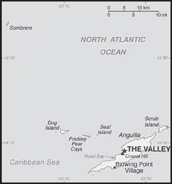
Location: Caribbean, islands between the Caribbean Sea and North Atlantic Ocean, east of Puerto Rico
Geographic coordinates: 18 15 N, 63 10 W
Map references: Central America and the Caribbean
Area: total: 91 sq km
land: 91 sq km
water: 0 sq km
comparison ranking: total 226
Area - comparative: about one-half the size of Washington, DC
Land boundaries: total: 0 km
Coastline: 61 km
Maritime claims: territorial sea: 12 nm
exclusive economic zone: 200 nm
exclusive fishing zone: 200 nm
Climate: tropical; moderated by northeast trade winds
Terrain: flat and low-lying island of coral and limestone
Elevation: highest point: Crocus Hill 73 m
lowest point: Caribbean Sea 0 m
Natural resources: salt, fish, lobster
Land use: agricultural land: 0% (2018 est.)
arable land: 0% (2018 est.)
permanent crops: 0% (2018 est.)
permanent pasture: 0% (2018 est.)
forest: 61.1% (2018 est.)
other: 38.9% (2018 est.)
Irrigated land: 0 sq km (2020)
Population distribution: most of the population is concentrated in The Valley in the center of the island; settlmement is fairly uniform in the southwest, but rather sparce in the northeast
Natural hazards: frequent hurricanes and other tropical storms (July to October)
Geography - note: the most northerly of the Leeward Islands in the Lesser Antilles
PEOPLE AND SOCIETY
Population: 19,079 (2023 est.)
comparison ranking: 219
Nationality: noun: Anguillan(s)
adjective: Anguillan
Ethnic groups: African/Black 85.3%, Hispanic 4.9%, mixed 3.8%, White 3.2%, East Indian/Indian 1%, other 1.6%, unspecified 0.3% (2011 est.)
note: data represent population by ethnic origin
Languages: English (official)
Religions: Protestant 73.2% (includes Anglican 22.7%, Methodist 19.4%, Pentecostal 10.5%, Seventh Day Adventist 8.3%, Baptist 7.1%, Church of God 4.9%, Presbyterian 0.2%, Brethren 0.1%), Roman Catholic 6.8%, Jehovah’s Witness 1.1%, other Christian 10.9%, other 3.2%, unspecified 0.3%, none 4.5% (2011 est.)
Age structure: 0-14 years: 21% (male 2,034/female 1,972)
15-64 years: 67.88% (male 5,896/female 7,055)
65 years and over: 11.12% (2023 est.) (male 1,037/female 1,085)
Dependency ratios: total dependency ratio: 38.6
youth dependency ratio: 24.4
elderly dependency ratio: 14.1
potential support ratio: 7.1 (2021)
Median age: total: 35.7 years (2020)
male: 33.7 years
female: 37.6 years
comparison ranking: total 81
Population growth rate: 1.77% (2023 est.)
comparison ranking: 52
Birth rate: 11.9 births/1,000 population (2023 est.)
comparison ranking: 155
Death rate: 4.72 deaths/1,000 population (2023 est.)
comparison ranking: 202
Net migration rate: 10.48 migrant(s)/1,000 population (2023 est.)
comparison ranking: 9
Population distribution: most of the population is concentrated in The Valley in the center of the island; settlmement is fairly uniform in the southwest, but rather sparce in the northeast
Urbanization: urban population: 100% of total population (2023)
rate of urbanization: 0.47% annual rate of change (2020-25 est.)
Major urban areas - population: 1,000 THE VALLEY (capital) (2018)
Sex ratio: at birth: 1.03 male(s)/female
0-14 years: 1.03 male(s)/female
15-64 years: 0.84 male(s)/female
65 years and over: 0.96 male(s)/female
total population: 0.89 male(s)/female (2023 est.)
Infant mortality rate: total: 3.02 deaths/1,000 live births (2023 est.)
male: 3.94 deaths/1,000 live births
female: 2.08 deaths/1,000 live births
comparison ranking: total 211
Life expectancy at birth: total population: 82.41 years (2023 est.)
male: 79.81 years
female: 85.08 years
comparison ranking: total population 26
Total fertility rate: 1.72 children born/woman (2023 est.)
comparison ranking: 162
Gross reproduction rate: 0.85 (2023 est.)
Drinking water source: improved: total: 97.5% of population
unimproved: total: 2.5% of population (2017 est.)
Sanitation facility access: improved: total: 99.1% of population
unimproved: total: 0.9% of population (2017 est.)
Currently married women (ages 15-49): 46.1% (2023 est.)
Education expenditures: 4% of GDP (2020 est.)
comparison ranking: 119
ENVIRONMENT
Environment - current issues: supplies of potable water sometimes cannot meet increasing demand largely because of poor distribution system
Climate: tropical; moderated by northeast trade winds
Land use: agricultural land: 0% (2018 est.)
forest: 61.1% (2018 est.)
other: 38.9% (2018 est.)
Urbanization: urban population: 100% of total population (2023)
rate of urbanization: 0.47% annual rate of change (2020-25 est.)
GOVERNMENT
Country name: conventional long form: none
conventional short form: Anguilla
etymology: the name Anguilla means “eel” in various Romance languages (Spanish, Italian, Portuguese, French) and likely derives from the island’s lengthy shape
Government type: parliamentary democracy (House of Assembly); self-governing overseas territory of the UK
Dependency status: overseas territory of the UK
Capital: name: The Valley
geographic coordinates: 18 13 N, 63 03 W
time difference: UTC-4 (1 hour ahead of Washington, DC, during Standard Time)
etymology: name derives from the capital’s location between several hills
Administrative divisions: none (overseas territory of the UK)
Independence: none (overseas territory of the UK)
National holiday: Anguilla Day, 30 May (1967)
Constitution: history: several previous; latest 1 April 1982
amendments: amended 1990, 2012, 2017, 2019
Legal system: common law based on the English model
Citizenship: see United Kingdom
Suffrage: 18 years of age; universal
Executive branch: chief of state: King CHARLES III (since 8 September 2022); represented by Governor Julia CROUCH (since 11 September 2023)
head of government: Premier Dr. Ellis WEBSTER (since 30 June 2020); note - starting in 2019, the title of head of government was changed to premier from chief minister of Anguilla
cabinet: Executive Council appointed by the governor from among elected members of the House of Assembly
elections/appointments: the monarchy is hereditary; governor appointed by the monarch; following legislative elections, the leader of the majority party or majority coalition usually appointed premier by the governor
Legislative branch: description: unicameral House of Assembly (11 seats; 7 members directly elected in single-seat constituencies by simple majority vote, 2 appointed by the governor, and 2 ex officio members - the attorney general and deputy governor; members serve five-year terms)
elections: last held on 29 June 2020 (next to be held in 2025)
election results: percent of vote by party - NA; seats by party - APM 7, AUF 4; composition - men 8, women 3, percent of women 27.3%
Judicial branch: highest court(s): the Eastern Caribbean Supreme Court (ECSC) is the superior court of the Organization of Eastern Caribbean States; the ECSC - headquartered on St. Lucia - consists of the Court of Appeal - headed by the chief justice and 4 judges - and the High Court with 18 judges; the Court of Appeal is itinerant, travelling to member states on a schedule to hear appeals from the High Court and subordinate courts; High Court judges reside in the member states, though none on Anguilla
judge selection and term of office: Eastern Caribbean Supreme Court chief justice appointed by Her Majesty, Queen ELIZABETH II; other justices and judges appointed by the Judicial and Legal Services Commission; Court of Appeal justices appointed for life with mandatory retirement at age 65; High Court judges appointed for life with mandatory retirement at age 62
subordinate courts: Magistrate’s Court; Juvenile Court
Political parties and leaders: Anguilla Progressive Movement or APM [Dr. Ellis WEBSTER]; (formerly Anguilla United Movement or AUM)
Anguilla United Front or AUF [Cora RICHARDSON-HODGE]
International organization participation: Caricom (associate), CDB, Interpol (subbureau), OECS, UNESCO (associate), UPU
Diplomatic representation in the US: none (overseas territory of the UK)
Diplomatic representation from the US: embassy: none (overseas territory of the UK); alternate contact is the US Embassy in Barbados [1] (246) 227-4000
Flag description: blue, with the flag of the UK in the upper hoist-side quadrant and the Anguillan coat of arms centered in the outer half of the flag; the coat of arms depicts three orange dolphins in an interlocking circular design on a white background with a turquoise-blue field below; the white in the background represents peace; the blue base symbolizes the surrounding sea, as well as faith, youth, and hope; the three dolphins stand for endurance, unity, and strength
National symbol(s): dolphin
National anthem: name: “God Bless Anguilla”
lyrics/music: Alex RICHARDSON
note: local anthem adopted 1981; as an overseas territory of the United Kingdom, “God Save the King” is official (see United Kingdom)
ECONOMY
Economic overview: small, tourism-dependent, territorial-island economy; very high public debt; COVID-19 crippled economic activity; partial recovery underway via tourism, benefitting from its high amount of timeshare residences; considering reopening oil refinery
Real GDP (purchasing power parity): $175.4 million (2009 est.)
$191.7 million (2008 est.)
$108.9 million (2004 est.)
comparison ranking: 222
Real GDP growth rate: -8.5% (2009 est.)
comparison ranking: 218
Real GDP per capita: $12,200 (2008 est.)
comparison ranking: 129
GDP (official exchange rate): $175.4 million (2009 est.)
Inflation rate (consumer prices): 1.3% (2017 est.)
-0.6% (2016 est.)
comparison ranking: 187
GDP - composition, by sector of origin: agriculture: 3% (2017 est.)
industry: 10.5% (2017 est.)
services: 86.4% (2017 est.)
comparison rankings: services 15; industry 203; agriculture 152
GDP - composition, by end use: household consumption: 74.1% (2017 est.)
government consumption: 18.3% (2017 est.)
investment in fixed capital: 26.8% (2017 est.)
investment in inventories: 0% (2017 est.)
exports of goods and services: 48.2% (2017 est.)
imports of goods and services: -67.4% (2017 est.)
Agricultural products: small quantities of tobacco, vegetables; cattle raising
Industries: tourism, boat building, offshore financial services
Industrial production growth rate: 4% (2017 est.)
comparison ranking: 104
Labor force: 6,049 (2001)
comparison ranking: 219
Labor force - by occupation: agriculture: 74.1%
industry: 3%
services: 18%
agriculture/fishing/forestry/mining: 4% (2000 est.)
manufacturing: 3% (2000 est.)
construction: 18% (2000 est.)
transportation and utilities: 10% (2000 est.)
commerce: 36% (2000 est.)
Unemployment rate: 8% (2002)
comparison ranking: 96
Population below poverty line: 23% (2002 est.)
Budget: revenues: $81.92 million (2017 est.)
expenditures: $80.32 million (2017 est.)
Budget surplus (+) or deficit (-): 0.9% (of GDP) (2017 est.)
comparison ranking: 34
Public debt: 20.1% of GDP (2015 est.)
20.8% of GDP (2014 est.)
comparison ranking: 190
Taxes and other revenues: 46.7% (of GDP) (2017 est.)
comparison ranking: 7
Fiscal year: 1 April - 31 March
Current account balance: -$23.2 million (2017 est.)
-$25.3 million (2016 est.)
comparison ranking: 85
Exports: $7.9 million (2017 est.)
$3.9 million (2016 est.)
note: Data are in current year dollars and do not include illicit exports or re-exports.
comparison ranking: 220
Exports - commodities: packaged medicines, vaccines and cultures, used clothing, orthopedic appliances, blank audio media (2021)
Imports: $186.2 million (2017 est.)
$170.1 million (2016 est.)
comparison ranking: 213
Imports - commodities: fuels, foodstuffs, manufactures, chemicals, trucks, textiles
Reserves of foreign exchange and gold: $76.38 million (31 December 2017 est.)
$48.14 million (31 December 2015 est.)
comparison ranking: 189
Debt - external: $41.04 million (31 December 2013)
$8.8 million (1998)
comparison ranking: 195
Exchange rates: East Caribbean dollars (XCD) per US dollar -
Exchange rates: 2.7 (2017 est.)
2.7 (2016 est.)
2.7 (2015 est.)
2.7 (2014 est.)
2.7 (2013 est.)
ENERGY
Electricity access: electrification - total population: 100% (2020)
COMMUNICATIONS
Telephones - fixed lines: total subscriptions: 6,000 (2021 est.)
subscriptions per 100 inhabitants: 38 (2021 est.)
comparison ranking: total subscriptions 201
Telephones - mobile cellular: total subscriptions: 26,000 (2021 est.)
subscriptions per 100 inhabitants: 170 (2021 est.)
comparison ranking: total subscriptions 212
Telecommunication systems: general assessment: in the telecom sector, with declines seen in subscriber numbers (particularly for prepaid mobile services — the mainstay of short-term visitors) and revenue; fixed and mobile broadband services are two areas that have benefited from the crisis to a small extent as employees and students have resorted to working from home, but their contribution to the sector has been insufficient to offset steep falls in other areas of the market; one area of the telecom market that does not yet appear poised for growth is 5G mobile; governments, regulators, and even the mobile network operators have shown that they have little appetite for investing in 5G opportunities at the present time; network expansion and enhancements remain concentrated around improving LTE coverage; until the economies and markets stabilize, and overseas visitors return there is unlikely to be much momentum towards implementing 5G capabilities anywhere in the region (2021)
domestic: fixed-line teledensity is about 38 per 100 persons; mobile-cellular teledensity is roughly 170 per 100 persons (2021)
international: country code - 1-264; landing points for the SSCS, ECFS, GCN and Southern Caribbean Fiber with submarine cable links to Caribbean islands and to the US; microwave radio relay to island of Saint Martin/Sint Maarten (2019)
Broadcast media: 1 private TV station; multi-channel cable TV subscription services are available; about 10 radio stations, one of which is government-owned
Internet country code: .ai
Internet users: total: 13,056 (2021 est.)
percent of population: 81.6% (2021 est.)
comparison ranking: total 215
Broadband - fixed subscriptions: total: 5,000 (2018 est.)
subscriptions per 100 inhabitants: 35 (2018 est.)
comparison ranking: total 186
TRANSPORTATION
National air transport system: number of registered air carriers: 2 (2020)
inventory of registered aircraft operated by air carriers: 4
Civil aircraft registration country code prefix: VP-A
Airports: 1 (2021)
comparison ranking: total 227
Airports - with paved runways: 1
note: paved runways have a concrete or asphalt surface but not all have facilities for refueling, maintenance, or air traffic control; the length of a runway required for aircraft to safely operate depends on a number of factors including the type of aircraft, the takeoff weight (including passengers, cargo, and fuel), engine types, flap settings, landing speed, elevation of the airport, and average maximum daily air temperature; paved runways can reach a length of 5,000 m (16,000 ft.), but the “typical” length of a commercial airline runway is between 2,500-4,000 m (8,000-13,000 ft.)
Roadways: total: 175 km (2004)
paved: 82 km (2004)
unpaved: 93 km (2004)
comparison ranking: total 209
Merchant marine: total: 2 (2022)
by type: other 2
comparison ranking: total 176
Ports and terminals: major seaport(s): Blowing Point, Road Bay
MILITARY AND SECURITY
Military - note: defense is the responsibility of the UK
TRANSNATIONAL ISSUES
Disputes - international: none identified
Illicit drugs: transshipment point for South American narcotics destined for the US and Europe
INTRODUCTION
Background: Speculation over the existence of a “southern land” was not confirmed until the early 1820s when British and American commercial operators and British and Russian national expeditions began exploring the Antarctic Peninsula region and other areas south of the Antarctic Circle. Not until 1840 was it established that Antarctica was indeed a continent and not merely a group of islands or an area of ocean. Several exploration “firsts” were achieved in the early 20th century, but generally the area saw little human activity. Following World War II, however, the continent experienced an upsurge in scientific research. A number of countries have set up a range of year-round and seasonal stations, camps, and refuges to support scientific research in Antarctica. Seven have made territorial claims and two maintain the basis for a claim, but most countries do not recognize these claims. In order to form a legal framework for the activities of nations on the continent, an Antarctic Treaty was negotiated that neither denies nor gives recognition to existing territorial claims; signed in 1959, it entered into force in 1961. Also relevant to Antarctic governance are the Environmental Protocol to the Antarctic Treaty and the Convention for the Conservation of Antarctic Marine Living Resources.
GEOGRAPHY
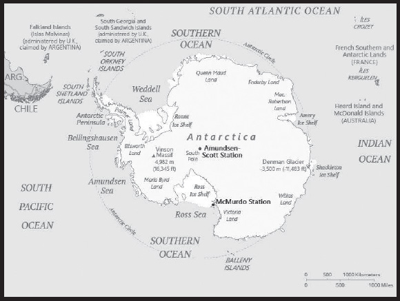
Location: continent mostly south of the Antarctic Circle
Geographic coordinates: 90 00 S, 0 00 E
Map references: Antarctic Region
Area: total: 14.2 million sq km
land: 14.2 million sq km (285,000 sq km ice-free, 13.915 million sq km ice-covered) (est.)
note: fifth-largest continent, following Asia, Africa, North America, and South America, but larger than Australia and the subcontinent of Europe
comparison ranking: total 2
Area - comparative: slightly less than 1.5 times the size of the US
Land boundaries: 0 note: see entry on Disputes - international
Coastline: 17,968 km
Maritime claims: Australia, Chile, and Argentina claim Exclusive Economic Zone (EEZ) rights or similar over 200 nm extensions seaward from their continental claims, but like the claims themselves, these zones are not accepted by other countries; 22 of 29 Antarctic Treaty consultative parties have made no claims to Antarctic territory, although Russia and the United States have reserved the right to do so, and no country can make a new claim; also see the Disputes - international entry
Climate: the coldest, windiest, and driest continent on Earth; severe low temperatures vary with latitude, elevation, and distance from the ocean; East Antarctica is colder than West Antarctica because of its higher elevation; Antarctic Peninsula has the most moderate climate; higher temperatures occur in January along the coast and average slightly below freezing; summers characterized by continuous daylight, while winters bring continuous darkness; persistent high pressure over the interior brings dry, subsiding air that results in very little cloud cover
Terrain: about 99% thick continental ice sheet and 1% barren rock, with average elevations between 2,000 and 4,000 m; mountain ranges up to nearly 5,000 m; ice-free coastal areas include parts of southern Victoria Land, Wilkes Land, the Antarctic Peninsula area, and parts of Ross Island on McMurdo Sound; glaciers form ice shelves along about half of the coastline, and floating ice shelves constitute 11% of the area of the continent
Elevation: highest point: Vinson Massif 4,892 m
lowest point: Denman Glacier more than -3,500 m (-11,500 ft) below sea level
mean elevation: 2,300 m
note: the lowest known land point in Antarctica is hidden in the Denman Glacier; at its surface is the deepest ice yet discovered and the world’s lowest elevation not under seawater
Natural resources: iron ore, chromium, copper, gold, nickel, platinum and other minerals, and coal and hydrocarbons have been found in small noncommercial quantities; mineral exploitation except for scientific research is banned by the Environmental Protocol to the Antarctic Treaty; krill, icefish, toothfish, and crab have been taken by commercial fisheries, which are managed through the Commission for the Conservation of Antarctic Living Marine Resources (CCAMLR)
Land use: agricultural land: 0% (2018 est.)
Natural hazards: katabatic (gravity-driven) winds blow coastward from the high interior; frequent blizzards form near the foot of the plateau; cyclonic storms form over the ocean and move clockwise along the coast; large icebergs may calve from ice shelf
volcanism: volcanic activity on Deception Island and isolated areas of West Antarctica; other seismic activity rare and weak
Geography - note: the coldest, windiest, highest (on average), and driest continent; during summer, more solar radiation reaches the surface at the South Pole than is received at the Equator in an equivalent period
mostly uninhabitable, 99% of the land area is covered by the Antarctic ice sheet, the largest single mass of ice on earth covering an area of 14 million sq km (5.4 million sq mi) and containing 26.5 million cu km (6.4 million cu mi) of ice (this is almost 62% of all of the world’s fresh water); if all this ice were converted to liquid water, one estimate is that it would be sufficient to raise the height of the world’s oceans by 58 m (190 ft)
PEOPLE AND SOCIETY
Population: no indigenous inhabitants, but there are both year-round and summer-only staffed research stations
note: 54 countries have signed the 1959 Antarctic Treaty; 30 of those operate through their National Antarctic Program a number of seasonal-only (summer) and year-round research stations on the continent and its nearby islands south of 60 degrees south latitude (the region covered by the Antarctic Treaty); the population engaging in and supporting science or managing and protecting the Antarctic region varies from approximately 5,000 in summer to 1,100 in winter; in addition, approximately 1,000 personnel, including ship’s crew and scientists doing onboard research, are present in the waters of the treaty region
as of 2017, peak summer (December-February) maximum capacity in scientific stations - 4,877 total; Argentina 601, Australia 243, Belarus 12, Belgium 40, Brazil 66, Bulgaria 22, Chile 433, China 166, Czechia 20, Ecuador 34, Finland 17, France 90, France and Italy jointly 80, Germany 104, India 113, Italy 120, Japan 130, South Korea 130, Netherlands 10, NZ 86, Norway 70, Peru 30, Poland 40, Russia 335, South Africa 80, Spain 98, Sweden 20, Ukraine 24, UK 196, US 1,399, Uruguay 68 (2017)
winter (June-August) maximum capacity in scientific station - 1,036 total; Argentina 221, Australia 52, Brazil 15, Chile 114, China 32, France 24, France and Italy jointly 13, Germany 9, India 48, Japan 40, Netherlands 10, South Korea 25, NZ 11, Norway 7, Poland 16, Russia 125, South Africa 15, Ukraine 12, UK 44, US 215, Uruguay 8 (2017)
research stations operated within the Antarctic Treaty area (south of 60 degrees south latitude) by National Antarctic Programs year-round stations - approximately 40 total; Argentina 6, Australia 3, Brazil 1, Chile 6, China 2, France 1, France and Italy jointly 1, Germany 1, India 2, Japan 1, Netherlands 1, South Korea 2, NZ 1, Norway 1, Poland 1, Russia 5, South Africa 1, Ukraine 1, UK 2, US 3, Uruguay 2 (2017)
a range of seasonal-only (summer) stations, camps, and refuges - Argentina, Australia, Belarus, Belgium, Bulgaria, Brazil, Chile, China, Czechia, Ecuador, Finland, France, Germany, India, Italy, Japan, Netherlands, South Korea, New Zealand, Norway, Peru, Poland, Russia, South Africa, Spain, Sweden, Ukraine, UK, US, and Uruguay (2017)
in addition, during the austral summer some nations have numerous occupied locations such as tent camps, summer- long temporary facilities, and mobile traverses in support of research
ENVIRONMENT
Environment - current issues: the discovery of a large Antarctic ozone hole in the earth’s stratosphere (the ozone layer) - first announced in 1985 - spurred the signing of the Montreal Protocol in 1987, an international agreement phasing out the use of ozone-depleting chemicals; the ozone layer prevents most harmful wavelengths of ultra-violet (UV) light from passing through the earth’s atmosphere; ozone depletion has been shown to harm a variety of Antarctic marine plants and animals (plankton); in 2016, a gradual trend toward “healing” of the ozone hole was reported; since the 1990s, satellites have shown accelerating ice loss driven by ocean change; although considerable uncertainty remains, scientists are increasing our understanding and ability to model potential impacts of ice loss
Climate: the coldest, windiest, and driest continent on Earth; severe low temperatures vary with latitude, elevation, and distance from the ocean; East Antarctica is colder than West Antarctica because of its higher elevation; Antarctic Peninsula has the most moderate climate; higher temperatures occur in January along the coast and average slightly below freezing; summers characterized by continuous daylight, while winters bring continuous darkness; persistent high pressure over the interior brings dry, subsiding air that results in very little cloud cover
Land use: agricultural land: 0% (2018 est.)
GOVERNMENT
Country name: conventional long form: none
conventional short form: Antarctica
etymology: name derived from two Greek words meaning “opposite to the Arctic” or “opposite to the north”
Government type: Antarctic Treaty Summary - the Antarctic region is governed by a system known as the Antarctic Treaty system; the system includes: 1. the Antarctic Treaty, signed on 1 December 1959 and entered into force on 23 June 1961, which establishes the legal framework for the management of Antarctica, 2. Measures, Decisions, and Resolutions adopted at Antarctic Treaty Consultative Meetings, 3. The Convention for the Conservation of Antarctic Seals (1972), 4. The Convention for the Conservation of Antarctic Marine Living Resources (1980), and 5. The Protocol on Environmental Protection to the Antarctic Treaty (1991); the Antarctic Treaty Consultative Meetings operate by consensus (not by vote) of all consultative parties at annual Treaty meetings; by January 2022, there were 54 treaty member nations: 29 consultative and 25 non-consultative; consultative (decision-making) members include the seven nations that claim portions of Antarctica as national territory (some claims overlap) and 22 non-claimant nations; the US and Russia have reserved the right to make claims; the US does not recognize the claims of others; Antarctica is administered through meetings of the consultative member nations; measures adopted at these meetings are carried out by these member nations (with respect to their own nationals and operations) in accordance with their own national laws; the years in parentheses indicate when a consultative member-nation acceded to the Treaty and when it was accepted as a consultative member, while no date indicates the country was an original 1959 treaty signatory; claimant nations are - Argentina, Australia, Chile, France, NZ, Norway, and the UK; nonclaimant consultative nations are - Belgium, Brazil (1975/1983), Bulgaria (1978/1998), China (1983/1985), Czechia (1962/2014), Ecuador (1987/1990), Finland (1984/1989), Germany (1979/1981), India (1983/1983), Italy (1981/1987), Japan, South Korea (1986/1989), Netherlands (1967/1990), Peru (1981/1989), Poland (1961/1977), Russia, South Africa, Spain (1982/1988), Sweden (1984/1988), Ukraine (1992/2004), Uruguay (1980/1985), and the US; non-consultative members, with year of accession in parentheses, are - Austria (1987), Belarus (2006), Canada (1988), Colombia (1989), Cuba (1984), Denmark (1965), Estonia (2001), Greece (1987), Guatemala (1991), Hungary (1984), Iceland (2015), Kazakhstan (2015), North Korea (1987), Malaysia (2011), Monaco (2008), Mongolia (2015), Pakistan (2012), Papua New Guinea (1981), Portugal (2010), Romania (1971), Slovakia (1962/1993), Slovenia (2019), Switzerland (1990), Turkey (1996), and Venezuela (1999); note - Czechoslovakia acceded to the Treaty in 1962 and separated into the Czech Republic and Slovakia in 1993; Article 1 - area to be used for peaceful purposes only; military activity, such as weapons testing, is prohibited, but military personnel and equipment may be used for scientific research or any other peaceful purpose; Article 2 - freedom of scientific investigation and cooperation shall continue; Article 3 - free exchange of information and personnel, cooperation with the UN and other international agencies; Article 4 - does not recognize, dispute, or establish territorial claims and no new claims shall be asserted while the treaty is in force; Article 5 - prohibits nuclear explosions or disposal of radioactive wastes; Article 6 - includes under the treaty all land and ice shelves south of 60 degrees 00 minutes south and reserves high seas rights; Article 7 - treaty-state observers have free access, including aerial observation, to any area and may inspect all stations, installations, and equipment; advance notice of all expeditions and of the introduction of military personnel must be given; Article 8 - allows for jurisdiction over observers and scientists by their own states; Article 9 - frequent consultative meetings take place among member nations; Article 10 - treaty states will discourage activities by any country in Antarctica that are contrary to the treaty; Article 11 - disputes to be settled peacefully by the parties concerned or, ultimately, by the International Court of Justice; Articles 12, 13, 14 - deal with upholding, interpreting, and amending the treaty among involved nations; other agreements - some 200 measures adopted at treaty consultative meetings and approved by governments; the Protocol on Environmental Protection to the Antarctic Treaty was signed 4 October 1991 and entered into force 14 January 1998; this agreement provides for the protection of the Antarctic environment and includes five annexes that have entered into force: 1) environmental impact assessment, 2) conservation of Antarctic fauna and flora, 3) waste disposal and waste management, 4) prevention of marine pollution, 5) area protection and management; a sixth annex addressing liability arising from environmental emergencies has yet to enter into force; the Protocol prohibits all activities relating to mineral resources except scientific research; a permanent Antarctic Treaty Secretariat was established in 2004 in Buenos Aires, Argentina
Legal system: Antarctica is administered through annual meetings - known as Antarctic Treaty Consultative Meetings - which include consultative member nations, non-consultative member nations, observer organizations, and expert organizations; decisions from these meetings are carried out by these member nations (with respect to their own nationals and operations) in accordance with their own national laws; more generally, the Antarctic Treaty area, that is to all areas between 60 and 90 degrees south latitude, is subject to a number of relevant legal instruments and procedures adopted by the states party to the Antarctic Treaty; note - US law, including certain criminal offenses by or against US nationals, such as murder, may apply extraterritoriality; some US laws directly apply to Antarctica; for example, the Antarctic Conservation Act, 16 U.S.C. section 2401 et seq., provides civil and criminal penalties for the following activities unless authorized by regulation or statute: the taking of native mammals or birds; the introduction of nonindigenous plants and animals; entry into specially protected areas; the discharge or disposal of pollutants; and the importation into the US of certain items from Antarctica; violation of the Antarctic Conservation Act carries penalties of up to $10,000 in fines and one year in prison; the National Science Foundation and Department of Justice share enforcement responsibilities; Public Law 95-541, the US Antarctic Conservation Act of 1978, as amended in 1996, requires expeditions from the US to Antarctica to notify, in advance, the Office of Oceans and Polar Affairs, Room 2665, Department of State, Washington, DC 20520, which reports such plans to other nations as required by the Antarctic Treaty; for more information, contact antarctica@state.gov
Flag description: unofficial; a True South flag, created in 2018, has quickly become popular for its simple yet elegant design and has been used by various National Antarctic Programs, Antarctic nonprofits, and expedition teams; the flag’s meaning is described as: horizontal stripes of navy and white represent the long days and nights at Antarctica’s extreme latitude; in the center, a lone white peak erupts from a field of snow and ice, echoing those of the bergs, mountains, and pressure ridges that define the Antarctic horizon; the long shadow it casts forms the unmistakable shape of a compass arrow pointed south, an homage to the continent’s legacy of exploration; together, the two center shapes create a diamond, symbolizing the hope that Antarctica will continue to be a center of peace, discovery, and cooperation for generations to come
ENERGY
Electricity: installed generating capacity: 0 kW (2020 est.)
transmission/distribution losses: 0 kWh (2019 est.)
comparison rankings: imports 133; exports 116; installed generating capacity 212; transmission/distribution losses 211; consumption 210
Petroleum: total petroleum production: 0 bbl/day (2021 est.)
refined petroleum consumption: 100 bbl/day (2019 est.)
Carbon dioxide emissions: 28,000 metric tonnes of CO2 (2019 est.)
from petroleum and other liquids: 28,000 metric tonnes of CO2 (2019 est.)
comparison ranking: total emissions 214
Energy consumption per capita: 0 Btu/person (2019 est.)
comparison ranking: 206
COMMUNICATIONS
Telecommunication systems: general assessment: scientists with the United States Antarctic Program at McMurdo Station have now got their hands on a Starlink terminal of their own, where it is said to be improving connectivity as they carry out their research; this was made possible through laser links between the SpaceX satellites in orbit that eliminate the need for ground stations at the poles, and makes Antarctica the seventh and final continent to receive Starlink internet coverage (2022)
domestic: commercial cellular networks operating in a small number of locations (2019)
international: country code - none allocated; via satellite (including mobile Inmarsat and Iridium systems) to and from all research stations, ships, aircraft, and most field parties
Internet country code: .aq
Internet users: total: 4,400 (2021 est.)
percent of population: 100% (2021 est.)
comparison ranking: total 224
TRANSPORTATION
Airports: 17 (2021)
comparison ranking: total 141
Airports - with unpaved runways: 17
note: unpaved runways have a surface composition such as snow, grass, and packed earth and are most suited to the operation of light aircraft; unpaved runways are usually short, often less than 1,000 m (3,280 ft.) in length; airports with unpaved runways often lack facilities for refueling, maintenance, or air traffic control
Heliports: 53 (2021)
note: all year-round and seasonal stations operated by National Antarctic Programs stations have some kind of helicopter landing facilities, prepared (helipads) or unprepared
Ports and terminals: most coastal stations have sparse and intermittent offshore anchorages; a few stations have basic wharf facilities
Transportation - note: US coastal stations include McMurdo (77 51 S, 166 40 E) and Palmer (64 43 S, 64 03 W); government use only; all ships are subject to inspection in accordance with Article 7, Antarctic Treaty; relevant legal instruments and authorization procedures adopted by the states parties to the Antarctic Treaty regulating the Antarctic Treaty area have to be complied with (see “Legal System”); The Hydrographic Commission on Antarctica (HCA), a commission of the International Hydrographic Organization (IHO), is responsible for hydrographic surveying and nautical charting matters in Antarctic Treaty area; it coordinates and facilitates provision of accurate and appropriate charts and other aids to navigation in support of safety of navigation in region; membership of HCA is open to any IHO Member State whose government has acceded to the Antarctic Treaty and which contributes resources or data to IHO Chart coverage of the area
MILITARY AND SECURITY
Military - note: the Antarctic Treaty of 1961 prohibits any measures of a military nature, such as the establishment of military bases and fortifications, the carrying out of military maneuvers, or the testing of any type of weapon; it permits the use of military personnel or equipment for scientific research or for any other peaceful purposes
TRANSNATIONAL ISSUES
Disputes - international: the Antarctic Treaty freezes, and most states do not recognize, the land and maritime territorial claims made by Argentina, Australia, Chile, France, New Zealand, Norway, and the UK (some overlapping) for three-fourths of the continent; the US and Russia reserve the right to make claims
INTRODUCTION
Background: The Siboney were the first people to inhabit the islands of Antigua and Barbuda in 2400 B.C., but Arawak Indians populated the islands when Christopher COLUMBUS landed on his second voyage in 1493. Early Spanish and French settlements were succeeded by an English colony in 1667. Slavery, to provide labor on the sugar plantations on Antigua, was abolished in 1834. The islands became an independent state within the British Commonwealth of Nations in 1981. On 6 September 2017, Hurricane Irma passed over the island of Barbuda devastating the island and forcing the evacuation of the population to Antigua. Almost all of the structures on Barbuda were destroyed and the vegetation stripped, but Antigua was spared the worst.
GEOGRAPHY
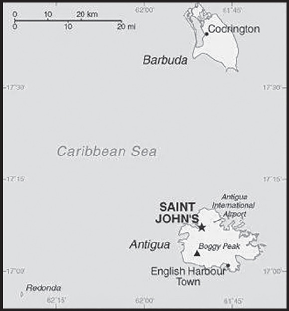
Location: Caribbean, islands between the Caribbean Sea and the North Atlantic Ocean, east-southeast of Puerto Rico
Geographic coordinates: 17 03 N, 61 48 W
Map references: Central America and the Caribbean
Area: total: 443 sq km (Antigua 280 sq km; Barbuda 161 sq km)
land: 443 sq km
water: 0 sq km
note: includes Redonda, 1.6 sq km
comparison ranking: total 200
Area - comparative: 2.5 times the size of Washington, DC
Land boundaries: total: 0 km
Coastline: 153 km
Maritime claims: territorial sea: 12 nm
contiguous zone: 24 nm
exclusive economic zone: 200 nm
continental shelf: 200 nm or to the edge of the continental margin
Climate: tropical maritime; little seasonal temperature variation
Terrain: mostly low-lying limestone and coral islands, with some higher volcanic areas
Elevation: highest point: Mount Obama 402 m
lowest point: Caribbean Sea 0 m
Natural resources: NEGL; pleasant climate fosters tourism
Land use: agricultural land: 20.5% (2018 est.)
arable land: 9% (2018 est.)
permanent crops: 2.3% (2018 est.)
permanent pasture: 9% (2018 est.)
forest: 18.8% (2018 est.)
other: 60.8% (2018 est.)
Irrigated land: 1.3 sq km (2012)
Population distribution: the island of Antigua is home to approximately 97% of the population; nearly the entire population of Barbuda lives in Codrington
Natural hazards: hurricanes and tropical storms (July to October); periodic droughts
Geography - note: Antigua has a deeply indented shoreline with many natural harbors and beaches; Barbuda has a large western harbor
PEOPLE AND SOCIETY
Population: 101,489 (2023 est.)
comparison ranking: 194
Nationality: noun: Antiguan(s), Barbudan(s)
adjective: Antiguan, Barbudan
Ethnic groups: African descent 87.3%, mixed 4.7%, Hispanic 2.7%, White 1.6%, other 2.7%, unspecified 0.9% (2011 est.)
note: data represent population by ethnic group
Languages: English (official), Antiguan Creole (an English-based creole)
Religions: Protestant 68.3% (Anglican 17.6%, Seventh Day Adventist 12.4%, Pentecostal 12.2%, Moravian 8.3%, Methodist 5.6%, Wesleyan Holiness 4.5%, Church of God 4.1%, Baptist 3.6%), Roman Catholic 8.2%, other 12.2%, unspecified 5.5%, none 5.9% (2011 est.)
Age structure: 0-14 years: 21.97% (male 11,321/female 10,980)
15-64 years: 67.94% (male 32,103/female 36,847)
65 years and over: 10.09% (2023 est.) (male 4,378/female 5,860)
Dependency ratios: total dependency ratio: 40.9
youth dependency ratio: 26.5
elderly dependency ratio: 14.4
potential support ratio: 7 (2020 est.)
Median age: total: 32.7 years (2020)
male: 30.7 years
female: 34.4 years
comparison ranking: total 107
Population growth rate: 1.13% (2023 est.)
comparison ranking: 81
Birth rate: 15.01 births/1,000 population (2023 est.)
comparison ranking: 113
Death rate: 5.69 deaths/1,000 population (2023 est.)
comparison ranking: 172
Net migration rate: 2.01 migrant(s)/1,000 population (2023 est.)
comparison ranking: 48
Population distribution: the island of Antigua is home to approximately 97% of the population; nearly the entire population of Barbuda lives in Codrington
Urbanization: urban population: 24.3% of total population (2023)
rate of urbanization: 0.87% annual rate of change (2020-25 est.)
Major urban areas - population: 21,000 SAINT JOHN’S (capital) (2018)
Sex ratio: at birth: 1.05 male(s)/female
0-14 years: 1.03 male(s)/female
15-64 years: 0.87 male(s)/female
65 years and over: 0.75 male(s)/female
total population: 0.89 male(s)/female (2023 est.)
Maternal mortality ratio: 21 deaths/100,000 live births (2020)
comparison ranking: 120
Infant mortality rate: total: 13.95 deaths/1,000 live births (2023 est.)
male: 16.84 deaths/1,000 live births
female: 10.91 deaths/1,000 live births
comparison ranking: total 106
Life expectancy at birth: total population: 78.04 years (2023 est.)
male: 75.88 years
female: 80.31 years
comparison ranking: total population 85
Total fertility rate: 1.94 children born/woman (2023 est.)
comparison ranking: 115
Gross reproduction rate: 0.95 (2023 est.)
Drinking water source: improved: total: 96.7% of population
unimproved: total: 3.2% of population (2017 est.)
Current health expenditure: 5.6% of GDP (2020)
Physicians density: 2.76 physicians/1,000 population (2017)
Hospital bed density: 2.9 beds/1,000 population (2017)
Sanitation facility access: improved: total: 91.7% of population
unimproved: total: 8.1% of population (2017 est.)
Obesity - adult prevalence rate: 18.9% (2016)
comparison ranking: 115
Alcohol consumption per capita: total: 11.88 liters of pure alcohol (2019 est.)
beer: 2.97 liters of pure alcohol (2019 est.)
wine: 3.95 liters of pure alcohol (2019 est.)
spirits: 4.55 liters of pure alcohol (2019 est.)
other alcohols: 0.41 liters of pure alcohol (2019 est.)
comparison ranking: total 6
Currently married women (ages 15-49): 31.5% (2023 est.)
Education expenditures: 3.8% of GDP (2021 est.)
comparison ranking: 126
Literacy: definition: age 15 and over has completed five or more years of schooling
total population: 99%
male: 98.4%
female: 99.4% (2015)
School life expectancy (primary to tertiary education): total: 15 years
male: 14 years
female: 16 years (2012)
ENVIRONMENT
Environment - current issues: water management - a major concern because of limited natural freshwater resources - is further hampered by the clearing of trees to increase crop production, causing rainfall to run off quickly
Environment - international agreements: party to: Biodiversity, Climate Change, Climate Change-Kyoto Protocol, Climate Change-Paris Agreement, Comprehensive Nuclear Test Ban, Desertification, Endangered Species, Environmental Modification, Hazardous Wastes, Law of the Sea, Marine Dumping-London Convention, Marine Dumping-London Protocol, Nuclear Test Ban, Ozone Layer Protection, Ship Pollution, Wetlands, Whaling
signed, but not ratified: none of the selected agreements
Climate: tropical maritime; little seasonal temperature variation
Land use: agricultural land: 20.5% (2018 est.)
arable land: 9% (2018 est.)
permanent crops: 2.3% (2018 est.)
permanent pasture: 9% (2018 est.)
forest: 18.8% (2018 est.)
other: 60.8% (2018 est.)
Urbanization: urban population: 24.3% of total population (2023)
rate of urbanization: 0.87% annual rate of change (2020-25 est.)
Revenue from forest resources: 0% of GDP (2018 est.)
comparison ranking: 163
Revenue from coal: 0% of GDP (2018 est.)
comparison ranking: 117
Air pollutants: particulate matter emissions: 8.3 micrograms per cubic meter (2019 est.)
carbon dioxide emissions: 0.56 megatons (2016 est.)
methane emissions: 0.22 megatons (2020 est.)
Waste and recycling: municipal solid waste generated annually: 30,585 tons (2012 est.)
Total water withdrawal: municipal: 10 million cubic meters (2020 est.)
industrial: 2.5 million cubic meters (2017 est.)
agricultural: 1.8 million cubic meters (2017 est.)
Total renewable water resources: 50 million cubic meters (2020 est.)
GOVERNMENT
Country name: conventional long form: none
conventional short form: Antigua and Barbuda
etymology: “antiguo” is Spanish for “ancient” or “old”; the island was discovered by Christopher COLUMBUS in 1493 and, according to tradition, named by him after the church of Santa Maria la Antigua (Old Saint Mary’s) in Seville; “barbuda” is Spanish for “bearded” and the adjective may refer to the alleged beards of the indigenous people or to the island’s bearded fig trees
Government type: parliamentary democracy under a constitutional monarchy; a Commonwealth realm
Capital: name: Saint John’s
geographic coordinates: 17 07 N, 61 51 W
time difference: UTC-4 (1 hour ahead of Washington, DC, during Standard Time)
etymology: named after Saint John the Apostle
Administrative divisions: 6 parishes and 2 dependencies*; Barbuda*, Redonda*, Saint George, Saint John, Saint Mary, Saint Paul, Saint Peter, Saint Philip
Independence: 1 November 1981 (from the UK)
National holiday: Independence Day, 1 November (1981)
Constitution: history: several previous; latest presented 31 July 1981, effective 31 October 1981 (The Antigua and Barbuda Constitution Order 1981)
amendments: proposed by either house of Parliament; passage of amendments to constitutional sections such as citizenship, fundamental rights and freedoms, the establishment, power, and authority of the executive and legislative branches, the Supreme Court Order, and the procedure for amending the constitution requires approval by at least two- thirds majority vote of the membership of both houses, approval by at least two-thirds majority in a referendum, and assent to by the governor general; passage of other amendments requires only two-thirds majority vote by both houses; amended 2009, 2011, 2018
Legal system: common law based on the English model
International law organization participation: has not submitted an ICJ jurisdiction declaration; accepts ICCt jurisdiction
Citizenship: citizenship by birth: yes
citizenship by descent only: yes
dual citizenship recognized: yes
residency requirement for naturalization: 7 years
Suffrage: 18 years of age; universal
Executive branch: chief of state: King CHARLES III (since 8 September 2022); represented by Governor General Rodney WILLIAMS (since 14 August 2014)
head of government: Prime Minister Gaston BROWNE (since 13 June 2014)
cabinet: Council of Ministers appointed by the governor general on the advice of the prime minister
elections/appointments: the monarchy is hereditary; governor general appointed by the monarch on the advice of the prime minister; following legislative elections, the leader of the majority party or majority coalition usually appointed prime minister by the governor general
Legislative branch: description: bicameral Parliament consists of:
Senate (17 seats; members appointed by the governor general on the advice of the prime minister and leader of the opposition; members served 5-year terms)
House of Representatives (19 seats; members directly elected in single-seat constituencies by simple majority vote to serve 5-year terms; in addition, 1 ex-officio seat is allocated for the attorney general and 1 seat for the speaker of the House - elected by the House membership following its first post-election session)
elections: Senate - last appointed on 17 February 2023 (next appointments in 2028)
House of Representatives - last held on 18 January 2023 (next to be held in March 2028)
election results: Senate - composition - men 10, women 7, percent of women 41.1%
House of Representatives - percent of vote by party - ABLP 47.1%, UPP 45.2%, BPM 1.5%, independent 5.2%; seats by party - ABLP 9, UPP 6, BPM 1, independent 1; composition - men 16, women 1, percent of women 5.9%; note - total Parliament percent of women 23.5%
Judicial branch: highest court(s): the Eastern Caribbean Supreme Court (ECSC) is the superior court of the Organization of Eastern Caribbean States; the ECSC - headquartered on St. Lucia - consists of the Court of Appeal - headed by the chief justice and 4 judges - and the High Court with 18 judges; the Court of Appeal is itinerant, travelling to member states on a schedule to hear appeals from the High Court and subordinate courts; High Court judges reside in the member states, with 2 assigned to Antigua and Barbuda
judge selection and term of office: chief justice of Eastern Caribbean Supreme Court appointed by the Her Majesty, Queen ELIZABETH II; other justices and judges appointed by the Judicial and Legal Services Commission; Court of Appeal justices appointed for life with mandatory retirement at age 65; High Court judges appointed for life with mandatory retirement at age 62
subordinate courts: Industrial Court; Magistrates’ Courts
Political parties and leaders: Antigua Labor Party or ABLP [Gaston BROWNE]
Barbuda People’s Movement or BPM [Trevor WALKER]
Democratic National Alliance or DNA [Joanne MASSIAH]
Go Green for Life or GGL [Owen GEORGE]
United Progressive Party or UPP [Harold LOVELL]
International organization participation: ACP, AOSIS, C, Caricom, CDB, CELAC, FAO, G-77, IBRD, ICAO, ICC (NGOs), ICCt, ICRM, IDA, IFAD, IFC, IFRCS, ILO, IMF, IMO, IMSO, Interpol, IOC, IOM, ISO (subscriber), ITU, ITUC (NGOs), MIGA, NAM (observer), OAS, OECS, OPANAL, OPCW, Petrocaribe, UN, UNCTAD, UNESCO, UPU, WFTU (NGOs), WHO, WIPO, WMO, WTO
Diplomatic representation in the US: chief of mission: Ambassador Sir Ronald SANDERS (since 17 September 2015)
chancery: 3216 New Mexico Ave. NW, Washington, DC 20016
telephone: [1] (202) 362-5122
FAX: [1] (202) 362-5225
email address and website: embantbar@aol.com
https://www.antigua-barbuda.org/Aghome01.htm
consulate(s) general: Miami, New York
Diplomatic representation from the US: embassy: the US does not have an embassy in Dominica; the US Ambassador to Barbados Linda S. TAGLIALATELA is accredited to Dominica
Flag description: red, with an inverted isosceles triangle based on the top edge of the flag; the triangle contains three horizontal bands of black (top), light blue, and white, with a yellow rising sun in the black band; the sun symbolizes the dawn of a new era, black represents the African heritage of most of the population, blue is for hope, and red is for the dynamism of the people; the “V” stands for victory; the successive yellow, blue, and white coloring is also meant to evoke the country’s tourist attractions of sun, sea, and sand
National symbol(s): fallow deer; national colors: red, white, blue, black, yellow
National anthem: name: Fair Antigua, We Salute Thee
lyrics/music: Novelle Hamilton RICHARDS/Walter Garnet Picart CHAMBERS
note: adopted 1967; as a Commonwealth country, in addition to the national anthem, “God Save the King” serves as the royal anthem (see United Kingdom)
National heritage: total World Heritage Sites: 1 (cultural)
selected World Heritage Site locales: Antigua Naval Dockyard
ECONOMY
Economic overview: dual island-tourism and construction-driven economy; emerging “blue economy”; limited water supply and susceptibility to hurricanes limit activity; improving road infrastructure; friendly to foreign direct investment; looking at financial innovation in cryptocurrency and blockchain technologies
Real GDP (purchasing power parity): $1.783 billion (2021 est.)
$1.693 billion (2020 est.)
$2.122 billion (2019 est.)
note: data are in 2017 dollars
comparison ranking: 199
Real GDP growth rate: 5.27% (2021 est.)
-20.19% (2020 est.)
4.86% (2019 est.)
comparison ranking: 86
Real GDP per capita: $19,100 (2021 est.)
$18,300 (2020 est.)
$23,000 (2019 est.)
note: data are in 2017 dollars
comparison ranking: 95
GDP (official exchange rate): $1.524 billion (2017 est.)
Inflation rate (consumer prices): 2.06% (2021 est.)
0.63% (2020 est.)
1.43% (2019 est.)
comparison ranking: 154
GDP - composition, by sector of origin: agriculture: 1.8% (2017 est.)
industry: 20.8% (2017 est.)
services: 77.3% (2017 est.)
comparison rankings: services 40; industry 141; agriculture 178
GDP - composition, by end use: household consumption: 53.5% (2017 est.)
government consumption: 15.2% (2017 est.)
investment in fixed capital: 23.9% (2017 est.)
investment in inventories: 0.1% (2017 est.)
exports of goods and services: 73.9% (2017 est.)
imports of goods and services: -66.5% (2017 est.)
Agricultural products: tropical fruit, milk, mangoes/guavas, melons, tomatoes, pineapples, lemons, limes, eggplants, onions
Industries: tourism, construction, light manufacturing (clothing, alcohol, household appliances)
Industrial production growth rate: 8.26% (2021 est.)
comparison ranking: 49
Labor force: 30,000 (1991)
comparison ranking: 204
Labor force - by occupation: agriculture: 7%
industry: 11%
services: 82% (1983 est.)
Unemployment rate: 11% (2014 est.)
comparison ranking: 64
Budget: revenues: $278 million (2020 est.)
expenditures: $357 million (2020 est.)
Budget surplus (+) or deficit (-): -2.4% (of GDP) (2017 est.)
comparison ranking: 112
Public debt: 86.8% of GDP (2017 est.)
86.2% of GDP (2016 est.)
comparison ranking: 36
Taxes and other revenues: 19.6% (of GDP) (2017 est.)
comparison ranking: 94
Fiscal year: 1 April - 31 March
Current account balance: -$220.871 million (2021 est.)
-$251.556 million (2020 est.)
-$126.907 million (2019 est.)
comparison ranking: 101
Exports: $749.476 million (2021 est.)
$590.849 million (2020 est.)
$1.196 billion (2019 est.)
note: Data are in current year dollars and do not include illicit exports or re-exports.
comparison ranking: 184
Exports - partners: Suriname 20%, Barbados 17%, Poland 12%, United Kingdom 10%, France 7% (2021)
Exports - commodities: refined petroleum, ships, gas turbines, aircraft parts, lobster, durum wheat (2021)
Imports: $868.797 million (2021 est.) note: data are in current year dollars
$737.693 million (2020 est.)
$1.18 billion (2019 est.)
comparison ranking: 192
Imports - partners: United States 42%, Poland 25%, China 10%, Brazil 3%, Trinidad and Tobago 2% (2021)
Imports - commodities: refined petroleum, ships, recreational boats, cars, poultry (2021)
Reserves of foreign exchange and gold: $367.512 million (31 December 2021 est.)
$221.809 million (31 December 2020 est.)
$279.133 million (31 December 2019 est.)
comparison ranking: 171
Debt - external: $441.2 million (31 December 2012)
$458 million (June 2010)
comparison ranking: 179
Exchange rates: East Caribbean dollars (XCD) per US dollar -
Exchange rates: 2.7 (2021 est.)
2.7 (2020 est.)
2.7 (2019 est.)
2.7 (2018 est.)
2.7 (2017 est.)
ENERGY
Electricity access: electrification - total population: 100% (2021)
Electricity: installed generating capacity: 117,000 kW (2020 est.)
consumption: 278 million kWh (2019 est.)
exports: 0 kWh (2020 est.)
imports: 0 kWh (2020 est.)
transmission/distribution losses: 65 million kWh (2019 est.)
comparison rankings: imports 149; exports 137; installed generating capacity 182; transmission/distribution losses 166; consumption 182
Electricity generation sources: fossil fuels: 95.4% of total installed capacity (2020 est.)
solar: 4.6% of total installed capacity (2020 est.)
Petroleum: total petroleum production: 0 bbl/day (2021 est.)
refined petroleum consumption: 5,000 bbl/day (2019 est.)
Refined petroleum products - production: 0 bbl/day (2015 est.)
comparison ranking: 180
Refined petroleum products - exports: 91 bbl/day (2015 est.)
comparison ranking: 119
Refined petroleum products - imports: 5,065 bbl/day (2015 est.)
comparison ranking: 172
Carbon dioxide emissions: 729,000 metric tonnes of CO2 (2019 est.)
from petroleum and other liquids: 729,000 metric tonnes of CO2 (2019 est.)
comparison ranking: total emissions 182
Energy consumption per capita: 107.154 million Btu/person (2019 est.)
comparison ranking: 52
COMMUNICATIONS
Telephones - fixed lines: total subscriptions: 27,000 (2021 est.)
subscriptions per 100 inhabitants: 27 (2021 est.)
comparison ranking: total subscriptions 168
Telephones - mobile cellular: total subscriptions: 180,000 (2021 est.)
subscriptions per 100 inhabitants: 200 (2021 est.)
comparison ranking: total subscriptions 185
Telecommunication systems: general assessment: the telecom sector has seen a decline in subscriber numbers (particularly for prepaid mobile services the mainstay of short term visitors) and revenue; fixed and mobile broadband services are two areas that have benefited from the crisis as employees and students have resorted to working from home; one area of the telecom market that is not prepared for growth is 5G mobile; governments, regulators, and even the mobile network operators have shown that they have not been investing in 5G opportunities at the present time; network expansion and enhancements remain concentrated around improving LTE coverage (2021)
domestic: fixed-line teledensity roughly 27 per 100 persons; mobile-cellular teledensity is about 200 per 100 persons (2021)
international: country code - 1-268; landing points for the ECFS and Southern Caribbean Fiber submarine cable systems with links to other islands in the eastern Caribbean; satellite earth stations - 1 Intelsat (Atlantic Ocean) (2019)
Broadcast media: state-controlled Antigua and Barbuda Broadcasting Service (ABS) operates 1 TV station; multi-channel cable TV subscription services are available; ABS operates 1 radio station; roughly 15 radio stations, some broadcasting on multiple frequencies
Internet country code: .ag
Internet users: total: 89,280 (2021 est.)
percent of population: 96% (2021 est.)
comparison ranking: total 191
Broadband - fixed subscriptions: total: 8,000 (2020 est.)
subscriptions per 100 inhabitants: 8 (2020 est.)
comparison ranking: total 181
TRANSPORTATION
National air transport system: number of registered air carriers: 1 (2020)
inventory of registered aircraft operated by air carriers: 10
annual passenger traffic on registered air carriers: 580,174 (2018)
annual freight traffic on registered air carriers: 290,000 (2018) mt-km
Civil aircraft registration country code prefix: V2
Airports: 3 (2021)
comparison ranking: total 192
Airports - with paved runways: 2
note: paved runways have a concrete or asphalt surface but not all have facilities for refueling, maintenance, or air traffic control; the length of a runway required for aircraft to safely operate depends on a number of factors including the type of aircraft, the takeoff weight (including passengers, cargo, and fuel), engine types, flap settings, landing speed, elevation of the airport, and average maximum daily air temperature; paved runways can reach a length of 5,000 m (16,000 ft.), but the “typical” length of a commercial airline runway is between 2,500-4,000 m (8,000-13,000 ft.)
Airports - with unpaved runways: 1
note: unpaved runways have a surface composition such as grass or packed earth and are most suited to the operation of light aircraft; unpaved runways are usually short, often less than 1,000 m (3,280 ft.) in length; airports with unpaved runways often lack facilities for refueling, maintenance, or air traffic control
Roadways: total: 1,170 km (2011)
paved: 386 km (2011)
unpaved: 784 km (2011)
comparison ranking: total 180
Merchant marine: total: 638 (2022)
by type: bulk carrier 26, container ship 112, general cargo 443, oil tanker 4, other 53
comparison ranking: total 35
Ports and terminals: major seaport(s): Saint John’s
cruise port(s): St. John’s
MILITARY AND SECURITY
Military and security forces: Antigua and Barbuda Defense Force (ABDF): Antigua and Barbuda Regiment, Air Wing, Coast Guard
Royal Police Force of Antigua and Barbuda (2023)
Military and security service personnel strengths: approximately 250 active military personnel (2023)
Military equipment inventories and acquisitions: the ABDF’s equipment inventory is limited to small arms, light weapons, and soft-skin vehicles; the Coast Guard maintains ex-US patrol vessels and some smaller boats (2023)
Military service age and obligation: 18-23 years of age for voluntary military service for both men and women; no conscription (2023)
Military - note: the ABDF’s responsibilities include providing for internal security and support to the police in maintaining law and order, interdicting narcotics smuggling, responding to natural disasters, and monitoring the country’s territorial waters and maritime resources; established in 1981 from colonial forces originally created in 1897, it is one of the world’s smallest militaries
the country has been a member of the Caribbean Regional Security System (RSS) since its creation in 1982; RSS signatories (Barbados, Dominica, Grenada, Saint Kitts, Saint Lucia, and Saint Vincent and the Grenadines) agreed to prepare contingency plans and assist one another, on request, in national emergencies, prevention of smuggling, search and rescue, immigration control, fishery protection, customs and excise control, maritime policing duties, protection of offshore installations, pollution control, national and other disasters, and threats to national security (2023)
TRANSNATIONAL ISSUES
Disputes - international: none identified
Illicit drugs: a transit point for cocaine and marijuana destined for North America, Europe, and elsewhere in the Caribbean; some local demand for cocaine and some use of synthetic drugs
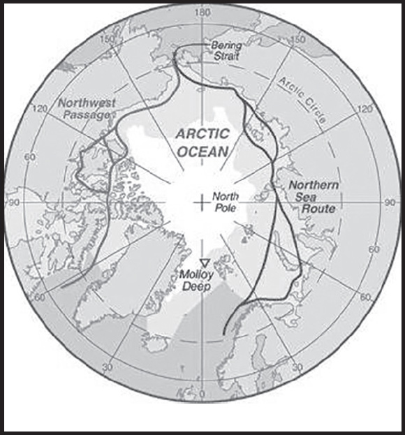
INTRODUCTION
Background: The Arctic Ocean is the smallest of the world’s five oceans (after the Pacific Ocean, Atlantic Ocean, Indian Ocean, and the Southern Ocean). The Northwest Passage (US and Canada) and Northern Sea Route (Norway and Russia) are two important seasonal waterways. In recent years the polar ice pack has receded in the summer allowing for increased navigation and raising the possibility of future sovereignty and shipping disputes among the six countries bordering the Arctic Ocean (Canada, Denmark (Greenland), Iceland, Norway, Russia, US).
GEOGRAPHY
Location: body of water between Europe, Asia, and North America, mostly north of the Arctic Circle
Geographic coordinates: 90 00 N, 0 00 E
Map references: Arctic Region
Area: total: 15.558 million sq km
note: includes Barents Sea, Beaufort Sea, Chukchi Sea, East Siberian Sea, Greenland Sea, Kara Sea, Laptev Sea, Northwest Passage, Norwegian Sea, and other tributary water bodies
Area - comparative: slightly less than 1.5 times the size of the US
Coastline: 45,389 km
Climate: polar climate characterized by persistent cold and relatively narrow annual temperature range; winters characterized by continuous darkness, cold and stable weather conditions, and clear skies; summers characterized by continuous daylight, damp and foggy weather, and weak cyclones with rain or snow
Ocean volume: ocean volume: 18.75 million cu km
percent of World Ocean total volume: 1.4%
Major ocean currents: two major, slow-moving, wind-driven currents (drift streams) dominate: a clockwise drift pattern in the Beaufort Gyre in the western part of the Arctic Ocean and a nearly straight line Transpolar Drift Stream that moves eastward across the ocean from the New Siberian Islands (Russia) to the Fram Strait (between Greenland and Svalbard); sea ice that lies close to the center of the gyre can complete a 360 degree circle in about 2 years, while ice on the gyre periphery will complete the same circle in about 7-8 years; sea ice in the Transpolar Drift crosses the ocean in about 3 years
Elevation: highest point: sea level
lowest point: Molloy Deep -5,577 m
mean depth: -1,205 m
ocean zones: Composed of water and in a fluid state, the oceans are delimited differently than the solid continents. Oceans are divided into three zones based on depth and light level. Although some sea creatures depend on light to live, others can do without it. Sunlight entering the water may travel about 1,000 m into the oceans under the right conditions, but there is rarely any significant light beyond 200 m.
The upper 200 m (656 ft) of oceans is called the euphotic, or “sunlight,” zone. This zone contains the vast majority of commercial fisheries and is home to many protected marine mammals and sea turtles. Only a small amount of light penetrates beyond this depth.
The zone between 200 m (656 ft) and 1,000 m (3,280 ft) is usually referred to as the “twilight” zone, but is officially the dysphotic zone. In this zone, the intensity of light rapidly dissipates as depth increases. Such a minuscule amount of light penetrates beyond a depth of 200 m that photosynthesis is no longer possible.
The aphotic, or “midnight,” zone exists in depths below 1,000 m (3,280 ft). Sunlight does not penetrate to these depths and the zone is bathed in darkness.
Distance Sunlight Travels in the Ocean:
Natural resources: sand and gravel aggregates, placer deposits, polymetallic nodules, oil and gas fields, fish, marine mammals (seals and whales)
Natural hazards: ice islands occasionally break away from northern Ellesmere Island; icebergs calved from glaciers in western Greenland and extreme northeastern Canada; permafrost in islands; virtually ice locked from October to June; ships subject to superstructure icing from October to May
Geography - note: major chokepoint is the southern Chukchi Sea (northern access to the Pacific Ocean via the Bering Strait); strategic location between North America and Russia; shortest marine link between the extremes of eastern and western Russia; floating research stations operated by the US and Russia; maximum snow cover in March or April about 20 to 50 centimeters over the frozen ocean; snow cover lasts about 10 months
ENVIRONMENT
Environment - current issues: climate change; changes in biodiversity; water pollution from use of toxic chemicals; endangered marine species include walruses and whales; fragile ecosystem slow to change and slow to recover from disruptions or damage; thinning polar icepack
Climate: polar climate characterized by persistent cold and relatively narrow annual temperature range; winters characterized by continuous darkness, cold and stable weather conditions, and clear skies; summers characterized by continuous daylight, damp and foggy weather, and weak cyclones with rain or snow
Marine fisheries: the Arctic fishery region (Region 18) is the smallest in the world with a catch of only 708 mt in 2019, although the Food and Agriculture Organization assesses that some Arctic catches are reported in adjacent regions; Russia and Canada were historically the major producers; in 2017, Canada, Denmark (Greenland), Iceland, Norway, Russia, and the US, along with the People’s Republic of China, the European Union, Japan, and the Republic of Korea, agreed to a 16 year ban on fishing in the Central Arctic Ocean to allow for time to study the ecological system of these waters
Regional fisheries bodies: International Council for the Exploration of the Seas
GOVERNMENT
Country name: etymology: the name Arctic comes from the Greek word “arktikos” meaning “near the bear” or “northern,” and that word derives from “arktos,” meaning “bear”; the name refers either to the constellation Ursa Major, the “Great Bear,” which is prominent in the northern celestial sphere, or to the constellation Ursa Minor, the “Little Bear,” which contains Polaris, the North (Pole) Star
TRANSPORTATION
Icebreakers: Norway: one PC 3 or 4 class medium icebreaker, and one PC 5 or 6 class light icebreaker
Russia: seven PC 1 or 2 class heavy icebreakers, eight PC 3 or 4 class medium icebreakers, and three PC 5 or 6 class light icebreakers
note: the ships are listed by Polar Class (PC) vessel: PC 1 - year-round operation in all polar waters (ice thickness >3 m); PC 2 - year-round operation in moderate multi-year ice conditions (ice thickness up to 3 m); PC 3 - year-round operation in second-year ice which may include multi-year ice inclusions (ice thickness up to 2.5 m); PC 4 - year-round operation in thick first-year ice which may include old ice inclusions (ice thickness up to 120 cm); PC 5 - year-round operation in medium first-year ice which may include old ice inclusions (ice thickness up to 70-120 cm); PC 6 - summer/autumn operation in medium first-year ice which may include old ice inclusions (ice thickness up to 30-70 cm)
Ports and terminals: major seaport(s): Churchill (Canada), Murmansk (Russia), Prudhoe Bay (US)
Transportation - note: sparse network of air, ocean, river, and land routes; the Northwest Passage (North America) and Northern Sea Route (Eurasia) are important seasonal waterways
TRANSNATIONAL ISSUES
Disputes - international: record summer melting of sea ice in the Arctic has renewed interest in maritime shipping lanes and sea floor exploration
Canada-US: dispute how to divide the Beaufort Sea and the status of the Northwest Passage but continue to work cooperatively to survey the Arctic continental shelf
Canada-Denmark (Greenland)-Norway: have made submissions to the UN Commission on the Limits of the Continental shelf (CLCS)
Norway-Russia: signed a comprehensive maritime boundary agreement in 2010; Russia has augmented its 2001 CLCS submission
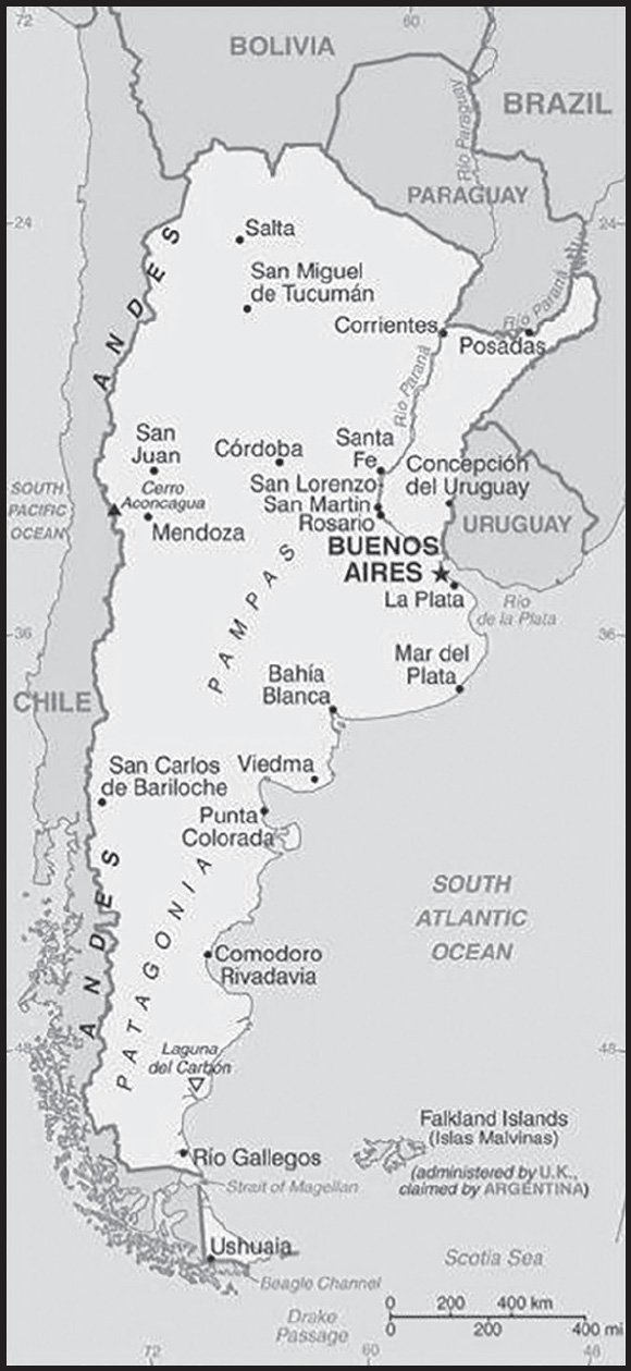
INTRODUCTION
Background: In 1816, the United Provinces of the Río de la Plata declared their independence from Spain. After Bolivia, Paraguay, and Uruguay went their separate ways, the area that remained became Argentina. The country’s population and culture were heavily shaped by immigrants from throughout Europe, with Italy and Spain providing the largest percentage of newcomers from 1860 to 1930. Up until about the mid-20th century, much of Argentina’s history was dominated by periods of internal political unrest and conflict between civilian and military factions.
After World War II, an era of populism under former President Juan Domingo PERÓN - the founder of the Peronist political movement - and direct and indirect military interference in subsequent governments was followed by a military junta that took power in 1976. Democracy returned in 1983 after a failed bid to seize the Falkland Islands (Islas Malvinas) by force, and has persisted despite numerous challenges, the most formidable of which was a severe economic crisis in 2001-02 that led to violent public protests and the successive resignations of several presidents. The years 2003-15 saw Peronist rule by Néstor KIRCHNER (2003-07) and his spouse Cristina FERNÁNDEZ DE KIRCHNER (2007-15), who oversaw several years of strong economic growth (2003-11) followed by a gradual deterioration in the government’s fiscal situation and eventual economic stagnation and isolation. Argentina underwent a brief period of economic reform and international reintegration under Mauricio MACRI (2015-19), but a recession in 2018-19 and frustration with MACRI’s economic policies ushered in a new Peronist government in 2019 led by President Alberto FERNÁNDEZ and Vice President FERNÁNDEZ DE KIRCHNER. Presidential elections will take place next in October 2023.
GEOGRAPHY
Location: Southern South America, bordering the South Atlantic Ocean, between Chile and Uruguay
Geographic coordinates: 34 00 S, 64 00 W
Map references: South America
Area: total: 2,780,400 sq km
land: 2,736,690 sq km
water: 43,710 sq km
comparison ranking: total 9
Area - comparative: slightly less than three-tenths the size of the US
Land boundaries: total: 11,968 km
border countries (5): Bolivia 942 km; Brazil 1,263 km; Chile 6,691 km; Paraguay 2,531 km; Uruguay 541 km
Coastline: 4,989 km
Maritime claims: territorial sea: 12 nm
contiguous zone: 24 nm
exclusive economic zone: 200 nm
continental shelf: 200 nm or to the edge of the continental margin
Climate: mostly temperate; arid in southeast; subantarctic in southwest
Terrain: rich plains of the Pampas in northern half, flat to rolling plateau of Patagonia in south, rugged Andes along western border
Elevation: highest point: Cerro Aconcagua (located in the northwestern corner of the province of Mendoza; highest point in South America) 6,962 m
lowest point: Laguna del Carbón (located between Puerto San Julián and Comandante Luis Piedra Buena in the province of Santa Cruz) -105 m
mean elevation: 595 m
Natural resources: fertile plains of the pampas, lead, zinc, tin, copper, iron ore, manganese, petroleum, uranium, arable land
Land use: agricultural land: 53.9% (2018 est.)
arable land: 13.9% (2018 est.)
permanent crops: 0.4% (2018 est.)
permanent pasture: 39.6% (2018 est.)
forest: 10.7% (2018 est.)
other: 35.4% (2018 est.)
Irrigated land: 23,600 sq km (2012)
Major lakes (area sq km): fresh water lake(s): Lago Buenos Aires (shared with Chile) - 2,240 sq km; Lago Argentino - 1,410 sq km; Lago Viedma - 1,090 sq km; Lago San Martín (shared with Chile) - 1,010 sq km; Lago Colhué Huapi - 800 sq km; Lago Fagnano (shared with Chile) - 590 sq km; Lago Nahuel Huapi - 550 sq km
salt water lake(s): Laguna Mar Chiquita - 1,850 sq km;
Major rivers (by length in km): Río de la Plata/Paraná river mouth (shared with Brazil [s], Paraguay, and Uruguay) - 4,880 km; Paraguay (shared with Brazil [s], and Paraguay [m]) - 2,549 km; Uruguay (shared with Brazil [s] and Uruguay [m]) - 1,610 km
note – [s] after country name indicates river source; [m] after country name indicates river mouth
Major watersheds (area sq km): Atlantic Ocean drainage: Paraná (2,582,704 sq km)
Major aquifers: Guaraní Aquifer System
Population distribution: one-third of the population lives in Buenos Aires; pockets of agglomeration occur throughout the northern and central parts of the country; Patagonia to the south remains sparsely populated
Natural hazards: San Miguel de Tucumán and Mendoza areas in the Andes subject to earthquakes; pamperos are violent windstorms that can strike the pampas and northeast; heavy flooding in some areas
volcanism: volcanic activity in the Andes Mountains along the Chilean border; Copahue (2,997 m) last erupted in 2000; other historically active volcanoes include Llullaillaco, Maipo, Planchón-Peteroa, San José, Tromen, Tupungatito, and Viedma
Geography - note: note 1: second-largest country in South America (after Brazil); strategic location relative to sea lanes between the South Atlantic and the South Pacific Oceans (Strait of Magellan, Beagle Channel, Drake Passage); diverse geophysical landscapes range from tropical climates in the north to tundra in the far south; Cerro Aconcagua is the Western Hemisphere’s tallest mountain, while Laguna del Carbón is the lowest point in the Western Hemisphere; shares Iguazú Falls, the world’s largest waterfalls system, with Brazil
note 2: southeast Bolivia and northwest Argentina seem to be the original development site for peanuts
PEOPLE AND SOCIETY
Population: 46,621,847 (2023 est.)
comparison ranking: 33
Nationality: noun: Argentine(s)
adjective: Argentine
Ethnic groups: European (mostly Spanish and Italian descent) and Mestizo (mixed European and Amerindian ancestry) 97.2%, Amerindian 2.4%, African descent 0.4% (2010 est.)
Languages: Spanish (official), Italian, English, German, French, indigenous (Quechua, Guarani, Mapudungun)
major-language sample(s): La Libreta Informativa del Mundo, la fuente indispensable de información básica. (Spanish)
Religions: Roman Catholic 62.9%, Evangelical 15.3% (Pentecostal 13%, other Evangelical 2.3%), Jehovah’s Witness and Church of Jesus Christ 1.4%, other 1.2% (includes Muslim, Jewish), none 18.9% (includes agnostic and atheist), unspecified 0.3% (2019 est.)
Demographic profile: Argentina’s population continues to grow but at a slower rate because of its steadily declining birth rate. Argentina’s fertility decline began earlier than in the rest of Latin America, occurring most rapidly between the early 20th century and the 1950s, and then becoming more gradual. Life expectancy has been improving, most notably among the young and the poor. While the population under age 15 is shrinking, the youth cohort - ages 15-24 - is the largest in Argentina’s history and will continue to bolster the working-age population. If this large working-age population is well-educated and gainfully employed, Argentina is likely to experience an economic boost and possibly higher per capita savings and investment. Although literacy and primary school enrollment are nearly universal, grade repetition is problematic and secondary school completion is low. Both of these issues vary widely by region and socioeconomic group.
Argentina has been primarily a country of immigration for most of its history, welcoming European immigrants (often providing needed low-skilled labor) after its independence in the 19th century and attracting especially large numbers from Spain and Italy. More than 7 million European immigrants are estimated to have arrived in Argentina between 1880 and 1930, when it adopted a more restrictive immigration policy. European immigration also began to wane in the 1930s because of the global depression. The inflow rebounded temporarily following WWII and resumed its decline in the 1950s when Argentina’s military dictators tightened immigration rules and European economies rebounded. Regional migration increased, however, supplying low-skilled workers escaping economic and political instability in their home countries. As of 2015, immigrants made up almost 5% of Argentina’s population, the largest share in South America. Migration from neighboring countries accounted for approximately 80% of Argentina’s immigrant population in 2015.
The first waves of highly skilled Argentine emigrant workers headed mainly to the United States and Spain in the 1960s and 1970s, driven by economic decline and repressive military dictatorships. The 2008 European economic crisis drove the return migration of some Argentinean and other Latin American nationals, as well as the immigration of Europeans to South America, where Argentina was a key recipient. In 2015, Argentina received the highest number of legal migrants in Latin America and the Caribbean. The majority of its migrant inflow came from Paraguay and Bolivia.
Age structure: 0-14 years: 23.51% (male 5,645,070/female 5,316,156)
15-64 years: 63.83% (male 14,929,084/female 14,827,733)
65 years and over: 12.66% (2023 est.) (male 2,511,984/female 3,391,820)
Dependency ratios: total dependency ratio: 54.3
youth dependency ratio: 36
elderly dependency ratio: 18.2
potential support ratio: 5.5 (2021 est.)
Median age: total: 32.4 years (2020)
male: 31.1 years
female: 33.6 years
comparison ranking: total 110
Population growth rate: 0.8% (2023 est.)
comparison ranking: 113
Birth rate: 15.38 births/1,000 population (2023 est.)
comparison ranking: 105
Death rate: 7.28 deaths/1,000 population (2023 est.)
comparison ranking: 111
Net migration rate: -0.08 migrant(s)/1,000 population (2023 est.)
comparison ranking: 102
Population distribution: one-third of the population lives in Buenos Aires; pockets of agglomeration occur throughout the northern and central parts of the country; Patagonia to the south remains sparsely populated
Urbanization: urban population: 92.5% of total population (2023)
rate of urbanization: 0.97% annual rate of change (2020-25 est.)
Major urban areas - population: 15.490 million BUENOS AIRES (capital), 1.612 million Córdoba, 1.594 million Rosario, 1.226 million Mendoza, 1.027 million San Miguel de Tucumán, 914,000 La Plata (2023)
Sex ratio: at birth: 1.07 male(s)/female
0-14 years: 1.06 male(s)/female
15-64 years: 1.01 male(s)/female
65 years and over: 0.74 male(s)/female
total population: 0.98 male(s)/female (2023 est.)
Maternal mortality ratio: 45 deaths/100,000 live births (2020 est.)
comparison ranking: 98
Infant mortality rate: total: 9.14 deaths/1,000 live births (2023 est.)
male: 10.13 deaths/1,000 live births
female: 8.09 deaths/1,000 live births
comparison ranking: total 141
Life expectancy at birth: total population: 78.55 years (2023 est.)
male: 75.49 years
female: 81.81 years
comparison ranking: total population 75
Total fertility rate: 2.17 children born/woman (2023 est.)
comparison ranking: 88
Gross reproduction rate: 1.05 (2023 est.)
Contraceptive prevalence rate: 70.1% (2019/20)
Drinking water source: improved: urban: 99.8% of population
unimproved: urban: 0.2% of population
Current health expenditure: 10% of GDP (2020)
Physicians density: 4.06 physicians/1,000 population (2020)
Hospital bed density: 5 beds/1,000 population (2017)
Sanitation facility access: improved: urban: 100% of population
Obesity - adult prevalence rate: 28.3% (2016)
comparison ranking: 31
Alcohol consumption per capita: total: 7.95 liters of pure alcohol (2019 est.)
beer: 3.62 liters of pure alcohol (2019 est.)
wine: 2.88 liters of pure alcohol (2019 est.)
spirits: 0.72 liters of pure alcohol (2019 est.)
other alcohols: 0.72 liters of pure alcohol (2019 est.)
comparison ranking: total 45
Tobacco use: total: 24.5% (2020 est.)
male: 29.4% (2020 est.)
female: 19.6% (2020 est.)
comparison ranking: total 53
Children under the age of 5 years underweight: 1.7% (2018/19)
comparison ranking: 111
Currently married women (ages 15-49): 48.9% (2023 est.)
Child marriage: women married by age 15: 2.4%
women married by age 18: 15.5% (2020 est.)
Education expenditures: 5% of GDP (2020 est.)
comparison ranking: 79
Literacy: definition: age 15 and over can read and write
total population: 99%
male: 98.9%
female: 99.1% (2018)
School life expectancy (primary to tertiary education): total: 18 years
male: 17 years
female: 20 years (2020)
Youth unemployment rate (ages 15-24): total: 29.9% (2021 est.)
male: 25%
female: 37.1%
comparison ranking: total 41
ENVIRONMENT
Environment - current issues: environmental problems (urban and rural) typical of an industrializing economy such as deforestation, soil degradation (erosion, salinization), desertification, air pollution, and water pollution
Environment - international agreements: party to: Antarctic-Environmental Protection, Antarctic-Marine Living Resources, Antarctic Seals, Antarctic Treaty, Biodiversity, Climate Change, Climate Change-Kyoto Protocol, Climate Change-Paris Agreement, Comprehensive Nuclear Test Ban, Desertification, Endangered Species, Environmental Modification, Hazardous Wastes, Law of the Sea, Marine Dumping-London Convention, Nuclear Test Ban, Ozone Layer Protection, Ship Pollution, Wetlands, Whaling
signed, but not ratified: Marine Dumping-London Protocol, Marine Life Conservation
Climate: mostly temperate; arid in southeast; subantarctic in southwest
Land use: agricultural land: 53.9% (2018 est.)
arable land: 13.9% (2018 est.)
permanent crops: 0.4% (2018 est.)
permanent pasture: 39.6% (2018 est.)
forest: 10.7% (2018 est.)
other: 35.4% (2018 est.)
Urbanization: urban population: 92.5% of total population (2023)
rate of urbanization: 0.97% annual rate of change (2020-25 est.)
Revenue from forest resources: 0.09% of GDP (2018 est.)
comparison ranking: 115
Revenue from coal: 0% of GDP (2018 est.)
comparison ranking: 72
Air pollutants: particulate matter emissions: 12.04 micrograms per cubic meter (2019 est.)
carbon dioxide emissions: 201.35 megatons (2016 est.)
methane emissions: 120.66 megatons (2020 est.)
Waste and recycling: municipal solid waste generated annually: 17,910,550 tons (2014 est.)
municipal solid waste recycled annually: 1,074,633 tons (2010 est.)
percent of municipal solid waste recycled: 6% (2010 est.)
Major lakes (area sq km): fresh water lake(s): Lago Buenos Aires (shared with Chile) - 2,240 sq km; Lago Argentino - 1,410 sq km; Lago Viedma - 1,090 sq km; Lago San Martín (shared with Chile) - 1,010 sq km; Lago Colhué Huapi - 800 sq km; Lago Fagnano (shared with Chile) - 590 sq km; Lago Nahuel Huapi - 550 sq km
salt water lake(s): Laguna Mar Chiquita - 1,850 sq km;
Major rivers (by length in km): Río de la Plata/Paraná river mouth (shared with Brazil [s], Paraguay, and Uruguay) - 4,880 km; Paraguay (shared with Brazil [s], and Paraguay [m]) - 2,549 km; Uruguay (shared with Brazil [s] and Uruguay [m]) - 1,610 km
note – [s] after country name indicates river source; [m] after country name indicates river mouth
Major watersheds (area sq km): Atlantic Ocean drainage: Paraná (2,582,704 sq km)
Major aquifers: Guaraní Aquifer System
Total water withdrawal: municipal: 5.85 billion cubic meters (2020 est.)
industrial: 4 billion cubic meters (2020 est.)
agricultural: 27.93 billion cubic meters (2020 est.)
Total renewable water resources: 876.24 billion cubic meters (2020 est.)
GOVERNMENT
Country name: conventional long form: Argentine Republic
conventional short form: Argentina
local long form: República Argentina
local short form: Argentina
etymology: originally the area was referred to as Tierra Argentina, i.e., “Land beside the Silvery River” or “silvery land,” which referred to the massive estuary in the east of the country, the Río de la Plata (River of Silver); over time the name shortened to simply Argentina or “silvery”
Government type: presidential republic
Capital: name: Buenos Aires
geographic coordinates: 34 36 S, 58 22 W
time difference: UTC-3 (2 hours ahead of Washington, DC, during Standard Time)
etymology: the name translates as “fair winds” in Spanish and derives from the original designation of the settlement that would become the present-day city, “Santa Maria del Buen Aire” (Saint Mary of the Fair Winds)
Administrative divisions: 23 provinces (provincias, singular - provincia) and 1 autonomous city*; Buenos Aires, Catamarca, Chaco, Chubut, Ciudad Autonoma de Buenos Aires*, Cordoba, Corrientes, Entre Rios, Formosa, Jujuy, La Pampa, La Rioja, Mendoza, Misiones, Neuquen, Rio Negro, Salta, San Juan, San Luis, Santa Cruz, Santa Fe, Santiago del Estero, Tierra del Fuego - Antartida e Islas del Atlantico Sur (Tierra del Fuego - Antarctica and the South Atlantic Islands), Tucuman
note: the US does not recognize any claims to Antarctica
Independence: 9 July 1816 (from Spain)
National holiday: Revolution Day (May Revolution Day), 25 May (1810)
Constitution: history: several previous; latest effective 11 May 1853
amendments: a declaration of proposed amendments requires two-thirds majority vote by both houses of the National Congress followed by approval by an ad hoc, multi-member constitutional convention; amended several times, last significant amendment in 1994
Legal system: civil law system based on West European legal systems; note - in mid-2015, Argentina adopted a new civil code, replacing the old one in force since 1871
International law organization participation: has not submitted an ICJ jurisdiction declaration; accepts ICCt jurisdiction
Citizenship: citizenship by birth: yes
citizenship by descent only: yes
dual citizenship recognized: yes
residency requirement for naturalization: 2 years
Suffrage: 18-70 years of age; universal and compulsory; 16-17 years of age - optional for national elections
Executive branch: chief of state: President Alberto Ángel FERNÁNDEZ (since 10 December 2019); Vice President Cristina FERNÁNDEZ DE KIRCHNER (since 10 December 2019); note - the president is both chief of state and head of government
head of government: President Alberto Ángel FERNÁNDEZ (since 10 December 2019); Vice President Cristina FERNÁNDEZ DE KIRCHNER (since 10 December 2019)
cabinet: Cabinet appointed by the president
elections/appointments: president and vice president directly elected on the same ballot by qualified majority vote (to win, a candidate must receive at least 45% of votes or 40% of votes and a 10-point lead over the second place candidate; if neither occurs, a second round is held); the president serves a 4-year term (eligible for a second consecutive term); election last held on 22 October 2023, with a runoff to be held 19 November 2023 (next to be held in October 2027)
election results: 2023: percent vote in first round - Sergio Tomás MASSA (FR) 36.7%, Javier Gerardo MILEI (PL) 30%, Patricia BULLRICH 23.8% (JxC/PRO), Juan SCHIARETTI (PJ) 6.8%, Myriam BREGMAN (PTS) 2.7%; MASSA and MILEI advance to a runoff election scheduled for 19 November 2023
2019: Alberto Ángel FERNÁNDEZ elected president; percent of vote - Alberto Angel FERNÁNDEZ (TODOS) 48.1%, Mauricio MACRI (PRO) 40.4%, Roberto LAVAGNA (independent) 6.2%, other 5.3%
2015: Mauricio MACRI elected president in second round; percent of vote in first round - Daniel SCIOLI (PJ) 37.1%, Mauricio MACRI (PRO) 34.2%, Sergio MASSA (FR/PJ) 21.4%, other 7.3%; percent of vote in second round - Mauricio MACRI 51.4%, Daniel SCIOLI 48.6%
Legislative branch: description: bicameral National Congress or Congreso Nacional consists of:
Senate or Senado (72 seats; members directly elected from 24 provincial districts by closed-list proportional representation vote; 2 seats per district awarded to the party with the most votes and 1 seat per district to the party with the second highest votes; members serve 6-year terms with one-third of the membership renewed every 2 years) Chamber of Deputies or Cámara de Diputados (257 seats; members directly elected in multi-seat constituencies by closed-list proportional representation vote; members serve 4-year terms with one-half of the membership renewed every 2 years)
elections: Senate - last held on 22 October 2023 (next to be held in October 2025)
Chamber of Deputies - last held on 22 October 2023 (next to be held in October 2025)
election results: Senate - percent of vote by bloc or party - NA; seats by bloc or party - UP 12, LLA 8, JxC 2, other 2; composition (as of February 2022) men 41, women 31, percent of women 43.1%
Chamber of Deputies - percent of vote by bloc or party - NA; seats by bloc or party - UP 58, LLA 35, JxC 31, NHP 4, other 2; composition (as of February 2022) - men 142, women 115, percent of women 44.7%; note - total National Congress percent of women 44.4%
Judicial branch: highest court(s): Supreme Court or Corte Suprema (consists of the court president, vice president, 2 judges, 1 vacancy)
judge selection and term of office: judges nominated by the president and approved by the Senate; ministers can serve until mandatory retirement at age 75; extensions beyond 75 require renomination by the president and approval by the Senate
subordinate courts: federal level appellate, district, and territorial courts; provincial level supreme, appellate, and first instance courts
Political parties and leaders: Avanza Libertad or AL [José Luis ESPERT]
Civic Coalition ARI or CC-ARI [Elisa CARRIÓ, Maximiliano FERRARO]
Consenso Federal (Federal Consensus) or CF [Roberto LAVAGNA, Juan Manuel URTUBEY]
Frente Cívico por Santiago (Civic Front for Santiago) [Gerardo ZAMORA]
Frente de Izquierda y de los Trabajadores - Unidad (Workers’ Left Front) or FIT-U [Nicolás DEL CAÑO, Miriam BREGMAN] (coalition of leftist parties in lower house; includes PTS, PO, and MST)
Frente de la Concordia Misionero (Front for the Renewal of Social Concord) or FRCS [Carlos Eduardo ROVIRA]
Frente Renovador (Renewal Front) or FR [Sergio MASSA, Pablo MIROLO]
Generación por un Encuentro Nacional (Generation for a National Encounter) or GEN [Margarita STOLBIZER]
Hacemos por Córdoba (We do for Cordoba) or HC [Juan SCHIARETTI]
Hacemos por Nuestro Pais (We Do For Our Country) or NHP [Juan SCHIARETTI]
Juntos por el Cambio (Together for Change) or JxC [Patricia BULLRICH, Horacio Rodríguez LARRETA, Mauricio MACRI] (includes CC-ARI, PRO, and UCR); note - primary opposition coalition since 2019
Juntos Somos Río Negro (Together We Are Rio Negro) or JSRN [Alberto WERETILNECK]
Partido Justicialista (Justicialist Party) or PJ [Alberto Angel FERNÁNDEZ]
La Cámpora [Maximo KIRCHNER]
La Libertad Avanza (The Liberty Advances) or LLA [Javier MILEI]
Movimiento Popular Neuquino (Neuquén People’s Movement) or MPN [Omar GUTIÉRREZ]
Movimiento Socialista de los Trabajadores (Workers’ Socialist Movement) or MST [Vilma RIPOLL, Alejandro BODART]
Partido de los Trabajadores Socialistas (Socialist Workers’ Party) or PTS [Nicolás DEL CAÑO]
Partido Libertario (Libertarian Party) or PL [Javier MILEI]; note - party is also a founding member of the coalition La Libertad Avanza, which is also led by MILEI
Partido Obrero (Workers’ Party) or PO [Gabriel SOLANO]
Partido Socialista or PS [Mónica Haydée FEIN]
Propuesta Republicana (Republican Proposal) or PRO [Mauricio MACRI]
Unidad Federal (coalition of provencial parties in the lower house; includes FRCS and JSRN)
Unión Cívica Radical (Radical Civic Union) or UCR [Gerardo Rubén MORALES]
Unión por la Patria (Union for the Homeland) or UP (formerly Frente de Todos (Everyone’s Front) or FdT) [Alberto FERNÁNDEZ, Cristina FERNÁNDEZ DE KIRCHNER] (includes FR, La Cámpora, and PJ); note - ruling coalition since 2019; includes several national and provincial Peronist political parties
Vamos con Vos (Let’s Go with You) or VcV [Florencio RANDAZZO]
International organization participation: AfDB (nonregional member), Australia Group, BCIE, BIS, CAN (associate), CD, CELAC, FAO, FATF, G-15, G-20, G-24, G-77, IADB, IAEA, IBRD, ICAO, ICC (national committees), ICCt, ICRM, IDA, IFAD, IFC, IFRCS, IHO, ILO, IMF, IMO, IMSO, Interpol, IOC, IOM, IPU, ISO, ITSO, ITU, ITUC (NGOs), LAES, LAIA, Mercosur, MIGA, MINURSO, MINUSTAH, NAM (observer), NSG, OAS, OPANAL, OPCW, Paris Club (associate), PCA, PROSUR, SICA (observer), UN, UNASUR, UNCTAD, UNDOF, UNESCO, UNFICYP, UNHCR, UNHRC, UNIDO, Union Latina (observer), UNOOSA, UNTSO, UNWTO, UPU, Wassenaar Arrangement, WCO, WFTU (NGOs), WHO, WIPO, WMO, WTO, ZC
Diplomatic representation in the US: chief of mission: Ambassador Jorge Martin Arturo ARGUELLO (since 6 February 2020)
chancery: 1600 New Hampshire Avenue NW, Washington, DC 20009
telephone: [1] (202) 238-6400
FAX: [1] (202) 332-3171
email address and website: eeeuu@mrecic.gov.ar
https://eeeuu.cancilleria.gob.ar/en
consulate(s) general: Atlanta, Chicago, Houston, Los Angeles, Miami, New York, Washington, DC
Diplomatic representation from the US: chief of mission: Ambassador Marc Robert STANLEY (since 24 January 2022)
embassy: Avenida Colombia 4300, (C1425GMN) Buenos Aires
mailing address: 3130 Buenos Aires Place, Washington DC 20521-3130
telephone: [54] (11) 5777-4533
FAX: [54] (11) 5777-4240
email address and website: buenosaires-acs@state.gov
Flag description: three equal horizontal bands of sky blue (top), white, and sky blue; centered in the white band is a radiant yellow sun with a human face (delineated in brown) known as the Sun of May; the colors represent the clear skies and snow of the Andes; the sun symbol commemorates the appearance of the sun through cloudy skies on 25 May 1810 during the first mass demonstration in favor of independence; the sun features are those of Inti, the Inca god of the sun
National symbol(s): Sun of May (a sun-with-face symbol); national colors: sky blue, white
National anthem: name: “Himno Nacional Argentino” (Argentine National Anthem)
lyrics/music: Vicente LOPEZ y PLANES/Jose Blas PARERA
note: adopted 1813; Vicente LOPEZ was inspired to write the anthem after watching a play about the 1810 May Revolution against Spain
National heritage: total World Heritage Sites: 11 (6 cultural, 5 natural)
selected World Heritage Site locales: Los Glaciares National Park (n); Jesuit Missions of the Guaranis (c); Iguazú National Park (n); Cueva de las Manos (c); Valdés Península (n); Ischigualasto/Talampaya National Parks (n); Jesuit Block and Estancias of Córdoba (c); Quebrada de Humahuaca (c); Qhapaq Ñan/Andean Road System (c)
ECONOMY
Economic overview: large diversified economy; financial risks from debt obligations, rapid inflation, and reduced investor appetites; resourcerich, export-led growth model; increasing trade relations with China; G20 and OAS leader; tendency to nationalize businesses and under-report inflation
Real GDP (purchasing power parity): $986.134 billion (2021 est.)
$893.251 billion (2020 est.)
$991.876 billion (2019 est.)
note: data are in 2017 dollars
comparison ranking: 29
Real GDP growth rate: 10.4% (2021 est.)
-9.94% (2020 est.)
-2% (2019 est.)
comparison ranking: 27
Real GDP per capita: $21,500 (2021 est.)
$19,700 (2020 est.)
$22,100 (2019 est.)
note: data are in 2017 dollars
comparison ranking: 86
GDP (official exchange rate): $447.467 billion (2019 est.)
Inflation rate (consumer prices): 25.7% (2017 est.)
26.5% (2016 est.)
note: data are derived from private estimates
comparison ranking: 12
Credit ratings: Fitch rating: CCC (2020)
Moody’s rating: Ca (2020)
Standard & Poors rating: CCC+ (2020)
note: The year refers to the year in which the current credit rating was first obtained.
GDP - composition, by sector of origin: agriculture: 10.8% (2017 est.)
industry: 28.1% (2017 est.)
services: 61.1% (2017 est.)
comparison rankings: services 114; industry 94; agriculture 86
GDP - composition, by end use: household consumption: 65.9% (2017 est.)
government consumption: 18.2% (2017 est.)
investment in fixed capital: 14.8% (2017 est.)
investment in inventories: 3.7% (2017 est.)
exports of goods and services: 11.2% (2017 est.)
imports of goods and services: -13.8% (2017 est.)
Agricultural products: maize, soybeans, wheat, sugar cane, milk, barley, sunflower seed, beef, grapes, potatoes
Industries: food processing, motor vehicles, consumer durables, textiles, chemicals and petrochemicals, printing, metallurgy, steel
Industrial production growth rate: 15.26% (2021 est.)
note: based on private sector estimates
comparison ranking: 16
Labor force: 21.206 million (2021 est.)
note: urban areas only
comparison ranking: 31
Labor force - by occupation: agriculture: 5.3%
industry: 28.6%
services: 66.1% (2017 est.)
Unemployment rate: 10.9% (2021 est.)
11.46% (2020 est.)
9.84% (2019 est.)
comparison ranking: 65
Youth unemployment rate (ages 15-24): total: 29.9% (2021 est.)
male: 25%
female: 37.1%
comparison ranking: total 41
Population below poverty line: 35.5% (2019 est.)
Gini Index coefficient - distribution of family income: 42.3 (2020 est.)
comparison ranking: 41
Average household expenditures: on food: 28.3% of household expenditures (2018 est.)
on alcohol and tobacco: 1.9% of household expenditures (2018 est.)
Household income or consumption by percentage share: lowest 10%: 1.8%
highest 10%: 31% (2017 est.)
Budget: revenues: $150.823 billion (2019 est.)
expenditures: $170.725 billion (2019 est.)
Budget surplus (+) or deficit (-): -6% (of GDP) (2017 est.)
comparison ranking: 183
Public debt: 57.6% of GDP (2017 est.)
55% of GDP (2016 est.)
comparison ranking: 86
Taxes and other revenues: 10.87% (of GDP) (2020 est.)
comparison ranking: 188
Fiscal year: calendar year
Current account balance: $6.708 billion (2021 est.)
$3.121 billion (2020 est.)
-$3.492 billion (2019 est.)
comparison ranking: 31
Exports: $87.415 billion (2021 est.)
$64.431 billion (2020 est.)
$79.964 billion (2019 est.)
note: Data are in current year dollars and do not include illicit exports or re-exports.
comparison ranking: 49
Exports - partners: Brazil 16%, China 11%, United States 7%, Chile 5% (2019)
Exports - commodities: corn, soybean products, delivery trucks, wheat, beef, gold (2021)
Imports: $72.362 billion (2021 est.) note: data are in current year dollars
$52.339 billion (2020 est.) note: data are in current year dollars
$66.574 billion (2019 est.) note: data are in current year dollars
comparison ranking: 53
Imports - partners: Brazil 21%, China 18%, US 14%, Germany 6% (2019)
Imports - commodities: cars, refined petroleum, vehicle parts, natural gas, soybeans (2019)
Reserves of foreign exchange and gold: $39.653 billion (31 December 2021 est.)
$39.404 billion (31 December 2020 est.)
$44.881 billion (31 December 2019 est.)
comparison ranking: 51
Debt - external: $278.524 billion (2019 est.)
$261.949 billion (2018 est.)
comparison ranking: 33
Exchange rates: Argentine pesos (ARS) per US dollar -
Exchange rates: 94.991 (2021 est.)
70.539 (2020 est.)
48.148 (2019 est.)
28.095 (2018 est.)
16.563 (2017 est.)
ENERGY
Electricity access: electrification - total population: 100% (2021)
Electricity: installed generating capacity: 44.731 million kW (2020 est.)
consumption: 121,563,940,000 kWh (2020 est.)
exports: 261 million kWh (2020 est.)
imports: 7.802 billion kWh (2020 est.)
transmission/distribution losses: 20.74 billion kWh (2020 est.)
comparison rankings: transmission/distribution losses 21; imports 30; exports 83; consumption 31; installed generating capacity 27
Electricity generation sources: fossil fuels: 65.8% of total installed capacity (2020 est.)
nuclear: 7.3% of total installed capacity (2020 est.)
solar: 1% of total installed capacity (2020 est.)
wind: 6.8% of total installed capacity (2020 est.)
hydroelectricity: 17.6% of total installed capacity (2020 est.)
tide and wave: 0% of total installed capacity (2020 est.)
geothermal: 0% of total installed capacity (2020 est.)
biomass and waste: 1.5% of total installed capacity (2020 est.)
Nuclear energy: Number of operational nuclear reactors: 3 (2023)
Number of nuclear reactors under construction: 1
Net capacity of operational nuclear reactors: 1.64GW (2023)
Percent of total electricity production: 7.2% (2021)
Percent of total energy produced: 3.6% (2021)
Number of nuclear reactors permanently shut down: 0 Coal:
production: 829,000 metric tons (2020 est.)
consumption: 1.55 million metric tons (2020 est.)
exports: 4,000 metric tons (2020 est.)
imports: 990,000 metric tons (2020 est.)
proven reserves: 500 million metric tons (2019 est.)
Petroleum: total petroleum production: 690,200 bbl/day (2021 est.)
refined petroleum consumption: 680,000 bbl/day (2019 est.)
crude oil and lease condensate exports: 59,100 bbl/day (2018 est.)
crude oil and lease condensate imports: 11,400 bbl/day (2018 est.)
crude oil estimated reserves: 2,482,700,000 barrels (2021 est.)
Refined petroleum products - production: 669,800 bbl/day (2015 est.)
comparison ranking: 26
Refined petroleum products - exports: 58,360 bbl/day (2015 est.)
comparison ranking: 51
Refined petroleum products - imports: 121,400 bbl/day (2015 est.)
comparison ranking: 49
Natural gas: production: 41,194,148,000 cubic meters (2020 est.)
consumption: 49,476,585,000 cubic meters (2019 est.)
exports: 691.241 million cubic meters (2019 est.)
imports: 6,865,323,000 cubic meters (2019 est.)
proven reserves: 396.464 billion cubic meters (2021 est.)
Carbon dioxide emissions: 193.205 million metric tonnes of CO2 (2019 est.)
from coal and metallurgical coke: 2.122 million metric tonnes of CO2 (2019 est.)
from petroleum and other liquids: 94.208 million metric tonnes of CO2 (2019 est.)
from consumed natural gas: 96.875 million metric tonnes of CO2 (2019 est.)
comparison ranking: total emissions 32
Energy consumption per capita: 79.083 million Btu/person (2019 est.)
comparison ranking: 77
COMMUNICATIONS
Telephones - fixed lines: total subscriptions: 6,903,068 (2021 est.)
subscriptions per 100 inhabitants: 15 (2021 est.)
comparison ranking: total subscriptions 22
Telephones - mobile cellular: total subscriptions: 59,065,827 (2021 est.)
subscriptions per 100 inhabitants: 130 (2021 est.)
comparison ranking: total subscriptions 28
Telecommunication systems: general assessment: Argentina’s ongoing problem with hyperinflation continues to distort the telecom market’s performance, which shows strong growth in revenue but only modest gains in subscriber numbers each year; the fixed broadband segment has penetration levels only slightly higher than the fixed-line teledensity; nearly a quarter of the country’s broadband connections are via DSL, although fiber is starting claim an increasing share of that market as networks expand across most of the main cities; mobile broadband continues to be the preferred platform for internet access, supported by high mobile penetration levels and nationwide LTE coverage; the first 5G service was launched in February 2021 using refarmed LTE frequencies; the anticipated 5G spectrum auctions should drive even stronger uptake in mobile broadband services; while the various fixed, mobile, and cable operators push to expand and enhance their services, the government is also making an active contribution towards boosting broadband connectivity around the country; its national connectivity plan ‘Plan Conectar’, launched in September 2020, provides funding for a range of programs to increase coverage; in August 2021, the telecom regulator announced the release funding to help operators accelerate the rollout of their broadband infrastructure and services (2021)
domestic: roughly 15 per 100 fixed-line and 130 per 100 mobile-cellular; microwave radio relay, fiber-optic cable, and a domestic satellite system with 40 earth stations serve the trunk network (2021)
international: country code - 54; landing points for the UNISUR, Bicentenario, Atlantis-2, SAm-1, and SAC, Tannat, Malbec and ARBR submarine cable systems that provide links to Europe, Africa, South and Central America, and US; satellite earth stations - 112 (2019)
Broadcast media: government owns a TV station and radio network; more than two dozen TV stations and hundreds of privately owned radio stations; high rate of cable TV subscription usage (2022)
Internet country code: .ar
Internet users: total: 39.15 million (2021 est.)
percent of population: 87% (2021 est.)
comparison ranking: total 25
Broadband - fixed subscriptions: total: 9,571,562 (2020 est.)
subscriptions per 100 inhabitants: 21 (2020 est.)
comparison ranking: total 20
TRANSPORTATION
National air transport system: number of registered air carriers: 6 (2020)
inventory of registered aircraft operated by air carriers: 107
annual passenger traffic on registered air carriers: 18,081,937 (2018)
annual freight traffic on registered air carriers: 311.57 million (2018) mt-km
Civil aircraft registration country code prefix: LV
Airports: 916 (2021)
comparison ranking: total 6
Airports - with paved runways: 161
civil airports: 15
military airports: 5
joint use (civil-military) airports: 16
other airports: 125
note: paved runways have a concrete or asphalt surface but not all have facilities for refueling, maintenance, or air traffic control; the length of a runway required for aircraft to safely operate depends on a number of factors including the type of aircraft, the takeoff weight (including passengers, cargo, and fuel), engine types, flap settings, landing speed, elevation of the airport, and average maximum daily air temperature; paved runways can reach a length of 5,000 m (16,000 ft.), but the “typical” length of a commercial airline runway is between 2,500-4,000 m (8,000-13,000 ft.)
Airports - with unpaved runways: 977
note: unpaved runways have a surface composition such as grass or packed earth and are most suited to the operation of light aircraft; unpaved runways are usually short, often less than 1,000 m (3,280 ft.) in length; airports with unpaved runways often lack facilities for refueling, maintenance, or air traffic control
Heliports: 2 (2021)
Pipelines: 29,930 km gas, 41 km liquid petroleum gas, 6,248 km oil, 3,631 km refined products (2013)
Railways: total: 17,866 km (2018)
comparison ranking: total 16
Roadways: total: 281,290 km (2017)
paved: 117,616 km (2017)
unpaved: 163,674 km (2017)
comparison ranking: total 21
Waterways: 11,000 km (2012)
comparison ranking: 13
Merchant marine: total: 203 (2022)
by type: container ship 1, bulk carrier 1 general cargo 8, oil tanker 33, other 160
comparison ranking: total 64
Ports and terminals: major seaport(s): Bahia Blanca, Buenos Aires, La Plata, Punta Colorada, Ushuaia
container port(s) (TEUs): Buenos Aires (1,446,452) (2021)
LNG terminal(s) (import): Bahia Blanca
river port(s): Arroyo Seco, Rosario, San Lorenzo-San Martin (Parana)
Transportation - note: Argentina operates one PC 5 or 6 class light icebreaker
note - PC indicates a Polar Class vessel: PC 5 - year-round operation in medium first-year ice which may include old ice inclusions (ice thickness up to 70-120 cm); PC 6 - summer/autumn operation in medium first-year ice which may include old ice inclusions (ice thickness up to 30-70 cm)
MILITARY AND SECURITY
Military and security forces: Armed Forces of the Argentine Republic (Fuerzas Armadas de la República Argentina): Argentine Army (Ejercito Argentino, EA), Navy of the Argentine Republic (Armada Republica, ARA; includes naval aviation and naval infantry), Argentine Air Force (Fuerza Aerea Argentina, FAA)
Ministry of Security: Gendarmería Nacional Argentina (National Gendarmerie), Coast Guard (Prefectura Naval) (2023)
note: all federal police forces are under the Ministry of Security
Military expenditures: 0.6% of GDP (2022 est.)
0.8% of GDP (2021)
0.8% of GDP (2020)
0.7% of GDP (2019)
0.8% of GDP (2018)
comparison ranking: 156
Military and security service personnel strengths: approximately 80,000 active-duty personnel (50,000 Army; 17,000 Navy, including about 3,500 marines); 13,000 Air Force); estimated 20,000 Gendarmerie (2023)
Military equipment inventories and acquisitions: the inventory of Argentina’s armed forces is a mix of domestically-produced and mostly older imported weapons, largely from Europe and the US; in recent years, France and the US have been the leading suppliers of equipment; Argentina has an indigenous defense industry that produces air, land, and naval systems (2023)
Military service age and obligation: 18-24 years of age for voluntary military service for men and women; conscription suspended in 1995; citizens can still be drafted in times of crisis, national emergency, or war, or if the Defense Ministry is unable to fill all vacancies to keep the military functional (2023)
note: as of 2022, women comprised about 20% of the active duty military
Military deployments: 225 Cyprus (UNFICYP) (2023)
Military - note: the Argentine military’s primary responsibilities are territorial defense and protecting the country’s sovereignty, but its duties also include border security, countering narcotics trafficking, and other internal missions, such as disaster response and infrastructure development; it also conducts support operations in Antarctica to promote an active presence in areas of national territory that are sparsely populated; the military participates in both bilateral and multinational training exercises and supports UN peacekeeping operations; the Army’s primary combat units include a rapid deployment division with airborne, mechanized infantry, and special forces brigades, a combined armored and jungle warfare division, a mountain infantry division, and a mechanized division; the Navy’s principal warships are approximately 15 frigates, corvettes, and ocean-going patrol ships, as well as 2 attack submarines, although they are not operational; both the Army and Navy have helicopter aviation components; the Air Force has a few dozen combat aircraft, as well as multipurpose helicopters and support aircraft, such as tankers and transports
Argentina participates in the Tripartite Command, an interagency security mechanism created by Argentina, Brazil, and Paraguay to exchange information and combat transnational threats, including terrorism, in the Tri-Border Area; in addition, Argentina and Chile have a joint peacekeeping force known as the Combined Southern Cross Peacekeeping Force (FPC), designed to be made available to the UN; the FPC is made up of two battalions, one from each country, a command and service company, an air component (a squadron of Argentine and Chilean helicopters), a naval component, and a combined logistics support unit; Argentina has Major Non-NATO Ally (MNNA) status with the US, a designation under US law that provides foreign partners with certain benefits in the areas of defense trade and security cooperation the Army and Navy were both created in 1810 during the Argentine War of Independence, while the Air Force was established in 1945; the military conducted coups d’état in 1930, 1943, 1955, 1962, 1966, and 1976; the 1976 coup, aka the “National Reorganization Process,” marked the beginning of the so-called “Dirty War,” a period of state-sponsored terrorism that saw the deaths or disappearances of thousands of Argentinians; the defeat in the 1983 Falklands War led to the downfall of the military junta (2023)
SPACE
Space agency/agencies: Argentina National Space Activities Commission (Comision Nacional de Actividades Espaciales, CONAE; formed in 1991); CONAE’s predecessor was the National Commission for Space Research (Comisión Nacional de Investigaciones Espaciales, CNIE; formed in 1960) (2023)
Space launch site(s): Manuel Belgrano Space Center (Buenos Aires province); La Capetina test and launch area (Buenos Aires province) (2023)
Space program overview: has a long history of involvement in the development of space-related capabilities, including rockets and satellites; develops, builds, and operates communications, remote sensing (RS), and scientific satellites, often in partnership with other countries; developing additional satellites with more advanced payloads; contracts with commercial and other government space agencies for launches but has a domestic rocket program and is developing space launch vehicle (SLV) capabilities; cooperates with a broad range of space agencies and industries, including those of Brazil, China, the European Space Agency and its member states (particularly France, Italy), and the US; also has a commercial space industry, which includes efforts to design, build, and launch reusable small SLVs (2023)
note: further details about the key activities, programs, and milestones of the country’s space program, as well as government spending estimates on the space sector, appear in Appendix S
TERRORISM
Terrorist group(s): Terrorist group(s): Hizballah
note: details about the history, aims, leadership, organization, areas of operation, tactics, targets, weapons, size, and sources of support of the group(s) appear(s) in Appendix-T
TRANSNATIONAL ISSUES
Disputes - international: Argentina-Bolivia: contraband smuggling, human trafficking, and illegal narcotic trafficking are problems in the porous areas of the border with Bolivia
Argentina-Brazil: uncontested dispute between Brazil and Uruguay over Braziliera/Brasiliera Island in the Quarai/Cuareim River leaves the tripoint with Argentina in question
Argentina-Chile: the joint boundary commission, established by Chile and Argentina in 2001 has yet to map and demarcate the delimited boundary in the inhospitable Southern Patagonian Ice Field (Campo de Hielo Sur); Chile in 2021 renewed a claim to 5,000 square kilometers (1,930 square miles) of continental shelf in the Drake Sea between Chile’s Cape Horn, its mainland and the South Shetland Islands of Antarctica; the piece of undersea territory is known as Medialuna, and the claim includes the water above it; the two countries came close to war in the late 1970s in a dispute-known as the Beagle Conflict-over the possession of Picton, Lennox and Nueva islands and the scope of the maritime jurisdiction associated with those islands, which are strategically located off the south edge of Tierra del Fuego and at the east end of the Beagle Channel; the Beagle Channel, the Straits of Magellan, and the Drake Passage are the only three waterways between the Pacific Ocean and the Atlantic Ocean in the southern hemisphere
Argentina-Paraguay: none identified
Argentina-Uruguay: in 2010, the ICJ ruled in favor of Uruguay’s operation of two paper mills on the Uruguay River, which forms the border with Argentina; the two countries formed a joint pollution monitoring regime. Isla de Martín Garcia situated in the Rio de la Plata estuary is wholly within Uruguayan territorial waters but up to its low tide mark, the island is Argentinian territory; the island is accorded unrestricted access rights
Argentina-United Kingdom: Argentina continues to assert its claims to the UK-administered Falkland Islands (Islas Malvinas), South Georgia, and the South Sandwich Islands in its constitution, forcibly occupying the Falklands in 1982, but in 1995 agreed to no longer seek settlement by force; UK continues to reject Argentine requests for sovereignty talks
Refugees and internally displaced persons: refugees (country of origin): 170,517 (Venezuela) (economic and political crisis; includes Venezuelans who have claimed asylum, are recognized as refugees, or have received alternative legal stay) (2021)
Illicit drugs: counterfeiting, drug trafficking, and other smuggling offenses in the Tri-Border area; some money laundering organizations in the TBA have may have links to the terrorist organization Hizballah; a large producer of chemical precursors
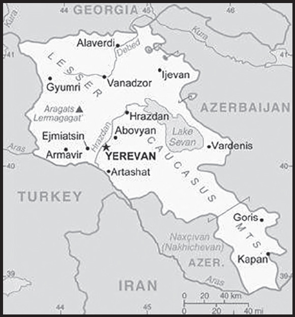
INTRODUCTION
Background: Armenia prides itself on being the first state to formally adopt Christianity (early 4th century). Armenia has existed as a political entity for centuries with varying geographical boundaries and differing levels of political independence, but for much of its history it was under the sway of various empires including the Roman, Byzantine, Arab, Persian, Ottoman, and Russian. During World War I, the Ottoman Empire instituted a policy of forced resettlement coupled with other harsh practices targeting its Armenian subjects, especially those living in the eastern provinces of Anatolia, that resulted in at least 1 million Armenian deaths; these actions have been widely recognized as constituting genocide. During the early 19th century, significant Armenian populations fell under Russian rule as a result of Russian military successes against the Persian (1813) and Ottoman (1828) empires. After the Bolshevik Revolution toppled the last Russian tsar in 1917, Armenia declared its independence in 1918, but was conquered by the Soviet Red Army in 1920. Armenia, along with Azerbaijan and Georgia, was initially incorporated into the USSR as part of the Transcaucasian Federated Soviet Socialist Republic; in 1936, the federated republic was separated into its three constituent entities, which were maintained until the dissolution of the Soviet Union in 1991.
Armenia has a longstanding conflict with neighboring Azerbaijan about the status of the Nagorno-Karabakh region. The region historically had a mixed Armenian and Azerbaijani population, although ethnic Armenians have constituted the majority since the late 19th century. In 1921, Moscow placed Nagorno-Karabakh within Soviet Azerbaijan as an autonomous oblast, a decision that Armenian political leaders and the public repeatedly sought to alter through petitions and complaints, starting in the 1930s. In the late Soviet period, a separatist movement developed that sought to end Azerbaijani control over the region. Fighting over Nagorno-Karabakh began in 1988 and escalated after Armenia and Azerbaijan attained independence from the Soviet Union in 1991. By the time a cease-fire took effect in May 1994, separatists, with Armenian support, controlled Nagorno-Karabakh and seven surrounding Azerbaijani territories. constituting a total of 14 percent of Azerbaijan’s overall territory. Armenia and Azerbaijan engaged in a second military conflict over Nagorno-Karabakh in September-November 2020, as a result of which Armenia lost control over much of the territory it had captured a quarter-century earlier. Under the terms of a cease-fire agreement signed in November 2020, Armenia returned the territories around Nagorno-Karabakh and some parts of Nagorno-Karabakh to Azerbaijan and accepted the deployment of Russian peacekeepers to the remainder of the region. Armenia’s only remaining territorial connection to Nagorno-Karabakh after 2020 was through the five-kilometer wide Lacin Corridor, which passed through Azerbaijani-held territory and was under the control of Russian peacekeepers.
Turkey closed its common border with Armenia in 1993 in support of Azerbaijan during the first period of conflict with Armenia and has maintained a closed border since then, leaving Armenia with closed borders both in the west (with Turkey) and east (with Azerbaijan). Armenia and Turkey engaged in intensive diplomacy to normalize their relations and open the border in 2009, but the signed agreement was not ratified in either country and became a dead letter in 2018, when Armenia officially withdrew its signature. In 2015, Armenia joined the Eurasian Economic Union alongside Russia, Belarus, Kazakhstan, and Kyrgyzstan. In November 2017, Armenia signed a Comprehensive and Enhanced Partnership Agreement (CEPA) with the EU.
In spring 2018, former President of Armenia (2008-18) Serzh SARGSIAN of the Republican Party of Armenia (RPA) tried to extend his time in power by becoming prime minister, prompting popular protests that became known as the “Velvet Revolution.” After SARGSIAN resigned, the leader of the protests, Civil Contract party chief Nikol PASHINYAN, was elected by the National Assembly as the new prime minister on 8 May 2018. PASHINYAN’s party has prevailed in subsequent legislative elections, most recently in June 2021.
GEOGRAPHY
Location: Southwestern Asia, between Turkey (to the west) and Azerbaijan; note - Armenia views itself as part of Europe; geopolitically, it can be classified as falling within Europe, the Middle East, or both
Geographic coordinates: 40 00 N, 45 00 E
Map references: Asia
Area: total: 29,743 sq km
land: 28,203 sq km
water: 1,540 sq km
comparison ranking: total 142
Area - comparative: slightly smaller than Maryland
Land boundaries: total: 1,570 km
border countries (4): Azerbaijan 996 km; Georgia 219 km; Iran 44 km; Turkey 311 km
Coastline: 0 km (landlocked)
Maritime claims: none (landlocked)
Climate: highland continental, hot summers, cold winters
Terrain: Armenian Highland with mountains; little forest land; fast flowing rivers; good soil in Aras River valley
Elevation: highest point: Aragats Lerrnagagat’ 4,090 m
lowest point: Debed River 400 m
mean elevation: 1,792 m
Natural resources: small deposits of gold, copper, molybdenum, zinc, bauxite
Land use: agricultural land: 59.7% (2018 est.)
arable land: 15.8% (2018 est.)
permanent crops: 1.9% (2018 est.)
permanent pasture: 42% (2018 est.)
forest: 9.1% (2018 est.)
other: 31.2% (2018 est.)
Irrigated land: 1,554 sq km (2020)
Major lakes (area sq km): fresh water lake(s): Lake Sevan - 1,360 sq km
Population distribution: most of the population is located in the northern half of the country; the capital of Yerevan is home to more than five times as many people as Gyumri, the second largest city in the country
Natural hazards: occasionally severe earthquakes; droughts
Geography - note: landlocked in the Lesser Caucasus Mountains; Sevana Lich (Lake Sevan) is the largest lake in this mountain range
PEOPLE AND SOCIETY
Population: 2,989,091 (2023 est.)
comparison ranking: 139
Nationality: noun: Armenian(s)
adjective: Armenian
Ethnic groups: Armenian 98.1%, Yezidi 1.2%, other 0.7% (2011 est.)
Languages: Armenian (official) 97.9%, Kurmanji (spoken by Yezidi minority) 1%, other 1.1%; note - Russian is widely spoken (2011 est.)
major-language sample(s):

(Armenian)
Religions: Armenian Apostolic Christian 92.6%, Evangelical Christian 1%, other 2.4%, none 1.1%, unspecified 2.9% (2011 est.)
Demographic profile: Armenia’s population peaked at nearly 3.7 million in the late 1980s but has declined sharply since independence in 1991, to just over 3 million in 2021, largely as a result of its decreasing fertility rate, increasing death rate, and negative net emigration rate. The total fertility rate (the average number of children born per woman) first fell below the 2.1 replacement level in the late 1990s and has hovered around 1.6-1.65 for over 15 years. In an effort to increase the country’s birth rate, the government has expanded its child benefits, including a substantial increase in the lump sum payment for having a first and second child and a boost in the monthly payment to mothers of children under two. Reversing net negative migration, however, remains the biggest obstacle to stabilizing or increasing population growth. Emigration causes Armenia not only lose individuals but also the children they might have.
The emigration of a significant number of working-age people combined with decreased fertility and increased life expectancy is causing the elderly share of Armenia’s population to grow. The growing elderly population will put increasing pressure on the government’s ability to fund the pension system, health care, and other services for seniors. Improving education, creating more jobs (particularly in the formal sector), promoting labor market participation, and increasing productivity would mitigate the financial impact of supporting a growing elderly population.
Armenia has a long history of migration, some forced and some voluntary. Its large diaspora is diverse and dispersed around the world. Widely varying estimates suggest the Armenian diaspora may number anywhere from 5-9 million, easily outnumbering the number of Armenians living in Armenia. Armenians forged communities abroad from ancient Egypt, Greece and Rome to Russia and to the Americas, where they excelled as craftsmen, merchants, and in other occupations.
Several waves of Armenian migration occurred in the 20th century. In the aftermath of the 1915 Armenian genocide, hundreds of thousands of survivors fled to communities in the Caucasus (including present day Armenia), Lebanon, Syria, Iran, Europe, and Russia and established new communities in Africa and the Americas. In the 1930s, the Soviets deported thousands of Armenians to Siberia and Central Asia. After World War II, the Soviets encouraged the Armenian diaspora in France, the Middle East, and Iran to return the Armenian homeland in order to encourage population growth after significant losses in the male workforce during the war.
Following Armenian independence in 1991, the economic downturn and high unemployment prompted hundreds of thousands of Armenians to seek better economic opportunities primarily in Russia but also in the US, former Soviet states, and Europe. In the early 1990s, hundreds of thousands of Armenians fled from Azerbaijan to Armenia because of the ongoing Nagorno-Karbakh conflict, but many of them then emigrated again, mainly to Russia and the US. When the economy became more stable in the late 1990s, permanent emigration slowed, but Armenians continued to seek temporary seasonal work in Russia. The remittances families receive from relatives working abroad is vital to Armenian households and the country’s economy.
Age structure: 0-14 years: 17.98% (male 282,055/female 255,313)
15-64 years: 67.53% (male 999,784/female 1,018,891)
65 years and over: 14.49% (2023 est.) (male 178,824/female 254,224)
Dependency ratios: total dependency ratio: 49.6
youth dependency ratio: 30.6
elderly dependency ratio: 19.1
potential support ratio: 5.2 (2021 est.)
Median age: total: 36.6 years (2020)
male: 35.1 years
female: 38.3 years
comparison ranking: total 78
Population growth rate: -0.4% (2023 est.)
comparison ranking: 219
Birth rate: 10.8 births/1,000 population (2023 est.)
comparison ranking: 172
Death rate: 9.54 deaths/1,000 population (2023 est.)
comparison ranking: 44
Net migration rate: -5.28 migrant(s)/1,000 population (2023 est.)
comparison ranking: 205
Population distribution: most of the population is located in the northern half of the country; the capital of Yerevan is home to more than five times as many people as Gyumri, the second largest city in the country
Urbanization: urban population: 63.7% of total population (2023)
rate of urbanization: 0.23% annual rate of change (2020-25 est.)
Major urban areas - population: 1.095 million YEREVAN (capital) (2023)
Sex ratio: at birth: 1.07 male(s)/female
0-14 years: 1.1 male(s)/female
15-64 years: 0.98 male(s)/female
65 years and over: 0.7 male(s)/female
total population: 0.96 male(s)/female (2023 est.)
Mother’s mean age at first birth: 25.2 years (2019 est.)
Maternal mortality ratio: 27 deaths/100,000 live births (2020 est.)
comparison ranking: 116
Infant mortality rate: total: 11.89 deaths/1,000 live births (2023 est.)
male: 13.43 deaths/1,000 live births
female: 10.24 deaths/1,000 live births
comparison ranking: total 117
Life expectancy at birth: total population: 76.4 years (2023 est.)
male: 73.13 years
female: 79.91 years
comparison ranking: total population 106
Total fertility rate: 1.65 children born/woman (2023 est.)
comparison ranking: 175
Gross reproduction rate: 0.8 (2023 est.)
Contraceptive prevalence rate: 57.1% (2015/16)
Drinking water source: improved: total: 100% of population
unimproved: total: 0% of population (2020 est.)
Current health expenditure: 12.2% of GDP (2020)
Physicians density: 4.4 physicians/1,000 population (2017)
Hospital bed density: 4.2 beds/1,000 population (2014)
Sanitation facility access: improved: urban: 100% of population
rural: 84.6% of population
total: 94.4% of population
unimproved: urban: 0% of population
rural: 15.4% of population
total: 5.6% of population (2020 est.)
Obesity - adult prevalence rate: 20.2% (2016)
comparison ranking: 101
Alcohol consumption per capita: total: 3.77 liters of pure alcohol (2019 est.)
beer: 0.52 liters of pure alcohol (2019 est.)
wine: 0.46 liters of pure alcohol (2019 est.)
spirits: 2.78 liters of pure alcohol (2019 est.)
other alcohols: 0.01 liters of pure alcohol (2019 est.)
comparison ranking: total 99
Tobacco use: total: 25.5% (2020 est.)
male: 49.4% (2020 est.)
female: 1.5% (2020 est.)
comparison ranking: total 45
Children under the age of 5 years underweight: 2.6% (2015/16)
comparison ranking: 95
Currently married women (ages 15-49): 64.8% (2023 est.)
Child marriage: women married by age 15: 0%
women married by age 18: 5.3%
men married by age 18: 0.4% (2016 est.)
Education expenditures: 2.8% of GDP (2021 est.)
comparison ranking: 167
Literacy: definition: age 15 and over can read and write
total population: 99.8%
male: 99.8%
female: 99.7% (2020)
School life expectancy (primary to tertiary education): total: 13 years
male: 13 years
female: 14 years (2021)
Youth unemployment rate (ages 15-24): total: 36.1% (2021 est.)
male: 34%
female: 38.7%
comparison ranking: total 23
ENVIRONMENT
Environment - current issues: soil pollution from toxic chemicals such as DDT; deforestation; pollution of Hrazdan and Aras Rivers; the draining of Sevana Lich (Lake Sevan), a result of its use as a source for hydropower, threatens drinking water supplies; restart of Metsamor nuclear power plant in spite of its location in a seismically active zone
Environment - international agreements: party to: Air Pollution, Biodiversity, Climate Change, Climate Change-Kyoto Protocol, Climate Change-Paris Agreement, Comprehensive Nuclear Test Ban, Desertification, Endangered Species, Environmental Modification, Hazardous Wastes, Law of the Sea, Nuclear Test Ban, Ozone Layer Protection, Wetlands
signed, but not ratified: Air Pollution-Heavy Metals, Air Pollution-Multi-effect Protocol, Air Pollution-Persistent Organic Pollutants
Climate: highland continental, hot summers, cold winters
Land use: agricultural land: 59.7% (2018 est.)
arable land: 15.8% (2018 est.)
permanent crops: 1.9% (2018 est.)
permanent pasture: 42% (2018 est.)
forest: 9.1% (2018 est.)
other: 31.2% (2018 est.)
Urbanization: urban population: 63.7% of total population (2023)
rate of urbanization: 0.23% annual rate of change (2020-25 est.)
Revenue from forest resources: 0.28% of GDP (2018 est.)
comparison ranking: 82
Revenue from coal: 0% of GDP (2018 est.)
comparison ranking: 101
Air pollutants: particulate matter emissions: 34.13 micrograms per cubic meter (2019 est.)
carbon dioxide emissions: 5.16 megatons (2016 est.)
methane emissions: 2.91 megatons (2020 est.)
Waste and recycling: municipal solid waste generated annually: 492,800 tons (2014 est.)
Major lakes (area sq km): fresh water lake(s): Lake Sevan - 1,360 sq km
Total water withdrawal: municipal: 650 million cubic meters (2020 est.)
industrial: 190 million cubic meters (2020 est.)
agricultural: 1.99 billion cubic meters (2020 est.)
Total renewable water resources: 7.77 billion cubic meters (2020 est.)
GOVERNMENT
Country name: conventional long form: Republic of Armenia
conventional short form: Armenia
local long form: Hayastani Hanrapetut’yun
local short form: Hayastan
former: Armenian Soviet Socialist Republic, Armenian Republic
etymology: the etymology of the country’s name remains obscure; according to tradition, the country is named after Hayk, the legendary patriarch of the Armenians and the great-great-grandson of Noah; Hayk’s descendant, Aram, purportedly is the source of the name Armenia
Government type: parliamentary democracy; note - constitutional changes adopted in December 2015 transformed the government to a parliamentary system
Capital: name: Yerevan
geographic coordinates: 40 10 N, 44 30 E
time difference: UTC+4 (9 hours ahead of Washington, DC, during Standard Time)
etymology: name likely derives from the ancient Urartian fortress of Erebuni established on the current site of Yerevan in 782 B.C. and whose impressive ruins still survive
Administrative divisions: 11 provinces (marzer, singular - marz); Aragatsotn, Ararat, Armavir, Geghark’unik’, Kotayk’, Lorri, Shirak, Syunik’, Tavush, Vayots’ Dzor, Yerevan
Independence: 21 September 1991 (from the Soviet Union); notable earlier dates: 321 B.C. (Kingdom of Armenia established under the Orontid Dynasty), A.D. 884 (Armenian Kingdom reestablished under the Bagratid Dynasty); 1198 (Cilician Kingdom established); 28 May 1918 (Democratic Republic of Armenia declared)
National holiday: Independence Day, 21 September (1991)
Constitution: history: previous 1915, 1978; latest adopted 5 July 1995
amendments: proposed by the president of the republic or by the National Assembly; passage requires approval by the president, by the National Assembly, and by a referendum with at least 25% registered voter participation and more than 50% of votes; constitutional articles on the form of government and democratic procedures are not amendable; amended 2005, 2015, last in 2020; the Constitutional Reform Council formed in 2019 was dissolved in December 2021, and replaced by a new Constitutional Reform Council, whose members were officially appointed in late January 2022; the new council is expected to address the form of government, i.e. presidential or semi-presidential or parliamentary, and whether to merge the Court of Cassation with the Constitutional Court
Legal system: civil law system
International law organization participation: has not submitted an ICJ jurisdiction declaration; non-party state to the ICCt
Citizenship: citizenship by birth: no
citizenship by descent only: at least one parent must be a citizen of Armenia
dual citizenship recognized: yes
residency requirement for naturalization: 3 years
Suffrage: 18 years of age; universal
Executive branch: chief of state: President Vahagn KHACHATURYAN (since 13 March 2022)
head of government: Prime Minister Nikol PASHINYAN (since 10 September 2021); Deputy Prime Ministers Mher GRIGORYAN (since 3 August 2021) and Tigran KHACHATRYAN (since 19 December 2022); note - Prime Minister Nikol PASHINYAN resigned on 25 April 2021 in advance of the 20 June 2021 parliamentary election; he was reappointed by the president on 2 August 2021 and sworn in on 10 September 2021
cabinet: Council of Ministers appointed by the prime minister
elections/appointments: president indirectly elected by the National Assembly in 3 rounds if needed for a single 7-year term; election last held on 2-3 March 2022; prime minister indirectly elected by majority vote in 2 rounds if needed by the National Assembly
election results: 2022: Vahagn KHACHATURYAN elected president in second round; note - Vahagn KHACHATURYAN ran unopposed and won the Assembly vote 71-0
2018: Armen SARKISSIAN elected president in first round; note - Armen SARKISSIAN ran unopposed and won the Assembly vote 90-10
note: Nikol PASHINYAN was first elected prime minister on 8 May 2018 and reelected on January 2019; in response to a political crisis that followed Armenia’s defeat in the Second Nagorno-Karabakh War in late 2020, PASHINYAN called an early legislative election for June 2021; his party won the election and PASHINYAN was elected to the prime ministership for a third time; his election was confirmed by the president on 2 August 2021, and he was sworn in on 10 September 2021
Legislative branch: description: unicameral National Assembly (Parliament) or Azgayin Zhoghov (minimum 101 seats, with additional seats allocated as necessary and generally changing with each parliamentary convocation; current - 107; members directly elected in single-seat constituencies by closed party-list proportional representation vote; members serve 5-year terms; four mandates are reserved for national minorities; no more than 70% of the top membership of a party list can belong to the same sex; political parties must meet a 5% threshold and alliances a 7% threshold to win seats; at least three parties must be seated in the Parliament)
elections: last held early on 20 June 2021 (next to be held in June 2026)
election results: percent of vote by party - Civil Contract 53.9%, Armenia Alliance 21%, I Have Honour Alliance 5.2%, other 19.9%; seats by party - Civil Contract 71, Armenia Alliance 29, I Have Honour Alliance 7; composition (as of August 2023) - men 69, women 38, percent of women 35.5%
Judicial branch: highest court(s): Court of Cassation or Appeals Court (consists of the Criminal Chamber with a chairman and 5 judges and the Civil and Administrative Chamber with a chairman and 10 judges – with both civil and administrative specializations); Constitutional Court (consists of 9 judges)
judge selection and term of office: Court of Cassation judges nominated by the Supreme Judicial Council, a 10- member body of selected judges and legal scholars; judges appointed by the president; judges can serve until age 65; Constitutional Court judges - 4 appointed by the president, and 5 elected by the National Assembly; judges can serve until age 70
subordinate courts: criminal and civil appellate courts; administrative appellate court; first instance courts; specialized administrative and bankruptcy courts
Political parties and leaders: 5165 National Conservative Movement Party [Karin TONOYAN]
Alliance of Democrats [Arman BABAJANYAN]
Armenia Alliance or HD [Robert KOCHARYAN]
(formerly known as the Armenian Revolutionary Federation)
Armenian National Congress or ANC [Levon TER-PETROSSIAN] (bloc of independent and opposition parties)
Bright Armenia [Edmon MARUKYAN]
Civil Contract or KP [Nikol PASHINYAN]
Country To Live In [Mane TANDILYAN]
Homeland of Armenians [Artak GALSTYAN]
Homeland Party [Artur VANETSYAN]
I Have Honor Alliance (formerly known as the Republican Party of Armenia, [Serzh SARGSIAN]
Liberal Party [Samvel BABAYAN]
National Democratic Party [Vahe GASPARYAN]
Prosperous Armenia or BHK [Gagik TSARUKYAN]
Republic Party (Hanrapetutyun Party) [Aram SARGSYAN]
International organization participation: ADB, BSEC, CD, CE, CIS, CSTO, EAEC (observer), EAEU, EAPC, EBRD, FAO, GCTU, IAEA, IBRD, ICAO, ICC (NGOs), ICRM, IDA, IFAD, IFC, IFRCS, ILO, IMF, Interpol, IOC, IOM, IPU, ISO, ITSO, ITU, MIGA, NAM (observer), OAS (observer), OIF, OPCW, OSCE, PFP, UN, UNCTAD, UNESCO, UNIDO, UNIFIL, UNWTO, UPU, WCO, WFTU (NGOs), WHO, WIPO, WMO, WTO
Diplomatic representation in the US: chief of mission: Ambassador Lilit MAKUNTS (since 15 September 2021)
chancery: 2225 R Street NW, Washington, DC 20008
telephone: [1] (202) 319-1976
FAX: [1] (202) 319-2982
email address and website: armembassyusa@mfa.am
consulate(s) general: Glendale (CA)
Diplomatic representation from the US: chief of mission: Ambassador Kristina A. KVIEN (since 21 February 2023)
embassy: 1 American Ave., Yerevan 0082
mailing address: 7020 Yerevan Place, Washington, DC 20521-7020
telephone: [374] (10) 464-700
FAX: [374] (10) 464-742
email address and website: acsyerevan@state.gov
Flag description: three equal horizontal bands of red (top), blue, and orange; the color red recalls the blood shed for liberty, blue the Armenian skies as well as hope, and orange the land and the courage of the workers who farm it
National symbol(s): Mount Ararat, eagle, lion; national colors: red, blue, orange
National anthem: name: “Mer Hayrenik” (Our Fatherland)
lyrics/music: Mikael NALBANDIAN/Barsegh KANACHYAN
note: adopted 1991; based on the anthem of the Democratic Republic of Armenia (1918-1922) but with different lyrics
National heritage: total World Heritage Sites: 3 (3 cultural)
selected World Heritage Site locales: Monasteries of Haghpat and Sanahin; Monastery of Geghard and the Upper Azat Valley; Cathedral and Churches of Echmiatsin
ECONOMY
Economic overview: EEU-and CIS-member state but seeking more EU and US trade; business-friendly growth environments; stable monetary regime but vulnerable demand economy; key copper and gold exporter; persistent unemployment; large diaspora and remittances
Real GDP (purchasing power parity): $39.613 billion (2021 est.)
$37.476 billion (2020 est.)
$40.384 billion (2019 est.)
note: data are in 2017 dollars
comparison ranking: 122
Real GDP growth rate: 5.7% (2021 est.)
-7.2% (2020 est.)
7.6% (2019 est.)
comparison ranking: 77
Real GDP per capita: $14,200 (2021 est.)
$13,400 (2020 est.)
$14,300 (2019 est.)
note: data are in 2017 dollars
comparison ranking: 115
GDP (official exchange rate): $13.694 billion (2019 est.)
Inflation rate (consumer prices): 7.18% (2021 est.)
1.21% (2020 est.)
1.44% (2019 est.)
comparison ranking: 45
Credit ratings: Fitch rating: B+ (2020)
Moody’s rating: Ba3 (2019)
note: The year refers to the year in which the current credit rating was first obtained.
GDP - composition, by sector of origin: agriculture: 16.7% (2017 est.)
industry: 28.2% (2017 est.)
services: 54.8% (2017 est.)
comparison rankings: services 157; industry 92; agriculture 59
GDP - composition, by end use: household consumption: 76.7% (2017 est.)
government consumption: 14.2% (2017 est.)
investment in fixed capital: 17.3% (2017 est.)
investment in inventories: 4.1% (2017 est.)
exports of goods and services: 38.1% (2017 est.)
imports of goods and services: -50.4% (2017 est.)
Agricultural products: milk, potatoes, grapes, vegetables, tomatoes, watermelons, wheat, apples, cabbages, barley
Industries: brandy, mining, diamond processing, metal-cutting machine tools, forging and pressing machines, electric motors, knitted wear, hosiery, shoes, silk fabric, chemicals, trucks, instruments, microelectronics, jewelry, software, food processing
Industrial production growth rate: 3.4% (2021 est.)
comparison ranking: 114
Labor force: 1.153 million (2021 est.)
comparison ranking: 141
Labor force - by occupation: agriculture: 36.3%
industry: 17%
services: 46.7% (2013 est.)
Unemployment rate: 20.9% (2021 est.)
21.21% (2020 est.)
18.3% (2019 est.)
comparison ranking: 19
Youth unemployment rate (ages 15-24): total: 36.1% (2021 est.)
male: 34%
female: 38.7%
comparison ranking: total 23
Population below poverty line: 26.4% (2019 est.)
Gini Index coefficient - distribution of family income: 25.2 (2020 est.)
comparison ranking: 173
Household income or consumption by percentage share: lowest 10%: 3.5%
highest 10%: 25.7% (2014)
Budget: revenues: $3.258 billion (2019 est.)
expenditures: $3.392 billion (2019 est.)
Budget surplus (+) or deficit (-): -4.8% (of GDP) (2017 est.)
comparison ranking: 167
Public debt: 63.4% of GDP (2020 est.)
50.03% of GDP (2019 est.)
comparison ranking: 74
Taxes and other revenues: 21.86% (of GDP) (2020 est.)
comparison ranking: 73
Fiscal year: calendar year
Current account balance: -$515.126 million (2021 est.)
-$477.811 million (2020 est.)
-$996.978 million (2019 est.)
comparison ranking: 118
Exports: $5.012 billion (2021 est.)
$3.818 billion (2020 est.)
$5.794 billion (2019 est.)
note: Data are in current year dollars and do not include illicit exports or re-exports.
comparison ranking: 130
Exports - partners: Russia 22%, Switzerland 20%, China 7%, Bulgaria 6%, Iraq 5%, Serbia 5%, Netherlands 5%, Germany 5% (2019)
Exports - commodities: copper ore, gold, liquors, iron alloys, tobacco (2021)
Imports: $6.12 billion (2021 est.) note: data are in current year dollars
$5.082 billion (2020 est.) note: data are in current year dollars
$7.603 billion (2019 est.) note: data are in current year dollars
comparison ranking: 135
Imports - partners: Russia 29%, China 10%, Georgia 8%, Iran 6%, Turkey 5% (2019)
Imports - commodities: natural gas, cars, refined petroleum, broadcasting equipment, diamonds (2019)
Reserves of foreign exchange and gold: $3.23 billion (31 December 2021 est.)
$2.616 billion (31 December 2020 est.)
$2.85 billion (31 December 2019 est.)
comparison ranking: 116
Debt - external: $11.637 billion (2019 est.)
$10.785 billion (2018 est.)
comparison ranking: 110
Exchange rates: drams (AMD) per US dollar -
Exchange rates: 503.77 (2021 est.)
489.009 (2020 est.)
480.445 (2019 est.)
482.988 (2018 est.)
482.716 (2017 est.)
ENERGY
Electricity access: electrification - total population: 100% (2021)
Electricity: installed generating capacity: 3.633 million kW (2020 est.)
consumption: 5,758,470,000 kWh (2019 est.)
exports: 1.251 billion kWh (2020 est.)
imports: 320 million kWh (2020 est.)
transmission/distribution losses: 548 million kWh (2019 est.)
comparison rankings: imports 95; exports 56; installed generating capacity 101; transmission/distribution losses 128; consumption 120
Electricity generation sources: fossil fuels: 40.6% of total installed capacity (2020 est.)
nuclear: 34.8% of total installed capacity (2020 est.)
solar: 0.3% of total installed capacity (2020 est.)
wind: 0% of total installed capacity (2020 est.)
hydroelectricity: 24.3% of total installed capacity (2020 est.)
tide and wave: 0% of total installed capacity (2020 est.)
geothermal: 0% of total installed capacity (2020 est.)
biomass and waste: 0% of total installed capacity (2020 est.)
Nuclear energy: Number of operational nuclear reactors: 1 (2023)
Number of nuclear reactors under construction: 0
Net capacity of operational nuclear reactors: 0.42GW (2023)
Percent of total electricity production: 25.3% (2021)
Percent of total energy produced: 52.3% (2021)
Number of nuclear reactors permanently shut down: 0
Coal: production: 0 metric tons (2020 est.)
consumption: 12,000 metric tons (2020 est.)
exports: 0 metric tons (2020 est.)
imports: 12,000 metric tons (2020 est.)
proven reserves: 163 million metric tons (2019 est.)
Petroleum: total petroleum production: 0 bbl/day (2021 est.)
refined petroleum consumption: 10,900 bbl/day (2019 est.)
crude oil and lease condensate exports: 0 bbl/day (2018 est.)
crude oil and lease condensate imports: 0 bbl/day (2018 est.)
crude oil estimated reserves: 0 barrels (2021 est.)
Refined petroleum products - production: 0 bbl/day (2015 est.)
comparison ranking: 193
Refined petroleum products - exports: 0 bbl/day (2015 est.)
comparison ranking: 167
Refined petroleum products - imports: 7,145 bbl/day (2015 est.)
comparison ranking: 158
Natural gas: production: 0 cubic meters (2021 est.)
consumption: 2,537,497,000 cubic meters (2019 est.)
exports: 0 cubic meters (2021 est.)
imports: 2,514,220,000 cubic meters (2019 est.)
proven reserves: 0 cubic meters (2021 est.)
Carbon dioxide emissions: 6.354 million metric tonnes of CO2 (2019 est.)
from coal and metallurgical coke: 12,000 metric tonnes of CO2 (2019 est.)
from petroleum and other liquids: 1.364 million metric tonnes of CO2 (2019 est.)
from consumed natural gas: 4.978 million metric tonnes of CO2 (2019 est.)
comparison ranking: total emissions 130
Energy consumption per capita: 53.019 million Btu/person (2019 est.)
comparison ranking: 98
COMMUNICATIONS
Telephones - fixed lines: total subscriptions: 418,122 (2021 est.)
subscriptions per 100 inhabitants: 15 (2021 est.)
comparison ranking: total subscriptions 101
Telephones - mobile cellular: total subscriptions: 3,599,278 (2021 est.)
subscriptions per 100 inhabitants: 129 (2021 est.)
comparison ranking: total subscriptions 138
Telecommunication systems: general assessment: Armenia’s telecom sector was able to post in the mobile and broadband segments; its fixed-line penetration continues to slide downwards, with the rollout of fiber networks which have encouraged the increase in bundled services; the fixed broadband market remains undeveloped due to the lack of underlying infrastructure outside the main cities (2021)
domestic: roughly 15 per 100 fixed-line and 129 per 100 mobile-cellular; reliable fixed-line and mobile-cellular services are available across Yerevan and in major cities and towns; mobile-cellular coverage available in most rural areas (2021)
international: country code - 374; Yerevan is connected to the Caucasus Cable System fiber-optic cable through Georgia and Iran to Europe; additional international service is available by microwave radio relay and landline connections to the other countries of the Commonwealth of Independent States, through the Moscow international switch, and by satellite to the rest of the world; satellite earth stations - 3 (2019)
Broadcast media: Armenia’s government-run Public Television network operates alongside 100 privately owned TV stations that provide local to near nationwide coverage; three Russian TV companies are broadcast in Armenia under interstate agreements; subscription cable TV services are available in most regions; several major international broadcasters are available, including CNN; Armenian TV completed conversion from analog to digital broadcasting in late 2016; Public Radio of Armenia is a national, state-run broadcast network that operates alongside 18 privately owned radio stations
(2019)
Internet country code: .am
Internet users: total: 2.212 million (2021 est.)
percent of population: 79% (2021 est.)
comparison ranking: total 133
Broadband - fixed subscriptions: total: 430,407 (2020 est.)
subscriptions per 100 inhabitants: 15 (2020 est.)
comparison ranking: total 95
TRANSPORTATION
National air transport system: number of registered air carriers: 3 (2020)
inventory of registered aircraft operated by air carriers: 5
Civil aircraft registration country code prefix: EK
Airports: 7 (2021)
comparison ranking: total 166
Airports - with paved runways: 10
civil airports: 2
military airports: 0
joint use (civil-military) airports: 1
other airports: 7
note: paved runways have a concrete or asphalt surface but not all have facilities for refueling, maintenance, or air traffic control; the length of a runway required for aircraft to safely operate depends on a number of factors including the type of aircraft, the takeoff weight (including passengers, cargo, and fuel), engine types, flap settings, landing speed, elevation of the airport, and average maximum daily air temperature; paved runways can reach a length of 5,000 m (16,000 ft.), but the “typical” length of a commercial airline runway is between 2,500-4,000 m (8,000-13,000 ft.)
Airports - with unpaved runways: 1
note: unpaved runways have a surface composition such as grass or packed earth and are most suited to the operation of light aircraft; unpaved runways are usually short, often less than 1,000 m (3,280 ft.) in length; airports with unpaved runways often lack facilities for refueling, maintenance, or air traffic control
Pipelines: 3,838 km gas (high and medium pressure) (2017)
Railways: total: 686 km (2017)
comparison ranking: total 101
Roadways: total: 7,700 km (2019)
urban: 3,780 km
non-urban: 3,920 km
comparison ranking: total 140
MILITARY AND SECURITY
Military and security forces: Armenian Republic Armed Forces: Armenian Army (includes land, air, air defense forces) (2023)
note: the Police of the Republic of Armenia is responsible for internal security, while the National Security Service is responsible for national security, intelligence activities, and border control
Military expenditures: 4.3% of GDP (2022 est.)
4.4% of GDP (2021 est.)
5% of GDP (2020 est.)
5.3% of GDP (2019 est.)
4.6% of GDP (2018 est.)
comparison ranking: 14
Military and security service personnel strengths: approximately 45,000 active troops (42,000 ground; 3,000 air/defense) (2022)
Military equipment inventories and acquisitions: the military’s inventory includes mostly Russian and Soviet-era equipment (2023)
Military service age and obligation: 18-27 for voluntary (men and women), contract (men and women) or compulsory (men) military service; contract military service is 3-12 months or 3 or 5 years; conscripts serve 24 months; men under the age of 36, who have not previously served as contract servicemen and are registered in the reserve, as well as women, regardless of whether they are registered in the reserve can be enrolled in contractual military service; all citizens aged 27 to 50 are registered in the military reserve and may be called to serve if mobilization is declared (2023)
note: in 2023, Armenia approved six-month voluntary service for women, after which they have the option to switch to a five-year contract; previously, women served on a contract basis
note 2: as of 2021, conscripts comprised about half of the military’s active personnel; as of 2020, women made up about 10% of the active duty military; the Armenian Army established its first all-women combat unit in 2020
Military - note: the Armenian Armed Forces were officially established in 1992, although their origins go back to 1918; the modern military’s missions include deterrence, territorial defense, crisis management, humanitarian assistance, and disaster response, as well as socio-economic development projects; territorial defense is its primary focus, particularly in regards to tensions with neighboring Azerbaijan over the Nagorno-Karabakh region; Armenia and Azerbaijan engaged in open conflicts over the Nagorno-Karabakh enclave in 1991-94 and 2020, plus a brief flare-up in 2016; tensions continued following the 2020 conflict; Azerbaijan seized the entire enclave in 2023
the bulk of the Armenian military’s ground combat forces are organized into five small corps that are typically comprised of one or more Soviet-style “motorized rifle” (mechanized infantry) regiments, plus supporting units of artillery, reconnaissance, and tank forces; there are also separate artillery, air defense, battlefield rockets, and special operations forces; four of the five corps are typically deployed along the border with Azerbaijan with the fifth deployed along the border with Turkey; the ground forces also have a peacekeeping brigade; the air combat forces consist of small numbers of Soviet-era ground attack aircraft and attack helicopters; Armenia is landlocked so it has no naval forces
Armenia has close military ties with Russia and hosts Russian military forces at two bases, as well as Russian border guards along multiple border areas; it has been a member of the Russian-led Collective Security Treaty Organization (CSTO) since 1994 and committed troops to CSTO’s rapid reaction force; Armenia has relations with NATO going back to 1992 when Armenia joined the North Atlantic Cooperation Council; in 1994, it joined NATO’s Partnership for Peace program and has contributed to the NATO force in Kosovo, as well as the former NATO deployment in Afghanistan (2023)
SPACE
Space agency/agencies: no government agency; Armenia Space Agency (ArmCosmos; established 2013) is a private agency that operates on behalf of the Armenian Government to develop the country’s commercial space industry and facilitate international engagement on space, particularly satellites for Armenia (2023)
Space program overview: seeks foreign providers for satellite communications, remote sensing (RS), and navigational services; otherwise relies on Russia for satellite needs; seeks to use RS satellite data for border control, emergency prevention and management, environmental protection/climate change monitoring, geology, road construction, urban planning, and other purposes; cooperates with a variety of foreign space agencies and industries, including those of China, the European Space Agency (and individual ESA member states such as Germany and Spain), India, Russia, and the US; has a state-owned company involved in satellite development and production (2023)
note: further details about the key activities, programs, and milestones of the country’s space program, as well as government spending estimates on the space sector, appear in Appendix S
TRANSNATIONAL ISSUES
Disputes - international: local border forces struggle to control the illegal transit of goods and people across the porous, undemarcated Armenian, Azerbaijani, and Georgian borders
Armenia-Azerbaijan: tensions existed for years over the break-away Nagorno-Karabakh region and the Armenian military occupation of surrounding lands in Azerbaijan; Azerbaijan seized part of the enclave during six weeks of fighting in 2020 and the remainder in a short conflict in September 2023; in October 2023, Baku and Yerevan began preliminary discussions on a peace treaty, the demarcation of borders, and full normalization of relations; nevertheless, concerns persist in Armenia that Azerbaijan could invade in order to force the establishment of a transit corridor to the exclave of Naxicvan (Nakhichevan)
Armenia-Georgia: Georgians restrict Armenian access into Samtse-Javakheti ethnic Armenian areas; Armenia has made no claims to the region
Armenia-Iran: none identified
Armenia-Turkey: as of 2023, Turkey and Armenia were discussing normalizing relations
Refugees and internally displaced persons: refugees (country of origin): 27,929 (Azerbaijan) (mid-year 2022)
IDPs: 8,400 (2022)
stateless persons: 816 (2022)
Illicit drugs: a transit country for illicit drugs with its location between source countries Afghanistan and Iran and the markets of Europe and Russia.