INTRODUCTION
Background: Discovered and claimed for Spain in 1499, Aruba was acquired by the Dutch in 1636. The island’s economy has been dominated by three main industries. A 19th century gold rush was followed by prosperity brought on by the opening in 1924 of an oil refinery. The last decades of the 20th century saw a boom in the tourism industry. Aruba seceded from the Netherlands Antilles in 1986 and became a separate, semi-autonomous member of the Kingdom of the Netherlands. Movement toward full independence was halted at Aruba’s request in 1990.
GEOGRAPHY
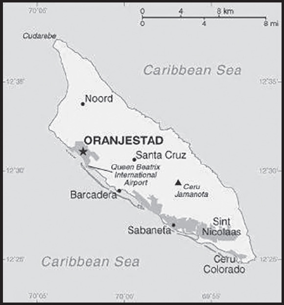
Location: Caribbean, island in the Caribbean Sea, north of Venezuela
Geographic coordinates: 12 30 N, 69 58 W
Map references: Central America and the Caribbean
Area: total: 180 sq km
land: 180 sq km
water: 0 sq km
comparison ranking: total 217
Area - comparative: slightly larger than Washington, DC
Land boundaries: total: 0 km
Coastline: 68.5 km
Maritime claims: territorial sea: 12 nm
exclusive economic zone: 200 nm
Climate: tropical marine; little seasonal temperature variation
Terrain: flat with a few hills; scant vegetation
Elevation: highest point: Ceru Jamanota 188 m
lowest point: Caribbean Sea 0 m
Natural resources: NEGL; white sandy beaches foster tourism
Land use: agricultural land: 11.1% (2018 est.)
arable land: 11.1% (2018 est.)
permanent crops: 0% (2018 est.)
permanent pasture: 0% (2018 est.)
forest: 2.3% (2018 est.)
other: 86.6% (2018 est.)
Irrigated land: NA
Population distribution: most residents live in or around Oranjestad and San Nicolaas; most settlments tend to be located on the less mountainous western side of the island
Natural hazards: hurricanes; lies outside the Caribbean hurricane belt and is rarely threatened
Geography - note: a flat, riverless island renowned for its white sand beaches; its tropical climate is moderated by constant trade winds from the Atlantic Ocean; the temperature is almost constant at about 27 degrees Celsius (81 degrees Fahrenheit)
PEOPLE AND SOCIETY
Population: 123, 702 (2023 est.)
comparison ranking: 188
Nationality: noun: Aruban(s)
adjective: Aruban; Dutch
Ethnic groups: Dutch 78.7%, Colombian 6.6%, Venezuelan 5.5%, Dominican 2.8%, Haitian 1.3%, other 5.1% (2020 est.)
note: data represent population by nationality
Languages: Papiamento (official) (a creole language that is a mixture of Portuguese, Spanish, Dutch, English, and, to a lesser extent, French, as well as elements of African languages and the language of the Arawak) 69.4%, Spanish 13.7%, English (widely spoken) 7.1%, Dutch (official) 6.1%, Chinese 1.5%, other 1.7%, unspecified 0.4% (2010 est.)
Religions: Roman Catholic 75.3%, Protestant 4.9% (includes Methodist 0.9%, Adventist 0.9%, Anglican 0.4%, other Protestant 2.7%), Jehovah’s Witness 1.7%, other 12%, none 5.5%, unspecified 0.5% (2010 est.)
Age structure: 0-14 years: 17.32% (male 10,745/female 10,677)
15-64 years: 66.11% (male 39,490/female 42,284)
65 years and over: 16.58% (2023 est.) (male 8,237/female 12,269)
Dependency ratios: total dependency ratio: 47.8
youth dependency ratio: 24.8
elderly dependency ratio: 23
potential support ratio: 4.4 (2021 est.)
Median age: total: 39.9 years (2020)
male: 38.2 years
female: 41.5 years
comparison ranking: total 53
Population growth rate: 1.11% (2023 est.)
comparison ranking: 84
Birth rate: 11.69 births/1,000 population (2023 est.)
comparison ranking: 158
Death rate: 8.69 deaths/1,000 population (2023 est.)
comparison ranking: 69
Net migration rate: 8.08 migrant(s)/1,000 population (2023 est.)
comparison ranking: 11
Population distribution: most residents live in or around Oranjestad and San Nicolaas; most settlments tend to be located on the less mountainous western side of the island
Urbanization: urban population: 44.3% of total population (2023)
rate of urbanization: 0.77% annual rate of change (2020-25 est.)
Major urban areas - population: 30,000 ORANJESTAD (capital) (2018)
Sex ratio: at birth: 1.02 male(s)/female
0-14 years: 1.01 male(s)/female
15-64 years: 0.93 male(s)/female
65 years and over: 0.67 male(s)/female
total population: 0.9 male(s)/female (2023 est.)
Infant mortality rate: total: 11.79 deaths/1,000 live births (2023 est.)
male: 16.04 deaths/1,000 live births
female: 7.45 deaths/1,000 live births
comparison ranking: total 119
Life expectancy at birth: total population: 78.25 years (2023 est.)
male: 75.19 years
female: 81.37 years
comparison ranking: total population 80
Total fertility rate: 1.82 children born/woman (2023 est.)
comparison ranking: 140
Gross reproduction rate: 0.9 (2023 est.)
Drinking water source: improved: urban: 98.1% of population
rural: 98.1% of population
total: 98.1% of population
unimproved: urban: 1.9% of population
rural: 1.9% of population
total: 1.9% of population (2015 est.)
Sanitation facility access: improved: total: 97.7% of population
unimproved: total: 2.3% of population (2015 est.)
Currently married women (ages 15-49): 42.1% (2023 est.)
Education expenditures: 5.5% of GDP (2016 est.)
comparison ranking: 54
Literacy: definition: age 15 and over can read and write
total population: 97.8%
male: 97.8%
female: 97.8% (2018)
School life expectancy (primary to tertiary education): total: 14 years
male: 13 years
female: 14 years (2012)
ENVIRONMENT
Environment - current issues: difficulty in properly disposing of waste produced by large numbers of tourists; waste burning that occurs in the landfill causes air pollution and poses an environmental and health risk; ocean environmental damage due to plastic pollution
Climate: tropical marine; little seasonal temperature variation
Land use: agricultural land: 11.1% (2018 est.)
arable land: 11.1% (2018 est.)
permanent crops: 0% (2018 est.)
permanent pasture: 0% (2018 est.)
forest: 2.3% (2018 est.)
other: 86.6% (2018 est.)
Urbanization: urban population: 44.3% of total population (2023)
rate of urbanization: 0.77% annual rate of change (2020-25 est.)
Revenue from forest resources: 0% of GDP (2017 est.)
comparison ranking: 202
Air pollutants: carbon dioxide emissions: 0.88 megatons (2016 est.)
Waste and recycling: municipal solid waste generated annually: 88,132 tons (2013 est.)
municipal solid waste recycled annually: 9,695 tons (2013 est.)
percent of municipal solid waste recycled: 11% (2013 est.)
GOVERNMENT
Country name: conventional long form: Country of Aruba
conventional short form: Aruba
local long form: Land Aruba (Dutch); Pais Aruba (Papiamento)
local short form: Aruba
etymology: the origin of the island’s name is unclear; according to tradition, the name comes from the Spanish phrase “oro huba” (there was gold), but in fact no gold was ever found on the island; another possibility is the native word “oruba,” which means “well-situated”
Government type: parliamentary democracy; part of the Kingdom of the Netherlands
Dependency status: constituent country of the Kingdom of the Netherlands; full autonomy in internal affairs obtained in 1986 upon separation from the Netherlands Antilles; Dutch Government responsible for defense and foreign affairs
Capital: name: Oranjestad
geographic coordinates: 12 31 N, 70 02 W
time difference: UTC-4 (1 hour ahead of Washington, DC, during Standard Time)
etymology: translates as “orange town” in Dutch; the city is named after William I (1533-1584), Prince of Orange, the first ruler of the Netherlands
Administrative divisions: none (part of the Kingdom of the Netherlands)
note: Aruba is one of four constituent countries of the Kingdom of the Netherlands; the other three are the Netherlands, Curacao, and Sint Maarten
Independence: none (part of the Kingdom of the Netherlands)
National holiday: National Anthem and Flag Day, 18 March (1976)
Constitution: history: previous 1947, 1955; latest drafted and approved August 1985, enacted 1 January 1986 (regulates governance of Aruba but is subordinate to the Charter for the Kingdom of the Netherlands); in 1986, Aruba became a semiautonomous entity within the Kingdom of the Netherlands
Legal system: civil law system based on the Dutch civil code
Citizenship: see the Netherlands
Suffrage: 18 years of age; universal
Executive branch: chief of state: King WILLEM-ALEXANDER of the Netherlands (since 30 April 2013); represented by Governor General Alfonso BOEKHOUDT (since 1 January 2017)
head of government: Prime Minister Evelyn WEVER-CROES (since 17 November 2017)
cabinet: Council of Ministers elected by the Legislature (Staten)
elections/appointments: the monarchy is hereditary; governor general appointed by the monarch for a 6-year term; prime minister and deputy prime minister indirectly elected by the Staten for 4-year term; election last held on 25 June 2021 (next to be held by June 2026)
election results: as leader of the majority party of the ruling coalition, Evelyn WEVER-CROES (MEP) elected prime minister; percent of Staten vote - NA
Legislative branch: description: unicameral Legislature or Staten (21 seats; members directly elected in a single nationwide constituency by proportional representation vote; members serve 4-year terms)
elections: last held on 25 June 2021 (next to be held in June 2025)
election results: percent of vote by party MEP 35.3%, AVP 31.3%, ROOTS 9.4%, MAS 8%, Accion21 5.8%; seats by party - MEP 9, AVP 7, ROOTS 2, MAS 2, Accion21 1; composition - men 13, women 8, percent of women as of September 2023 - 38.1%
Judicial branch: highest court(s): Joint Court of Justice of Aruba, Curacao, Sint Maarten, and of Bonaire, Sint Eustatius and Saba or “Joint Court of Justice” (sits as a 3-judge panel); final appeals heard by the Supreme Court in The Hague, Netherlands
judge selection and term of office: Joint Court judges appointed for life by the monarch
subordinate courts: Court in First Instance
Political parties and leaders: Accion21 [Miguel MANSUR]
Aruban People’s Party or AVP [Michiel “Mike” EMAN]
Democratic Network or RED [Ricardo CROES]
Movimiento Aruba Soberano (Aruban Sovereignty Movement) or MAS [Marisol LOPEZ-TROMP]
People’s Electoral Movement Party or MEP [Evelyn WEVER-CROES]
Pueblo Orguyoso y Respeta or POR [Alan Howell]
RAIZ (ROOTS) [Ursell ARENDS]
International organization participation: Caricom (observer), FATF, ILO, IMF, Interpol, IOC, ITUC (NGOs), UNESCO (associate), UNWTO (associate), UPU
Diplomatic representation in the US: chief of mission: none (represented by the Kingdom of the Netherlands)
Diplomatic representation from the US: embassy: the US does not have an embassy in Aruba; the Consul General to Curacao is accredited to Aruba
Flag description: blue, with two narrow, horizontal, yellow stripes across the lower portion and a red, four-pointed star outlined in white in the upper hoist-side corner; the star represents Aruba and its red soil and white beaches, its four points the four major languages (Papiamento, Dutch, Spanish, English) as well as the four points of a compass, to indicate that its inhabitants come from all over the world; the blue symbolizes Caribbean waters and skies; the stripes represent the island’s two main “industries”: the flow of tourists to the sun-drenched beaches and the flow of minerals from the earth
National symbol(s): Hooiberg (Haystack) Hill; national colors: blue, yellow, red, white
National anthem: name: “Aruba Deshi Tera” (Aruba Precious Country)
lyrics/music: Juan Chabaya ‘Padu’ LAMPE/Rufo Inocencio WEVER
note: local anthem adopted 1986; as part of the Kingdom of the Netherlands, “Het Wilhelmus” is official (see Netherlands)
ECONOMY
Economic overview: small, tourism-dependent, territorial-island economy; very high public debt; COVID-19 crippled economic activity; partial recovery underway via tourism, benefitting from its high amount of timeshare residences; considering reopening oil refinery
Real GDP (purchasing power parity): $4.141 billion (2021 est.)
$3.534 billion (2020 est.)
$4.341 billion (2019 est.)
comparison ranking: 183
Real GDP growth rate: 17.17% (2021 est.)
-18.59% (2020 est.)
0.64% (2019 est.)
comparison ranking: 7
Real GDP per capita: $38,900 (2021 est.)
$33,200 (2020 est.)
$40,800 (2019 est.)
comparison ranking: 52
GDP (official exchange rate): $2.7 billion (2017 est.)
Inflation rate (consumer prices): 4.26% (2019 est.)
3.63% (2018 est.)
-1.03% (2017 est.)
comparison ranking: 82
Credit ratings: Fitch rating: BB (2020)
Standard & Poors rating: BBB+ (2013)
note: The year refers to the year in which the current credit rating was first obtained.
GDP - composition, by sector of origin: agriculture: 0.4% (2002 est.)
industry: 33.3% (2002 est.)
services: 66.3% (2002 est.)
comparison rankings: services 89; industry 54; agriculture 212
GDP - composition, by end use: household consumption: 60.3% (2014 est.)
government consumption: 25.3% (2015 est.)
investment in fixed capital: 22.3% (2014 est.)
investment in inventories: 0% (2015 est.)
exports of goods and services: 70.5% (2015 est.)
imports of goods and services: -76.6% (2015 est.)
Agricultural products: aloes; livestock; fish
Industries: tourism, petroleum transshipment facilities, banking
Labor force: 51,610 (2007 est.)
note: of the 51,610 workers aged 15 and over in the labor force, 32,252 were born in Aruba and 19,353 came from abroad; foreign workers are 38% of the employed population
comparison ranking: 193
Labor force - by occupation: note: most employment is in wholesale and retail trade, followed by hotels and restaurants
Unemployment rate: 7.7% (2016 est.)
comparison ranking: 100
Budget: revenues: $793 million (2019 est.)
expenditures: $782 million (2019 est.)
Budget surplus (+) or deficit (-): -2.7% (of GDP) (2017 est.)
comparison ranking: 121
Public debt: 86% of GDP (2017 est.)
84.7% of GDP (2016 est.)
comparison ranking: 38
Taxes and other revenues: 25.2% (of GDP) (2017 est.)
comparison ranking: 47
Fiscal year: calendar year
Current account balance: $79.257 million (2021 est.)
-$316.455 million (2020 est.)
$84.797 million (2019 est.)
comparison ranking: 68
Exports: $2.201 billion (2021 est.)
$1.444 billion (2020 est.)
$2.562 billion (2019 est.)
note: Data are in current year dollars and do not include illicit exports or re-exports.
comparison ranking: 156
Exports - partners: Malaysia 57%, United States 11%, Netherlands 6%, Jordan 6%, Venezuela 5% (2019)
Exports - commodities: crude petroleum, cigarettes, whiskies, refined petroleum, scrap iron (2021)
Imports: $1.947 billion (2021 est.) note: data are in current year dollars
$1.644 billion (2020 est.) note: data are in current year dollars
$2.24 billion (2019 est.) note: data are in current year dollars
comparison ranking: 173
Imports - partners: United States 48%, Netherlands 16% (2019)
Imports - commodities: refined petroleum, jewelry, cars, vehicle parts, tobacco products (2019)
Reserves of foreign exchange and gold: $1.513 billion (31 December 2021 est.)
$1.213 billion (31 December 2020 est.)
$982.3 million (31 December 2019 est.)
comparison ranking: 137
Debt - external: $693.2 million (31 December 2014 est.)
$666.4 million (31 December 2013 est.)
comparison ranking: 173
Exchange rates: Aruban guilders/florins per US dollar -
Exchange rates: 1.79 (2021 est.)
1.79 (2020 est.)
1.79 (2019 est.)
1.79 (2018 est.)
1.79 (2017 est.)
ENERGY
Electricity access: electrification - total population: 100% (2021)
Electricity: installed generating capacity: 296,000 kW (2020 est.)
consumption: 909.442 million kWh (2019 est.)
exports: 0 kWh (2020 est.)
imports: 0 kWh (2020 est.)
transmission/distribution losses: 10.27 million kWh (2019 est.)
comparison rankings: imports 169; exports 161; installed generating capacity 161; transmission/distribution losses 196; consumption 163
Electricity generation sources: fossil fuels: 83.3% of total installed capacity (2020 est.)
nuclear: 0% of total installed capacity (2020 est.)
solar: 1.2% of total installed capacity (2020 est.)
wind: 15.4% of total installed capacity (2020 est.)
Petroleum: total petroleum production: 0 bbl/day (2021 est.)
refined petroleum consumption: 8,100 bbl/day (2019 est.)
Refined petroleum products - imports: 7,891 bbl/day (2015 est.)
comparison ranking: 153
Carbon dioxide emissions: 1.254 million metric tonnes of CO2 (2019 est.)
from petroleum and other liquids: 1.254 million metric tonnes of CO2 (2019 est.)
comparison ranking: total emissions 168
Energy consumption per capita: 174.629 million Btu/person (2019 est.)
comparison ranking: 26
COMMUNICATIONS
Telephones - fixed lines: total subscriptions: 35,000 (2021 est.)
subscriptions per 100 inhabitants: 33 (2021 est.)
comparison ranking: total subscriptions 164
Telephones - mobile cellular: total subscriptions: 140,000 (2021 est.)
subscriptions per 100 inhabitants: 130 (2021 est.)
comparison ranking: total subscriptions 188
Telecommunication systems: general assessment: the telecom sector has seen a decline in subscriber numbers (particularly for prepaid mobile services the mainstay of short term visitors) and revenue; fixed and mobile broadband services are two areas that have benefited from the crisis as employees and students have resorted to working from home; one area of the telecom market that is not prepared for growth is 5G mobile; governments, regulators, and even the mobile network operators have shown that they have not been investing in 5G opportunities at the present time; network expansion and enhancements remain concentrated around improving LTE coverage (2021)
domestic: 33 per 100 fixed-line telephone subscriptions and 130 per 100 mobile-cellular (2021)
international: country code - 297; landing points for the PAN-AM, PCCS, Deep Blue Cable, and Alonso de Ojeda submarine telecommunications cable system that extends from Trinidad and Tobago, Florida, Puerto Ricco, Jamaica, Guyana, Sint Eustatius & Saba, Suriname, Dominican Republic, BVI, USVI, Haiti, Cayman Islands, the Netherlands Antilles, through Aruba to Panama, Venezuela, Colombia, Ecuador, Peru and Chile; extensive interisland microwave radio relay links (2019)
Broadcast media: 2 commercial TV stations; cable TV subscription service provides access to foreign channels; about 19 commercial radio stations broadcast (2017)
Internet country code: .aw
Internet users: total: 106,800 (2021 est.)
percent of population: 97% (2021 est.)
comparison ranking: total 187
Broadband - fixed subscriptions: total: 19,000 (2020 est.)
subscriptions per 100 inhabitants: 18 (2020 est.)
comparison ranking: total 167
TRANSPORTATION
National air transport system: number of registered air carriers: 3 (2020)
inventory of registered aircraft operated by air carriers: 19
annual passenger traffic on registered air carriers: 274,280 (2018)
Civil aircraft registration country code prefix: P4
Airports: 1 (2021)
comparison ranking: total 222
Airports - with paved runways: 1
note: paved runways have a concrete or asphalt surface but not all have facilities for refueling, maintenance, or air traffic control; the length of a runway required for aircraft to safely operate depends on a number of factors including the type of aircraft, the takeoff weight (including passengers, cargo, and fuel), engine types, flap settings, landing speed, elevation of the airport, and average maximum daily air temperature; paved runways can reach a length of 5,000 m (16,000 ft.), but the “typical” length of a commercial airline runway is between 2,500-4,000 m (8,000-13,000 ft.)
Roadways: total: 1,000 km (2010)
comparison ranking: total 186
Merchant marine: total: 1 (2022)
by type: other 1
comparison ranking: total 182
Ports and terminals: major seaport(s): Barcadera, Oranjestad
oil terminal(s): Sint Nicolaas
cruise port(s): Oranjestad
MILITARY AND SECURITY
Military and security forces: no regular military forces; Aruban Militia (ARUMIL)
Military - note: defense is the responsibility of the Kingdom of the Netherlands; the Aruba security services focus on organized crime and terrorism; the Dutch Government controls foreign and defense policy; the Dutch Caribbean Coast Guard (DCCG) provides maritime security; the Dutch military maintains a presence on Aruba, including a marine company and a naval base (2023)
TRANSNATIONAL ISSUES
Disputes - international: none identified
Refugees and internally displaced persons: refugees (country of origin): 17,000 (Venezuela) (2021)
Illicit drugs: northbound transshipment point for cocaine from Colombia and Venezuela; cocaine shipped to the United States, other Caribbean islands, Africa, and Europe
INTRODUCTION
Background: Indonesian fishermen have long fished in the area around Ashmore Reef and Cartier Island. British explorers were the first Europeans to see Cartier Island and Ashmore Reef in 1800 and 1811, respectively. American whalers frequently sailed by the islands in the 1850s and later settled to mine the phosphate deposits on Ashmore Reef, which were exhausted by 1891. The UK disputed US access to Ashmore Reef and formally annexed it in 1878. Cartier Island was annexed in 1909. In 1931, the UK transferred the islands to Australia, which accepted them in 1934 as part of Western Australia. In 1938, Australia transferred governance to the Northern Territory. During World War II, the islands saw several Allied ship visits and post-war, Cartier Island became a bombing range. In 1978, governance of Ashmore and Cartier Islands was moved to the federal government. Ashmore Reef and Cartier Island became marine reserves in 1983 and 2000 respectively.
In 1974, Australia and Indonesia signed a memorandum of understanding (MOU) to allow Indonesian fishermen to continue fishing around the islands. The MOU also allows Indonesian fishermen to visit the graves of past fishermen, replenish their fresh water, and shelter in the West Island Lagoon of Ashmore Reef. In the 1990s, Indonesia challenged Australia’s claims to the islands, which was settled in a maritime boundary treaty in 1997. The islands were a popular first point of contact for migrants and refugees seeking to enter Australia, so in 2001, Australia declared the islands outside the Australian migration zone.
GEOGRAPHY
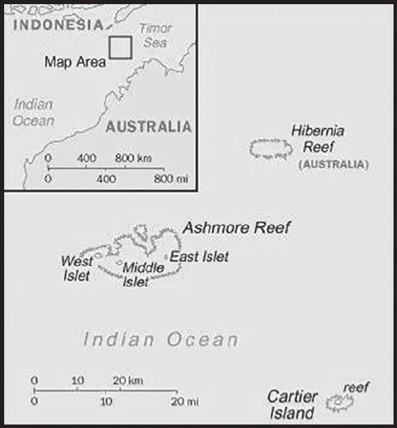
Location: Southeastern Asia, islands in the Indian Ocean, midway between northwestern Australia and Timor island; Ashmore Reef is 840 km west of Darwin and 610 km north of Broome; Cartier Islet is 70 km east of Ashmore Reef
Geographic coordinates: 12 25 S, 123 20 E
note - Ashmore Reef - 12 14 S, 123 05 E; Cartier Islet - 12 32 S, 123 32 E
Map references: Southeast Asia
Area: total: 5 sq km
land: 5 sq km
water: 0 sq km
note: includes Ashmore Reef (West, Middle, and East Islets) and Cartier Island
comparison ranking: total 248
Area - comparative: about eight times the size of the National Mall in Washington, DC
Land boundaries: total: 0 km
Coastline: 74.1 km
Maritime claims: territorial sea: 12 nm
contiguous zone: 24 nm
continental shelf: 200-m depth or to the depth of exploitation
exclusive fishing zone: 200 nm
Climate: tropical
Terrain: low with sand and coral
Elevation: highest point: Cartier Island 5 m
lowest point: Indian Ocean 0 m
Natural resources: fish
Land use: agricultural land: 0% (2018 est.)
Natural hazards: surrounded by shoals and reefs that can pose maritime hazards
Geography - note: Ashmore Reef National Nature Reserve established in August 1983; Cartier Island Marine Reserve established in 2000
PEOPLE AND SOCIETY
Population: (July 2021 est.) no indigenous inhabitants
note: Indonesian fishermen are allowed access to the lagoon and fresh water at Ashmore Reef’s West Island; access to East and Middle Islands is by permit only
Population growth rate: 0.32% (2021 est.)
ENVIRONMENT
Environment - current issues: illegal killing of protected wildlife by traditional Indonesian fisherman, as well as fishing by non-traditional Indonesian vessels, are ongoing problems; sea level rise, changes in sea temperature, and ocean acidification are concerns; marine debris
Climate: tropical
Land use: agricultural land: 0% (2018 est.)
GOVERNMENT
Country name: conventional long form: Territory of Ashmore and Cartier Islands
conventional short form: Ashmore and Cartier Islands
etymology: named after British Captain Samuel ASHMORE, who first sighted his namesake island in 1811, and after the ship Cartier, from which the second island was discovered in 1800
Dependency status: territory of Australia; administered from Canberra by the Department of Regional Australia, Local Government, Arts and Sport
Legal system: the laws of the Commonwealth of Australia and the laws of the Northern Territory of Australia, where applicable, apply
Citizenship: see Australia
Diplomatic representation in the US: none (territory of Australia)
Diplomatic representation from the US: embassy: none (territory of Australia)
Flag description: the flag of Australia is used
TRANSPORTATION
Ports and terminals: none; offshore anchorage only
MILITARY AND SECURITY
Military - note: defense is the responsibility of Australia; periodic visits by the Royal Australian Navy and Royal Australian Air Force
TRANSNATIONAL ISSUES
Disputes - international: Australia-Indonesia: Australia has closed parts of the Ashmore and Cartier reserve to Indonesian traditional fishing; Indonesian groups challenge Australia’s claim to Ashmore Reef
INTRODUCTION
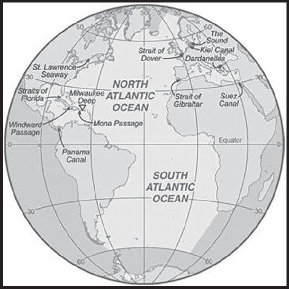
Background: The Atlantic Ocean is the second largest of the world’s five oceans (after the Pacific Ocean, but larger than the Indian Ocean, Southern Ocean, and Arctic Ocean). The Kiel Canal (Germany), Oresund (Denmark-Sweden), Bosporus (Turkey), Strait of Gibraltar (Morocco-Spain), and the Saint Lawrence Seaway (Canada-US) are important strategic access waterways. The decision by the International Hydrographic Organization in the spring of 2000 to delimit a fifth world ocean, the Southern Ocean, removed the portion of the Atlantic Ocean south of 60 degrees south latitude. For convenience and because of its immense size, the Atlantic Ocean is often divided at the Equator and designated as the North Atlantic Ocean and the South Atlantic Ocean.
GEOGRAPHY
Location: body of water between Africa, Europe, the Arctic Ocean, the Americas, and the Southern Ocean
Geographic coordinates: 0 00 N, 25 00 W
Map references: Political Map of the World
Area: total: 85.133 million sq km
note: includes Baffin Bay, Baltic Sea, Black Sea, Caribbean Sea, Davis Strait, Denmark Strait, part of the Drake Passage, Hudson Bay, Hudson Strait, Gulf of Mexico, Labrador Sea, Mediterranean Sea, North Sea, almost all of the Scotia Sea, and other tributary water bodies
Area - comparative: about 7.5 times the size of the US
Coastline: 111,866 km
Climate: tropical cyclones (hurricanes) develop off the coast of Africa near Cabo Verde and move westward into the Caribbean Sea; hurricanes can occur from May to December but are most frequent from August to November
Ocean volume:
ocean volume: 310,410,900 cu km
percent of World Ocean total volume: 23.3%
Major ocean currents: clockwise North Atlantic Gyre consists of the northward flowing, warm Gulf Stream in the west, the eastward flowing North Atlantic Current in the north, the southward flowing cold Canary Current in the east, and the westward flowing North Equatorial Current in the south; the counterclockwise South Atlantic Gyre composed of the southward flowing warm Brazil Current in the west, the eastward flowing South Atlantic Current in the south, the northward flowing cold Benguela Current in the east, and the westward flowing South Equatorial Current in the north
Elevation: highest point: sea level
lowest point: Puerto Rico Trench -8,605 m
mean depth: -3,646 m
ocean zones: Composed of water and in a fluid state, the oceans are delimited differently than the solid continents. Oceans are divided into three zones based on depth and light level. Although some sea creatures depend on light to live, others can do without it. Sunlight entering the water may travel about 1,000 m into the oceans under the right conditions, but there is rarely any significant light beyond 200 m.
The upper 200 m (656 ft) of oceans is called the euphotic, or “sunlight,” zone. This zone contains the vast majority of commercial fisheries and is home to many protected marine mammals and sea turtles. Only a small amount of light penetrates beyond this depth.
The zone between 200 m (656 ft) and 1,000 m (3,280 ft) is usually referred to as the “twilight” zone, but is officially the dysphotic zone. In this zone, the intensity of light rapidly dissipates as depth increases. Such a minuscule amount of light penetrates beyond a depth of 200 m that photosynthesis is no longer possible.
The aphotic, or “midnight,” zone exists in depths below 1,000 m (3,280 ft). Sunlight does not penetrate to these depths and the zone is bathed in darkness.
Distance Sunlight Travels in the Ocean:
Natural resources: oil and gas fields, fish, marine mammals (seals and whales), sand and gravel aggregates, placer deposits, polymetallic nodules, precious stones
Natural hazards: icebergs common in Davis Strait, Denmark Strait, and the northwestern Atlantic Ocean from February to August and have been spotted as far south as Bermuda and the Madeira Islands; ships subject to superstructure icing in extreme northern Atlantic from October to May; persistent fog can be a maritime hazard from May to September; hurricanes (May to December)
Geography - note: major chokepoints include the Dardanelles, Strait of Gibraltar, access to the Panama and Suez Canals; strategic straits include the Strait of Dover, Straits of Florida, Mona Passage, The Sound (Oresund), and Windward Passage; the Equator divides the Atlantic Ocean into the North Atlantic Ocean and South Atlantic Ocean
ENVIRONMENT
Environment - current issues: endangered marine species include the manatee, seals, sea lions, turtles, and whales; unsustainable exploitation of fisheries (over fishing, bottom trawling, drift net fishing, discards, catch of non-target species); pollution (maritime transport, discharges, offshore drilling, oil spills); municipal sludge pollution off eastern US, southern Brazil, and eastern Argentina; oil pollution in Caribbean Sea, Gulf of Mexico, Lake Maracaibo, Mediterranean Sea, and North Sea; industrial waste and municipal sewage pollution in Baltic Sea, North Sea, and Mediterranean Sea
Climate: tropical cyclones (hurricanes) develop off the coast of Africa near Cabo Verde and move westward into the Caribbean Sea; hurricanes can occur from May to December but are most frequent from August to November
Marine fisheries: the Atlantic Ocean fisheries are the second most important in the world accounting for 25.8%, or 20,300,000 mt, of the global catch in 2020; of the seven regions delineated by the Food and Agriculture Organization in the Atlantic basin, the most important include the following:
Northeast Atlantic region (Region 27) is the fourth most important in the world producing 10.5% of the global catch or 8,310,000 mt in 2020; the region encompasses the waters north of 36° North latitude and east of 40° West longitude with the major producers including Norway (3,528,240 mt), Russia (1,044,153 mt), Iceland (933,019 mt), UK (823,669 mt), and Denmark (641,927 mt); the region includes the historically important fishing grounds of the North Sea, the Baltic Sea, and the Atlantic waters between Greenland, Iceland, and the British Isles; the principal catches include Atlantic cod, haddock, saithe (pollock), Blue Whiting, herring, and mackerel; not all fish caught are for human consumption, half of fish catches in the North Sea are processed as fish oil or fish meal, which are used in animal fodder
Eastern Central Atlantic region (Region 34) is the second most important Atlantic fishery, and seventh largest in the world producing more than 6.3% of the global catch or 4,950,000 mt in 2020; the region encompasses the waters between 36° North and 6° South latitude and east of 40° West longitude off the west coast of Africa with the major producers including Morocco (1,419,872 mt), Mauritania (705,850 mt), Senegal (472,571 mt), Nigeria (451,768 mt), Ghana (303,001 mt), Cameroon (265,969 mt), and Sierra Leone (200,000 mt); the principal catches include pilchard, sardinellas, shad, and mackerel
Northwest Atlantic region (Region 21) is the fourth most important Atlantic fishery and eleventh in the world producing 1.9% of the global catch and 1,540,000 mt in 2020; it encompasses the waters north of 35° North latitude and west of 42° West longitude including the important fishing grounds over the continental shelf of North America such as the Grand Banks, the Georges Bank, and the Flemish Cap, as well as Baffin Bay with the major producers including the US (927,777 mt), Canada (615,651 mt), and Greenland (179,990 mt); the principal catches include sea scallops, prawns, lobster, herring, and menhaden
Mediterranean and Black Sea region (Region 37) is a minor fishing region representing 1.5% or 1,190,000 mt of the world’s total capture in 2020; the region encompasses all waters east of the Strait of Gibraltar with the major producers including Turkey (686,650 mt), Italy (281,212 mt), Tunisia (129,325 mt), Spain (119,759 mt), and Russia (72,279 mt); the principal catches include European anchovy, European pilchard, Gobies, and clams
Regional fisheries bodies: Commission for the Conservation of Southern Bluefin Tuna, Fishery Committee for the Eastern Central Atlantic, Fisheries Committee for the West Central Gulf of Guinea, General Fisheries Commission for the Mediterranean, International Commission for the Conservation of Atlantic Tunas, International Council for the Exploration of the Seas, Northwest Atlantic Fisheries Organization, North Atlantic Salmon Conservation Organization, North East Atlantic Fisheries Commission, Southeast Atlantic Fisheries Organization, Western Central Atlantic Fishery Commission
GOVERNMENT
Country name: etymology: name derives from the Greek description of the waters beyond the Strait of Gibraltar, Atlantis thalassa, meaning “Sea of Atlas”
TRANSPORTATION
Icebreakers: North Atlantic
Canada: one PC 3 or 4 class medium icebreaker
France: one PC 5 or 6 class light icebreaker
Germany: one PC 5 or 6 class light icebreaker
US: one PC 3 or 4 class medium icebreaker, and one PC 5 or 6 class light icebreaker
Baltic
Denmark: three PC 5 or 6 class light icebreakers
Estonia: two PC 5 or 6 class light icebreakers
Finland: seven PC 3 or 4 class medium icebreakers, and two PC 5 or 6 class light icebreakers Latvia: one PC 5 or 6 class light icebreaker
Russia: 22 PC 3 or 4 class medium icebreakers, and five PC 5 or 6 class light icebreakers Sweden: four PC 3 or 4 class medium icebreakers
Great Lakes/St Lawrence Seaway
Canada: one PC 3 or 4 class medium icebreaker, ten PC 5 or 6 class light icebreakers
Mediterranean
Italy: one PC 5 or 6 class light icebreaker
South Atlantic
Argentina: one PC 5 or 6 class light icebreaker
UK (Falkland Islands): one PC 3 or 4 class medium icebreaker
South Africa: one PC 5 or 6 class light icebreaker
note: the ships are listed by Polar Class (PC) vessel: PC 1 - year-round operation in all polar waters (ice thickness >3 m); PC 2 - year-round operation in moderate multi-year ice conditions (ice thickness up to 3 m); PC 3 - year-round operation in second-year ice which may include multi-year ice inclusions (ice thickness up to 2.5 m); PC 4 - year-round operation in thick first-year ice which may include old ice inclusions (ice thickness up to 120 cm); PC 5 - year-round operation in medium first-year ice which may include old ice inclusions (ice thickness up to 70-120 cm); PC 6 - summer/autumn operation in medium first-year ice which may include old ice inclusions (ice thickness up to 30-70 cm)
Ports and terminals: major seaport(s): Alexandria (Egypt), Algiers (Algeria), Antwerp (Belgium), Barcelona (Spain), Buenos Aires (Argentina), Casablanca (Morocco), Colon (Panama), Copenhagen (Denmark), Dakar (Senegal), Gdansk (Poland), Hamburg (Germany), Helsinki (Finland), Las Palmas (Canary Islands, Spain), Le Havre (France), Lisbon (Portugal), London (UK), Marseille (France), Montevideo (Uruguay), Montreal (Canada), Naples (Italy), New Orleans (US), New York (US), Oran (Algeria), Oslo (Norway), Peiraiefs or Piraeus (Greece), Rio de Janeiro (Brazil), Rotterdam (Netherlands), Saint Petersburg (Russia), Stockholm (Sweden)
Transportation - note: Kiel Canal and Saint Lawrence Seaway are two important waterways; significant domestic commercial and recreational use of Intracoastal Waterway on central and south Atlantic seaboard and Gulf of Mexico coast of US
MILITARY AND SECURITY
Military - note: according to the International Maritime Bureau and the Maritime Administration of the US Department of Transportation, the risk of piracy and armed robbery of ships in the territorial and offshore waters of the Niger Delta and Gulf of Guinea off the western coast of Africa is high; some criminals/pirates have operated as far as 200 nm offshore (2023)
TRANSNATIONAL ISSUES
Disputes - international: some maritime disputes (see littoral states)
INTRODUCTION
Background: Aboriginal Australians arrived on the continent at least 60,000 years ago and developed complex hunter-gatherer societies and oral histories. Dutch navigators led by Abel TASMAN were the first Europeans to land in Australia in 1606, and they mapped the western and northern coasts. They named the continent New Holland but made no attempts to permanently settle it. In 1770, English captain James COOK sailed to the east coast of Australia, named it New South Wales, and claimed it for Great Britain. In 1788 and 1825, Great Britain established New South Wales and then Tasmania as penal colonies respectively. Great Britain and Ireland sent more than 150,000 convicts to Australia before ending the practice in 1868. As Europeans began settling areas away from the coasts, they came into more direct contact with Aboriginal Australians. Europeans also cleared land for agriculture, impacting Aboriginal Australians’ ways of life. These issues, along with disease and a policy in the 1900s that forcefully removed Aboriginal children from their parents, reduced the Aboriginal Australian population from more than 700,000 pre-European contact to a low of 74,000 in 1933.
Four additional colonies were established in Australia in the mid-1800s: Western Australia (1829), South Australia (1836), Victoria (1851), and Queensland (1859). Gold rushes beginning in the 1850s brought thousands of new immigrants to New South Wales and Victoria, helping to reorient Australia away from its penal colony roots. In the second half of the 1800s, the colonies were all gradually granted self-government, and in 1901, they federated and became the Commonwealth of Australia. Australia contributed more than 400,000 troops to Allied efforts during World War I, and Australian troops played a large role in the defeat of Japanese troops in the Pacific in World War II. Australia severed most constitutional links with the UK in 1942, but remained part of the British Commonwealth. In 2021, Australia, the UK, and the US announced the AUKUS enhanced trilateral security partnership to maintain and expand the three countries’ edge in military capabilities and critical technologies. Australia’s post-war economy boomed and by the 1970s, racial policies that prevented most non-Whites from immigrating to Australia were removed, greatly increasing Asian immigration to the country. In recent decades, Australia has become an internationally competitive, advanced market economy due in large part to economic reforms adopted in the 1980s and its proximity to East and Southeast Asia.
In the early 2000s, Australian politics became unstable with frequent attempts to oust party leaders, including five changes of prime minister between 2010 and 2018. As a result, both major parties instituted rules to make it harder to remove a party leader.
GEOGRAPHY
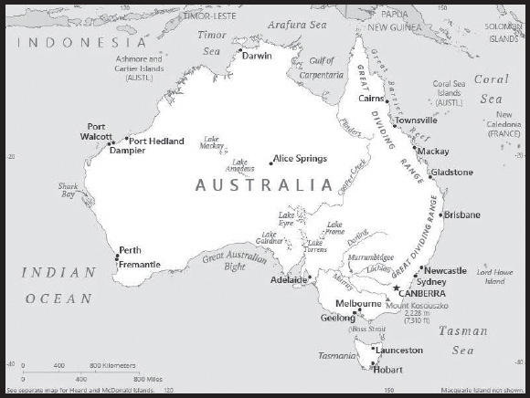
Location: Oceania, continent between the Indian Ocean and the South Pacific Ocean
Geographic coordinates: 27 00 S, 133 00 E
Map references: Oceania
Area: total: 7,741,220 sq km
land: 7,682,300 sq km
water: 58,920 sq km
note: includes Lord Howe Island and Macquarie Island
comparison ranking: total 7
Area - comparative: slightly smaller than the US contiguous 48 states
Land boundaries: total: 0 km
Coastline: 25,760 km
Maritime claims: territorial sea: 12 nm
contiguous zone: 24 nm
exclusive economic zone: 200 nm
continental shelf: 200 nm or to the edge of the continental margin
Climate: generally arid to semiarid; temperate in south and east; tropical in north
Terrain: mostly low plateau with deserts; fertile plain in southeast
Elevation: highest point: Mount Kosciuszko 2,228 m
lowest point: Lake Eyre -15 m
mean elevation: 330 m
Natural resources: alumina, coal, iron ore, copper, lithium, tin, gold, silver, uranium, nickel, tungsten, rare earth elements, mineral sands, lead, zinc, diamonds, opals, natural gas, petroleum
note 1: Australia is the world’s largest net exporter of coal accounting for 26.5% of global coal exports in 2021; coal is the country’s most abundant energy resource, and coal ranks as the second-largest export commodity from Australia in terms of revenue; in 2020, Australia held the third-largest recoverable coal reserves in the world behind the United States and Russia
note 2: Australia is by far the world’s largest supplier of opals
note 3: Australia holds the largest uranium reserves in the world, and was the second-largest global uranium producer behind Kazakhstan in 2020.
note 4: Australia was the largest exporter of LNG in the world in 2020.
Land use: agricultural land: 46.65% (2018 est.)
arable land: 4.03% (2018 est.)
permanent crops: 0.04% (2018 est.)
permanent pasture: 42.58% (2018 est.)
forest: 17.42% (2018 est.)
other: 33.42% (2018 est.)
Irrigated land: 15,210 sq km (2020)
Major lakes (area sq km): fresh water lake(s): Lake Alexandrina - 570 sq km
salt water lake(s): Lake Eyre - 9,690 sq km; Lake Torrens (ephemeral) - 5,780 sq km; Lake Gairdner - 4,470 sq km; Lake Mackay (ephemeral) - 3,494 sq km; Lake Frome - 2,410 sq km; Lake Amadeus (ephemeral) - 1,032 sq km
Major rivers (by length in km): River Murray - 2,508 km; Darling River - 1,545 km; Murrumbidgee River - 1,485 km; Lachlan River - 1,339 km; Cooper Creek - 1,113 km; Flinders River - 1,004 km
Major watersheds (area sq km):
Indian Ocean drainage: (Great Australian Bight) Murray-Darling (1,050,116 sq km)
Internal (endorheic basin) drainage: Lake Eyre (1,212,198 sq km)
Major aquifers: Great Artesian Basin, Canning Basin
Population distribution: population is primarily located on the periphery, with the highest concentration of people residing in the east and southeast; a secondary population center is located in and around Perth in the west; of the States and Territories, New South Wales has, by far, the largest population; the interior, or “outback”, has a very sparse population
Natural hazards: cyclones along the coast; severe droughts; forest fires
volcanism: volcanic activity on Heard and McDonald Islands
Geography - note: note 1: world’s smallest continent but sixth-largest country; the largest country in Oceania, the largest country entirely in the Southern Hemisphere, and the largest country without land borders
note 2: the Great Dividing Range that runs along eastern Australia is that continent’s longest mountain range and the third-longest land-based range in the world; the term “Great Dividing Range” refers to the fact that the mountains form a watershed crest from which all of the rivers of eastern Australia flow – east, west, north, and south
note 3: Australia is the only continent without glaciers; it is the driest inhabited continent on earth, making it particularly vulnerable to the challenges of climate change; the invigorating sea breeze known as the “Fremantle Doctor” affects the city of Perth on the west coast and is one of the most consistent winds in the world; Australia is home to 10% of the world’s biodiversity, and a great number of its flora and fauna exist nowhere else in the world
PEOPLE AND SOCIETY
Population: 26,461,166 (2023 est.)
comparison ranking: 54
Nationality: noun: Australian(s)
adjective: Australian
Ethnic groups: English 33%, Australian 29.9%, Irish 9.5%, Scottish 8.6%, Chinese 5.5%, Italian 4.4%, German 4%, Indian 3.1%, Australian Aboriginal 2.9%, Greek 1.7%, unspecified 4.7%
(2021 est.)
note: data represent self-identified ancestry, with the option of reporting two ancestries
Languages: English 72%, Mandarin 2.7%, Arabic 1.4%, Vietnamese 1.3%, Cantonese 1.2%, other 15.7%, unspecified 5.7% (2021 est.)
note: data represent language spoken at home
Religions: Roman Catholic 20%, Protestant 18.1% (Anglican 9.8%, Uniting Church 2.6%, Presbyterian and Reformed 1.6%, Baptist 1.4%, Pentecostal 1%, other Protestant 1.7%), other Christian 3.5%, Muslim 3.2%, Hindu 2.7%, Buddhist 2.4%, Orthodox 2.3% (Eastern Orthodox 2.1%, Oriental Orthodox 0.2%), other 2.1%, none 38.4%, unspecified 7.3% (2021 est.)
Age structure: 0-14 years: 18.43% (male 2,515,636/female 2,359,859)
15-64 years: 64.89% (male 8,602,204/female 8,568,004)
65 years and over: 16.69% (2023 est.) (male 2,034,383/female 2,381,080)
Dependency ratios: total dependency ratio: 53.7
youth dependency ratio: 28.2
elderly dependency ratio: 25.5
potential support ratio: 3.9 (2020 est.)
Median age: total: 37.5 years (2020)
male: 36.5 years
female: 38.5 years
comparison ranking: total 70
Population growth rate: 1.19% (2023 est.)
comparison ranking: 74
Birth rate: 12.23 births/1,000 population (2023 est.)
comparison ranking: 148
Death rate: 6.76 deaths/1,000 population (2023 est.)
comparison ranking: 126
Net migration rate: 6.39 migrant(s)/1,000 population (2023 est.)
comparison ranking: 14
Population distribution: population is primarily located on the periphery, with the highest concentration of people residing in the east and southeast; a secondary population center is located in and around Perth in the west; of the States and Territories, New South Wales has, by far, the largest population; the interior, or “outback”, has a very sparse population
Urbanization: urban population: 86.6% of total population (2023)
rate of urbanization: 1.27% annual rate of change (2020-25 est.)
note: data include Christmas Island, Cocos Islands, and Norfolk Island
Major urban areas - population: 5.235 million Melbourne, 5.121 million Sydney, 2.505 million Brisbane, 2.118 million Perth, 1.367 million Adelaide, 472,000 CANBERRA (capital) (2023)
Sex ratio: at birth: 1.06 male(s)/female
0-14 years: 1.07 male(s)/female
15-64 years: 1 male(s)/female
65 years and over: 0.85 male(s)/female
total population: 0.99 male(s)/female (2023 est.)
Mother’s mean age at first birth: 28.7 years (2019 est.)
Maternal mortality ratio: 3 deaths/100,000 live births (2020 est.)
comparison ranking: 176
Infant mortality rate: total: 2.96 deaths/1,000 live births (2023 est.)
male: 3.2 deaths/1,000 live births
female: 2.71 deaths/1,000 live births
comparison ranking: total 213
Life expectancy at birth: total population: 83.28 years (2023 est.)
male: 81.14 years
female: 85.54 years
comparison ranking: total population 14
Total fertility rate: 1.73 children born/woman (2023 est.)
comparison ranking: 159
Gross reproduction rate: 0.84 (2023 est.)
Contraceptive prevalence rate: 66.9% (2015/16)
note: percent of women aged 18-44
Drinking water source: improved: urban: 100% of population
rural: 100% of population
total: 100% of population
unimproved: urban: 0% of population
rural: 0% of population
total: 0% of population (2020 est.)
Current health expenditure: 10.7% of GDP (2020)
Physicians density: 4.13 physicians/1,000 population (2020)
Hospital bed density: 3.8 beds/1,000 population (2016)
Sanitation facility access: improved: total: 100% of population
unimproved: total: 0% of population (2020 est.)
Obesity - adult prevalence rate: 29% (2016)
comparison ranking: 27
Alcohol consumption per capita: total: 9.51 liters of pure alcohol (2019 est.)
beer: 3.71 liters of pure alcohol (2019 est.)
wine: 3.67 liters of pure alcohol (2019 est.)
spirits: 1.32 liters of pure alcohol (2019 est.)
other alcohols: 0.81 liters of pure alcohol (2019 est.)
comparison ranking: total 27
Tobacco use: total: 13.6% (2020 est.)
male: 15.6% (2020 est.)
female: 11.5% (2020 est.)
comparison ranking: total 114
Currently married women (ages 15-49): 55.9% (2023 est.)
Education expenditures: 6.1% of GDP (2020 est.)
comparison ranking: 38
School life expectancy (primary to tertiary education): total: 21 years
male: 20 years
female: 22 years (2020)
Youth unemployment rate (ages 15-24): total: 10.8% (2021 est.)
male: 12.7%
female: 8.9%
comparison ranking: total 148
ENVIRONMENT
Environment - current issues: soil erosion from overgrazing, deforestation, industrial development, urbanization, and poor farming practices; limited natural freshwater resources; soil salinity rising due to the use of poor quality water; drought, desertification; clearing for agricultural purposes threatens the natural habitat of many unique animal and plant species; disruption of the fragile ecosystem has resulted in significant floral extinctions; the Great Barrier Reef off the northeast coast, the largest coral reef in the world, is threatened by increased shipping and its popularity as a tourist site; overfishing, pollution, and invasive species are also problems
Environment - international agreements: party to: Antarctic-Environmental Protection, Antarctic-Marine Living Resources, Antarctic Seals, Antarctic Treaty, Biodiversity, Climate Change, Climate Change-Kyoto Protocol, Climate Change-Paris Agreement, Comprehensive Nuclear Test Ban, Desertification, Endangered Species, Environmental Modification, Hazardous Wastes, Law of the Sea, Marine Dumping-London Convention, Marine Dumping-London Protocol, Marine Life Conservation, Nuclear Test Ban, Ozone Layer Protection, Ship Pollution, Tropical Timber 2006, Wetlands, Whaling
signed, but not ratified: none of the selected agreements
Climate: generally arid to semiarid; temperate in south and east; tropical in north
Land use: agricultural land: 46.65% (2018 est.)
arable land: 4.03% (2018 est.)
permanent crops: 0.04% (2018 est.)
permanent pasture: 42.58% (2018 est.)
forest: 17.42% (2018 est.)
other: 33.42% (2018 est.)
Urbanization: urban population: 86.6% of total population (2023)
rate of urbanization: 1.27% annual rate of change (2020-25 est.)
note: data include Christmas Island, Cocos Islands, and Norfolk Island
Revenue from forest resources: 0.13% of GDP (2018 est.)
comparison ranking: 105
Revenue from coal: 0.78% of GDP (2018 est.)
comparison ranking: 7
Air pollutants: particulate matter emissions: 8.93 micrograms per cubic meter (2019 est.)
carbon dioxide emissions: 375.91 megatons (2016 est.)
methane emissions: 105.01 megatons (2020 est.)
Waste and recycling: municipal solid waste generated annually: 13.345 million tons (2015 est.)
municipal solid waste recycled annually: 5,618,245 tons (2015 est.)
percent of municipal solid waste recycled: 42.1% (2015 est.)
Major lakes (area sq km): fresh water lake(s): Lake Alexandrina - 570 sq km
salt water lake(s): Lake Eyre - 9,690 sq km; Lake Torrens (ephemeral) - 5,780 sq km; Lake Gairdner - 4,470 sq km; Lake Mackay (ephemeral) - 3,494 sq km; Lake Frome - 2,410 sq km; Lake Amadeus (ephemeral) - 1,032 sq km
Major rivers (by length in km): River Murray - 2,508 km; Darling River - 1,545 km; Murrumbidgee River - 1,485 km; Lachlan River - 1,339 km; Cooper Creek - 1,113 km; Flinders River - 1,004 km
Major watersheds (area sq km):
Indian Ocean drainage: (Great Australian Bight) Murray-Darling (1,050,116 sq km)
Internal (endorheic basin) drainage: Lake Eyre (1,212,198 sq km)
Major aquifers: Great Artesian Basin, Canning Basin
Total water withdrawal: municipal: 2.29 billion cubic meters (2020 est.)
industrial: 2.89 billion cubic meters (2020 est.)
agricultural: 8.57 billion cubic meters (2020 est.)
Total renewable water resources: 492 billion cubic meters (2020 est.)
GOVERNMENT
Country name: conventional long form: Commonwealth of Australia
conventional short form: Australia
etymology: the name Australia derives from the Latin “australis” meaning “southern”; the Australian landmass was long referred to as “Terra Australis” or the Southern Land
Government type: federal parliamentary democracy under a constitutional monarchy; a Commonwealth realm
Capital: name: Canberra
geographic coordinates: 35 16 S, 149 08 E
time difference: UTC+10 (14 hours ahead of Washington, DC, during Standard Time)
daylight saving time: +1hr, begins first Sunday in October; ends first Sunday in April
time zone note: Australia has four time zones, including Lord Howe Island (UTC+10:30)
etymology: the name is claimed to derive from either Kambera or Camberry, which are names corrupted from the original native designation for the area “Nganbra” or “Nganbira”
Administrative divisions: 6 states and 2 territories*; Australian Capital Territory*, New South Wales, Northern Territory*, Queensland, South Australia, Tasmania, Victoria, Western Australia
Dependent areas: Ashmore and Cartier Islands, Christmas Island, Cocos (Keeling) Islands, Coral Sea Islands, Heard Island and McDonald Islands, Norfolk Island (6)
Independence: 1 January 1901 (from the federation of UK colonies)
National holiday: Australia Day (commemorates the arrival of the First Fleet of Australian settlers), 26 January (1788); ANZAC Day (commemorates the anniversary of the landing of troops of the Australian and New Zealand Army Corps during World War I at Gallipoli, Turkey), 25 April (1915)
Constitution: history: approved in a series of referenda from 1898 through 1900 and became law 9 July 1900, effective 1 January 1901
amendments: proposed by Parliament; passage requires approval of a referendum bill by absolute majority vote in both houses of Parliament, approval in a referendum by a majority of voters in at least four states and in the territories, and Royal Assent; proposals that would reduce a state’s representation in either house or change a state’s boundaries require that state’s approval prior to Royal Assent; amended several times, last in 1977
Legal system: common law system based on the English model
International law organization participation: accepts compulsory ICJ jurisdiction with reservations; accepts ICCt jurisdiction
Citizenship: citizenship by birth: no
citizenship by descent only: at least one parent must be a citizen or permanent resident of Australia
dual citizenship recognized: yes
residency requirement for naturalization: 4 years
Suffrage: 18 years of age; universal and compulsory
Executive branch: chief of state: King CHARLES III (since 8 September 2022); represented by Governor General David HURLEY (since 1 July 2019)
head of government: Prime Minister Anthony ALBANESE (since 23 May 2022)
cabinet: Cabinet nominated by the prime minister from among members of Parliament and sworn in by the governor general
elections/appointments: the monarchy is hereditary; governor general appointed by the monarch on the recommendation of the prime minister; following legislative elections, the leader of the majority party or majority coalition is sworn in as prime minister by the governor general
Legislative branch: description: bicameral Federal Parliament consists of:
Senate (76 seats; 12 members from each of the 6 states and 2 each from the 2 mainland territories; members directly elected in multi-seat constituencies by proportional representation vote; members serve 6-year terms with one-half of state membership renewed every 3 years and territory membership renewed every 3 years)
House of Representatives (151 seats; members directly elected in single-seat constituencies by majority preferential vote; members serve terms of up to 3 years)
elections: Senate - last held on 21 May 2022 (next to be held in May 2025)
House of Representatives - last held on 21 May 2022 (next to be held in May 2025)
election results: Senate (initial results) - percent of vote by party - Liberal/National coalition 32.13%, ALP 29.81%, The Greens 13.85%, One Nation 4.38%, Lambie Network .26%; seats by party - Liberal/National coalition 29, ALP 21, The Greens 9, One Nation 1, Lambie Network 1, undecided 14
House of Representatives (initial results) - percent of vote by party - ALP 32.83%, Liberal/National coalition 35.77%, The Greens 11.85%, Katter’s Australian Party 0.4%, Centre Alliance 0.24%, independents 5.52%; seats by party - ALP 76, Liberal/National Coalition 57, The Greens 4, Katter’s Australian Party 1, Centre Alliance 1, independent 10, undecided 2
Judicial branch: highest court(s): High Court of Australia (consists of 7 justices, including the chief justice); note - each of the 6 states, 2 territories, and Norfolk Island has a Supreme Court; the High Court is the final appellate court beyond the state and territory supreme courts
judge selection and term of office: justices appointed by the governor-general in council for life with mandatory retirement at age 70
subordinate courts: subordinate courts: at the federal level: Federal Court; Federal Circuit and Family Court of Australia; at the state and territory level: Local Court - New South Wales; Magistrates’ Courts – Victoria, Queensland, South Australia, Western Australia, Tasmania, Northern Territory, Australian Capital Territory; District Courts – New South Wales, Queensland, South Australia, Western Australia; County Court – Victoria; Family Court – Western Australia; Court of Petty Sessions – Norfolk Island
Political parties and leaders: Australian Greens Party or The Greens [Adam BANDT]
Australian Labor Party or ALP [Anthony ALBANESE]
Centre Alliance (formerly known as the Nick Xenophon Team or NXT) [none]
Jacqui Lambie Network or JLN [Jacqui LAMBIE]
Katter’s Australian Party [Robbie KATTER]
Liberal Party of Australia [Peter DUTTON]
The Nationals [David LITTLEPROUD]
One Nation or ONP [Pauline HANSON]
note: the Labor Party is Australia’s oldest political party, established federally in 1901; the present Liberal Party was formed in 1944; the Country Party was formed in 1920, renamed the National Country Party in 1975, the National Party of Australia in 1982, and since 2003 has been known as the Nationals; since the general election of 1949, the Liberal Party and the Nationals (under various names) when forming government have done so as a coalition
International organization participation: ADB, ANZUS, APEC, ARF, ASEAN (dialogue partner), Australia Group, BIS, C, CD, CP, EAS, EBRD, EITI (implementing country), FAO, FATF, G-20, IAEA, IBRD, ICAO, ICC (national committees), ICCt, ICRM, IDA, IEA, IFC, IFRCS, IHO, ILO, IMF, IMO, IMSO, Interpol, IOC, IOM, IPU, ISO, ITSO, ITU, ITUC (NGOs), MIGA, NEA, NSG, OECD, OPCW, OSCE (partner), Pacific Alliance (observer), Paris Club, PCA, PIF, SAARC (observer), Quad, SICA (observer), Sparteca, SPC, UN, UNCTAD, UNESCO, UNHCR, UNMISS, UNMIT, UNRWA, UNTSO, UNWTO, UPU, Wassenaar Arrangement, WCO, WFTU (NGOs), WHO, WIPO, WMO, WTO, ZC
Diplomatic representation in the US: chief of mission: Ambassador Kevin Michael RUDD (since 19 April 2023)
chancery: temporary location: 1145 17th St NW, Washington DC, 20036-4707
note - new chancery building under construction at 1601 Massachusetts Avenue NW, Washington, DC 20036; formal opening scheduled for late 2023
telephone: [1] (202) 797-3000
FAX: [1] (202) 797-3168
email address and website: info.us@dfat.gov.au
consulate(s) general: Chicago, Honolulu, Houston, Los Angeles, New York, San Francisco
Diplomatic representation from the US: chief of mission: Ambassador Caroline KENNEDY (since 25 July 2022)
embassy: Moonah Place, Yarralumla, Australian Capital Territory 2600
mailing address: 7800 Canberra Place, Washington DC 20512-7800
telephone: [61] (02) 6214-5600
FAX: [61] (02) 9373-9184
email address and website: AskEmbassyCanberra@state.gov
consulate(s) general: Melbourne, Perth, Sydney
Flag description: blue with the flag of the UK in the upper hoist-side quadrant and a large seven-pointed star in the lower hoist-side quadrant known as the Commonwealth or Federation Star, representing the federation of the colonies of Australia in 1901; the star depicts one point for each of the six original states and one representing all of Australia’s internal and external territories; on the fly half is a representation of the Southern Cross constellation in white with one small, five-pointed star and four larger, seven-pointed stars
National symbol(s): Commonwealth Star (seven-pointed Star of Federation), golden wattle tree (Acacia pycnantha), kangaroo, emu; national colors: green, gold
Commonwealth Coat of Arms:
National anthem: name: Advance Australia Fair
lyrics/music: Peter Dodds McCORMICK
note 1: adopted 1984; although originally written in the late 19th century, the anthem was not used for all official occasions until 1984; as a Commonwealth country, in addition to the national anthem, “God Save the King” serves as the royal anthem (see United Kingdom)
note 2: the well-known and much-loved bush ballad “Waltzing Matilda” is often referred to as Australia’s unofficial national anthem; the original lyrics were written in 1895 by Australian poet Banjo PATERSON, and were first published as sheet music in 1903; since 2012, a Waltzing Matilda Day has been held annually on 6 April, the anniversary of the first performance of the song in 1895
National heritage: total World Heritage Sites: 20 (4 cultural, 12 natural, 4 mixed); note - includes one site on Heard Island and McDonald Islands
selected World Heritage Site locales: Great Barrier Reef (n); Greater Blue Mountains Area (n); Fraser Island (n); Gondwana Rainforests (n); Lord Howe Island Group (n); Royal Exhibition Building and Carlton Gardens (c); Shark Bay (n); Sydney Opera House (c); Uluru-Kata Tjuta National Park (m); Kakadu National Park (m)
ECONOMY
Economic overview: Asian and global economic leader and partner for 3 decades; strong financial sector and highly traded domestic currency support best credit ratings; aging workforce; export-led model; reduced consumer spending offset by government and business; energy investor
Real GDP (purchasing power parity): $1.279 trillion (2021 est.)
$1.251 trillion (2020 est.)
$1.251 trillion (2019 est.)
note: data are in 2017 dollars
comparison ranking: 20
Real GDP growth rate: 2.24% (2021 est.)
-0.05% (2020 est.)
2.17% (2019 est.)
comparison ranking: 158
Real GDP per capita: $49,800 (2021 est.)
$48,700 (2020 est.)
$49,400 (2019 est.)
note: data are in 2017 dollars
comparison ranking: 30
GDP (official exchange rate): $1,390,790,000,000 (2019 est.)
Inflation rate (consumer prices): 2.86% (2021 est.)
0.85% (2020 est.)
1.61% (2019 est.)
comparison ranking: 125
Credit ratings: Fitch rating: AAA (2011)
Moody’s rating: Aaa (2002)
Standard & Poors rating: AAA (2003)
note: The year refers to the year in which the current credit rating was first obtained.
GDP - composition, by sector of origin: agriculture: 3.6% (2017 est.)
industry: 25.3% (2017 est.)
services: 71.2% (2017 est.)
comparison rankings: services 63; industry 110; agriculture 145
GDP - composition, by end use: household consumption: 56.9% (2017 est.)
government consumption: 18.4% (2017 est.)
investment in fixed capital: 24.1% (2017 est.)
investment in inventories: 0.1% (2017 est.)
exports of goods and services: 21.5% (2017 est.)
imports of goods and services: -21% (2017 est.)
Agricultural products: sugar cane, wheat, barley, milk, rapeseed, beef, cotton, grapes, poultry, potatoes
Industries: mining, industrial and transportation equipment, food processing, chemicals, steel
Industrial production growth rate: -0.55% (2021 est.)
comparison ranking: 162
Labor force: 13.786 million (2021 est.)
comparison ranking: 46
Labor force - by occupation: agriculture: 3.6%
industry: 21.1%
services: 75.3% (2009 est.)
Unemployment rate: 5.11% (2021 est.)
6.46% (2020 est.)
5.16% (2019 est.)
comparison ranking: 147
Youth unemployment rate (ages 15-24): total: 10.8% (2021 est.)
male: 12.7%
female: 8.9%
comparison ranking: total 148
Gini Index coefficient - distribution of family income: 34.3 (2018 est.)
comparison ranking: 110
Average household expenditures: on food: 9.3% of household expenditures (2018 est.)
on alcohol and tobacco: 3.5% of household expenditures (2018 est.)
Household income or consumption by percentage share: lowest 10%: 2%
highest 10%: 25.4% (1994)
Budget: revenues: $479.33 billion (2019 est.)
expenditures: $532.579 billion (2019 est.)
Budget surplus (+) or deficit (-): -0.5% (of GDP) (2017 est.)
comparison ranking: 60
Public debt: 69.41% of GDP (2020 est.)
60.25% of GDP (2019 est.)
54.49% of GDP (2018 est.)
comparison ranking: 62
Taxes and other revenues: 22.61% (of GDP) (2020 est.)
comparison ranking: 66
Fiscal year: 1 July - 30 June
Current account balance: $56.261 billion (2021 est.)
$35.601 billion (2020 est.)
$7.658 billion (2019 est.)
comparison ranking: 13
Exports: $389.794 billion (2021 est.)
$300.77 billion (2020 est.)
$342.485 billion (2019 est.)
note: Data are in current year dollars and do not include illicit exports or re-exports.
comparison ranking: 21
Exports - partners: China 40%, Japan 14%, South Korea 9%, India 6%, Taiwan 4% (2021)
Exports - commodities: iron ore, coal, natural gas, gold, wheat (2021)
Imports: $298.712 billion (2021 est.) note: data are in current year dollars
$250.178 billion (2020 est.) note: data are in current year dollars
$295.504 billion (2019 est.) note: data are in current year dollars
comparison ranking: 23
Imports - partners: China 28%, United States 10%, Japan 6%, Germany 5%, Thailand 5% (2021)
Imports - commodities: refined petroleum, cars, delivery trucks, broadcasting equipment, computers and gold (2021)
Reserves of foreign exchange and gold: $57.878 billion (31 December 2021 est.)
$42.545 billion (31 December 2020 est.)
$57.995 billion (31 December 2019 est.)
comparison ranking: 40
Debt - external: $3,115,913,000,000 (2019 est.)
$2,837,818,000,000 (2018 est.)
comparison ranking: 8
Exchange rates: Australian dollars (AUD) per US dollar -
Exchange rates: 1.331 (2021 est.)
1.453 (2020 est.)
1.439 (2019 est.)
1.338 (2018 est.)
1.305 (2017 est.)
ENERGY
Electricity access: electrification - total population: 100% (2021)
Electricity: installed generating capacity: 82.517 million kW (2020 est.)
consumption: 237,388,272,000 kWh (2019 est.)
exports: 0 kWh (2020 est.)
imports: 0 kWh (2020 est.)
transmission/distribution losses: 12,607,778,000 kWh (2019 est.)
comparison rankings: imports 151; exports 139; installed generating capacity 16; transmission/distribution losses 28; consumption 19
Electricity generation sources: fossil fuels: 75.4% of total installed capacity (2020 est.)
nuclear: 0% of total installed capacity (2020 est.)
solar: 8.6% of total installed capacity (2020 est.)
wind: 8.4% of total installed capacity (2020 est.)
hydroelectricity: 6.2% of total installed capacity (2020 est.)
tide and wave: 0% of total installed capacity (2020 est.)
geothermal: 0% of total installed capacity (2020 est.)
biomass and waste: 1.4% of total installed capacity (2020 est.)
Coal: production: 504.051 million metric tons (2020 est.)
consumption: 99.048 million metric tons (2020 est.)
exports: 390.808 million metric tons (2020 est.)
imports: 583,000 metric tons (2020 est.)
proven reserves: 149.079 billion metric tons (2019 est.)
Petroleum: total petroleum production: 442,500 bbl/day (2021 est.)
refined petroleum consumption: 1,174,100 bbl/day (2019 est.)
crude oil and lease condensate exports: 197,700 bbl/day (2018 est.)
crude oil and lease condensate imports: 356,900 bbl/day (2018 est.)
crude oil estimated reserves: 2.446 billion barrels (2021 est.)
Refined petroleum products - production: 462,500 bbl/day (2017 est.)
comparison ranking: 35
Refined petroleum products - exports: 64,120 bbl/day (2017 est.)
comparison ranking: 48
Refined petroleum products - imports: 619,600 bbl/day (2017 est.)
comparison ranking: 12
Natural gas: production: 142,104,321,000 cubic meters (2020 est.)
consumption: 41,905,381,000 cubic meters (2020 est.)
exports: 101,766,728,000 cubic meters (2020 est.)
imports: 6,295,646,000 cubic meters (2020 est.)
proven reserves: 3,228,115,000,000 cubic meters (2021 est.)
note: Australia was the largest exporter of LNG in the world in 2020.
Carbon dioxide emissions: 417.87 million metric tonnes of CO2 (2019 est.)
from coal and metallurgical coke: 162.26 million metric tonnes of CO2 (2019 est.)
from petroleum and other liquids: 158.668 million metric tonnes of CO2 (2019 est.)
from consumed natural gas: 96.942 million metric tonnes of CO2 (2019 est.)
comparison ranking: total emissions 15
Energy consumption per capita: 241.004 million Btu/person (2019 est.)
comparison ranking: 16
COMMUNICATIONS
Telephones - fixed lines: total subscriptions: 4.6 million (2021 est.)
subscriptions per 100 inhabitants: 18 (2021 est.)
comparison ranking: total subscriptions 30
Telephones - mobile cellular: total subscriptions: 27.09 million (2021 est.)
subscriptions per 100 inhabitants: 105 (2021 est.)
comparison ranking: total subscriptions 48
Telecommunication systems: general assessment: the Australian telecom market since 2020 has been impacted by the pandemic, which forced many people to school and work from home and thus adopt fixed-line broadband services; internet traffic, both fixed and mobile, increased substantially as a result; in the fixed sector, there is an ongoing migration from copper-based platforms to fiber; the extension of fixed wireless access will mean that up to 120,000 premises currently dependent on satellite broadband will be able to access 5G-based fixed services; the fixed-line market has been falling steadily over the past five years; in the Australian fixed broadband market, there is a dynamic shift among customers to fiber networks; the DSL sector is steadily shrinking while subscribers on HFC infrastructure will continue to be provided by existing cable, with a steady migration to full fiber connectivity (2022)
domestic: 18 per 100 fixed-line telephone subscriptions and 105 per 100 mobile-cellular; more subscribers to mobile services than there are people; 90% of all mobile device sales are now smartphones, growth in mobile traffic brisk (2021)
international: country code - 61; landing points for more than 20 submarine cables including: the SeaMeWe-3 optical telecommunications submarine cable with links to Asia, the Middle East, and Europe; the INDIGO-Central, INDIGO West and ASC, North West Cable System, Australia-Papua New Guinea cable, CSCS, PPC-1, Gondwana-1, SCCN, Hawaiki, TGA, Basslink, Bass Strait-1, Bass Strait-2, JGA-S, with links to other Australian cities, New Zealand and many countries in southeast Asia, US and Europe; the H2 Cable, AJC, Telstra Endeavor, Southern Cross NEXT with links to Japan, Hong Kong, and other Pacific Ocean countries as well as the US; satellite earth stations - 10 Intelsat (4 Indian Ocean and 6 Pacific Ocean), 2 Inmarsat, 2 Globalstar, 5 other (2019)
Broadcast media: the Australian Broadcasting Corporation (ABC) runs multiple national and local radio networks and TV stations, as well as ABC Australia, a TV service that broadcasts in the Asia-Pacific region and is the main public broadcaster; Special Broadcasting Service (SBS), a second large public broadcaster, operates radio and TV networks broadcasting in multiple languages; several large national commercial TV networks, a large number of local commercial TV stations, and hundreds of commercial radio stations are accessible; cable and satellite systems are available (2022)
Internet country code: .au
Internet users: total: 24.96 million (2021 est.)
percent of population: 96% (2021 est.)
comparison ranking: total 34
Broadband - fixed subscriptions: total: 9,099,619 (2020 est.)
subscriptions per 100 inhabitants: 36 (2020 est.)
comparison ranking: total 23
TRANSPORTATION
National air transport system: number of registered air carriers: 25 (2020)
inventory of registered aircraft operated by air carriers: 583
annual passenger traffic on registered air carriers: 75,667,645 (2018)
annual freight traffic on registered air carriers: 2,027,640,000 (2018) mt-km
Civil aircraft registration country code prefix: VH
Airports: 418 (2021)
comparison ranking: total 19
Airports - with paved runways: 349
civil airports: 29
military airports: 17
joint use (civil-military) airports: 2
other airports: 301
note: paved runways have a concrete or asphalt surface but not all have facilities for refueling, maintenance, or air traffic control; the length of a runway required for aircraft to safely operate depends on a number of factors including the type of aircraft, the takeoff weight (including passengers, cargo, and fuel), engine types, flap settings, landing speed, elevation of the airport, and average maximum daily air temperature; paved runways can reach a length of 5,000 m (16,000 ft.), but the “typical” length of a commercial airline runway is between 2,500-4,000 m (8,000-13,000 ft.)
Airports - with unpaved runways: 131
note: unpaved runways have a surface composition such as grass or packed earth and are most suited to the operation of light aircraft; unpaved runways are usually short, often less than 1,000 m (3,280 ft.) in length; airports with unpaved runways often lack facilities for refueling, maintenance, or air traffic control
Heliports: 1 (2021)
Pipelines: 637 km condensate/gas, 30,054 km gas, 240 km liquid petroleum gas, 3,609 km oil, 110 km oil/gas/water, 72 km refined products (2013)
Railways: total: 36,064 km (2022) 3,448 km electrified
standard gauge: 18,007 km (2022) 1.435 mm
narrow gauge: 11,914 km (2022) 1.067 mm
broad gauge: 2,685 km (2022) 1.600 mm
other: 35 km (2015)
comparison ranking: total 7
Roadways: total: 873,573 km (2015)
urban: 145,928 km (2015)
non-urban: 727,645 km (2015)
comparison ranking: total 9
Waterways: 2,000 km (2011) (mainly used for recreation on Murray and Murray-Darling River systems)
comparison ranking: 44
Merchant marine: total: 587 (2022)
by type: bulk carrier 2, general cargo 77, oil tanker 6, other 502
comparison ranking: total 39
Ports and terminals: major seaport(s): Indian Ocean: Adelaide, Darwin, Fremantle, Geelong, Melbourne
Pacific Ocean: Brisbane, Cairns, Gladstone, Hobart, Newcastle, Port Port Kembla, Sydney
container port(s) (TEUs): Melbourne (2,909,288), Sydney (2,761,648) (2021)
LNG terminal(s) (export): Australia Pacific, Barrow Island, Burrup (Pluto), Curtis Island, Darwin, Karratha, Bladin Point (Ichthys), Gladstone, Prelude (offshore FLNG), Wheatstone
dry bulk cargo port(s): Dampier (iron ore), Dalrymple Bay (coal), Hay Point (coal), Port Hedland (iron ore), Port Walcott (iron ore)
Transportation - note: Australia operates one PC 3 or 4 class medium icebreaker based in Tasmania in support of operations in Antarctica note - PC indicates a Polar Class vessel: PC 3 - year-round operation in second-year ice which may include multi-year ice inclusions (ice thickness up to 2.5 m); PC 4 - year-round operation in thick first-year ice which may include old ice inclusions (ice thickness up to 120 cm)
MILITARY AND SECURITY
Military and security forces: Australian Defense Force (ADF): Australian Army, Royal Australian Navy, Royal Australian Air Force (2023)
note 1: the Army includes a Special Operations Command, while the Navy includes a Naval Aviation Force
note 2: the Australian Federal Police is an independent agency of the Attorney-General’s Department; it, along with state and territorial police forces are responsible for internal security; the Australian Border Force is under the Department of Home Affairs
Military expenditures: 2% of GDP (2023 est.)
2% of GDP (2022)
2.1% of GDP (2021)
2.1% of GDP (2020)
2% of GDP (2019)
comparison ranking: 59
Military and security service personnel strengths: approximately 60,000 active troops (30,000 Army; 15,000 Navy; 15,000 Air Force) (2023)
Military equipment inventories and acquisitions: the military’s inventory includes a mix of domestically produced and imported Western weapons systems; in recent years, the US has been the largest supplier of arms; the Australian defense industry produces a variety of land and sea weapons platforms; the defense industry also participates in joint development and production ventures with other Western countries, including the US and Canada (2023)
note: in 2023, the Australian defense ministry announced a new strategic review that called for the acquisition of more long-range deterrence capabilities, including missiles, submarines, and cyber tools
Military service age and obligation: 17 years of age (with parental consent) for voluntary military service for men and women; no conscription (abolished 1973) (2023)
note 1: foreign nationals who are permanent residents, particularly New Zealanders, or those who have applied for citizenship or overseas candidates who have appropriate experience and qualifications from an overseas military can apply to join the ADF
note 2: women have served in all roles, including combat arms, since 2013; in 2022, they comprised about 20% of the military
Military deployments: note: since the 1990s, Australia has deployed more than 30,000 personnel on nearly 100 UN peacekeeping and coalition military operations, including in Cambodia, Rwanda, the Solomon Islands, Somalia, and East Timor
Military - note: Australia has been part of the Australia, New Zealand, and US Security (ANZUS) Treaty since 1951; Australia is also a member of the Five Powers Defense Arrangements (FPDA), a series of mutual assistance agreements reached in 1971 embracing Australia, Malaysia, New Zealand, Singapore, and the UK; the FPDA commits the members to consult with one another in the event or threat of an armed attack on any of the members and to mutually decide what measures should be taken, jointly or separately; there is no specific obligation to intervene militarily
Australia has a long-standing military relationship with the US; Australian and US forces first fought together in France in 1918 at the Battle of Hamel, and have fought together in every major US conflict since; Australia and the US signed an agreement in 2014 that allowed for closer bi-lateral defense and security cooperation, including annual rotations of US Marines and enhanced rotations of US Air Force aircraft to Australia; Australian military forces train often with US forces; Australia has Major Non-NATO Ally (MNNA) status with the US, a designation under US law that provides foreign partners with certain benefits in the areas of defense trade and security cooperation
Australia also has long-standing defense and security ties to the UK, including a Defense and Security Cooperation Treaty signed in 2013; in 2020, Australia and the UK signed a memorandum of understanding to cooperate on the building of a next generation of frigates for their respective navies; the Australia-UK Ministerial Consultations (AUKMIN) is their premier bilateral forum on foreign policy, defense, and security issues
in 2021, Australia, the UK, and the US announced an enhanced trilateral security partnership called “AUKUS” which would build on existing bilateral ties, including deeper integration of defense and security-related science, technology, industrial bases, and supply chains, as well as deeper cooperation on a range of defense and security capabilities; the first initiative under AUKUS was a commitment to support Australia in acquiring conventionally armed nuclear-powered submarines for the Royal Australian Navy
the ADF is an experienced and professional force equipped with modern weapons; its missions include protecting Australia’s borders and maritime interests, responding to domestic natural disasters, and deploying overseas for humanitarian, peacekeeping, and other security-related missions; it trains regularly and participates in international exercises; the Army’s principal combat forces include a divisional headquarters with 3 mechanized brigades and a special operations command; the Navy operates over 40 surface craft and submarines, including 11 destroyers and frigates, two landing helicopter dock (LHD) amphibious assault ships, and six attack-type submarines; the RAF has an air combat group with more than 140 modern combat aircraft, as well as transport and surveillance air groups (2023)
SPACE
Space agency/agencies: Australian Space Agency (ASA; established 2018; headquarters opened in 2020); Defense Space Command (established 2022); Australian Space Office and Australian Space Board/Council (established 1987 and disbanded in 1996) (2023)
Space launch site(s): Whalers Way Orbital Launch Complex (commercial site, South Australia); Arnhem Space Center (commercial site, Northern Territory) (2023)
Space program overview: has a long history of involvement in space-related activities, including astronomy, rockets, satellites, and space tracking; develops, builds, operates, and tracks satellites, including communications, remote sensing (RS), navigational, and scientific/testing/research, often in partnership with other countries; develops other space technologies, including communications, RS capabilities, and telescopes; encouraging growth in domestic commercial space industry sector; cooperates with a variety of foreign space agencies and industries, including those of China, the European Space Agency/EU and their individual member states, Japan, New Zealand, South Korea, the UK, and the US; co-leads the Global Earth Observation System of Systems (2023)
note: further details about the key activities, programs, and milestones of the country’s space program, as well as government spending estimates on the space sector, appear in Appendix S
TERRORISM
Terrorist group(s): Terrorist group(s): Islamic State of Iraq and ash-Sham (ISIS)
note: details about the history, aims, leadership, organization, areas of operation, tactics, targets, weapons, size, and sources of support of the group(s) appear(s) in Appendix-T
TRANSNATIONAL ISSUES
Disputes - international: Australia-Indonesia (Maritime Boundary): All borders between Indonesia and Australia have been agreed upon bilaterally, but a 1997 treaty that would settle the last of their maritime and EEZ boundary has yet to be ratified by Indonesia’s legislature. Indonesian groups challenge Australia’s claim to Ashmore Reef. Australia closed parts of the Ashmore and Cartier reserve to Indonesian traditional fishing.
Refugees and internally displaced persons: refugees (country of origin): 12,180 (Iran), 8,741 (Afghanistan), 5,042 (Pakistan) (mid-year 2022)
stateless persons: 7,649 (2022)
Illicit drugs: amphetamine-type stimulants (ATS) and cannabis dominate the domestic illicit drug market and shown potential for expansion, with ATS accounting for the preponderance of detected imports; domestic heroin market is small, but also shown some growth; as of 2020, Malaysia was the primary embarkation point for heroin and ATS imports other than MDMA (ecstasy) for which South Korea was the primary embarkation point although MDMA is increasingly being produced domestically with number of detected labs nearly doubled. The US is the principal embarkation point for imported cannabis; Tasmania is one of the world’s major suppliers of licit opiate products; government maintains strict controls over areas of opium poppy cultivation and output of poppy straw concentrate; major consumer of cocaine and amphetamines
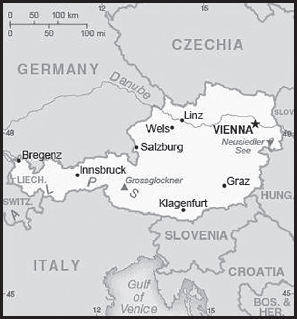
INTRODUCTION
Background: Once the center of power for the large Austro-Hungarian Empire, Austria was reduced to a small republic after its defeat in World War I. Following annexation by Nazi Germany in 1938 and subsequent occupation by the victorious Allies in 1945, Austria’s status remained unclear for a decade. A State Treaty signed in 1955 ended the occupation, recognized Austria’s independence, and forbade unification with Germany. A constitutional law that same year declared the country’s “perpetual neutrality” as a condition for Soviet military withdrawal. The Soviet Union’s collapse in 1991 and Austria’s entry into the EU in 1995 somewhat altered the meaning of this neutrality. A prosperous, democratic country, Austria entered the EU Economic and Monetary Union in 1999.
GEOGRAPHY
Location: Central Europe, north of Italy and Slovenia
Geographic coordinates: 47 20 N, 13 20 E
Map references: Europe
Area: total: 83,871 sq km
land: 82,445 sq km
water: 1,426 sq km
comparison ranking: total 114
Area - comparative: about the size of South Carolina; slightly more than two-thirds the size of Pennsylvania
Land boundaries: total: 2,524 km
border countries (8): Czech Republic 402 km; Germany 801 km; Hungary 321 km; Italy 404 km; Liechtenstein 34 km; Slovakia 105 km; Slovenia 299 km; Switzerland 158 km
Coastline: 0 km (landlocked)
Maritime claims: none (landlocked)
Climate: temperate; continental, cloudy; cold winters with frequent rain and some snow in lowlands and snow in mountains; moderate summers with occasional showers
Terrain: mostly mountains (Alps) in the west and south; mostly flat or gently sloping along the eastern and northern margins
Elevation: highest point: Grossglockner 3,798 m
lowest point: Neusiedler See 115 m
mean elevation: 910 m
Natural resources: oil, coal, lignite, timber, iron ore, copper, zinc, antimony, magnesite, tungsten, graphite, salt, hydropower
Land use: agricultural land: 38.4% (2018 est.)
arable land: 16.5% (2018 est.)
permanent crops: 0.8% (2018 est.)
permanent pasture: 21.1% (2018 est.)
forest: 47.2% (2018 est.)
other: 14.4% (2018 est.)
Irrigated land: 382 sq km (2016)
Major lakes (area sq km): fresh water lake(s): Lake Constance (shared with Switzerland and Germany) - 540 sq km
Major rivers (by length in km): Donau (Danube) (shared with Germany [s], Slovakia, Czechia, Hungary, Croatia, Serbia, Bulgaria, Ukraine, Moldova, and Romania [m]) - 2,888 km
note – [s] after country name indicates river source; [m] after country name indicates river mouth
Major watersheds (area sq km): Atlantic Ocean drainage: Rhine-Maas (198,735 sq km), (Black Sea) Danube (795,656 sq km)
Population distribution: the northern and eastern portions of the country are more densely populated; nearly two-thirds of the populace lives in urban areas
Natural hazards: landslides; avalanches; earthquakes
Geography - note: note 1: landlocked; strategic location at the crossroads of central Europe with many easily traversable Alpine passes and valleys; major river is the Danube; population is concentrated on eastern lowlands because of steep slopes, poor soils, and low temperatures elsewhere
note 2: the world’s largest and longest ice cave system at 42 km (26 mi) is the Eisriesenwelt (Ice Giants World) inside the Hochkogel mountain near Werfen, about 40 km south of Salzburg; ice caves are bedrock caves that contain year-round ice formations; they differ from glacial caves, which are transient and are formed by melting ice and flowing water within and under glaciers
PEOPLE AND SOCIETY
Population: 8,940,860 (2023 est.)
comparison ranking: 99
Nationality: noun: Austrian(s)
adjective: Austrian
Ethnic groups: Austrian 80.8%, German 2.6%, Bosnian and Herzegovinian 1.9%, Turkish 1.8%, Serbian 1.6%, Romanian 1.3%, other 10% (2018 est.)
note: data represent population by country of birth
Languages: German (official nationwide) 88.6%, Turkish 2.3%, Serbian 2.2%, Croatian (official in Burgenland) 1.6%, other (includes Slovene, official in southern Carinthia, and Hungarian, official in Burgenland) 5.3% (2001 est.)
major-language sample(s): Das World Factbook, die unverzichtbare Quelle für grundlegende Informationen. (German)
Religions: Roman Catholic 55.2%, Muslim 8.3%, Orthodox 4.9%, Evangelical Christian 3.8%, Jewish 0.1%, other 5.4%, none 22.4% (2021 est.)
note: data on Muslim is a 2016 estimate; data on other/none/unspecified are from 2012-2018 estimates
Age structure: 0-14 years: 14.08% (male 645,660/female 613,399)
15-64 years: 65.11% (male 2,914,056/female 2,907,233)
65 years and over: 20.81% (2023 est.) (male 820,022/female 1,040,490)
Dependency ratios: total dependency ratio: 51.1
youth dependency ratio: 21.7
elderly dependency ratio: 29.4
potential support ratio: 3.4 (2021 est.)
Median age: total: 44.5 years (2020)
male: 43.1 years
female: 45.8 years
comparison ranking: total 14
Population growth rate: 0.31% (2023 est.)
comparison ranking: 166
Birth rate: 9.39 births/1,000 population (2023 est.)
comparison ranking: 193
Death rate: 9.86 deaths/1,000 population (2023 est.)
comparison ranking: 37
Net migration rate: 3.54 migrant(s)/1,000 population (2023 est.)
comparison ranking: 34
Population distribution: the northern and eastern portions of the country are more densely populated; nearly two-thirds of the populace lives in urban areas
Urbanization: urban population: 59.5% of total population (2023)
rate of urbanization: 0.68% annual rate of change (2020-25 est.)
Major urban areas - population: 1.975 million VIENNA (capital) (2023)
Sex ratio: at birth: 1.05 male(s)/female
0-14 years: 1.05 male(s)/female
15-64 years: 1 male(s)/female
65 years and over: 0.79 male(s)/female
total population: 0.96 male(s)/female (2023 est.)
Mother’s mean age at first birth: 29.7 years (2020 est.)
Maternal mortality ratio: 5 deaths/100,000 live births (2020 est.)
comparison ranking: 168
Infant mortality rate: total: 3.2 deaths/1,000 live births (2023 est.)
male: 3.6 deaths/1,000 live births
female: 2.77 deaths/1,000 live births
comparison ranking: total 205
Life expectancy at birth: total population: 82.48 years (2023 est.)
male: 79.86 years
female: 85.23 years
comparison ranking: total population 25
Total fertility rate: 1.51 children born/woman (2023 est.)
comparison ranking: 202
Gross reproduction rate: 0.74 (2023 est.)
Contraceptive prevalence rate: 79% (2019)
note: percent of women aged 16-49
Drinking water source: improved: urban: 100% of population
rural: 100% of population
total: 100% of population
unimproved: urban: 0% of population
rural: 0% of population
total: 0% of population (2020 est.)
Current health expenditure: 11.5% of GDP (2020)
Physicians density: 5.29 physicians/1,000 population (2020)
Hospital bed density: 7.3 beds/1,000 population (2018)
Sanitation facility access: improved: urban: 100% of population
rural: 100% of population
total: 100% of population
unimproved: urban: 0% of population
rural: 0% of population
total: 0% of population (2020 est.)
Obesity - adult prevalence rate: 20.1% (2016)
comparison ranking: 105
Alcohol consumption per capita: total: 11.9 liters of pure alcohol (2019 est.)
beer: 6.3 liters of pure alcohol (2019 est.)
wine: 3.7 liters of pure alcohol (2019 est.)
spirits: 1.9 liters of pure alcohol (2019 est.)
other alcohols: 0 liters of pure alcohol (2019 est.)
comparison ranking: total 5
Tobacco use: total: 26.4% (2020 est.)
male: 27.7% (2020 est.)
female: 25% (2020 est.)
comparison ranking: total 42
Children under the age of 5 years underweight: NA
Currently married women (ages 15-49): 58.7% (2023 est.)
Education expenditures: 5.1% of GDP (2020 est.)
comparison ranking: 72
School life expectancy (primary to tertiary education): total: 16 years
male: 16 years
female: 16 years (2020)
Youth unemployment rate (ages 15-24): total: 11.4% (2021 est.)
male: 11.5%
female: 11.3%
comparison ranking: total 141
ENVIRONMENT
Environment - current issues: some forest degradation caused by air and soil pollution; soil pollution results from the use of agricultural chemicals; air pollution results from emissions by coal- and oil-fired power stations and industrial plants and from trucks transiting Austria between northern and southern Europe; water pollution; the Danube, as well as some of Austria’s other rivers and lakes, are threatened by pollution
Environment - international agreements: party to: Air Pollution, Air Pollution-Heavy Metals, Air Pollution-Nitrogen Oxides, Air Pollution-Persistent Organic Pollutants, Air Pollution-Sulphur 85, Air Pollution-Sulphur 94, Air Pollution-Volatile Organic Compounds, Antarctic Treaty, Biodiversity, Climate Change, Climate Change-Kyoto Protocol, Climate Change-Paris Agreement, Comprehensive Nuclear Test Ban, Desertification, Endangered Species, Environmental Modification, Hazardous Wastes, Law of the Sea, Nuclear Test Ban, Ozone Layer Protection, Ship Pollution, Tropical Timber 2006, Wetlands, Whaling
signed, but not ratified: Air Pollution-Multi-effect Protocol, Antarctic-Environmental Protection
Climate: temperate; continental, cloudy; cold winters with frequent rain and some snow in lowlands and snow in mountains; moderate summers with occasional showers
Land use: agricultural land: 38.4% (2018 est.)
arable land: 16.5% (2018 est.)
permanent crops: 0.8% (2018 est.)
permanent pasture: 21.1% (2018 est.)
forest: 47.2% (2018 est.)
other: 14.4% (2018 est.)
Urbanization: urban population: 59.5% of total population (2023)
rate of urbanization: 0.68% annual rate of change (2020-25 est.)
Revenue from forest resources: 0.07% of GDP (2018 est.)
comparison ranking: 123
Revenue from coal: 0% of GDP (2018 est.)
comparison ranking: 100
Air pollutants: particulate matter emissions: 11.51 micrograms per cubic meter (2019 est.)
carbon dioxide emissions: 61.45 megatons (2016 est.)
methane emissions: 6.34 megatons (2020 est.)
Waste and recycling: municipal solid waste generated annually: 4.836 million tons (2015 est.)
municipal solid waste recycled annually: 1,240,918 tons (2015 est.)
percent of municipal solid waste recycled: 25.7% (2015 est.)
Major lakes (area sq km): fresh water lake(s): Lake Constance (shared with Switzerland and Germany) - 540 sq km
Major rivers (by length in km): Donau (Danube) (shared with Germany [s], Slovakia, Czechia, Hungary, Croatia, Serbia, Bulgaria, Ukraine, Moldova, and Romania [m]) - 2,888 km
note – [s] after country name indicates river source; [m] after country name indicates river mouth
Major watersheds (area sq km): Atlantic Ocean drainage: Rhine-Maas (198,735 sq km), (Black Sea) Danube (795,656 sq km)
Total water withdrawal: municipal: 720 million cubic meters (2020 est.)
industrial: 2.7 billion cubic meters (2020 est.)
agricultural: 720 million cubic meters (2020 est.)
Total renewable water resources: 77.7 billion cubic meters (2020 est.)
GOVERNMENT
Country name: conventional long form: Republic of Austria
conventional short form: Austria
local long form: Republik Oesterreich
local short form: Oesterreich
etymology: the name Oesterreich means “eastern realm” and dates to the 10th century; the designation refers to the fact that Austria was the easternmost extension of Bavaria, and, in fact, of all the Germans; the word Austria is a Latinization of the German name
Government type: federal parliamentary republic
Capital: name: Vienna
geographic coordinates: 48 12 N, 16 22 E
time difference: UTC+1 (6 hours ahead of Washington, DC, during Standard Time)
daylight saving time: +1hr, begins last Sunday in March; ends last Sunday in October
etymology: the origin of the name is disputed but may derive from early Celtic settlements of the area; a plausible reconstructed Celtic name from several centuries B.C. is Vedunia (meaning “forest stream”), which in Old High German became uuenia (wenia), and later wien (its current German form) in New High German; another possibility is that the name stems from the Roman settlement Vindobona, established around 15 B.C., and its Celtic-derived name (likely from the Celtic windo, meaning “white, fair, or bright” and bona meaning “base, fortification, or settlement” to give a connotation of “white settlement” or “white fort”); archeological remains of the latter survive at many sites in the center of Vienna
Administrative divisions: 9 states (Bundeslaender, singular - Bundesland); Burgenland, Kaernten (Carinthia), Niederoesterreich (Lower Austria), Oberoesterreich (Upper Austria), Salzburg, Steiermark (Styria), Tirol (Tyrol), Vorarlberg, Wien (Vienna)
Independence: no official date of independence: 976 (Margravate of Austria established); 17 September 1156 (Duchy of Austria founded); 6 January 1453 (Archduchy of Austria acknowledged); 11 August 1804 (Austrian Empire proclaimed); 30 March 1867 (Austro-Hungarian dual monarchy established); 12 November 1918 (First Republic proclaimed); 27 April 1945 (Second Republic proclaimed)
National holiday: National Day (commemorates passage of the law on permanent neutrality), 26 October (1955)
Constitution: history: several previous; latest adopted 1 October 1920, revised 1929, replaced May 1934, replaced by German Weimar constitution in 1938 following German annexation, reinstated 1 May 1945
amendments: proposed through laws designated “constitutional laws” or through the constitutional process if the amendment is part of another law; approval required by at least a two-thirds majority vote by the National Assembly and the presence of one-half of the members; a referendum is required only if requested by one-third of the National Council or Federal Council membership; passage by referendum requires absolute majority vote; amended many times, last in 2020
Legal system: civil law system; judicial review of legislative acts by the Constitutional Court
International law organization participation: accepts compulsory ICJ jurisdiction; accepts ICCt jurisdiction
Citizenship: citizenship by birth: no
citizenship by descent only: at least one parent must be a citizen of Austria
dual citizenship recognized: no
residency requirement for naturalization: 10 years
Suffrage: 16 years of age; universal
Executive branch: chief of state: President Alexander VAN DER BELLEN (since 26 January 2017); note - President Alexander VAN DER BELLEN reelected to a second six-year term on 9 October 2022
head of government: Chancellor Karl NEHAMMER (since 6 December 2021)
cabinet: Council of Ministers proposed by the chancellor and appointed by the president
elections/appointments: president directly elected by absolute majority popular vote in 2 rounds if needed for a 6-year term (eligible for a second term); election last held on 9 October 2022; (next election to be held in 2028); chancellor appointed by the president but determined by the majority coalition parties in the Federal Assembly; vice chancellor appointed by the president on the advice of the chancellor
election results: 2022: Alexander VAN DER BELLEN elected in first round; percent of vote - Alexander VAN DER BELLEN (the Greens) 56.7%, Walter ROSENKRANZ (FPO) 17.7%, Dominik WLAZNY (Beer) 8.3%, Tassilo WALLENTIN (independent) 8.1%, Gerald GROSZ (independent) 5.6%
2016: Alexander VAN DER BELLEN elected in second round; percent of vote in first round - Norbert HOFER (FPOe) 35.1%, Alexander VAN DER BELLEN (independent, allied with the Greens) 21.3%, Irmgard GRISS (independent) 18.9%, Rudolf HUNDSTORFER (SPOe) 11.3%, Andreas KHOL (OeVP) 11.1%, Richard LUGNER (independent) 2.3%; percent of vote in second round - Alexander VAN DER BELLEN 53.8%, Norbert HOFER 46.2%
Legislative branch: description: bicameral Federal Assembly or Bundesversammlung consists of:
Federal Council or Bundesrat (61 seats - currently 60; members appointed by state parliaments with each state receiving 3 to 12 seats in proportion to its population; members serve 5- or 6-year terms)
National Council or Nationalrat (183 seats; members directly elected in single-seat constituencies by proportional representation vote; members serve 5-year terms)
elections: Federal Council - last appointed in 2021
National Council - last held on 29 September 2019 (next to be held in 2024); note - election was originally scheduled for 2022, but President VAN DER BELLEN called for an early election
election results: Federal Council - percent of vote by party - OeVP 42.6%, SPOe 31.2%. FPOe 16.4%, The Greens 8.2%, NEOS 1.6%; seats by party - OeVP 26, SPOe 19, FPOe 10, The Greens 5, NEOS 1; composition (as of August 2023) - men 31, women 29, percent of women 48.3%
National Council - percent of vote by party - OeVP 37.5%, SPOe 21.2%, FPOe 16.2%, The Greens 13.9%, NEOS 8.1%, other 3.1%; seats by party - OeVP 71, SPOe 40, FPOe 31, The Greens 26, NEOS 15; composition (as of August 2023) - men 110, women 73, percent of women 39.9%; note - total Federal Assembly percentage of women 42%
Judicial branch: highest court(s): Supreme Court of Justice or Oberster Gerichtshof (consists of 85 judges organized into 17 senates or panels of 5 judges each); Constitutional Court or Verfassungsgerichtshof (consists of 20 judges including 6 substitutes; Administrative Court or Verwaltungsgerichtshof - 2 judges plus other members depending on the importance of the case)
judge selection and term of office: Supreme Court judges nominated by executive branch departments and appointed by the president; judges serve for life; Constitutional Court judges nominated by several executive branch departments and approved by the president; judges serve for life; Administrative Court judges recommended by executive branch departments and appointed by the president; terms of judges and members determined by the president
subordinate courts: Courts of Appeal (4); Regional Courts (20); district courts (120); county courts
Political parties and leaders: Austrian People’s Party or OeVP [Karl NEHAMMER]
Freedom Party of Austria or FPOe [Herbert KICKL]
The Greens - The Green Alternative [Werner KOGLER]
NEOS - The New Austria and Liberal Forum [Beate MEINL-REISINGER]
Social Democratic Party of Austria or SPOe [Pamela RENDI-WAGNER]
International organization participation: ADB (nonregional member), AfDB (nonregional member), Australia Group, BIS, BSEC (observer), CD, CE, CEI, CERN, EAPC, EBRD, ECB, EIB, EMU, ESA, EU, FAO, FATF, G-9, IADB, IAEA, IBRD, ICAO, ICC (national committees), ICCt, ICRM, IDA, IEA, IFAD, IFC, IFRCS, IGAD (partners), ILO, IMF, IMO, Interpol, IOC, IOM, IPU, ISO, ITSO, ITU, ITUC (NGOs), MIGA, MINURSO, NEA, NSG, OAS (observer), OECD, OIF (observer), OPCW, OSCE, Paris Club, PCA, PFP, Schengen Convention, SELEC (observer), UN, UNCTAD, UNESCO, UNFICYP, UNHCR, UNIDO, UNIFIL, UNTSO, UNWTO, UPU, Wassenaar Arrangement, WCO, WFTU (NGOs), WHO, WIPO, WMO, WTO, ZC
Diplomatic representation in the US: chief of mission: Ambassador Petra SCHNEEBAUER (since 19 APRIL 2023)
chancery: 3524 International Court NW, Washington, DC 20008-3035
telephone: [1] (202) 895-6700
FAX: [1] (202) 895-6750
email address and website: washington-ob@bmeia.gv.at
consulate(s) general: Los Angeles, New York, Washington
consulate(s): Chicago
Diplomatic representation from the US: chief of mission: Ambassador Victoria Reggie KENNEDY (since 12 January 2022)
embassy: Boltzmanngasse 16, 1090, Vienna
mailing address: 9900 Vienna Place, Washington DC 20521-9900
telephone: [43] (1) 31339-0
FAX: [43] (1) 310-06-82
email address and website: ConsulateVienna@state.gov
Flag description: three equal horizontal bands of red (top), white, and red; the flag design is certainly one of the oldest - if not the oldest - national banners in the world; according to tradition, in 1191, following a fierce battle in the Third Crusade, Duke Leopold V of Austria’s white tunic became completely blood-spattered; upon removal of his wide belt or sash, a white band was revealed; the red-white-red color combination was subsequently adopted as his banner
National symbol(s): eagle, edelweiss, Alpine gentian; national colors: red, white
National anthem: name: “Bundeshymne” (Federal Hymn)
lyrics/music: Paula von PRERADOVIC/Wolfgang Amadeus MOZART or Johann HOLZER (disputed)
note 1: adopted 1947; the anthem is also known as “Land der Berge, Land am Strome” (Land of the Mountains, Land by the River); Austria adopted a new national anthem after World War II to replace the former imperial anthem composed by Franz Josef HAYDN, which had been appropriated by Germany in 1922 and was thereafter associated with the Nazi regime; a gender-neutral version of the lyrics was adopted by the Austrian Federal Assembly in fall 2011 and became effective 1 January 2012
note 2: the beloved waltz “The Blue Danube” (“An der schoenen, blauen Donau”), composed in 1866 by the Austrian composer Johann STRAUSS II, is consistently referred to as Austria’s unofficial national anthem
National heritage: total World Heritage Sites: 12 (11 cultural, 1 natural)
selected World Heritage Site locales: Historic Salzburg (c); Palace and Gardens of Schönbrunn (c); Halstadt–Dachstein/Salzkammergut Cultural Landscape (c); Semmering railway (c); Historic Graz and Schloss Eggenberg (c); Wachau Cultural Landscape (c); Historic Vienna (c); Fertő/Neusiedlersee Cultural Landscape (c); Baden bei Wien (c); Primeval Beech Forests - Dürrenstein, Kalkalpen (n)
ECONOMY
Economic overview: one of the strongest EU and euro economies; diversified trade portfolios and relations; enormous trade economy; Russian energy dependence, but investing in alternative energy; aging labor force but large refugee population; large government debt
Real GDP (purchasing power parity): $484.698 billion (2021 est.)
$463.574 billion (2020 est.)
$495.557 billion (2019 est.)
note: data are in 2017 dollars
comparison ranking: 44
Real GDP growth rate: 4.56% (2021 est.)
-6.45% (2020 est.)
1.52% (2019 est.)
comparison ranking: 102
Real GDP per capita: $54,100 (2021 est.)
$52,000 (2020 est.)
$55,800 (2019 est.)
note: data are in 2017 dollars
comparison ranking: 24
GDP (official exchange rate): $445.025 billion (2019 est.)
Inflation rate (consumer prices): 2.77% (2021 est.)
1.38% (2020 est.)
1.53% (2019 est.)
comparison ranking: 126
Credit ratings: Fitch rating: AA+ (2015)
Moody’s rating: Aa1 (2016)
Standard & Poors rating: AA+ (2012)
note: The year refers to the year in which the current credit rating was first obtained.
GDP - composition, by sector of origin: agriculture: 1.3% (2017 est.)
industry: 28.4% (2017 est.)
services: 70.3% (2017 est.)
comparison rankings: services 66; industry 90; agriculture 191
GDP - composition, by end use: household consumption: 52.1% (2017 est.)
government consumption: 19.5% (2017 est.)
investment in fixed capital: 23.5% (2017 est.)
investment in inventories: 1.6% (2017 est.)
exports of goods and services: 54.2% (2017 est.)
imports of goods and services: -50.7% (2017 est.)
Agricultural products: milk, maize, sugar beet, wheat, barley, potatoes, pork, triticale, grapes, apples
Industries: construction, machinery, vehicles and parts, food, metals, chemicals, lumber and paper, electronics, tourism
Industrial production growth rate: 6.77% (2021 est.)
comparison ranking: 64
Labor force: 4.661 million (2021 est.)
comparison ranking: 90
Labor force - by occupation: agriculture: 0.7%
industry: 25.2%
services: 74.1% (2017 est.)
Unemployment rate: 6.3% (2021 est.)
5.36% (2020 est.)
4.49% (2019 est.)
comparison ranking: 126
Youth unemployment rate (ages 15-24): total: 11.4% (2021 est.)
male: 11.5%
female: 11.3%
comparison ranking: total 141
Population below poverty line: 13.3% (2018 est.)
Gini Index coefficient - distribution of family income: 30.2 (2019 est.)
comparison ranking: 148
Average household expenditures: on food: 9.8% of household expenditures (2018 est.)
on alcohol and tobacco: 3.2% of household expenditures (2018 est.)
Household income or consumption by percentage share: lowest 10%: 2.8%
highest 10%: 23.5% (2012 est.)
Budget: revenues: $218.48 billion (2019 est.)
expenditures: $215.485 billion (2019 est.)
Budget surplus (+) or deficit (-): -0.7% (of GDP) (2017 est.)
comparison ranking: 68
Public debt: 99.91% of GDP (2020 est.)
83.05% of GDP (2019 est.)
84.16% of GDP (2018 est.)
note: this is general government gross debt, defined in the Maastricht Treaty as consolidated general government gross debt at nominal value, outstanding at the end of the year; it covers the following categories of government liabilities (as defined in ESA95): currency and deposits (AF.2), securities other than shares excluding financial derivatives (AF.3, excluding AF.34), and loans (AF.4); the general government sector comprises the sub-sectors of central government, state government, local government and social security funds; as a percentage of GDP, the GDP used as a denominator is the gross domestic product in current year prices
comparison ranking: 25
Taxes and other revenues: 24.19% (of GDP) (2020 est.)
comparison ranking: 57
Fiscal year: calendar year
Current account balance: $1.627 billion (2021 est.)
$12.897 billion (2020 est.)
$10.636 billion (2019 est.)
comparison ranking: 46
Exports: $268.277 billion (2021 est.)
$224.734 billion (2020 est.)
$247.738 billion (2019 est.)
note: Data are in current year dollars and do not include illicit exports or re-exports.
comparison ranking: 30
Exports - partners: Germany 28%, United States 7%, Italy 6%, Switzerland 5% (2019)
Exports - commodities: vaccines and cultures, cars, packaged medicines, vehicle parts, broadcasting equipment (2021)
Imports: $265.769 billion (2021 est.) note: data are in current year dollars
$211.736 billion (2020 est.) note: data are in current year dollars
$231.992 billion (2019 est.) note: data are in current year dollars
comparison ranking: 27
Imports - partners: Germany 39%, Italy 7%, Czechia 5% (2019)
Imports - commodities: cars, vehicle parts, broadcasting equipment, refined petroleum, packaged medical supplies (2019)
Reserves of foreign exchange and gold: $33.957 billion (31 December 2021 est.)
$30.44 billion (31 December 2020 est.)
$23.616 billion (31 December 2019 est.)
comparison ranking: 58
Debt - external: $688.434 billion (2019 est.)
$686.196 billion (2018 est.)
comparison ranking: 19
Exchange rates: euros (EUR) per US dollar -
Exchange rates: 0.845 (2021 est.)
0.876 (2020 est.)
0.893 (2019 est.)
0.847 (2018 est.)
0.885 (2017 est.)
ENERGY
Electricity access: electrification - total population: 100% (2021)
Electricity: installed generating capacity: 28.376 million kW (2020 est.)
consumption: 69,905,200,000 kWh (2020 est.)
exports: 22,918,265,000 kWh (2020 est.)
imports: 24.522 billion kWh (2020 est.)
transmission/distribution losses: 3.192 billion kWh (2020 est.)
comparison rankings: transmission/distribution losses 64; imports 7; exports 10; consumption 41; installed generating capacity 36
Electricity generation sources: fossil fuels: 17.4% of total installed capacity (2020 est.)
nuclear: 0% of total installed capacity (2020 est.)
solar: 2.8% of total installed capacity (2020 est.)
wind: 9.4% of total installed capacity (2020 est.)
hydroelectricity: 62.9% of total installed capacity (2020 est.)
tide and wave: 0% of total installed capacity (2020 est.)
geothermal: 0% of total installed capacity (2020 est.)
biomass and waste: 7.4% of total installed capacity (2020 est.)
Coal: production: 1.327 million metric tons (2020 est.)
consumption: 4.899 million metric tons (2020 est.)
exports: 1,000 metric tons (2020 est.)
imports: 3.667 million metric tons (2020 est.)
proven reserves: 0 metric tons (2019 est.)
Petroleum: total petroleum production: 20,100 bbl/day (2021 est.)
refined petroleum consumption: 278,700 bbl/day (2019 est.)
crude oil and lease condensate exports: 0 bbl/day (2018 est.)
crude oil and lease condensate imports: 168,300 bbl/day (2018 est.)
crude oil estimated reserves: 35.2 million barrels (2021 est.)
Refined petroleum products - production: 186,500 bbl/day (2017 est.)
comparison ranking: 54
Refined petroleum products - exports: 49,960 bbl/day (2017 est.)
comparison ranking: 55
Refined petroleum products - imports: 135,500 bbl/day (2017 est.)
comparison ranking: 42
Natural gas: production: 924.5 million cubic meters (2019 est.)
consumption: 9.208 billion cubic meters (2019 est.)
exports: 2.8 billion cubic meters (2019 est.)
imports: 14.11 billion cubic meters (2019 est.)
proven reserves: 5.04 billion cubic meters (2021 est.)
Carbon dioxide emissions: 65.54 million metric tonnes of CO2 (2019 est.)
from coal and metallurgical coke: 10.508 million metric tonnes of CO2 (2019 est.)
from petroleum and other liquids: 37.336 million metric tonnes of CO2 (2019 est.)
from consumed natural gas: 17.695 million metric tonnes of CO2 (2019 est.)
comparison ranking: total emissions 52
Energy consumption per capita: 171.299 million Btu/person (2019 est.)
comparison ranking: 28
COMMUNICATIONS
Telephones - fixed lines: total subscriptions: 3,808,709 (2021 est.)
subscriptions per 100 inhabitants: 43 (2021 est.)
comparison ranking: total subscriptions 34
Telephones - mobile cellular: total subscriptions: 10,882,217 (2021 est.)
subscriptions per 100 inhabitants: 122 (2021 est.)
comparison ranking: total subscriptions 90
Telecommunication systems: general assessment: mature telecom market; the mobile market benefits from a growing number of Mobile Virtual Network Operators; the telcos as well as the government and regulator have been focused on delivering improved telecom infrastructure; the government has a program to provide a national gigabit service by 2030, delivered by private enterprise though with some state funding; this is based on fiber networks supported by 5G, with the Mobile Network Operators able to expand the reach of their 5G services following auctions held in March 2019 and September 2020; the fixed-line broadband market is still dominated by the DSL sector, while the cable broadband sector has held a steady share of connections in recent years; the fiber sector was slow to develop, and although fiber remains low there are plans to build out the network infrastructure (2021)
domestic: developed and efficient; 43 per 100 fixed telephone subscriptions; 122 per 100 mobile-cellular subscriptions (2021)
international: country code - 43; earth stations available in the Astra, Intelsat, Eutelsat satellite systems (2019)
Broadcast media: worldwide cable and satellite TV are available; the public incumbent ORF competes with three other major, several regional domestic, and up to 400 international TV stations; TV coverage is in principle 100%, but only 90% use broadcast media; Internet streaming not only complements, but increasingly replaces regular TV stations (2019)
Internet country code: .at
Internet users: total: 8.277 million (2021 est.)
percent of population: 93% (2021 est.)
comparison ranking: total 71
Broadband - fixed subscriptions: total: 2.606 million (2020 est.)
subscriptions per 100 inhabitants: 29 (2020 est.)
comparison ranking: total 49
Communications - note: note 1: the Austrian National Library contains important collections of the Imperial Library of the Holy Roman Empire and of the Austrian Empire, as well as of the Austrian Republic; among its more than 12 million items are outstanding holdings of rare books, maps, globes, papyrus, and music; its Globe Museum is the only one in the world
note 2: on 1 October 1869, Austria-Hungary introduced the world’s first postal card - postal stationery with an imprinted stamp indicating the prepayment of postage; simple and cheap (sent for a fraction of the cost of a regular letter), postal cards became an instant success, widely produced in the millions worldwide
note 3: Austria followed up with the creation of the world’s first commercial picture postcards - cards bearing a picture or photo to which postage is affixed - in May 1871; sent from Vienna, the image served as a souvenir of the city; together, postal cards and post cards served as the world’s e-mails of the late 19th and early 20th centuries
note 4: Austria was also an airmail pioneer; from March to October of 1918, it conducted the world’s first regular (daily) airmail service - between the imperial cities of Vienna, Krakow, and Lemberg - a combined distance of some 650 km (400 mi) (earlier airmail services had been set up in a few parts of the world but only for short stretches, and none lasted beyond a few days or weeks); an expansion of the route in June of 1918 allowed private mail to be flown to Kyiv, in newly independent Ukraine, which made the route the world’s first regular international airmail service (covering a distance of some 1,200 km; 750 mi)
TRANSPORTATION
National air transport system: number of registered air carriers: 11 (2020)
inventory of registered aircraft operated by air carriers: 130
annual passenger traffic on registered air carriers: 12,935,505 (2018)
annual freight traffic on registered air carriers: 373.51 million (2018) mt-km
Civil aircraft registration country code prefix: OE
Airports: 50 (2021)
comparison ranking: total 90
Airports - with paved runways: 24
civil airports: 5
military airports: 1
joint use (civil-military) airports: 0
other airports: 18
note: paved runways have a concrete or asphalt surface but not all have facilities for refueling, maintenance, or air traffic control; the length of a runway required for aircraft to safely operate depends on a number of factors including the type of aircraft, the takeoff weight (including passengers, cargo, and fuel), engine types, flap settings, landing speed, elevation of the airport, and average maximum daily air temperature; paved runways can reach a length of 5,000 m (16,000 ft.), but the “typical” length of a commercial airline runway is between 2,500-4,000 m (8,000-13,000 ft.)
Airports - with unpaved runways: 28
note: unpaved runways have a surface composition such as grass or packed earth and are most suited to the operation of light aircraft; unpaved runways are usually short, often less than 1,000 m (3,280 ft.) in length; airports with unpaved runways often lack facilities for refueling, maintenance, or air traffic control
Heliports: 1 (2021)
Pipelines: 1,888 km gas, 594 km oil, 157 km refined products (2017)
Railways: total: 6,123 km (2022) 3,523 km electrified
comparison ranking: total 32
Roadways: total: 137,039 km (2018)
paved: 137,039 km (2018) (includes 2,232 km of expressways)
comparison ranking: total 39
Waterways: 358 km (2011)
comparison ranking: 98
Merchant marine: total: 1 (2022)
by type: other 1
comparison ranking: total 180
Ports and terminals: river port(s): Enns, Krems, Linz, Vienna (Danube)
MILITARY AND SECURITY
Military and security forces: Austrian Armed Forces (Bundesheer): Land Forces, Air Forces, Cyber Forces, Special Forces, Militia (reserves) (2023)
note: the federal police maintain internal security and report to the Ministry of the Interior
Military expenditures: 0.7% of GDP (2022 est.)
0.8% of GDP (2021)
0.7% of GDP (2020)
0.7% of GDP (2019)
0.7% of GDP (2018)
comparison ranking: 146
Military and security service personnel strengths: approximately 20-25,000 active duty personnel (includes active militia) (2023)
Military equipment inventories and acquisitions: the military’s inventory includes a mix of domestically produced and imported weapons systems from European countries and the US; the Austrian defense industry produces a range of equipment and partners with other countries (2023)
Military service age and obligation: registration requirement at age 17, the legal minimum age for voluntary military service; men above the age of 18 are subject to compulsory military service; women may volunteer; compulsory service is for 6 months, or optionally, alternative civil/community service (Zivildienst) for 9 months (2023)
note 1: as of 2022, women made up about 4% of the military’s full-time personnel
note 2: in a January 2013 referendum, a majority of Austrians voted in favor of retaining the system of compulsory military service (with the option of alternative/non-military service) instead of switching to a professional army system; approximately 40% of those liable to compulsory service have opted in favor of alternative civil/community service
Military deployments: 170 Bosnia-Herzegovina (EUFOR stabilization force); 250 Kosovo (NATO/KFOR); 200 Lebanon (UNIFIL) (2023)
Military - note: the military’s primary responsibilities are national defense and protecting Austria’s neutrality; it also has some domestic security and disaster response responsibilities and contributes to international peacekeeping and humanitarian missions; Austria has been constitutionally militarily non-aligned since 1955 but is an EU member and actively participates in EU peacekeeping and crisis management operations under the EU Common Security and Defense Policy; Austria is not a member of NATO but joined NATO’s Partnership for Peace framework in 1995 and participates in some NATO-led crisis management and peacekeeping operations; it has provided troops to international peacekeeping missions in Bosnia and Herzegovina (EU), Kosovo (NATO), and Lebanon (UN) in recent years; more than 100,000 Austrian military and civilian personnel have taken part in more than 50 international peace support and humanitarian missions since 1960
the Land Forces comprise the bulk of the military, and they are organizationally divided between territorial and operational forces; each of the nine federal states has a military command that provides a link between the military and civil authorities; the main tasks of these commands include providing military assistance during disasters and supporting security police operations; these military commands have an infantry battalion, a militia battalion (Vienna has two), and typically a militia engineer/pioneer company at their disposal; the operational Land Forces are four combat brigades: a rapid reaction/”fast forces” (schnelle kräftewith) brigade with mechanized and motorized forces, an armored/mechanized infantry (panzer grenadier) brigade, a mountain infantry brigade (gebirgsbrigade), and a light infantry brigade (jägerbrigade) that includes airborne and air assault troops; Austria has separate special operations and cyber defense forces; the Air Forces have a small number of European-made multipurpose fighter aircraft
Austria has a militia system that provides important support to the active military; the militia is comprised of men and women who have done their basic military or training service and continue to perform a task in the armed forces; they are integrated into the military but have civilian jobs and only participate in exercises or operations; missions for the militia may include providing disaster relief, assisting security police, and protecting critical infrastructure (energy, water, etc.), as well as deployments on missions abroad (2023)
SPACE
Space agency/agencies: Aeronautics and Space Agency (established in 1972 as the Austrian Space Agency) (2023)
Space program overview: has a national space program and is a member of the European Space Agency (ESA); develops, builds, operates, and tracks satellites, including remote sensing (RS) and research/scientific satellites; works closely with member states of ESA, the EU, and the commercial sector to develop a range of space capabilities and technologies, including applications for satellite payloads, space flight, and space research; has also cooperated with other foreign space agencies and industries, including those of China, India, Russia, and the US (2023)
note: further details about the key activities, programs, and milestones of the country’s space program, as well as government spending estimates on the space sector, appear in Appendix S
TERRORISM
Terrorist group(s): Terrorist group(s): Islamic State of Iraq and ash-Sham (ISIS)
note: details about the history, aims, leadership, organization, areas of operation, tactics, targets, weapons, size, and sources of support of the group(s) appear(s) in Appendix-T
TRANSNATIONAL ISSUES
Disputes - international: none identified
Refugees and internally displaced persons: refugees (country of origin): 68,700 (Syria), 43,725 (Afghanistan), 10,110 (Iraq), 8,684 (Somalia), 7,294 (Iran), 6,124 (Russia) (mid-year 2022); 80,365 (Ukraine) (as of 6 November 2023)
stateless persons: 3,219 (2022)
Illicit drugs: transshipment point for Southwest Asian heroin and South American cocaine destined for Western Europe; increasing consumption of European-produced synthetic drugs
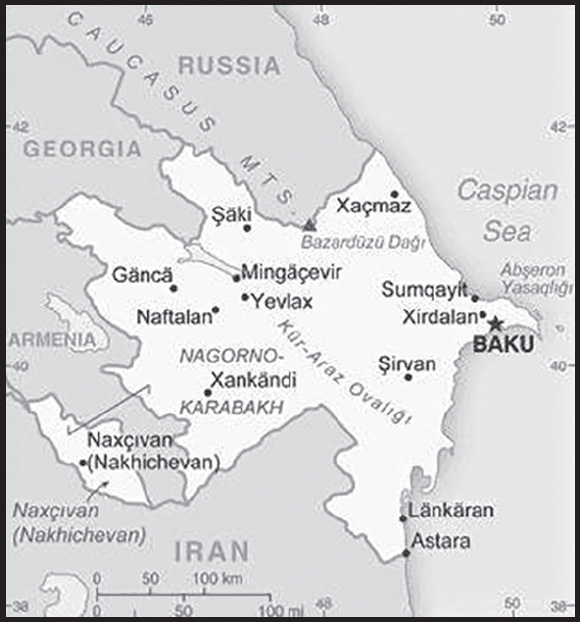
INTRODUCTION
Background: Azerbaijan - a secular nation with a majority-Turkic and majority-Shia Muslim population - was briefly independent (from 1918 to 1920) following the collapse of the Russian Empire; it was subsequently incorporated into the Soviet Union for seven decades. Since 1991, Azerbaijan has had a protracted conflict with Armenia over the Nagorno-Karabakh region, populated largely by ethnic Armenians but incorporated into Soviet Azerbaijan as an autonomous oblast in the early 1920s. In the late Soviet period, an ethnic-Armenian separatist movement developed that sought to end Azerbaijani control over the region. Fighting over Nagorno-Karabakh began in 1988 and escalated after Armenia and Azerbaijan attained independence from the Soviet Union in 1991. By the time a ceasefire took effect in May 1994, separatists, with Armenian support, controlled Nagorno-Karabakh and seven surrounding Azerbaijani territories.
Efforts to negotiate a peace agreement between Azerbaijan and Armenia began in the mid-1990s under the aegis of the Organization for Security and Cooperation in Europe’s Minsk Group, which was co-chaired by France, Russia, and the United States. At the same time, cease-fire violations and sporadic flare-ups continued. In September 2020, a second sustained conflict began when Azerbaijan took action to try to regain the territories it had lost in the 1990s. After six weeks of fighting that saw significant Azerbaijani gains, Russia brokered a cease-fire. Armenia returned to Azerbaijan the seven territories surrounding Nagorno-Karabakh that it had previously occupied and also the southern part of Nagorno-Karabakh. Despite Azerbaijan’s territorial gains, peace in the region remains elusive because of unsettled issues concerning the delimitation of borders, the opening of regional transportation and communication links, the status of ethnic enclaves near border regions, and the final status of the Nagorno-Karabakh region. Russian peacekeepers deployed to Nagorno-Karabakh to supervise the cease-fire for a minimum five-year term have not prevented the outbreak of sporadic, low-level military clashes along the Azerbaijan-Armenia border and in Nagorno-Karabakh.
In the three decades since its independence in 1991, Azerbaijan has significantly reduced the poverty rate and has directed some revenue from its oil and gas production to develop the country’s infrastructure. However, corruption remains a burden on the economy, and Western observers and members of the country’s political opposition have accused the government of authoritarianism, pointing to elections that are neither free nor fair, state control of the media, and the systematic abuse of human rights targeting individuals and groups who are perceived as threats to the administration. The country’s leadership has remained in the ALIYEV family since Heydar ALIYEV, formerly the most highly ranked Azerbaijani member of the Communist Party during the Soviet period, became president in the midst of the first Nagorno-Karabakh War in 1993. Heydar ALIYEV groomed his son to succeed him, and Ilham ALIYEV subsequently became president in 2003. As a result of two national referendums that eliminated presidential term limits and extended the presidential term from 5 to 7 years, President ALIYEV secured a fourth term in April 2018 in an election that international observers noted had serious shortcomings. Reforms are underway to diversify the country’s economy away from its dependence on oil and gas; additional reforms are needed to address weaknesses in government institutions, particularly in the education and health sectors, and the court system.
GEOGRAPHY
Location: Southwestern Asia, bordering the Caspian Sea, between Iran and Russia, with a small European portion north of the Caucasus range
Geographic coordinates: 40 30 N, 47 30 E
Map references: Asia
Area: total: 86,600 sq km
land: 82,629 sq km
water: 3,971 sq km
note: includes the exclave of Naxcivan Autonomous Republic and the Nagorno-Karabakh region; the final status of the region has yet to be determined
comparison ranking: total 113
Area - comparative: about three-quarters the size of Pennsylvania; slightly smaller than Maine
Land boundaries: total: 2,468 km
border countries (5): Armenia 996 km; Georgia 428 km; Iran 689 km; Russia 338 km; Turkey 17 km
Coastline: 0 km (landlocked); note - Azerbaijan borders the Caspian Sea (713 km)
Maritime claims: none (landlocked)
Climate: dry, semiarid steppe
Terrain: large, flat Kur-Araz Ovaligi (Kura-Araks Lowland, much of it below sea level) with Great Caucasus Mountains to the north, Qarabag Yaylasi (Karabakh Upland) to the west; Baku lies on Abseron Yasaqligi (Apsheron Peninsula) that juts into Caspian Sea
Elevation: highest point: Bazarduzu Dagi 4,466 m
lowest point: Caspian Sea -28 m
mean elevation: 384 m
Natural resources: petroleum, natural gas, iron ore, nonferrous metals, bauxite
Land use: agricultural land: 57.6% (2018 est.)
arable land: 22.8% (2018 est.)
permanent crops: 2.7% (2018 est.)
permanent pasture: 32.1% (2018 est.)
forest: 11.3% (2018 est.)
other: 31.1% (2018 est.)
Irrigated land: 14,649 sq km (2020)
Major lakes (area sq km): salt water lake(s): Caspian Sea (shared with Iran, Russia, Turkmenistan, and Kazakhstan) - 374,000 sq km
Population distribution: highest population density is found in the far eastern area of the country, in and around Baku; apart from smaller urbanized areas, the rest of the country has a fairly light and evenly distributed population
Natural hazards: droughts
Geography - note: both the main area of the country and the Naxcivan exclave are landlocked
PEOPLE AND SOCIETY
Population: 10,420,515 (2023 est.)
comparison ranking: 90
Nationality: noun: Azerbaijani(s)
adjective: Azerbaijani
Ethnic groups: Azerbaijani 91.6%, Lezghin 2%, Russian 1.3%, Armenian 1.3%, Talysh 1.3%, other 2.4% (2009 est.)
note: the Nagorno-Karabakh region, which is part of Azerbaijan on the basis of the borders recognized when the Soviet Union dissolved in 1991, is populated almost entirely by ethnic Armenians; Azerbaijan has over 80 ethnic groups
Languages: Azerbaijani (Azeri) (official) 92.5%, Russian 1.4%, Armenian 1.4%, other 4.7% (2009 est.)
major-language sample(s): Dünya fakt kitabı,  sas mlumatlar üçün vz olunmaz mnbdir (Azerbaijani)
note: Russian is widely spoken
Religions: Muslim 97.3% (predominantly Shia), Christian 2.6%, other <0.1, unaffiliated <0.1 (2020 est.)
note: religious affiliation for the majority of Azerbaijanis is largely nominal, percentages for actual practicing adherents are probably much lower
Demographic profile: Azerbaijan’s citizenry has over 80 ethnic groups. The far eastern part of the country has the highest population density, particularly in and around Baku. Apart from smaller urbanized areas, the rest of the country has a fairly light and evenly distributed population. Approximately 57% of the country’s inhabitants lives in urban areas. While the population is continuing to grow, it is in the early stages of aging. The declining fertility rate – which has decreased from about 5.5 children per woman in the 1950s to less than the 2.1 replacement level in 2022 – combined with increasing life expectancy has resulted in the elderly making up a larger share of Azerbaijan’s populace. The percentage of elderly residents and the slowed growth and eventual shrinkage of the working-age population could put pressure on the country’s pension and healthcare systems.
Age structure: 0-14 years: 21.78% (male 1,192,608/female 1,077,302)
15-64 years: 69.64% (male 3,619,341/female 3,637,494)
65 years and over: 8.58% (2023 est.) (male 356,184/female 537,586)
Dependency ratios: total dependency ratio: 44.2
youth dependency ratio: 34.7
elderly dependency ratio: 9.7
potential support ratio: 10.3 (2021 est.)
Median age: total: 32.6 years (2020)
male: 31.1 years
female: 34.2 years
comparison ranking: total 108
Population growth rate: 0.63% (2023 est.)
comparison ranking: 136
Birth rate: 13.2 births/1,000 population (2023 est.)
comparison ranking: 136
Death rate: 6.92 deaths/1,000 population (2023 est.)
comparison ranking: 120
Net migration rate: 0 migrant(s)/1,000 population (2023 est.)
comparison ranking: 93
Population distribution: highest population density is found in the far eastern area of the country, in and around Baku; apart from smaller urbanized areas, the rest of the country has a fairly light and evenly distributed population
Urbanization: urban population: 57.6% of total population (2023)
rate of urbanization: 1.38% annual rate of change (2020-25 est.)
note: data include Nagorno-Karabakh
Major urban areas - population: 2.432 million BAKU (capital) (2023)
Sex ratio: at birth: 1.06 male(s)/female
0-14 years: 1.11 male(s)/female
15-64 years: 1 male(s)/female
65 years and over: 0.66 male(s)/female
total population: 0.98 male(s)/female (2023 est.)
Mother’s mean age at first birth: 24 years (2019 est.)
Maternal mortality ratio: 41 deaths/100,000 live births (2020 est.)
comparison ranking: 102
Infant mortality rate: total: 22.93 deaths/1,000 live births (2023 est.)
male: 24.02 deaths/1,000 live births
female: 21.77 deaths/1,000 live births
comparison ranking: total 70
Life expectancy at birth: total population: 74.42 years (2023 est.)
male: 71.36 years
female: 77.66 years
comparison ranking: total population 142
Total fertility rate: 1.86 children born/woman (2023 est.)
comparison ranking: 133
Gross reproduction rate: 0.9 (2023 est.)
Drinking water source: improved: urban: 100% of population
rural: 93.3% of population
total: 97.1% of population
unimproved: urban: 0% of population
rural: 6.7% of population
total: 2.9% of population (2020 est.)
Current health expenditure: 4.6% of GDP (2020)
Physicians density: 3.17 physicians/1,000 population (2019)
Hospital bed density: 4.8 beds/1,000 population (2014)
Sanitation facility access: improved: urban: 100% of population
unimproved: urban: 0% of population
Obesity - adult prevalence rate: 19.9% (2016)
comparison ranking: 107
Alcohol consumption per capita: total: 1.38 liters of pure alcohol (2019 est.)
beer: 0.36 liters of pure alcohol (2019 est.)
wine: 0.06 liters of pure alcohol (2019 est.)
spirits: 0.94 liters of pure alcohol (2019 est.)
other alcohols: 0.01 liters of pure alcohol (2019 est.)
comparison ranking: total 143
Tobacco use: total: 24% (2020 est.)
male: 47.9% (2020 est.)
female: 0.1% (2020 est.)
comparison ranking: total 58
Children under the age of 5 years underweight: 4.9% (2013)
comparison ranking: 75
Currently married women (ages 15-49): 62.9% (2023 est.)
Education expenditures: 4.3% of GDP (2020 est.)
comparison ranking: 108
Literacy: definition: age 15 and over can read and write
total population: 99.8%
male: 99.9%
female: 99.7% (2019)
School life expectancy (primary to tertiary education): total: 14 years
male: 13 years
female: 14 years (2021)
Youth unemployment rate (ages 15-24): total: 16.5% (2021 est.)
male: 14.4%
female: 18.9%
comparison ranking: total 105
ENVIRONMENT
Environment - current issues: local scientists consider the Abseron Yasaqligi (Apsheron Peninsula) (including Baku and Sumqayit) and the Caspian Sea to be the ecologically most devastated area in the world because of severe air, soil, and water pollution; soil pollution results from oil spills, from the use of DDT pesticide, and from toxic defoliants used in the production of cotton; surface and underground water are polluted by untreated municipal and industrial wastewater and agricultural run-off
Environment - international agreements: party to: Air Pollution, Biodiversity, Climate Change, Climate Change-Kyoto Protocol, Climate Change-Paris Agreement, Comprehensive Nuclear Test Ban, Desertification, Endangered Species, Hazardous Wastes, Law of the Sea, Marine Dumping-London Convention, Ozone Layer Protection, Ship Pollution, Wetlands
signed, but not ratified: none of the selected agreements
Climate: dry, semiarid steppe
Land use: agricultural land: 57.6% (2018 est.)
arable land: 22.8% (2018 est.)
permanent crops: 2.7% (2018 est.)
permanent pasture: 32.1% (2018 est.)
forest: 11.3% (2018 est.)
other: 31.1% (2018 est.)
Urbanization: urban population: 57.6% of total population (2023)
rate of urbanization: 1.38% annual rate of change (2020-25 est.)
note: data include Nagorno-Karabakh
Revenue from forest resources: 0.02% of GDP (2018 est.)
comparison ranking: 139
Revenue from coal: 0% of GDP (2018 est.)
comparison ranking: 123
Air pollutants: particulate matter emissions: 24.64 micrograms per cubic meter (2019 est.)
carbon dioxide emissions: 37.62 megatons (2016 est.)
methane emissions: 44.87 megatons (2020 est.)
Waste and recycling: municipal solid waste generated annually: 2,930,349 tons (2015 est.)
Major lakes (area sq km): salt water lake(s): Caspian Sea (shared with Iran, Russia, Turkmenistan, and Kazakhstan) - 374,000 sq km
Total water withdrawal: municipal: 400 million cubic meters (2020 est.)
industrial: 570 million cubic meters (2020 est.)
agricultural: 11.6 billion cubic meters (2020 est.)
Total renewable water resources: 34.68 billion cubic meters (2020 est.)
GOVERNMENT
Country name: conventional long form: Republic of Azerbaijan
conventional short form: Azerbaijan
local long form: Azarbaycan Respublikasi
local short form: Azarbaycan
former: Azerbaijan Soviet Socialist Republic
etymology: the name translates as “Land of Fire” and refers to naturally occurring surface fires on ancient oil pools or from natural gas discharges
Government type: presidential republic
Capital: name: Baku (Baki, Baky)
geographic coordinates: 40 23 N, 49 52 E
time difference: UTC+4 (9 hours ahead of Washington, DC, during Standard Time)
daylight saving time: does not observe daylight savings time
etymology: the name derives from the Persian designation of the city “bad-kube” meaning “wind-pounded city” and refers to the harsh winds and severe snow storms that can hit the city
note: at approximately 28 m below sea level, Baku’s elevation makes it the lowest capital city in the world
Administrative divisions: 66 districts (rayonlar; rayon - singular), 11 cities (saharlar; sahar - singular);
rayons: Abseron, Agcabadi, Agdam, Agdas, Agstafa, Agsu, Astara, Babak, Balakan, Barda, Beylaqan, Bilasuvar, Cabrayil, Calilabad, Culfa, Daskasan, Fuzuli, Gadabay, Goranboy, Goycay, Goygol, Haciqabul, Imisli, Ismayilli, Kalbacar, Kangarli, Kurdamir, Lacin, Lankaran, Lerik, Masalli, Neftcala, Oguz, Ordubad, Qabala, Qax, Qazax, Qobustan, Quba, Qubadli, Qusar, Saatli, Sabirabad, Sabran, Sadarak, Sahbuz, Saki, Salyan, Samaxi, Samkir, Samux, Sarur, Siyazan, Susa, Tartar, Tovuz, Ucar, Xacmaz, Xizi, Xocali, Xocavand, Yardimli, Yevlax, Zangilan, Zaqatala, Zardab
cities: Baku, Ganca, Lankaran, Mingacevir, Naftalan, Naxcivan (Nakhichevan), Saki, Sirvan, Sumqayit, Xankandi, Yevlax
Independence: 30 August 1991 (declared from the Soviet Union); 18 October 1991 (adopted by the Supreme Council of Azerbaijan)
National holiday: Republic Day (founding of the Democratic Republic of Azerbaijan), 28 May (1918)
Constitution: history: several previous; latest adopted 12 November 1995
amendments: proposed by the president of the republic or by at least 63 members of the National Assembly; passage requires at least 95 votes of Assembly members in two separate readings of the draft amendment six months apart and requires presidential approval after each of the two Assembly votes, followed by presidential signature; constitutional articles on the authority, sovereignty, and unity of the people cannot be amended; amended 2002, 2009, 2016
Legal system: civil law system
International law organization participation: has not submitted an ICJ jurisdiction declaration; non-party state to the ICCt
Citizenship: citizenship by birth: yes
citizenship by descent only: yes
dual citizenship recognized: no
residency requirement for naturalization: 5 years
Suffrage: 18 years of age; universal
Executive branch: chief of state: President Ilham ALIYEV (since 31 October 2003); First Vice President Mehriban ALIYEVA (since 21 February 2017)
head of government: Prime Minister Ali ASADOV (since 8 October 2019); First Deputy Prime Minister Yaqub EYYUBOV (since 13 February 2003)
cabinet: Council of Ministers appointed by the president and confirmed by the National Assembly
elections/appointments: president directly elected by absolute majority popular vote in 2 rounds (if needed) for a 7-year term; a single individual is eligible for unlimited terms; election last held on 11 April 2018 (next to be held in 2025); prime minister and first deputy prime minister appointed by the president and confirmed by the National Assembly; note - a constitutional amendment approved in a September 2016 referendum extended the presidential term from 5 to 7 years; a separate constitutional amendment approved in the same referendum also introduced the post of first vice-president and additional vice-presidents, who are directly appointed by the president; however, no additional vice-presidents have been appointed since the constitutional amendment was passed
election results: Ilham ALIYEV reelected president in first round; percent of vote - Ilham ALIYEV (YAP) 86%, Zahid ORUJ (independent) 3.1%, other 10.9%
note: OSCE observers noted shortcomings in the election, including a restrictive political environment, limits on fundamental freedoms, a lack of genuine competition, and ballot box stuffing
Legislative branch: description: unicameral National Assembly or Milli Mejlis (125 seats, current 116; members directly elected in single-seat constituencies by simple majority vote to serve 5-year terms)
elections: last held early on 9 February 2020 (next to be held in 2025)
election results: percent of vote by party - NA; seats by party - YAP 69, CSP 3, AVP 1, CUP 1, ADMP 1, PDR 1, Great Order 1, National Front Party 1, REAL 1, VP 1, Whole Azerbaijan Popular Front 1, party unknown 1, independent 41; composition as of August 2023 - men 94, women 22, percent of women 19%
Judicial branch: highest court(s): Supreme Court (consists of the chairman, vice chairman, and 23 judges in plenum sessions and organized into civil, economic affairs, criminal, and rights violations chambers); Constitutional Court (consists of 9 judges)
judge selection and term of office: Supreme Court judges nominated by the president and appointed by the Milli Majlis; judges appointed for 10 years; Constitutional Court chairman and deputy chairman appointed by the president; other court judges nominated by the president and appointed by the Milli Majlis to serve single 15-year terms
subordinate courts: Courts of Appeal (replaced the Economic Court in 2002); district and municipal courts
Political parties and leaders: Azerbaijan Democratic Enlightenment Party or ADMP [Elshan MASAYEV]
Civic Solidarity Party or VHP [Sabir RUSTAMKHANLI]
Civic Unity Party or VBP [Sabir HAJIYEV]
Great Order Party [Fazil MUSTAFA]
Islamic Party of Azerbaijan or AiP [Mavsum SAMADOV]
Musavat (Equity) Party [Arif HAJILI]
Popular Front Party [Ali KARIMLI]
Motherland Party or AVP [Fazail AGAMALI]
National Front Party [Razi NURULLAYEV]
National Revival Movement Party [Faraj GULIYEV]
Party for Democratic Reforms or DIP [Asim MOLLAZADE]
Republican Alternative Party or REAL [Ilgar MAMMADOV]
Social Democratic Party [Ayaz MUTALIBOV]
Social Prosperity Party [Asli KAZIMOVA]
Unity Party or VP [Tahir KARIMLI]
Whole Azerbaijan Popular Front Party [Gudrat HASANGULIYEV]
New Azerbaijan Party (Yeni Azrbaycan Partiyasi) or YAP [Ilham ALIYEV]
International organization participation: ADB, BSEC, CD, CE, CICA, CIS, EAPC, EBRD, ECO, FAO, GCTU, GUAM, IAEA, IBRD, ICAO, ICC (NGOs), ICRM, IDA, IDB, IFAD, IFC, IFRCS, ILO, IMF, IMO, Interpol, IOC, IOM, IPU, ISO, ITSO, ITU, ITUC (NGOs), MIGA, NAM, OAS (observer), OIC, OPCW, OSCE, PFP, UN, UNCTAD, UNESCO, UNHCR, UNIDO, UNWTO, UPU, WCO, WFTU (NGOs), WHO, WIPO, WMO, WTO (observer)
Diplomatic representation in the US: chief of mission: Ambassador Kahzar IBRAHIM (since 15 September 2021)
chancery: 2741 34th Street NW, Washington, DC 20008
telephone: [1] (202) 337-3500
FAX: [1] (202) 337-5911
email address and website: azerbaijan@azembassy.us
https://washington.mfa.gov.az/en
consulate(s) general: Los Angeles
Diplomatic representation from the US: chief of mission: Ambassador (vacant); Chargé d’Affaires Hugo GUEVARA (since 29 June 2022)
embassy: 111 Azadlig Avenue, AZ1007 Baku
mailing address: 7050 Baku Place, Washington, DC 20521-7050
telephone: [994] (12) 488-3300
FAX: [994] (12) 488-3330
email address and website: BakuACS@state.gov
Flag description: three equal horizontal bands of sky blue (top), red, and green; a vertical crescent moon and an eight-pointed star in white are centered in the red band; the blue band recalls Azerbaijan’s Turkic heritage, red stands for modernization and progress, and green refers to Islam; the crescent moon and star are a Turkic insignia; the eight star points represent the eight Turkic peoples of the world
National symbol(s): flames of fire; national colors: blue, red, green
National anthem: name: “Azerbaijan Marsi” (March of Azerbaijan)
lyrics/music: Ahmed JAVAD/Uzeyir HAJIBEYOV
note: adopted 1992; although originally written in 1919 during a brief period of independence, “Azerbaijan Marsi” did not become the official anthem until after the dissolution of the Soviet Union
National heritage: total World Heritage Sites: 4 (all cultural)
selected World Heritage Site locales: Walled City of Baku; Gobustan Rock Art Cultural Landscape; Historic Center of Sheki; Cultural Landscape of Khinalig People and “Koc Yolu” Transhumance Route
ECONOMY
Economic overview: oil-based economy; macroeconomic instabilities due to demand shocks; recent state bailout of largest lender; potential economic gains from Nagorno-Karabakh conflict; negatively impacted by COVID-19; investing in human capital to diversify and retain younger generation
Real GDP (purchasing power parity): $146.305 billion (2021 est.)
$138.546 billion (2020 est.)
$144.771 billion (2019 est.)
note: data are in 2017 dollars
comparison ranking: 80
Real GDP growth rate: 5.6% (2021 est.)
-4.3% (2020 est.)
2.5% (2019 est.)
comparison ranking: 80
Real GDP per capita: $14,400 (2021 est.)
$13,700 (2020 est.)
$14,400 (2019 est.)
note: data are in 2017 dollars
comparison ranking: 114
GDP (official exchange rate): $48.104 billion (2019 est.)
Inflation rate (consumer prices): 6.65% (2021 est.)
2.76% (2020 est.)
2.61% (2019 est.)
comparison ranking: 49
Credit ratings: Fitch rating: BB+ (2016)
Moody’s rating: Ba2 (2017)
Standard & Poors rating: BB+ (2016)
note: The year refers to the year in which the current credit rating was first obtained.
GDP - composition, by sector of origin: agriculture: 6.1% (2017 est.)
industry: 53.5% (2017 est.)
services: 40.4% (2017 est.)
comparison rankings: services 211; industry 7; agriculture 119
GDP - composition, by end use: household consumption: 57.6% (2017 est.)
government consumption: 11.5% (2017 est.)
investment in fixed capital: 23.6% (2017 est.)
investment in inventories: 0.5% (2017 est.)
exports of goods and services: 48.7% (2017 est.)
imports of goods and services: -42% (2017 est.)
Agricultural products: milk, wheat, potatoes, barley, tomatoes, watermelons, cotton, apples, maize, onions
Industries: petroleum and petroleum products, natural gas, oilfield equipment; steel, iron ore; cement; chemicals and petrochemicals; textiles
Industrial production growth rate: 1.95% (2021 est.)
comparison ranking: 135
Labor force: 4.919 million (2021 est.)
comparison ranking: 87
Labor force - by occupation: agriculture: 37%
industry: 14.3%
services: 48.9% (2014)
Unemployment rate: 6.58% (2021 est.)
6.46% (2020 est.)
4.85% (2019 est.)
comparison ranking: 119
Youth unemployment rate (ages 15-24): total: 16.5% (2021 est.)
male: 14.4%
female: 18.9%
comparison ranking: total 105
Population below poverty line: 4.9% (2015 est.)
Gini Index coefficient - distribution of family income: 33.7 (2008)
comparison ranking: 118
Average household expenditures: on food: 38.6% of household expenditures (2018 est.)
on alcohol and tobacco: 1.6% of household expenditures (2018 est.)
Household income or consumption by percentage share: lowest 10%: 3.4%
highest 10%: 27.4% (2008)
Budget: revenues: $19.95 billion (2019 est.)
expenditures: $16.001 billion (2019 est.)
Budget surplus (+) or deficit (-): -1.6% (of GDP) (2017 est.)
comparison ranking: 93
Public debt: 54.1% of GDP (2017 est.)
50.7% of GDP (2016 est.)
comparison ranking: 92
Taxes and other revenues: 14.22% (of GDP) (2019 est.)
comparison ranking: 157
Fiscal year: calendar year
Current account balance: $8.292 billion (2021 est.)
-$227.568 million (2020 est.)
$4.365 billion (2019 est.)
comparison ranking: 29
Exports: $25.488 billion (2021 est.)
$15.209 billion (2020 est.)
$23.63 billion (2019 est.)
note: Data are in current year dollars and do not include illicit exports or re-exports.
comparison ranking: 78
Exports - partners: Italy 28%, Turkey 15%, Israel 7%, Germany 5%, India 5% (2017)
Exports - commodities: crude petroleum, natural gas, refined petroleum, cotton, gold (2021)
Imports: $16.337 billion (2021 est.) note: data are in current year dollars
$15.538 billion (2020 est.) note: data are in current year dollars
$17.712 billion (2019 est.) note: data are in current year dollars
comparison ranking: 97
Imports - partners: United Kingdom 17%, Russia 17%, Turkey 12%, China 6% (2019)
Imports - commodities: gold, cars, refined petroleum, wheat, packaged medical supplies (2019)
Reserves of foreign exchange and gold: $8.307 billion (31 December 2021 est.)
$7.634 billion (31 December 2020 est.)
$7.043 billion (31 December 2019 est.)
comparison ranking: 90
Debt - external: $17.41 billion (31 December 2017 est.)
$13.83 billion (31 December 2016 est.)
comparison ranking: 99
Exchange rates: Azerbaijani manats (AZN) per US dollar -
Exchange rates: 1.7 (2021 est.)
1.7 (2020 est.)
1.7 (2019 est.)
1.7 (2018 est.)
1.721 (2017 est.)
ENERGY
Electricity access: electrification - total population: 100% (2021)
Electricity: installed generating capacity: 7.677 million kW (2020 est.)
consumption: 21.027 billion kWh (2019 est.)
exports: 1.491 billion kWh (2020 est.)
imports: 137 million kWh (2020 est.)
transmission/distribution losses: 2.226 billion kWh (2019 est.)
comparison rankings: imports 105; exports 55; installed generating capacity 74; transmission/distribution losses 84; consumption 71
Electricity generation sources: fossil fuels: 94.2% of total installed capacity (2020 est.)
nuclear: 0% of total installed capacity (2020 est.)
solar: 0.2% of total installed capacity (2020 est.)
wind: 0.4% of total installed capacity (2020 est.)
hydroelectricity: 4.4% of total installed capacity (2020 est.)
tide and wave: 0% of total installed capacity (2020 est.)
geothermal: 0% of total installed capacity (2020 est.)
biomass and waste: 0.8% of total installed capacity (2020 est.)
Coal: production: 0 metric tons (2020 est.)
consumption: 19,000 metric tons (2020 est.)
exports: 0 metric tons (2020 est.)
imports: 19,000 metric tons (2020 est.)
proven reserves: 0 metric tons (2019 est.)
Petroleum: total petroleum production: 711,700 bbl/day (2021 est.)
refined petroleum consumption: 107,500 bbl/day (2019 est.)
crude oil and lease condensate exports: 679,900 bbl/day (2018 est.)
crude oil and lease condensate imports: 0 bbl/day (2018 est.)
crude oil estimated reserves: 7 billion barrels (2021 est.)
Refined petroleum products - production: 138,900 bbl/day (2015 est.)
comparison ranking: 61
Refined petroleum products - exports: 46,480 bbl/day (2015 est.)
comparison ranking: 57
Refined petroleum products - imports: 5,576 bbl/day (2015 est.)
comparison ranking: 168
Natural gas: production: 23.075 billion cubic meters (2019 est.)
consumption: 11.468 billion cubic meters (2019 est.)
exports: 11.586 billion cubic meters (2019 est.)
imports: 1.233 billion cubic meters (2019 est.)
proven reserves: 1.699 trillion cubic meters (2021 est.)
Carbon dioxide emissions: 35.389 million metric tonnes of CO2 (2019 est.)
from coal and metallurgical coke: 29,000 metric tonnes of CO2 (2019 est.)
from petroleum and other liquids: 12.863 million metric tonnes of CO2 (2019 est.)
from consumed natural gas: 22.497 million metric tonnes of CO2 (2019 est.)
comparison ranking: total emissions 72
Energy consumption per capita: 64.416 million Btu/person (2019 est.)
comparison ranking: 86
COMMUNICATIONS
Telephones - fixed lines: total subscriptions: 1,644,300 (2021 est.)
subscriptions per 100 inhabitants: 16 (2021 est.)
comparison ranking: total subscriptions 58
Telephones - mobile cellular: total subscriptions: 10,817,071 (2021 est.)
subscriptions per 100 inhabitants: 105 (2021 est.)
comparison ranking: total subscriptions 91
Telecommunication systems: general assessment: in spite of the telecom sector being one of the major contributors to Azerbaijan’s non-oil GDP, overall development, growth, and investment in the sector has been held back by years of political and civil unrest coupled with endemic corruption; mobile penetration rates reached 100% as far back as 2011 but have largely stagnated since then; the Mobile Network Operators (MNOs) are slowly extending the reach of their LTE networks around the country, and this increased coverage (along with access to faster data-based services) is expected to produce a moderate resurgence for both mobile and mobile broadband over the next few years as customers migrate from 3G to 4G. 5G services are still some ways off, as the demand for high-speed data and fast broadband can easily be met by existing capacity on LTE networks; fixed-line teledensity continues to drop down each year as customers consolidate their telecommunications services around the mobile platform; the rate of decline is comparatively slower than other countries, since Azerbaijan has a relatively high proportion of (87%) of fixed-line broadband customers still on DSL; fiber is gradually being rolled out in urban areas, and this makes up the bulk of the growth being seen in the overall fixed broadband market; DSL’s predominance, however, will serve to keep Azerbaijan’s average access speeds in the sub-10Mbps range for the foreseeable future (2020)
domestic: 16 fixed-lines subscriptions per 100 persons; mobile-cellular subscriptions of 105 telephones per 100 persons (2021)
international: country code - 994; Azerbaijan’s largest mobile network operator (MNO) launched trial 5G mobile services in Baku on 27 December 2022 (2023)
Broadcast media: 3 state-run and 1 public TV channels; 4 domestic commercial TV stations and about 15 regional TV stations; cable TV services are available in Baku; 1 state-run and 1 public radio network operating; a small number of private commercial radio stations broadcasting; local FM relays of Baku commercial stations are available in many localities; note - all broadcast media is pro-government, and most private broadcast media outlets are owned by entities directly linked to the government
Internet country code: .az
Internet users: total: 8.6 million (2021 est.)
percent of population: 86% (2021 est.)
comparison ranking: total 67
Broadband - fixed subscriptions: total: 1,995,474 (2020 est.)
subscriptions per 100 inhabitants: 20 (2020 est.)
comparison ranking: total 58
TRANSPORTATION
National air transport system: number of registered air carriers: 42 (2020)
inventory of registered aircraft operated by air carriers: 44
annual passenger traffic on registered air carriers: 2,279,546 (2018)
annual freight traffic on registered air carriers: 44.09 million (2018) mt-km
Civil aircraft registration country code prefix: 4K
Airports: 23 (2021)
comparison ranking: total 132
Airports - with paved runways: 30
civil airports: 4
military airports: 5
joint use (civil-military) airports: 1
other airports: 20
note: paved runways have a concrete or asphalt surface but not all have facilities for refueling, maintenance, or air traffic control; the length of a runway required for aircraft to safely operate depends on a number of factors including the type of aircraft, the takeoff weight (including passengers, cargo, and fuel), engine types, flap settings, landing speed, elevation of the airport, and average maximum daily air temperature; paved runways can reach a length of 5,000 m (16,000 ft.), but the “typical” length of a commercial airline runway is between 2,500-4,000 m (8,000-13,000 ft.)
Airports - with unpaved runways: 7
note: unpaved runways have a surface composition such as grass or packed earth and are most suited to the operation of light aircraft; unpaved runways are usually short, often less than 1,000 m (3,280 ft.) in length; airports with unpaved runways often lack facilities for refueling, maintenance, or air traffic control
Heliports: 1 (2021)
Pipelines: 89 km condensate, 3,890 km gas, 2,446 km oil (2013)
Railways: total: 2,944.3 km (2017)
broad gauge: 2,944.3 km (2017) 1.520-m gauge (approx. 1,767 km electrified)
comparison ranking: total 59
Roadways: total: 24,981 km (2013)
paved: (2013)
unpaved: (2013)
note: total roadway length has increased significantly and continues to grow due to the recovery of Armenian-held territories and related reconstruction efforts. No updated figure is currently available.
comparison ranking: total 104
Merchant marine: total: 309 (2022)
by type: general cargo 38, oil tanker 44, other 227
comparison ranking: total 54
Ports and terminals: major seaport(s): Baku (Baki) located on the Caspian Sea
MILITARY AND SECURITY
Military and security forces: Azerbaijan Armed Forces: Land Forces, Air Forces, Navy Forces, State Border Service, Coast Guard
Ministry of Internal Affairs: Internal Troops, local police forces; Special State Protection Service (SSPS): National Guard (2023)
note: the Ministry of Internal Affairs and the State Security Service (intelligence, counterterrorism) are responsible for internal security; the SSPS is under the president and provides protective services to senior officials, foreign missions, significant state assets, government buildings, etc; the National Guard also serves as a reserve for the Army
Military expenditures: 4.5% of GDP (2022 est.)
5% of GDP (2021 est.)
5% of GDP (2020 est.)
3.8% of GDP (2019 est.)
3.6% of GDP (2018 est.)
comparison ranking: 11
Military and security service personnel strengths: estimates vary; approximately 60-75,000 active armed forces; approximately 15,000 Ministry of Internal Affairs troops (2023)
Military equipment inventories and acquisitions: Baku has been actively upgrading its equipment for over a decade with purchases from Belarus, Israel, Russia, and Turkey; while most of the military’s equipment was once Soviet-era material, it now fields quantities of advanced equipment, including armored vehicles, artillery systems, air defense systems, tanks, and UAVs (2023)
Military service age and obligation: 18-25 years of age for compulsory military service for men; 17-35 years of age for voluntary service for men and women; 18 months service for conscripts (2023)
note: most of the military is made up of professional contract soldiers; as of 2018, women made up an estimated 3% of the active duty military
Military - note: the Azerbaijani military was established in 1991, although its origins go back to 1918; much of the military’s original equipment was acquired from former Soviet military forces that left Azerbaijan by 1992; territorial defense is the military’s primary focus, particularly with regards to neighboring Armenia; a secondary focus is guarding against Iran; the Ground Forces have five army corps, plus an independent combined arms army, which is assigned to the Azerbaijani exclave of Naxicvan (Nakhichevan); between them, the corps and the combined arms army have more than 20 mechanized or motorized combat brigades; the Ground Forces also have separate brigades of artillery, battlefield rockets, and special forces; the Air Force has about 30 Russian-origin fighters and ground attack aircraft, as well as some combat helicopters; the Navy patrols the Caspian Sea with a corvette and several coastal patrol craft
Armenia and Azerbaijan engaged in open conflicts over the Nagorno-Karabakh enclave in 1991-94 and 2020, plus a brief flare-up in 2016; tensions continued following the 2020 conflict; Azerbaijan seized the entire enclave in 2023
Turkey is Azerbaijan’s strongest military partner, a relationship that has included weapons transfers, technical advice, bilateral training exercises, and key support during the 2020 conflict with Armenia; military reforms over the past decade and the operations of the Azerbaijani forces during the 2020 conflict reflected Turkish influence; Azerbaijan is not part of NATO but has had a cooperative relationship with it dating back to when it joined NATO’s Partnership for Peace program in 1994 and has provided troops to NATO-led missions in Kosovo (1999-2008) and Afghanistan (2002-2014) (2023)
SPACE
Space agency/agencies: Azerbaijan National Aerospace Agency (NASA; Azrbaycan Milli Aerokosmik Agentliyi, MAKA; established in 1992 from the Kaspiy Scientific Center, established 1974); Space Agency of the Republic of Azerbaijan (Azercosmos; established 2010 as a state-owned satellite operating company) (2023)
Space program overview: national space program largely focused on the acquisition and operation of satellites; operates foreign-built communications and remote sensing (RS) satellites; has two satellite ground control stations; cooperates with a variety of foreign space agencies and commercial entities, including those of China, the European Space Agency (and individual member states such as France), Russia, and the US; Azercosmos is the largest satellite operator in the Caucasus region (2023)
note: further details about the key activities, programs, and milestones of the country’s space program, as well as government spending estimates on the space sector, appear in Appendix S
TERRORISM
Terrorist group(s): Terrorist group(s): Islamic State of Iraq and ash-Sham (ISIS); Islamic Revolutionary Guard Corps (IRGC)/Qods Force
note: details about the history, aims, leadership, organization, areas of operation, tactics, targets, weapons, size, and sources of support of the group(s) appear(s) in Appendix-T
TRANSNATIONAL ISSUES
Disputes - international: Armenia-Azerbaijan: tensions existed for years over the break-away Nagorno-Karabakh region and the Armenian military occupation of surrounding lands in Azerbaijan; Azerbaijan seized part of the enclave during six weeks of fighting in 2020 and the remainder in a short conflict in September 2023; in October 2023, Baku and Yerevan began preliminary discussions on a peace treaty, the demarcation of borders, and full normalization of relations; nevertheless, concerns persist in Armenia that Azerbaijan could invade in order to force the establishment of a transit corridor to the exclave of Naxicvan (Nakhichevan)
Azerbaijan-Georgia: a joint boundary commission agrees on most of the alignment, leaving only small areas at certain crossing points in dispute; consequently, the two states have yet to agree on a delimitation or demarcation of their common boundary; one area of contention is where the international boundary should run through the 6th-13th Century David-Gareja monastery complex
Azerbaijan-Iran: in recent years, tensions between Azerbajian and Iran have risen in part because of warming ties between Azerbaijan and Israel, and Baku’s claims that Tehran has backed Armenia over the disputed Nagorno-Karabakh enclave
Azerbaijan-Russia: Russia has complained of cross-border smuggling
Azerbaijan-Turkey: none identified; as of 2023, Turkey and Armenia were discussing normalizing relations
Caspian Sea (Maritime Boundary): Azerbaijan, Kazakhstan, and Russia ratified the Caspian seabed delimitation treaties based on equidistance, while Iran continues to insist on a one-fifth slice of the sea; bilateral talks continue with Turkmenistan on dividing the seabed and contested oilfields in the middle of the Caspian local border forces struggle to control the illegal transit of goods and people across the porous, undemarcated Armenian, Azerbaijani, and Georgian borders
Refugees and internally displaced persons: IDPs: 659,000 (conflict with Armenia over Nagorno-Karabakh; IDPs are mainly ethnic Azerbaijanis but also include ethnic Kurds, Russians, and Turks predominantly from occupied territories around Nagorno-Karabakh; includes IDPs’ descendants, returned IDPs, and people living in insecure areas and excludes people displaced by natural disasters; around half the IDPs live in the capital Baku) (2022)
stateless persons: 3,585 (2022)
Illicit drugs: limited illicit cultivation of cannabis and opium poppy, mostly for CIS consumption; small government eradication program; transit point for Southwest Asian opiates bound for Russia and to a lesser extent the rest of Europe