INTRODUCTION
Background: In the early 1800s, multiple political entities in what is now Botswana were destabilized or destroyed by a series of conflicts and population movements in southern Africa. By the end of this period, the Tswana ethnic group, who also live across the border in South Africa, had become the most prominent group in the area. In 1852, Tswana forces halted the expansion of white Afrikaner settlers who were seeking to expand their territory northwards into what is now Botswana. In 1885, Great Britain claimed territory that roughly corresponds with modern day Botswana as a protectorate called Bechuanaland. Upon independence in 1966, the British protectorate of Bechuanaland adopted the new name of Botswana, which means land of the Tswana. More than five decades of uninterrupted civilian leadership, progressive social policies, and significant capital investment have created an enduring democracy and upper-middle-income economy. The ruling Botswana Democratic Party has won every national election since independence; President Mokgweetsi Eric MASISI assumed the presidency in 2018 following the retirement of former President Ian KHAMA due to constitutional term limits. MASISI won his first election as president in 2019, and he is Botswana’s fifth president since independence. Mineral extraction, principally diamond mining, dominates economic activity, though tourism is a growing sector due to the country’s conservation practices and extensive nature preserves. Botswana has one of the world’s highest rates of HIV/AIDS infection but also one of Africa’s most progressive and comprehensive programs for dealing with the disease.
GEOGRAPHY
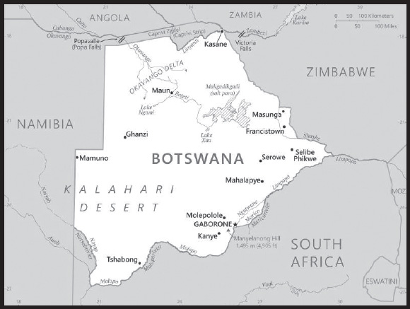
Location: Southern Africa, north of South Africa
Geographic coordinates: 22 00 S, 24 00 E
Map references: Africa
Area: total: 581,730 sq km
land: 566,730 sq km
water: 15,000 sq km
comparison ranking: total 50
Area - comparative: slightly smaller than Texas; almost four times the size of Illinois
Land boundaries: total: 4,347.15 km
border countries (4): Namibia 1,544 km; South Africa 1,969 km; Zambia 0.15 km; Zimbabwe 834 km
Coastline: 0 km (landlocked)
Maritime claims: none (landlocked)
Climate: semiarid; warm winters and hot summers
Terrain: predominantly flat to gently rolling tableland; Kalahari Desert in southwest
Elevation: highest point: Manyelanong Hill 1,495 m
lowest point: junction of the Limpopo and Shashe Rivers 513 m
mean elevation: 1,013 m
Natural resources: diamonds, copper, nickel, salt, soda ash, potash, coal, iron ore, silver
Land use: agricultural land: 45.8% (2018 est.)
arable land: 0.6% (2018 est.)
permanent crops: 0% (2018 est.)
permanent pasture: 45.2% (2018 est.)
forest: 19.8% (2018 est.)
other: 34.4% (2018 est.)
Irrigated land: 25 sq km (2014)
Major rivers (by length in km): Zambezi (shared with Zambia [s]), Angola, Namibia, Zimbabwe, and Mozambique [m]) - 2,740 km; Limpopo (shared with South Africa [s], Zimbabwe, and Mozambique [m]) - 1,800 km; Okavango river mouth (shared with Angola [s], and Namibia) - 1,600 km
note – [s] after country name indicates river source; [m] after country name indicates river mouth
Major watersheds (area sq km): Atlantic Ocean drainage: Orange (941,351 sq km)
Indian Ocean drainage: Zambezi (1,332,412 sq km)
Internal (endorheic basin) drainage: Okavango Basin (863,866 sq km)
Major aquifers: Lower Kalahari-Stampriet Basin, Upper Kalahari-Cuvelai-Upper Zambezi Basin
Population distribution: the population is primarily concentrated in the east with a focus in and around the captial of Gaborone, and the far central-eastern city of Francistown; population density remains low in other areas in the country, especially in the Kalahari to the west as shown in this population distribution map
Natural hazards: periodic droughts; seasonal August winds blow from the west, carrying sand and dust across the country, which can obscure visibility
Geography - note: landlocked; sparsely populated with most settlement concentrated in the southern and eastern parts of the country; geography dominated by the Kalahari Desert, which covers about 70% of the country, although the Okavango Delta brings considerable biodiversity as one of the largest inland deltas in the World
PEOPLE AND SOCIETY
Population: 2,417,596 (2023 est.)
comparison ranking: 145
Nationality: noun: Motswana (singular), Batswana (plural)
adjective: Motswana (singular), Batswana (plural)
Ethnic groups: Tswana (or Setswana) 79%, Kalanga 11%, Basarwa 3%, other, including Kgalagadi and people of European ancestry 7%
Languages: Setswana 77.3%, Sekalanga 7.4%, Shekgalagadi 3.4%, English (official) 2.8%, Zezuru/Shona 2%, Sesarwa 1.7%, Sembukushu 1.6%, Ndebele 1%, other 2.8% (2011 est.)
Religions: Christian 79.1%, Badimo 4.1%, other 1.4% (includes Baha’i, Hindu, Muslim, Rastafarian), none 15.2%, unspecified 0.3% (2011 est.)
Demographic profile: Botswana has experienced one of the most rapid declines in fertility in Sub-Saharan Africa. The total fertility rate fell from more than 5 children per woman in the mid 1980s to approximately 2.4 in 2013, and remains at that level in 2022. The fertility reduction has been attributed to a host of factors, including higher educational attainment among women, greater participation of women in the workforce, increased contraceptive use, later first births, and a strong national family planning program. Botswana was making significant progress in several health indicators, including life expectancy and infant and child mortality rates, until being devastated by the HIV/AIDs epidemic in the 1990s.
In 2021, Botswana had one of the highest HIV/AIDS prevalence rates in the world at close to 20%, however comprehensive and effective treatment programs have reduced HIV/AIDS-related deaths. The combination of declining fertility and increasing mortality rates because of HIV/AIDS is slowing the population aging process, with a narrowing of the youngest age groups and little expansion of the oldest age groups. Nevertheless, having the bulk of its population (about 60% as of 2022) of working age will only yield economic benefits if the labor force is healthy, educated, and productively employed.
Batswana have been working as contract miners in South Africa since the 19th century. Although Botswana’s economy improved shortly after independence in 1966 with the discovery of diamonds and other minerals, its lingering high poverty rate and lack of job opportunities continued to push workers to seek mining work in southern African countries. In the early 1970s, about a third of Botswana’s male labor force worked in South Africa (lesser numbers went to Namibia and Zimbabwe). Not until the 1980s and 1990s, when South African mining companies had reduced their recruitment of foreign workers and Botswana’s economic prospects had improved, were Batswana increasingly able to find job opportunities at home.
Most Batswana prefer life in their home country and choose cross-border migration on a temporary basis only for work, shopping, visiting family, or tourism. Since the 1970s, Botswana has pursued an open migration policy enabling it to recruit thousands of foreign workers to fill skilled labor shortages. In the late 1990s, Botswana’s prosperity and political stability attracted not only skilled workers but small numbers of refugees from neighboring Angola, Namibia, and Zimbabwe.
Age structure: 0-14 years: 29.17% (male 355,951/female 349,283)
15-64 years: 64.88% (male 745,327/female 823,267)
65 years and over: 5.95% (2023 est.) (male 57,876/female 85,892)
Dependency ratios: total dependency ratio: 57.5
youth dependency ratio: 51.8
elderly dependency ratio: 5.7
potential support ratio: 13.8 (2021 est.)
Median age: total: 25.7 years (2020)
male: 24.5 years
female: 26.7 years
comparison ranking: total 158
Population growth rate: 1.37% (2023 est.)
comparison ranking: 68
Birth rate: 19.95 births/1,000 population (2023 est.)
comparison ranking: 70
Death rate: 8.98 deaths/1,000 population (2023 est.)
comparison ranking: 62
Net migration rate: 2.77 migrant(s)/1,000 population (2023 est.)
comparison ranking: 40
Population distribution: the population is primarily concentrated in the east with a focus in and around the captial of Gaborone, and the far central-eastern city of Francistown; population density remains low in other areas in the country, especially in the Kalahari to the west as shown in this population distribution map
Urbanization: urban population: 72.9% of total population (2023)
rate of urbanization: 2.47% annual rate of change (2020-25 est.)
Major urban areas - population: 269,000 GABORONE (capital) (2018)
Sex ratio: at birth: 1.03 male(s)/female
0-14 years: 1.02 male(s)/female
15-64 years: 0.91 male(s)/female
65 years and over: 0.67 male(s)/female
total population: 0.92 male(s)/female (2023 est.)
Maternal mortality ratio: 186 deaths/100,000 live births (2020 est.)
comparison ranking: 48
Infant mortality rate: total: 24.41 deaths/1,000 live births (2023 est.)
male: 26.72 deaths/1,000 live births
female: 22.04 deaths/1,000 live births
comparison ranking: total 68
Life expectancy at birth: total population: 66.04 years (2023 est.)
male: 63.98 years
female: 68.16 years
comparison ranking: total population 200
Total fertility rate: 2.37 children born/woman (2023 est.)
comparison ranking: 74
Gross reproduction rate: 1.17 (2023 est.)
Contraceptive prevalence rate: 67.4% (2017)
Drinking water source: improved: urban: 98.1% of population
rural: 96.9% of population
total: 99.4% of population
unimproved: urban: 0.2% of population
rural: 3.1% of population
total: 0.6% of population (2020 est.)
Current health expenditure: 6.2% of GDP (2020)
Physicians density: 0.38 physicians/1,000 population (2018)
Hospital bed density: 1.8 beds/1,000 population
Sanitation facility access: improved: urban: 94.9% of population
rural: 63% of population
total: 85.6% of population
unimproved: urban: 5.1% of population
rural: 37% of population
total: 14.4% of population (2020 est.)
Major infectious diseases: degree of risk: high (2023)
food or waterborne diseases: bacterial diarrhea, hepatitis A, and typhoid fever
vectorborne diseases: malaria
note: on 31 August 2023, the US Centers for Disease Control and Prevention (CDC) issued a Travel Alert for polio in Africa; Botswana is currently considered a high risk to travelers for circulating vaccine-derived polioviruses (cVDPV); vaccine-derived poliovirus (VDPV) is a strain of the weakened poliovirus that was initially included in oral polio vaccine (OPV) and that has changed over time and behaves more like the wild or naturally occurring virus; this means it can be spread more easily to people who are unvaccinated against polio and who come in contact with the stool or respiratory secretions, such as from a sneeze, of an “infected” person who received oral polio vaccine; the CDC recommends that before any international travel, anyone unvaccinated, incompletely vaccinated, or with an unknown polio vaccination status should complete the routine polio vaccine series; before travel to any high-risk destination, the CDC recommends that adults who previously completed the full, routine polio vaccine series receive a single, lifetime booster dose of polio vaccine
Obesity - adult prevalence rate: 18.9% (2016)
comparison ranking: 114
Alcohol consumption per capita: total: 5.98 liters of pure alcohol (2019 est.)
beer: 2.93 liters of pure alcohol (2019 est.)
wine: 0.46 liters of pure alcohol (2019 est.)
spirits: 0.96 liters of pure alcohol (2019 est.)
other alcohols: 1.64 liters of pure alcohol (2019 est.)
comparison ranking: total 71
Tobacco use: total: 19.4% (2020 est.)
male: 30.4% (2020 est.)
female: 8.3% (2020 est.)
comparison ranking: total 90
Currently married women (ages 15-49): 45% (2023 est.)
Education expenditures: 8.7% of GDP (2020 est.)
comparison ranking: 10
Literacy: definition: age 15 and over can read and write
total population: 88.5%
male: 88%
female: 88.9% (2015)
School life expectancy (primary to tertiary education): total: 12 years
male: 12 years
female: 12 years (2021)
Youth unemployment rate (ages 15-24): total: 41.2% (2021 est.)
male: 39.5%
female: 43.3%
comparison ranking: total 9
ENVIRONMENT
Environment - current issues: overgrazing; desertification; limited freshwater resources; air pollution
Environment - international agreements: party to: Biodiversity, Climate Change, Climate Change-Kyoto Protocol, Climate Change-Paris Agreement, Desertification, Endangered Species, Hazardous Wastes, Law of the Sea, Nuclear Test Ban, Ozone Layer Protection, Wetlands
signed, but not ratified: none of the selected agreements
Climate: semiarid; warm winters and hot summers
Land use: agricultural land: 45.8% (2018 est.)
arable land: 0.6% (2018 est.)
permanent crops: 0% (2018 est.)
permanent pasture: 45.2% (2018 est.)
forest: 19.8% (2018 est.)
other: 34.4% (2018 est.)
Urbanization: urban population: 72.9% of total population (2023)
rate of urbanization: 2.47% annual rate of change (2020-25 est.)
Revenue from forest resources: 0.23% of GDP (2018 est.)
comparison ranking: 88
Revenue from coal: 0.45% of GDP (2018 est.)
comparison ranking: 13
Air pollutants: particulate matter emissions: 12.82 micrograms per cubic meter (2019 est.)
carbon dioxide emissions: 6.34 megatons (2016 est.)
methane emissions: 5.73 megatons (2020 est.)
Waste and recycling: municipal solid waste generated annually: 210,854 tons (2010 est.)
municipal solid waste recycled annually: 2,109 tons (2005 est.)
percent of municipal solid waste recycled: 1% (2005 est.)
Major rivers (by length in km): Zambezi (shared with Zambia [s]), Angola, Namibia, Zimbabwe, and Mozambique [m]) - 2,740 km; Limpopo (shared with South Africa [s], Zimbabwe, and Mozambique [m]) - 1,800 km; Okavango river mouth (shared with Angola [s], and Namibia) - 1,600 km
note – [s] after country name indicates river source; [m] after country name indicates river mouth
Major watersheds (area sq km): Atlantic Ocean drainage: Orange (941,351 sq km)
Indian Ocean drainage: Zambezi (1,332,412 sq km)
Internal (endorheic basin) drainage: Okavango Basin (863,866 sq km)
Major aquifers: Lower Kalahari-Stampriet Basin, Upper Kalahari-Cuvelai-Upper Zambezi Basin
Total water withdrawal: municipal: 110 million cubic meters (2020 est.)
industrial: 30 million cubic meters (2020 est.)
agricultural: 80 million cubic meters (2020 est.)
Total renewable water resources: 12.24 billion cubic meters (2020 est.)
GOVERNMENT
Country name: conventional long form: Republic of Botswana
conventional short form: Botswana
local long form: Republic of Botswana
local short form: Botswana
former: Bechuanaland
etymology: the name Botswana means “Land of the Tswana” - referring to the country’s largest ethnic group
Government type: parliamentary republic
Capital: name: Gaborone
geographic coordinates: 24 38 S, 25 54 E
time difference: UTC+2 (7 hours ahead of Washington, DC, during Standard Time)
etymology: named after GABORONE (ca. 1825-1931), a revered kgosi (chief) of the Tlokwa tribe, part of the larger Tswana ethnic group
Administrative divisions: 10 districts and 6 town councils*; Central, Chobe, Francistown*, Gaborone*, Ghanzi, Jwaneng*, Kgalagadi, Kgatleng, Kweneng, Lobatse*, North East, North West, Selebi-Phikwe*, South East, Southern, Sowa Town*
Independence: 30 September 1966 (from the UK)
National holiday: Independence Day (Botswana Day), 30 September (1966)
Constitution: history: previous 1960 (preindependence); latest adopted March 1965, effective 30 September 1966
amendments: proposed by the National Assembly; passage requires approval in two successive Assembly votes with at least two-thirds majority in the final vote; proposals to amend constitutional provisions on fundamental rights and freedoms, the structure and branches of government, and public services also requires approval by majority vote in a referendum and assent by the president of the republic; amended several times, last in 2021
Legal system: mixed legal system of civil law influenced by the Roman-Dutch model and also customary and common law
International law organization participation: accepts compulsory ICJ jurisdiction with reservations; accepts ICCt jurisdiction
Citizenship: citizenship by birth: no
citizenship by descent only: at least one parent must be a citizen of Botswana
dual citizenship recognized: no
residency requirement for naturalization: 10 years
Suffrage: 18 years of age; universal
Executive branch: chief of state: President Mokgweetse Eric MASISI (since 1 April 2018); Vice President Slumber TSOGWANE (since 4 April 2018); note - the president is both chief of state and head of government
head of government: President Mokgweetse Eric MASISI (since 1 April 2018); Vice President Slumber TSOGWANE (since 4 April 2018)
cabinet: Cabinet appointed by the president
elections/appointments: president indirectly elected by the National Assembly for a 5-year term (eligible for a second term); election last held on 23 October 2019 (next to be held in October 2024); vice president appointed by the president
election results: President Seretse Khama Ian KHAMA, who had served as president since 1 April 2008, stepped down on 1 April 2018 having completed the constitutionally mandated 10-year term limit; upon his retirement, then Vice President MASISI became president; national elections held in 2019 gave MASISI’S BPD 38 seats in the National Assembly which then selected MASISI as President
Legislative branch: description: unicameral Parliament consists of the National Assembly (63 seats; 57 members directly elected in single-seat constituencies by simple majority vote, 4 nominated by the president and indirectly elected by simple majority vote by the rest of the National Assembly, and 2 ex-officio members - the president and attorney general; elected members serve 5-year terms); note - the House of Chiefs (Ntlo ya Dikgosi), an advisory body to the National Assembly, consists of 35 members - 8 hereditary chiefs from Botswana’s principal tribes, 22 indirectly elected by the chiefs, and 5 appointed by the president; the House of Chiefs consults on issues including powers of chiefs, customary courts, customary law, tribal property, and constitutional amendments
elections: last held on 23 October 2019 (next to be held in October 2024)
election results: percent of vote by party - BDP 52.7%, UDC 35.9%, BPF 4.4%, AP 5.1%, other 1.7%; seats by party - BDP 38, UDC 15, BPF 3, AP 1; composition as of October 2023 - men 56, women 7, percent of women 11.1%
Judicial branch: highest court(s): Court of Appeal, High Court (each consists of a chief justice and a number of other judges as prescribed by the Parliament)
judge selection and term of office: Court of Appeal and High Court chief justices appointed by the president and other judges appointed by the president upon the advice of the Judicial Service Commission; all judges appointed to serve until age 70
subordinate courts: Industrial Court (with circuits scheduled monthly in the capital city and in 3 districts); Magistrates Courts (1 in each district); Customary Court of Appeal; Paramount Chief’s Court/Urban Customary Court; Senior Chief’s Representative Court; Chief’s Representative’s Court; Headman’s Court
Political parties and leaders: Alliance of Progressives or AP [Ndaba GAOLATHE]
Botswana Congress Party or BCP [Dumelang SALESHANDO]
Botswana Democratic Party or BDP [Mokgweetsi MASISI]
Botswana National Front or BNF [Duma BOKO]
Botswana Patriotic Front or BPF [Biggie BUTALE]
Botswana Peoples Party or BPP [Motlatsi MOLAPISI]
Umbrella for Democratic Change or UDC [Duma BOKO] (various times the coalition has included the BPP, BCP, BNF and other parties)
International organization participation: ACP, AfDB, AU, C, CD, FAO, G-77, IAEA, IBRD, ICAO, ICCt, ICRM, IDA, IFAD, IFC, IFRCS, ILO, IMF, Interpol, IOC, IOM, IPU, ISO, ITSO, ITU, ITUC (NGOs), MIGA, MONUSCO, NAM, OPCW, SACU, SADC, UN, UNCTAD, UNESCO, UNIDO, UNWTO, UPU, WCO, WFTU (NGOs), WHO, WIPO, WMO, WTO
Diplomatic representation in the US: chief of mission: Ambassador Onkokame Kitso MOKAILA (since 17 September 2020)
chancery: 1531-1533 New Hampshire Avenue NW, Washington, DC 20036
telephone: [1] (202) 244-4990
FAX: [1] (202) 244-4164
email address and website:
http://www.botswanaembassy.org/
consulate(s) general: Atlanta
Diplomatic representation from the US: chief of mission: Ambassador Howard A. VAN VRANKEN (since 24 May 2023)
embassy: Embassy Drive, Government Enclave (off Khama Crescent), Gaborone
mailing address: 2170 Gabarone Place, Washington DC 20521-2170
telephone: [267] 395-3982
FAX: [267] 318-0232
email address and website:
Flag description: light blue with a horizontal white-edged black stripe in the center; the blue symbolizes water in the form of rain, while the black and white bands represent racial harmony
National symbol(s): zebra; national colors: light blue, white, black
National anthem: name: “Fatshe leno la rona” (Our Land)
lyrics/music: Kgalemang Tumedisco MOTSETE
note: adopted 1966
National heritage: total World Heritage Sites: 2 (1 cultural, 1 natural)
selected World Heritage Site locales: Tsodilo Hills (c); Okavango Delta (n)
ECONOMY
Economic overview: good economic governance and financial management; diamond-driven growth model declining; rapid poverty reductions; high unemployment, particularly among youth; COVID-19 sharply contracted the economy and recovery is slow; public sector wages have posed fiscal challenges
Real GDP (purchasing power parity): $38.415 billion (2021 est.)
$34.493 billion (2020 est.)
$37.79 billion (2019 est.)
note: data are in 2017 dollars
comparison ranking: 126
Real GDP growth rate: 11.37% (2021 est.)
-8.73% (2020 est.)
3.03% (2019 est.)
comparison ranking: 20
Real GDP per capita: $14,800 (2021 est.)
$13,500 (2020 est.)
$15,100 (2019 est.)
note: data are in 2017 dollars
comparison ranking: 109
GDP (official exchange rate): $18.335 billion (2019 est.)
Inflation rate (consumer prices): 7.24% (2021 est.)
1.89% (2020 est.)
2.77% (2019 est.)
comparison ranking: 43
Credit ratings: Moody’s rating: A2 (2020)
Standard & Poors rating: BBB+ (2020)
note: The year refers to the year in which the current credit rating was first obtained.
GDP - composition, by sector of origin: agriculture: 1.8% (2017 est.)
industry: 27.5% (2017 est.)
services: 70.6% (2017 est.)
comparison rankings: services 64; industry 98; agriculture 180
GDP - composition, by end use: household consumption: 48.5% (2017 est.)
government consumption: 18.4% (2017 est.)
investment in fixed capital: 29% (2017 est.)
investment in inventories: -1.8% (2017 est.)
exports of goods and services: 39.8% (2017 est.)
imports of goods and services: -33.9% (2017 est.)
Agricultural products: milk, roots/tubers, vegetables, sorghum, beef, game meat, watermelons, cabbages, goat milk, onions
Industries: diamonds, copper, nickel, salt, soda ash, potash, coal, iron ore, silver; beef processing; textiles
Industrial production growth rate: 19.38% (2021 est.)
comparison ranking: 8
Labor force: 1.05 million (2021 est.)
comparison ranking: 143
Unemployment rate: 24.72% (2021 est.)
24.93% (2020 est.)
22.61% (2019 est.)
comparison ranking: 10
Youth unemployment rate (ages 15-24): total: 41.2% (2021 est.)
male: 39.5%
female: 43.3%
comparison ranking: total 9
Population below poverty line: 19.3% (2009 est.)
Gini Index coefficient - distribution of family income: 53.3 (2015 est.)
comparison ranking: 9
Budget: revenues: $3.828 billion (2020 est.)
expenditures: $6.006 billion (2020 est.)
Budget surplus (+) or deficit (-): -1% (of GDP) (2017 est.)
comparison ranking: 78
Public debt: 19.66% of GDP (2020 est.)
16.22% of GDP (2019 est.)
15.23% of GDP (2018 est.)
comparison ranking: 192
Taxes and other revenues: 22.32% (of GDP) (2020 est.)
comparison ranking: 69
Fiscal year: 1 April - 31 March
Current account balance: -$122.877 million (2021 est.)
-$1.292 billion (2020 est.)
-$1.155 billion (2019 est.)
comparison ranking: 94
Exports: $7.931 billion (2021 est.)
$4.81 billion (2020 est.)
$6.229 billion (2019 est.)
note: Data are in current year dollars and do not include illicit exports or re-exports.
comparison ranking: 116
Exports - partners: India 21%, Belgium 19%, United Arab Emirates 19%, South Africa 9%, Israel 7%, Hong Kong 6%, Singapore 5% (2019)
Exports - commodities: diamonds, insulated wiring, copper, beef, gold (2021)
Imports: $9.277 billion (2021 est.) note: data are in current year dollars
$7.413 billion (2020 est.) note: data are in current year dollars
$7.696 billion (2019 est.)
comparison ranking: 116
Imports - partners: South Africa 58%, Namibia 9%, Canada 7% (2019)
Imports - commodities: diamonds, refined petroleum, cars, delivery trucks, electricity (2019)
Reserves of foreign exchange and gold: $4.802 billion (31 December 2021 est.)
$4.941 billion (31 December 2020 est.)
$6.17 billion (31 December 2019 est.)
comparison ranking: 104
Debt - external: $2.187 billion (31 December 2017 est.)
$2.421 billion (31 December 2016 est.)
comparison ranking: 151
Exchange rates: pulas (BWP) per US dollar -
Exchange rates: 11.087 (2021 est.)
11.456 (2020 est.)
10.756 (2019 est.)
10.2 (2018 est.)
10.347 (2017 est.)
ENERGY
Electricity access: electrification - total population: 73.7% (2021)
electrification - urban areas: 93% (2021)
electrification - rural areas: 24.9% (2021)
Electricity: installed generating capacity: 766,000 kW (2020 est.)
consumption: 3,515,900,000 kWh (2019 est.)
exports: 0 kWh (2019 est.)
imports: 1.101 billion kWh (2019 est.)
transmission/distribution losses: 631 million kWh (2019 est.)
comparison rankings: installed generating capacity 141; transmission/distribution losses 124; imports 71; exports 195; consumption 135
Electricity generation sources: fossil fuels: 99.8% of total installed capacity (2020 est.)
solar: 0.2% of total installed capacity (2020 est.)
Coal: production: 1.876 million metric tons (2020 est.)
consumption: 1.416 million metric tons (2020 est.)
exports: 497,000 metric tons (2020 est.)
imports: 0 metric tons (2020 est.)
proven reserves: 1.66 billion metric tons (2019 est.)
Petroleum: total petroleum production: 0 bbl/day (2021 est.)
refined petroleum consumption: 21,700 bbl/day (2019 est.)
Refined petroleum products - imports: 21,090 bbl/day (2015 est.)
comparison ranking: 116
Carbon dioxide emissions: 5.965 million metric tonnes of CO2 (2019 est.)
from coal and metallurgical coke: 2.922 million metric tonnes of CO2 (2019 est.)
from petroleum and other liquids: 3.042 million metric tonnes of CO2 (2019 est.)
from consumed natural gas: 0 metric tonnes of CO2 (2019 est.)
comparison ranking: total emissions 131
Energy consumption per capita: 34.095 million Btu/person (2019 est.)
comparison ranking: 117
COMMUNICATIONS
Telephones - fixed lines: total subscriptions: 132,457 (2021 est.)
subscriptions per 100 inhabitants: 5 (2021 est.)
comparison ranking: total subscriptions 127
Telephones - mobile cellular: total subscriptions: 4,160,553 (2021 est.)
subscriptions per 100 inhabitants: 161 (2021 est.)
comparison ranking: total subscriptions 130
Telecommunication systems: general assessment: effective regulatory reform has made Botswana’s telecom market one of the most liberalized in the region; there is a service-neutral licensing regime adapted to the convergence of technologies and services, and several operators now compete in all telecom sectors; Botswana has one of the highest mobile penetration rates in Africa; in a bid to generate new revenue streams and secure market share, the three mobile network operators have entered the underdeveloped broadband sector by adopting of 3G, LTE, and WiMAX technologies; in the fixed-line broadband market they compete with a large number of ISPs, some of which have rolled out their own wireless access infrastructure; the landlocked country depends on satellites for international bandwidth, and on other countries for transit capacity to the landing points of international submarine cables; the landing of additional cables in the region in recent years has improved the competitive situation in this sector, while prices for connectivity have fallen dramatically (2022)
domestic: fixed-line teledensity has declined in recent years and now stands at roughly 5 telephones per 100 persons; mobile-cellular teledensity is roughly 161 telephones per 100 persons (2021)
international: country code - 267; international calls are made via satellite, using international direct dialing; 2 international exchanges; digital microwave radio relay links to Namibia, Zambia, Zimbabwe, and South Africa; satellite earth station - 1 Intelsat (Indian Ocean)
Broadcast media: 2 TV stations - 1 state-owned and 1 privately owned; privately owned satellite TV subscription service is available; 2 state-owned national radio stations; 4 privately owned radio stations broadcast locally (2019)
Internet country code: .bw
Internet users: total: 1.924 million (2021 est.)
percent of population: 74% (2021 est.)
comparison ranking: total 134
Broadband - fixed subscriptions: total: 259,525 (2020 est.)
subscriptions per 100 inhabitants: 11 (2020 est.)
comparison ranking: total 111
TRANSPORTATION
National air transport system: number of registered air carriers: 1 (2020)
inventory of registered aircraft operated by air carriers: 6
annual passenger traffic on registered air carriers: 253,417 (2018)
annual freight traffic on registered air carriers: 110,000 (2018) mt-km
Civil aircraft registration country code prefix: A2
Airports: 74 (2021)
comparison ranking: total 70
Airports - with paved runways: 10
note: paved runways have a concrete or asphalt surface but not all have facilities for refueling, maintenance, or air traffic control; the length of a runway required for aircraft to safely operate depends on a number of factors including the type of aircraft, the takeoff weight (including passengers, cargo, and fuel), engine types, flap settings, landing speed, elevation of the airport, and average maximum daily air temperature; paved runways can reach a length of 5,000 m (16,000 ft.), but the “typical” length of a commercial airline runway is between 2,500-4,000 m (8,000-13,000 ft.)
Airports - with unpaved runways: 64
note: unpaved runways have a surface composition such as grass or packed earth and are most suited to the operation of light aircraft; unpaved runways are usually short, often less than 1,000 m (3,280 ft.) in length; airports with unpaved runways often lack facilities for refueling, maintenance, or air traffic control
Railways: total: 888 km (2014)
narrow gauge: 888 km (2014) 1.067-m gauge
comparison ranking: total 94
Roadways: total: 31,747 km (2017)
paved: 9,810 km (2017)
unpaved: 21,937 km (2017)
comparison ranking: total 94
MILITARY AND SECURITY
Military and security forces: Botswana Defense Force (BDF): Ground Forces Command, Air Arm Command, Defense Logistics Command (2023)
note: both the BDF and the Botswana Police Service report to the Ministry of Defense and Security; the Botswana Police Service has primary responsibility for internal security; the BDF reports to the Office of the President through the minister of defense and security and has some domestic security responsibilities
Military expenditures: 2.8% of GDP (2022 est.)
3% of GDP (2021 est.)
3% of GDP (2020 est.)
2.8% of GDP (2019 est.)
2.8% of GDP (2018 est.)
comparison ranking: 34
Military and security service personnel strengths: approximately 9,000 active BDF personnel (2023)
Military equipment inventories and acquisitions: the BDF has a mix of mostly older weapons and equipment, largely of Western/European-origin; in recent years, it has received limited amounts of material from several European countries and the US (2023)
Military service age and obligation: 18 is the legal minimum age for voluntary military service for men and women; no conscription (2023)
Military deployments: approximately 300 Mozambique (Southern African Development Community force) (2023)
Military - note: the BDF’s key functions include defending the country’s territorial integrity on land and in the air, ensuring national security and stability, and aiding civil authorities in support of domestic missions such as disaster relief and anti-poaching; it is a small and professional force that participates in regional and international security operations; the Ground Force has five small brigades of infantry, light armor, and artillery, plus a unit of commandos and a marine unit with boats and river craft for patrolling Botswana’s internal waterways and supporting anti-poaching operations; the Air Arm has a small squadron of ageing fighters, as well as some multipurpose helicopters
Bechuanaland/Botswana did not have a permanent military during colonial times, with the British colonial administrators relying instead on small, lightly armed constabularies such as the Bechuanaland Mounted Police, the Bechuanaland Border Police, and by the early 1960s, the Police Mobile Unit (PMU); after independence in 1966, Botswana militarized the PMU and gave it responsibility for the country’s defense rather than create a conventional military force; however, turmoil in neighboring countries and numerous cross-border incursions by Rhodesian and South African security forces in the 1960s and 1970s demonstrated that the PMU was inadequate for defending the country and led to the establishment of the Botswana Defense Force (BDF) in 1977 (2023)
SPACE
Space agency/agencies: no national government space agency; Botswana’s space program is the responsibility of the Botswana International University of Science, Technology (BIUST) under the Ministry of Tertiary Education, Research, Science, and Technology (2023)
Space program overview: has a small program focused on acquiring, operating, and exploiting satellites; has received some technical training and support from China (2023)
note: further details about the key activities, programs, and milestones of the country’s space program, as well as government spending estimates on the space sector, appear in Appendix S
TRANSNATIONAL ISSUES
Disputes - international: none identified
Trafficking in persons: tier rating: Tier 2 Watch List — Botswana does not fully meet the minimum standards for the elimination of trafficking but is making significant efforts to do so; officials investigated some additional trafficking crimes and referred victims to services, increased cooperation with foreign governments to investigate and prosecute cross-border trafficking, and sought trafficking survivors’ input in drafting a new National Action Plan; however, the government did not demonstrate overall increasing efforts, compared with the previous reporting period, to expand its anti-trafficking capacity; officials did not initiate any new prosecutions or convict any traffickers, nor did they amend the anti-trafficking law to remove sentencing provisions that allow fines in lieu of imprisonment; fewer trafficking victims were identified, and the lack of formal procedures to identify and refer victims to care hindered protection efforts; the government continued to rely on civil society to provide most victim services and did not report providing adequate in-kind or financial support for these efforts; efforts to regulate labor recruitment agencies remained minimal, increasing migrant workers’ vulnerability to trafficking; therefore, Botswana was downgraded to Tier 2 Watch List (2023)
trafficking profile: human traffickers exploit domestic and foreign victims in Botswana, and exploit victims from Botswana abroad; unemployed women, individuals from rural areas, agricultural workers, and children are trafficked for sex and labor; traffickers use social media and other online platforms to recruit, using false employment offers, and exploit Batswana girls and women in sex trafficking; traffickers abuse the cultural practice where some parents in low-income rural communities send their children to live and work for wealthier relatives or acquaintances in cities, agriculture, or farming, leading to exploitation of children in sex and labor trafficking; extended family members may subject young Batswana domestic workers to conditions indicative of forced labor, including confinement and verbal, physical, or sexual abuse; owners of private cattle farms and ranches exploit adults and children from the indigenous San community of Bushmen, but avoid inspection from local officials with whom they have relationships; Batswana adults and children are exploited in labor trafficking, including domestic servitude and agricultural work, in other African countries, including Cameroon, South Africa, and Zimbabwe; traffickers intercept and exploit, in Botswana and South Africa, Central African economic migrants transiting Botswana to South Africa, as well as child sex victims from the Democratic Republic of the Congo, Nigeria, South Africa, Zimbabwe, and East African countries; Cuban nationals working in Botswana may have been forced to work by the Cuban Government (2023)
INTRODUCTION
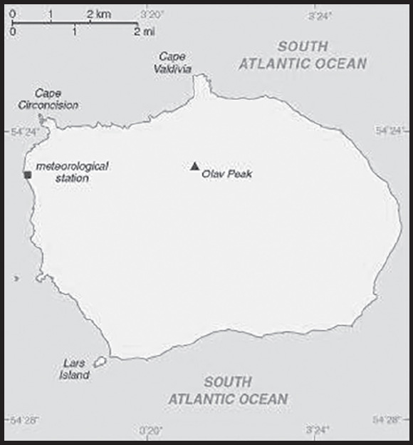
Background: This uninhabited, volcanic, Antarctic island is almost entirely covered by glaciers making it difficult to approach; it is recognized as the most remote island on Earth. (It is furthest in distance from any other point of land, 1,639 km from Antarctica.) Bouvet Island was discovered in 1739 by a French naval officer after whom it is named. No claim was made until 1825, when the British flag was raised. A few expeditions visited the island in the late 19th century. In 1929, the UK waived its claim in favor of Norway, which had occupied the island two years previously. In 1971, Norway designated Bouvet Island and the adjacent territorial waters a nature reserve. Since 1977, Norway has run an automated meteorological station and studied foraging strategies and distribution of fur seals and penguins on the island. In February 2006, an earthquake weakened the station’s foundation causing it to be blown out to sea in a winter storm. Norway erected a new research station in 2014 that can hold six people for periods of two to four months.
GEOGRAPHY
Location: island in the South Atlantic Ocean, southwest of the Cape of Good Hope (South Africa)
Geographic coordinates: 54 26 S, 3 24 E
Map references: Antarctic Region
Area: total: 49 sq km
land: 49 sq km
water: 0 sq km
comparison ranking: total 232
Area - comparative: about 0.3 times the size of Washington, DC
Land boundaries: total: 0 km
Coastline: 29.6 km
Maritime claims: territorial sea: 4 nm
Climate: antarctic
Terrain: volcanic; coast is mostly inaccessible
Elevation: highest point: Olavtoppen (Olav Peak) 780 m
lowest point: South Atlantic Ocean 0 m
Natural resources: none
Land use: agricultural land: 0% (2018 est.)
arable land: 0% (2018 est.)
permanent crops: 0% (2018 est.)
permanent pasture: 0% (2018 est.)
forest: 0% (2018 est.)
other: 100% (2018 est.)
Natural hazards: occasional volcanism, rock slides; harsh climate, surrounded by pack ice in winter
Geography - note: almost entirely covered by glacial ice (93%); declared a nature reserve by Norway; the distance from Bouvet Island to Norway is 12,776 km, which is almost one-third the circumference of the earth
PEOPLE AND SOCIETY
Population: uninhabited
ENVIRONMENT
Environment - current issues: none; almost entirely ice covered
Climate: antarctic
Land use: agricultural land: 0% (2018 est.)
arable land: 0% (2018 est.)
permanent crops: 0% (2018 est.)
permanent pasture: 0% (2018 est.)
forest: 0% (2018 est.)
other: 100% (2018 est.)
GOVERNMENT
Country name: conventional long form: none
conventional short form: Bouvet Island
etymology: named after the French naval officer Jean-Baptiste Charles BOUVET who discovered the island in 1739
note: pronounced boo-vay i-land
Dependency status: territory of Norway; administered by the Polar Department of the Ministry of Justice and Oslo Police
Legal system: the laws of Norway apply where applicable
Flag description: the flag of Norway is used
COMMUNICATIONS
Internet country code: .bv
Communications - note: has an automated meteorological station
TRANSPORTATION
Ports and terminals: none; offshore anchorage only
MILITARY AND SECURITY
Military - note: defense is the responsibility of Norway
TRANSNATIONAL ISSUES
Disputes - international: none identified
INTRODUCTION
Background: Following more than three centuries under Portuguese rule, Brazil gained its independence in 1822, maintaining a monarchical system of government until the abolition of slavery in 1888 and the subsequent proclamation of a republic by the military in 1889. Brazilian coffee exporters politically dominated the country until populist leader Getúlio VARGAS rose to power in 1930. VARGAS governed over various versions of democratic and authoritarian regimes from 1930 to 1945. Democratic rule returned (including a democratically elected VARGAS administration from 1951 to 1955) and lasted until 1964, when the military overthrew President João GOULART. The military regime censored journalists and repressed and tortured dissidents in the late 1960s and early 1970s. The dictatorship lasted until 1985, when the military regime peacefully ceded power to civilian rulers, and the Brazilian Congress passed its current constitution in 1989.
By far the largest and most populous country in South America, Brazil continues to pursue industrial and agricultural growth and development of its interior. Having successfully weathered a period of global financial difficulty in the late 20th century, under President Luiz Inácio LULA da Silva (2003-2010) Brazil was seen as one of the world’s strongest emerging markets and a contributor to global growth. The awarding of the 2014 FIFA World Cup and 2016 Summer Olympic Games, the first ever to be held in South America, was symbolic of the country’s rise. However, from about 2013 to 2016, Brazil was plagued by a sagging economy, high unemployment, and high inflation, only emerging from recession in 2017. Former President Dilma ROUSSEFF (2011-2016) was removed from office in 2016 by Congress for having committed impeachable acts against Brazil’s budgetary laws, and her vice president, Michel TEMER, served the remainder of her second term. A money-laundering investigation, Operation Lava Jato, uncovered a vast corruption scheme and prosecutors charged several high-profile Brazilian politicians with crimes. Former-President LULA was convicted of accepting bribes and served jail time (2018-19), although his conviction was overturned in early 2021. LULA’s revival became complete in October 2022 when he narrowly defeated incumbent Jair BOLSONARO (2019-2022) in the presidential election.
GEOGRAPHY
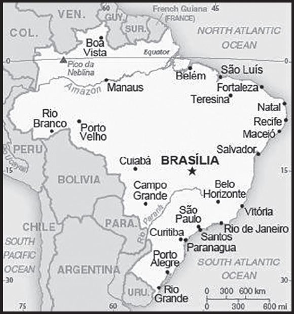
Location: Eastern South America, bordering the Atlantic Ocean
Geographic coordinates: 10 00 S, 55 00 W
Map references: South America
Area: total: 8,515,770 sq km
land: 8,358,140 sq km
water: 157,630 sq km
note: includes Arquipelago de Fernando de Noronha, Atol das Rocas, Ilha da Trindade, Ilhas Martin Vaz, and Penedos de Sao Pedro e Sao Paulo
comparison ranking: total 6
Area - comparative: slightly smaller than the US
Land boundaries: total: 16,145 km
border countries (10): Argentina 1,263 km; Bolivia 3,403 km; Colombia 1,790 km; French Guiana 649 km; Guyana 1,308 km; Paraguay 1,371 km; Peru 2,659 km; Suriname 515 km; Uruguay 1,050 km; Venezuela 2,137 km
Coastline: 7,491 km
Maritime claims: territorial sea: 12 nm
contiguous zone: 24 nm
exclusive economic zone: 200 nm
continental shelf: 200 nm or to edge of the continental margin
Climate: mostly tropical, but temperate in south
Terrain: mostly flat to rolling lowlands in north; some plains, hills, mountains, and narrow coastal belt
Elevation: highest point: Pico da Neblina 2,994 m
lowest point: Atlantic Ocean 0 m
mean elevation: 320 m
Natural resources: alumina, bauxite, beryllium, gold, iron ore, manganese, nickel, niobium, phosphates, platinum, tantalum, tin, rare earth elements, uranium, petroleum, hydropower, timber
Land use: agricultural land: 32.9% (2018 est.)
arable land: 8.6% (2018 est.)
permanent crops: 0.8% (2018 est.)
permanent pasture: 23.5% (2018 est.)
forest: 61.9% (2018 est.)
other: 5.2% (2018 est.)
Irrigated land: 69,029 sq km (2017)
Major lakes (area sq km): fresh water lake(s): Lagoa dos Patos - 10,140 sq km
salt water lake(s): Lagoa Mirim (shared with Uruguay) - 2,970 sq km
Major rivers (by length in km): Amazon river mouth (shared with Peru [s]) - 6,400 km; Río de la Plata/Paraná river source (shared with Paraguay, Argentina, and Uruguay [m]) - 4,880 km; Tocantins - 3,650 km; São Francisco - 3,180 km; Paraguay river source (shared with Argentina and Paraguay [m]) - 2,549 km; Rio Negro river mouth (shared with Colombia [s] and Venezuela) - 2,250 km; Uruguay river source (shared with Argentina and Uruguay [m]) - 1,610 km
note – [s] after country name indicates river source; [m] after country name indicates river mouth
Major watersheds (area sq km): Atlantic Ocean drainage: Amazon (6,145,186 sq km), Orinoco (953,675 sq km), Paraná (2,582,704 sq km), São Francisco (617,814 sq km), Tocantins (764,213 sq km)
Major aquifers: Amazon Basin, Guarani Aquifer System, Maranhao Basin
Population distribution: the vast majority of people live along, or relatively near, the Atlantic coast in the east; the population core is in the southeast, anchored by the cities of São Paolo, Brasília, and Rio de Janeiro
Natural hazards: recurring droughts in northeast; floods and occasional frost in south
Geography - note: note 1: largest country in South America and in the Southern Hemisphere; shares common boundaries with every South American country except Chile and Ecuador; most of the Pantanal, the world’s largest tropical wetland, extends through the west central part of the country; shares Iguaçu Falls (Iguazú Falls), the world’s largest waterfalls system, with Argentina
note 2: cassava (manioc) the sixth most important food crop in the world - after maize, rice, wheat, potatoes, and soybeans - seems to have originated in the west-central part of Brazil; pineapples are probably indigenous to the southern Brazil-Paraguay region
note 3: Rocas Atoll, located off the northeast coast of Brazil, is the only atoll in the South Atlantic
Rocas Atoll:
PEOPLE AND SOCIETY
Population: 218,689,757 (2023 est.)
comparison ranking: 7
Nationality: noun: Brazilian(s)
adjective: Brazilian
Ethnic groups: White 47.7%, mixed 43.1%, Black 7.6%, Asian 1.1%, Indigenous 0.4% (2010 est.)
Languages: Portuguese (official and most widely spoken language); note - less common languages include Spanish (border areas and schools), German, Italian, Japanese, English, and a large number of minor Amerindian languages
major-language sample(s): O Livro de Fatos Mundiais, a fonte indispensável para informação básica. (Brazilian Portuguese)
Religions: Roman Catholic 50%, Evangelical 31%, Spiritist 3%, Umbanda, Candomble, or other Afro-Brazilian religions 2%, Jewish 0.3%, atheist 1%, other 2%, none 10% (2020 est.)
Demographic profile: Brazil’s rapid fertility decline since the 1960s is the main factor behind the country’s slowing population growth rate, aging population, and fast-paced demographic transition. Brasilia has not taken full advantage of its large working-age population to develop its human capital and strengthen its social and economic institutions but is funding a study abroad program to bring advanced skills back to the country. The current favorable age structure will begin to shift around 2025, with the labor force shrinking and the elderly starting to compose an increasing share of the total population. Well-funded public pensions have nearly wiped out poverty among the elderly, and Bolsa Familia and other social programs have lifted tens of millions out of poverty. More than half of Brazil’s population is considered middle class, but poverty and income inequality levels remain high; the Northeast, North, and Center-West, women, and black, mixed race, and indigenous populations are disproportionately affected. Disparities in opportunities foster social exclusion and contribute to Brazil’s high crime rate, particularly violent crime in cities and favelas (slums).
Brazil has traditionally been a net recipient of immigrants, with its southeast being the prime destination. After the importation of African slaves was outlawed in the mid-19th century, Brazil sought Europeans (Italians, Portuguese, Spaniards, and Germans) and later Asians (Japanese) to work in agriculture, especially coffee cultivation. Recent immigrants come mainly from Argentina, Chile, and Andean countries (many are unskilled illegal migrants) or are returning Brazilian nationals. Since Brazil’s economic downturn in the 1980s, emigration to the United States, Europe, and Japan has been rising but is negligible relative to Brazil’s total population. The majority of these emigrants are well-educated and middle-class. Fewer Brazilian peasants are emigrating to neighboring countries to take up agricultural work.
Age structure: 0-14 years: 19.77% (male 22,084,172/female 21,148,290)
15-64 years: 69.72% (male 75,612,047/female 76,853,504)
65 years and over: 10.51% (2023 est.) (male 9,848,975/female 13,142,769)
Dependency ratios: total dependency ratio: 43.1
youth dependency ratio: 29.4
elderly dependency ratio: 13.7
potential support ratio: 7.3 (2021 est.)
Median age: total: 33.2 years (2020)
male: 32.3 years
female: 34.1 years
comparison ranking: total 101
Population growth rate: 0.64% (2023 est.)
comparison ranking: 134
Birth rate: 13.44 births/1,000 population (2023 est.)
comparison ranking: 133
Death rate: 6.9 deaths/1,000 population (2023 est.)
comparison ranking: 122
Net migration rate: -0.19 migrant(s)/1,000 population (2023 est.)
comparison ranking: 109
Population distribution: the vast majority of people live along, or relatively near, the Atlantic coast in the east; the population core is in the southeast, anchored by the cities of São Paolo, Brasília, and Rio de Janeiro
Urbanization: urban population: 87.8% of total population (2023)
rate of urbanization: 0.87% annual rate of change (2020-25 est.)
Major urban areas - population: 22.620 million São Paulo, 13.728 million Rio de Janeiro, 6.248 million Belo Horizonte, 4.873 million BRASÍLIA (capital), 4.264 million Recife, 4.212 million Porto Alegre (2023)
Sex ratio: at birth: 1.05 male(s)/female
0-14 years: 1.04 male(s)/female
15-64 years: 0.98 male(s)/female
65 years and over: 0.75 male(s)/female
total population: 0.97 male(s)/female (2023 est.)
Maternal mortality ratio: 72 deaths/100,000 live births (2020 est.)
comparison ranking: 86
Infant mortality rate: total: 13.11 deaths/1,000 live births (2023 est.)
male: 14.68 deaths/1,000 live births
female: 11.45 deaths/1,000 live births
comparison ranking: total 109
Life expectancy at birth: total population: 76.1 years (2023 est.)
male: 72.56 years
female: 79.81 years
comparison ranking: total population 114
Total fertility rate: 1.75 children born/woman (2023 est.)
comparison ranking: 153
Gross reproduction rate: 0.85 (2023 est.)
Contraceptive prevalence rate: 80.5% (2019)
Drinking water source: improved: urban: 99.8% of population
rural: 96.9% of population
total: 99.4% of population
unimproved: urban: 0.2% of population
rural: 3.1% of population
total: 0.6% of population (2020 est.)
Current health expenditure: 10.3% of GDP (2020)
Physicians density: 2.31 physicians/1,000 population (2019)
Hospital bed density: 2.1 beds/1,000 population (2017)
Sanitation facility access: improved: urban: 94.1% of population
rural: 63.6% of population
total: 90.2% of population
unimproved: urban: 5.9% of population
rural: 36.4% of population
total: 9.8% of population (2020 est.)
Major infectious diseases: degree of risk: very high (2023)
food or waterborne diseases: bacterial diarrhea and hepatitis A
vectorborne diseases: dengue fever and malaria
water contact diseases: schistosomiasis
Obesity - adult prevalence rate: 22.1% (2016)
comparison ranking: 81
Alcohol consumption per capita: total: 6.12 liters of pure alcohol (2019 est.)
beer: 3.84 liters of pure alcohol (2019 est.)
wine: 0.24 liters of pure alcohol (2019 est.)
spirits: 2 liters of pure alcohol (2019 est.)
other alcohols: 0.04 liters of pure alcohol (2019 est.)
comparison ranking: total 68
Tobacco use: total: 12.8% (2020 est.)
male: 16.2% (2020 est.)
female: 9.4% (2020 est.)
comparison ranking: total 119
Currently married women (ages 15-49): 55.9% (2023 est.)
Education expenditures: 6% of GDP (2019 est.)
comparison ranking: 41
Literacy: definition: age 15 and over can read and write
total population: 94.3%
male: 94.1%
female: 94.5% (2021)
School life expectancy (primary to tertiary education): total: 16 years
male: 15 years
female: 16 years (2020)
Youth unemployment rate (ages 15-24): total: 31.9% (2021 est.)
male: 27%
female: 38.2%
comparison ranking: total 32
ENVIRONMENT
Environment - current issues: deforestation in Amazon Basin destroys the habitat and endangers a multitude of plant and animal species indigenous to the area; illegal wildlife trade; illegal poaching; air and water pollution in Rio de Janeiro, Sao Paulo, and several other large cities; land degradation and water pollution caused by improper mining activities; wetland degradation; severe oil spills
Environment - international agreements: party to: Antarctic-Environmental Protection, Antarctic-Marine Living Resources, Antarctic Seals, Antarctic Treaty, Biodiversity, Climate Change, Climate Change-Kyoto Protocol, Climate Change-Paris Agreement, Comprehensive Nuclear Test Ban, Desertification, Endangered Species, Environmental Modification, Hazardous Wastes, Law of the Sea, Marine Dumping-London Convention, Nuclear Test Ban, Ozone Layer Protection, Ship Pollution, Tropical Timber 2006, Wetlands, Whaling
signed, but not ratified: Marine Dumping-London Protocol
Climate: mostly tropical, but temperate in south
Land use: agricultural land: 32.9% (2018 est.)
arable land: 8.6% (2018 est.)
permanent crops: 0.8% (2018 est.)
permanent pasture: 23.5% (2018 est.)
forest: 61.9% (2018 est.)
other: 5.2% (2018 est.)
Urbanization: urban population: 87.8% of total population (2023)
rate of urbanization: 0.87% annual rate of change (2020-25 est.)
Revenue from forest resources: 0.62% of GDP (2018 est.)
comparison ranking: 61
Revenue from coal: 0.01% of GDP (2018 est.)
comparison ranking: 51
Air pollutants: particulate matter emissions: 10.94 micrograms per cubic meter (2019 est.)
carbon dioxide emissions: 462.3 megatons (2016 est.)
methane emissions: 401.83 megatons (2020 est.)
Waste and recycling: municipal solid waste generated annually: 79,889,010 tons (2015 est.)
municipal solid waste recycled annually: 1,118,446 tons (2014 est.)
percent of municipal solid waste recycled: 1.4% (2014 est.)
Major lakes (area sq km): fresh water lake(s): Lagoa dos Patos - 10,140 sq km
salt water lake(s): Lagoa Mirim (shared with Uruguay) - 2,970 sq km
Major rivers (by length in km): Amazon river mouth (shared with Peru [s]) - 6,400 km; Río de la Plata/Paraná river source (shared with Paraguay, Argentina, and Uruguay [m]) - 4,880 km; Tocantins - 3,650 km; São Francisco - 3,180 km; Paraguay river source (shared with Argentina and Paraguay [m]) - 2,549 km; Rio Negro river mouth (shared with Colombia [s] and Venezuela) - 2,250 km; Uruguay river source (shared with Argentina and Uruguay [m]) - 1,610 km
note – [s] after country name indicates river source; [m] after country name indicates river mouth
Major watersheds (area sq km): Atlantic Ocean drainage: Amazon (6,145,186 sq km), Orinoco (953,675 sq km), Paraná (2,582,704 sq km), São Francisco (617,814 sq km), Tocantins (764,213 sq km)
Major aquifers: Amazon Basin, Guarani Aquifer System, Maranhao Basin
Total water withdrawal: municipal: 16.13 billion cubic meters (2020 est.)
industrial: 9.51 billion cubic meters (2020 est.)
agricultural: 41.42 billion cubic meters (2020 est.)
Total renewable water resources: 8.65 trillion cubic meters (2020 est.)
GOVERNMENT
Country name: conventional long form: Federative Republic of Brazil
conventional short form: Brazil
local long form: República Federativa do Brasil
local short form: Brasil
etymology: the country name derives from the brazilwood tree that used to grow plentifully along the coast of Brazil and that was used to produce a deep red dye
Government type: federal presidential republic
Capital: name: Brasília
geographic coordinates: 15 47 S, 47 55 W
time difference: UTC-3 (2 hours ahead of Washington, DC, during Standard Time)
time zone note: Brazil has four time zones, including one for the Fernando de Noronha Islands
etymology: name bestowed on the new capital of Brazil upon its inauguration in 1960; previous Brazilian capitals had been Salvador from 1549 to 1763 and Rio de Janeiro from 1763 to 1960
Administrative divisions: 26 states (estados, singular - estado) and 1 federal district* (distrito federal); Acre, Alagoas, Amapa, Amazonas, Bahia, Ceara, Distrito Federal*, Espirito Santo, Goias, Maranhao, Mato Grosso, Mato Grosso do Sul, Minas Gerais, Para, Paraiba, Parana, Pernambuco, Piaui, Rio de Janeiro, Rio Grande do Norte, Rio Grande do Sul, Rondonia, Roraima, Santa Catarina, Sao Paulo, Sergipe, Tocantins
Independence: 7 September 1822 (from Portugal)
National holiday: Independence Day, 7 September (1822)
Constitution: history: several previous; latest ratified 5 October 1988
amendments: proposed by at least one third of either house of the National Congress, by the president of the republic, or by simple majority vote by more than half of the state legislative assemblies; passage requires at least three-fifths majority vote by both houses in each of two readings; constitutional provisions affecting the federal form of government, separation of powers, suffrage, or individual rights and guarantees cannot be amended; amended many times, last in 2022
Legal system: civil law; note - a new civil law code was enacted in 2002 replacing the 1916 code
International law organization participation: has not submitted an ICJ jurisdiction declaration; accepts ICCt jurisdiction
Citizenship: citizenship by birth: yes
citizenship by descent only: yes
dual citizenship recognized: yes
residency requirement for naturalization: 4 years
Suffrage: voluntary between 16 to 18 years of age, over 70, and if illiterate; compulsory between 18 to 70 years of age; note - military conscripts by law cannot vote
Executive branch: chief of state: President Luiz Inácio LULA da Silva (since 1 January 2023); Vice President Geraldo José Rodrigues ALCKMIN Filho (since 1 January 2023); note - the president is both chief of state and head of government
head of government: President Luiz Inácio LULA da Silva (since 1 January 2023); Vice President Geraldo José Rodrigues ALCKMIN Filho (since 1 January 2023)
cabinet: Cabinet appointed by the president
elections/appointments: president and vice president directly elected on the same ballot by absolute majority popular vote in 2 rounds if needed for a 4-year term (eligible for a single consecutive term, and additional terms after at least one term has elapsed); election last held on 2 October 2022 with runoff on 30 October 2022 (next to be held on 4 October 2026)
election results:
2022: Luiz Inácio LULA da Silva elected president in second round; percent of vote in first round - Luiz Inácio LULA da Silva (PT) 48.4%, Jair BOLSONARO (PSL) 43.2%, Simone Nassar TEBET (MDB) 4.2%, Ciro GOMES (PDT) 3%, other 1.2%; percent of vote in second round - Luiz Inácio LULA da Silva (PT) 50.9%, Jair BOLSONARO (PSL) 49.1%
2018: Jair BOLSONARO elected president in second round; percent of vote in first round - Jair BOLSONARO (PSL) 46%, Fernando HADDAD (PT) 29.3%, Ciro GOMEZ (PDT) 12.5%, Geraldo ALCKMIN (PSDB) 4.8%, other 7.4%; percent of vote in second round - Jair BOLSONARO (PSL) 55.1%, Fernando HADDAD (PT) 44.9%
Legislative branch: description: bicameral National Congress or Congresso Nacional consists of:
Federal Senate or Senado Federal (81 seats; 3 members each from 26 states and 3 from the federal district directly elected in multi-seat constituencies by simple majority vote to serve 8-year terms, with one-third and two-thirds of the membership elected alternately every 4 years)
Chamber of Deputies or Camara dos Deputados (513 seats; members directly elected in multi-seat constituencies by open party-list proportional representation vote to serve 4-year terms)
elections:
Federal Senate - last held on 2 October 2022 for one-third of the Senate (next to be held on 4 October 2026 for two-thirds of the seats)
Chamber of Deputies - last held on 2 October 2022 (next to be held on 4 October 2026)
election results:
Federal Senate - percent of vote by party - NA; seats by party - PL 13, Brazil Union 12, MBD 10, PSD 10, PT 9, Progressistas 7, Podemos 6, PSDB 4, Republicans 3, PDT 2, Cidadania 1, PSB 1, PSC 1, PROS 1, REDE 1; composition - men 66, women 15, percent of women 18.5%
Chamber of Deputies - percent of vote by party - NA; seats by party - PL 99, PT 67, Brazil Union 59, PP 47, MDB 42, PSD 42, Republicans 41, PDT 17, PSB 14, PSDB 13, Podemos 12, PSOL 12, Avante 7, PCdoB 6, PSC 6, PV 6, Cidadania 5, Patriota 4, PROS 4, SD 4, NOVO 3, REDE 2, PTB 1; composition - men 423, women 90, percent of women 17.5%; note - total National Congress percent of women 17.7%
Judicial branch: highest court(s): Supreme Federal Court or Supremo Tribunal Federal (consists of 11 justices)
judge selection and term of office: justices appointed by the president and approved by the Federal Senate; justices appointed to serve until mandatory retirement at age 75
subordinate courts: Tribunal of the Union, Federal Appeals Court, Superior Court of Justice, Superior Electoral Court, regional federal courts; state court system
Political parties and leaders: Act (Agir) [Daniel TOURINHO] (formerly Christian Labor Party or PTC)
Avante [Luis Henrique de Oliveira RESENDE] (formerly Labor Party of Brazil or PTdoB)
Brazil Union (União Brasil); note - founded from a merger between the Democrats (DEM) and the Social Liberal Party (PSL)
Brazilian Communist Party or PCB [Astrogildo PEREIRA]
Brazilian Democratic Movement or MDB [Luiz Felipe Baleia TENUTO Rossi]
Brazilian Labor Party or PTB [Kassyo Santos RAMOS]
Brazilian Renewal Labor Party or PRTB [Júlio Cezar FIDELIX da Cruz]
Brazilian Labor Party or PTB
Brazilian Social Democracy Party or PSDB [Bruno Cavalcanti de ARAÚJO]
Brazilian Socialist Party or PSB [Carlos Roberto SIQUEIRA de Barros]
Christian Democracy or DC [José Maria EYMAEL] (formerly Christian Social
Cidadania [Roberto João Pereira FREIRE] (formerly Popular Socialist Party or PPS)
Communist Party of Brazil or PCdoB [Luciana SANTOS]
Democratic Labor Party or PDT [Ciro FERREIRA Gomes]
Democratic Party or PSDC
Democrats or DEM [Jose AGRIPINO] (formerly Liberal Front Party or PFL); note - dissolved in February 2022
Green Party or PV [José Luiz PENNA]
Liberal Party or PL [Valdemar Costa Neto] (formerly Party of the Republic or PR)
National Mobilization Party or PMN [Antonio Carlos Bosco MASSAROLLO]
New Party or NOVO [Eduardo RIBEIRO]
Patriota [Ovasco RESENDE] (formerly National Ecologic Party or PEN)
Podemos [Renata ABREU] (formerly National Labor Party or PTN)
Progressive Party (Progressistas) or PP [Ciro NOGUEIRA Lima Filho]
Republican Social Order Party or PROS [Euripedes JUNIOR]
Republicans (Republicanos) [Marcos Antônio PEREIRA] (formerly Brazilian Republican Party or PRB)
Social Christian Party or PSC [Everaldo Dias PEREIRA]
Social Democratic Party or PSD [Alfredo COATIT Neto]
Social Liberal Party or PSL [Luciano Caldas BIVAR]
Socialism and Freedom Party or PSOL [Juliano MEDEIROS]
Solidarity or SD [Paulinho DA FORÇA]
Sustainability Network or REDE [Marina SILVA]
United Socialist Workers’ Party or PSTU [José Maria DE ALMEIDA]
Workers’ Cause Party or PCO [Rui Costa PIMENTA]
Workers’ Party or PT [Gleisi Helena HOFFMANN]
International organization participation: AfDB (nonregional member), BIS, BRICS, CAN (associate), CD, CELAC, CPLP, FAO, FATF, G-15, G-20, G-24, G-5, G-77, IADB, IAEA, IBRD, ICAO, ICC (national committees), ICCt, ICRM, IDA, IFAD, IFC, IFRCS, IHO, ILO, IMF, IMO, IMSO, Interpol, IOC, IOM, IPU, ISO, ITSO, ITU, ITUC (NGOs), LAES, LAIA, LAS (observer), Mercosur, MIGA, MINURSO, MINUSTAH, MONUSCO, NAM (observer), NSG, OAS, OECD (enhanced engagement), OPANAL, OPCW, Paris Club (associate), PCA, PROSUR, SICA (observer), UN, UNASUR, UNCTAD, UNESCO, UNFICYP, UNHCR, UNHRC, UNIDO, UNISFA, UNIFIL, Union Latina, UNISFA, UNITAR, UNMIL, UNMISS, UNOCI, UNRWA, UNWTO, UPU, WCO, WFTU (NGOs), WHO, WIPO, WMO, WTO
Diplomatic representation in the US: chief of mission: Ambassador Maria Luiza Ribeiro VIOTTI (since 30 June 2023)
chancery: 3006 Massachusetts Avenue NW, Washington, DC 20008
telephone: [1] (202) 238-2700
FAX: [1] (202) 238-2827
email address and website:
ambassador.dc@itamaraty.gov.br
https://www.gov.br/mre/pt-br/embaixada-washington
consulate(s) general: Atlanta, Boston, Chicago, Hartford (CT), Houston, Los Angeles, Miami, New York, San Francisco, Washington, DC
Diplomatic representation from the US: chief of mission: Ambassador Elizabeth Frawley BAGLEY (since 5 February 2023)
embassy: SES - Avenida das Nações, Quadra 801, Lote 3, 70403-900 - Brasília, DF
mailing address: 7500 Brasilia Place, Washington DC 20521-7500
telephone: [55] (61) 3312-7000
FAX: [55] (61) 3225-9136
email address and website:
consulate(s) general: Recife, Porto Alegre, Rio de Janeiro, São Paulo
branch office(s): Belo Horizonte
Flag description: green with a large yellow diamond in the center bearing a blue celestial globe with 27 white five-pointed stars; the globe has a white equatorial band with the motto ORDEM E PROGRESSO (Order and Progress); the current flag was inspired by the banner of the former Empire of Brazil (1822-1889); on the imperial flag, the green represented the House of Braganza of Pedro I, the first Emperor of Brazil, while the yellow stood for the Habsburg Family of his wife; on the modern flag the green represents the forests of the country and the yellow rhombus its mineral wealth (the diamond shape roughly mirrors that of the country); the blue circle and stars, which replaced the coat of arms of the original flag, depict the sky over Rio de Janeiro on the morning of 15 November 1889 - the day the Republic of Brazil was declared; the number of stars has changed with the creation of new states and has risen from an original 21 to the current 27 (one for each state and the Federal District)
note: one of several flags where a prominent component of the design reflects the shape of the country; other such flags are those of Bosnia and Herzegovina, Eritrea, and Vanuatu
National symbol(s): Southern Cross constellation; national colors: green, yellow, blue
National anthem: name: “Hino Nacional Brasileiro” (Brazilian National Anthem)
lyrics/music: Joaquim Osorio Duque ESTRADA/Francisco Manoel DA SILVA
note: music adopted 1890, lyrics adopted 1922; the anthem’s music, composed in 1822, was used unofficially for many years before it was adopted
National heritage: total World Heritage Sites: 23 (15 cultural, 7 natural, 1 mixed)
selected World Heritage Site locales: Brasilia (c); Historic Salvador de Bahia (c); Historic Ouro Preto (c); Historic Olinda (c); Iguaçu National Park (n); Jesuit Missions of the Guaranis (c); Rio de Janeiro: Carioca Landscapes (c); Central Amazon Conservation Complex (n); Atlantic Forest South-East Reserves (n); Paraty and Ilha Grande – Culture and Biodiversity (m)
ECONOMY
Economic overview: industrial-led economic growth model; recovering from 2014-2016 recession when COVID-19 hit; industry limited by Amazon rainforest but increasing deforestation; new macroeconomic structural reforms; high income inequality; left UNASUR to join PROSUR
Real GDP (purchasing power parity): $3.128 trillion (2021 est.)
$2.989 trillion (2020 est.)
$3.11 trillion (2019 est.)
note: data are in 2017 dollars
comparison ranking: 9
Real GDP growth rate: 4.62% (2021 est.)
-3.88% (2020 est.)
1.22% (2019 est.)
comparison ranking: 99
Real GDP per capita: $14,600 (2021 est.)
$14,000 (2020 est.)
$14,700 (2019 est.)
note: data are in 2017 dollars
comparison ranking: 111
GDP (official exchange rate): $1,877,942,000,000 (2019 est.)
Inflation rate (consumer prices): 8.3% (2021 est.)
3.21% (2020 est.)
3.73% (2019 est.)
comparison ranking: 33
Credit ratings: Fitch rating: BB (2023)
Moody’s rating: Ba2 (2016)
Standard & Poors rating: BB- (2018)
note: The year refers to the year in which the current credit rating was first obtained.
GDP - composition, by sector of origin: agriculture: 6.6% (2017 est.)
industry: 20.7% (2017 est.)
services: 72.7% (2017 est.)
comparison rankings: services 60; industry 142; agriculture 116
GDP - composition, by end use: household consumption: 63.4% (2017 est.)
government consumption: 20% (2017 est.)
investment in fixed capital: 15.6% (2017 est.)
investment in inventories: -0.1% (2017 est.)
exports of goods and services: 12.6% (2017 est.)
imports of goods and services: -11.6% (2017 est.)
Agricultural products: sugar cane, soybeans, maize, milk, cassava, oranges, poultry, rice, beef, cotton
Industries: textiles, shoes, chemicals, cement, lumber, iron ore, tin, steel, aircraft, motor vehicles and parts, other machinery and equipment
Industrial production growth rate: 4.48% (2021 est.)
comparison ranking: 99
Labor force: 99.47 million (2021 est.)
comparison ranking: 5
Labor force - by occupation: agriculture: 9.4%
industry: 32.1%
services: 58.5% (2017 est.)
Unemployment rate: 14.4% (2021 est.)
13.69% (2020 est.)
11.93% (2019 est.)
comparison ranking: 39
Youth unemployment rate (ages 15-24): total: 31.9% (2021 est.)
male: 27%
female: 38.2%
comparison ranking: total 32
Population below poverty line: 4.2% (2016 est.)
note: approximately 4% of the population are below the “extreme” poverty line
Gini Index coefficient - distribution of family income: 48.9 (2020 est.)
comparison ranking: 15
Average household expenditures: on food: 15.7% of household expenditures (2018 est.)
on alcohol and tobacco: 1.5% of household expenditures (2018 est.)
Household income or consumption by percentage share: lowest 10%: 0.8%
highest 10%: 43.4% (2016 est.)
Budget: revenues: $424.196 billion (2020 est.)
expenditures: $617.332 billion (2020 est.)
Budget surplus (+) or deficit (-): -1.1% (of GDP) (2017 est.)
comparison ranking: 84
Public debt: 100.59% of GDP (2020 est.)
92.57% of GDP (2019 est.)
86.61% of GDP (2018 est.)
comparison ranking: 23
Taxes and other revenues: 12.96% (of GDP) (2020 est.)
comparison ranking: 170
Fiscal year: calendar year
Current account balance: -$27.925 billion (2021 est.)
-$24.492 billion (2020 est.)
-$65.03 billion (2019 est.)
comparison ranking: 206
Exports: $317.175 billion (2021 est.)
$239.283 billion (2020 est.)
$260.075 billion (2019 est.)
note: Data are in current year dollars and do not include illicit exports or re-exports.
comparison ranking: 25
Exports - partners: China 28%, United States 13% (2019)
Exports - commodities: iron, soybeans, crude petroleum, sugar, poultry meats (2021)
Imports: $297.924 billion (2021 est.) note: data are in current year dollars
$227.854 billion (2020 est.) note: data are in current year dollars
$269.017 billion (2019 est.) note: data are in current year dollars
comparison ranking: 24
Imports - partners: China 21%, United States 18%, Germany 6%, Argentina 6% (2019)
Imports - commodities: refined petroleum, vehicle parts, crude petroleum, integrated circuits, pesticides (2019)
Reserves of foreign exchange and gold: $362.21 billion (31 December 2021 est.)
$355.614 billion (31 December 2020 est.)
$356.886 billion (31 December 2019 est.)
comparison ranking: 12
Debt - external: $681.336 billion (2019 est.)
$660.693 billion (2018 est.)
comparison ranking: 20
Exchange rates: reals (BRL) per US dollar -
Exchange rates: 5.394 (2021 est.)
5.155 (2020 est.)
3.944 (2019 est.)
3.654 (2018 est.)
3.191 (2017 est.)
ENERGY
Electricity access: electrification - total population: 99.4% (2021)
electrification - urban areas: 99.7% (2021)
electrification - rural areas: 97.3% (2021)
Electricity: installed generating capacity: 195.037 million kW (2020 est.)
consumption: 540,997,340,000 kWh (2020 est.)
exports: 395 million kWh (2020 est.)
imports: 25.113 billion kWh (2020 est.)
transmission/distribution losses: 105.727 billion kWh (2020 est.)
comparison rankings: transmission/distribution losses 4; imports 6; exports 78; consumption 6; installed generating capacity 7
Electricity generation sources: fossil fuels: 11.8% of total installed capacity (2020 est.)
nuclear: 2.3% of total installed capacity (2020 est.)
solar: 1.7% of total installed capacity (2020 est.)
wind: 9.2% of total installed capacity (2020 est.)
hydroelectricity: 65.8% of total installed capacity (2020 est.)
biomass and waste: 9.2% of total installed capacity (2020 est.)
Nuclear energy: Number of operational nuclear reactors: 2 (2023)
Number of nuclear reactors under construction: 1
Net capacity of operational nuclear reactors: 1.88GW (2023)
Percent of total electricity production: 2.5% (2021)
Percent of total energy produced: 1% (2021)
Number of nuclear reactors permanently shut down: 0
Coal: production: 13.993 million metric tons (2020 est.)
consumption: 31.841 million metric tons (2020 est.)
exports: 16,000 metric tons (2020 est.)
imports: 19.217 million metric tons (2020 est.)
proven reserves: 6.596 billion metric tons (2019 est.)
Petroleum: total petroleum production: 3,629,100 bbl/day (2021 est.)
refined petroleum consumption: 3,142,300 bbl/day (2019 est.)
crude oil and lease condensate exports: 1,123,300 bbl/day (2018 est.)
crude oil and lease condensate imports: 186,200 bbl/day (2018 est.)
crude oil estimated reserves: 12,714,600,000 barrels (2021 est.)
Refined petroleum products - production: 2.811 million bbl/day (2015 est.)
comparison ranking: 7
Refined petroleum products - exports: 279,000 bbl/day (2015 est.)
comparison ranking: 28
Refined petroleum products - imports: 490,400 bbl/day (2015 est.)
comparison ranking: 17
Natural gas: production: 25,395,979,000 cubic meters (2019 est.)
consumption: 35,253,198,000 cubic meters (2019 est.)
exports: 0 cubic meters (2021 est.)
imports: 9,724,017,000 cubic meters (2019 est.)
proven reserves: 363.984 billion cubic meters (2021 est.)
Carbon dioxide emissions: 456.67 million metric tonnes of CO2 (2019 est.)
from coal and metallurgical coke: 63.53 million metric tonnes of CO2 (2019 est.)
from petroleum and other liquids: 328.824 million metric tonnes of CO2 (2019 est.)
from consumed natural gas: 64.316 million metric tonnes of CO2 (2019 est.)
comparison ranking: total emissions 14
Energy consumption per capita: 59.444 million Btu/person (2019 est.)
comparison ranking: 93
COMMUNICATIONS
Telephones - fixed lines: total subscriptions: 28,883,475 (2021 est.)
subscriptions per 100 inhabitants: 13 (2021 est.)
comparison ranking: total subscriptions 8
Telephones - mobile cellular: total subscriptions: 219,660,524 (2021 est.)
subscriptions per 100 inhabitants: 102 (2021 est.)
comparison ranking: total subscriptions 6
Telecommunication systems: general assessment: Brazil is one of the largest mobile and broadband markets in Latin America with healthy competition and pricing; 5G services was provided to all capital cities in July 2022, as well as about 35,500km of the national highway network; the country also has one of the largest fixed line broadband markets in Latin America, though broadband subscriptions is only slightly above the regional average, trailing behind Chile, Argentina, and Uruguay; amendments to the licensing regime adopted in October 2019 also require that ISPs which have switched to authorizations invest money saved from lighter regulations in the expansion of broadband services; the fixed line broadband market has seen rapid growth for a number of years, with a growing focus on fiber broadband; in 2019 the number of fiber accesses overtook DSL connections; the country is a key landing point for a number of important submarine cables connecting to the US, Central and South America, the Caribbean, Europe, and Africa; several new cable systems are due to come into service through to 2022, which will increase bandwidth and push down broadband prices for end-users; investments have also been made into terrestrial fiber cables between Brazil, Argentina, and Chile (2022)
domestic: fixed-line connections stand at roughly 13 per 100 persons; mobile-cellular teledensity roughly 102 per 100 persons (2021)
international: country code - 55; landing points for a number of submarine cables, including Malbec, ARBR, Tamnat, SAC, SAm-1, Atlantis -2, Seabras-1, Monet, EllaLink, BRUSA, GlobeNet, AMX-1, Brazilian Festoon, Bicentenario, Unisur, Junior, Americas -II, SAE x1, SAIL, SACS and SABR that provide direct connectivity to South and Central America, the Caribbean, the US, Africa, and Europe; satellite earth stations - 3 Intelsat (Atlantic Ocean), 1 Inmarsat (Atlantic Ocean region east), connected by microwave relay system to Mercosur Brazilsat B3 satellite earth station; satellites is a major communication platform, as it is almost impossible to lay fiber optic cable in the thick vegetation (2019)
Broadcast media: state-run Radiobras operates a radio and a TV network; more than 1,000 radio stations and more than 100 TV channels operating - mostly privately owned; private media ownership highly concentrated (2022)
Internet country code: .br
Internet users: total: 170.1 million (2021 est.)
percent of population: 81% (2021 est.)
comparison ranking: total 4
Broadband - fixed subscriptions: total: 36,344,670 (2020 est.)
subscriptions per 100 inhabitants: 17 (2020 est.)
comparison ranking: total 4
TRANSPORTATION
National air transport system: number of registered air carriers: 9 (2020)
inventory of registered aircraft operated by air carriers: 443
annual passenger traffic on registered air carriers: 102,109,977 (2018)
annual freight traffic on registered air carriers: 1,845,650,000 (2018) mt-km
Civil aircraft registration country code prefix: PP
Airports: 4,093 (2021)
comparison ranking: total 2
Airports - with paved runways: 698
civil airports: 35
military airports: 14
joint use (civil-military) airports: 17
other airports: 632
note: paved runways have a concrete or asphalt surface but not all have facilities for refueling, maintenance, or air traffic control; the length of a runway required for aircraft to safely operate depends on a number of factors including the type of aircraft, the takeoff weight (including passengers, cargo, and fuel), engine types, flap settings, landing speed, elevation of the airport, and average maximum daily air temperature; paved runways can reach a length of 5,000 m (16,000 ft.), but the “typical” length of a commercial airline runway is between 2,500-4,000 m (8,000-13,000 ft.)
Airports - with unpaved runways: 3,395
note: unpaved runways have a surface composition such as grass or packed earth and are most suited to the operation of light aircraft; unpaved runways are usually short, often less than 1,000 m (3,280 ft.) in length; airports with unpaved runways often lack facilities for refueling, maintenance, or air traffic control
Heliports: 13 (2021)
Pipelines: 5,959 km refined petroleum product (1,165 km distribution, 4,794 km transport), 11,696 km natural gas (2,274 km distribution, 9,422 km transport), 1,985 km crude oil (distribution), 77 km ethanol/petrochemical (37 km distribution, 40 km transport) (2016)
Railways: total: 29,849.9 km (2014)
standard gauge: 194 km (2014) 1.435-m gauge
narrow gauge: 23,341.6 km (2014) 1.000-m gauge (24 km electrified)
broad gauge: 5,822.3 km (2014) 1.600-m gauge (498.3 km electrified)
dual gauge: 492 km (2014) 1.600-1.000-m gauge
comparison ranking: total 8
Roadways: total: 2 million km (2018)
paved: 246,000 km (2018)
unpaved: 1.754 million km (2018)
comparison ranking: total 4
Waterways: 50,000 km (2012) (most in areas remote from industry and population)
comparison ranking: 2
Merchant marine: total: 877 (2022)
by type: bulk carrier 11, container ship 20, general cargo 40, oil tanker 27, other 779
comparison ranking: total 26
Ports and terminals: major seaport(s): Belem, Itajai, Paranagua, Rio Grande, Rio de Janeiro, Santos, Sao Sebastiao, Tubarao
oil terminal(s): DTSE/Gegua oil terminal, Ilha Grande (Gebig), Guaiba Island terminal, Guamare oil terminal
container port(s) (TEUs): Itajai (1,610,092), Paranagua (1,044,157), Santos (4,442,876) (2021)
LNG terminal(s) (import): Pecem, Rio de Janiero
river port(s): Manaus (Amazon)
dry bulk cargo port(s): Sepetiba ore terminal, Tubarao
MILITARY AND SECURITY
Military and security forces: Brazilian Armed Forces (Forças Armadas Brasileiras): Brazilian Army (Exercito Brasileiro, EB), Brazilian Navy (Marinha do Brasil, MB, includes Naval Aviation (Aviacao Naval Brasileira) and Marine Corps (Corpo de Fuzileiros Navais)), Brazilian Air Force (Forca Aerea Brasileira, FAB) (2023)
note: Brazil’s Federal Police are under the Minister of Justice and Public Security
Military expenditures: 1.2% of GDP (2022 est.)
1.3% of GDP (2021 est.)
1.4% of GDP (2020 est.)
1.4% of GDP (2019 est.)
1.5% of GDP (2018 est.)
comparison ranking: 108
Military and security service personnel strengths: approximately 360,000 active military personnel (220,000 Army; 70,000 Navy; 70,000 Air Force); approximately 400,000 paramilitary security forces (2023)
Military equipment inventories and acquisitions: the Brazilian military’s inventory consists of a mix of domestically produced and imported weapons, largely from Europe and the US; in recent years, the US and several European countries have been the leading suppliers of military equipment to Brazil; Brazil’s defense industry designs and manufactures equipment for all three military services and for export; it also jointly produces equipment with other countries (2023)
Military service age and obligation: 18-45 years of age for compulsory military service for men (women exempted); only 5-10% of those inducted are required to serve; conscript service obligation is 10-12 months; 17-45 years of age for voluntary service (2023)
note: in 2022, women comprised approximately 9% of the Brazilian military
Military - note: the Brazilian Armed Forces (BAF) are the second largest military in the Western Hemisphere behind the US; while they are responsible for external security and protecting the country’s sovereignty, Brazil does not have any territorial disputes with its neighbors or regional rivalries; the BAF’s missions include patrolling and protecting the country’s long borders and coastline and extensive territorial waters and river network, assisting with internal security, providing domestic disaster response and humanitarian assistance, and participating in multinational peacekeeping missions
the Army has a considerable internal security role; in the past decade, it has mobilized thousands of troops to conduct counternarcotics operations, support the police in combating crime, assist with disease outbreaks and humanitarian missions, and provide security for major events such as the 2014 World Cup and the 2016 Summer Olympics; it has also cooperated with neighboring countries such as Argentina and Paraguay on border security to combat smuggling and trafficking; the Army is organized into regional commands, military regions, and geographically based divisions covering the entirety of the country; it has approximately 30 combat brigades which include light, mechanized, or motorized infantry, light armored/cavalry, special operations, artillery, and helicopter forces; many of the light infantry brigades are specialized for air mobile, airborne, jungle, mountain, or urban warfare operations; the Army has established a battalion-sized (1,000 troops) expeditionary force for foreign international missions that it plans to increase to a 3,000-strong brigade by 2030
the Navy conducts coastal, regional, and riverine operations and has a wide variety of missions ranging from sea patrolling and power projection to countering piracy, illegal fishing, narcotics trafficking, and organized crime; it is organized into 9 districts covering the entirety of the country; the Navy’s principal warships include approximately 14 frigates, corvettes, and offshore patrol ships, 7 attack submarines, and a multi-purpose helicopter landing platform (LPH) amphibious assault ship that serves as the fleet’s flagship; it also has a considerable coastal and riverine patrol vessel fleet, an aviation wing with about 50 combat aircraft and helicopters, and a marine amphibious force
the Air Force has over 100 fighter and ground attack aircraft, as well as dozens of support aircraft and helicopters for missions such as patrolling, reconnaissance, transport, logistics, special missions, and training
the three national police forces – the Federal Police, Federal Highway Police, and Federal Railway Police – have domestic security responsibilities and report to the Ministry of Justice and Public Security (Ministry of Justice); there are two distinct units within the state police forces: the civil police, which performs an investigative role, and the military police, charged with maintaining law and order in the states and the Federal District; despite the name, military police forces report to the Ministry of Justice, not the Ministry of Defense; the National Public Security Force (Forca Nacional de Seguranca Publica or SENASP) is a national police force made up of Military Police from various states; the armed forces also have some domestic security responsibilities and report to the Ministry of Defense
Brazil has Major Non-NATO Ally (MNNA) status with the US, a designation under US law that provides foreign partners with certain benefits in the areas of defense trade and security cooperation
the origins of Brazil’s military stretch back to the 1640s; Brazil provided a 25,000-man expeditionary force with air and ground units to fight with the Allies in the Mediterranean Theater during World War II; the Navy participated in the Battle of the Atlantic (2023)
SPACE
Space agency/agencies: Brazilian Space Agency (Agência Espacial Brasileira, AEB; established in 1994 when Brazil’s space program was transferred from the military to civilian control); National Institute for Space Research (established, 1971; part of the Brazilian Ministry of Science, Technology and Innovations); Space Operations Command (Armed Forces); Department of Aerospace Science and Technology (DCTA; established in 1953 as a military space research program under the Brazilian Air Force) (2023)
Space launch site(s): Alcantara Launch Site (Maranhão state); Barreira do Inferno Launch Center (Rio Grande do Norte state) (2023)
Space program overview: has an active program with a long history, although it has been hampered by inconsistent funding; develops, builds, operates, and tracks satellites, including communications, remote sensing (RS), multi-mission, navigational, and scientific/testing/research; satellites are launched by foreign partners, but Brazil has a long-standing sounding (research) rocket and space launch vehicle (SLV) program and rocket launch facilities; cooperates with a variety of foreign space agencies and commercial entities, including those of Argentina, Canada, the European Space Agency and individual member states (particularly France and Germany), India, Japan, Russia, South Africa, South Korea, Ukraine, and the US; has a state-controlled communications company that operates Brazil’s communications satellites and a growing commercial space sector with expertise in satellite technology (2023)
note: further details about the key activities, programs, and milestones of the country’s space program, as well as government spending estimates on the space sector, appear in Appendix S
TERRORISM
Terrorist group(s): Terrorist group(s): Hizballah (2022)
note: details about the history, aims, leadership, organization, areas of operation, tactics, targets, weapons, size, and sources of support of the group(s) appear(s) in Appendix-T
TRANSNATIONAL ISSUES
Disputes - international: Brazil-Bolivia: the Roboré Accord of March 29, 1958 placed the long-disputed Isla Suárez/Ilha de Guajará-Mirim, a fluvial island on the Río Mamoré, between the two towns of Guajará-Mirim (Brazil) and Guayaramerin (Bolivia), under Bolivian administration but did not resolve the sovereignty dispute
Brazil-Colombia: contraband smuggling (narcotics and arms), illegal migration, trafficking in animals, plants, lumber, illegal exploitation of mineral resources, and incursions by Colombian insurgent/narco-terrorists groups in the area remain problematic issues
Brazil-Uruguay: the uncontested boundary dispute between Brazil and Uruguay over Arroyo de la Invernada triangle and sovereignty over Isla Brasilera leaves the tripoint with Argentina in question; smuggling of firearms and narcotics continues to be an issue along the Uruguay-Brazil border
Brazil-Venezuela: Colombian-organized illegal narcotics and paramilitary activities penetrate Brazil’s border region with Venezuela
Refugees and internally displaced persons: refugees (country of origin): 449,678 (Venezuela) (economic and political crisis; includes Venezuelans who have claimed asylum, are recognized as refugees, or received alternative legal stay) (2023)
IDPs: 5,600 (2022)
stateless persons: 12 (2022)
Illicit drugs: a significant drug transit and destination country for cocaine bound for Europe and other destinations including the United States; domestic drug use and addiction is a significant problem and it is second only to the United States in cocaine consumption; a major source of precursor or essential chemicals used in the production of illicit narcotics
BRITISH INDIAN OCEAN TERRITORY
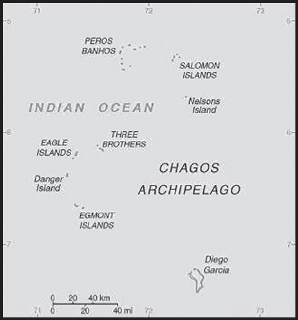
INTRODUCTION
Background: Formerly administered as part of the British Crown Colony of Mauritius, the British Indian Ocean Territory (BIOT) was established as an overseas territory of the UK in 1965. A number of the islands of the territory were later transferred to the Seychelles when it attained independence in 1976. Subsequently, BIOT has consisted only of the six main island groups comprising the Chagos Archipelago. Only Diego Garcia, the largest and most southerly of the islands, is inhabited. It contains a joint UK-US naval support facility and hosts one of four dedicated ground antennas that assist in the operation of the Global Positioning System (GPS) navigation system (the others are on Kwajalein (Marshall Islands), at Cape Canaveral, Florida (US), and on Ascension Island (Saint Helena, Ascension, and Tristan da Cunha)). The US Air Force also operates a telescope array on Diego Garcia as part of the Ground-Based Electro-Optical Deep Space Surveillance System (GEODSS) for tracking orbital debris, which can be a hazard to spacecraft and astronauts.
Between 1967 and 1973, former agricultural workers, earlier residents in the islands, were relocated primarily to Mauritius, but also to the Seychelles. Negotiations between 1971 and 1982 resulted in the establishment of a trust fund by the British Government as compensation for the displaced islanders, known as Chagossians. Beginning in 1998, the islanders pursued a series of lawsuits against the British Government seeking further compensation and the right to return to the territory. In 2006 and 2007, British court rulings invalidated the immigration policies contained in the 2004 BIOT Constitution Order that had excluded the islanders from the archipelago, but upheld the special military status of Diego Garcia. In 2008, the House of Lords, as the final court of appeal in the UK, ruled in favor of the British Government by overturning the lower court rulings and finding no right of return for the Chagossians. In March 2015, the Permanent Court of Arbitration unanimously held that the marine protected area that the UK declared around the Chagos Archipelago in April 2010 was in violation of the UN Convention on the Law of the Sea.
In February 2019, the International Court of Justice ruled in an advisory opinion that Britain’s decolonization of Mauritius was not completed lawfully because of continued Chagossian claims. A non-binding May 2019 UN General Assembly vote demanded that Britain end its “colonial administration” of the Chagos Archipelago and that it be returned to Mauritius. UK officials defend Britain’s sovereignty over the islands and argue that the issue is a bilateral dispute between Mauritius and the UK that does not warrant international intervention.
GEOGRAPHY
Location: archipelago in the Indian Ocean, south of India, about halfway between Africa and Indonesia
Geographic coordinates: 6 00 S, 71 30 E; note - Diego Garcia 7 20 S, 72 25 E
Map references: Political Map of the World
Area: total: 60 sq km
land: 60 sq km (44 Diego Garcia)
water: 54,340 sq km
note: includes the entire Chagos Archipelago of 55 islands
comparison ranking: total 229
Area - comparative: land area is about one-third the size of Washington, DC
Land boundaries: total: 0 km
Coastline: 698 km
Maritime claims: territorial sea: 12 nm
Environment (Protection and Preservation) Zone: 200 nm
Climate: tropical marine; hot, humid, moderated by trade winds
Terrain: flat and low coral atolls (most areas do not exceed two m in elevation); sits atop the submarine volcanic Chagos-Laccadive Ridge
Elevation: highest point: ocean-side dunes on Diego Garcia 9 m
lowest point: Indian Ocean 0 m
Natural resources: coconuts, fish, sugarcane
Land use: agricultural land: 0% (2018 est.)
forest: 0% (2018 est.)
other: 100% (2018 est.)
Natural hazards: none; located outside routes of Indian Ocean cyclones
Geography - note: note 1: archipelago of 55 islands; Diego Garcia, the largest and southernmost island, occupies a strategic location in the central Indian Ocean; the island is the site of a joint US-UK military facility
note 2: Diego Garcia is the only inhabited island of the BIOT and one of only two British territories where traffic drives on the right, the other being Gibraltar
PEOPLE AND SOCIETY
Population: no indigenous inhabitants
note: approximately 1,200 former agricultural workers resident in the Chagos Archipelago, often referred to as Chagossians or Ilois, were relocated to Mauritius and the Seychelles in the 1960s and 1970s; approximately 3,000 UK and US military personnel and civilian contractors living on the island of Diego Garcia (2018)
ENVIRONMENT
Environment - current issues: wastewater discharge into the lagoon on Diego Garcia
Climate: tropical marine; hot, humid, moderated by trade winds
Land use: agricultural land: 0% (2018 est.)
arable land: 0% (2018 est.)
permanent crops: 0% (2018 est.)
permanent pasture: 0% (2018 est.)
forest: 0% (2018 est.)
other: 100% (2018 est.)
GOVERNMENT
Country name: conventional long form: British Indian Ocean Territory
conventional short form: none
abbreviation: BIOT
etymology: self-descriptive name specifying the territory’s affiliation and location
Dependency status: overseas territory of the UK; administered by a commissioner, resident in the Foreign, Commonwealth, and Development Office in London
Legal system: the laws of the UK apply where applicable
Executive branch: chief of state: King CHARLES III (since 8 September 2022)
head of government: Commissioner Paul CANDLER (since 8 July 2021); Administrator Balraj DHANDA; note - both reside in the UK and are represented by Commander Colvin OSBORN, RN, Officer commanding British Forces on Diego Garcia (since January 2022)
cabinet: NA
elections/appointments: the monarchy is hereditary; commissioner and administrator appointed by the monarch
International organization participation: UPU
Diplomatic representation in the US: none (overseas territory of the UK)
Diplomatic representation from the US: embassy: none (overseas territory of the UK)
Flag description: white with six blue wavy horizontal stripes; the flag of the UK is in the upper hoist-side quadrant; the striped section bears a palm tree and yellow crown (the symbols of the territory) centered on the outer half of the flag; the wavy stripes represent the Indian Ocean; although not officially described, the six blue stripes may stand for the six main atolls of the archipelago
National anthem: note: as an overseas territory of the United Kingdom, “God Save the King” is official (see United Kingdom)
ECONOMY
Economic overview: small island territory economy; economic activity mainly on Diego Garcia with national military installations; recently settled disputes with Mauritius have increased oil exports; established marine reserve has limited commercial fishing
Exports - partners: Singapore 69%, United States 10%, Canada 5%, Ireland 4%, Saudi Arabia 2% (2021)
Exports - commodities: tuna and other fish, computers, integrated circuits, diamonds, jewelry (2021)
Imports - partners: Singapore 64%, United States 22%, Panama 4%, Ireland 3%, Bulgaria 1% (2021)
Imports - commodities: inedible fish and animal products, aluminum structures, cement, boat propellers, packaged medicines (2021)
Exchange rates: the US dollar is used
COMMUNICATIONS
Telecommunication systems: general assessment: separate facilities for military and public needs are available (2018)
domestic: all commercial telephone services are available, including connection to the Internet (2018)
international: country code (Diego Garcia) - 246; landing point for the SAFE submarine cable that provides direct connectivity to Africa, Asia and near-by Indian Ocean island countries; international telephone service is carried by satellite (2019)
Broadcast media: Armed Forces Radio and Television Service (AFRTS) broadcasts over 3 separate frequencies for US and UK military personnel stationed on the islands
Internet country code: .io
Communications - note: Diego Garcia hosts one of four dedicated ground antennas that assist in the operation of the Global Positioning System (GPS) navigation system (the others are on Kwajalein (Marshall Islands), at Cape Canaveral, Florida (US), and on Ascension Island (Saint Helena, Ascension, and Tristan da Cunha))
TRANSPORTATION
Airports: 1 (2021)
comparison ranking: total 230
Airports - with paved runways: 1
note: paved runways have a concrete or asphalt surface but not all have facilities for refueling, maintenance, or air traffic control; the length of a runway required for aircraft to safely operate depends on a number of factors including the type of aircraft, the takeoff weight (including passengers, cargo, and fuel), engine types, flap settings, landing speed, elevation of the airport, and average maximum daily air temperature; paved runways can reach a length of 5,000 m (16,000 ft.), but the “typical” length of a commercial airline runway is between 2,500-4,000 m (8,000-13,000 ft.)
Roadways: note: short section of paved road between port and airfield on Diego Garcia
Ports and terminals: major seaport(s): Diego Garcia
MILITARY AND SECURITY
Military and security forces: no regular military forces
Military - note: defense is the responsibility of the UK; in November 2016, the UK extended the US lease on Diego Garcia until December 2036
TRANSNATIONAL ISSUES
Disputes - international: Mauritius and Seychelles claim the Chagos Islands; negotiations between 1971 and 1982 resulted in the establishment of a trust fund by the British Government as compensation for the displaced islanders, known as Chagossians, who were evicted between 1967-73; in 2001, the former inhabitants of the archipelago were granted UK citizenship and the right of return; in 2006 and 2007, British court rulings invalidated the immigration policies contained in the 2004 British Indian Ocean Territory Constitution Order that had excluded the islanders from the archipelago; in 2008, a House of Lords’ decision overturned lower court rulings, once again denying the right of return to Chagossians; in addition, the UK created the world’s largest marine protection area around the Chagos islands prohibiting the extraction of any natural resources therein
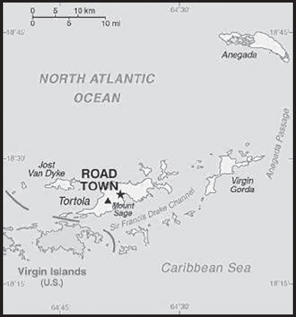
INTRODUCTION
Background: First inhabited by Arawak and later by Carib Indians, the Virgin Islands were settled by the Dutch in 1648 and then annexed by the English in 1672. The islands were part of the British colony of the Leeward Islands (1872-1960); they were granted autonomy in 1967. The economy is closely tied to the larger and more populous US Virgin Islands to the west; the US dollar is the legal currency. On 6 September 2017, Hurricane Irma devastated the island of Tortola. An estimated 80% of residential and business structures were destroyed or damaged, communications disrupted, and local roads rendered impassable.
GEOGRAPHY
Location: Caribbean, between the Caribbean Sea and the North Atlantic Ocean, east of Puerto Rico
Geographic coordinates: 18 30 N, 64 30 W
Map references: Central America and the Caribbean
Area: total: 151 sq km
land: 151 sq km
water: 0 sq km
note: comprised of 16 inhabited and more than 20 uninhabited islands; includes the islands of Tortola, Anegada, Virgin Gorda, Jost van Dyke
comparison ranking: total 219
Area - comparative: about 0.9 times the size of Washington, DC
Land boundaries: total: 0 km
Coastline: 80 km
Maritime claims: territorial sea: 12 nm
exclusive fishing zone: 200 nm
Climate: subtropical; humid; temperatures moderated by trade winds
Terrain: coral islands relatively flat; volcanic islands steep, hilly
Elevation: highest point: Mount Sage 521 m
lowest point: Caribbean Sea 0 m
Natural resources: NEGL; pleasant climate, beaches foster tourism
Land use: agricultural land: 46.7% (2018 est.)
arable land: 6.7% (2018 est.)
permanent crops: 6.7% (2018 est.)
permanent pasture: 33.3% (2018 est.)
forest: 24.3% (2018 est.)
other: 29% (2018 est.)
Irrigated land: NA
Population distribution: a fairly even distribution throughout the inhabited islands, with the largest islands of Tortola, Anegada, Virgin Gorda, and Jost Van Dyke having the largest populations
Natural hazards: hurricanes and tropical storms (July to October)
Geography - note: strong ties to nearby US Virgin Islands and Puerto Rico
PEOPLE AND SOCIETY
Population: 39,369 (2023 est.)
comparison ranking: 213
Nationality: noun: British Virgin Islander(s)
adjective: British Virgin Islander
Ethnic groups: African/Black 76.3%, Latino 5.5%, White 5.4%, mixed 5.3%, Indian 2.1%, East Indian 1.6%, other 3%, unspecified 0.8% (2010 est.)
Languages: English (official), Virgin Islands Creole
Religions: Protestant 70.2% (Methodist 17.6%, Church of God 10.4%, Anglican 9.5%, Seventh Day Adventist 9.0%, Pentecostal 8.2%, Baptist 7.4%, New Testament Church of God 6.9%, other Protestant 1.2%), Roman Catholic 8.9%, Jehovah’s Witness 2.5%, Hindu 1.9%, other 6.2%, none 7.9%, unspecified 2.4% (2010 est.)
Age structure: 0-14 years: 16.56% (male 3,231/female 3,287)
15-64 years: 71.87% (male 13,322/female 14,972)
65 years and over: 11.58% (2023 est.) (male 2,156/female 2,401)
Dependency ratios: total dependency ratio: 32.8
youth dependency ratio: 20.2
elderly dependency ratio: 12.6
potential support ratio: 8 (2021)
Median age: total: 37.2 years (2020)
male: 37 years
female: 37.5 years
comparison ranking: total 73
Population growth rate: 1.87% (2023 est.)
comparison ranking: 45
Birth rate: 10.9 births/1,000 population (2023 est.)
comparison ranking: 169
Death rate: 5.44 deaths/1,000 population (2023 est.)
comparison ranking: 184
Net migration rate: 13.21 migrant(s)/1,000 population (2023 est.)
comparison ranking: 4
Population distribution: a fairly even distribution throughout the inhabited islands, with the largest islands of Tortola, Anegada, Virgin Gorda, and Jost Van Dyke having the largest populations
Urbanization: urban population: 49.7% of total population (2023)
rate of urbanization: 1.73% annual rate of change (2020-25 est.)
Major urban areas - population: 15,000 ROAD TOWN (capital) (2018)
Sex ratio: at birth: 1.05 male(s)/female
0-14 years: 0.98 male(s)/female
15-64 years: 0.89 male(s)/female
65 years and over: 0.9 male(s)/female
total population: 0.91 male(s)/female (2023 est.)
Infant mortality rate: total: 13.77 deaths/1,000 live births (2023 est.)
male: 16.41 deaths/1,000 live births
female: 10.99 deaths/1,000 live births
comparison ranking: total 107
Life expectancy at birth: total population: 79.9 years (2023 est.)
male: 78.4 years
female: 81.47 years
comparison ranking: total population 57
Total fertility rate: 1.37 children born/woman (2023 est.)
comparison ranking: 216
Gross reproduction rate: 0.67 (2023 est.)
Drinking water source: improved: total: 99.9% of population
unimproved: total: 0.1% of population (2020 est.)
Sanitation facility access: improved: urban: 97.5% of population
rural: 97.5% of population
total: 97.5% of population
unimproved: urban: 2.5% of population
rural: 2.5% of population
total: 2.5% of population (2015 est.)
Currently married women (ages 15-49): 46.6% (2023 est.)
Education expenditures: 2.6% of GDP (2020 est.)
comparison ranking: 172
School life expectancy (primary to tertiary education): total: 12 years
male: 12 years
female: 12 years (2018)
ENVIRONMENT
Environment - current issues: limited natural freshwater resources except for a few seasonal streams and springs on Tortola; most of the islands’ water supply comes from desalination plants; sewage and mining/industry waste contribute to water pollution, threatening coral reefs
Climate: subtropical; humid; temperatures moderated by trade winds
Land use: agricultural land: 46.7% (2018 est.)
arable land: 6.7% (2018 est.)
permanent crops: 6.7% (2018 est.)
permanent pasture: 33.3% (2018 est.)
forest: 24.3% (2018 est.)
other: 29% (2018 est.)
Urbanization: urban population: 49.7% of total population (2023)
rate of urbanization: 1.73% annual rate of change (2020-25 est.)
Air pollutants: carbon dioxide emissions: 0.21 megatons (2016 est.)
Waste and recycling: municipal solid waste generated annually: 21,099 tons (2000 est.)
GOVERNMENT
Country name: conventional long form: none
conventional short form: British Virgin Islands
abbreviation: BVI
etymology: the myriad islets, cays, and rocks surrounding the major islands reminded explorer Christopher COLUMBUS in 1493 of Saint Ursula and her 11,000 virgin followers (Santa Ursula y las Once Mil Virgenes), which over time shortened to the Virgins (las Virgenes)
Government type: Overseas Territory of the UK with limited self-government; parliamentary democracy
Dependency status: overseas territory of the UK; internal self-governing
Capital: name: Road Town
geographic coordinates: 18 25 N, 64 37 W
time difference: UTC-4 (1 hour ahead of Washington, DC, during Standard Time)
etymology: name refers to the nautical term “roadstead” or “roads,” a body of water less sheltered than a harbor but where ships can lie reasonably safely at anchor sheltered from rip currents, spring tides, or ocean swells
Administrative divisions: none (overseas territory of the UK)
Independence: none (overseas territory of the UK)
National holiday: Territory Day, 1 July (1956)
Constitution: history: several previous; latest effective 15 June 2007 (The Virgin Islands Constitution Order 2007)
amendments: initiated by any elected member of the House of Assembly; passage requires simple majority vote by the elected members of the Assembly and assent by the governor on behalf of the monarch; amended 2015
Legal system: English common law
Citizenship: see United Kingdom
Suffrage: 18 years of age; universal
Executive branch: chief of state: King CHARLES III (since 8 September 2022); represented by Governor John J. RANKIN (since 29 January 2021)
head of government: Premier Dr. Natalio WHEATLEY (since 5 May 2022)
cabinet: Executive Council appointed by the governor from members of the House of Assembly
elections/appointments: the monarchy is hereditary; governor appointed by the monarch; following legislative elections, the leader of the majority party or majority coalition usually appointed premier by the governor
note: on 5 May 2022, Premier Andrew FAHIE was removed from office by a no confidence vote in House of Assembly following his arrest on drug trafficking and money laundering charges on 28 April 2022; Premier Dr. Natalio WHEATLEY sworn in as premier on 5 May 2022
Legislative branch: description: unicameral House of Assembly (15 seats; 13 members - 9 in single-seat constituencies and 4 members in a single, nationwide constituency directly elected by simple majority vote and 2 ex-officio members - the attorney general and the speaker - chosen from outside the House; members serve 4-year terms)
elections: last held on 24 April 2023 (next to be held in 2027)
election results: percent of vote by party - PVIM 34.2%, VIP 31.9%, NDP 26.1%, PU 8%; seats by party - VIP 6, NDP 3, PVIM 3, PU 1
Judicial branch: highest court(s): the Eastern Caribbean Supreme Court (ECSC) is the superior court of the Organization of Eastern Caribbean States; the ECSC - headquartered on St. Lucia - consists of the Court of Appeal - headed by the chief justice and 4 judges - and the High Court with 18 judges; the Court of Appeal is itinerant, traveling to member states on a schedule to hear appeals from the High Court and subordinate courts; High Court judges reside in the member states, with 3 in the British Virgin Islands
judge selection and term of office: Eastern Caribbean Supreme Court chief justice appointed by Her Majesty, Queen ELIZABETH II; other justices and judges appointed by the Judicial and Legal Services Commission; Court of Appeal justices appointed for life with mandatory retirement at age 65; High Court judges appointed for life with mandatory retirement at age 62
subordinate courts: Magistrates’ Courts
Political parties and leaders: National Democratic Party or NDP [Marlon PENN]
Progressive Virgin Islands Movement or PVIM [Ronnie SKELTON]
Progressives United or PU [Julian FRASER]
Virgin Islands Party or VIP [Natalio WHEATLEY]
International organization participation: Caricom (associate), CDB, Interpol (subbureau), IOC, OECS, UNESCO (associate), UPU
Diplomatic representation in the US: none (overseas territory of the UK)
Diplomatic representation from the US: embassy: none (overseas territory of the UK)
Flag description: blue with the flag of the UK in the upper hoist-side quadrant and the Virgin Islander coat of arms centered in the outer half of the flag; the coat of arms depicts a woman flanked on either side by a vertical column of six oil lamps above a scroll bearing the Latin word VIGILATE (Be Watchful); the islands were named by COLUMBUS in 1493 in honor of Saint Ursula and her 11 virgin followers (some sources say 11,000) who reputedly were martyred by the Huns in the 4th or 5th century; the figure on the banner holding a lamp represents the saint; the other lamps symbolize her followers
National symbol(s): zenaida dove, white cedar flower; national colors: yellow, green, red, white, blue
National anthem: note: as an overseas territory of the United Kingdom, “God Save the King” is official (see United Kingdom)
ECONOMY
Economic overview: British Caribbean island territorial economy; strong tourism and services industries; vulnerable to hurricanes; navigating public debt insolvency since 2008 Crisis; considered a tax haven; high electrification costs; major rum exporter
Real GDP (purchasing power parity): $500 million (2017 est.)
$490.2 million (2016 est.)
$481.1 million (2015 est.)
comparison ranking: 214
Real GDP growth rate: 2% (2017 est.)
1.9% (2016 est.)
1.8% (2015 est.)
comparison ranking: 165
Real GDP per capita: $34,200 (2017 est.)
comparison ranking: 61
GDP (official exchange rate): $1.38 billion (2018 est.)
Inflation rate (consumer prices): 4.2% (2022 est.)
2.8% (2021 est.)
0.4% (2020 est.)
comparison ranking: 84
GDP - composition, by sector of origin: agriculture: 0.2% (2017 est.)
industry: 6.8% (2017 est.)
services: 93.1% (2017 est.)
comparison rankings: services 5; industry 217; agriculture 217
GDP - composition, by end use: household consumption: 25.1% (2017 est.)
government consumption: 7.5% (2017 est.)
investment in fixed capital: 21.7% (2017 est.)
investment in inventories: 20.4% (2017 est.)
exports of goods and services: 94.7% (2017 est.)
imports of goods and services: -69.4% (2017 est.)
Agricultural products: fruits, vegetables; livestock, poultry; fish
Industries: tourism, light industry, construction, rum, concrete block, offshore banking center
Industrial production growth rate: 1.1% (2017 est.)
comparison ranking: 147
Labor force: 12,770 (2004)
comparison ranking: 215
Labor force - by occupation: agriculture: 0.6%
industry: 40%
services: 59.4% (2005)
Unemployment rate: 2.9% (2015 est.)
comparison ranking: 197
Population below poverty line: NA
Household income or consumption by percentage share: lowest 10%: NA
highest 10%: NA
Budget: revenues: $400 million (2017 est.)
expenditures: $400 million (2017 est.)
Budget surplus (+) or deficit (-): 0% (of GDP) (2017 est.)
comparison ranking: 46
Taxes and other revenues: 38.9% (of GDP) (2017 est.)
comparison ranking: 15
Fiscal year: 1 April - 31 March
Current account balance: $362.6 million (2011 est.)
$279.8 million (2010 est.)
comparison ranking: 61
Exports: $23 million (2017 est.)
$23 million (2015 est.)
note: Data are in current year dollars and do not include illicit exports or re-exports.
comparison ranking: 215
Exports - partners: Malta 30%, Seychelles 29%, Switzerland 14% (2019)
Exports - commodities: aircraft, recreational boats, ships, hydrogen, halogens (2021)
Imports: $300 million (2017 est.) NA
$210 million (2016 est.)
comparison ranking: 208
Imports - partners: Germany 32%, United States 22%, Italy 9%, France 7%, Seychelles 7% (2019)
Imports - commodities: recreational boats, aircraft, refined petroleum, cars, furniture (2019)
Debt - external: $36.1 million (1997)
comparison ranking: 198
Exchange rates: the US dollar is used
ENERGY
Electricity access: electrification - total population: 100% (2021)
Electricity: installed generating capacity: 33,000 kW (2020 est.)
consumption: 116.298 million kWh (2019 est.)
exports: 0 kWh (2020 est.)
imports: 0 kWh (2020 est.)
transmission/distribution losses: 22.5 million kWh (2019 est.)
comparison rankings: imports 148; exports 136; installed generating capacity 200; transmission/distribution losses 183; consumption 194
Electricity generation sources: fossil fuels: 98.8% of total installed capacity (2020 est.)
solar: 0.2% of total installed capacity (2020 est.)
wind: 1% of total installed capacity (2020 est.)
Petroleum: total petroleum production: 0 bbl/day (2021 est.)
refined petroleum consumption: 1,200 bbl/day (2019 est.)
Refined petroleum products - imports: 1,227 bbl/day (2015 est.)
comparison ranking: 199
Carbon dioxide emissions: 173,000 metric tonnes of CO2 (2019 est.)
from petroleum and other liquids: 173,000 metric tonnes of CO2 (2019 est.)
comparison ranking: total emissions 205
Energy consumption per capita: 80.136 million Btu/person (2019 est.)
comparison ranking: 74
COMMUNICATIONS
Telephones - fixed lines: total subscriptions: 7,000 (2021 est.)
subscriptions per 100 inhabitants: 22 (2021 est.)
comparison ranking: total subscriptions 197
Telephones - mobile cellular: total subscriptions: 35,000 (2021 est.)
subscriptions per 100 inhabitants: 110 (2021 est.)
comparison ranking: total subscriptions 210
Telecommunication systems: general assessment: the telecom sector has seen a decline in subscriber numbers (particularly for prepaid mobile services the mainstay of short term visitors) and revenue; fixed and mobile broadband services are two areas that have benefited from the crisis as employees and students have resorted to working from home; one major casualty may be the region’s second largest telco operator, Digicel; the company filed for bankruptcy in the US in April 2020; it continues to operate in all of its Caribbean markets as it seeks to refinance billions of dollars of debt; the other major telco, regional incumbent Cable & Wireless Communications (CWC), is experiencing similar drops in subscriber numbers and revenue; CWC is expanding and enhancing its fixed and mobile networks in many of the countries it serves around the Caribbean, despite many locations being small islands with very small populations; one area of the telecom market that is not prepared for growth is 5G mobile; governments, regulators, and even the mobile network operators have shown that they have not been investing in 5G opportunities at the present time; network expansion and enhancements remain concentrated around improving LTE coverage. (2021)
domestic: fixed-line connections exceed 22 per 100 persons and mobile cellular subscribership is roughly 110 per 100 persons (2021)
international: country code - 1-284; landing points for PCCS, ECFS, CBUS, Deep Blue Cable, East-West, PAN-AM, Americas-1, Southern Caribbean Fiber, Columbus- IIb, St Thomas - St Croix System, Taino-Carib, and Americas I-North via submarine cable to Caribbean, Central and South America, and US (2019)
Broadcast media: 1 private TV station; multi-channel TV is available from cable and satellite subscription services; about a half-dozen private radio stations
Internet country code: .vg
Internet users: total: 24,087 (2021 est.)
percent of population: 77.7% (2021 est.)
comparison ranking: total 211
Broadband - fixed subscriptions: total: 6,738 (2020 est.)
subscriptions per 100 inhabitants: 22 (2020 est.)
comparison ranking: total 182
TRANSPORTATION
Civil aircraft registration country code prefix: VP-L
Airports: 4 (2021)
comparison ranking: total 189
Airports - with paved runways: 2
note: paved runways have a concrete or asphalt surface but not all have facilities for refueling, maintenance, or air traffic control; the length of a runway required for aircraft to safely operate depends on a number of factors including the type of aircraft, the takeoff weight (including passengers, cargo, and fuel), engine types, flap settings, landing speed, elevation of the airport, and average maximum daily air temperature; paved runways can reach a length of 5,000 m (16,000 ft.), but the “typical” length of a commercial airline runway is between 2,500-4,000 m (8,000-13,000 ft.)
Airports - with unpaved runways: 2
note: unpaved runways have a surface composition such as grass or packed earth and are most suited to the operation of light aircraft; unpaved runways are usually short, often less than 1,000 m (3,280 ft.) in length; airports with unpaved runways often lack facilities for refueling, maintenance, or air traffic control
Roadways: total: 200 km (2007)
paved: 200 km (2007)
comparison ranking: total 207
Merchant marine: total: 30 (2022)
by type: general cargo 3, other 27
comparison ranking: total 136
Ports and terminals: major seaport(s): Road Harbor
cruise port(s): Tortola
MILITARY AND SECURITY
Military - note: defense is the responsibility of the UK
TRANSNATIONAL ISSUES
Disputes - international: none
Illicit drugs: transshipment point for South American narcotics destined for the US and Europe; large offshore financial center makes it vulnerable to money laundering
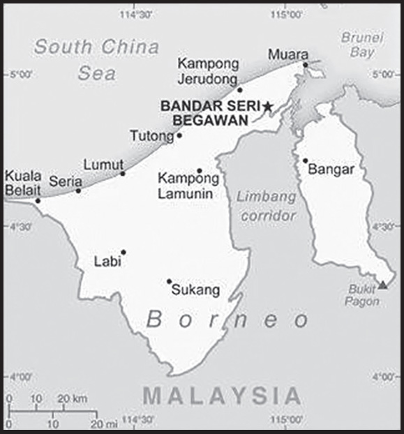
INTRODUCTION
Background: The Sultanate of Brunei’s influence peaked between the 15th and 17th centuries when its control extended over coastal areas of northwest Borneo and the southern Philippines. Brunei subsequently entered a period of decline brought on by internal strife over royal succession, colonial expansion of European powers, and piracy. In 1888, Brunei became a British protectorate; independence was achieved in 1984. The same family has ruled Brunei for over six centuries. Brunei benefits from extensive petroleum and natural gas fields, the source of one of the highest per capita GDPs in the world. In 2017, Brunei celebrated the 50th anniversary of the Sultan Hassanal BOLKIAH’s accession to the throne.
GEOGRAPHY
Location: Southeastern Asia, along the northern coast of the island of Borneo, bordering the South China Sea and Malaysia
Geographic coordinates: 4 30 N, 114 40 E
Map references: Southeast Asia
Area: total: 5,765 sq km
land: 5,265 sq km
water: 500 sq km
comparison ranking: total 172
Area - comparative: slightly smaller than Delaware
Land boundaries: total: 266 km
border countries (1): Malaysia 266 km
Coastline: 161 km
Maritime claims: territorial sea: 12 nm
exclusive economic zone: 200 nm or to median line
Climate: tropical; hot, humid, rainy
Terrain: flat coastal plain rises to mountains in east; hilly lowland in west
Elevation: highest point: Bukit Pagon 1,850 m
lowest point: South China Sea 0 m
mean elevation: 478 m
Natural resources: petroleum, natural gas, timber
Land use: agricultural land: 2.5% (2018 est.)
arable land: 0.8% (2018 est.)
permanent crops: 1.1% (2018 est.)
permanent pasture: 0.6% (2018 est.)
forest: 71.8% (2018 est.)
other: 25.7% (2018 est.)
Irrigated land: 10 sq km (2012)
Population distribution: the vast majority of the population is found along the coast in the western part of Brunei, which is separated from the eastern portion by Malaysia; the largest population concentration is in the far north on the western side of the Brunei Bay, in and around the capital of Bandar Seri Begawan
Natural hazards: typhoons, earthquakes, and severe flooding are rare
Geography - note: close to vital sea lanes through South China Sea linking Indian and Pacific Oceans; two parts physically separated by Malaysia; the eastern part, the Temburong district, is an exclave and is almost an enclave within Malaysia
PEOPLE AND SOCIETY
Population: 484,991 (2023 est.)
note: immigrants make up approximately 26% of the total population, according to UN data (2019)
comparison ranking: 173
Nationality: noun: Bruneian(s)
adjective: Bruneian
Ethnic groups: Malay 67.4%, Chinese 9.6%, other 23% (2021 est.)
Languages: Malay (Bahasa Melayu) (official), English, Chinese dialects
major-language sample(s): Buku Fakta Dunia, sumber yang diperlukan untuk maklumat asas. (Malay)
Religions: Muslim (official) 82.1%, Christian 6.7%, Buddhist 6.3%, other 4.9% (2021 est.)
Demographic profile: Brunei is a small, oil-rich sultanate of less than half a million people, making it the smallest country in Southeast Asia by population. Its total fertility rate – the average number of births per woman – has been steadily declining over the last few decades, from over 3.5 in the 1980s to below replacement level today at nearly 1.8. The trend is due to women’s increased years of education and participation in the workforce, which have resulted in later marriages and fewer children. Yet, the population continues to grow because of the large number of women of reproductive age and a reliance on foreign labor – mainly from Malaysia, Thailand, the Philippines, Indonesia, and South Asian countries – to fill low-skilled jobs.
Brunei is officially Muslim, and Malay is the official language. The country follows an official Malay national ideology, Malay Islamic Monarchy, which promotes Malay language and culture, Islamic values, and the monarchy. Only seven of Brunei’s native groups are recognized in the constitution and are defined as “Malay” – Brunei Malays, Belait, Kedayan, Dusun, Bisayak, Lun Bawang, and Sama-Baiau. Together they make up about 66% percent of the population and are referred to as the Bumiputera. The Bumiputera are entitled to official privileges, including land ownership, access to certain types of employment (Royal Brunei Armed Forces and Brunei Shell Petroleum), easier access to higher education, and better job opportunities in the civil service.
Brunei’s Chinese population descends from migrants who arrived when Brunei was a British protectorate (1888 and 1984). They are prominent in the non-state commercial sector and account for approximately 10% of the population. Most Bruneian Chinese are permanent residents rather than citizens despite roots going back several generations. Many are stateless and are denied rights granted to citizens, such as land ownership, subsidized health care, and free secondary and university education. Because of the discriminatory policies, the number of Chinese in Brunei has shrunk considerably in the last 50 years. Native ethnic groups that are not included in the Bumiputera are not recognized in the constitution and are not officially identified as “Malay” or automatically granted citizenship. Foreign workers constitute some quarter of the labor force.
Age structure: 0-14 years: 21.83% (male 54,523/female 51,334)
15-64 years: 71.07% (male 164,957/female 179,721)
65 years and over: 7.1% (2023 est.) (male 16,748/female 17,708)
Dependency ratios: total dependency ratio: 39.2
youth dependency ratio: 31.1
elderly dependency ratio: 8.1
potential support ratio: 12.4 (2021 est.)
Median age: total: 31.1 years (2020)
male: 30.5 years
female: 31.8 years
comparison ranking: total 116
Population growth rate: 1.43% (2023 est.)
comparison ranking: 67
Birth rate: 15.98 births/1,000 population (2023 est.)
comparison ranking: 101
Death rate: 3.85 deaths/1,000 population (2023 est.)
comparison ranking: 218
Net migration rate: 2.15 migrant(s)/1,000 population (2023 est.)
comparison ranking: 47
Population distribution: the vast majority of the population is found along the coast in the western part of Brunei, which is separated from the eastern portion by Malaysia; the largest population concentration is in the far north on the western side of the Brunei Bay, in and around the capital of Bandar Seri Begawan
Urbanization: urban population: 79.1% of total population (2023)
rate of urbanization: 1.44% annual rate of change (2020-25 est.)
Major urban areas - population: 266,682 BANDAR SERI BEGAWAN (capital) (2021)
note: the boundaries of the capital city were expanded in 2007, greatly increasing the city area; the population of the capital increased tenfold
Sex ratio: at birth: 1.05 male(s)/female
0-14 years: 1.06 male(s)/female
15-64 years: 0.92 male(s)/female
65 years and over: 0.95 male(s)/female
total population: 0.95 male(s)/female (2023 est.)
Maternal mortality ratio: 44 deaths/100,000 live births (2020 est.)
comparison ranking: 99
Infant mortality rate: total: 10.26 deaths/1,000 live births (2023 est.)
male: 12.55 deaths/1,000 live births
female: 7.86 deaths/1,000 live births
comparison ranking: total 134
Life expectancy at birth: total population: 78.61 years (2023 est.)
male: 76.26 years
female: 81.08 years
comparison ranking: total population 72
Total fertility rate: 1.74 children born/woman (2023 est.)
comparison ranking: 155
Gross reproduction rate: 0.85 (2023 est.)
Drinking water source: improved: urban: 99.7% of population
total: 99.9% of population
unimproved: urban: 0.4% of population
total: 0.1% of population (2020)
Current health expenditure: 2.4% of GDP (2020)
Physicians density: 1.61 physicians/1,000 population (2017)
Hospital bed density: 2.9 beds/1,000 population (2017)
Obesity - adult prevalence rate: 14.1% (2016)
comparison ranking: 129
Alcohol consumption per capita: total: 0.69 liters of pure alcohol (2019 est.)
beer: 0.66 liters of pure alcohol (2019 est.)
wine: 0.04 liters of pure alcohol (2019 est.)
spirits: 0 liters of pure alcohol (2019 est.)
other alcohols: 0 liters of pure alcohol (2019 est.)
comparison ranking: total 157
Tobacco use: total: 16.2% (2020 est.)
male: 30% (2020 est.)
female: 2.3% (2020 est.)
comparison ranking: total 100
Currently married women (ages 15-49): 54.3% (2023 est.)
Education expenditures: 4.4% of GDP (2016 est.)
comparison ranking: 104
Literacy: definition: age 15 and over can read and write
total population: 97.6%
male: 98.3%
female: 96.9% (2021)
School life expectancy (primary to tertiary education): total: 14 years
male: 14 years
female: 14 years (2020)
Youth unemployment rate (ages 15-24): total: 23.4% (2021 est.)
male: 20.7%
female: 27.6%
comparison ranking: total 68
ENVIRONMENT
Environment - current issues: no major environmental problems, but air pollution control is becoming a concern; seasonal trans-boundary haze from forest fires in Indonesia
Environment - international agreements: party to: Biodiversity, Climate Change, Climate Change-Kyoto Protocol, Climate Change-Paris Agreement, Comprehensive Nuclear Test Ban, Desertification, Endangered Species, Hazardous Wastes, Law of the Sea, Ozone Layer Protection, Ship Pollution
signed, but not ratified: none of the selected agreements
Climate: tropical; hot, humid, rainy
Land use: agricultural land: 2.5% (2018 est.)
arable land: 0.8% (2018 est.)
permanent crops: 1.1% (2018 est.)
permanent pasture: 0.6% (2018 est.)
forest: 71.8% (2018 est.)
other: 25.7% (2018 est.)
Urbanization: urban population: 79.1% of total population (2023)
rate of urbanization: 1.44% annual rate of change (2020-25 est.)
Revenue from forest resources: 0.05% of GDP (2018 est.)
comparison ranking: 129
Revenue from coal: 0% of GDP (2018 est.)
comparison ranking: 106
Air pollutants: particulate matter emissions: 6.86 micrograms per cubic meter (2019 est.)
carbon dioxide emissions: 7.66 megatons (2016 est.)
methane emissions: 8.4 megatons (2020 est.)
Waste and recycling: municipal solid waste generated annually: 216,253 tons (2016 est.)
Total water withdrawal: municipal: 150 million cubic meters (2020 est.)
agricultural: 10 million cubic meters (2020 est.)
Total renewable water resources: 8.5 billion cubic meters (2020 est.)
GOVERNMENT
Country name: conventional long form: Brunei Darussalam
conventional short form: Brunei
local long form: Negara Brunei Darussalam
local short form: Brunei
etymology: derivation of the name is unclear; according to legend, MUHAMMAD SHAH, who would become the first sultan of Brunei, upon discovering what would become Brunei exclaimed “Baru nah,” which roughly translates as “there” or “that’s it”
Government type: absolute monarchy or sultanate
Capital: name: Bandar Seri Begawan
geographic coordinates: 4 53 N, 114 56 E
time difference: UTC+8 (13 hours ahead of Washington, DC, during Standard Time)
etymology: named in 1970 after Sultan Omar Ali SAIFUDDIEN III (1914-1986; “The Father of Independence”) who adopted the title of “Seri Begawan” (approximate meaning “honored lord”) upon his abdication in 1967; “bandar” in Malay means “town” or “city”; the capital had previously been called Bandar Brunei (Brunei Town)
Administrative divisions: 4 districts (daerah-daerah, singular - daerah); Belait, Brunei dan Muara, Temburong, Tutong
Independence: 1 January 1984 (from the UK)
National holiday: National Day, 23 February (1984); note - 1 January 1984 was the date of independence from the UK, 23 February 1984 was the date of independence from British protection; the Sultan’s birthday, 15 June
Constitution: history: drafted 1954 to 1959, signed 29 September 1959; note - some constitutional provisions suspended since 1962 under a State of Emergency, others suspended since independence in 1984
amendments: proposed by the monarch; passage requires submission to the Privy Council for Legislative Council review and finalization takes place by proclamation; the monarch can accept or reject changes to the original proposal provided by the Legislative Council; amended several times, last in 2010
Legal system: mixed legal system based on English common law and Islamic law; note - in April 2019, the full sharia penal codes came into force and apply to Muslims and partly to non-Muslims in parallel with present common law codes
International law organization participation: has not submitted an ICJ jurisdiction declaration; non-party state to the ICC
Citizenship: citizenship by birth: no
citizenship by descent only: the father must be a citizen of Brunei
dual citizenship recognized: no
residency requirement for naturalization: 12 years
Suffrage: 18 years of age for village elections; universal
Executive branch: chief of state: Sultan and Prime Minister Sir HASSANAL Bolkiah (since 5 October 1967); note - the monarch is both chief of state and head of government
head of government: Sultan and Prime Minister Sir HASSANAL Bolkiah (since 5 October 1967)
cabinet: Council of Ministers appointed and presided over by the monarch; note - 4 additional advisory councils appointed by the monarch are the Religious Council, Privy Council for constitutional issues, Council of Succession, and Legislative Council; Sultan and Prime Minister Sir HASSANAL Bolkiah is also Minister of Finance, Defense, and Foreign Affairs and Trade
elections/appointments: none; the monarchy is hereditary
Legislative branch: description: unicameral Legislative Council or Majlis Mesyuarat Negara Brunei (33 seats; 20 members appointed by the sultan from ex-officio cabinet ministers, titled people, and prominent citizens in public service and various professional fields, 13 members from 4 multi-seat constituencies, and 3 ex-officio members - the speaker and first and second secretaries); members serve 5-year terms
elections: January 2017 - appointed by the sultan
election results: Legislative Council last appointed January 2023; composition men 30, women 4, percent of women 11.8%
Judicial branch: highest court(s): Supreme Court (consists of the Court of Appeal and the High Court, each with a chief justice and 2 judges); Sharia Court (consists the Court of Appeals and the High Court); note - Brunei has a dual judicial system of secular and sharia (religious) courts; the Judicial Committee of Privy Council (in London) serves as the final appellate court for civil cases only
judge selection and term of office: Supreme Court judges appointed by the monarch to serve until age 65, and older if approved by the monarch; Sharia Court judges appointed by the monarch for life
subordinate courts: Intermediate Court; Magistrates’ Courts; Juvenile Court; small claims courts; lower sharia courts
Political parties and leaders: National Development Party or NDP [Zainal Talib]
note: the NDP is Brunei’s only registered party, but does not have representation in the Legislative Council, which is appointed
International organization participation: ADB, APEC, ARF, ASEAN, C, CP, EAS, FAO, G-77, IAEA, IBRD, ICAO, ICC (NGOs), ICRM, IDA, IFRCS, ILO, IMF, IMO, IMSO, Interpol, IOC, ISO (correspondent), ITSO, ITU, NAM, OIC, OPCW, UN, UNCTAD, UNESCO, UNIFIL, UNWTO, UPU, WCO, WHO, WIPO, WMO, WTO
Diplomatic representation in the US: chief of mission: Ambassador Dato Paduka Haji Serbini bin Haji ALI (since 28 January 2016)
chancery: 3520 International Court NW, Washington, DC 20008
telephone: [1] (202) 237-1838
FAX: [1] (202) 885-0560
email address and website:
http://www.bruneiembassy.org/index.html
consulate(s): New York
Diplomatic representation from the US: chief of mission: Ambassador Caryn R. McCLELLAND (since December 2021)
embassy: Simpang 336-52-16-9, Jalan Duta, Bandar Seri Begawan, BC4115
mailing address: 4020 Bandar Seri Begawan Place, Washington DC 20521-4020
telephone: (673) 238-7400
FAX: (673) 238-7533
email address and website:
Flag description: yellow with two diagonal bands of white (top, almost double width) and black starting from the upper hoist side; the national emblem in red is superimposed at the center; yellow is the color of royalty and symbolizes the sultanate; the white and black bands denote Brunei’s chief ministers; the emblem includes five main components: a swallow-tailed flag, the royal umbrella representing the monarchy, the wings of four feathers symbolizing justice, tranquility, prosperity, and peace, the two upraised hands signifying the government’s pledge to preserve and promote the welfare of the people, and the crescent moon denoting Islam, the state religion; the state motto “Always render service with God’s guidance” appears in yellow Arabic script on the crescent; a ribbon below the crescent reads “Brunei, the Abode of Peace”
National symbol(s): royal parasol; national colors: yellow, white, black
National anthem: name: “Allah Peliharakan Sultan” (God Bless His Majesty)
lyrics/music: Pengiran Haji Mohamed YUSUF bin Pengiran Abdul Rahim/Awang Haji BESAR bin Sagap
note: adopted 1951
ECONOMY
Economic overview: almost exclusively an oil and gas economy; high income country; expansive and robust welfare system; the majority of the population works for the government; promulgating a nationalized halal brand; considering establishment of a bond market and stock exchange
Real GDP (purchasing power parity): $26.779 billion (2021 est.)
$27.212 billion (2020 est.)
$26.907 billion (2019 est.)
note: data are in 2017 dollars
comparison ranking: 144
Real GDP growth rate: -1.59% (2021 est.)
1.13% (2020 est.)
3.87% (2019 est.)
comparison ranking: 201
Real GDP per capita: $60,100 (2021 est.)
$61,600 (2020 est.)
$61,400 (2019 est.)
note: data are in 2017 dollars
comparison ranking: 17
GDP (official exchange rate): $12.13 billion (2017 est.)
Inflation rate (consumer prices): 1.73% (2021 est.)
1.94% (2020 est.)
-0.39% (2019 est.)
comparison ranking: 169
GDP - composition, by sector of origin: agriculture: 1.2% (2017 est.)
industry: 56.6% (2017 est.)
services: 42.3% (2017 est.)
comparison rankings: services 204; industry 5; agriculture 193
GDP - composition, by end use: household consumption: 25% (2017 est.)
government consumption: 24.8% (2017 est.)
investment in fixed capital: 32.6% (2017 est.)
investment in inventories: 8.5% (2017 est.)
exports of goods and services: 45.9% (2017 est.)
imports of goods and services: -36.8% (2017 est.)
Agricultural products: poultry, eggs, fruit, cassava, bananas, legumes, cucumbers, rice, pineapples, beef
Industries: petroleum, petroleum refining, liquefied natural gas, construction, agriculture, aquaculture, transportation
Industrial production growth rate: -4.17% (2021 est.)
comparison ranking: 185
Labor force: 219,800 (2021 est.)
comparison ranking: 176
Labor force - by occupation: agriculture: 4.2%
industry: 62.8%
services: 33% (2008 est.)
Unemployment rate: 7.65% (2021 est.)
7.68% (2020 est.)
6.92% (2019 est.)
comparison ranking: 101
Youth unemployment rate (ages 15-24): total: 23.4% (2021 est.)
male: 20.7%
female: 27.6%
comparison ranking: total 68
Budget: revenues: $1.058 billion (2020 est.)
expenditures: $3.189 billion (2020 est.)
Budget surplus (+) or deficit (-): -17.3% (of GDP) (2017 est.)
comparison ranking: 218
Public debt: 2.8% of GDP (2017 est.)
3% of GDP (2016 est.)
comparison ranking: 207
Taxes and other revenues: 18.5% (of GDP) (2017 est.)
comparison ranking: 105
Fiscal year: 1 April - 31 March
Current account balance: $1.57 billion (2021 est.)
$513.713 million (2020 est.)
$893.759 million (2019 est.)
comparison ranking: 47
Exports: $11.202 billion (2021 est.)
$6.886 billion (2020 est.)
$7.828 billion (2019 est.)
note: Data are in current year dollars and do not include illicit exports or re-exports.
comparison ranking: 100
Exports - partners: Singapore 21%, China 20%, Japan 19%, Australia 14%, Malaysia 5% (2021)
Exports - commodities: refined petroleum, natural gas, crude petroleum, industrial hydrocarbons, industrial alcohols (2021)
Imports: $9.219 billion (2021 est.) note: data are in current year dollars
$6.382 billion (2020 est.) note: data are in current year dollars
$6.806 billion (2019 est.)
comparison ranking: 118
Imports - partners: Singapore 18%, China 14%, Malaysia 12%, Nigeria 5%, United Arab Emirates 5%, United States 5% (2019)
Imports - commodities: crude petroleum, refined petroleum, cars, tug boats, valves (2019)
Reserves of foreign exchange and gold: $3.997 billion (31 December 2020 est.)
$4.273 billion (31 December 2019 est.)
$3.407 billion (31 December 2018 est.)
comparison ranking: 110
Debt - external: $0 (2014)
$0 (2013)
note: public external debt only; private external debt unavailable
comparison ranking: 206
Exchange rates: Bruneian dollars (BND) per US dollar -
Exchange rates: 1.344 (2021 est.)
1.38 (2020 est.)
1.364 (2019 est.)
1.349 (2018 est.)
1.381 (2017 est.)
ENERGY
Electricity access: electrification - total population: 100% (2021)
Electricity: installed generating capacity: 1.261 million kW (2020 est.)
consumption: 4,140,140,000 kWh (2019 est.)
exports: 0 kWh (2019 est.)
imports: 0 kWh (2019 est.)
transmission/distribution losses: 497 million kWh (2019 est.)
comparison rankings: installed generating capacity 130; transmission/distribution losses 130; imports 140; exports 123; consumption 132
Electricity generation sources: fossil fuels: 100% of total installed capacity (2020 est.)
solar: 0.1% of total installed capacity (2020 est.)
Petroleum: total petroleum production: 107,300 bbl/day (2021 est.)
refined petroleum consumption: 18,800 bbl/day (2019 est.)
crude oil and lease condensate exports: 103,100 bbl/day (2018 est.)
crude oil and lease condensate imports: 0 bbl/day (2018 est.)
crude oil estimated reserves: 1.1 billion barrels (2021 est.)
Refined petroleum products - production: 10,310 bbl/day (2015 est.)
comparison ranking: 100
Refined petroleum products - exports: 0 bbl/day (2015 est.)
comparison ranking: 132
Refined petroleum products - imports: 6,948 bbl/day (2015 est.)
comparison ranking: 159
Natural gas: production: 12,498,299,000 cubic meters (2020 est.)
consumption: 4,166,987,000 cubic meters (2020 est.)
exports: 7,774,406,000 cubic meters (2020 est.)
imports: 0 cubic meters (2021 est.)
proven reserves: 260.515 billion cubic meters (2021 est.)
Carbon dioxide emissions: 9.956 million metric tonnes of CO2 (2019 est.)
from coal and metallurgical coke: 0 metric tonnes of CO2 (2019 est.)
from petroleum and other liquids: 2.387 million metric tonnes of CO2 (2019 est.)
from consumed natural gas: 7.569 million metric tonnes of CO2 (2019 est.)
comparison ranking: total emissions 107
Energy consumption per capita: 415.184 million Btu/person (2019 est.)
comparison ranking: 5
COMMUNICATIONS
Telephones - fixed lines: total subscriptions: 112,298 (2021 est.)
subscriptions per 100 inhabitants: 25 (2021 est.)
comparison ranking: total subscriptions 133
Telephones - mobile cellular: total subscriptions: 603,486 (2021 est.)
subscriptions per 100 inhabitants: 136 (2021 est.)
comparison ranking: total subscriptions 172
Telecommunication systems: general assessment: Brunei’s mobile market experienced drop-off in subscriber numbers in 2020; in 2022 there was a concerted effort to build out the fixed-line infrastructure while progressing towards introducing 5G mobile services; Brunei’s fixed-line market is one of the few countries in the world to have displayed significant growth rather than a decline in teledensity in the last few years; this upward trend is set to continue as the new Unified National Network (UNN) works diligently to expand and enhance the fixed-line infrastructure around the country; strong growth was also seen in the fixed broadband space, on the back of those same infrastructure developments that are part of the Brunei Vision 2035 initiative; fixed broadband is starting from a relatively low base by international standards and is still only at 18%, leaving lots of room for growth; mobile and mobile broadband, on the other hand, are still suffering from the market contractions first felt in 2020; Brunei’s 2G GSM network is shut down, with the spectrum to be reallocated to 3G, 4G, and potentially 5G use (2021)
domestic: 25 per 100 fixed-line, 136 per 100 mobile-cellular (2021)
international: country code - 673; landing points for the SEA-ME-WE-3, SJC, AAG, Lubuan-Brunei Submarine Cable via optical telecommunications submarine cables that provides links to Asia, the Middle East, Southeast Asia, Africa, Australia, and the US; satellite earth stations - 2 Intelsat (1 Indian Ocean and 1 Pacific Ocean) (2019)
Broadcast media: state-controlled Radio Television Brunei (RTB) operates 5 channels; 3 Malaysian TV stations are available; foreign TV broadcasts are available via satellite systems; RTB operates 5 radio networks and broadcasts on multiple frequencies; British Forces Broadcast Service (BFBS) provides radio broadcasts on 2 FM stations; some radio broadcast stations from Malaysia are available via repeaters
Internet country code: .bn
Internet users: total: 441,000 (2021 est.)
percent of population: 98% (2021 est.)
comparison ranking: total 170
Broadband - fixed subscriptions: total: 71,078 (2020 est.)
subscriptions per 100 inhabitants: 16 (2020 est.)
comparison ranking: total 134
TRANSPORTATION
National air transport system: number of registered air carriers: 1 (2020)
inventory of registered aircraft operated by air carriers: 10
annual passenger traffic on registered air carriers: 1,234,455 (2018)
annual freight traffic on registered air carriers: 129.35 million (2018) mt-km
Civil aircraft registration country code prefix: V8
Airports: 1 (2021)
comparison ranking: total 216
Airports - with paved runways: 1
note: paved runways have a concrete or asphalt surface but not all have facilities for refueling, maintenance, or air traffic control; the length of a runway required for aircraft to safely operate depends on a number of factors including the type of aircraft, the takeoff weight (including passengers, cargo, and fuel), engine types, flap settings, landing speed, elevation of the airport, and average maximum daily air temperature; paved runways can reach a length of 5,000 m (16,000 ft.), but the “typical” length of a commercial airline runway is between 2,500-4,000 m (8,000-13,000 ft.)
Heliports: 3 (2021)
Pipelines: 33 km condensate, 86 km condensate/gas, 628 km gas, 492 km oil (2013)
Roadways: total: 2,976 km (2014)
paved: 2,559 km (2014)
unpaved: 417 km (2014)
comparison ranking: total 163
Waterways: 209 km (2012) (navigable by craft drawing less than 1.2 m; the Belait, Brunei, and Tutong Rivers are major transport links)
comparison ranking: 106
Merchant marine: total: 98 (2022)
by type: general cargo 18, oil tanker 3, other 77
comparison ranking: total 91
Ports and terminals: major seaport(s): Muara
oil terminal(s): Lumut, Seria
LNG terminal(s) (export): Lumut
MILITARY AND SECURITY
Military and security forces: Royal Brunei Armed Forces: Land Force, Navy, Air Force, Joint Force
Ministry of Home Affairs: Royal Brunei Police Force (2023)
note: the Gurkha Reserve Unit (GRU) under the Ministry of Defense is a special guard force for the Sultan, the royal family, and the country’s oil installations
Military expenditures: 2.5% of GDP (2022)
3.1% of GDP (2021 est.)
3.7% of GDP (2020 est.)
3.1% of GDP (2019 est.)
2.7% of GDP (2018 est.)
comparison ranking: 38
Military and security service personnel strengths: approximately 7,000 total active-duty troops (2023)
Military equipment inventories and acquisitions: the military’s s inventory includes equipment and weapons systems from a wide variety of suppliers from Asia, Europe, and the US (2023)
Military service age and obligation: 17 years of age for voluntary military service; non-Malays are ineligible to serve (2023)
note: the Gurkha Reserve Unit (GRU) employs about 500 Gurkhas from Nepal, the majority of whom are veterans of the British Army and the Singapore Police Force who have joined the GRU as a second career
Military - note: the Royal Brunei Armed Forces were formed in 1961 with British support as the Brunei Malay Regiment; “Royal” was added as an honorary title in 1965 and its current name was given in 1984; the military is a small and professional force responsible for ensuring the country’s sovereignty and territorial integrity, as well as countering outside aggression, terrorism, and insurgency; the Army is comprised of a few infantry battalions and an armored reconnaissance squadron, while the Navy has several corvettes and patrol vessels for monitoring the country’s territorial waters; the small Air Force does not have any combat aircraft, but operates some maritime patrol aircraft and helicopters
Brunei has a long-standing defense relationship with the United Kingdom and hosts a British Army garrison, which includes a Gurkha battalion and a jungle warfare school; Brunei also hosts a Singaporean military training base (2023)
TRANSNATIONAL ISSUES
Disputes - international: per Letters of Exchange signed in 2009, Malaysia in 2010 ceded two hydrocarbon concession blocks to Brunei in exchange for Brunei’s sultan dropping claims to the Limbang corridor, which divides Brunei; nonetheless, Brunei claims a maritime boundary extending as far as a median with Vietnam, thus asserting an implicit claim to Louisa Reef
Refugees and internally displaced persons: stateless persons: 20,863 (2022); note - thousands of stateless persons, often ethnic Chinese, are permanent residents and their families have lived in Brunei for generations; obtaining citizenship is difficult and requires individuals to pass rigorous tests on Malay culture, customs, and language; stateless residents receive an International Certificate of Identity, which enables them to travel overseas; the government is considering changing the law prohibiting non-Bruneians, including stateless permanent residents, from owning land
Trafficking in persons: tier rating: Tier 2 Watch List — Brunei does not fully meet the minimum standards for the elimination of trafficking but is making significant efforts to do so, therefore Brunei was upgraded to Tier 2 Watch List; key achievements included referring two alleged traffickers for prosecution, including one Bruneian national, identifying and providing assistance to 14 victims, opening two shelters for victims, and signing a bilateral Memorandum of Understanding with Bangladesh on recruitment of migrant workers; however, the government did not effectively screen for trafficking among foreign nationals in commercial sex and migrant workers; officials handled some potential trafficking cases administratively, if at all, and probably inappropriately detained, prosecuted, and deported potentially unidentified sex and labor trafficking victims; for the sixth consecutive year, the government did not convict any traffickers under its anti-trafficking law, and other laws that could be used to prosecute traffickers did not provide sufficiently stringent sentences (2023)
trafficking profile: human traffickers exploit foreign victims in Brunei; some men and women who migrate to Brunei to work in domestic service, retail, or construction work are subject to involuntary servitude, debt-based coercion, contract switching, non-payment of wages, passport confiscation, physical abuse, or confinement; some female migrants entering Brunei on tourist visas are forced into prostitution, and some Kenyan women reportedly faced forced labor in Brunei; workers from Bangladesh and China may have been forced to work in Brunei at Chinese-run projects; some traffickers use Brunei as a transit point for victims used for sex and labor trafficking in Malaysia and Indonesia; Anti-LGBTQI+ laws place some LGBTQI+ individuals at higher risk; trafficking experts in Brunei have received threats from traffickers (2023)
Illicit drugs: drug trafficking and illegally importing controlled substances are serious offenses in Brunei and carry a mandatory death penalty