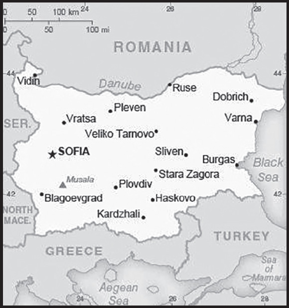
INTRODUCTION
Background: The Bulgars, a Central Asian Turkic tribe, merged with the local Slavic inhabitants in the late 7th century to form the first Bulgarian state. In succeeding centuries, Bulgaria struggled with the Byzantine Empire to assert its place in the Balkans, but by the end of the 14th century the country was overrun by the Ottoman Turks. Northern Bulgaria attained autonomy in 1878 and all of Bulgaria became independent from the Ottoman Empire in 1908. Having fought on the losing side in both World Wars, Bulgaria fell within the Soviet sphere of influence and became a People’s Republic in 1946. Communist domination ended in 1990, when Bulgaria held its first multiparty election since World War II and began the contentious process of moving toward political democracy and a market economy while combating inflation, unemployment, corruption, and crime. The country joined NATO in 2004 and the EU in 2007.
GEOGRAPHY
Location: Southeastern Europe, bordering the Black Sea, between Romania and Turkey
Geographic coordinates: 43 00 N, 25 00 E
Map references: Europe
Area: total: 110,879 sq km
land: 108,489 sq km
water: 2,390 sq km
comparison ranking: total 105
Area - comparative: almost identical in size to Virginia; slightly larger than Tennessee
Land boundaries: total: 1,806 km
border countries (5): Greece 472 km; Macedonia 162 km; Romania 605 km; Serbia 344 km; Turkey 223 km
Coastline: 354 km
Maritime claims: territorial sea: 12 nm
contiguous zone: 24 nm
exclusive economic zone: 200 nm
Climate: temperate; cold, damp winters; hot, dry summers
Terrain: mostly mountains with lowlands in north and southeast
Elevation: highest point: Musala 2,925 m
lowest point: Black Sea 0 m
mean elevation: 472 m
Natural resources: bauxite, copper, lead, zinc, coal, timber, arable land
Land use: agricultural land: 46.9% (2018 est.)
arable land: 29.9% (2018 est.)
permanent crops: 1.5% (2018 est.)
permanent pasture: 15.5% (2018 est.)
forest: 36.7% (2018 est.)
other: 16.4% (2018 est.)
Irrigated land: 987 sq km (2013)
Major rivers (by length in km): Dunav (Danube) (shared with Germany [s], Austria, Slovakia, Czechia, Hungary, Croatia, Serbia, Ukraine, Moldova, and Romania [m]) - 2,888 km
note – [s] after country name indicates river source; [m] after country name indicates river mouth
Major watersheds (area sq km): Atlantic Ocean drainage: (Black Sea) Danube (795,656 sq km)
Population distribution: a fairly even distribution throughout most of the country, with urban areas attracting larger populations
Natural hazards: earthquakes; landslides
Geography - note: strategic location near Turkish Straits; controls key land routes from Europe to Middle East and Asia
PEOPLE AND SOCIETY
Population: 6,827,736 (2023 est.)
comparison ranking: 107
Nationality: noun: Bulgarian(s)
adjective: Bulgarian
Ethnic groups: Bulgarian 76.9%, Turkish 8%, Romani 4.4%, other 0.7% (including Russian, Armenian, and Vlach), other (unknown) 10% (2011 est.)
note: Romani populations are usually underestimated in official statistics and may represent 9–11% of Bulgaria’s population
Languages: Bulgarian (official) 76.8%, Turkish 8.2%, Romani 3.8%, other 0.7%, unspecified 10.5% (2011 est.)
major-language sample(s):

(Bulgarian)
Religions: Eastern Orthodox 59.4%, Muslim 7.8%, other (including Catholic, Protestant, Armenian Apostolic Orthodox, and Jewish) 1.7%, none 3.7%, unspecified 27.4% (2011 est.)
Age structure: 0-14 years: 14.03% (male 492,147/female 465,612)
15-64 years: 65.17% (male 2,263,479/female 2,185,969)
65 years and over: 20.81% (2023 est.) (male 570,425/female 850,104)
Dependency ratios: total dependency ratio: 57.3
youth dependency ratio: 22
elderly dependency ratio: 35.3
potential support ratio: 2.8 (2021 est.)
Median age: total: 43.7 years (2020)
male: 41.9 years
female: 45.6 years
comparison ranking: total 21
Population growth rate: -0.66% (2023 est.)
comparison ranking: 226
Birth rate: 7.97 births/1,000 population (2023 est.)
comparison ranking: 217
Death rate: 14.31 deaths/1,000 population (2023 est.)
comparison ranking: 5
Net migration rate: -0.29 migrant(s)/1,000 population (2023 est.)
comparison ranking: 117
Population distribution: a fairly even distribution throughout most of the country, with urban areas attracting larger populations
Urbanization: urban population: 76.7% of total population (2023)
rate of urbanization: -0.28% annual rate of change (2020-25 est.)
Major urban areas - population: 1.288 million SOFIA (capital) (2023)
Sex ratio: at birth: 1.06 male(s)/female
0-14 years: 1.06 male(s)/female
15-64 years: 1.04 male(s)/female
65 years and over: 0.67 male(s)/female
total population: 0.95 male(s)/female (2023 est.)
Mother’s mean age at first birth: 26.4 years (2020 est.)
Maternal mortality ratio: 7 deaths/100,000 live births (2020 est.)
comparison ranking: 158
Infant mortality rate: total: 7.82 deaths/1,000 live births (2023 est.)
male: 8.85 deaths/1,000 live births
female: 6.72 deaths/1,000 live births
comparison ranking: total 150
Life expectancy at birth: total population: 75.83 years (2023 est.)
male: 72.64 years
female: 79.21 years
comparison ranking: total population 120
Total fertility rate: 1.51 children born/woman (2023 est.)
comparison ranking: 203
Gross reproduction rate: 0.73 (2023 est.)
Drinking water source: improved: urban: 99.5% of population
rural: 97.4% of population
total: 99% of population
unimproved: urban: 0.5% of population
rural: 2.6% of population
total: 1% of population (2020 est.)
Current health expenditure: 8.5% of GDP (2020)
Physicians density: 4.2 physicians/1,000 population (2018)
Hospital bed density: 7.5 beds/1,000 population (2017)
Sanitation facility access: improved: urban: 100% of population
rural: 100% of population
total: 100% of population
unimproved: urban: 0% of population
rural: 0% of population
total: 0% of population (2020 est.)
Obesity - adult prevalence rate: 25% (2016)
comparison ranking: 53
Alcohol consumption per capita: total: 11.18 liters of pure alcohol (2019 est.)
beer: 4.44 liters of pure alcohol (2019 est.)
wine: 1.72 liters of pure alcohol (2019 est.)
spirits: 4.96 liters of pure alcohol (2019 est.)
other alcohols: 0.06 liters of pure alcohol (2019 est.)
comparison ranking: total 9
Tobacco use: total: 39% (2020 est.)
male: 40.9% (2020 est.)
female: 37.1% (2020 est.)
comparison ranking: total 7
Children under the age of 5 years underweight: 1.9% (2014)
comparison ranking: 106
Currently married women (ages 15-49): 57.3% (2023 est.)
Education expenditures: 4% of GDP (2020 est.)
comparison ranking: 117
Literacy: definition: age 15 and over can read and write
total population: 98.4%
male: 98.7%
female: 98.2% (2021)
School life expectancy (primary to tertiary education): total: 14 years
male: 13 years
female: 14 years (2020)
Youth unemployment rate (ages 15-24): total: 14.2% (2021 est.)
male: 14.3%
female: 14%
comparison ranking: total 122
ENVIRONMENT
Environment - current issues: air pollution from industrial emissions; rivers polluted from raw sewage, heavy metals, detergents; deforestation; forest damage from air pollution and resulting acid rain; soil contamination from heavy metals from metallurgical plants and industrial wastes
Environment - international agreements: party to: Air Pollution, Air Pollution-Heavy Metals, Air Pollution-Multi-effect Protocol, Air Pollution-Nitrogen Oxides, Air Pollution-Persistent Organic Pollutants, Air Pollution-Sulphur 85, Air Pollution-Sulphur 94, Air Pollution-Volatile Organic Compounds, Antarctic-Environmental Protection, Antarctic-Marine Living Resources, Antarctic Treaty, Biodiversity, Climate Change, Climate Change-Kyoto Protocol, Climate Change-Paris Agreement, Comprehensive Nuclear Test Ban, Desertification, Endangered Species, Environmental Modification, Hazardous Wastes, Law of the Sea, Marine Dumping-London Convention, Marine Dumping-London Protocol, Nuclear Test Ban, Ozone Layer Protection, Ship Pollution, Tropical Timber 2006, Wetlands, Whaling
signed, but not ratified: none of the selected agreements
Climate: temperate; cold, damp winters; hot, dry summers
Land use: agricultural land: 46.9% (2018 est.)
arable land: 29.9% (2018 est.)
permanent crops: 1.5% (2018 est.)
permanent pasture: 15.5% (2018 est.)
forest: 36.7% (2018 est.)
other: 16.4% (2018 est.)
Urbanization: urban population: 76.7% of total population (2023)
rate of urbanization: -0.28% annual rate of change (2020-25 est.)
Revenue from forest resources: 0.22% of GDP (2018 est.)
comparison ranking: 90
Revenue from coal: 0.14% of GDP (2018 est.)
comparison ranking: 24
Air pollutants: particulate matter emissions: 17.29 micrograms per cubic meter (2019 est.)
carbon dioxide emissions: 41.71 megatons (2016 est.)
methane emissions: 6.77 megatons (2020 est.)
Waste and recycling: municipal solid waste generated annually: 3.011 million tons (2015 est.)
municipal solid waste recycled annually: 572,993 tons (2015 est.)
percent of municipal solid waste recycled: 19% (2015 est.)
Major rivers (by length in km): Dunav (Danube) (shared with Germany [s], Austria, Slovakia, Czechia, Hungary, Croatia, Serbia, Ukraine, Moldova, and Romania [m]) - 2,888 km
note – [s] after country name indicates river source; [m] after country name indicates river mouth
Major watersheds (area sq km): Atlantic Ocean drainage: (Black Sea) Danube (795,656 sq km)
Total water withdrawal: municipal: 840 million cubic meters (2020 est.)
industrial: 3.48 billion cubic meters (2020 est.)
agricultural: 760 million cubic meters (2020 est.)
Total renewable water resources: 21.3 billion cubic meters (2020 est.)
GOVERNMENT
Country name: conventional long form: Republic of Bulgaria
conventional short form: Bulgaria
local long form: Republika Bulgaria
local short form: Bulgaria
former: Kingdom of Bulgaria, People’s Republic of Bulgaria
etymology: named after the Bulgar tribes who settled the lower Balkan region in the 7th century A.D.
Government type: parliamentary republic
Capital: name: Sofia
geographic coordinates: 42 41 N, 23 19 E
time difference: UTC+2 (7 hours ahead of Washington, DC, during Standard Time)
daylight saving time: +1hr, begins last Sunday in March; ends last Sunday in October
etymology: named after the Saint Sofia Church in the city, parts of which date back to the 4th century A.D.
Administrative divisions: 28 provinces (oblasti, singular - oblast); Blagoevgrad, Burgas, Dobrich, Gabrovo, Haskovo, Kardzhali, Kyustendil, Lovech, Montana, Pazardzhik, Pernik, Pleven, Plovdiv, Razgrad, Ruse, Shumen, Silistra, Sliven, Smolyan, Sofia, Sofia-Grad (Sofia City), Stara Zagora, Targovishte, Varna, Veliko Tarnovo, Vidin, Vratsa, Yambol
Independence: 3 March 1878 (as an autonomous principality within the Ottoman Empire); 22 September 1908 (complete independence from the Ottoman Empire)
National holiday: Liberation Day, 3 March (1878)
Constitution: history: several previous; latest drafted between late 1990 and early 1991, adopted 13 July 1991
amendments: proposed by the National Assembly or by the president of the republic; passage requires three-fourths majority vote of National Assembly members in three ballots; signed by the National Assembly chairperson; note - under special circumstances, a “Grand National Assembly” is elected with the authority to write a new constitution and amend certain articles of the constitution, including those affecting basic civil rights and national sovereignty; passage requires at least two-thirds majority vote in each of several readings; amended several times, last in 2015
Legal system: civil law
International law organization participation: accepts compulsory ICJ jurisdiction with reservations; accepts ICCt jurisdiction
Citizenship: citizenship by birth: no
citizenship by descent only: at least one parent must be a citizen of Bulgaria
dual citizenship recognized: yes
residency requirement for naturalization: 5 years
Suffrage: 18 years of age; universal
Executive branch: chief of state: President Rumen RADEV (since 22 January 2017); Vice President Iliana IOTOVA (since 22 January 2017)
head of government: Prime Minister Nikolay DENKOV (since 6 June 2023)
cabinet: Council of Ministers nominated by the prime minister, elected by the National Assembly
elections/appointments: president and vice president elected on the same ballot by absolute majority popular vote in 2 rounds if needed for a 5-year term (eligible for a second term); election last held on 14 and 21 November 2021 (next to be held in fall 2026); chairman of the Council of Ministers (prime minister) elected by the National Assembly; deputy prime ministers nominated by the prime minister, elected by the National Assembly
election results:
2021: Rumen RADEV reelected president in second round; percent of vote in first round - Rumen RADEV (independent) 49.4%, Anastas GERDZHIKOV (independent) 22.8%, Mustafa KARADAYI (DPS) 11.6%, Kostadin KOSTADINOV (Revival) 3.9%, Lozan PANOV (independent) 3.7%, other 8.6%; percent of vote in the second round - Rumen RADEV 66.7%, Anastas GERDZHIKOV 31.8%, neither 1.5%
2016: Rumen RADEV elected president in second round; percent of vote - Rumen RADEV (independent, supported by Bulgarian Socialist Party) 59.4%, Tsetska TSACHEVA (GERB) 36.2%, neither 4.5%
Legislative branch: description: unicameral National Assembly or Narodno Sabranie (240 seats; members directly elected in multi-seat constituencies by open-list, proportional representation vote to serve 4-year terms)
elections: last held on 2 April 2023 (next election to be held in 2027)
election results: percent of vote by party/coalition - GERB-SDS 25.4%, PP-DB 23.5%, Revival 13.6%, DPS 13.2%, BSP for Bulgaria 8.6%, ITN 3.9%, other 11.8%; seats by party/coalition GERB-SDS 69, PP-DB 64, Revival 37, DPS 36, BSP for Bulgaria 23, ITN 11; composition - men 182, women 58, percent of women 24.2%
Judicial branch: highest court(s): Supreme Court of Cassation (consists of a chairman and approximately 72 judges organized into penal, civil, and commercial colleges); Supreme Administrative Court (organized into 2 colleges with various panels of 5 judges each); Constitutional Court (consists of 12 justices); note - Constitutional Court resides outside the judiciary
judge selection and term of office: Supreme Court of Cassation and Supreme Administrative judges elected by the Supreme Judicial Council or SJC (consists of 25 members with extensive legal experience) and appointed by the president; judges can serve until mandatory retirement at age 65; Constitutional Court justices elected by the National Assembly and appointed by the president and the SJC; justices appointed for 9-year terms with renewal of 4 justices every 3 years
subordinate courts: appeals courts; regional and district courts; administrative courts; courts martial
Political parties and leaders: BSP for Bulgaria [Korneliya NINOVA] (electoral alliance of BSP, PKT, Ecoglasnost)
Bulgarian Rise or BV [Stefan YANEV]
Bulgarian Socialist Party or BSP [Korneliya NINOVA]
Citizens for the European Development of Bulgaria or GERB [Boyko BORISOV] (alliance with SDS)
Democratic Bulgaria or DB (electoral alliance of Yes! Bulgaria, DSB, and The Greens) [Atanas ATANASOV, Hristo IVANOV]
Democrats for a Strong Bulgaria or DSB [Atanas ATANASOV]
Ecoglasnost [Emil GEORGIEV]
Green Movement or The Greens [Dobromira KOSTOVA, Vladislav PENEV]
Movement for Rights and Freedoms or DPS [Mustafa KARADAYI]
Political Club Thrace or PKT [Stefan NACHEZ]
Revival [Kostadin KOSTADINOV]
Stand Up.BG or IS.BG [Maya MANOLOVA]
There is Such a People or ITN [Slavi TRIFONOV]
Union of Democratic Forces or SDS [Rumen HRISTOV] (alliance with GERB)
Yes! Bulgaria [Hristo IVANOV]
We Continue the Change or PP [Kiril PETKOV and Asen VASILEV]
We Continue the Change and Democratic Bulgaria or PP-DB [Kiril PETKOV, Asen VASILEV, Hristo IVANOV, and Atanas ATANASOV] (electoral alliance of PP, DB, Yes! Bulgaria)
International organization participation: Australia Group, BIS, BSEC, CD, CE, CEI, CERN, EAPC, EBRD, ECB, EIB, EU, FAO, G- 9, IAEA, IBRD, ICAO, ICC (national committees), ICCt, ICRM, IDA, IFC, IFRCS, IHO (pending member), ILO, IMF, IMO, IMSO, Interpol, IOC, IOM, IPU, ISO, ITU, ITUC (NGOs), MIGA, NATO, NSG, OAS (observer), OIF, OPCW, OSCE, PCA, SELEC, UN, UNCTAD, UNESCO, UNHCR, UNIDO, UNMIL, UNWTO, UPU, Wassenaar Arrangement, WCO, WFTU (NGOs), WHO, WIPO, WMO, WTO, ZC
Diplomatic representation in the US: chief of mission: Ambassador Georgi Velikov PANAYOTOV (since 7 June 2022)
chancery: 1621 22nd Street NW, Washington, DC 20008
telephone: [1] (202) 387 5770; [1] (202) 387-0174; [1] (202) 299-0273, [1] (202) 483-1386
FAX: [1] (202) 234-7973
email address and website:
https://www.bulgaria-embassy.org/en/homepage/
consulate(s) general: Chicago, Los Angeles, New York
Diplomatic representation from the US: chief of mission: Ambassador Kenneth MERTEN (since 7 April 2023)
embassy: 16, Kozyak Street, Sofia 1408
mailing address: 5740 Sofia Place, Washington, DC 20521-5740
telephone: [359] (2) 937-5100
FAX: [359] (2) 937-5320
email address and website:
Flag description: three equal horizontal bands of white (top), green, and red; the pan-Slavic white-blue-red colors were modified by substituting a green band (representing freedom) for the blue
note: the national emblem, formerly on the hoist side of the white stripe, has been removed
National symbol(s): lion; national colors: white, green, red
National anthem: name: “Mila Rodino” (Dear Homeland)
lyrics/music: Tsvetan Tsvetkov RADOSLAVOV
note: adopted 1964; composed in 1885 by a student en route to fight in the Serbo-Bulgarian War
National heritage: total World Heritage Sites: 10 (7 cultural, 3 natural)
selected World Heritage Site locales: Boyana Church (c); Madara Rider (c); Thracian Tomb of Kazanlak (c); Rock-Hewn Churches of Ivanovo (c); Rila Monastery (c); Ancient City of Nessebar (c); Thracian Tomb of Sveshtari (c); Srebarna Nature Reserve (n); Pirin National Park (n); Primeval Beech Forests of the Carpathians (n)
ECONOMY
Economic overview: upper-middle-income EU economy; improving living standards and very robust economic growth; coal-based infrastructure; legacy structural vulnerabilities and widespread corruption; increasing Russian economic relations, particularly through energy trade
Real GDP (purchasing power parity): $167.804 billion (2021 est.)
$155.902 billion (2020 est.)
$162.328 billion (2019 est.)
note: data are in 2017 dollars
comparison ranking: 74
Real GDP growth rate: 7.63% (2021 est.)
-3.96% (2020 est.)
4.04% (2019 est.)
comparison ranking: 45
Real GDP per capita: $24,400 (2021 est.)
$22,500 (2020 est.)
$23,300 (2019 est.)
note: data are in 2017 dollars
comparison ranking: 81
GDP (official exchange rate): $68.49 billion (2019 est.)
Inflation rate (consumer prices): 3.3% (2021 est.)
1.67% (2020 est.)
3.1% (2019 est.)
comparison ranking: 114
Credit ratings: Fitch rating: BBB (2017)
Moody’s rating: Baa1 (2020)
Standard & Poors rating: BBB (2019)
note: The year refers to the year in which the current credit rating was first obtained.
GDP - composition, by sector of origin: agriculture: 4.3% (2017 est.)
industry: 28% (2017 est.)
services: 67.4% (2017 est.)
comparison rankings: services 85; industry 95; agriculture 133
GDP - composition, by end use: household consumption: 61.6% (2017 est.)
government consumption: 16% (2017 est.)
investment in fixed capital: 19.2% (2017 est.)
investment in inventories: 1.7% (2017 est.)
exports of goods and services: 66.3% (2017 est.)
imports of goods and services: -64.8% (2017 est.)
Agricultural products: wheat, maize, sunflower seed, milk, barley, rapeseed, potatoes, grapes, tomatoes, watermelons
Industries: electricity, gas, water; food, beverages, tobacco; machinery and equipment, automotive parts, base metals, chemical products, coke, refined petroleum, nuclear fuel; outsourcing centers
Industrial production growth rate: 1.72% (2021 est.)
comparison ranking: 138
Labor force: 3.291 million (2021 est.)
note: number of employed persons
comparison ranking: 100
Labor force - by occupation: agriculture: 6.8%
industry: 26.6%
services: 66.6% (2016 est.)
Unemployment rate: 5.42% (2021 est.)
5.12% (2020 est.)
4.23% (2019 est.)
comparison ranking: 136
Youth unemployment rate (ages 15-24): total: 14.2% (2021 est.)
male: 14.3%
female: 14%
comparison ranking: total 122
Population below poverty line: 23.8% (2019 est.)
Gini Index coefficient - distribution of family income: 40.3 (2019 est.)
comparison ranking: 55
Average household expenditures: on food: 19.3% of household expenditures (2018 est.)
on alcohol and tobacco: 5% of household expenditures (2018 est.)
Household income or consumption by percentage share: lowest 10%: 1.9%
highest 10%: 31.2% (2017)
Budget: revenues: $24.487 billion (2020 est.)
expenditures: $26.544 billion (2020 est.)
Budget surplus (+) or deficit (-): 1.8% (of GDP) (2017 est.)
comparison ranking: 16
Public debt: 32.24% of GDP (2020 est.)
26.92% of GDP (2019 est.)
28.69% of GDP (2018 est.)
note: defined by the EU’s Maastricht Treaty as consolidated general government gross debt at nominal value, outstanding at the end of the year in the following categories of government liabilities: currency and deposits, securities other than shares excluding financial derivatives, and loans; general government sector comprises the subsectors: central government, state government, local government, and social security funds
comparison ranking: 166
Taxes and other revenues: 20.27% (of GDP) (2020 est.)
comparison ranking: 89
Fiscal year: calendar year
Current account balance: -$373.66 million (2021 est.)
-$31.19 million (2020 est.)
$1.264 billion (2019 est.)
comparison ranking: 112
Exports: $51.505 billion (2021 est.)
$39.541 billion (2020 est.)
$44.041 billion (2019 est.)
note: Data are in current year dollars and do not include illicit exports or re-exports.
comparison ranking: 61
Exports - partners: Germany 16%, Romania 8%, Italy 7%, Turkey 7%, Greece 6% (2019)
Exports - commodities: copper, wheat, electricity, refined petroleum, packaged medicines (2021)
note: Bulgarian amphetamine production remains a significant illicit trade export
Imports: $50.059 billion (2021 est.) note: data are in current year dollars
$38.197 billion (2020 est.) note: data are in current year dollars
$41.843 billion (2019 est.) note: data are in current year dollars
comparison ranking: 62
Imports - partners: Germany 11%, Russia 9%, Italy 7%, Romania 7%, Turkey 7% (2019)
Imports - commodities: crude petroleum, copper, cars, packaged medicines, refined petroleum (2019)
Reserves of foreign exchange and gold: $39.188 billion (31 December 2021 est.)
$37.86 billion (31 December 2020 est.)
$27.902 billion (31 December 2019 est.)
comparison ranking: 52
Debt - external: $39.059 billion (2019 est.)
$41.139 billion (2018 est.)
comparison ranking: 77
Exchange rates: leva (BGN) per US dollar -
Exchange rates: 1.654 (2021 est.)
1.716 (2020 est.)
1.747 (2019 est.)
1.657 (2018 est.)
1.735 (2017 est.)
ENERGY
Electricity access: electrification - total population: 99.8% (2021)
electrification - urban areas: 99.9% (2021)
electrification - rural areas: 99.5% (2021)
Electricity: installed generating capacity: 11.097 million kW (2020 est.)
consumption: 30,905,170,000 kWh (2019 est.)
exports: 7.115 billion kWh (2020 est.)
imports: 3.707 billion kWh (2020 est.)
transmission/distribution losses: 2.767 billion kWh (2019 est.)
comparison rankings: imports 46; exports 27; installed generating capacity 61; transmission/distribution losses 70; consumption 63
Electricity generation sources: fossil fuels: 36.5% of total installed capacity (2020 est.)
nuclear: 44.7% of total installed capacity (2020 est.)
solar: 4% of total installed capacity (2020 est.)
wind: 4% of total installed capacity (2020 est.)
hydroelectricity: 9.1% of total installed capacity (2020 est.)
biomass and waste: 1.9% of total installed capacity (2020 est.)
Nuclear energy: Number of operational nuclear reactors: 2 (2023)
Number of nuclear reactors under construction: 0
Net capacity of operational nuclear reactors: 2.01GW (2023)
Percent of total electricity production: 34.6% (2021)
Percent of total energy produced: 40% (2021)
Number of nuclear reactors permanently shut down: 2
Coal: production: 22.298 million metric tons (2020 est.)
consumption: 23.213 million metric tons (2020 est.)
exports: 35,000 metric tons (2020 est.)
imports: 675,000 metric tons (2020 est.)
proven reserves: 2.366 billion metric tons (2019 est.)
Petroleum: total petroleum production: 4,500 bbl/day (2021 est.)
refined petroleum consumption: 97,800 bbl/day (2019 est.)
crude oil and lease condensate exports: 0 bbl/day (2018 est.)
crude oil and lease condensate imports: 119,800 bbl/day (2018 est.)
crude oil estimated reserves: 15 million barrels (2021 est.)
Refined petroleum products - production: 144,300 bbl/day (2015 est.)
comparison ranking: 60
Refined petroleum products - exports: 92,720 bbl/day (2015 est.)
comparison ranking: 45
Refined petroleum products - imports: 49,260 bbl/day (2015 est.)
comparison ranking: 83
Natural gas: production: 62.439 million cubic meters (2020 est.)
consumption: 2,929,401,000 cubic meters (2019 est.)
exports: 2.747 million cubic meters (2020 est.)
imports: 2,950,157,000 cubic meters (2019 est.)
proven reserves: 5.663 billion cubic meters (2021 est.)
Carbon dioxide emissions: 38.373 million metric tonnes of CO2 (2019 est.)
from coal and metallurgical coke: 20.483 million metric tonnes of CO2 (2019 est.)
from petroleum and other liquids: 12.248 million metric tonnes of CO2 (2019 est.)
from consumed natural gas: 5.642 million metric tonnes of CO2 (2019 est.)
comparison ranking: total emissions 67
Energy consumption per capita: 103.924 million Btu/person (2019 est.)
comparison ranking: 55
COMMUNICATIONS
Telephones - fixed lines: total subscriptions: 787,637 (2021 est.)
subscriptions per 100 inhabitants: 11 (2021 est.)
comparison ranking: total subscriptions 77
Telephones - mobile cellular: total subscriptions: 7,902,756 (2021 est.)
subscriptions per 100 inhabitants: 115 (2021 est.)
comparison ranking: total subscriptions 101
Telecommunication systems: general assessment:
Bulgaria’s telecom market was for some years affected by the difficult macroeconomic climate, as well as by relatively high unemployment and a shrinking population; these factors continue to slow investments in the sector, though revenue growth has returned since 2019; there still remains pressure on revenue growth, with consumers migrating from fixed-line voice telephony to mobile and VoIP alternatives, while the volume of SMS and MMS traffic has been affected by the growing use of alternative OTT messaging services; investing in network upgrades and its development of services based on 5G have stimulated other market players to invest in their own service provision; by the end of 2022 about 70% of the population is expected to be covered by 5G; the broadband market in Bulgaria enjoys excellent cross-platform competition; the share of the market held by DSL has fallen steadily as a result of customers being migrated to fiber networks; by early 2021 about 65% of fixed-line broadband subscribers were on fiber infrastructure; Bulgaria joins the U.S. State Department’s Clean Network initiative in a bid to protect its 5G communications networks (2022)
domestic: fixed-line over 11 per 100 persons, mobile-cellular teledensity, fostered by multiple service providers, is over 115 telephones per 100 persons (2021)
international: country code - 359; Caucasus Cable System via submarine cable provides connectivity to Ukraine, Georgia and Russia; a combination submarine cable and land fiber-optic system provides connectivity to Italy, Albania, and Macedonia; satellite earth stations - 3 (1 Intersputnik in the Atlantic Ocean region, 2 Intelsat in the Atlantic and Indian Ocean regions) (2019)
Broadcast media: 4 national terrestrial TV stations with 1 state-owned and 3 privately owned; a vast array of TV stations are available from cable and satellite TV providers; state-owned national radio broadcasts over 3 networks; large number of private radio stations broadcasting, especially in urban areas
Internet country code: .bg
Internet users: total: 5.175 million (2021 est.)
percent of population: 75% (2021 est.)
comparison ranking: total 89
Broadband - fixed subscriptions: total: 2,115,053 (2020 est.)
subscriptions per 100 inhabitants: 30 (2020 est.)
comparison ranking: total 56
TRANSPORTATION
National air transport system: number of registered air carriers: 8 (2020)
inventory of registered aircraft operated by air carriers: 44
annual passenger traffic on registered air carriers: 1,022,645 (2018)
annual freight traffic on registered air carriers: 1.38 million (2018) mt-km
Civil aircraft registration country code prefix: LZ
Airports: 68 (2021)
comparison ranking: total 72
Airports - with paved runways: 57
civil airports: 5
military airports: 6
joint use (civil-military) airports: 1
other airports: 45
note: paved runways have a concrete or asphalt surface but not all have facilities for refueling, maintenance, or air traffic control; the length of a runway required for aircraft to safely operate depends on a number of factors including the type of aircraft, the takeoff weight (including passengers, cargo, and fuel), engine types, flap settings, landing speed, elevation of the airport, and average maximum daily air temperature; paved runways can reach a length of 5,000 m (16,000 ft.), but the “typical” length of a commercial airline runway is between 2,500-4,000 m (8,000-13,000 ft.)
Airports - with unpaved runways: 11
note: unpaved runways have a surface composition such as grass or packed earth and are most suited to the operation of light aircraft; unpaved runways are usually short, often less than 1,000 m (3,280 ft.) in length; airports with unpaved runways often lack facilities for refueling, maintenance, or air traffic control
Heliports: 1 (2021)
Pipelines: 2,765 km gas, 346 km oil, 378 km refined products (2017)
Railways: total: 4,029 km (2020) 2,871 km electrified
comparison ranking: total 45
Roadways: total: 19,512 km (2011)
paved: 19,235 km (2011) (includes 458 km of expressways)
unpaved: 277 km (2011)
note: does not include Category IV local roads
comparison ranking: total 115
Waterways: 470 km (2009)
comparison ranking: 91
Merchant marine: total: 80 (2022)
by type: bulk carrier 3, general cargo 14, oil tanker 8, other 55
comparison ranking: total 101
Ports and terminals: major seaport(s): Burgas, Varna (Black Sea)
MILITARY AND SECURITY
Military and security forces: Bulgarian Armed Forces (aka Bulgarian Army): Land Forces, Air Force, Navy
Ministry of Interior: General Directorate National Police (GDNP), General Directorate Border Police (GDBP), General Directorate for Combating Organized Crime (GDCOC), Fire Safety and Civil Protection General Directorate, Special Unit for Combating Terrorism (SOBT) (2023)
note: the GDMP includes the Gendarmerie, a special police force with military status deployed to secure important facilities, buildings and infrastructure, to respond to riots, and to counter militant threats
Military expenditures: 1.8% of GDP (2023 est.)
1.6% of GDP (2022 est.)
1.6% of GDP (2021)
1.6% of GDP (2020)
3.1% of GDP (2019)
comparison ranking: 72
Military and security service personnel strengths: approximately 30,000 active-duty personnel (19,000 Army; 4,000 Navy; 7,000 Air Force) (2023)
note: in 2021, Bulgaria released a 10-year defense plan which called for an active military strength of 43,000
Military equipment inventories and acquisitions: the military’s inventory consists primarily of Soviet-era equipment, although in recent years Bulgaria has procured limited amounts of more modern weapons systems from some Western countries (2023)
Military service age and obligation: 18-40 years of age for voluntary military service; conscription ended in 2007; service obligation 6-9 months (2023)
note 1: in 2021, women comprised about 17% of the Bulgarian military’s full-time personnel
note 2: in 2020, Bulgaria announced a program to allow every citizen up to the age of 40 to join the armed forces for 6 months of military service in the voluntary reserve
Military - note: the Bulgarian military is a professional force that is responsible for guaranteeing Bulgaria’s independence, sovereignty, and territorial integrity, providing support to international peace and security missions, and contributing to national security in peacetime, including such missions as responding to disasters or assisting with border security; the military trains regularly including in multinational exercises with regional partners and with NATO since Bulgaria joined the organization in 2004; it also participates in overseas peacekeeping and other security missions under the EU, NATO, and the UN; in 2022, Bulgaria established and began leading a NATO multinational battlegroup as part of an effort to boost NATO defenses in Eastern Europe following Russia’s invasion of Ukraine; in 2021, Bulgaria approved a 10-year defense development program, which included calls for equipment upgrades and procurements, boosts in manpower, organizational reforms, and greater focus on such areas as cyber defense, communications, logistics support, and research and development
the Bulgarian military has participated in several significant conflicts since its establishment in 1878, including the Serbo-Bulgarian War (1885), the First Balkan War (1912-13), the Second Balkan War (1913), World War I (1915-1918), and World War II (1941-45); during the Cold War it was one of the Warsaw Pact’s largest militaries with over 150,000 personnel, eight ground combat divisions, and more than 200 Soviet-made combat aircraft; the principal combat units of the modern-day Land Forces are two mechanized infantry brigades and regiments of artillery and mountain infantry, while the Air Force has a mix of about 20 US-made and Soviet-era fighter aircraft; it is in the midst of retiring the Soviet fighters and replacing them with additional US-made aircraft; NATO partners provide assistance with protecting Bulgaria’s airspace; the Navy has four frigates, including one Soviet-era and three secondhand vessels acquired from Belgium, plus three Soviet-era corvettes; Bulgaria retired the last of its Soviet-era submarines in 2011; the military also has a joint special operations command, a communications, information support, and cyber defense command, and a joint forces command, which was established in 2021 to coordinate the operations of the services (2023)
SPACE
Space agency/agencies: Space Research and Technology Institute - Bulgarian Academy of Sciences (SRTI-BAS; formed in 1987 but originated from the Central Laboratory for Space Research and the Bulgarian Aerospace Agency, which was established in 1969) (2023)
Space program overview: has a long history of involvement in space-related activities going back to the 1960s; develops, produces, and operates satellites, mostly with foreign partners; researches, develops, and produces other space technologies, including those related to astrophysics, remote sensing, data exploitation, optics, and electronics; has specialized in producing scientific instruments for space research; has more than 20 research institutes; Cooperating State of the European Space Agency (ESA) since 2015; cooperates with a variety of foreign space agencies and commercial entities, including those of the ESA and EU (and bi-laterally with their member states), India, Japan, Russia, and the US (2023)
note: further details about the key activities, programs, and milestones of the country’s space program, as well as government spending estimates on the space sector, appear in Appendix S
TERRORISM
Terrorist group(s): Terrorist group(s): Islamic State of Iraq and ash-Sham (ISIS); Islamic Revolutionary Guard Corps/Qods Force
note: details about the history, aims, leadership, organization, areas of operation, tactics, targets, weapons, size, and sources of support of the group(s) appear(s) in Appendix-T
TRANSNATIONAL ISSUES
Disputes - international: none
Refugees and internally displaced persons: refugees (country of origin): 22,226 (Syria) (mid-year 2022); 52,245 (Ukraine) (as of 7 November 2023)
stateless persons: 1,129 (2022)
note: 100,671 estimated refugee and migrant arrivals (January 2015-August 2023); Bulgaria is predominantly a transit country
Trafficking in persons: tier rating: Tier 2 Watch List — Bulgaria does not fully meet the minimum standards for the elimination of trafficking but is making significant efforts to do so; officials convicted more traffickers, informally adopted new National Action Plans for 2022 and 2023, and utilized seized assets to supplement shelters and service centers assisting victims; the government mandated specialized training for investigative prosecutors and magistrates and required assignment of trafficking cases to those individuals; the National Investigative Service established a cyber unit, focusing on internet-based exploitation, including trafficking; Bulgaria and Germany cooperated on a bilateral program to combat labor trafficking, information campaigns targeting the large number of Bulgarians seeking jobs in Germany, and a referral mechanism for trafficking cases between countries; however, the government did not demonstrate overall increasing efforts, compared with the previous reporting period, to expand its anti-trafficking capacity; courts continued to issue suspended sentences for most convicted traffickers; officials did not adequately screen for trafficking indicators or identify victims, particularly among vulnerable groups such as Roma; the government provided limited funding to NGOs for victim services and a national commission for capacity building and implementation of anti-trafficking activities, limiting the sustainability of the government’s anti-trafficking systems; a lack of resources, legal authority, and training impeded law enforcement; corruption in law enforcement and the judiciary hindered progress, and alleged complicity in trafficking crimes persisted; therefore, Bulgaria remained on Tier 2 Watch List for the second consecutive year (2023)
trafficking profile: human traffickers exploit domestic and foreign victims in Bulgaria, and traffickers exploit victims from Bulgaria abroad; Bulgaria remains one of the primary source countries of human trafficking in the EU; vulnerable groups include Bulgarians with little education and income, the unemployed, children in residential care, homeless individuals, individuals working in commercial sex, migrants, and Roma; most victims are Roma or individuals with disabilities or mental health conditions; Bulgarians of Turkish ethnicity and Romani women and girls account for most of the sex trafficking victims in Bulgaria; family- or clan-based organizations and independent traffickers are overwhelmingly of Romani ethnicity and usually know the victims, who are also Roma; sex trafficking rings typically consist of Bulgarian traffickers who cooperate with foreign nationals in destination countries but do not have direct ties to organized crime groups; traffickers exploit Bulgarian women and girls in sex trafficking throughout Western Europe and in Bulgaria, and exploit Bulgarian men and boys in forced labor across Europe, predominantly in agriculture, construction, and hospitality industries; Romani children are exploited in forced labor, particularly begging and pick-pocketing in Austria, France, and Sweden; child trafficking cases reportedly are increasing; thousands of Ukrainian refugees fleeing Russia’s invasion of Ukraine and seeking sanctuary in Bulgaria are highly vulnerable to trafficking; corruption among law enforcement and judiciary officials continues to enable some trafficking crimes (2023)
Illicit drugs: source country for amphetamine tablets
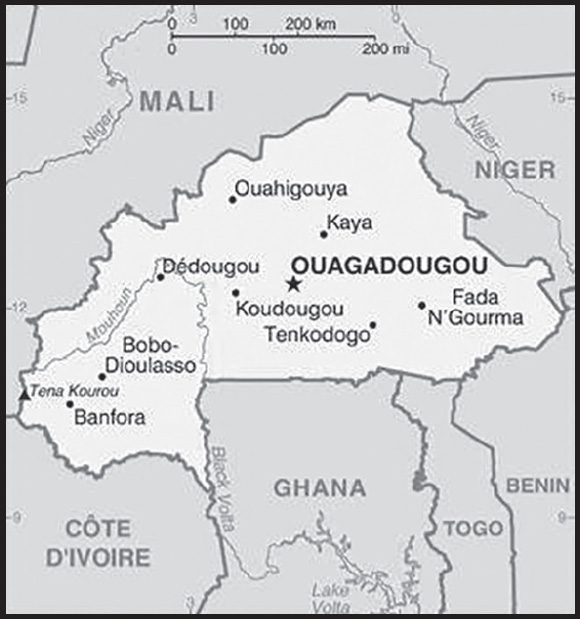
INTRODUCTION
Background: Many of Burkina Faso’s ethnic groups arrived in the region between the 12th and 15th centuries. The Gurma and Mossi peoples established several of the largest kingdoms in the area and used horse-mounted warriors in military campaigns. Of the various Mossi kingdoms, the most powerful were Ouagadougou and Yatenga. In the late 19th century, European states competed for control of the region. France eventually conquered the area and established it as a French protectorate.
The area achieved independence from France in 1960 and changed its name to Burkina Faso in 1984. Repeated military coups were common in the country’s first few decades. The most successful coup occurred in 1987 when Blaise COMPAORE deposed the former president, established a government, and ruled for 27 years. In October 2014, COMPAORE resigned following protests against his repeated efforts to amend the constitution’s two-term presidential limit. An interim administration led a year-long transition period organizing presidential and legislative elections. In November 2015, Roch Marc Christian KABORE was elected president; he was reelected in November 2020. In 2022, military personnel conducted two coups. First, in January 2022, Paul Henri DAMIBA, a colonel in the army, overthrew KABORE and then in September 2022, army captain Ibrahim TRAORE deposed DAMIBA and became transition president. The transition government plans to hold democratic election in July 2024.
Terrorist groups - including groups affiliated with Al-Qa’ida and the Islamic State - began attacks in the country in 2016 and conducted attacks in the capital in 2016, 2017, and 2018. By early 2023, insecurity in Burkina Faso had displaced more than 2 million people and led to significant jumps in humanitarian needs and food insecurity. In addition to terrorism, the country faces a myriad of problems including high population growth, recurring drought, pervasive and perennial food insecurity, and limited natural resources. It is one of the world’s poorest countries.
GEOGRAPHY
Location: Western Africa, north of Ghana
Geographic coordinates: 13 00 N, 2 00 W
Map references: Africa
Area: total: 274,200 sq km
land: 273,800 sq km
water: 400 sq km
comparison ranking: total 76
Area - comparative: slightly larger than Colorado
Land boundaries: total: 3,611 km
border countries (6): Benin 386 km; Cote d’Ivoire 545 km; Ghana 602 km; Mali 1325 km; Niger 622 km; Togo 131 km
Coastline: 0 km (landlocked)
Maritime claims: none (landlocked)
Climate: three climate zones including a hot tropical savanna with a short rainy season in the southern half, a tropical hot semi-arid steppe climate typical of the Sahel region in the northern half, and small area of hot desert in the very north of the country bordering the Sahara Desert
Terrain: mostly flat to dissected, undulating plains; hills in the west and southeast; occupies an extensive plateau with savanna that is grassy in the north and gradually gives way to sparse forests in the south
Elevation: highest point: Tena Kourou 749 m
lowest point: Mouhoun (Black Volta) River 200 m
mean elevation: 297 m
Natural resources: gold, manganese, zinc, limestone, marble, phosphates, pumice, salt
Land use: agricultural land: 44.2% (2018 est.)
arable land: 22% (2018 est.)
permanent crops: 37% (2018 est.)
permanent pasture: 21.93% (2018 est.)
forest: 19.3% (2018 est.)
other: 36.5% (2018 est.)
Irrigated land: 550 sq km (2016)
Major rivers (by length in km): Volta river source (shared with Ghana [m]) - 1,600 km
note – [s] after country name indicates river source; [m] after country name indicates river mouth
Major watersheds (area sq km): Atlantic Ocean drainage: Niger (2,261,741 sq km), Volta (410,991 sq km)
Population distribution: Most of the population is located in the center and south. Nearly one-third of the population lives in cities. The capital and largest city is Ouagadougou (Ouaga), with a population of 1.8 million as shown in this population distribution map
(2019)
Natural hazards: recurring droughts
Geography - note: landlocked savanna cut by the three principal rivers of the Black, Red, and White Voltas
PEOPLE AND SOCIETY
Population: 22,489,126 (2023 est.)
comparison ranking: 60
Nationality: noun: Burkinabe (singular and plural)
adjective: Burkinabe
Ethnic groups: Mossi 52%, Fulani (Peuhl) 8.4%, Gurma 7%, Bobo 4.9%, Gurunsi 4.6%, Senufo 4.5%, Bissa 3.7%, Lobi 2.4%, Dagara 2.4%, Tuareg/Bella 1.9%, Dioula 0.8%, unspecified/no answer 0.3%, other 7.2% (2010 est.)
Languages: Mossi 52.9%, Fula 7.8%, Gourmantche 6.8%, Dyula 5.7%, Bissa 3.3%, Gurunsi 3.2%, French (official) 2.2%, Bwamu 2%, Dagara 2%, San 1.7%, Marka 1.6%, Bobo 1.5%, Senufo 1.5%, Lobi 1.2%, other 6.6% (2019 est.)
Religions: Muslim 63.2%, Roman Catholic 24.6%, Protestant 6.9%, traditional/animist 4.2%, none 0.7%, unspecified 0.4% (2017-18 est.)
Demographic profile: Burkina Faso has a young age structure – the result of declining mortality combined with steady high fertility – and continues to experience rapid population growth, which is putting increasing pressure on the country’s limited arable land. Almost 65% of the population is under the age of 25 as of 2020, and the population is growing at 2.5% annually. Mortality rates, especially those of infants and children, have decreased because of improved health care, hygiene, and sanitation, but women continue to have an average of more than 4 children. Even if fertility were substantially reduced, today’s large cohort entering their reproductive years would sustain high population growth for the foreseeable future. Only about a third of the population is literate and unemployment is widespread, dampening the economic prospects of Burkina Faso’s large working-age population.
Migration has traditionally been a way of life for Burkinabe, with seasonal migration being replaced by stints of up to two years abroad. Cote d’Ivoire remains the top destination, although it has experienced periods of internal conflict. Under French colonization, Burkina Faso became a main labor source for agricultural and factory work in Cote d’Ivoire. Burkinabe also migrated to Ghana, Mali, and Senegal for work between the world wars. Burkina Faso attracts migrants from Cote d’Ivoire, Ghana, and Mali, who often share common ethnic backgrounds with the Burkinabe. Despite its food shortages and high poverty rate, Burkina Faso has become a destination for refugees in recent years and hosts about 33,600 Malian refugees as of October 2022.
(2018)
Age structure: 0-14 years: 42.19% (male 4,813,760/female 4,674,649)
15-64 years: 54.62% (male 5,899,774/female 6,383,134)
65 years and over: 3.19% (2023 est.) (male 305,233/female 412,576)
Dependency ratios: total dependency ratio: 87.4
youth dependency ratio: 82.6
elderly dependency ratio: 4.8
potential support ratio: 20.9 (2021 est.)
Median age: total: 17.9 years (2020)
male: 17 years
female: 18.7 years
comparison ranking: total 216
Population growth rate: 2.46% (2023 est.)
comparison ranking: 23
Birth rate: 32.71 births/1,000 population (2023 est.)
comparison ranking: 22
Death rate: 7.5 deaths/1,000 population (2023 est.)
comparison ranking: 104
Net migration rate: -0.59 migrant(s)/1,000 population (2023 est.)
comparison ranking: 127
Population distribution: Most of the population is located in the center and south. Nearly one-third of the population lives in cities. The capital and largest city is Ouagadougou (Ouaga), with a population of 1.8 million as shown in this population distribution map
(2019)
Urbanization: urban population: 32.5% of total population (2023)
rate of urbanization: 4.75% annual rate of change (2020-25 est.)
Major urban areas - population: 3.204 million OUAGADOUGOU (capital), 1.129 million Bobo-Dioulasso (2023)
Sex ratio: at birth: 1.03 male(s)/female
0-14 years: 1.03 male(s)/female
15-64 years: 0.92 male(s)/female
65 years and over: 0.74 male(s)/female
total population: 0.96 male(s)/female (2023 est.)
Mother’s mean age at first birth: 20.1 years (2021 est.)
note: data represents median age at first birth among women 25-49
Maternal mortality ratio: 264 deaths/100,000 live births (2020 est.)
comparison ranking: 33
Infant mortality rate: total: 48.17 deaths/1,000 live births (2023 est.)
male: 52.39 deaths/1,000 live births
female: 43.83 deaths/1,000 live births
comparison ranking: total 20
Life expectancy at birth: total population: 63.82 years (2023 est.)
male: 61.99 years
female: 65.72 years
comparison ranking: total population 207
Total fertility rate: 4.14 children born/woman (2023 est.)
comparison ranking: 25
Gross reproduction rate: 2.04 (2023 est.)
Contraceptive prevalence rate: 35.3% (2020/21)
Drinking water source: improved: urban: 94.7% of population
rural: 71.3% of population
total: 78.5% of population
unimproved: urban: 5.3% of population
rural: 28.7% of population
total: 21.5% of population (2020 est.)
Current health expenditure: 6.7% of GDP (2020)
Physicians density: 0.09 physicians/1,000 population (2019)
Hospital bed density: 0.4 beds/1,000 population
Sanitation facility access: improved: urban: 90.8% of population
rural: 37.7% of population
total: 54% of population
unimproved: urban: 9.2% of population
rural: 62.3% of population
total: 46% of population (2020 est.)
Major infectious diseases: degree of risk: very high (2023)
food or waterborne diseases: bacterial and protozoal diarrhea, hepatitis A, and typhoid fever
vectorborne diseases: dengue fever and malaria
water contact diseases: schistosomiasis
animal contact diseases: rabies
respiratory diseases: meningococcal meningitis
note: on 31 August 2023, the US Centers for Disease Control and Prevention (CDC) issued a Travel Alert for polio in Africa; Burkina Faso is currently considered a high risk to travelers for circulating vaccine-derived polioviruses (cVDPV); vaccine-derived poliovirus (VDPV) is a strain of the weakened poliovirus that was initially included in oral polio vaccine (OPV) and that has changed over time and behaves more like the wild or naturally occurring virus; this means it can be spread more easily to people who are unvaccinated against polio and who come in contact with the stool or respiratory secretions, such as from a sneeze, of an “infected” person who received oral polio vaccine; the CDC recommends that before any international travel, anyone unvaccinated, incompletely vaccinated, or with an unknown polio vaccination status should complete the routine polio vaccine series; before travel to any high-risk destination, the CDC recommends that adults who previously completed the full, routine polio vaccine series receive a single, lifetime booster dose of polio vaccine
Obesity - adult prevalence rate: 5.6% (2016)
comparison ranking: 175
Alcohol consumption per capita: total: 7.28 liters of pure alcohol (2019 est.)
beer: 1 liters of pure alcohol (2019 est.)
wine: 0.08 liters of pure alcohol (2019 est.)
spirits: 0.31 liters of pure alcohol (2019 est.)
other alcohols: 5.88 liters of pure alcohol (2019 est.)
comparison ranking: total 57
Tobacco use: total: 14.3% (2020 est.)
male: 22.1% (2020 est.)
female: 6.4% (2020 est.)
comparison ranking: total 108
Children under the age of 5 years underweight: 17.5% (2021)
comparison ranking: 27
Currently married women (ages 15-49): 73.5% (2023)
Education expenditures: 5.5% of GDP (2020 est.)
comparison ranking: 58
Literacy: definition: age 15 and over can read and write
total population: 46%
male: 54.5%
female: 37.8% (2021)
School life expectancy (primary to tertiary education): total: 9 years
male: 9 years
female: 9 years (2020)
Youth unemployment rate (ages 15-24): total: 7.7% (2021 est.)
male: 7.5%
female: 8%
comparison ranking: total 171
ENVIRONMENT
Environment - current issues: recent droughts and desertification severely affecting agricultural activities, population distribution, and the economy; overgrazing; soil degradation; deforestation (2019)
Environment - international agreements: party to: Biodiversity, Climate Change, Climate Change-Kyoto Protocol, Climate Change-Paris Agreement, Comprehensive Nuclear Test Ban, Desertification, Endangered Species, Hazardous Wastes, Law of the Sea, Marine Life Conservation, Ozone Layer Protection, Wetlands
signed, but not ratified: Nuclear Test Ban
Climate: three climate zones including a hot tropical savanna with a short rainy season in the southern half, a tropical hot semi-arid steppe climate typical of the Sahel region in the northern half, and small area of hot desert in the very north of the country bordering the Sahara Desert
Land use: agricultural land: 44.2% (2018 est.)
arable land: 22% (2018 est.)
permanent crops: 37% (2018 est.)
permanent pasture: 21.93% (2018 est.)
forest: 19.3% (2018 est.)
other: 36.5% (2018 est.)
Urbanization: urban population: 32.5% of total population (2023)
rate of urbanization: 4.75% annual rate of change (2020-25 est.)
Food insecurity: severe localized food insecurity: due to civil insecurity in the north and high food prices - according to the latest analysis, about 3.53 million people are projected to face acute food insecurity during the June to August 2023 lean season period; this would be a slight increase compared to the preceding year; food insecurity is primarily underpinned by worsening insecurity in Centre-Nord and Sahel regions, which, as of December 2022 (the latest data available), had displaced about 1.88 million people; high food prices further aggravate conditions of the most vulnerable households (2023)
Revenue from forest resources: 4.54% of GDP (2018 est.)
comparison ranking: 14
Revenue from coal: 0% of GDP (2018 est.)
comparison ranking: 165
Air pollutants: particulate matter emissions: 40.74 micrograms per cubic meter (2019 est.)
carbon dioxide emissions: 3.42 megatons (2016 est.)
methane emissions: 12.85 megatons (2020 est.)
Waste and recycling: municipal solid waste generated annually: 2,575,251 tons (2015 est.)
municipal solid waste recycled annually: 309,030 tons (2005 est.)
percent of municipal solid waste recycled: 12% (2005 est.)
Major rivers (by length in km): Volta river source (shared with Ghana [m]) - 1,600 km
note – [s] after country name indicates river source; [m] after country name indicates river mouth
Major watersheds (area sq km): Atlantic Ocean drainage: Niger (2,261,741 sq km), Volta (410,991 sq km)
Total water withdrawal: municipal: 380 million cubic meters (2020 est.)
industrial: 20 million cubic meters (2020 est.)
agricultural: 420 million cubic meters (2020 est.)
Total renewable water resources: 13.5 billion cubic meters (2020 est.)
GOVERNMENT
Country name: conventional long form: none
conventional short form: Burkina Faso
local long form: none
local short form: Burkina Faso
former: Upper Volta, Republic of Upper Volta
etymology: name translates as “Land of the Honest (Incorruptible) Men”
Government type: presidential republic
Capital: name: Ouagadougou
geographic coordinates: 12 22 N, 1 31 W
time difference: UTC 0 (5 hours ahead of Washington, DC, during Standard Time)
etymology: Ouagadougou is a Francophone spelling of the native name “Wogodogo,” meaning “where people get honor and respect”
Administrative divisions: 13 regions; Boucle du Mouhoun, Cascades, Centre, Centre-Est, Centre-Nord, Centre-Ouest, Centre-Sud, Est, Hauts-Bassins, Nord, Plateau-Central, Sahel, Sud-Ouest
Independence: 5 August 1960 (from France)
National holiday: Republic Day, 11 December (1958); note - commemorates the day that Upper Volta became an autonomous republic in the French Community
Constitution: history: several previous; latest approved by referendum 2 June 1991, adopted 11 June 1991, temporarily suspended late October to mid-November 2014; initial draft of a new constitution to usher in the new republic was completed in January 2017 and a final draft was submitted to the government in December 2017; a constitutional referendum originally scheduled for adoption in March 2019 was postponed; on 1 March 2022 a transition charter was adopted, allowing military authorities to rule for three years and barring the transitional president from being an electoral candidate after the transition
amendments: proposed by the president, by a majority of National Assembly membership, or by petition of at least 30,000 eligible voters submitted to the Assembly; passage requires at least three-fourths majority vote in the Assembly; failure to meet that threshold requires majority voter approval in a referendum; constitutional provisions on the form of government, the multiparty system, and national sovereignty cannot be amended; amended several times
Legal system: civil law based on the French model and customary law; in mid-2019, the National Assembly amended the penal code
International law organization participation: has not submitted an ICJ jurisdiction declaration; accepts ICCt jurisdiction
Citizenship: citizenship by birth: no
citizenship by descent only: at least one parent must be a citizen of Burkina Faso
dual citizenship recognized: yes
residency requirement for naturalization: 10 years
Suffrage: 18 years of age; universal
Executive branch: chief of state: transitional President Capt. Ibrahim TRAORE (since 30 September 2022); note - on 30 September 2022, a military junta led by TRAORE, took power and ousted President Lt. Col. Paul-Henri Sandaogo DAMIBA and took over as head of the Patriotic Movement for Safeguard and Restoration
head of government: Prime Minister Albert OUEDRAOGO (since 3 March 2022); note - transitional President Lt. Col. DAMIBA appointed OUEDRAOGO Prime Minister on 3 March 2022; the position had been vacant since 24 January 2022 when the military ousted former Prime Minister Lassina ZERBO
cabinet: Council of Ministers appointed by the president on the recommendation of the prime minister
elections/appointments: president directly elected by absolute majority popular vote in 2 rounds if needed for a 5-year term (eligible for a second term); last held on 22 November 2020 (next to be held by July 2024); prime minister appointed by the president with consent of the National Assembly
election results:
2020: Roch Marc Christian KABORE reelected president in first round; percent of vote - Roch Marc Christian KABORE (MPP) 57.9%, Eddie KOMBOIGO (CDP) 15.5%, Zephirin DIABRE (UPC) 12.5%, other 14.1%
2015: Roch Marc Christian KABORE elected president in first round; percent of vote - Roch Marc Christian KABORE (MPP) 53.5%, Zephirin DIABRE (UPC) 29.6%, Tahirou BARRY (PAREN) 3.1%, Benewende Stanislas SANKARA (UNIR-MS) 2.8%, other 10.9%
Legislative branch: description: unicameral National Assembly (127 seats; 111 members directly elected in 13 multi-seat constituencies by party-list proportional representation vote and 26 members elected in a nationwide constituency by proportional representation vote; members serve 5-year terms)
elections: last held on 22 November 2020 (next to be held by July 2024)
election results: percent of vote by party - MPP 34.6%, CDP 13.3%, UPC 10.2%, NTD 5.6%, other 36.3%; seats by party - MPP 56, CDP 20, NTD 13, UPC 12, other 26; composition as of October 2021 - men 119, women 8, percent of women 6.3%
Judicial branch: highest court(s): Supreme Court of Appeals or Cour de Cassation (consists of NA judges); Council of State (consists of NA judges); Constitutional Council or Conseil Constitutionnel (consists of the council president and 9 members)
judge selection and term of office: Supreme Court judge appointments mostly controlled by the president of Burkina Faso; judges have no term limits; Council of State judge appointment and tenure NA; Constitutional Council judges appointed by the president of Burkina Faso upon the proposal of the minister of justice and the president of the National Assembly; judges appointed for 9-year terms with one-third of membership renewed every 3 years
subordinate courts: Appeals Court; High Court; first instance tribunals; district courts; specialized courts relating to issues of labor, children, and juveniles; village (customary) courts
Political parties and leaders: Act Together [Kadre OUEDRAOGO]
African Democratic Rally/Alliance for Democracy and Federation or ADF/RDA [Gilbert Noel OUEDRAOGO]
Congress for Democracy and Progress or CDP [Eddie KOMBOIGO]
Convergence for Progress and Solidarity-Generation 3 or CPS-G3
Movement for the Future Burkina Faso or MBF
National Convention for Progress or CNP
New Era for Democracy or NTD [Vincent DABILGOU]
Pan-African Alliance for Refoundation or APR
Party for Democracy and Socialism/Metba or PDS/Metba [Philippe OUEDRAOGO]
Party for Development and Change or PDC [Aziz SEREME]
Patriotic Rally for Integrity or RPI
Peoples Movement for Progress or MPP [Roch Marc Christian KABORE]
Progressives United for Renewal or PUR
Union for Progress and Reform or UPC [Zephirin DIABRE]
Union for Rebirth - Sankarist Party or UNIR-PS [Benewende Stanislas SANKARA]
note: only parties with seats in the National Assembly included
International organization participation: ACP, AfDB, AU (suspended), CD, ECOWAS, EITI (compliant country), Entente, FAO, FZ, G-77, IAEA, IBRD, ICAO, ICC (NGOs), ICCt, ICRM, IDA, IDB, IFAD, IFC, IFRCS, ILO, IMF, Interpol, IOC, IOM, IPU, ISO, ITSO, ITU, ITUC (NGOs), MIGA, MINUSCA, MINUSMA, MONUSCO, NAM, OIC, OIF, OPCW, PCA, UN, UNCTAD, UNESCO, UNIDO, UNISFA, UNITAR, UNMISS, UNOOSA, UNWTO, UPU, WADB (regional), WAEMU, WCO, WFTU (NGOs), WHO, WIPO, WMO, WTO
Diplomatic representation in the US: chief of mission: Ambassador (vacant); Chargé d’Affaires Jean-Baptiste GAGRE (since 31 July 2023)
chancery: 2340 Massachusetts Avenue NW, Washington, DC 20008
telephone: [1] (202) 332-5577
FAX: [1] (202) 667-1882
email address and website:
Diplomatic representation from the US: chief of mission: Ambassador Sandra E. CLARK (since 25 September 2020)
embassy: Secteur 15, Ouaga 2000, Avenue Sembene Ousmane, Rue 15.873, Ouagadougou
mailing address: 2440 Ouagadougou Place, Washington, DC 20521-2440
telephone: (226) 25-49-53-00
FAX: (226) 25-49-56-23
email address and website:
Flag description: two equal horizontal bands of red (top) and green with a yellow five-pointed star in the center; red recalls the country’s struggle for independence, green is for hope and abundance, and yellow represents the country’s mineral wealth
note: uses the popular Pan-African colors of Ethiopia
National symbol(s): white stallion; national colors: red, yellow, green
National anthem: name: “Le Ditanye” (Anthem of Victory)
lyrics/music: Thomas SANKARA
note: adopted 1974; also known as “Une Seule Nuit” (One Single Night); written by the country’s former president, an avid guitar player
National heritage: total World Heritage Sites: 3 (2 cultural, 1 natural)
selected World Heritage Site locales: Ruins of Loropéni (c); Ancient Ferrous Metallurgy Sites (c); W-Arly-Pendjari Complex (n)
ECONOMY
Economic overview: highly agrarian, low-income economy; limited natural resources; widespread poverty; terrorism disrupting potential economic activity; improving trade balance via increases in gold exports; economy inflating after prior deflation; growing public debt but still manageable
Real GDP (purchasing power parity): $48.175 billion (2021 est.)
$45.063 billion (2020 est.)
$44.209 billion (2019 est.)
note: data are in 2017 dollars
comparison ranking: 115
Real GDP growth rate: 6.91% (2021 est.)
1.93% (2020 est.)
5.69% (2019 est.)
comparison ranking: 60
Real GDP per capita: $2,200 (2021 est.)
$2,100 (2020 est.)
$2,100 (2019 est.)
note: data are in 2017 dollars
comparison ranking: 208
GDP (official exchange rate): $14.271 billion (2018 est.)
Inflation rate (consumer prices): 3.65% (2021 est.)
1.88% (2020 est.)
-3.23% (2019 est.)
comparison ranking: 104
Credit ratings: Standard & Poors rating: B (2017)
note: The year refers to the year in which the current credit rating was first obtained.
GDP - composition, by sector of origin: agriculture: 31% (2017 est.)
industry: 23.9% (2017 est.)
services: 44.9% (2017 est.)
comparison rankings: services 198; industry 118; agriculture 16
GDP - composition, by end use: household consumption: 56.5% (2017 est.)
government consumption: 23.9% (2017 est.)
investment in fixed capital: 24.6% (2017 est.)
investment in inventories: 1% (2017 est.)
exports of goods and services: 28.4% (2017 est.)
imports of goods and services: -34.4% (2017 est.)
Agricultural products: sorghum, maize, millet, cotton, cow peas, sugar cane, groundnuts, rice, sesame seed, vegetables
Industries: cotton lint, beverages, agricultural processing, soap, cigarettes, textiles, gold
Industrial production growth rate: 8.73% (2021 est.)
comparison ranking: 39
Labor force: 8.016 million (2021 est.)
note: a large part of the male labor force migrates annually to neighboring countries for seasonal employment comparison ranking: 66
Labor force - by occupation: agriculture: 90%
industry and services: 10% (2000 est.)
Unemployment rate: 4.76% (2021 est.)
4.89% (2020 est.)
4.69% (2019 est.)
comparison ranking: 159
Youth unemployment rate (ages 15-24): total: 7.7% (2021 est.)
male: 7.5%
female: 8%
comparison ranking: total 171
Population below poverty line: 41.4% (2018 est.)
Gini Index coefficient - distribution of family income: 47.3 (2018 est.)
comparison ranking: 19
Household income or consumption by percentage share: lowest 10%: 2.9%
highest 10%: 32.2% (2009 est.)
Budget: revenues: $3.212 billion (2019 est.)
expenditures: $3.757 billion (2019 est.)
Budget surplus (+) or deficit (-): -7.9% (of GDP) (2017 est.)
comparison ranking: 198
Public debt: 72.53% of GDP (2020 est.)
46.64% of GDP (2019 est.)
45.57% of GDP (2018 est.)
comparison ranking: 53
Taxes and other revenues: 13.28% (of GDP) (2020 est.)
comparison ranking: 166
Fiscal year: calendar year
Current account balance: $743.232 million (2020 est.)
-$523.837 million (2019 est.)
-$664.797 million (2018 est.)
comparison ranking: 56
Exports: $5.356 billion (2020 est.)
$4.468 billion (2019 est.)
$4.511 billion (2018 est.)
note: Data are in current year dollars and do not include illicit exports or re-exports.
comparison ranking: 125
Exports - partners: Switzerland 59%, India 21% (2019)
Exports - commodities: gold, cotton, zinc, cashews, sesame seeds (2021)
Imports: $4.779 billion (2020 est.) note: data are in current year dollars
$5.023 billion (2019 est.) note: data are in current year dollars
$5.167 billion (2018 est.)
comparison ranking: 145
Imports - partners: Cote d’Ivoire 15%, China 9%, Ghana 8%, France 8%, India 6%, United States 5% (2019)
Imports - commodities: refined petroleum, delivery trucks, packaged medicines, electricity, aircraft (2019)
Reserves of foreign exchange and gold: $49 million (31 December 2017 est.)
$50.9 million (31 December 2016 est.)
comparison ranking: 191
Debt - external: $3.056 billion (31 December 2017 est.)
$2.88 billion (31 December 2016 est.)
comparison ranking: 143
Exchange rates: Communaute Financiere Africaine francs (XOF) per US dollar -
Exchange rates: 554.531 (2021 est.)
575.586 (2020 est.)
585.911 (2019 est.)
555.446 (2018 est.)
580.657 (2017 est.)
ENERGY
Electricity access: population without electricity: 16 million (2020)
electrification - total population: 18.9% (2021)
electrification - urban areas: 67.6% (2021)
electrification - rural areas: 4.7% (2014)
Electricity: installed generating capacity: 392,000 kW (2020 est.)
consumption: 2,033,520,000 kWh (2019 est.)
exports: 0 kWh (2019 est.)
imports: 600 million kWh (2019 est.)
transmission/distribution losses: 248 million kWh (2019 est.)
comparison rankings: installed generating capacity 155; transmission/distribution losses 143; imports 83; exports 109;
consumption: 148
Electricity generation sources: fossil fuels: 89.4% of total installed capacity (2020 est.)
nuclear: 0% of total installed capacity (2020 est.)
solar: 3.3% of total installed capacity (2020 est.)
hydroelectricity: 6.9% of total installed capacity (2020 est.)
biomass and waste: 0.4% of total installed capacity (2020 est.)
Petroleum: total petroleum production: 0 bbl/day (2021 est.)
refined petroleum consumption: 30,800 bbl/day (2019 est.)
Refined petroleum products - production: 0 bbl/day (2015 est.)
comparison ranking: 160
Refined petroleum products - exports: 0 bbl/day (2015 est.)
comparison ranking: 158
Refined petroleum products - imports: 23,580 bbl/day (2015 est.)
comparison ranking: 110
Carbon dioxide emissions: 4.444 million metric tonnes of CO2 (2019 est.)
from petroleum and other liquids: 4.444 million metric tonnes of CO2 (2019 est.)
comparison ranking: total emissions 139
Energy consumption per capita: 3.23 million Btu/person (2019 est.)
comparison ranking: 179
COMMUNICATIONS
Telephones - fixed lines: total subscriptions: 81,374 (2021 est.)
subscriptions per 100 inhabitants: (2021 est.) less than 1
comparison ranking: total subscriptions 142
Telephones - mobile cellular: total subscriptions: 24,678,315 (2021 est.)
subscriptions per 100 inhabitants: 112 (2021 est.)
comparison ranking: total subscriptions 51
Telecommunication systems: general assessment: Burkina Faso’s telecom sector in recent years has made some gains in providing the necessary infrastructure and bandwidth to support telecom services; an IXP completed in September 2020 increased international bandwidth capacity by a third, while in mid-2021 the government was able to start the second phase of a national fiber backbone project; this will link the capital city to an addition 145 municipalities, and provide additional connectivity to terrestrial cables in neighboring countries; the activities of the militants in side areas of the country jeopardize overall security, and render it difficult for the telcos to safeguard their networks and equipment; Burkina Faso joins G5 Sahel countries to eliminate roaming fees (2022)
domestic: fixed-line connections stand at less than 1 per 100 persons; mobile-cellular usage nearly 112 per 100, with multiple providers there is competition and the hope for growth from a low base; Internet penetration is 16% (2021)
international: country code - 226; satellite earth station - 1 Intelsat (Atlantic Ocean)
Broadcast media: since the official inauguration of Terrestrial Digital Television (TNT) in December 2017, Burkina Faso now has 14 digital TV channels among which 2 are state-owned; there are more than 140 radio stations (commercial, religious, community) available throughout the country including a national and regional state-owned network; the state-owned Radio Burkina and the private Radio Omega are among the most widespread stations and both include broadcasts in French and local languages (2019)
Internet country code: .bf
Internet users: total: 4.84 million (2021 est.)
percent of population: 22% (2021 est.)
comparison ranking: total 96
Broadband - fixed subscriptions: total: 13,979 (2020 est.)
subscriptions per 100 inhabitants: 0.1 (2020 est.)
comparison ranking: total 174
TRANSPORTATION
National air transport system: number of registered air carriers: 1 (2020)
inventory of registered aircraft operated by air carriers: 3
annual passenger traffic on registered air carriers: 151,531 (2018)
annual freight traffic on registered air carriers: 100,000 (2018) mt-km
Civil aircraft registration country code prefix: XT
Airports: 23 (2021)
comparison ranking: total 133
Airports - with paved runways: 2
note: paved runways have a concrete or asphalt surface but not all have facilities for refueling, maintenance, or air traffic control; the length of a runway required for aircraft to safely operate depends on a number of factors including the type of aircraft, the takeoff weight (including passengers, cargo, and fuel), engine types, flap settings, landing speed, elevation of the airport, and average maximum daily air temperature; paved runways can reach a length of 5,000 m (16,000 ft.), but the “typical” length of a commercial airline runway is between 2,500-4,000 m (8,000-13,000 ft.)
Airports - with unpaved runways: 21
note: unpaved runways have a surface composition such as grass or packed earth and are most suited to the operation of light aircraft; unpaved runways are usually short, often less than 1,000 m (3,280 ft.) in length; airports with unpaved runways often lack facilities for refueling, maintenance, or air traffic control
Railways: total: 622 km (2014)
narrow gauge: 622 km (2014) 1.000-m gauge
note: another 660 km of this railway extends into Cote d’Ivoire
comparison ranking: total 107
Roadways: total: 15,304 km (2014)
paved: 3,642 km (2014)
unpaved: 11,662 km (2014)
comparison ranking: total 123
MILITARY AND SECURITY
Military and security forces: Armed Forces of Burkina Faso (FABF; aka National Armed Forces (FAN), aka Defense and Security Forces (Forces de Défense et de Sécurité or FDS)): Army of Burkina Faso (L’Armee de Terre, LAT), Air Force of Burkina Faso (Force Aerienne de Burkina Faso), National Gendarmerie, National Fire Brigade (Brigade Nationale de Sapeurs-Pompiers or BNSP); Homeland Defense Volunteers (Forcés de Volontaires de Défense pour la Patrie or VDP)
Ministry of Territorial Administration, Decentralization and Security (Ministère de l’Administration Territoriale, de la Décentralisation et de la Sécurité): National Police (2023)
note 1: the National Gendarmerie officially reports to the Ministry of Defense, but usually operates in support of the Ministry of Territorial Administration, Decentralization, and Security; Gendarmerie troops are typically integrated with Army forces in anti-terrorism operations; specialized counterterrorism units include the Army’s special forces, the Special Legion of the National Gendarmerie, and the Multipurpose Intervention Unit of National Police
note 2: the VDP is a lightly-armed civilian defense/militia force established in 2019 to act as auxiliaries to the Army in the fight against militants; the volunteers receive two weeks of training and typically assist with carrying out surveillance, information-gathering, and escort duties, as well as local defense, and were to be based in each of the country’s more than 300 municipalities; in 2022, the military government created a “Patriotic Watch and Defense Brigade” (La Brigade de Veille et de Défense Patriotique or BVDP) under the FABF to coordinate the VDP recruits
Military expenditures: 2.9% of GDP (2022 est.)
2.4% of GDP (2021 est.)
2.4% of GDP (2020 est.)
2.2% of GDP (2019 est.)
1.9% of GDP (2018 est.)
comparison ranking: 32
Military and security service personnel strengths: approximately 15,500 personnel (10,000 Army; 500 Air Force; 5,000 National Gendarmerie) (2023)
note: in 2022, the Burkina Faso Government announced a special recruitment for up to 6,000 additional soldiers and 1,500 gendarmes to assist with its fight against terrorist groups operating in the country; it also put out a recruitment call for up to 100,000 VDF volunteers, and as of 2023 had as many as 90,000 VDF personnel enrolled (the VDF’s original recruited strength was 15,000)
Military equipment inventories and acquisitions: the FABF has a mix of mostly older or secondhand equipment from a mix of suppliers, including France, Russia, South Africa, Turkey, the UK, and the US (2023)
Military service age and obligation: 18-26 years of age for voluntary military service for men and women (2023)
note: the military junta implemented an emergency law in 2023 that allows the president extensive powers to combat terrorist groups operating in the country, including conscripting citizens into the security services
Military deployments: 650 (plus about 200 police) Mali (MINUSMA) (2023)
note: Burkina Faso is part of a four (formerly five)-nation anti-jihadist task force known as the G4 Sahel Group, set up in 2014 with Chad, Mali (withdrew in 2022), Mauritania, and Niger; it has committed 550 troops and 100 gendarmes to the force; as of 2020, defense forces from each of the participating states were allowed to pursue terrorist fighters up to 100 km into neighboring countries; the force is backed by France, the UN, and the US
Military - note: the FABF has a history of interference in the country’s politics, having conducted eight coups since its formation in 1960-61, including the most recent in September of 2022; several combat units were disbanded in 2011 following mutinies; while the FABF is responsible for external defense, it has an internal security role and can be called out to assist internal security forces in restoring public order, combating crime, securing the border, and counterterrorism; indeed, for more than a decade, its focus has largely been combatting terrorism, and it is actively engaged in combat operations to counter terrorist groups linked to al-Qa’ida and the Islamic State of Iraq and ash-Sham (ISIS), particularly in the northern and eastern regions; the FABF is struggling to contain the groups, however, and a large portion of the country—40% by some estimates—is not under government control in the north, Jama’at Nusrat al-Islam wal-Muslimin (JNIM), a coalition of al-Qa’ida linked militant groups taht act as al- Qa’ida in the Land of the Islamic Magreb’s (AQIM) arm in the Sahel, has exploited ethnic tensions and perceptions of state neglect, as well as grievances over corruption, patronage politics, social stratification, and land disputes; in 2022, JNIM conducted attacks in 10 of the country’s 13 provinces; most of the attacks were assessed to be by the Macina Liberation Front (FLM) of the JNIM coalition; the ISIS-Greater Sahara (ISIS-GS) terrorist group operates in the eastern part of the country
the Army’s combat forces include a mix of about eight small (battalion-sized) infantry and combined arms regiments, plus battalions of artillery and special forces historically deployed in three military regions; in November 2022, the military government announced it was creating six rapid reaction battalions (bataillon de réaction rapide or BIR), expanding the number of military regions to six, and establishing six Gendarmerie “legions”; currently, the Gendarmerie has approximately eight mobile squadrons; in addition to its counterterrorism missions, the Gendarmerie’s Special Legion fights organized crime and provides security for high-level officials and government institutions; the Air Force’s primary mission is providing support to the Army; it has small numbers of combat aircraft, combat helicopters, and armed UAVs acquired from Turkey (2023)
TERRORISM
Terrorist group(s): Terrorist group(s): Ansarul Islam; Islamic State of Iraq and ash-Sham in the Greater Sahara (ISIS-GS); al-Mulathamun Battalion (al-Mourabitoun); Jama’at Nusrat al-Islam wal-Muslimin (JNIM)
note: details about the history, aims, leadership, organization, areas of operation, tactics, targets, weapons, size, and sources of support of the group(s) appear(s) in Appendix-T
TRANSNATIONAL ISSUES
Disputes - international: adding to illicit cross-border activities, Burkina Faso has issues concerning unresolved boundary alignments with its neighbors; demarcation is currently underway with Mali; the dispute with Niger was referred to the ICJ in 2010, and a dispute over several villages with Benin persists; Benin retains a border dispute with Burkina Faso around the town of Koualau/Kourou
Refugees and internally displaced persons: refugees (country of origin): 36,372 (Mali) (2023)
IDPs: 2,062,534 (2023)
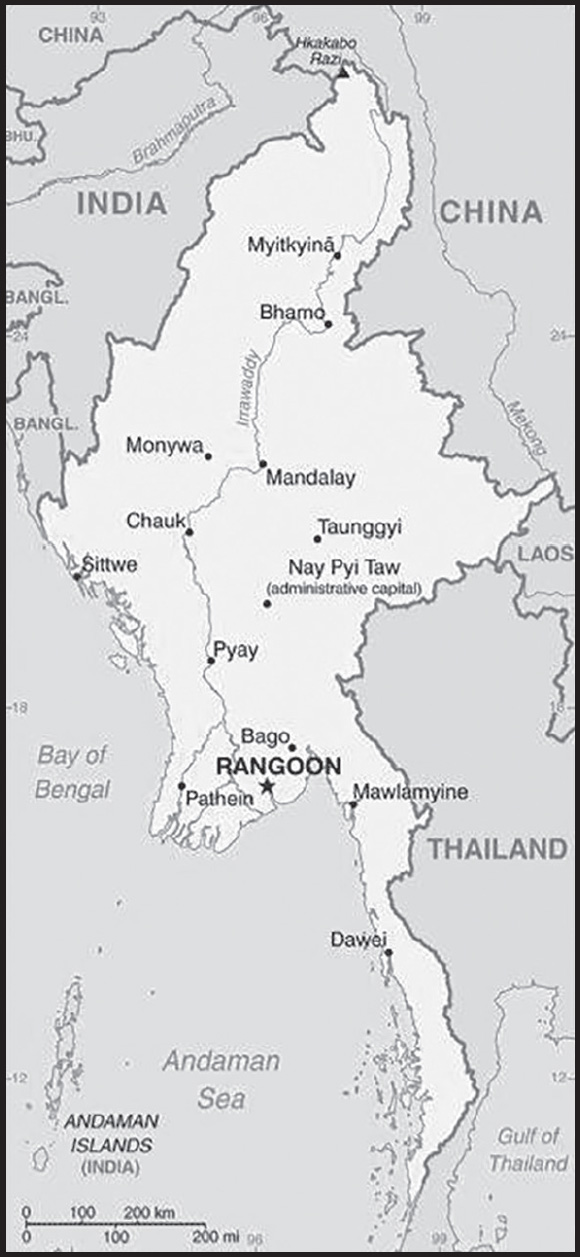
INTRODUCTION
Background: Burma, colonized by Britain in the 19th century and granted independence post-World War II, contains ethnic Burman and scores of other ethnic and religious minority groups that have all resisted external efforts to consolidate control of the country throughout its history, extending to the several minority groups today that possess independent fighting forces and control pockets of territory. In 1962, Gen. NE WIN seized power and ruled Burma until 1988 when a new military regime took control. In 1990, the junta permitted an election but then rejected the results when the main opposition National League for Democracy (NLD) and its leader AUNG SAN SUU KYI (ASSK) won in a landslide. The junta placed ASSK under house arrest for much of the next 20 years, until November 2010. In 2007, rising fuel prices in Burma led pro-democracy activists and Buddhist monks to launch a “Saffron Revolution” consisting of large protests against the ruling junta, which violently suppressed the movement by killing an unknown number of participants and arresting thousands. The regime prevented new elections until it had drafted a constitution designed to preserve its control; it passed the new constitution in its 2008 referendum, days after Cyclone Nargis killed at least 138,000. The junta conducted an election in 2010, but the NLD boycotted the vote, and the military’s Union Solidarity and Development Party easily won; international observers denounced the election as flawed.
With former or current military officers installed in its most senior positions, Burma began a halting process of political and economic reforms. Officials freed prisoners, brokered ceasefires with ethnic armed groups (EAGs), amended courts, expanded civil liberties, brought ASSK into government in 2012, and permitted the NLD in 2015 to take power after a sweeping electoral win. However, Burma’s first credibly elected civilian government, with ASSK as the de facto head of state, faced strong headwinds after five decades of military dictatorship. The NLD government drew international criticism for blocking investigations of Burma’s military for operations, which the US Department of State determined constituted genocide, on its Rohingya population that killed thousands and forced more than 770,000 Rohingya to flee into neighboring Bangladesh. The military did not support an NLD pledge in 2019 to examine reforming the military’s 2008 constitution. When the 2020 elections resulted in further NLD gains, the military denounced them as fraudulent. This challenge led Commander-in-Chief Sr. General MIN AUNG HLAING to launch a coup in February 2021 that has left Burma reeling with the return to authoritarian rule, the detention of ASSK and thousands of pro-democracy actors, and renewed brutal repression against protestors, widespread violence, and economic decline.
Since the coup and subsequent crackdown, members of parliament elected in November 2020 and ousted by the military have formed a shadow National Unity Government (NUG). Members of the NUG include representatives from the NLD, ethnic minority groups, civil society, and other minor parties. In May 2021, the NUG announced the formation of a notional army called the called the People’s Defense Force (PDF), and in September announced the start of an insurgency against the military junta after the formation of hundreds of local armed groups. As of 2023, PDF groups across the country continue to fight the military regime with varying levels of support from and cooperation with the NUG and antiregime EAGs.
GEOGRAPHY
Location: Southeastern Asia, bordering the Andaman Sea and the Bay of Bengal, between Bangladesh and Thailand
Geographic coordinates: 22 00 N, 98 00 E
Map references: Southeast Asia
Area: total: 676,578 sq km
land: 653,508 sq km
water: 23,070 sq km
comparison ranking: total 42
Area - comparative: slightly smaller than Texas
Land boundaries: total: 6,522 km
border countries (5): Bangladesh 271 km; China 2,129 km; India 1,468 km; Laos 238 km; Thailand 2,416 km
Coastline: 1,930 km
Maritime claims: territorial sea: 12 nm
contiguous zone: 24 nm
exclusive economic zone: 200 nm
continental shelf: 200 nm or to the edge of the continental margin
Climate: tropical monsoon; cloudy, rainy, hot, humid summers (southwest monsoon, June to September); less cloudy, scant rainfall, mild temperatures, lower humidity during winter (northeast monsoon, December to April)
Terrain: central lowlands ringed by steep, rugged highlands
Elevation: highest point: Gamlang Razi 5,870 m
lowest point: Andaman Sea/Bay of Bengal 0 m
mean elevation: 702 m
Natural resources: petroleum, timber, tin, antimony, zinc, copper, tungsten, lead, coal, marble, limestone, precious stones, natural gas, hydropower, arable land
Land use: agricultural land: 19.2% (2018 est.)
arable land: 16.5% (2018 est.)
permanent crops: 2.2% (2018 est.)
permanent pasture: 0.5% (2018 est.)
forest: 48.2% (2018 est.)
other: 32.6% (2018 est.)
Irrigated land: 17,140 sq km (2020)
Major rivers (by length in km): Mekong (shared with China [s], Laos, Thailand, Cambodia, and Vietnam [m]) - 4,350 km; Salween river mouth (shared with China [s] and Thailand) - 3,060 km; Irrawaddy river mouth (shared with China [s]) - 2,809 km; Chindwin - 1,158 km
note – [s] after country name indicates river source; [m] after country name indicates river mouth
Major watersheds (area sq km): Indian Ocean drainage: Brahmaputra (651,335 sq km), Ganges (1,016,124 sq km), Irrawaddy (413,710 sq km), Salween (271,914 sq km)
Pacific Ocean drainage: Mekong (805,604 sq km)
Population distribution: population concentrated along coastal areas and in general proximity to the shores of the Irrawaddy River; the extreme north is relatively underpopulated
Natural hazards: destructive earthquakes and cyclones; flooding and landslides common during rainy season (June to September); periodic droughts
Geography - note: strategic location near major Indian Ocean shipping lanes; the north-south flowing Irrawaddy River is the country’s largest and most important commercial waterway
PEOPLE AND SOCIETY
Population: 57,970,293 (2023 est.)
comparison ranking: 26
Nationality: noun: Burmese (singular and plural)
adjective: Burmese
Ethnic groups: Burman (Bamar) 68%, Shan 9%, Karen 7%, Rakhine 4%, Chinese 3%, Indian 2%, Mon 2%, other 5%
note: the largest ethnic group — the Burman (or Bamar) — dominate politics, although they have never managed to bring the entire national territory under their control; the military ranks are largely drawn from this ethnic group; the Burman mainly populate the central parts of the country, while various ethnic minorities have traditionally lived in the peripheral regions that surround the plains in a horseshoe shape; government recognizes 135 indigenous ethnic groups
Languages: Burmese (official)
major-language sample(s):

(Burmese)
note: minority ethnic groups use their own languages
Religions: Buddhist 87.9%, Christian 6.2%, Muslim 4.3%, Animist 0.8%, Hindu 0.5%, other 0.2%, none 0.1% (2014 est.)
note: religion estimate is based on the 2014 national census, including an estimate for the non-enumerated population of Rakhine State, which is assumed to mainly affiliate with the Islamic faith; as of December 2019, Muslims probably make up less than 3% of Burma’s total population due to the large outmigration of the Rohingya population since 2017
Demographic profile: Burma’s 2014 national census – the first in more than 30 years – revealed that the country’s total population is approximately 51.5 million, significantly lower than the Burmese Government’s prior estimate of 61 million. The Burmese Government assumed that the 2% population growth rate between 1973 and 1983 remained constant and that emigration was zero, ignoring later sample surveys showing declining fertility rates and substantial labor migration abroad in recent decades. These factors reduced the estimated average annual growth rate between 2003 and 2014 to about .9%. Among Southeast Asian countries, Burma’s life expectancy is among the lowest and its infant and maternal mortality rates are among the highest. The large difference in life expectancy between women and men has resulted in older age cohorts consisting of far more women than men.
Burma’s demographic transition began in the 1950s, when mortality rates began to drop. Fertility did not start to decrease until the 1960s, sustaining high population growth until the decline accelerated in the 1980s. The birth rate has held fairly steady from 2000 until today. Since the 1970s, the total fertility rate (TFR) has fallen more than 60%, from almost 6 children per woman to 2.2 in 2016. The reduced TFR is largely a result of women marrying later and more women never marrying, both being associated with greater educational attainment and labor force participation among women. TFR, however, varies regionally, between urban and rural areas, by educational attainment, and among ethnic groups, with fertility lowest in urban areas (where it is below replacement level).
The shift in Burma’s age structure has been slow (45% of the population is still under 25 years of age) and uneven among its socioeconomic groups. Any economic boost from the growth of the working-age population is likely to take longer to develop, to have a smaller impact, and to be distributed unequally. Rural poverty and unemployment continue to drive high levels of internal and international migration. The majority of labor migration is internal, mainly from rural to urban areas. The new government’s growing regional integration, reforms, and improved diplomatic relations are increasing the pace of international migration and destination choices. As many as 4-5 million Burmese, mostly from rural areas and several ethnic groups, have taken up unskilled jobs abroad in agriculture, fishing, manufacturing, and domestic service. Thailand is the most common destination, hosting about 70% of Burma’s international migrants, followed by Malaysia, China, and Singapore.
Burma is a patchwork of more than 130 religious and ethnic groups, distinguishing it as one of the most diverse countries in the region. Ethnic minorities face substantial discrimination, and the Rohingya, the largest Muslim group, are arguably the most persecuted population in the country. The Burmese Government and the Buddhist majority see the Rohingya as a threat to identity, competitors for jobs and resources, terrorists, and some still resent them for their alliance with Burma’s British colonizers during its 19th century. Since at least the 1960s, they have been subjected to systematic human rights abuses, violence, marginalization, and disenfranchisement, which authorities continue to deny. Despite living in Burma for centuries, many Burmese see the Rohingya as illegal Bengali immigrants and refer to them Bengalis. As a result, the Rohingya have been classified as foreign residents and stripped of their citizenship, rendering them one of the largest stateless populations in the world.
Hundreds of thousands of Burmese from various ethnic groups have been internally displaced (an estimated 644,000 as of year-end 2016) or have fled to neighboring countries over the decades because of persecution, armed conflict, rural development projects, drought, and natural disasters. Bangladesh has absorbed the most refugees from Burma, with an estimated 33,000 officially recognized and 200,000 to 500,000 unrecognized Rohingya refugees, as of 2016. An escalation in violation has caused a surge in the inflow of Rohingya refugees since late August 2017, raising the number to an estimated 870,000. As of June 2017, another approximately 132,500 refugees, largely Rohingya and Chin, were living in Malaysia, and more than 100,000, mostly Karen, were housed in camps along the Burma-Thailand border.
Age structure: 0-14 years: 24.89% (male 7,394,557/female 7,036,651)
15-64 years: 68.3% (male 19,496,581/female 20,097,806)
65 years and over: 6.8% (2023 est.) (male 1,718,677/female 2,226,021)
Dependency ratios: total dependency ratio: 46
youth dependency ratio: 36.3
elderly dependency ratio: 9.7
potential support ratio: 10.3 (2021 est.)
Median age: total: 29.2 years (2020)
male: 28.3 years
female: 30 years
comparison ranking: total 134
Population growth rate: 0.75% (2023 est.)
comparison ranking: 119
Birth rate: 16.04 births/1,000 population (2023 est.)
comparison ranking: 100
Death rate: 7.14 deaths/1,000 population (2023 est.)
comparison ranking: 115
Net migration rate: -1.36 migrant(s)/1,000 population (2023 est.)
comparison ranking: 157
Population distribution: population concentrated along coastal areas and in general proximity to the shores of the Irrawaddy River; the extreme north is relatively underpopulated
Urbanization: urban population: 32.1% of total population (2023)
rate of urbanization: 1.85% annual rate of change (2020-25 est.)
Major urban areas - population: 5.610 million RANGOON (Yangon) (capital), 1.532 million Mandalay (2023)
Sex ratio: at birth: 1.06 male(s)/female
0-14 years: 1.05 male(s)/female
15-64 years: 0.97 male(s)/female
65 years and over: 0.77 male(s)/female
total population: 0.97 male(s)/female (2023 est.)
Mother’s mean age at first birth: 24.7 years (2015/16 est.)
note: data represents median age at first birth among women 25-49
Maternal mortality ratio: 179 deaths/100,000 live births (2020 est.)
comparison ranking: 50
Infant mortality rate: total: 32.2 deaths/1,000 live births (2023 est.)
male: 35.34 deaths/1,000 live births
female: 28.88 deaths/1,000 live births
comparison ranking: total 45
Life expectancy at birth: total population: 70.21 years (2023 est.)
male: 68.57 years
female: 71.95 years
comparison ranking: total population 172
Total fertility rate: 2 children born/woman (2023 est.)
comparison ranking: 105
Gross reproduction rate: 0.97 (2023 est.)
Contraceptive prevalence rate: 52.2% (2015/16)
Drinking water source: improved: urban: 95.4% of population
rural: 80.7% of population
total: 85.3% of population
unimproved: urban: 4.6% of population
rural: 19.3% of population
total: 14.7% of population (2020 est.)
Current health expenditure: 3.7% of GDP (2020)
Physicians density: 0.74 physicians/1,000 population (2019)
Hospital bed density: 1 beds/1,000 population (2017)
Sanitation facility access: improved: urban: 93.9% of population
rural: 81.3% of population
total: 85.2% of population
unimproved: urban: 6.1% of population
rural: 18.7% of population
total: 14.8% of population (2020 est.)
Major infectious diseases: degree of risk: very high (2023)
food or waterborne diseases: bacterial and protozoal diarrhea, hepatitis A, and typhoid fever
vectorborne diseases: dengue fever, malaria, and Japanese encephalitis
animal contact diseases: rabies
Obesity - adult prevalence rate: 5.8% (2016)
comparison ranking: 173
Alcohol consumption per capita: total: 2.06 liters of pure alcohol (2019 est.)
beer: 0.5 liters of pure alcohol (2019 est.)
wine: 0.02 liters of pure alcohol (2019 est.)
spirits: 1.55 liters of pure alcohol (2019 est.)
other alcohols: 0 liters of pure alcohol (2019 est.)
comparison ranking: total 128
Tobacco use: total: 44.1% (2020 est.)
male: 68.5% (2020 est.)
female: 19.7% (2020 est.)
comparison ranking: total 2
Children under the age of 5 years underweight: 19.1% (2017/18)
comparison ranking: 18
Currently married women (ages 15-49): 57.5% (2023 est.)
Child marriage: women married by age 15: 1.9%
women married by age 18: 16%
men married by age 18: 5% (2016 est.)
Education expenditures: 2.1% of GDP (2019 est.)
comparison ranking: 184
Literacy: definition: age 15 and over can read and write
total population: 89.1%
male: 92.4%
female: 86.3% (2019)
note: most public schools were closed immediately after the coup in 2021, and attendance remained low since schools reopened; literacy is expected to decline from 2019 to 2023
School life expectancy (primary to tertiary education): total: 11 years
male: 10 years
female: 11 years (2018)
Youth unemployment rate (ages 15-24): total: 6.4% (2021 est.)
male: 6.5%
female: 6.3%
comparison ranking: total 181
ENVIRONMENT
Environment - current issues: deforestation; industrial pollution of air, soil, and water; inadequate sanitation and water treatment contribute to disease; rapid depletion of the country’s natural resources
Environment - international agreements: party to: Biodiversity, Climate Change, Climate Change-Kyoto Protocol, Climate Change-Paris Agreement, Comprehensive Nuclear Test Ban, Desertification, Endangered Species, Hazardous Wastes, Law of the Sea, Nuclear Test Ban, Ozone Layer Protection, Ship Pollution, Tropical Timber 2006, Wetlands
signed, but not ratified: none of the selected agreements
Climate: tropical monsoon; cloudy, rainy, hot, humid summers (southwest monsoon, June to September); less cloudy, scant rainfall, mild temperatures, lower humidity during winter (northeast monsoon, December to April)
Land use: agricultural land: 19.2% (2018 est.)
arable land: 16.5% (2018 est.)
permanent crops: 2.2% (2018 est.)
permanent pasture: 0.5% (2018 est.)
forest: 48.2% (2018 est.)
other: 32.6% (2018 est.)
Urbanization: urban population: 32.1% of total population (2023)
rate of urbanization: 1.85% annual rate of change (2020-25 est.)
Food insecurity: severe localized food insecurity: due to conflict, political instability, and economic constraints - the political crisis, following the military takeover on 1 February 2021, resulted in increased tensions and unrest throughout the country; the current uncertain political situation may further compromise the fragile situation of vulnerable households and the Rohingya IDPs residing in the country; armed conflict between the military and non-state armed groups led to population displacements, disrupted agricultural activities and limited access for humanitarian support especially in Rakhine, Chin, Kachin, Kayin, Kayah and Shan states; income losses and a decline in remittances, due to the impact of the COVID-19 pandemic, have affected the food security situation of vulnerable households; domestic prices of Emata rice, the most consumed variety in the country, were at high levels in May 2022, constraining access to a key staple food (2022)
Revenue from forest resources: 1.69% of GDP (2018 est.)
comparison ranking: 38
Revenue from coal: 0.01% of GDP (2018 est.)
comparison ranking: 50
Air pollutants: particulate matter emissions: 27.16 micrograms per cubic meter (2019 est.)
carbon dioxide emissions: 25.28 megatons (2016 est.)
methane emissions: 42.2 megatons (2020 est.)
Waste and recycling: municipal solid waste generated annually: 4,677,307 tons (2000 est.)
Major rivers (by length in km): Mekong (shared with China [s], Laos, Thailand, Cambodia, and Vietnam [m]) - 4,350 km; Salween river mouth (shared with China [s] and Thailand) - 3,060 km; Irrawaddy river mouth (shared with China [s]) - 2,809 km; Chindwin - 1,158 km
note – [s] after country name indicates river source; [m] after country name indicates river mouth
Major watersheds (area sq km): Indian Ocean drainage: Brahmaputra (651,335 sq km), Ganges (1,016,124 sq km), Irrawaddy (413,710 sq km), Salween (271,914 sq km)
Pacific Ocean drainage: Mekong (805,604 sq km)
Total water withdrawal: municipal: 3.32 billion cubic meters (2019 est.)
industrial: 500 million cubic meters (2019 est.)
agricultural: 29.57 billion cubic meters (2019 est.)
Total renewable water resources: 1.2 trillion cubic meters (2020 est.)
GOVERNMENT
Country name: conventional long form: Union of Burma
conventional short form: Burma
local long form: Pyidaungzu Thammada Myanma Naingngandaw (translated as the Republic of the Union of Myanmar)
local short form: Myanma Naingngandaw
former: Socialist Republic of the Union of Burma, Union of Myanmar
etymology: both “Burma” and “Myanmar” derive from the name of the majority Burman (Bamar) ethnic group
note: since 1989 the military authorities in Burma and the deposed parliamentary government have promoted the name Myanmar as a conventional name for their state; the US Government has not officially adopted the name
Government type: previously parliamentary republic
Capital: name: Rangoon (aka Yangon, continues to be recognized as the primary Burmese capital by the US Government); Nay Pyi Taw is the administrative capital
geographic coordinates: 16 48 N, 96 10 E
time difference: UTC+6.5 (11.5 hours ahead of Washington, DC, during Standard Time)
etymology: Rangoon/Yangon derives from the Burmese words yan and koun, which mean “danger” and “no more” respectively and provide the meaning of “end of strife”; Nay Pyi Taw translates as: “Abode of Royals” or “the capital city of a kingdom”
Administrative divisions: 7 regions (taing-myar, singular - taing), 7 states (pyi ne-myar, singular - pyi ne), 1 union territory
regions: Ayeyarwady (Irrawaddy), Bago, Magway, Mandalay, Sagaing, Tanintharyi, Yangon (Rangoon)
states: Chin, Kachin, Kayah, Karen, Mon, Rakhine, Shan
union territory: Nay Pyi Taw
Independence: 4 January 1948 (from the UK)
National holiday: Independence Day, 4 January (1948); Union Day, 12 February (1947)
Constitution: history: previous 1947, 1974 (suspended until 2008); latest drafted 9 April 2008, approved by referendum 29 May 2008
amendments: proposals require at least 20% approval by the Assembly of the Union membership; passage of amendments to sections of the constitution on basic principles, government structure, branches of government, state emergencies, and amendment procedures requires 75% approval by the Assembly and approval in a referendum by absolute majority of registered voters; passage of amendments to other sections requires only 75% Assembly approval; military granted 25% of parliamentary seats by default; amended 2015
Legal system: mixed legal system of English common law (as introduced in codifications designed for colonial India) and customary law
International law organization participation: has not submitted an ICJ jurisdiction declaration; non-party state to the ICCt
Citizenship: citizenship by birth: no
citizenship by descent only: both parents must be citizens of Burma
dual citizenship recognized: no
residency requirement for naturalization: none
note: an applicant for naturalization must be the child or spouse of a citizen
Suffrage: 18 years of age; universal
Executive branch: chief of state: Prime Minister, State Administration Council Chair, Sr. Gen. MIN AUNG HLAING (since 1 August 2021); note - the military took over the government on 1 February 2021 and declared a state of emergency
head of government: Prime Minister, State Administration Council Chair, Sr. Gen. MIN AUNG HLAING (since 1 August 2021)
cabinet: Cabinet appointments shared by the president and the commander-in-chief; note - after 1 February, the military junta replaced the Cabinet
elections/appointments: prior to the military takeover, president was indirectly elected by simple majority vote by the full Assembly of the Union from among 3 vice-presidential candidates nominated by the Presidential Electoral College (consists of members of the lower and upper houses and military members); the other 2 candidates become vice presidents (president elected for a 5-year term); election last held on 28 March 2018; the military junta pledged to hold new elections, but has repeatedly announced delays
election results:
2018: WIN MYINT elected president in an indirect by-election held on 28 March 2018 after the resignation of HTIN KYAW; Assembly of the Union vote - WIN MYINT (NLD) 403, MYINT SWE (USDP) 211, HENRY VAN THIO (NLD) 18, 4 votes canceled (636 votes cast); note - WIN MYINT and other key leaders of the ruling NLD party were placed under arrest following the military takeover on 1 February 2021
2016: Assembly of the Union vote - HTIN KYAW elected president; HTIN KYAW (NLD) 360, MYINT SWE (USDP) 213, HENRY VAN THIO (NLD) 79 (652 votes cast)
state counsellor: State Counselor AUNG SAN SUU KYI (since 6 April 2016); note - under arrest since 1 February 2021; formerly served as Minister of Foreign Affairs and Minister for the Office of the President
note: a parliamentary bill creating the position of “state counsellor” was signed into law by former President HTIN KYAW on 6 April 2016; a state counsellor serves the equivalent term of the president and is similar to a prime minister in that the holder acts as a link between the parliament and the executive branch
Legislative branch: description: dissolved 1 February 2021; previously bicameral Assembly of the Union or Pyidaungsu consists of: House of Nationalities or Amyotha Hluttaw, (224 seats; 168 members directly elected in single-seat constituencies by absolute majority vote with a second round if needed and 56 appointed by the military; members serve 5-year terms) House of Representatives or Pyithu Hluttaw, (440 seats, currently 433; 330 members directly elected in single-seat constituencies by simple majority vote and 110 appointed by the military; members serve 5-year terms); note - on 1 February 2021, the military dissolved the Assembly of the Union and was replaced by the State Administration Council
elections: House of Nationalities - last held on 8 November 2020
House of Representatives - last held on 8 November 2020; note - the military junta overturned the results of the 8 November legislative elections
election results: House of Nationalities - percent of vote by party - NLD 61.6%, USDP 3.1%, ANP 1.8%, MUP 1.3%, KySPD 1.3%, other 5.9%, military appointees 25%; seats by party - NLD 138, USDP 7, ANP 4, MUP 3, KySPD 3, SNLD 2, TNP 2, other 2, vacant 7 (canceled due to insurgency), military appointees 56
House of Representatives - percent of vote by party - NLD 58.6%, USDP 5.9%, SNLD 3.0%, other 7.5%, military 25%; seats by party - NLD 258, USDP 26, SNLD 13, ANP 4, PNO 3, TNP 3, MUP 2, KySPD 2, other 4, vacant 15 (canceled due to insurgency), military appointees 110
Judicial branch: highest court(s): Supreme Court of the Union (consists of the chief justice and 7-11 judges)
judge selection and term of office: chief justice and judges nominated by the president, with approval of the Lower House, and appointed by the president; judges normally serve until mandatory retirement at age 70
subordinate courts: High Courts of the Region; High Courts of the State; Court of the Self-Administered Division; Court of the Self-Administered Zone; district and township courts; special courts (for juvenile, municipal, and traffic offenses); courts martial
Political parties and leaders: Arakan National Party or ANP [THAR TUN HLA]
Democratic Party or DP [U THU WAI]
Kayah State Democratic Party or KySDP
Kayin People’s Party or KPP [TUN AUNG MYINT]
Kokang Democracy and Unity Party or KDUP [LUO XINGGUANG]
La Hu National Development Party or LHNDP [KYA HAR SHAL]
Lisu National Development Party or LNDP [U ARKI DAW]
Mon Unity Party (formed in 2019 from the All Mon Region Democracy Party and Mon National Party)
National Democratic Force or NDF [KHIN MAUNG SWE]
National League for Democracy or NLD [AUNG SAN SUU KYI]
National Unity Party or NUP [U HAN SHWE]
Pa-O National Organization or PNO [AUNG KHAM HTI]
People’s Party [KO KO GYI]
Shan Nationalities Democratic Party or SNDP [SAI AI PAO]
Shan Nationalities League for Democracy or SNLD
Ta’ang National Party or TNP [AIK MONE]
Tai-Leng Nationalities Development Party or TNDP [U SAI HTAY AUNG]
Union Solidarity and Development Party or USDP [THAN HTAY]
Unity and Democracy Party of Kachin State or UDPKS [U KHAT HTEIN NAN]
Wa Democratic Party or WDP [KHUN HTUN LU]
Wa National Unity Party or WNUP [NYI PALOTE]
Zomi Congress for Democracy or ZCD [PU CIN SIAN THANG]
(numerous smaller parties; approximately 90 parties ran in the 2020 election)
note 1: in January 2023, the military junta announced a new law restricting political parties and their ability to participate in elections, including: 1) barring parties and candidates deemed by the junta to have links to individuals or organizations alleged to have committed terrorism or other unlawful acts; 2) stipulating that political parties that wanted to contest the national election would also need to secure at least 100,000 members within 90 days of registration and have funds of 100 million Myanmar kyat ($45,500), 100 times more than previously required, which would need to be deposited with a state-owned bank; 3) requiring that any existing party must apply for registration within 60 days of the legislation being announced or be invalidated; allowing for parties to be suspended for 3 years, and ultimately dissolved, for failing to comply with the provisions of the new law; 4) not allowing parties to lodge an appeal against election commission decisions on registration
note 2: in March 2023, the military junta announced that 40 political parties had been dissolved, including the National League for Democracy, because they did not register under the junta’s new party establishment rules
International organization participation: ADB, ARF, ASEAN, BIMSTEC, CP, EAS, EITI (candidate country), FAO, G-77, IAEA, IBRD, ICAO, ICRM, IDA, IFAD, IFC, IFRCS, IHO, ILO, IMF, IMO, Interpol, IOC, IOM, IPU, ISO (correspondent), ITU, ITUC (NGOs), NAM, OPCW (signatory), SAARC (observer), UN, UNCTAD, UNESCO, UNIDO, UNWTO, UPU, WCO, WHO, WIPO, WMO, WTO
Diplomatic representation in the US: chief of mission: Ambassador (vacant); Chargé d’Affaires WIN Thet (since 22 June 2022)
chancery: 2300 S Street NW, Washington, DC 20008
telephone: [1] (202) 332-3344
FAX: [1] (202) 332-4351
email address and website:
washington-embassy@mofa.gov.mm
https://www.mewashingtondc.org/
consulate(s) general: Los Angeles, New York
Diplomatic representation from the US: chief of mission: Ambassador (vacant); Chargé d’Affaires Susan STEVENSON (since 10 July 2023)
embassy: 110 University Avenue, Kamayut Township, Rangoon
mailing address: 4250 Rangoon Place, Washington DC 20521-4250
telephone: [95] (1) 753-6509
FAX: [95] (1) 751-1069
email address and website:
Flag description: design consists of three equal horizontal stripes of yellow (top), green, and red; centered on the green band is a large white five-pointed star that partially overlaps onto the adjacent colored stripes; the design revives the triband colors used by Burma from 1943-45, during the Japanese occupation
National symbol(s): chinthe (mythical lion); national colors: yellow, green, red, white
National anthem: name: “Kaba Ma Kyei” (Till the End of the World, Myanmar)
lyrics/music: SAYA TIN
note: adopted 1948; Burma is among a handful of non-European nations that have anthems rooted in indigenous traditions; the beginning portion of the anthem is a traditional Burmese anthem before transitioning into a Western-style orchestrated work
National heritage: total World Heritage Sites: 2 (both cultural)
selected World Heritage Site locales: Pyu Ancient Cities; Bagan
ECONOMY
Economic overview: prior to COVID-19 and the February 2021 military coup, massive declines in poverty, rapid economic growth, and improving social welfare; underdevelopment, climate change, and unequal investment threaten progress and sustainability planning; since coup, foreign assistance has ceased from most funding sources
Real GDP (purchasing power parity): $216.948 billion (2021 est.)
$264.29 billion (2020 est.)
$256.16 billion (2019 est.)
note: data are in 2017 dollars
comparison ranking: 65
Real GDP growth rate: -17.91% (2021 est.)
3.17% (2020 est.)
6.75% (2019 est.)
comparison ranking: 222
Real GDP per capita: $4,000 (2021 est.)
$4,900 (2020 est.)
$4,800 (2019 est.)
note: data are in 2017 dollars
comparison ranking: 184
GDP (official exchange rate): $76.606 billion (2019 est.)
Inflation rate (consumer prices): 8.83% (2019 est.)
6.87% (2018 est.)
4.57% (2017 est.)
comparison ranking: 30
GDP - composition, by sector of origin: agriculture: 24.1% (2017 est.)
industry: 35.6% (2017 est.)
services: 40.3% (2017 est.)
comparison rankings: services 212; industry 44; agriculture 31
GDP - composition, by end use: household consumption: 59.2% (2017 est.)
government consumption: 13.8% (2017 est.)
investment in fixed capital: 33.5% (2017 est.)
investment in inventories: 1.5% (2017 est.)
exports of goods and services: 21.4% (2017 est.)
imports of goods and services: -28.6% (2017 est.)
Agricultural products: rice, sugar cane, beans, vegetables, milk, maize, poultry, groundnuts, fruit, plantains
Industries: agricultural processing; wood and wood products; copper, tin, tungsten, iron; cement, construction materials; pharmaceuticals; fertilizer; oil and natural gas; garments; jade and gems
Industrial production growth rate: -20.65% (2021 est.)
comparison ranking: 205
Labor force: 22.122 million (2021 est.)
comparison ranking: 30
Labor force - by occupation: agriculture: 70%
industry: 7%
services: 23% (2001 est.)
Unemployment rate: 2.17% (2021 est.)
1.06% (2020 est.)
0.5% (2019 est.)
comparison ranking: 209
Youth unemployment rate (ages 15-24): total: 6.4% (2021 est.)
male: 6.5%
female: 6.3%
comparison ranking: total 181
Population below poverty line: 24.8% (2017 est.)
Gini Index coefficient - distribution of family income: 30.7 (2017 est.)
comparison ranking: 145
Average household expenditures: on food: 56.1% of household expenditures (2018 est.)
on alcohol and tobacco: 0.5% of household expenditures (2018 est.)
Household income or consumption by percentage share: lowest 10%: 2.8%
highest 10%: 32.4% (1998)
Budget: revenues: $13.361 billion (2020 est.)
expenditures: $18.035 billion (2020 est.)
Budget surplus (+) or deficit (-): -3.2% (of GDP) (2017 est.)
comparison ranking: 137
Public debt: 33.6% of GDP (2017 est.)
35.7% of GDP (2016 est.)
comparison ranking: 159
Taxes and other revenues: 6.44% (of GDP) (2019 est.)
comparison ranking: 215
Fiscal year: 1 April - 31 March
Current account balance: $67.72 million (2019 est.)
-$2.561 billion (2018 est.)
-$4.917 billion (2017 est.)
comparison ranking: 69
Exports: $20.4 billion (2021 est.) note: data are in current year dollars
$17.523 billion (2019 est.) note: data are in current year dollars
$15.728 billion (2018 est.) note: data are in current year dollars
note: Data are in current year dollars and do not include illicit exports or re-exports.
comparison ranking: 86
Exports - partners: China 34%, Thailand 14%, Germany 6%, Japan 5%, United States 5% (2021)
Exports - commodities: natural gas, clothing products, dried legumes, precious stones, yttrium, scandium, rice, corn (2021)
note: Burmese methamphetamine production and opiate production remain significant illicit trade commodities
Imports: $23.1 billion (2021 est.) note: data are in current year dollars
$17.356 billion (2019 est.) note: data are in current year dollars
$18.664 billion (2018 est.) note: data are in current year dollars
note: import figures are grossly underestimated due to the value of consumer goods, diesel fuel, and other products smuggled in from Thailand, China, Malaysia, and India
comparison ranking: 85
Imports - partners: China 43%, Thailand 15%, Singapore 12%, Indonesia 5% (2019)
Imports - commodities: refined petroleum, broadcasting equipment, fabrics, motorcycles, packaged medicines (2019)
Reserves of foreign exchange and gold: $7.67 billion (31 December 2020 est.)
$5.824 billion (31 December 2019 est.)
$5.646 billion (31 December 2018 est.)
comparison ranking: 93
Debt - external: $6.594 billion (31 December 2017 est.)
$8.2 billion (31 December 2016 est.)
comparison ranking: 125
Exchange rates: kyats (MMK) per US dollar -
Exchange rates: 1,381.619 (2020 est.)
1,518.255 (2019 est.)
1,429.808 (2018 est.)
1,360.359 (2017 est.)
1,234.87 (2016 est.)
ENERGY
Electricity access: population without electricity: 26 million (2020)
electrification - total population: 72.4% (2021)
electrification - urban areas: 93.6% (2021)
electrification - rural areas: 62.7% (2021)
Electricity: installed generating capacity: 7.247 million kW (2020 est.)
consumption: 20,474,380,000 kWh (2019 est.)
exports: 1.002 billion kWh (2019 est.)
imports: 0 kWh (2019 est.)
transmission/distribution losses: 3.405 billion kWh (2019 est.)
comparison rankings: installed generating capacity 77; transmission/distribution losses 61; imports 172; exports 60; consumption 72
Electricity generation sources: fossil fuels: 52.6% of total installed capacity (2020 est.)
solar: 0.1% of total installed capacity (2020 est.)
hydroelectricity: 47.3% of total installed capacity (2020 est.)
Coal: production: 1.468 million metric tons (2020 est.)
consumption: 1.981 million metric tons (2020 est.)
exports: 1,000 metric tons (2020 est.)
imports: 514,000 metric tons (2020 est.)
proven reserves: 6 million metric tons (2019 est.)
Petroleum: total petroleum production: 7,800 bbl/day (2021 est.)
refined petroleum consumption: 146,200 bbl/day (2019 est.)
crude oil and lease condensate exports: 4,700 bbl/day (2018 est.)
crude oil and lease condensate imports: 0 bbl/day (2018 est.)
crude oil estimated reserves: 139 million barrels (2021 est.)
Refined petroleum products - production: 13,330 bbl/day (2017 est.)
comparison ranking: 97
Refined petroleum products - exports: 0 bbl/day (2015 est.)
comparison ranking: 176
Refined petroleum products - imports: 102,600 bbl/day (2015 est.)
comparison ranking: 53
Natural gas: production: 17,710,912,000 cubic meters (2019 est.)
consumption: 3,612,431,000 cubic meters (2019 est.)
exports: 14,188,161,000 cubic meters (2019 est.)
imports: 475.156 million cubic meters (2020 est.)
proven reserves: 637.128 billion cubic meters (2021 est.)
Carbon dioxide emissions: 31.848 million metric tonnes of CO2 (2019 est.)
from coal and metallurgical coke: 3.881 million metric tonnes of CO2 (2019 est.)
from petroleum and other liquids: 20.832 million metric tonnes of CO2 (2019 est.)
from consumed natural gas: 7.134 million metric tonnes of CO2 (2019 est.)
comparison ranking: total emissions 75
Energy consumption per capita: 10.679 million Btu/person (2019 est.)
comparison ranking: 154
COMMUNICATIONS
Telephones - fixed lines: total subscriptions: 522,141 (2021 est.)
subscriptions per 100 inhabitants: 1 (2021 est.)
comparison ranking: total subscriptions 91
Telephones - mobile cellular: total subscriptions: 67,930,093 (2021 est.)
subscriptions per 100 inhabitants: 126 (2021 est.)
comparison ranking: total subscriptions 25
Telecommunication systems: general assessment: Burma, one of the least developed telecom markets in Asia, saw growth in mobile and broadband services through foreign competition and roll out of 4G and 5G networks; infrastructure development challenged by flooding, unreliable electricity, inefficient bureaucracy, and corruption; digital divide affects rural areas; fixed broadband remains low due to number of fixed-lines and near saturation of the mobile platform; healthy m-banking platform; tests for NB-IoT; benefit from launch of regional satellite; government utilizes intermittent censorship and shut-down of Internet in political crisis (2020)
domestic: fixed-line is just under 1 per 100, while mobile-cellular is roughly 126 per 100 (2021)
international: country code - 95; landing points for the SeaMeWe-3, SeaMeWe-5, AAE-1 and Singapore-Myanmar optical telecommunications submarine cable that provides links to Asia, the Middle East, Africa, Southeast Asia, Australia and Europe; satellite earth stations - 2, Intelsat (Indian Ocean) and ShinSat (2019)
Broadcast media: government controls all domestic broadcast media; 2 state-controlled TV stations with 1 of the stations controlled by the armed forces; 2 pay-TV stations are joint state-private ventures; 1 state-controlled domestic radio station and 9 FM stations that are joint state-private ventures; transmissions of several international broadcasters are available in parts of Burma; the Voice of America (VOA), Radio Free Asia (RFA), BBC Burmese service, the Democratic Voice of Burma (DVB), and Radio Australia use shortwave to broadcast in Burma; VOA, RFA, and DVB produce daily TV news programs that are transmitted by satellite to audiences in Burma; in March 2017, the government granted licenses to 5 private broadcasters, allowing them digital free-to-air TV channels to be operated in partnership with government-owned Myanmar Radio and Television (MRTV) and will rely upon MRTV’s transmission infrastructure; following the February 2021 military coup, the regime revoked the media licenses of most independent outlets, including the free-to-air licenses for DVB and Mizzima (2022)
Internet country code: .mm
Internet users: total: 23.76 million (2021 est.)
percent of population: 44% (2021 est.)
comparison ranking: total 36
Broadband - fixed subscriptions: total: 688,185 (2020 est.)
subscriptions per 100 inhabitants: 1 (2020 est.)
comparison ranking: total 81
TRANSPORTATION
National air transport system: number of registered air carriers: 8 (2020)
inventory of registered aircraft operated by air carriers: 42
annual passenger traffic on registered air carriers: 3,407,788 (2018)
annual freight traffic on registered air carriers: 4.74 million (2018) mt-km
Civil aircraft registration country code prefix: XY
Airports: 64 (2021)
comparison ranking: total 77
Airports - with paved runways: 36
note: paved runways have a concrete or asphalt surface but not all have facilities for refueling, maintenance, or air traffic control; the length of a runway required for aircraft to safely operate depends on a number of factors including the type of aircraft, the takeoff weight (including passengers, cargo, and fuel), engine types, flap settings, landing speed, elevation of the airport, and average maximum daily air temperature; paved runways can reach a length of 5,000 m (16,000 ft.), but the “typical” length of a commercial airline runway is between 2,500-4,000 m (8,000-13,000 ft.)
Airports - with unpaved runways: 28
note: unpaved runways have a surface composition such as grass or packed earth and are most suited to the operation of light aircraft; unpaved runways are usually short, often less than 1,000 m (3,280 ft.) in length; airports with unpaved runways often lack facilities for refueling, maintenance, or air traffic control
Heliports: 11 (2021)
Pipelines: 3,739 km gas, 1321 km oil (2017)
Railways: total: 5,031 km (2008)
narrow gauge: 5,031 km (2008) 1.000-m gauge
comparison ranking: total 39
Roadways: total: 157,000 km (2013)
paved: 34,700 km (2013)
unpaved: 122,300 km (2013)
comparison ranking: total 33
Waterways: 12,800 km (2011)
comparison ranking: 11
Merchant marine: total: 102 (2022)
by type: bulk carrier 1, general cargo 45, oil tanker 5, other 51
comparison ranking: total 88
Ports and terminals: major seaport(s): Mawlamyine (Moulmein), Sittwe
river port(s): Rangoon (Yangon) (Rangoon River)
MILITARY AND SECURITY
Military and security forces: Burmese Defense Service (aka Armed Forces of Burma, Myanmar Army, Royal Armed Forces, the Tatmadaw, or the Sit- Tat): Army (Tatmadaw Kyi), Navy (Tatmadaw Yay), Air Force (Tatmadaw Lay); People’s Militia
Ministry of Home Affairs: Burma (People’s) Police Force, Border Guard Forces/Police (2023)
note 1: under the 2008 constitution, the Tatmadaw controls appointments of senior officials to lead the Ministry of Defense, the Ministry of Border Affairs, and the Ministry of Home Affairs; in March 2022, a new law gave the commander-in-chief of the Tatmadaw the authority to appoint or remove the head of the police force
note 2: the Burma Police Force is primarily responsible for internal security; the Border Guard Police is administratively part of the Burma Police Force but operationally distinct; both are under the Ministry of Home Affairs, which is led by an active-duty military general and itself subordinate to the military command
Military expenditures: 3% of GDP (2022 est.)
3.3% of GDP (2021 est.)
3% of GDP (2020 est.)
4.1% of GDP (2019 est.)
4.4% of GDP (2018 est.)
comparison ranking: 27
Military and security service personnel strengths: estimates vary widely, from approximately 150,000 to as many as 400,000 active personnel (2023)
Military equipment inventories and acquisitions: the Burmese military inventory is comprised mostly of older Chinese and Russian/Soviet-era equipment with a smaller mix of more modern acquisitions from a variety of countries; in recent years, China and Russia have been the leading suppliers of military hardware; Burma has a limited defense industry, including a growing shipbuilding capability and some production of ground force equipment that is largely based on Chinese and Russian designs (2023)
Military service age and obligation: 18-35 years of age (men) and 18-27 years of age (women) for voluntary military service; no conscription (a 2010 law reintroducing conscription has not yet entered into force); 2-year service obligation; professional men (ages 18-45) and women (ages 18-35), including doctors, engineers, and mechanics, serve up to 3 years; service terms may be stretched to 5 years in an officially declared emergency (2023)
Military - note: since the country’s founding, the Tatmadaw has been heavily involved in domestic politics and the national economy; it ran the country for five decades following a military coup in 1962; prior to the most recent coup in 2021, the military already controlled three key security ministries (Defense, Border, and Home Affairs), one of two vice presidential appointments, 25% of the parliamentary seats, and had a proxy political party, the Union Solidarity and Development Party (USDP); it owns and operates two business conglomerates that have over 100 subsidiaries; the business activities of these conglomerates include banking and insurance, hotels, tourism, jade and ruby mining, timber, construction, real estate, and the production of palm oil, sugar, soap, cement, beverages, drinking water, coal, and gas; some of the companies supply goods and services to the military, such as food, clothing, insurance, and cellphone service; the military also manages a film industry, publishing houses, and television stations
the Tatmadaw’s primary operational focus is internal security, and it is conducting widespread counterinsurgency operations against anti-regime forces that launched an armed rebellion following the 2021 coup and an array of ethnic armed groups (EAGs), some of which have considerable military capabilities; it has been accused of committing atrocities in the conduct of its campaign against the pro-democracy movement and opposition forces
the Army is the dominant service and largely configured for counterinsurgency operations, although it has some conventional warfare capabilities; its principal combat forces are organized into 10 centrally-commanded light infantry/rapid reaction divisions, which have a key role in fighting against insurgents; the light infantry divisions are supported by approximately 20 regionally-based, divisional-sized “military operations commands,” and several brigade-sized “regional operations commands”; the Army’s insurgency operations are supported by the National Police, which has dozens of paramilitary combat police battalions; the Air Force also has a large counterinsurgency role with more than 100 combat-capable aircraft and helicopters, mostly ground attack aircraft and helicopter gunships, complemented by some multipurpose fighters; the Navy has traditionally been a coastal defense force, and the majority of the combat fleet consists of fast attack and patrol vessels; however, in recent years the Navy has expanded its blue water capabilities and has a small force of frigates and corvettes, as well as a landing platform docking (LPD) amphibious assault ship and 2 attack submarines acquired since 2020
the military is supported by hundreds of pro-government militias; some are integrated within the Tatmadaw’s command structure as Border Guard Forces, which are organized as battalions with a mix of militia forces, ethnic armed groups, and government soldiers that are armed, supplied, and paid by the Tatmadaw; other pro-military government militias are not integrated within the Tatmadaw command structure but receive direction and some support from the military and are recognized as government militias; a third type of pro-government militias are small community-based units that are armed, coordinated, and trained by local Tatmadaw forces and activated as needed; the junta has raised new militia units to help combat the popular uprising
EAGs have been fighting for self-rule against the Burmese Government since 1948; there are approximately 20 such groups operating in Burma with strengths of a few hundred up to more than 25,000 estimated fighters; some are organized along military lines with “brigades” and “divisions” and armed with heavy weaponry, including artillery; they control large tracts of the country’s territory, primarily in the border regions; key groups include the United Wa State Army, Karen National Union, Kachin Independence Army, Arakan Army, Ta’ang National Liberation Army, and the Myanmar Nationalities Democratic Alliance Army
the opposition National Unity Government claims its armed wing, the People’s Defense Force (PDF), has more than 60,000 fighters loosely organized into battalions; in addition, several EAGs have cooperated with the NUG and supported local PDF groups (2023)
TRANSNATIONAL ISSUES
Disputes - international: over half of Burma’s population consists of diverse ethnic groups who have substantial numbers of kin in neighboring countries; Bangladesh struggles to accommodate 912,000 Rohingya, Burmese Muslim minority from Rakhine State, living as refugees in Cox’s Bazar; Burmese border authorities are constructing a 200 km (124 mi) wire fence designed to deter illegal cross-border transit and tensions from the military build-up along border with Bangladesh in 2010; Bangladesh referred its maritime boundary claims with Burma and India to the International Tribunal on the Law of the Sea; Burmese forces attempting to dig in to the largely autonomous Shan State to rout local militias tied to the drug trade, prompts local residents to periodically flee into neighboring Yunnan Province in China; fencing along the India-Burma international border at Manipur’s Moreh town is in progress to check illegal drug trafficking and movement of militants; over 100,000 mostly Karen refugees and asylum seekers fleeing civil strife, political upheaval, and economic stagnation in Burma were living in remote camps in Thailand near the border as of May 2017
Refugees and internally displaced persons: IDPs: 1.975 million (government offensives against armed ethnic minority groups near its borders with China and Thailand, natural disasters, forced land evictions) (2023)
stateless persons: 600,000 (2022); note - Rohingya Muslims, living predominantly in Rakhine State, are Burma’s main group of stateless people; the Burmese Government does not recognize the Rohingya as a “national race” and stripped them of their citizenship under the 1982 Citizenship Law, categorizing them as “non-nationals” or “foreign residents;” under the Rakhine State Action Plan drafted in October 2014, the Rohingya must demonstrate their family has lived in Burma for at least 60 years to qualify for a lesser naturalized citizenship and the classification of Bengali or be put in detention camps and face deportation; native-born but non-indigenous people, such as Indians, are also stateless; the Burmese Government does not grant citizenship to children born outside of the country to Burmese parents who left the country illegally or fled persecution, such as those born in Thailand; the number of stateless persons has decreased dramatically because hundreds of thousands of Rohingya have fled to Bangladesh since 25 August 2017 to escape violence
Trafficking in persons: tier rating: Tier 3 — Burma does not fully meet the minimum standards for the elimination of trafficking and is not making significant efforts to do so, therefore Burma remained on Tier 3; the military continued the use of children and adults for forced labor; the regime did not prosecute any military or deposed government officials for the forced labor, and it prevented civil society organizations from assisting trafficking victims; displacement resulting from military conflict, exacerbated by the February 2021 military coup that deposed the democratically elected government, made Rohingya and other ethnic groups more vulnerable to human trafficking (2022)
trafficking profile: human traffickers exploit men, women, and children through forced labor, and women and children in sex trafficking in Burma and abroad; Burmese men are forced to work domestically and abroad in fishing, manufacturing, forestry, agriculture, and construction; fishermen are lured into forced labor in remote waters and offshore by recruitment agencies in Burma and Southeast Asia; Burmese women increasingly are lured to China for marriage under false pretenses and are subjected to sex trafficking, forced concubinism and childbearing, and forced domestic labor; men, women, and children in ethnic minority areas are at increased risk of sex trafficking and forced labor in farming, manufacturing, and construction; men and boys are recruited locally by traffickers for forced labor in oil palm and rubber plantations, in mining, fishing, and bamboo, teak, and rice harvesting; some military personnel, civilian brokers, border guard officials, and ethnic armed groups continue to recruit child soldiers, particularly in conflict areas; discriminatory laws and hiring practices put LGBTQI+ individuals at higher risk for trafficking (2022)
Illicit drugs: source of precursor or essential chemicals used in the production of illicit narcotics; narcotics produced in Burma trafficked throughout the region, with routes extending beyond Southeast Asia to Australia, New Zealand, and Japan; second-largest opium poppy cultivator in Asia with an estimated 40,100 hectares grown in 2022; not a major source or transit country for drugs entering the United States; domestic consumption of synthetic drug cocktails such as “Happy Water” and “Wei Tiong” (mixtures of drugs including caffeine, methamphetamine, tramadol, and MDMA) popular among the younger population and domestic drug consumption substantial and widespread. (2021)
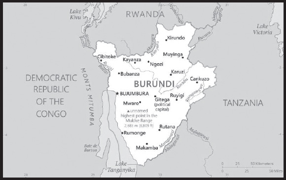
INTRODUCTION
Background: Established in the 1600s, the Burundi Kingdom has had borders similar to those of modern Burundi since the 1800s. Burundi’s two major ethnic groups, the majority Hutu and minority Tutsi, share a common language and culture and largely lived in peaceful cohabitation under Tutsi monarchs in pre-colonial Burundi. Regional, class, and clan distinctions contributed to social status in the Burundi Kingdom, yielding a complex class structure. German colonial rule in the late 19th and early 20th centuries and Belgian rule after World War I preserved Burundi’s monarchy. Seeking to simplify administration, Belgian colonial officials reduced the number of chiefdoms and eliminated most Hutu chiefs from positions of power. In 1961, the Burundian Tutsi king’s oldest son, Louis RWAGASORE was murdered by a competing political faction shortly before he was set to become prime minister, triggering increased political competition that contributed to later instability. Burundi gained its independence from Belgium in 1962 as the Kingdom of Burundi.
Revolution in neighboring Rwanda stoked ethnic polarization as the Tutsi increasingly feared violence and loss of political power. A failed Hutu-led coup in 1965 triggered a purge of Hutu officials and set the stage for Tutsi officers to overthrow the monarchy in 1966 and establish a Tutsi-dominated republic. A Hutu rebellion in 1972 that resulted in the death of several thousand Tutsi civilians sparked a brutal crackdown on Hutu civilians by the Tutsi-led military, which ultimately killed 100,000-200,000 people. International pressure led to a new constitution in 1992 and democratic elections in June 1993. Burundi’s first democratically elected president, Hutu Melchior NDADAYE, was assassinated in October 1993 after only 100 days in office by Tutsi military officers fearing Hutu domination, sparking a civil war. His successor, Cyprien NTARYAMIRA, died when the Rwandan president’s plane he was traveling on was shot down in April 1994, which triggered the Rwandan genocide and further entrenched ethnic conflict in Burundi. The internationally brokered Arusha Agreement, signed in 2000, and subsequent cease-fire agreements with armed movements ended the 1993-2005 civil war. Burundi’s second democratic elections were held in 2005, resulting in the election of Pierre NKURUNZIZA as president. He was reelected in 2010 and again in 2015 after a controversial court decision allowed him to circumvent a term limit. President Evariste NDAYISHIMIYE - from NKURUNZIZA’s ruling party - was elected in 2020.
GEOGRAPHY
Location: Central Africa, east of the Democratic Republic of the Congo, west of Tanzania
Geographic coordinates: 3 30 S, 30 00 E
Map references: Africa
Area: total: 27,830 sq km
land: 25,680 sq km
water: 2,150 sq km
comparison ranking: total 146
Area - comparative: slightly smaller than Maryland
Land boundaries: total: 1,140 km
border countries (3): Democratic Republic of the Congo 236 km; Rwanda 315 km; Tanzania 589 km
Coastline: 0 km (landlocked)
Maritime claims: none (landlocked)
Climate: equatorial; high plateau with considerable altitude variation (772 m to 2,670 m above sea level); average annual temperature varies with altitude from 23 to 17 degrees Celsius but is generally moderate as the average altitude is about 1,700 m; average annual rainfall is about 150 cm; two wet seasons (February to May and September to November), and two dry seasons (June to August and December to January)
Terrain: hilly and mountainous, dropping to a plateau in east, some plains
Elevation: highest point: unnamed elevation on Mukike Range 2,685 m
lowest point: Lake Tanganyika 772 m
mean elevation: 1,504 m
Natural resources: nickel, uranium, rare earth oxides, peat, cobalt, copper, platinum, vanadium, arable land, hydropower, niobium, tantalum, gold, tin, tungsten, kaolin, limestone
Land use: agricultural land: 73.3% (2018 est.)
arable land: 38.9% (2018 est.)
permanent crops: 15.6% (2018 est.)
permanent pasture: 18.8% (2018 est.)
forest: 6.6% (2018 est.)
other: 20.1% (2018 est.)
Irrigated land: 230 sq km (2012)
Major lakes (area sq km): fresh water lake(s): Lake Tanganyika (shared with Democratic Republic of Congo, Tanzania, and Zambia) - 32,000 sq km
Major watersheds (area sq km): Atlantic Ocean drainage: Congo (3,730,881 sq km), (Mediterranean Sea) Nile (3,254,853 sq km)
Population distribution: one of Africa’s most densely populated countries; concentrations tend to be in the north and along the northern shore of Lake Tanganyika in the west; most people live on farms near areas of fertile volcanic soil as shown in this population distribution map
Natural hazards: flooding; landslides; drought
Geography - note: landlocked; straddles crest of the Nile-Congo watershed; the Kagera, which drains into Lake Victoria, is the most remote headstream of the White Nile
PEOPLE AND SOCIETY
Population: 13,162,952 (2023 est.)
comparison ranking: 77
Nationality: noun: Burundian(s)
adjective: Burundian
Ethnic groups: Hutu, Tutsi, Twa, Phuthi, South Asian
Languages: Kirundi (official), French (official), English (official, least spoken), Swahili (2008 est.)
major-language sample(s): Igitabo Mpuzamakungu c’ibimenyetso bifatika, isoko ntabanduka ku nkuru z’urufatiro. (Kirundi)
note: data represent languages read and written by people 10 years of age or older; spoken Kirundi is nearly universal
Religions: Roman Catholic 58.6%, Protestant 35.3% (includes Adventist 2.7% and other Protestant 32.6%), Muslim 3.4%, other 1.3%, none 1.3% (2016-17 est.)
Demographic profile: Burundi is a densely populated country with a high population growth rate, factors that combined with land scarcity and poverty place a large share of its population at risk of food insecurity. About 90% of the population relies on subsistence agriculture. Subdivision of land to sons, and redistribution to returning refugees, results in smaller, overworked, and less-productive plots. Food shortages, poverty, and a lack of clean water contribute to a 60% chronic malnutrition rate among children. A lack of reproductive health services has prevented a significant reduction in Burundi’s maternal mortality and fertility rates, which are both among the world’s highest. With almost two-thirds of its population under the age of 25 and a birth rate of about 5 children per woman as of 2022, Burundi’s population will continue to expand rapidly for decades to come, putting additional strain on a poor country.
Historically, migration flows into and out of Burundi have consisted overwhelmingly of refugees from violent conflicts. In the last decade, more than a half million Burundian refugees returned home from neighboring countries, mainly Tanzania. Reintegrating the returnees has been problematic due to their prolonged time in exile, land scarcity, poor infrastructure, poverty, and unemployment. Repatriates and existing residents (including internally displaced persons) compete for limited land and other resources. To further complicate matters, international aid organizations reduced their assistance because they no longer classified Burundi as a post-conflict country. Conditions deteriorated when renewed violence erupted in April 2015, causing another outpouring of refugees. In addition to refugee out-migration, Burundi has hosted thousands of refugees from neighboring countries, mostly from the Democratic Republic of the Congo and lesser numbers from Rwanda.
Age structure: 0-14 years: 42.67% (male 2,830,996/female 2,786,154)
15-64 years: 54.03% (male 3,523,380/female 3,588,511)
65 years and over: 3.3% (2023 est.) (male 187,176/female 246,735)
Dependency ratios: total dependency ratio: 95.2
youth dependency ratio: 90.4
elderly dependency ratio: 4.8
potential support ratio: 20.7 (2021 est.)
Median age: total: 17.7 years (2020)
male: 17.4 years
female: 18 years
comparison ranking: total 217
Population growth rate: 3.59% (2023 est.)
comparison ranking: 4
Birth rate: 34.87 births/1,000 population (2023 est.)
comparison ranking: 15
Death rate: 5.85 deaths/1,000 population (2023 est.)
comparison ranking: 165
Net migration rate: 6.84 migrant(s)/1,000 population (2023 est.)
comparison ranking: 12
Population distribution: one of Africa’s most densely populated countries; concentrations tend to be in the north and along the northern shore of Lake Tanganyika in the west; most people live on farms near areas of fertile volcanic soil as shown in this population distribution map
Urbanization: urban population: 14.8% of total population (2023)
rate of urbanization: 5.43% annual rate of change (2020-25 est.)
Major urban areas - population: 1.207 million BUJUMBURA (capital) (2023)
Sex ratio: at birth: 1.03 male(s)/female
0-14 years: 1.02 male(s)/female
15-64 years: 0.98 male(s)/female
65 years and over: 0.76 male(s)/female
total population: 0.99 male(s)/female (2023 est.)
Mother’s mean age at first birth: 21.5 years (2016/17 est.)
note: data represents median age at first birth among women 25-49
Maternal mortality ratio: 494 deaths/100,000 live births (2020 est.)
comparison ranking: 14
Infant mortality rate: total: 36.75 deaths/1,000 live births (2023 est.)
male: 40.86 deaths/1,000 live births
female: 32.52 deaths/1,000 live births
comparison ranking: total 35
Life expectancy at birth: total population: 67.77 years (2023 est.)
male: 65.65 years
female: 69.95 years
comparison ranking: total population 190
Total fertility rate: 4.96 children born/woman (2023 est.)
comparison ranking: 10
Gross reproduction rate: 2.45 (2023 est.)
Contraceptive prevalence rate: 28.5% (2016/17)
Drinking water source: improved: urban: 98.7% of population
rural: 78.9% of population
total: 81.6% of population
unimproved: urban: 1.3% of population
rural: 21.1% of population
total: 18.4% of population (2020 est.)
Current health expenditure: 6.5% of GDP (2020)
Physicians density: 0.07 physicians/1,000 population (2020)
Hospital bed density: 0.8 beds/1,000 population (2014)
Sanitation facility access: improved: urban: 87.4% of population
rural: 53.7% of population
total: 58.4% of population
unimproved: urban: 12.6% of population
rural: 46.3% of population
total: 41.6% of population (2020 est.)
Major infectious diseases: degree of risk: very high (2023)
food or waterborne diseases: bacterial and protozoal diarrhea, hepatitis A, and typhoid fever
vectorborne diseases: malaria and dengue fever
water contact diseases: schistosomiasis
animal contact diseases: rabies
note: on 31 August 2023, the US Centers for Disease Control and Prevention (CDC) issued a Travel Alert for polio in Africa; Burundi is currently considered a high risk to travelers for circulating vaccine-derived polioviruses (cVDPV); vaccine-derived poliovirus (VDPV) is a strain of the weakened poliovirus that was initially included in oral polio vaccine (OPV) and that has changed over time and behaves more like the wild or naturally occurring virus; this means it can be spread more easily to people who are unvaccinated against polio and who come in contact with the stool or respiratory secretions, such as from a sneeze, of an “infected” person who received oral polio vaccine; the CDC recommends that before any international travel, anyone unvaccinated, incompletely vaccinated, or with an unknown polio vaccination status should complete the routine polio vaccine series; before travel to any high-risk destination, the CDC recommends that adults who previously completed the full, routine polio vaccine series receive a single, lifetime booster dose of polio vaccine
Obesity - adult prevalence rate: 5.4% (2016)
comparison ranking: 178
Alcohol consumption per capita: total: 4.07 liters of pure alcohol (2019 est.)
beer: 1.84 liters of pure alcohol (2019 est.)
wine: 0 liters of pure alcohol (2019 est.)
spirits: 0 liters of pure alcohol (2019 est.)
other alcohols: 2.23 liters of pure alcohol (2019 est.)
comparison ranking: total 95
Tobacco use: total: 11.8% (2020 est.)
male: 17.4% (2020 est.)
female: 6.1% (2020 est.)
comparison ranking: total 123
Children under the age of 5 years underweight: 27.6% (2022)
comparison ranking: 6
Currently married women (ages 15-49): 54.1% (2023 est.)
Child marriage: women married by age 15: 2.8%
women married by age 18: 19%
men married by age 18: 1.4% (2017 est.)
Education expenditures: 5% of GDP (2020 est.)
comparison ranking: 77
Literacy: definition: age 15 and over can read and write
total population: 74.7%
male: 81.3%
female: 68.4% (2021)
School life expectancy (primary to tertiary education): total: 11 years
male: 11 years
female: 11 years (2018)
Youth unemployment rate (ages 15-24): total: 3.4% (2021 est.)
male: 4.6%
female: 2.5%
comparison ranking: total 195
ENVIRONMENT
Environment - current issues: soil erosion as a result of overgrazing and the expansion of agriculture into marginal lands; deforestation (little forested land remains because of uncontrolled cutting of trees for fuel); habitat loss threatens wildlife populations
Environment - international agreements: party to: Biodiversity, Climate Change, Climate Change-Kyoto Protocol, Climate Change-Paris Agreement, Comprehensive Nuclear Test Ban, Desertification, Endangered Species, Hazardous Wastes, Ozone Layer Protection, Wetlands
signed, but not ratified: Law of the Sea, Nuclear Test Ban
Climate: equatorial; high plateau with considerable altitude variation (772 m to 2,670 m above sea level); average annual temperature varies with altitude from 23 to 17 degrees Celsius but is generally moderate as the average altitude is about 1,700 m; average annual rainfall is about 150 cm; two wet seasons (February to May and September to November), and two dry seasons (June to August and December to January)
Land use: agricultural land: 73.3% (2018 est.)
arable land: 38.9% (2018 est.)
permanent crops: 15.6% (2018 est.)
permanent pasture: 18.8% (2018 est.)
forest: 6.6% (2018 est.)
other: 20.1% (2018 est.)
Urbanization: urban population: 14.8% of total population (2023)
rate of urbanization: 5.43% annual rate of change (2020-25 est.)
Food insecurity: widespread lack of access: due to the effects of weather - according to the latest estimates, about 1.2 million people are estimated to be facing Crisis levels of acute food insecurity between June and September 2023, unchanged year on year; the main drivers are the lingering impact of floods in northern areas in late 2022 and high food prices due, in part, to the depreciation of the local currency (2022)
Revenue from forest resources: 10.31% of GDP (2018 est.)
comparison ranking: 3
Revenue from coal: 0% of GDP (2018 est.)
comparison ranking: 126
Air pollutants: particulate matter emissions: 28 micrograms per cubic meter (2019 est.)
carbon dioxide emissions: 0.5 megatons (2016 est.)
methane emissions: 1.42 megatons (2020 est.)
Waste and recycling: municipal solid waste generated annually: 1,872,016 tons (2002 est.)
Major lakes (area sq km): fresh water lake(s): Lake Tanganyika (shared with Democratic Republic of Congo, Tanzania, and Zambia) - 32,000 sq km
Major watersheds (area sq km): Atlantic Ocean drainage: Congo (3,730,881 sq km), (Mediterranean Sea) Nile (3,254,853 sq km)
Total water withdrawal: municipal: 40 million cubic meters (2020 est.)
industrial: 20 million cubic meters (2020 est.)
agricultural: 220 million cubic meters (2020 est.)
Total renewable water resources: 12.54 billion cubic meters (2020 est.)
GOVERNMENT
Country name: conventional long form: Republic of Burundi
conventional short form: Burundi
local long form: Republique du Burundi (French)/ Republika y’u Burundi (Kirundi)
local short form: Burundi
former: Urundi, German East Africa, Ruanda-Urundi, Kingdom of Burundi
etymology: name derived from the pre-colonial Kingdom of Burundi (17th-19th century)
Government type: presidential republic
Capital: name: Gitega (political capital), Bujumbura (commercial capital); note - in January 2019, the Burundian parliament voted to make Gitega the political capital of the country while Bujumbura would remain its economic capital; as of 2022, the government’s move to Gitega remains incomplete
geographic coordinates: 3 25 S, 29 55 E
time difference: UTC+2 (7 hours ahead of Washington, DC, during Standard Time)
etymology: the naming origins for both Gitega and Bujumbura are obscure; Bujumbura’s name prior to independence in 1962 was Usumbura
Administrative divisions: 18 provinces; Bubanza, Bujumbura Mairie, Bujumbura Rural, Bururi, Cankuzo, Cibitoke, Gitega, Karuzi, Kayanza, Kirundo, Makamba, Muramvya, Muyinga, Mwaro, Ngozi, Rumonge, Rutana, Ruyigi
Independence: 1 July 1962 (from UN trusteeship under Belgian administration)
National holiday: Independence Day, 1 July (1962)
Constitution: history: several previous, ratified by referendum 28 February 2005
amendments: proposed by the president of the republic after consultation with the government or by absolute majority support of the membership in both houses of Parliament; passage requires at least two-thirds majority vote by the Senate membership and at least four-fifths majority vote by the National Assembly; the president can opt to submit amendment bills to a referendum; constitutional articles including those on national unity, the secularity of Burundi, its democratic form of government, and its sovereignty cannot be amended; amended 2018 (amendments extended the presidential term from 5 to 7 years, reintroduced the position of prime minister, and reduced the number of vice presidents from 2 to 1)
Legal system: mixed legal system of Belgian civil law and customary law
International law organization participation: has not submitted an ICJ jurisdiction declaration; withdrew from ICCt in October 2017
Citizenship: citizenship by birth: no
citizenship by descent only: the father must be a citizen of Burundi
dual citizenship recognized: no
residency requirement for naturalization: 10 years
Suffrage: 18 years of age; universal
Executive branch: chief of state: President Evariste NDAYISHIMIYE (since 18 June 2020); Vice President Prosper BAZOMBANZA (since 24 June 2020); note - the president is both chief of state and head of government
head of government: President Evariste NDAYISHIMIYE (since 18 June 2020); Vice President Prosper BAZOMBANZA (since 24 June 2020); Prime Minister Gervais NDIRAKOBUCA (since 7 September 2022)
cabinet: Council of Ministers appointed by president
elections/appointments: president directly elected by absolute majority popular vote in 2 rounds if needed for a 7-year term (eligible for a second term); election last held on 20 May 2020 (next to be held in May 2027); vice presidents nominated by the president, endorsed by Parliament; note - a 2018 constitutional referendum effective for the 2020 election, increased the presidential term from 5 to 7 years with a 2-consecutive-term limit, reinstated the position of the prime minister position, and reduced the number of vice presidents from 2 to 1
election results:
2020: Evariste NDAYISHIMIYE elected president; percent of vote - Evariste NDAYISHIMIYE (CNDD-FDD) 71.5%, Agathon RWASA (CNL) 25.2%, Gaston SINDIMWO (UPRONA) 1.7%, other 1.6%
2015: Pierre NKURUNZIZA reelected president; percent of vote - Pierre NKURUNZIZA (CNDD-FDD) 69.4%, Agathon RWASA (Hope of Burundians - Amizerio y’ABARUNDI) 19%, other 11.6%
Legislative branch: description: bicameral Parliament or Parlement consists of:
Senate or Inama Nkenguzamateka (39 seats in the July 2020 election); 36 members indirectly elected by an electoral college of provincial councils using a three-round voting system, which requires a two-thirds majority vote in the first two rounds and simple majority vote for the two leading candidates in the final round; 3 seats reserved for Twas, and 30% of all votes reserved for women; members serve 5-year terms)
National Assembly or Inama Nshingamateka (123 seats in the May 2020 election; 100 members directly elected in multi-seat constituencies by proportional representation vote and 23 co-opted members; 60% of seats allocated to Hutu and 40% to Tutsi; 3 seats reserved for Twas; 30% of total seats reserved for women; members serve 5-year terms)
elections:
Senate - last held on 20 July 2020 (next to be held in 2025)
National Assembly - last held on 20 May 2020 (next to be held in 2025)
election results:
Senate - percent of vote by party - CNDD-FDD 87.2%, Twa 7.7%, CNL 2.6%, UPRONA 2.6%; seats by party - CNDD- FDD 34, Twa 3, CNL 1, UPRONA 1; composition - men 23, women 16, percent of women 37.2%
National Assembly - percent of vote by party - CNDD-FDD 70.9%, CNL 23.4%, UPRONA 2.5%, other (co-opted Twa) 3.2%; seats by party - CNDD-FDD 86, CNL 32, Twa 3, UPRONA 2; composition - men 76, women 47, percent of women 38.2%; note - total Parliament percent of women 38%
Judicial branch: highest court(s): Supreme Court (consists of 9 judges and organized into judicial, administrative, and cassation chambers); Constitutional Court (consists of 7 members)
judge selection and term of office: Supreme Court judges nominated by the Judicial Service Commission, a 15- member independent body of judicial and legal profession officials), appointed by the president and confirmed by the Senate; judge tenure NA; Constitutional Court judges appointed by the president and confirmed by the Senate and serve 6-year nonrenewable terms
subordinate courts: Courts of Appeal; County Courts; Courts of Residence; Martial Court; Court Against Corruption; Commercial Court
Political parties and leaders: Front for Democracy in Burundi-Nyakuri or FRODEBU-Nyakuri [Keffa NIBIZI]
Front for Democracy in Burundi-Sahwanya or FRODEBU-Sahwanya [Pierre Claver NAHIMANA]
National Congress for Liberty or CNL [Agathon RWASA]
National Council for the Defense of Democracy - Front for the Defense of Democracy or CNDD-FDD [Evariste NDAYISHIMIYE]
National Liberation Forces or FNL [Jacques BIGITIMANA]
Union for National Progress (Union pour le Progress Nationale) or UPRONA [Abel GASHATSI]
International organization participation: ACP, AfDB, ATMIS, AU, CEMAC, CEPGL, CICA, COMESA, EAC, FAO, G-77, IBRD, ICAO, ICCt, ICRM, IDA, IFAD, IFC, IFRCS, ILO, IMF, Interpol, IOC, IOM, IPU, ISO (correspondent), ITU, ITUC (NGOs), MIGA, NAM, OIF, OPCW, UN, UNCTAD, UNESCO, UNIDO, UNISFA, UNMISS, UNWTO, UPU, WCO, WHO, WIPO, WMO, WTO
Diplomatic representation in the US: chief of mission: Ambassador (vacant); Chargé d’Affaires Préféré NDAYISHIMIYE (since 18 March 2023)
chancery: 2233 Wisconsin Avenue NW, Washington, DC 20007
telephone: [1] (202) 342-2574
FAX: [1] (202) 342-2578
email address and website:
https://burundiembassy-usa.com/index.php
Diplomatic representation from the US: chief of mission: Ambassador (vacant); Keith GILGES (since June 2022)
embassy: B.P. 1720, Avenue Des Etats-Unis, Bujumbura
mailing address: 2100 Bujumbura Place, Washington DC 20521-2100
telephone: [257] 22-207-000
FAX: [257] 22-222-926
email address and website:
Flag description: divided by a white diagonal cross into red panels (top and bottom) and green panels (hoist side and fly side) with a white disk superimposed at the center bearing three red six-pointed stars outlined in green arranged in a triangular design (one star above, two stars below); green symbolizes hope and optimism, white purity and peace, and red the blood shed in the struggle for independence; the three stars in the disk represent the three major ethnic groups: Hutu, Twa, Tutsi, as well as the three elements in the national motto: unity, work, progress
National symbol(s): lion; national colors: red, white, green
National anthem: name: “Burundi Bwacu” (Our Beloved Burundi)
lyrics/music: Jean-Baptiste NTAHOKAJA/Marc BARENGAYABO
note: adopted 1962
ECONOMY
Economic overview: highly agrarian, low-income Sub-Saharan economy; declining foreign assistance; increasing fiscal insolvencies; dense and still growing population; COVID-19 weakened economic recovery and flipped two years of deflation
Real GDP (purchasing power parity): $8.849 billion (2021 est.)
$8.693 billion (2020 est.)
$8.665 billion (2019 est.)
note: data are in 2017 dollars
comparison ranking: 167
Real GDP growth rate: 1.8% (2021 est.)
0.33% (2020 est.)
1.81% (2019 est.)
comparison ranking: 169
Real GDP per capita: $700 (2021 est.)
$700 (2020 est.)
$700 (2019 est.)
note: data are in 2017 dollars
comparison ranking: 229
GDP (official exchange rate): $3.027 billion (2019 est.)
Inflation rate (consumer prices): 8.4% (2021 est.)
7.32% (2020 est.)
-0.69% (2019 est.)
comparison ranking: 32
GDP - composition, by sector of origin: agriculture: 39.5% (2017 est.)
industry: 16.4% (2017 est.)
services: 44.2% (2017 est.)
comparison rankings: services 199; industry 172; agriculture 11
GDP - composition, by end use: household consumption: 83% (2017 est.)
government consumption: 20.8% (2017 est.)
investment in fixed capital: 16% (2017 est.)
investment in inventories: 0% (2017 est.)
exports of goods and services: 5.5% (2017 est.)
imports of goods and services: -25.3% (2017 est.)
Agricultural products: cassava, bananas, sweet potatoes, plantains, beans, vegetables, potatoes, cashew nuts, maize, taro
Industries: light consumer goods (sugar, shoes, soap, beer); cement, assembly of imported components; public works construction; food processing (fruits)
Industrial production growth rate: 1.4% (2021 est.)
comparison ranking: 143
Labor force: 5.271 million (2021 est.)
comparison ranking: 77
Labor force - by occupation: agriculture: 93.6%
industry: 2.3%
services: 4.1% (2002 est.)
Unemployment rate: 1.79% (2021 est.)
1.71% (2020 est.)
1.59% (2019 est.)
NA
comparison ranking: 216
Youth unemployment rate (ages 15-24): total: 3.4% (2021 est.)
male: 4.6%
female: 2.5%
comparison ranking: total 195
Population below poverty line: 64.6% (2014 est.)
Gini Index coefficient - distribution of family income: 38.6 (2013 est.)
comparison ranking: 67
Household income or consumption by percentage share: lowest 10%: 4.1%
highest 10%: 28% (2006)
Budget: revenues: $747 million (2020 est.)
expenditures: $1.111 billion (2020 est.)
Budget surplus (+) or deficit (-): -5.7% (of GDP) (2017 est.)
comparison ranking: 177
Public debt: 51.7% of GDP (2017 est.)
48.4% of GDP (2016 est.)
comparison ranking: 102
Taxes and other revenues: 15.8% (of GDP) (2017 est.)
comparison ranking: 138
Fiscal year: calendar year
Current account balance: -$362.645 million (2018 est.)
-$373.389 million (2017 est.)
-$339.695 million (2016 est.)
comparison ranking: 111
Exports: $285.105 million (2018 est.)
$270.686 million (2017 est.)
$315 million (2017 est.)
note: Data are in current year dollars and do not include illicit exports or re-exports.
comparison ranking: 197
Exports - partners: United Arab Emirates 50%, Democratic Republic of the Congo 7% (2019)
Exports - commodities: gold, coffee, tea, raw earth metal ores, beer (2021)
note: rare earth metal ores include zirconium, vanadium, tantalum, and niobium
Imports: $905.294 million (2018 est.) note: data are in current year dollars
$885.422 million (2017 est.)
$1.295 billion (2017 est.)
comparison ranking: 190
Imports - partners: China 14%, Saudi Arabia 14%, India 9%, Kenya 7%, United Arab Emirates 7%, Tanzania 5%, Zambia 5% (2019)
Imports - commodities: refined petroleum, packaged medicines, cement, raw sugar, cars (2019)
Reserves of foreign exchange and gold: $266.164 million (31 December 2021 est.)
$90.319 million (31 December 2020 est.)
$111.374 million (31 December 2019 est.)
comparison ranking: 182
Debt - external: $610.9 million (31 December 2017 est.)
$622.4 million (31 December 2016 est.)
comparison ranking: 174
Exchange rates: Burundi francs (BIF) per US dollar -
Exchange rates: 1,975.951 (2021 est.)
1,915.046 (2020 est.)
1,845.623 (2019 est.)
1,782.877 (2018 est.)
1,729.055 (2017 est.)
ENERGY
Electricity access: population without electricity: 11 million (2020)
electrification - total population: 10.2% (2021)
electrification - urban areas: 62.8% (2021)
electrification - rural areas: 1.6% (2021)
Electricity: installed generating capacity: 100,000 kW (2020 est.)
consumption: 440.774 million kWh (2019 est.)
exports: 0 kWh (2019 est.)
imports: 100 million kWh (2019 est.)
transmission/distribution losses: 15.96 million kWh (2019 est.)
comparison rankings: installed generating capacity 183; transmission/distribution losses 188; imports 108; exports 165; consumption 174
Electricity generation sources: fossil fuels: 33.3% of total installed capacity (2020 est.)
solar: 2.3% of total installed capacity (2020 est.)
hydroelectricity: 62.8% of total installed capacity (2020 est.)
biomass and waste: 1.7% of total installed capacity (2020 est.)
Petroleum: total petroleum production: 0 bbl/day (2021 est.)
refined petroleum consumption: 5,000 bbl/day (2019 est.)
Refined petroleum products - imports: 1,374 bbl/day (2015 est.)
comparison ranking: 195
Carbon dioxide emissions: 715,000 metric tonnes of CO2 (2019 est.)
from petroleum and other liquids: 715,000 metric tonnes of CO2 (2019 est.)
comparison ranking: total emissions 183
Energy consumption per capita: 1.087 million Btu/person (2019 est.)
comparison ranking: 194
COMMUNICATIONS
Telephones - fixed lines: total subscriptions: 15,976 (2021 est.)
subscriptions per 100 inhabitants: (2021 est.) less than 1
comparison ranking: total subscriptions 180
Telephones - mobile cellular: total subscriptions: 7,740,494 (2021 est.)
subscriptions per 100 inhabitants: 62 (2021 est.)
comparison ranking: total subscriptions 103
Telecommunication systems: general assessment: Burundi provides an attractive telecom market given its high population density and existing low subscription rates for all services; one downside for investors is that the country has a very low economic output, disposable income is also very low, and fixed-line infrastructure is poor outside the main urban areas; this is a greater motivation for investors to focus on improving mobile networks than in expanding fixed-line infrastructure; to overcome difficulties associated with the poor telecom infrastructure, the government has supported a number of prominent telcos building a national fiber backbone network; this network offers onward connectivity to submarine cable infrastructure landings in Kenya and Tanzania; the first sections of this network were switched on in early 2014, and additional provinces have since been connected; in addition, the government in early 2018 kick-started the Burundi Broadband project, which aims to deliver national connectivity by 2025; based on this improved infrastructure the government and ITU have developed an ICT strategy to make use of telecoms to promote the country’s socio-economic development through to 2028; progress made by Tanzania with its own national backbone network has benefited Burundi, which has been provided with onward connectivity to most countries in the region; International bandwidth capacity has continued to increase in recent years, including a 38% increase in the nine months to September 2021, resulting in lower retail prices for consumers; two of the mobile operators have launched 3G and LTE services to capitalize on the growing demand for internet access; the number of mobile subscribers increased 7% in the third quarter of 2021, quarter-on-quarter; similar growth is expected for the next two years at least, which will help bring the mobile level closer to the average for the region (2022)
domestic: fixed-line connections stand at less than 1 per 100 persons; mobile-cellular usage is about 62 per 100 persons (2021)
international: country code - 257; satellite earth station - 1 Intelsat (Indian Ocean); the government, supported by the World Bank, has backed a joint venture with a number of prominent telecoms to build a national fiber backbone network, offering onward connectivity to submarine cable infrastructure landings in Kenya and Tanzania (2019)
Broadcast media: state-controlled Radio Television Nationale de Burundi (RTNB) operates a TV station and a national radio network; 3 private TV stations and about 10 privately owned radio stations; transmissions of several international broadcasters are available in Bujumbura (2019)
Internet country code: .bi
Internet users: total: 754,000 (2021 est.)
percent of population: 5.8% (2021 est.)
comparison ranking: total 158
Broadband - fixed subscriptions: total: 4,230 (2020 est.)
subscriptions per 100 inhabitants: 0.04 (2020 est.)
comparison ranking: total 190
TRANSPORTATION
Civil aircraft registration country code prefix: 9U
Airports: 7 (2021)
comparison ranking: total 165
Airports - with paved runways: 1
note: paved runways have a concrete or asphalt surface but not all have facilities for refueling, maintenance, or air traffic control; the length of a runway required for aircraft to safely operate depends on a number of factors including the type of aircraft, the takeoff weight (including passengers, cargo, and fuel), engine types, flap settings, landing speed, elevation of the airport, and average maximum daily air temperature; paved runways can reach a length of 5,000 m (16,000 ft.), but the “typical” length of a commercial airline runway is between 2,500-4,000 m (8,000-13,000 ft.)
Airports - with unpaved runways: 6
note: unpaved runways have a surface composition such as grass or packed earth and are most suited to the operation of light aircraft; unpaved runways are usually short, often less than 1,000 m (3,280 ft.) in length; airports with unpaved runways often lack facilities for refueling, maintenance, or air traffic control
Heliports: 1 (2021)
Roadways: total: 12,322 km (2016)
paved: 1,500 km (2016)
unpaved: 10,822 km (2016)
comparison ranking: total 130
Waterways: 673 km (2022) (mainly on Lake Tanganyika between Bujumbura, Burundi’s principal port, and lake ports in Tanzania, Zambia, and the Democratic Republic of the Congo)
comparison ranking: 83
Ports and terminals: lake port(s): Bujumbura (Lake Tanganyika)
MILITARY AND SECURITY
Military and security forces: National Defense Force of Burundi (Force de Defense Nationale du Burundi or FDNB): Land Force (Force Terrestre), the Navy Force (Force Marine), the Air Force (Force Aerienne) and Specialized Units (Unites Specialisees) (2023)
note 1: the Specialized Units include a special security brigade for the protection of institutions (aka BSPI) and military police
note 2: in 2022, Burundi created a new reserve force (Force de réserve et d’appui au développement, FRAD); the FRAD’s duties include organizing paramilitary trainings, supporting other components in protecting the integrity of the national territory, conceiving and implementing development projects, and operationalizing national and international partnerships
note 3: the Burundi National Police (Police Nationale du Burundi) are under the Ministry of Interior, Community Development, and Public Security
Military expenditures: 2.3% of GDP (2022 est.)
2% of GDP (2021 est.)
2.1% of GDP (2020 est.)
3% of GDP (2019 est.)
2.3% of GDP (2018 est.)
comparison ranking: 47
Military and security service personnel strengths: approximately 25-30,000 active-duty troops, the majority of which are ground forces (2023)
Military equipment inventories and acquisitions: the military has a mix of mostly older weapons and equipment typically of French, Russian, and Soviet origin, and a smaller selection of more modern secondhand equipment from such countries as China, South Africa, and the US (2023)
Military service age and obligation: 18 years of age for voluntary military service for men and women (2023)
Military deployments: 750 Central African Republic (MINUSCA); more than 3,000 in Somalia (ATMIS; note - foreign troop contingents under ATMIS are drawing down towards a final exit in December 2024) (2023)
Military - note: the FDNB is responsible for defending Burundi’s territorial integrity and protecting its sovereignty; it has an internal security role, including maintaining and restoring public order if required; the FDNB also participates in providing humanitarian/disaster assistance, countering terrorism, narcotics trafficking, piracy, and illegal arms trade, and protecting the country’s environment; the FDNB conducts limited training with foreign partners such as Russia and participates in regional peacekeeping missions, most recently in the Central African Republic, the Democratic Republic of the Congo, and Somalia; these missions have provided the force some operational experience and funding; in recent years the FDNB has conducted operations against anti-government rebel groups based in the neighboring Democratic Republic of the Congo (DRC) that have carried out sporadic attacks in Burundi, such as the such as National Forces of Liberation (FNL), the Resistance for the Rule of Law-Tabara (aka RED Tabara), and Popular Forces of Burundi (FPB or FOREBU)
the Land Force’s primary units are 4 regionally based divisions which are comprised mostly of light infantry complemented by a few battalions of artillery, light armored forces, and commandos; the FDNB also has a separate special security brigade for protecting key facilities; the Air Force is lightly equipped with a handful of combat helicopters, while the Naval Force has a few patrol boats for monitoring Burundi’s 175-km shoreline on Lake Tanganyika
the Arusha Agreement that ended the 1993-2005 created a unified military by balancing the predominantly Tutsi ex-Burundi Armed Forces (ex-FAB) and the largely Hutu dominated armed movements and requiring the military to have a 50/50 ethnic mix of Tutsis and Hutus (2023)
TRANSNATIONAL ISSUES
Disputes - international: cross-border conflicts persist among Tutsi, Hutu, other ethnic groups, associated political rebels, armed gangs, and various government forces in the Great Lakes region
Burundi-Rwanda: Burundi’s Ngozi province and Rwanda’s Butare province dispute the two-kilometer-square hilly farmed area of Sabanerwa in the Rukurazi Valley where the Akanyaru/Kanyaru River shifted its course southward after heavy rains in 1965 around Kibinga Hill in Rwanda’s Butare Province
Refugees and internally displaced persons: refugees (country of origin): 84,379 (Democratic Republic of the Congo) (refugees and asylum seekers) (2023)
IDPs: 76,987 (some ethnic Tutsis remain displaced from intercommunal violence that broke out after the 1993 coup and fighting between government forces and rebel groups; violence since April 2015) (2023)
stateless persons: 767 (mid-year 2021)