C
INTRODUCTION
Background: The uninhabited islands were discovered and colonized by the Portuguese in the 15th century; Cabo Verde subsequently became a trading center for African slaves and later an important coaling and resupply stop for whaling and transatlantic shipping. The fusing of European and various African cultural traditions is reflected in Cabo Verde’s Crioulo language, music, and pano textiles. Following independence in 1975, and a tentative interest in unification with Guinea-Bissau, a one-party system was established and maintained until multi-party elections were held in 1990. Cabo Verde continues to sustain one of Africa’s most stable democratic governments and relatively stable economies, maintaining a currency formerly pegged to the Portuguese escudo and then the euro since 1998. Repeated droughts during the second half of the 20th century caused significant hardship and prompted heavy emigration. As a result, Cabo Verde’s expatriate population - concentrated in Boston and Western Europe - is greater than its domestic one.
Most Cabo Verdeans have both African and Portuguese antecedents. Cabo Verde’s population descends from its first permanent inhabitants in the late 15th-century – a preponderance of West African slaves, a small share of Portuguese colonists, and even fewer Italians and Spaniards. Among the nine inhabited islands, population distribution is variable. Islands in the east are very dry and are home to the country’s growing tourism industry. The more western islands receive more precipitation and support larger populations, but agriculture and livestock grazing have damaged their soil fertility and vegetation. For centuries, the country’s overall population size has fluctuated significantly, as recurring periods of famine and epidemics have caused high death tolls and emigration. In November 2021, Jose Maria Pereira NEVES was sworn in as Cabo Verde’s latest president.
GEOGRAPHY
Location: Western Africa, group of islands in the North Atlantic Ocean, west of Senegal
Geographic coordinates: 16 00 N, 24 00 W
Map references: Africa
Area: total: 4,033 sq km
land: 4,033 sq km
water: 0 sq km
comparison ranking: total 175
Area - comparative: slightly larger than Rhode Island
Land boundaries: total: 0 km
Coastline: 965 km
Maritime claims: territorial sea: 12 nm
contiguous zone: 24 nm
exclusive economic zone: 200 nm
measured from claimed archipelagic baselines
Climate: temperate; warm, dry summer; precipitation meager and erratic
Terrain: steep, rugged, rocky, volcanic
Elevation: highest point: Mt. Fogo (a volcano on Fogo Island) 2,829 m
lowest point: Atlantic Ocean 0 m
Natural resources: salt, basalt rock, limestone, kaolin, fish, clay, gypsum
Land use: agricultural land: 18.6% (2018 est.)
arable land: 11.7% (2018 est.)
permanent crops: 0.7% (2018 est.)
permanent pasture: 6.2% (2018 est.)
forest: 21% (2018 est.)
other: 60.4% (2018 est.)
Irrigated land: 35 sq km (2012)
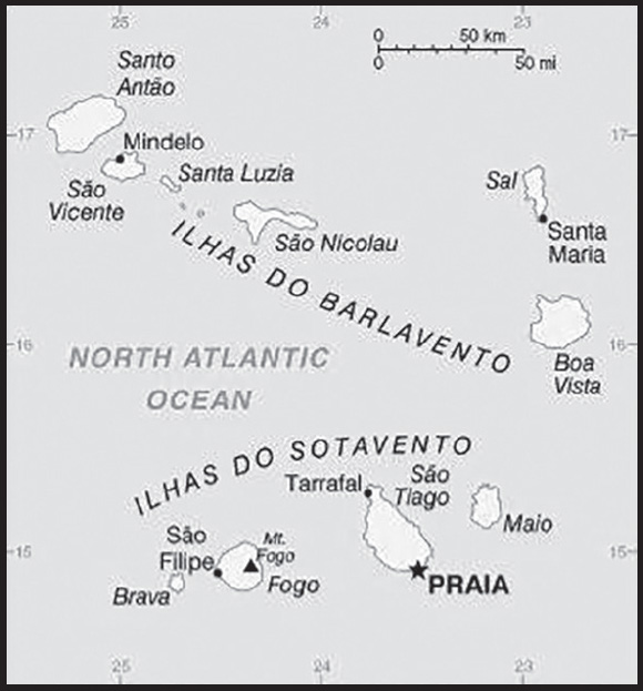
Population distribution: among the nine inhabited islands, population distribution is variable; islands in the east are very dry and are only sparsely settled to exploit their extensive salt deposits; the more southerly islands receive more precipitation and support larger populations, but agriculture and livestock grazing have damaged the soil fertility and vegetation; approximately half of the population lives on Sao Tiago Island, which is the location of the capital of Praia; Mindelo, on the northern island of Sao Vicente, also has a large urban population as shown in this population distribution map
Natural hazards: prolonged droughts; seasonal harmattan wind produces obscuring dust; volcanically and seismically active
volcanism: Fogo (2,829 m), which last erupted in 1995, is Cabo Verde’s only active volcano
Geography - note: strategic location 500 km from west coast of Africa near major north-south sea routes; important communications station; important sea and air refueling site; one of four North Atlantic archipelagos that make up Macaronesia; the others are Azores (Portugal), Canary Islands (Spain), and Madeira (Portugal)
PEOPLE AND SOCIETY
Population: 603,901 (2023 est.)
comparison ranking: 171
Nationality: noun: Cabo Verdean(s)
adjective: Cabo Verdean
Ethnic groups: Creole (Mulatto) 71%, African 28%, European 1%
Languages: Portuguese (official), Crioulo (a Portuguese-based Creole language with two main dialects spoken in Cabo Verde and in the Cabo Verdean diaspora worldwide)
Religions: Roman Catholic 77.3%, Protestant 4.6% (includes Church of the Nazarene 1.7%, Adventist 1.5%, Assembly of God 0.9%, Universal Kingdom of God 0.4%, and God and Love 0.1%), other Christian 3.4% (includes Christian Rationalism 1.9%, Jehovah’s Witness 1%, and New Apostolic 0.5%), Muslim 1.8%, other 1.3%, none 10.8%, unspecified 0.7% (2010 est.)
Demographic profile: Cabo Verde’s population descends from its first permanent inhabitants in the late 15th-century – a preponderance of West African slaves, a small share of Portuguese colonists, and even fewer Italians, Spaniards, and Portuguese Jews. Over the centuries, the country’s overall population size has fluctuated significantly, as recurring periods of famine and epidemics have caused high death tolls and emigration.
Labor migration historically reduced Cabo Verde’s population growth and still provides a key source of income through remittances. Expatriates probably outnumber Cabo Verde’s resident population, with most families having a member abroad. Cabo Verdeans have settled in the US, Europe, Africa, and South America. The largest diaspora community in New Bedford, Massachusetts, dating to the early 1800s, is a byproduct of the transatlantic whaling industry. Cabo Verdean men fleeing poverty at home joined the crews of US whaling ships that stopped in the islands. Many settled in New Bedford and stayed in the whaling or shipping trade, worked in the textile or cranberry industries, or operated their own transatlantic packet ships that transported compatriots to the US. Increased Cabo Verdean emigration to the US coincided with the gradual and eventually complete abolition of slavery in the archipelago in 1878.
During the same period, Portuguese authorities coerced Cabo Verdeans to go to Sao Tome and Principe and other Portuguese colonies in Africa to work as indentured laborers on plantations. In the 1920s, when the US implemented immigration quotas, Cabo Verdean emigration shifted toward Portugal, West Africa (Senegal), and South America (Argentina). Growing numbers of Cabo Verdean labor migrants headed to Western Europe in the 1960s and 1970s. They filled unskilled jobs in Portugal, as many Portuguese sought out work opportunities in the more prosperous economies of northwest Europe. Cabo Verdeans eventually expanded their emigration to the Netherlands, where they worked in the shipping industry. Migration to the US resumed under relaxed migration laws. Cabo Verdean women also began migrating to southern Europe to become domestic workers, a trend that continues today and has shifted the gender balance of Cabo Verdean emigration.
Emigration has declined in more recent decades due to the adoption of more restrictive migration policies in destination countries. Reduced emigration along with a large youth population, decreased mortality rates, and increased life expectancies, has boosted population growth, putting further pressure on domestic employment and resources. In addition, Cabo Verde has attracted increasing numbers of migrants in recent decades, consisting primarily of people from West Africa, Portuguese-speaking African countries, Portugal, and China. Since the 1990s, some West African migrants have used Cabo Verde as a stepping stone for illegal migration to Europe.
Age structure: 0-14 years: 26.68% (male 80,974/female 80,143)
15-64 years: 67.18% (male 198,503/female 207,205)
65 years and over: 6.14% (2023 est.) (male 14,099/female 22,977)
Dependency ratios: total dependency ratio: 47.2
youth dependency ratio: 39.2
elderly dependency ratio: 8
potential support ratio: 12.5 (2021 est.)
Median age: total: 26.8 years (2020)
male: 25.9 years
female: 27.6 years
comparison ranking: total 151
Population growth rate: 1.19% (2023 est.)
comparison ranking: 75
Birth rate: 18.19 births/1,000 population (2023 est.)
comparison ranking: 77
Death rate: 5.77 deaths/1,000 population (2023 est.)
comparison ranking: 166
Net migration rate: -0.57 migrant(s)/1,000 population (2023 est.)
comparison ranking: 126
Population distribution: among the nine inhabited islands, population distribution is variable; islands in the east are very dry and are only sparsely settled to exploit their extensive salt deposits; the more southerly islands receive more precipitation and support larger populations, but agriculture and livestock grazing have damaged the soil fertility and vegetation; approximately half of the population lives on Sao Tiago Island, which is the location of the capital of Praia; Mindelo, on the northern island of Sao Vicente, also has a large urban population as shown in this population distribution map
Urbanization: urban population: 68% of total population (2023)
rate of urbanization: 1.83% annual rate of change (2020-25 est.)
Major urban areas - population: 168,000 PRAIA (capital) (2018)
Sex ratio: at birth: 1.03 male(s)/female
0-14 years: 1.01 male(s)/female
15-64 years: 0.96 male(s)/female
65 years and over: 0.61 male(s)/female
total population: 0.95 male(s)/female (2023 est.)
Maternal mortality ratio: 42 deaths/100,000 live births (2020 est.)
comparison ranking: 101
Infant mortality rate: total: 22.96 deaths/1,000 live births (2023 est.)
male: 26.96 deaths/1,000 live births
female: 18.84 deaths/1,000 live births
comparison ranking: total 69
Life expectancy at birth: total population: 74.02 years (2023 est.)
male: 71.69 years
female: 76.41 years
comparison ranking: total population 145
Total fertility rate: 2.11 children born/woman (2023 est.)
comparison ranking: 92
Gross reproduction rate: 1.04 (2023 est.)
Contraceptive prevalence rate: 55.8% (2018)
Drinking water source: improved: urban: 100% of population
rural: 90% of population
total: 96.7% of population
unimproved: urban: 0% of population
rural: 10% of population
total: 3.3% of population (2020 est.)
Current health expenditure: 6% of GDP (2020)
Physicians density: 0.83 physicians/1,000 population (2018)
Hospital bed density: 2.1 beds/1,000 population
Sanitation facility access: improved: urban: 91.7% of population
rural: 73.3% of population
total: 85.6% of population
unimproved: urban: 8.3% of population
rural: 26.7% of population
total: 14.4% of population (2020 est.)
Obesity - adult prevalence rate: 11.8% (2016)
comparison ranking: 134
Alcohol consumption per capita: total: 4.7 liters of pure alcohol (2019 est.)
beer: 2.28 liters of pure alcohol (2019 est.)
wine: 1.82 liters of pure alcohol (2019 est.)
spirits: 0.6 liters of pure alcohol (2019 est.)
other alcohols: 0 liters of pure alcohol (2019 est.)
comparison ranking: total 86
Tobacco use: total: 11.4% (2020 est.)
male: 17.3% (2020 est.)
female: 5.4% (2020 est.)
comparison ranking: total 127
Currently married women (ages 15-49): 46.9% (2023 est.)
Education expenditures: 7.6% of GDP (2020 est.)
comparison ranking: 15
Literacy: definition: age 15 and over can read and write
total population: 90.8%
male: 94.2%
female: 87.4% (2021)
School life expectancy (primary to tertiary education): total: 13 years
male: 12 years
female: 13 years (2018)
Youth unemployment rate (ages 15-24): total: 34.3% (2021 est.)
male: 29.9%
female: 40.7%
comparison ranking: total 27
ENVIRONMENT
Environment - current issues: deforestation due to demand for firewood; water shortages; prolonged droughts and improper use of land (overgrazing, crop cultivation on hillsides lead to desertification and erosion); environmental damage has threatened several species of birds and reptiles; illegal beach sand extraction; overfishing
Environment - international agreements: party to: Biodiversity, Climate Change, Climate Change-Kyoto Protocol, Climate Change-Paris Agreement, Comprehensive Nuclear Test Ban, Desertification, Endangered Species, Environmental Modification, Hazardous Wastes, Law of the Sea, Marine Dumping-London Convention, Nuclear Test Ban, Ozone Layer Protection, Ship Pollution, Wetlands
signed, but not ratified: none of the selected agreements
Climate: temperate; warm, dry summer; precipitation meager and erratic
Land use: agricultural land: 18.6% (2018 est.)
arable land: 11.7% (2018 est.)
permanent crops: 0.7% (2018 est.)
permanent pasture: 6.2% (2018 est.)
forest: 21% (2018 est.)
other: 60.4% (2018 est.)
Urbanization: urban population: 68% of total population (2023)
rate of urbanization: 1.83% annual rate of change (2020-25 est.)
Revenue from forest resources: 0.38% of GDP (2018 est.)
comparison ranking: 72
Revenue from coal: 0% of GDP (2018 est.)
comparison ranking: 125
Air pollutants: particulate matter emissions: 31.08 micrograms per cubic meter (2019 est.)
carbon dioxide emissions: 0.54 megatons (2016 est.)
methane emissions: 0.13 megatons (2020 est.)
Waste and recycling: municipal solid waste generated annually: 132,555 tons (2012 est.)
Total water withdrawal: municipal: 1.6 million cubic meters (2017 est.)
industrial: 400,000 cubic meters (2017 est.)
agricultural: 30 million cubic meters (2020 est.)
Total renewable water resources: 300 million cubic meters (2020 est.)
GOVERNMENT
Country name: conventional long form: Republic of Cabo Verde
conventional short form: Cabo Verde
local long form: Republica de Cabo Verde
local short form: Cabo Verde
etymology: the name derives from Cap-Vert (Green Cape) on the Senegalese coast, the westernmost point of Africa and the nearest mainland to the islands
Government type: parliamentary republic
Capital: name: Praia
geographic coordinates: 14 55 N, 23 31 W
time difference: UTC-1 (4 hours ahead of Washington, DC, during Standard Time)
etymology: the earlier Portuguese name was Villa de Praia (“Village of the Beach”); it became just Praia in 1974 (prior to full independence in 1975)
Administrative divisions: 22 municipalities (concelhos, singular - concelho); Boa Vista, Brava, Maio, Mosteiros, Paul, Porto Novo, Praia, Ribeira Brava, Ribeira Grande, Ribeira Grande de Santiago, Sal, Santa Catarina, Santa Catarina do Fogo, Santa Cruz, Sao Domingos, Sao Filipe, Sao Lourenco dos Orgaos, Sao Miguel, Sao Salvador do Mundo, Sao Vicente, Tarrafal, Tarrafal de Sao Nicolau
Independence: 5 July 1975 (from Portugal)
National holiday: Independence Day, 5 July (1975)
Constitution: history: previous 1981; latest effective 25 September 1992
amendments: proposals require support of at least four fifths of the active National Assembly membership; amendment drafts require sponsorship of at least one third of the active Assembly membership; passage requires at least two-thirds majority vote by the Assembly membership; constitutional sections, including those on national independence, form of government, political pluralism, suffrage, and human rights and liberties, cannot be amended; revised 1995, 1999, 2010
Legal system: civil law system of Portugal
International law organization participation: has not submitted an ICJ jurisdiction declaration; accepts ICCt jurisdiction
Citizenship: citizenship by birth: no
citizenship by descent only: at least one parent must be a citizen of Cabo Verde
dual citizenship recognized: yes
residency requirement for naturalization: 5 years
Suffrage: 18 years of age; universal
Executive branch: chief of state: President Jose Maria Pereira NEVES (since 9 November 2021)
head of government: Prime Minister Jose Ulisses CORREIA e SILVA (since 22 April 2016)
cabinet: Council of Ministers appointed by the president on the recommendation of the prime minister
elections/appointments: president directly elected by absolute majority popular vote in 2 rounds if needed for a 5-year term (eligible for a second term); election last held on 17 October 2021 (next to be held in October 2026); prime minister nominated by the National Assembly and appointed by the president
election results:
2020: Jose Maria Pereira NEVES elected president; percent of vote - Jose Maria Pereira NEVES (PAICV) 51.7%, Carlos VEIGA (MPD) 42.4%, Casimiro DE PINA (Independent) 1.8%, Fernando Rocha DELGADO (Independent) 1.4%, Helio SANCHES (independent) 1.14%, Gilson ALVES (independent) 0.8%, Joaquim MONTEIRO (independent) 3.4%
2016: Jorge Carlos FONSECA reelected president; percent of vote - Jorge Carlos FONSECA (MPD) 74.1%, Albertino GRACA (independent) 22.5%, other 3.4%
Legislative branch: description: unicameral National Assembly or Assembleia Nacional (72 seats; members directly elected in multi-seat constituencies by proportional representation vote; members serve 5-year terms)
elections: last held on 18 April 2021 (next to be held in April 2026)
election results: percent of vote by party MPD 50.2%, PAICV 39.6%, UCID 9.0%, other 1.2%; seats by party - MPD 38, PAICV 30, UCID 4; composition as of October 2023 - men 42, women 30, percent of women 41.7%
Judicial branch: highest court(s): Supreme Court of Justice (consists of the chief justice and at least 7 judges and organized into civil, criminal, and administrative sections)
judge selection and term of office: judge appointments - 1 by the president of the republic, 1 elected by the National Assembly, and 3 by the Superior Judicial Council (SJC), a 16-member independent body chaired by the chief justice and includes the attorney general, 8 private citizens, 2 judges, 2 prosecutors, the senior legal inspector of the Attorney General’s office, and a representative of the Ministry of Justice; chief justice appointed by the president of the republic from among peers of the Supreme Court of Justice and in consultation with the SJC; judges appointed for life
subordinate courts: appeals courts, first instance (municipal) courts; audit, military, and fiscal and customs courts
Political parties and leaders: African Party for Independence of Cabo Verde or PAICV [Jose Maria Pereira NEVES]
Democratic and Independent Cabo Verdean Union or UCID [João DOS SANTOS LUIS]
Democratic Christian Party or PDC [Manuel RODRIGUES]
Democratic Renewal Party or PRD [Victor FIDALGO]
Movement for Democracy or MPD [Ulisses CORREIA E SILVA]
Party for Democratic Convergence or PCD [Dr. Eurico MONTEIRO]
Party of Work and Solidarity or PTS [Anibal MEDINA]
Social Democratic Party or PSD [Joao ALEM]
International organization participation: ACP, AfDB, AOSIS, AU, CD, CPLP, ECOWAS, FAO, G-77, IAEA, IBRD, ICAO, ICCt (signatory), ICRM, IDA, IFAD, IFC, IFRCS, ILO, IMF, IMO, Interpol, IOC, IOM, IPU, ITSO, ITU, ITUC (NGOs), MIGA, NAM, OIF, OPCW, UN, UNCTAD, UNESCO, UNIDO, Union Latina, UNWTO, UPU, WCO, WHO, WIPO, WMO, WTO
Diplomatic representation in the US: chief of mission: Ambassador Jose Luis do Livramento MONTEIRO ALVES DE BRITO (since 23 December 2020)
chancery: 3415 Massachusetts Avenue NW, Washington, DC 20007
telephone: [1] (202) 965-6820
FAX: [1] (202) 965-1207
email address and website:
consulate(s) general: Boston
Diplomatic representation from the US: chief of mission: Ambassador John “Jeff” DAIGLE (since 10 September 2019)
embassy: Rua Abilio Macedo 6, Praia
mailing address: 2460 Praia Place, Washington DC 20521-2460
telephone: [238] 260-8900
FAX: [238] 261-1355
email address and website:
Flag description: five unequal horizontal bands; the top-most band of blue - equal to one half the width of the flag - is followed by three bands of white, red, and white, each equal to 1/12 of the width, and a bottom stripe of blue equal to one quarter of the flag width; a circle of 10 yellow, five-pointed stars is centered on the red stripe and positioned 3/8 of the length of the flag from the hoist side; blue stands for the sea and the sky, the circle of stars represents the 10 major islands united into a nation, the stripes symbolize the road to formation of the country through peace (white) and effort (red)
National symbol(s): ten, five-pointed, yellow stars; national colors: blue, white, red, yellow
National anthem: name: “Cantico da Liberdade” (Song of Freedom)
lyrics/music: Amilcar Spencer LOPES/Adalberto Higino Tavares SILVA
note: adopted 1996
National heritage: total World Heritage Sites: 1 (cultural)
selected World Heritage Site locales: Cidade Velha; Historic Center of Ribeira Grande
ECONOMY
Economic overview: tourism-dominated economy benefits from the country’s relative close proximity to Europe; 2009 Financial Crisis halted economic growth for seven years; leveraging export-based growth; COVID-19 decimated economic growth and recovery; high external debt
Real GDP (purchasing power parity): $3.595 billion (2021 est.)
$3.361 billion (2020 est.)
$3.944 billion (2019 est.)
note: data are in 2017 dollars
comparison ranking: 187
Real GDP growth rate: 6.95% (2021 est.)
-14.78% (2020 est.)
5.67% (2019 est.)
comparison ranking: 58
Real GDP per capita: $6,100 (2021 est.)
$5,800 (2020 est.)
$6,800 (2019 est.)
note: data are in 2017 dollars
comparison ranking: 162
GDP (official exchange rate): $1.971 billion (2019 est.)
Inflation rate (consumer prices): 1.86% (2021 est.)
0.61% (2020 est.)
1.11% (2019 est.)
comparison ranking: 162
Credit ratings: Fitch rating: B- (2020)
Standard & Poors rating: B (2013)
note: The year refers to the year in which the current credit rating was first obtained.
GDP - composition, by sector of origin: agriculture: 8.9% (2017 est.)
industry: 17.5% (2017 est.)
services: 73.7% (2017 est.)
comparison rankings: services 56; industry 167; agriculture 96
GDP - composition, by end use: household consumption: 50.1% (2017 est.)
government consumption: 18.3% (2017 est.)
investment in fixed capital: 32.2% (2017 est.)
investment in inventories: 1.9% (2017 est.)
exports of goods and services: 48.6% (2017 est.)
imports of goods and services: -51.1% (2017 est.)
Agricultural products: sugar cane, tomatoes, bananas, cabbages, coconuts, cassava, pulses, vegetables, milk, goat milk
Industries: food and beverages, fish processing, shoes and garments, salt mining, ship repair
Industrial production growth rate: 11.76% (2021 est.)
comparison ranking: 22
Labor force: 234,300 (2021 est.)
comparison ranking: 172
Unemployment rate: 15.42% (2021 est.)
15.31% (2020 est.)
12.22% (2019 est.)
comparison ranking: 34
Youth unemployment rate (ages 15-24): total: 34.3% (2021 est.)
male: 29.9%
female: 40.7%
comparison ranking: total 27
Population below poverty line: 35% (2015 est.)
Gini Index coefficient - distribution of family income: 42.4 (2015 est.)
comparison ranking: 38
Household income or consumption by percentage share: lowest 10%: 1.9%
highest 10%: 40.6% (2000)
Budget: revenues: $583 million (2019 est.)
expenditures: $619 million (2019 est.)
Budget surplus (+) or deficit (-): -3% (of GDP) (2017 est.)
comparison ranking: 131
Public debt: 125.8% of GDP (2017 est.)
127.6% of GDP (2016 est.)
comparison ranking: 12
Taxes and other revenues: 20.09% (of GDP) (2017 est.)
comparison ranking: 90
Fiscal year: calendar year
Current account balance: -$256.181 million (2021 est.)
-$284.109 million (2020 est.)
$6.477 million (2019 est.)
comparison ranking: 103
Exports: $459.923 million (2021 est.)
$415.242 million (2020 est.)
$1.006 billion (2019 est.)
note: Data are in current year dollars and do not include illicit exports or re-exports.
comparison ranking: 189
Exports - partners: Spain 65%, Portugal 14%, Italy 8% (2019)
Exports - commodities: tuna, mackerel, aircraft, other processed and frozen fish, postage stamps and title bond paper documents, mollusks (2021)
Imports: $1.117 billion (2021 est.) note: data are in current year dollars
$1.008 billion (2020 est.) note: data are in current year dollars
$1.287 billion (2019 est.) note: data are in current year dollars
comparison ranking: 186
Imports - partners: Portugal 36%, Netherlands 16%, Spain 11%, China 6% (2019)
Imports - commodities: refined petroleum, delivery trucks, coal tar oil, cars, rice (2019)
Reserves of foreign exchange and gold: $769.65 million (31 December 2021 est.)
$735.085 million (31 December 2020 est.)
$737.991 million (31 December 2019 est.)
comparison ranking: 157
Debt - external: $1.713 billion (31 December 2017 est.)
$1.688 billion (31 December 2016 est.)
comparison ranking: 155
Exchange rates: Cabo Verdean escudos (CVE) per US dollar -
Exchange rates:: 93.218 (2021 est.)
96.796 (2020 est.)
98.495 (2019 est.)
93.414 (2018 est.)
97.807 (2017 est.)
ENERGY
Electricity access: electrification - total population: 95.2% (2021)
electrification - urban areas: 94.8% (2021)
electrification - rural areas: 96.8% (2021)
Electricity: installed generating capacity: 205,000 kW (2020 est.)
consumption: 436.854 million kWh (2019 est.)
exports: 0 kWh (2019 est.)
imports: 0 kWh (2019 est.)
transmission/distribution losses: 32.146 million kWh (2019 est.)
comparison rankings: installed generating capacity 170; transmission/distribution losses 177; imports 171; exports 163; consumption 175
Electricity generation sources: fossil fuels: 80.2% of total installed capacity (2020 est.)
solar: 2% of total installed capacity (2020 est.)
wind: 17.8% of total installed capacity (2020 est.)
Petroleum: total petroleum production: 0 bbl/day (2021 est.)
refined petroleum consumption: 6,500 bbl/day (2019 est.)
crude oil and lease condensate exports: 0 bbl/day (2018 est.)
crude oil and lease condensate imports: 0 bbl/day (2018 est.)
crude oil estimated reserves: 0 barrels (2021 est.)
Refined petroleum products - imports: 5,607 bbl/day (2015 est.)
comparison ranking: 166
Carbon dioxide emissions: 1.002 million metric tonnes of CO2 (2019 est.)
from petroleum and other liquids: 1.002 million metric tonnes of CO2 (2019 est.)
comparison ranking: total emissions 173
Energy consumption per capita: 26.539 million Btu/person (2019 est.)
comparison ranking: 128
COMMUNICATIONS
Telephones - fixed lines: total subscriptions: 53,586 (2021 est.)
subscriptions per 100 inhabitants: 9 (2021 est.)
comparison ranking: total subscriptions 154
Telephones - mobile cellular: total subscriptions: 590,171 (2021 est.)
subscriptions per 100 inhabitants: 100 (2021 est.)
comparison ranking: total subscriptions 173
Telecommunication systems: general assessment: LTE reaches almost 40% of the population; regulator awards commercial 4G licenses and starts 5G pilot; govt. extends USD 25 million for submarine fiber-optic cable project linking Africa to Portugal and Brazil (2020)
domestic: 9 per 100 fixed-line teledensity and nearly 100 per 100 mobile-cellular (2021)
international: country code - 238; landing points for the Atlantis-2, EllaLink, Cabo Verde Telecom Domestic Submarine Cable Phase 1, 2, 3 and WACS fiber-optic transatlantic telephone cable that provides links to South America, Africa, and Europe; HF radiotelephone to Senegal and Guinea-Bissau; satellite earth station - 1 Intelsat (Atlantic Ocean) (2019)
Broadcast media: state-run TV and radio broadcast network plus a growing number of private broadcasters; Portuguese public TV and radio services for Africa are available; transmissions of a few international broadcasters are available (2019)
Internet country code: .cv
Internet users: total: 413,000 (2021 est.)
percent of population: 70% (2021 est.)
comparison ranking: total 171
Broadband - fixed subscriptions: total: 24,839 (2020 est.)
subscriptions per 100 inhabitants: 5 (2020 est.)
comparison ranking: total 160
TRANSPORTATION
National air transport system: number of registered air carriers: 2 (2020)
inventory of registered aircraft operated by air carriers: 5
annual passenger traffic on registered air carriers: 140,429 (2018)
annual freight traffic on registered air carriers: 1,728,152 (2015) mt-km
Civil aircraft registration country code prefix: D4
Airports: 9 (2021)
comparison ranking: total 156
Airports - with paved runways: 9
note: paved runways have a concrete or asphalt surface but not all have facilities for refueling, maintenance, or air traffic control; the length of a runway required for aircraft to safely operate depends on a number of factors including the type of aircraft, the takeoff weight (including passengers, cargo, and fuel), engine types, flap settings, landing speed, elevation of the airport, and average maximum daily air temperature; paved runways can reach a length of 5,000 m (16,000 ft.), but the “typical” length of a commercial airline runway is between 2,500-4,000 m (8,000-13,000 ft.)
Roadways: total: 1,350 km (2013)
paved:932 km (2013)
unpaved:418 km (2013)
comparison ranking: total 176
Merchant marine: total: 47 (2022)
by type: general cargo 16, oil tanker 3, other 28
comparison ranking: total 120
Ports and terminals: major seaport(s): Porto Grande
MILITARY AND SECURITY
Military and security forces: Cabo Verdean Armed Forces (FACV): Army (also called the National Guard, GN; includes a small air component), Cabo Verde Coast Guard (Guardia Costeira de Cabo Verde, GCCV) (2023)
note: the National Police are under the Ministry of Internal Affairs
Military expenditures: 0.5% of GDP (2022 est.)
0.5% of GDP (2021 est.)
0.5% of GDP (2020 est.)
0.5% of GDP (2019 est.)
0.5% of GDP (2018 est.)
comparison ranking: 161
Military and security service personnel strengths: the military has approximately 1,000-1,200 personnel (2023)
Military equipment inventories and acquisitions: the FACV has a limited amount of mostly dated and second-hand equipment, largely from China, some European countries, and the former Soviet Union (2023)
Military service age and obligation: 18-35 years of age for male and female selective compulsory military service; 24-month conscript service obligation; 17 years of age for voluntary service (with parental consent) (2023)
Military - note: the FACV/National Guard is mostly a ground force with 2 infantry battalions and a small air component with a maritime patrol squadron; the Coast Guard had a few coastal patrol craft and patrol boats (2023)
TRANSNATIONAL ISSUES
Disputes - international: none identified
Refugees and internally displaced persons: stateless persons: 115 (2022)
Illicit drugs: narcotraffickers transit cocaine, cannabis, and other drugs to Africa and Europe; domestic trafficking contributes to increased consumption of illicit substances;
INTRODUCTION
Background: Most Cambodians consider themselves to be Khmers, descendants of the Angkor Empire that extended over much of Southeast Asia and reached its zenith between the 10th and 13th centuries. Attacks by the Thai and Cham (from present-day Vietnam) weakened the empire, ushering in a long period of decline. The king placed the country under French protection in 1863, and it became part of French Indochina in 1887. Following the Japanese occupation in World War II, Cambodia gained full independence from France in 1953. In April 1975, after a seven-year struggle, communist Khmer Rouge forces captured Phnom Penh and evacuated all cities and towns. At least 1.5 million Cambodians died from execution, forced hardships, or starvation during the Khmer Rouge regime under POL POT. A December 1978 Vietnamese invasion drove the Khmer Rouge into the countryside, began a 10-year Vietnamese occupation, and touched off 20 years of civil war.
The 1991 Paris Peace Accords mandated democratic elections and a cease-fire, which was not fully respected by the Khmer Rouge. UN-sponsored elections in 1993 helped restore some semblance of normalcy under a coalition government. Factional fighting in 1997 ended the first coalition government, but a second round of national elections in 1998 led to the formation of another coalition government and renewed political stability. The remaining elements of the Khmer Rouge surrendered in early 1999. Some of the surviving Khmer Rouge leaders were tried for crimes against humanity by a hybrid UN-Cambodian tribunal supported by international assistance. In 2018, the tribunal heard its final cases, but it remains in operation to hear appeals. Elections in July 2003 were relatively peaceful, but it took one year of negotiations between contending political parties before a coalition government was formed. In October 2004, King Norodom SIHANOUK abdicated the throne and his son, Prince Norodom SIHAMONI, was selected to succeed him. Local (Commune Council) elections were held in Cambodia in 2012, with little of the violence that preceded prior elections. National elections in July 2013 were disputed, with the opposition - the Cambodia National Rescue Party (CNRP) - boycotting the National Assembly. The political impasse was ended nearly a year later, with the CNRP agreeing to enter parliament in exchange for commitments by the ruling Cambodian People’s Party (CPP) to undertake electoral and legislative reforms. The CNRP made further gains in local commune elections in June 2017, accelerating sitting Prime Minister HUN SEN’s efforts to marginalize the CNRP before national elections in 2018. HUN SEN arrested CNRP President KEM SOKHA in September 2017. The Supreme Court dissolved the CNRP in November 2017 and banned its leaders from participating in politics for at least five years. The CNRP’s seats in the National Assembly were redistributed to smaller, less influential opposition parties, while all of the CNRP’s 5,007 seats in the commune councils throughout the country were reallocated to the CPP. With the CNRP banned, the CPP swept the 2018 national elections, winning all 125 National Assembly seats and effectively turning the country into a one-party state.
Cambodia has strong and growing economic and political ties with its large neighbor to the north, China. More than 53% of foreign investment in the country in 2021 came from China, and Beijing has provided over $15 billion in financial assistance since the 1990s. China accounted for 443 percent of Cambodia’s foreign debt in 2021. The CPP also partly sees Chinese support as a counterbalance to Thailand and Vietnam and to international criticism of the CPP’s human rights and antidemocratic record.
GEOGRAPHY
Location: Southeastern Asia, bordering the Gulf of Thailand, between Thailand, Vietnam, and Laos
Geographic coordinates: 13 00 N, 105 00 E
Map references: Southeast Asia
Area: total: 181,035 sq km
land: 176,515 sq km
water: 4,520 sq km
comparison ranking: total 90
Area - comparative: one and a half times the size of Pennsylvania; slightly smaller than Oklahoma
Land boundaries: total: 2,530 km
border countries (3): Laos 555 km; Thailand 817 km; Vietnam 1158 km
Coastline: 443 km
Maritime claims: territorial sea: 12 nm
contiguous zone: 24 nm
exclusive economic zone: 200 nm
continental shelf: 200 nm
Climate: tropical; rainy, monsoon season (May to November); dry season (December to April); little seasonal temperature variation
Terrain: mostly low, flat plains; mountains in southwest and north
Elevation: highest point: Phnum Aoral 1,810 m
lowest point: Gulf of Thailand 0 m
mean elevation: 126 m
Natural resources: oil and gas, timber, gemstones, iron ore, manganese, phosphates, hydropower potential, arable land
Land use: agricultural land: 32.1% (2018 est.)
arable land: 22.7% (2018 est.)
permanent crops: 0.9% (2018 est.)
permanent pasture: 8.5% (2018 est.)
forest: 56.5% (2018 est.)
other: 11.4% (2018 est.)
Irrigated land: 3,540 sq km (2012)
Major lakes (area sq km): fresh water lake(s): Tonle Sap - 2,700-16,000 sq km
Major rivers (by length in km): Mekong (shared with China [s], Burma, Thailand, Laos, and Vietnam [m]) - 4,350 km
note – [s] after country name indicates river source; [m] after country name indicates river mouth
Major watersheds (area sq km): Pacific Ocean drainage: Mekong (805,604 sq km)
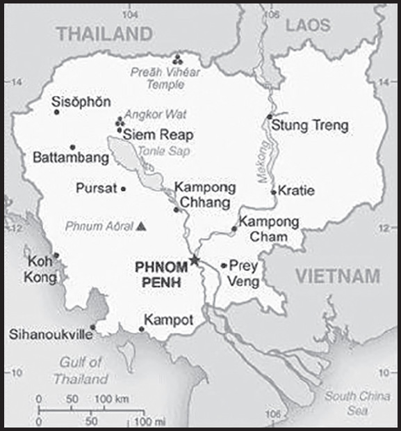
Population distribution: population concentrated in the southeast, particularly in and around the capital of Phnom Penh; further distribution is linked closely to the Tonle Sap and Mekong Rivers
Natural hazards: monsoonal rains (June to November); flooding; occasional droughts
Geography - note: a land of paddies and forests dominated by the Mekong River and Tonle Sap (Southeast Asia’s largest freshwater lake)
PEOPLE AND SOCIETY
Population: 16,891,245 (2023 est.)
comparison ranking: 72
Nationality: noun: Cambodian(s)
adjective: Cambodian
Ethnic groups: Khmer 95.4%, Cham 2.4%, Chinese 1.5%, other 0.7% (2019-20 est.)
Languages: Khmer (official) 95.8%, minority languages 2.9%, Chinese 0.6%, Vietnamese 0.5%, other 0.2% (2019 est.)
major-language sample(s):


(Khmer)
Religions: Buddhist (official) 97.1%, Muslim 2%, Christian 0.3%, other 0.5% (2019 est.)
Demographic profile: Cambodia is a predominantly rural country with among the most ethnically and religiously homogenous populations in Southeast Asia: more than 95% of its inhabitants are Khmer and more than 95% are Buddhist. The population’s size and age structure shrank and then rebounded during the 20th century as a result of conflict and mass death. During the Khmer Rouge regime between 1975 and 1979 as many as 1.5 to 2 million people are estimated to have been killed or died as a result of starvation, disease, or overwork – a loss of about 25% of the population. At the same time, emigration was high, and the fertility rate sharply declined. In the 1980s, after the overthrow of the Khmer Rouge, fertility nearly doubled and reached pre-Khmer Rouge levels of close to 7 children per woman, reflecting in part higher infant survival rates. The baby boom was followed by a sustained fertility decline starting in the early 1990s, eventually decreasing from 3.8 in 2000 to 2.9 in 2010, although the rate varied by income, education, and rural versus urban location. Despite continuing fertility reduction, Cambodia still has a youthful population that is likely to maintain population growth through population momentum. Improvements have also been made in mortality, life expectancy, and contraceptive prevalence, although reducing malnutrition among children remains stalled. Differences in health indicators are pronounced between urban and rural areas, which experience greater poverty.
Cambodia is predominantly a country of migration, driven by the search for work, education, or marriage. Internal migration is more prevalent than international migration, with rural to urban migration being the most common, followed by rural to rural migration. Urban migration focuses on the pursuit of unskilled or semi-skilled jobs in Phnom Penh, with men working mainly in the construction industry and women working in garment factories. Most Cambodians who migrate abroad do so illegally using brokers because it is cheaper and faster than through formal channels, but doing so puts them at risk of being trafficked for forced labor or sexual exploitation. Young Cambodian men and women migrate short distances across the Thai border using temporary passes to work in agriculture, while others migrate long distances primarily into Thailand and Malaysia for work in agriculture, fishing, construction, manufacturing, and domestic service. Cambodia was a refugee sending country in the 1970s and 1980s as a result of the brutality of the Khmer Rouge regime, its ousting by the Vietnamese invasion, and the resultant civil war. Tens of thousands of Cambodians fled to Thailand; more than 100,000 were resettled in the US in the 1980s. Cambodia signed a multi-million dollar agreement with Australia in 2014 to voluntarily resettle refugees seeking shelter in Australia. However, the deal has proven to be a failure because of poor conditions and a lack of support services for the few refugees willing to accept the offer.
Age structure: 0-14 years: 29.47% (male 2,518,910/female 2,459,235)
15-64 years: 65.39% (male 5,362,180/female 5,682,247)
65 years and over: 5.14% (2023 est.) (male 308,931/female 559,742)
Dependency ratios: total dependency ratio: 53.4
youth dependency ratio: 45
elderly dependency ratio: 8.5
potential support ratio: 11.8 (2021 est.)
Median age: total: 26.4 years (2020)
male: 25.6 years
female: 27.2 years
comparison ranking: total 153
Population growth rate: 1.04% (2023 est.)
comparison ranking: 90
Birth rate: 18.75 births/1,000 population (2023 est.)
comparison ranking: 74
Death rate: 5.7 deaths/1,000 population (2023 est.)
comparison ranking: 171
Net migration rate: -2.67 migrant(s)/1,000 population (2023 est.)
comparison ranking: 176
Population distribution: population concentrated in the southeast, particularly in and around the capital of Phnom Penh; further distribution is linked closely to the Tonle Sap and Mekong Rivers
Urbanization: urban population: 25.6% of total population (2023)
rate of urbanization: 3.06% annual rate of change (2020-25 est.)
Major urban areas - population: 2.281 million PHNOM PENH (capital) (2023)
Sex ratio: at birth: 1.05 male(s)/female
0-14 years: 1.02 male(s)/female
15-64 years: 0.94 male(s)/female
65 years and over: 0.55 male(s)/female
total population: 0.94 male(s)/female (2023 est.)
Mother’s mean age at first birth: 23.3 years (2021-22 est.)
note: data represents median age at first birth among women 25-49
Maternal mortality ratio: 218 deaths/100,000 live births (2020 est.)
comparison ranking: 42
Infant mortality rate: total: 28.75 deaths/1,000 live births (2023 est.)
male: 32.22 deaths/1,000 live births
female: 25.12 deaths/1,000 live births
comparison ranking: total 54
Life expectancy at birth: total population: 71.03 years (2023 est.)
male: 69.17 years
female: 72.97 years
comparison ranking: total population 168
Total fertility rate: 2.2 children born/woman (2023 est.)
comparison ranking: 84
Gross reproduction rate: 1.08 (2023 est.)
Contraceptive prevalence rate: 56.3% (2014)
Drinking water source: improved: urban: 99.3% of population
rural: 80.6% of population
total: 85.1% of population
unimproved: urban: 0.7% of population
rural: 19.4% of population
total: 14.9% of population (2020 est.)
Current health expenditure: 7.5% of GDP (2020)
Physicians density: 0.19 physicians/1,000 population (2014)
Hospital bed density: 1.9 beds/1,000 population (2016)
Sanitation facility access: improved: urban: 100% of population
rural: 69.3% of population
total: 76.8% of population
unimproved: urban: 0% of population
rural: 30.7% of population
total: 23.2% of population (2020 est.)
Major infectious diseases: degree of risk: very high (2023)
food or waterborne diseases: bacterial diarrhea, hepatitis A, and typhoid fever
vectorborne diseases: dengue fever, Japanese encephalitis, and malaria
animal contact diseases: Rabies
Obesity - adult prevalence rate: 3.9% (2016)
comparison ranking: 188
Alcohol consumption per capita: total: 4.56 liters of pure alcohol (2019 est.)
beer: 4.12 liters of pure alcohol (2019 est.)
wine: 0.03 liters of pure alcohol (2019 est.)
spirits: 0.41 liters of pure alcohol (2019 est.)
other alcohols: 0 liters of pure alcohol (2019 est.)
comparison ranking: total 87
Tobacco use: total: 21.1% (2020 est.)
male: 36.1% (2020 est.)
female: 6% (2020 est.)
comparison ranking: total 79
Children under the age of 5 years underweight: 16.3% (2022)
comparison ranking: 29
Currently married women (ages 15-49): 66.4% (2023 est.)
Education expenditures: 3.1% of GDP (2020 est.)
comparison ranking: 155
Literacy: definition: age 15 and over can read and write
total population: 83.9%
male: 88.4%
female: 79.8% (2021)
Youth unemployment rate (ages 15-24): total: 1.8% (2021 est.)
male: 1.6%
female: 2.1%
comparison ranking: total 201
ENVIRONMENT
Environment - current issues: illegal logging activities throughout the country and strip mining for gems in the western region along the border with Thailand have resulted in habitat loss and declining biodiversity (in particular, destruction of mangrove swamps threatens natural fisheries); soil erosion; in rural areas, most of the population does not have access to potable water; declining fish stocks because of illegal fishing and overfishing; coastal ecosystems choked by sediment washed loose from deforested areas inland
Environment - international agreements: party to: Biodiversity, Climate Change, Climate Change-Kyoto Protocol, Climate Change-Paris Agreement, Comprehensive Nuclear Test Ban, Desertification, Endangered Species, Hazardous Wastes, Marine Life Conservation, Ozone Layer Protection, Ship Pollution, Tropical Timber 2006, Wetlands, Whaling
signed, but not ratified: Law of the Sea
Climate: tropical; rainy, monsoon season (May to November); dry season (December to April); little seasonal temperature variation
Land use: agricultural land: 32.1% (2018 est.)
arable land: 22.7% (2018 est.)
permanent crops: 0.9% (2018 est.)
permanent pasture: 8.5% (2018 est.)
forest: 56.5% (2018 est.)
other: 11.4% (2018 est.)
Urbanization: urban population: 25.6% of total population (2023)
rate of urbanization: 3.06% annual rate of change (2020-25 est.)
Revenue from forest resources: 0.84% of GDP (2018 est.)
comparison ranking: 57
Revenue from coal: 0% of GDP (2018 est.)
comparison ranking: 87
Air pollutants: particulate matter emissions: 17.8 micrograms per cubic meter (2019 est.)
carbon dioxide emissions: 9.92 megatons (2016 est.)
methane emissions: 14.88 megatons (2020 est.)
Waste and recycling: municipal solid waste generated annually: 1.089 million tons (2014 est.)
Major lakes (area sq km): fresh water lake(s): Tonle Sap - 2,700-16,000 sq km
Major rivers (by length in km): Mekong (shared with China [s], Burma, Thailand, Laos, and Vietnam [m]) - 4,350 km
note – [s] after country name indicates river source; [m] after country name indicates river mouth
Major watersheds (area sq km): Pacific Ocean drainage: Mekong (805,604 sq km)
Total water withdrawal: municipal: 100 million cubic meters (2020 est.)
industrial: 30 million cubic meters (2020 est.)
agricultural: 2.05 billion cubic meters (2020 est.)
Total renewable water resources: 476.1 billion cubic meters (2020 est.)
GOVERNMENT
Country name: conventional long form: Kingdom of Cambodia
conventional short form: Cambodia
local long form: Preahreacheanachakr Kampuchea (phonetic transliteration)
local short form: Kampuchea
former: Khmer Republic, Democratic Kampuchea, People’s Republic of Kampuchea, State of Cambodia
etymology: the English name Cambodia is an anglicization of the French Cambodge, which is the French transliteration of the native name Kampuchea
Government type: parliamentary constitutional monarchy
Capital: name: Phnom Penh
geographic coordinates: 11 33 N, 104 55 E
time difference: UTC+7 (12 hours ahead of Washington, DC, during Standard Time)
etymology: Phnom Penh translates as “Penh’s Hill” in Khmer; the city takes its name from the present Wat Phnom (Hill Temple), the tallest religious structure in the city, whose establishment, according to legend, was inspired in the 14th century by a pious nun, Daun PENH
Administrative divisions: 24 provinces (khett, singular and plural) and 1 municipality (krong, singular and plural)
provinces: Banteay Meanchey, Battambang, Kampong Cham, Kampong Chhnang, Kampong Speu, Kampong Thom, Kampot, Kandal, Kep, Koh Kong, Kratie, Mondolkiri, Oddar Meanchey, Pailin, Preah Sihanouk, Preah Vihear, Prey Veng, Pursat, Ratanakiri, Siem Reap, Stung Treng, Svay Rieng, Takeo, Tbong Khmum
municipalities: Phnom Penh (Phnum Penh)
Independence: 9 November 1953 (from France)
National holiday: Independence Day, 9 November (1953)
Constitution: history: previous 1947; latest promulgated 21 September 1993
amendments: proposed by the monarch, by the prime minister, or by the president of the National Assembly if supported by one fourth of the Assembly membership; passage requires two-thirds majority of the Assembly membership; constitutional articles on the multiparty democratic form of government and the monarchy cannot be amended; amended several times, latest 2022
Legal system: civil law system (influenced by the UN Transitional Authority in Cambodia) customary law, Communist legal theory, and common law
International law organization participation: accepts compulsory ICJ jurisdiction with reservations; accepts ICCt jurisdiction
Citizenship: citizenship by birth: no
citizenship by descent only: at least one parent must be a citizen of Cambodia
dual citizenship recognized: yes
residency requirement for naturalization: 7 years
Suffrage: 18 years of age; universal
Executive branch: chief of state: King Norodom SIHAMONI (since 29 October 2004)
head of government: Prime Minister HUN MANET (since 22 August 2023); note - MANET succeeded his father, HUN SEN, who had been prime minister since 1985
cabinet: Council of Ministers named by the prime minister and appointed by the monarch
elections/appointments: monarch chosen by the 9-member Royal Council of the Throne from among all eligible males of royal descent; following legislative elections, a member of the majority party or majority coalition named prime minister by the Chairman of the National Assembly and appointed by the monarch
Legislative branch: description: bicameral Parliament of Cambodia consists of:
Senate (62 seats; 58 indirectly elected by parliamentarians and commune councils, 2 indirectly elected by the National Assembly, and 2 appointed by the monarch; members serve 6-year terms)
National Assembly (125 seats; members directly elected in multi-seat constituencies by proportional representation vote; members serve 5-year terms)
elections:
Senate - last held on 25 February 2018 (next to be held in 2024)
National Assembly - last held on 23 July 2023 (next to be held in July 2028)
election results:
Senate - percent of vote by party - CPP 96%, FUNCINPEC 2.4%, KNUP 1.6%; seats by party - CPP 58; FUNCINPEC 4; composition (as of October 2023) - men 52, women 10, percent of women 16.1%
National Assembly - percent of vote by party - CPP 82.4%, FUNCINPEC 9.2%, KNUP 1.7%, CYP 1.3%, other 5.4% (14 other parties received votes); seats by party - CPP 125, FUNCINPEC 5; composition (as of October 2023) - men 112, women 13, percent of women 10.4%; note - total Parliament of Cambodia percent of women 12.3%
note: the CPP had no meaningful opposition in the July 2023 legislative election as the only serious challenger - the Candlelight Party - was disqualified on a technicality in advance of the election; the EU, UN, and US condemned the poll as neither free nor fair
Judicial branch: highest court(s): Supreme Council (organized into 5- and 9-judge panels and includes a court chief and deputy chief); Constitutional Court (consists of 9 members); note - in 1997, the Cambodian Government requested UN assistance in establishing trials to prosecute former Khmer Rouge senior leaders for crimes against humanity committed during the 1975-1979 Khmer Rouge regime; the Extraordinary Chambers of the Courts of Cambodia (also called the Khmer Rouge Tribunal) was established in 2006 and began hearings for the first case in 2009; court proceedings remain ongoing in 2021
judge selection and term of office: Supreme Court and Constitutional Council judge candidates recommended by the Supreme Council of Magistracy, a 17-member body chaired by the monarch and includes other high-level judicial officers; judges of both courts appointed by the monarch; Supreme Court judges appointed for life; Constitutional Council judges appointed for 9-year terms with one-third of the court renewed every 3 years
subordinate courts: Appellate Court; provincial and municipal courts; Military Court
Political parties and leaders: Candlelight Party or CP (the latest incarnation of the Sam Rainsy Party or SRP, which joined with the Human Rights
Party or HRP to form the Cambodia National Rescue Party or CNRP in 2012; the CNRP was dissolved in 2017)
Cambodian People’s Party or CPP [HUN SEN]
Cambodian Youth Party or CYP [PICH Sros]
Grassroots Democratic Party [YENG Virak]
Khmer National Unity Party or KNUP (an offshoot of FUNCINPEC) [NHEK BUN CHHAY]
Khmer Will Party (aligned with Candlelight Party in 2023) [KONG Monika]
League for Democracy Party or LDP [KHEM Veasna]
National United Front for Independent, Neutral, Peaceful, and Cooperative Cambodia or FUNCINPEC [Prince NORODOM CHAKRAVUTH]
note 1: 42 parties had registered with the Cambodian Government at the beginning of 2023
note 2: following the 2017 commune election, the CPP-led government arrested the CNRP president Kem SOKHA for treason, dissolved the party on similar grounds, and forced most of its senior leadership into exile, where the party’s former president, Sam RAINSY, had been living since late 2015; opposition parties, particularly the Candlelight Party, continue to report, intimidation, harassment, and arrests by the Cambodian Government; in May 2023, the Cambodian Government disqualified the Candlelight Party, which is the main opposition party, from the July 2023 election
International organization participation: ADB, ARF, ASEAN, CICA, EAS, FAO, G-77, IAEA, IBRD, ICAO, ICRM, IDA, IFAD, IFC, IFRCS, ILO, IMF, IMO, Interpol, IOC, IOM, IPU, ISO (correspondent), ITU, MINUSMA, MIGA, NAM, OIF, OPCW, PCA, UN, UNAMID, UNCTAD, UNESCO, UNIDO, UNIFIL, UNISFA, UNMISS, UNWTO, UPU, WCO, WFTU (NGOs), WHO, WIPO, WMO, WTO
Diplomatic representation in the US: chief of mission: Ambassador KEO Chhea (since 19 April 2022)
chancery: 4530 16th Street NW, Washington, DC 20011
telephone: [1] (202) 726-7742
FAX: [1] (202) 726-8381
email address and website:
https://www.embassyofcambodiadc.org/
Diplomatic representation from the US: chief of mission: Ambassador W. Patrick MURPHY (since 23 October 2019)
embassy: #1, Street 96, Sangkat Wat Phnom, Khan Daun Penh, Phnom Penh
mailing address: 4540 Phnom Penh Place, Washington DC 20521-4540
telephone: [855] (23) 728-000
FAX: [855] (23) 728-700
email address and website:
Flag description: three horizontal bands of blue (top), red (double width), and blue with a white, three-towered temple, representing Angkor Wat, outlined in black in the center of the red band; red and blue are traditional Cambodian colors
note: only national flag to prominently incorporate an actual identifiable building into its design (a few other national flags - those of Afghanistan, San Marino, Portugal, and Spain - show small generic buildings as part of their coats of arms on the flag)
National symbol(s): Angkor Wat temple, kouprey (wild ox); national colors: red, blue
National anthem: name: “Nokoreach” (Royal Kingdom)
lyrics/music: CHUON NAT/F. PERRUCHOT and J. JEKYLL
note: adopted 1941, restored 1993; the anthem, based on a Cambodian folk tune, was restored after the defeat of the Communist regime
National heritage: total World Heritage Sites: 4 (all cultural)
selected World Heritage Site locales: Angkor; Temple of Preah Vihear; Sambor Prei Kuk; Koh Ker: Archaeological Site of Ancient Lingapora or Chok Gargyar
ECONOMY
Economic overview: one of the fastest growing economies; tourism and clothing exports; substantial manufacturing and construction sectors; COVID-19 declines and the suspension of EU market preferential access; massive reductions in poverty, but rural areas remain disproportionately poor
Real GDP (purchasing power parity): $72.238 billion (2021 est.)
$70.116 billion (2020 est.)
$72.356 billion (2019 est.)
note: data are in 2017 dollars
comparison ranking: 103
Real GDP growth rate: 3.03% (2021 est.)
-3.1% (2020 est.)
7.05% (2019 est.)
comparison ranking: 144
Real GDP per capita: $4,400 (2021 est.)
$4,300 (2020 est.)
$4,500 (2019 est.)
note: data are in 2017 dollars
comparison ranking: 182
GDP (official exchange rate): $22.09 billion (2017 est.)
Inflation rate (consumer prices): 2.92% (2021 est.)
2.94% (2020 est.)
1.94% (2019 est.)
comparison ranking: 123
Credit ratings: Moody’s rating: B2 (2007)
Standard & Poors rating: N/A (2014)
note: The year refers to the year in which the current credit rating was first obtained.
GDP - composition, by sector of origin: agriculture: 25.3% (2017 est.)
industry: 32.8% (2017 est.)
services: 41.9% (2017 est.)
comparison rankings: services 206; industry 61; agriculture 28
GDP - composition, by end use: household consumption: 76% (2017 est.)
government consumption: 5.4% (2017 est.)
investment in fixed capital: 21.8% (2017 est.)
investment in inventories: 1.2% (2017 est.)
exports of goods and services: 68.6% (2017 est.)
imports of goods and services: -73% (2017 est.)
Agricultural products: cassava, rice, maize, vegetables, sugar cane, soybeans, rubber, oil palm fruit, bananas, pork
Industries: tourism, garments, construction, rice milling, fishing, wood and wood products, rubber, cement, gem mining, textiles
Industrial production growth rate: 9.37% (2021 est.)
comparison ranking: 34
Labor force: 9.345 million (2021 est.)
comparison ranking: 57
Labor force - by occupation: agriculture: 48.7%
industry: 19.9%
services: 31.5% (2013 est.)
Unemployment rate: 0.61% (2021 est.)
0.33% (2020 est.)
0.15% (2019 est.)
note: high underemployment, according to official statistics
comparison ranking: 226
Youth unemployment rate (ages 15-24): total: 1.8% (2021 est.)
male: 1.6%
female: 2.1%
comparison ranking: total 201
Population below poverty line: 16.5% (2016 est.)
Gini Index coefficient - distribution of family income: 37.9 (2008 est.)
comparison ranking: 73
Average household expenditures: on food: 42.3% of household expenditures (2018 est.)
on alcohol and tobacco: 2.2% of household expenditures (2018 est.)
Household income or consumption by percentage share: lowest 10%: 2%
highest 10%: 28% (2013 est.)
Budget: revenues: $7.254 billion (2019 est.)
expenditures: $6.452 billion (2019 est.)
Budget surplus (+) or deficit (-): -1.8% (of GDP) (2017 est.)
comparison ranking: 97
Public debt: 30.4% of GDP (2017 est.)
29.1% of GDP (2016 est.)
comparison ranking: 171
Taxes and other revenues: 17.89% (of GDP) (2020 est.)
comparison ranking: 112
Fiscal year: calendar year
Current account balance: -$12.321 billion (2021 est.)
-$2.197 billion (2020 est.)
-$4.065 billion (2019 est.)
comparison ranking: 197
Exports: $20.126 billion (2021 est.)
$20.29 billion (2020 est.)
$21.072 billion (2019 est.)
note: Data are in current year dollars and do not include illicit exports or re-exports.
comparison ranking: 87
Exports - partners: United States 35%, China 7%, Germany 7%, Vietnam 7%, Japan 6% (2021)
Exports - commodities: clothing and footwear, trunks and cases, rice, rubber, light fixtures (2021)
note: Cambodian methamphetamine production remains a significant illicit trade export
Imports: $32.83 billion (2021 est.) note: data are in current year dollars
$23.091 billion (2020 est.) note: data are in current year dollars
$25.516 billion (2019 est.) note: data are in current year dollars
comparison ranking: 72
Imports - partners: China 27%, Thailand 25%, Vietnam 15%, Singapore 8% (2019)
Imports - commodities: refined petroleum, clothing, gold, cars, flavored water (2019)
Reserves of foreign exchange and gold: $20.27 billion (31 December 2021 est.)
$21.328 billion (31 December 2020 est.)
$18.771 billion (31 December 2019 est.)
comparison ranking: 66
Debt - external: $11.87 billion (31 December 2017 est.)
$10.3 billion (31 December 2016 est.)
comparison ranking: 107
Exchange rates: riels (KHR) per US dollar -
Exchange rates:: 4,098.723 (2021 est.)
4,092.783 (2020 est.)
4,061.149 (2019 est.)
4,051.167 (2018 est.)
4,050.58 (2017 est.)
ENERGY
Electricity access: population without electricity: 4 million (2020)
electrification - total population: 82.5% (2021)
electrification - urban areas: 98.9% (2021)
electrification - rural areas: 77.1% (2021)
Electricity: installed generating capacity: 2.954 million kW (2020 est.)
consumption: 10,288,340,000 kWh (2019 est.)
exports: 0 kWh (2019 est.)
imports: 3.063 billion kWh (2019 est.)
transmission/distribution losses: 1.187 billion kWh (2019 est.)
comparison rankings: installed generating capacity 109; transmission/distribution losses 106; imports 52; exports 156; consumption 100
Electricity generation sources: fossil fuels: 52% of total installed capacity (2020 est.)
solar: 1.2% of total installed capacity (2020 est.)
hydroelectricity: 45.6% of total installed capacity (2020 est.)
biomass and waste: 1.2% of total installed capacity (2020 est.)
Coal: production: 0 metric tons (2020 est.)
consumption: 2.974 million metric tons (2020 est.)
exports: 0 metric tons (2020 est.)
imports: 3.311 million metric tons (2020 est.)
proven reserves: 0 metric tons (2019 est.)
Petroleum: total petroleum production: 0 bbl/day (2021 est.)
refined petroleum consumption: 64,100 bbl/day (2019 est.)
crude oil estimated reserves: 0 barrels (2021 est.)
Refined petroleum products - imports: 43,030 bbl/day (2015 est.)
comparison ranking: 86
Carbon dioxide emissions: 13.844 million metric tonnes of CO2 (2019 est.)
from coal and metallurgical coke: 4.837 million metric tonnes of CO2 (2019 est.)
from petroleum and other liquids: 9.007 million metric tonnes of CO2 (2019 est.)
comparison ranking: total emissions 98
Energy consumption per capita: 13.629 million Btu/person (2019 est.)
comparison ranking: 142
COMMUNICATIONS
Telephones - fixed lines: total subscriptions: 40,296 (2021 est.)
subscriptions per 100 inhabitants: (2021 est.) less than 1
comparison ranking: total subscriptions 162
Telephones - mobile cellular: total subscriptions: 19,899,790 (2021 est.)
subscriptions per 100 inhabitants: 120 (2021 est.)
comparison ranking: total subscriptions 61
Telecommunication systems: general assessment: Cambodia’s mobile-dominated telecoms sector spent much of 2020 battling two major challenges: the global pandemic, and the government’s retraction of trial licenses for the rollout of 5G; citing concerns about waste and inefficiency occurring if each operator built a separate 5G infrastructure in order to maximize their own network’s coverage (and, presumably, to capture greater market share), the regulator withdrew the licenses that the operators had been using for their 5G trials; this was despite all of the operators having already announced a successful completion of their trials; more than a year later, the market is still waiting on the government to release its 5G policy and roadmap, along with the allocation of spectrum and approvals to permit commercial operation; there is little expectation of any further progress happening before the start of 2022; the mobile network operators have maintained their focus and investment strategies on upgrading and expanding their existing LTE networks around the country, and to 5G-enable their base stations; when the 5G market eventually arrives, the underlying infrastructure will at least be ready to support a rapid adoption of the higher-value applications and services; the mobile market fell back slightly during 2020 and 2021 (in terms of total subscriber numbers) as the Covid-19 crisis wore on, but it remains in relatively good health as mobile users increased their data usage over the period; the mobile broadband market experienced a small but very rare contraction in 2020, although rates were already very high in this area; there is likely to be a quick rebound to previous levels once economic conditions stabilize, followed by a modest rates of growth over the next five years; the number of fixed telephony lines in service continues to fall sharply as customers migrate to mobile platforms for both voice and data; the lack of any widespread fixed-line infrastructure has had a flow-on effect in the fixed-line broadband market, a sector that also remains largely under-developed (2021)
domestic: fixed-line connections stand at less than 1 per 100 persons; mobile-cellular usage, aided by competition among service providers, is about 120 per 100 persons (2021)
international: country code - 855; landing points for MCT and AAE-1 via submarine cables providing communication to Asia, the Middle East, Europe and Africa; satellite earth station - 1 Intersputnik (Indian Ocean region) (2019)
Broadcast media: mixture of state-owned, joint public-private, and privately owned broadcast media; 27 TV broadcast stations with most operating on multiple channels, including 1 state-operated station broadcasting from multiple locations, 11 stations either jointly operated or privately owned with some broadcasting from several locations; multi-channel cable and satellite systems are available (2019); 84 radio broadcast stations - 1 state-owned broadcaster with multiple stations and a large mixture of public and private broadcasters; one international broadcaster is available (2019) as well as one Chinese joint venture television station with the Ministry of Interior; several television and radio operators broadcast online only (often via Facebook) (2019)
Internet country code: .kh
Internet users: total: 10.2 million (2021 est.)
percent of population: 60% (2021 est.)
comparison ranking: total 57
Broadband - fixed subscriptions: total: 233,732 (2020 est.) Slowly increase as focus is on mobile internet
subscriptions per 100 inhabitants: 1 (2020 est.)
comparison ranking: total 114
TRANSPORTATION
National air transport system: number of registered air carriers: 6 (2020)
inventory of registered aircraft operated by air carriers: 25
annual passenger traffic on registered air carriers: 1,411,059 (2018)
annual freight traffic on registered air carriers: 680,000 (2018) mt-km
Civil aircraft registration country code prefix: XU
Airports: 16 (2021)
comparison ranking: total 142
Airports - with paved runways: 6
note: paved runways have a concrete or asphalt surface but not all have facilities for refueling, maintenance, or air traffic control; the length of a runway required for aircraft to safely operate depends on a number of factors including the type of aircraft, the takeoff weight (including passengers, cargo, and fuel), engine types, flap settings, landing speed, elevation of the airport, and average maximum daily air temperature; paved runways can reach a length of 5,000 m (16,000 ft.), but the “typical” length of a commercial airline runway is between 2,500-4,000 m (8,000-13,000 ft.)
Airports - with unpaved runways: 10
note: unpaved runways have a surface composition such as grass or packed earth and are most suited to the operation of light aircraft; unpaved runways are usually short, often less than 1,000 m (3,280 ft.) in length; airports with unpaved runways often lack facilities for refueling, maintenance, or air traffic control
Heliports: 1 (2021)
Railways: total: 642 km (2014)
narrow gauge: 642 km (2014) 1.000-m gauge
note: under restoration
comparison ranking: total 106
Roadways: total: 47,263 km (2013)
paved: 12,239 km (2013)
unpaved: 35,024 km (2013)
comparison ranking: total 83
Waterways: 3,700 km (2012) (mainly on Mekong River)
comparison ranking: 30
Merchant marine: total: 242 (2022)
by type: container ship 2, general cargo 159, oil tanker 18, other 63
comparison ranking: total 62
Ports and terminals: major seaport(s): Sihanoukville (Kampong Saom)
river port(s): Phnom Penh (Mekong)
MILITARY AND SECURITY
Military and security forces: Royal Cambodian Armed Forces (RCAF): Royal Cambodian Army, Royal Khmer Navy, Royal Cambodian Air Force, Royal Gendarmerie; the National Committee for Maritime Security (2023)
note 1: the National Committe for Maritime Security performs coast guard functions and has representation from military and civilian agencies
note 2: the Cambodian National Police are under the Ministry of Interior
Military expenditures: 2.1% of GDP (2022 est.)
2.3% of GDP (2021 est.)
2.3% of GDP (2020 est.)
2.2% of GDP (2019 est.)
2.2% of GDP (2018 est.)
comparison ranking: 54
Military and security service personnel strengths: information varies; approximately 100,000 total active troops including less than 5,000 Navy and Air Force personnel; approximately 10,000 Gendarmerie (2023)
Military equipment inventories and acquisitions: the RCAF is armed largely with older Chinese and Russian-origin equipment; in recent years it has received limited amounts of more modern equipment from a variety of suppliers, particularly China (2023)
note: in December 2021, the US Government halted arms-related trade with Cambodia, citing deepening Chinese military influence, corruption, and human rights abuses by the government and armed forces; the policy of denial applied to licenses or other approvals for exports and imports of defense articles and defense services destined for or originating in Cambodia, with exceptions (on a case-by-case basis) related to conventional weapons destruction and humanitarian demining activities
Military service age and obligation: 18 is the legal minimum age for compulsory and voluntary military service (conscription only selectively enforced since 1993; service is for 18 months); women may volunteer (2023)
note: as of 2018, women made up an estimated 6% of the active-duty military
Military deployments: 225 Central African Republic (MINUSCA); 180 Lebanon (UNIFIL); 260 Mali (MINUSMA) (2023)
Military - note: outside of periodic border skirmishes with Thailand, the RCAF’s primary responsibilities are border, coastal, and internal security; since 2016, the RCAF has conducted a small annual training exercise known as “Golden Dragon” with the military of China, except for 2021-2022 when it was canceled because of the COVID-19 pandemic; the Army has a few infantry divisions and an estimated 10-15 brigades, including about 5 rapid reaction “intervention” brigades, a border security brigade, and a prime minister’s bodyguard brigade, as well as an airborne/special operations brigade under a special forces command created in 2020; the Navy maintains a small force of patrol boats and a naval infantry brigade for coastal defense; the Air Force has a small number of combat and transport helicopters; the Royal Gendarmerie is reportedly organized into battalions and several mobile response units
the RCAF was re-established in 1993 under the first coalition government from the merger of the Cambodian Government’s military forces (Cambodian People’s Armed Forces) and the two non-communist resistance forces (Sihanoukist National Army, aka National Army for Khmer Independence, and the Khmer People’s National Liberation Armed Forces); thousands of communist Khmer Rouge fighters began surrendering by 1994 under a government amnesty program and the last of the Khmer Rouge forces (National Army of Democratic Kampuchea) were demobilized or absorbed into the RCAF in 1999
Cambodia continues to be one of the most densely landmine-contaminated countries in the world; by the early 1990s, various aid organizations estimated there were 8 to 10 million landmines scattered throughout the country, with a particularly heavy concentration on a 1,000-km strip along the northwest Thai-Cambodia border known as the “K5 belt”; the mines were laid during Cambodia’s decades-long war by the Cambodian army, the Vietnamese, the Khmer Rouge, the non-communist fighters, and US forces; part of Cambodia’s defense policy is demining the territory with the intent of having the entire country cleared of unexploded ordnances by 2035; over 1 million landmines and over 3 million explosives were discovered and removed from 1992 to 2018; in 2018, the Cambodian government and Cambodian Mine Action and Victim Assistance Authority (CMAA), a government agency, launched the National Mine Action Strategy for 2018-2025 (2023)
TRANSNATIONAL ISSUES
Disputes - international: Cambodia-Laos: Cambodia is concerned that Laos’ extensive upstream dam construction will affect Cambodian waters downstream
Cambodia-Thailand: Cambodia and Thailand have agreed to maintain peace along the border regardless of the decision of the International Court of Justice (ICJ) over territorial dispute near Cambodia’s Preah Vihear Temple; the ICJ decision of 11 November 2013 determined that Cambodia had sovereignty over the whole territory of the promontory of Preah Vihear; the border disputes do not involve large amounts of territory, and most of the issues were settled by the Nov. 11, 2013 ICJ ruling
Cambodia-Vietnam: issues include casinos built in Cambodia near the border (gambling and prostitution); narcotics (criminals, crime, and abuse); trafficking of women and children, petrol smuggling into Cambodia from Vietnam, illegal logging, and illegal migration
Refugees and internally displaced persons: stateless persons: 75,000 (2022)
Trafficking in persons: tier rating: Tier 3 — Cambodia does not fully meet the minimum standards for the elimination of trafficking and is not making significant efforts to do so; therefore, Cambodia was downgraded to Tier 3; authorities took some steps to address trafficking, including continuing to arrest, prosecute and convict some traffickers, and identifying and assisting some victims; however, corruption continued to impede law enforcement efforts, legal actions, and provision of services to victims; authorities did not investigate or take legal action against any officials involved in the large majority of credible reports of complicity; officials failed to proactively identify victims among the highly vulnerable groups of men, women, and children subjected to human trafficking throughout the country; authorities did not provide adequate protection for victims domestically or overseas and relied heavily on foreign donors and NGOs to provide care (2022)
trafficking profile: human traffickers exploit Cambodian men, women, and children in forced labor and sex trafficking in Cambodia and abroad, and foreign nationals are trafficked in Cambodia; Cambodian adults and children migrate to other countries in the region or increasingly to the Middle East where traffickers force them to work in agriculture, fishing, construction, manufacturing, and domestic servitude; significant numbers of Cambodian men and boys are subject to forced labor on Thai ships in international waters and may experience physical abuse, nonpayment or underpayment of wages, and confinement at sea; brick kiln owners exploit thousands of Cambodians, including children, through debt-based coercion; children from poor families are vulnerable to forced labor, often with the complicity of their parents, in domestic servitude, forced begging, or street vending in Thailand and Vietnam; traffickers recruit Cambodian women and girls from rural areas under false pretenses, or sometimes through complicit parents, to travel to the PRC to marry PRC-national men where they are subject to sex trafficking or forced labor; Cambodian and ethnic Vietnamese women and girls from rural areas move to cities and tourist areas where they are sex trafficked (2022)
Illicit drugs: a significant transshipment country for Burma-sourced methamphetamine and heroin and a location for large-scale ketamine production; transnational criminal organizations (TCO’s) use Cambodia as both a transit and destination for illicit drugs; precursor chemicals from mainly China used at domestic clandestine laboratories operated by TCOs for the manufacturing of methamphetamine, ketamine, and other synthetic drugs
(2021)
INTRODUCTION
Background: Much of the area of present-day Cameroon was ruled by powerful chiefdoms before becoming a German colony in 1884 known as Kamerun. After World War I, the territory was divided between France and the UK as League of Nations mandates. French Cameroon became independent in 1960 as the Republic of Cameroon. The following year the southern portion of neighboring British Cameroon voted to merge with the new country to form the Federal Republic of Cameroon. In 1972, a new constitution replaced the federation with a unitary state, the United Republic of Cameroon. The country has generally enjoyed stability, which has enabled the development of agriculture, roads, and railways, as well as a petroleum industry. Nonetheless, unrest and violence in the country’s two western, English-speaking regions has persisted since 2016. Movement toward democratic reform is slow and political power remains firmly in the hands of President Paul BIYA.
GEOGRAPHY
Location: Central Africa, bordering the Bight of Biafra, between Equatorial Guinea and Nigeria
Geographic coordinates: 6 00 N, 12 00 E
Map references: Africa
Area: total: 475,440 sq km
land: 472,710 sq km
water: 2,730 sq km
comparison ranking: total 56
Area - comparative: slightly larger than California; about four times the size of Pennsylvania
Land boundaries: total: 5,018 km
border countries (6): Central African Republic 901 km; Chad 1,116 km; Republic of the Congo 494 km; Equatorial Guinea 183 km; Gabon 349 km; Nigeria 1975 km
Coastline: 402 km
Maritime claims: territorial sea: 12 nm
contiguous zone: 24 nm
Climate: varies with terrain, from tropical along coast to semiarid and hot in north
Terrain: diverse, with coastal plain in southwest, dissected plateau in center, mountains in west, plains in north
Elevation: highest point: Fako on Mont Cameroun 4,045 m
lowest point: Atlantic Ocean 0 m
mean elevation: 667 m
Natural resources: petroleum, bauxite, iron ore, timber, hydropower
Land use: agricultural land: 20.6% (2018 est.)
arable land: 13.1% (2018 est.)
permanent crops: 3.3% (2018 est.)
permanent pasture: 4.2% (2018 est.)
forest: 41.7% (2018 est.)
other: 37.7% (2018 est.)
Irrigated land: 290 sq km (2012)
Major lakes (area sq km): fresh water lake(s): Lake Chad (endorheic lake shared with Niger, Nigeria, and Chad) - 10,360-25,900 sq km note - area varies by season and year to year
Major watersheds (area sq km): Atlantic Ocean drainage: Congo (3,730,881 sq km), Niger (2,261,741 sq km)
Internal (endorheic basin) drainage: Lake Chad (2,497,738 sq km)
Major aquifers: Lake Chad Basin
Population distribution: population concentrated in the west and north, with the interior of the country sparsely populated as shown in this population distribution map
Natural hazards: volcanic activity with periodic releases of poisonous gases from Lake Nyos and Lake Monoun volcanoes
volcanism: Mt. Cameroon (4,095 m), which last erupted in 2000, is the most frequently active volcano in West Africa; lakes in Oku volcanic field have released fatal levels of gas on occasion, killing some 1,700 people in 1986
Geography - note: sometimes referred to as the hinge of Africa because of its central location on the continent and its position at the west-south juncture of the Gulf of Guinea; throughout the country there are areas of thermal springs and indications of current or prior volcanic activity; Mount Cameroon, the highest mountain in Sub-Saharan west Africa, is an active volcano
PEOPLE AND SOCIETY
Population: 30,135,732 (2023 est.)
comparison ranking: 51
Nationality: noun: Cameroonian(s)
adjective: Cameroonian
Ethnic groups: Bamileke-Bamu 24.3%, Beti/Bassa, Mbam 21.6%, Biu-Mandara 14.6%, Arab-Choa/Hausa/Kanuri 11%, Adamawa- Ubangi, 9.8%, Grassfields 7.7%, Kako, Meka/Pygmy 3.3%, Cotier/Ngoe/Oroko 2.7%, Southwestern Bantu 0.7%, foreign/other ethnic group 4.5% (2018 est.)
Languages: 24 major African language groups, English (official), French (official)
major-language sample(s):
The World Factbook, the indispensable source for basic information. (English)
The World Factbook, une source indispensable d’informations de base. (French)
Religions: Roman Catholic 38.3%, Protestant 25.5%, other Christian 6.9%, Muslim 24.4%, animist 2.2%, other 0.5%, none 2.2% (2018 est.)
Demographic profile: Cameroon has a large youth population, with more than 60% of the populace under the age of 25 as of 2020. Fertility is falling but remains at a high level, especially among poor, rural, and uneducated women, in part because of inadequate access to contraception. Life expectancy remains low at about 55 years due to the prevalence of HIV and AIDs and an elevated maternal mortality rate, which has remained high since 1990. Cameroon, particularly the northern region, is vulnerable to food insecurity largely because of government mismanagement, corruption, high production costs, inadequate infrastructure, and natural disasters. Despite economic growth in some regions, poverty is on the rise, and is most prevalent in rural areas, which are especially affected by a shortage of jobs, declining incomes, poor school and health care infrastructure, and a lack of clean water and sanitation. Underinvestment in social safety nets and ineffective public financial management also contribute to Cameroon’s high rate of poverty. The activities of Boko Haram, other armed groups, and counterinsurgency operations have worsened food insecurity in the Far North region.
International migration has been driven by unemployment (including fewer government jobs), poverty, the search for educational opportunities, and corruption. The US and Europe are preferred destinations, but, with tighter immigration restrictions in these countries, young Cameroonians are increasingly turning to neighboring states, such as Gabon and Nigeria, South Africa, other parts of Africa, and the Near and Far East. Cameroon’s limited resources make it dependent on UN support to host more than 480,000 refugees and asylum seekers as of December 2022. These refugees and asylum seekers are primarily from the Central African Republic and Nigeria. Internal and external displacement have grown dramatically in recent years. Boko Haram’s attacks and counterattacks by government forces in the Far North since 2014 have increased the number of internally displaced people. Armed conflict between separatists and Cameroon’s military in the Northwest and Southwest since 2016 have displaced hundreds of thousands of the country’s Anglophone minority.
Age structure: 0-14 years: 41.69% (male 6,337,141/female 6,226,100)
15-64 years: 55.12% (male 8,231,473/female 8,379,699)
65 years and over: 3.19% (2023 est.) (male 447,656/female 513,663)
Dependency ratios: total dependency ratio: 82.3
youth dependency ratio: 77.3
elderly dependency ratio: 4.9
potential support ratio: 20.3 (2021 est.)
Median age: total: 18.5 years (2020)
male: 18.2 years
female: 18.8 years
comparison ranking: total 210
Population growth rate: 2.73% (2023 est.)
comparison ranking: 15
Birth rate: 35.13 births/1,000 population (2023 est.)
comparison ranking: 14
Death rate: 7.54 deaths/1,000 population (2023 est.)
comparison ranking: 103
Net migration rate: -0.3 migrant(s)/1,000 population (2023 est.)
comparison ranking: 121
Population distribution: population concentrated in the west and north, with the interior of the country sparsely populated as shown in this population distribution map
Urbanization: urban population: 59.3% of total population (2023)
rate of urbanization: 3.43% annual rate of change (2020-25 est.)
Major urban areas - population: 4.509 million YAOUNDE (capital), 4.063 million Douala (2023)
Sex ratio: at birth: 1.03 male(s)/female
0-14 years: 1.02 male(s)/female
15-64 years: 0.98 male(s)/female
65 years and over: 0.87 male(s)/female
total population: 0.99 male(s)/female (2023 est.)
Mother’s mean age at first birth: 20.1 years (2018 est.)
note: data represents median age at first birth among women 25-49
Maternal mortality ratio: 438 deaths/100,000 live births (2020 est.)
comparison ranking: 21
Infant mortality rate: total: 47.4 deaths/1,000 live births (2023 est.)
male: 52.18 deaths/1,000 live births
female: 42.48 deaths/1,000 live births
comparison ranking: total 22
Life expectancy at birth: total population: 63.74 years (2023 est.)
male: 61.92 years
female: 65.61 years
comparison ranking: total population 210
Total fertility rate: 4.5 children born/woman (2023 est.)
comparison ranking: 18
Gross reproduction rate: 2.22 (2023 est.)
Contraceptive prevalence rate: 19.3% (2018)
Drinking water source: improved: urban: 95.1% of population
rural: 56.2% of population
total: 78.6% of population
unimproved: urban: 4.9% of population
rural: 43.8% of population
total: 21.4% of population (2020 est.)
Current health expenditure: 3.8% of GDP (2020)
Physicians density: 0.13 physicians/1,000 population (2019)
Hospital bed density: 1.3 beds/1,000 population
Sanitation facility access: improved: urban: 83.2% of population
rural: 27.7% of population
total: 59.7% of population
unimproved: urban: 16.8% of population
rural: 72.3% of population
total: 40.3% of population (2020 est.)
Major infectious diseases: degree of risk: very high (2023)
food or waterborne diseases: bacterial and protozoal diarrhea, hepatitis A, and typhoid fever
vectorborne diseases: malaria and dengue fever
water contact diseases: schistosomiasis
animal contact diseases: rabies
respiratory diseases: meningococcal meningitis
note: on 31 August 2023, the US Centers for Disease Control and Prevention (CDC) issued a Travel Alert for polio in Africa; Cameroon is currently considered a high risk to travelers for circulating vaccine-derived polioviruses (cVDPV); vaccine-derived poliovirus (VDPV) is a strain of the weakened poliovirus that was initially included in oral polio vaccine (OPV) and that has changed over time and behaves more like the wild or naturally occurring virus; this means it can be spread more easily to people who are unvaccinated against polio and who come in contact with the stool or respiratory secretions, such as from a sneeze, of an “infected” person who received oral polio vaccine; the CDC recommends that before any international travel, anyone unvaccinated, incompletely vaccinated, or with an unknown polio vaccination status should complete the routine polio vaccine series; before travel to any high-risk destination, the CDC recommends that adults who previously completed the full, routine polio vaccine series receive a single, lifetime booster dose of polio vaccine
Obesity - adult prevalence rate: 11.4% (2016)
comparison ranking: 135
Alcohol consumption per capita: total: 4.09 liters of pure alcohol (2019 est.)
beer: 2.36 liters of pure alcohol (2019 est.)
wine: 0.16 liters of pure alcohol (2019 est.)
spirits: 0.01 liters of pure alcohol (2019 est.)
other alcohols: 1.56 liters of pure alcohol (2019 est.)
comparison ranking: total 94
Tobacco use: total: 7.3% (2020 est.)
male: 13.2% (2020 est.)
female: 1.4% (2020 est.)
comparison ranking: total 155
Children under the age of 5 years underweight: 11% (2018/19)
comparison ranking: 53
Currently married women (ages 15-49): 54.2% (2023 est.)
Child marriage: women married by age 15: 10.7%
women married by age 18: 29.8%
men married by age 18: 2.9% (2018 est.)
Education expenditures: 3.2% of GDP (2020 est.)
comparison ranking: 152
Literacy: definition: age 15 and over can read and write
total population: 77.1%
male: 82.6%
female: 71.6% (2018)
School life expectancy (primary to tertiary education): total: 12 years
male: 13 years
female: 11 years (2016)
Youth unemployment rate (ages 15-24): total: 6.6% (2021 est.)
male: 6%
female: 7.3%
comparison ranking: total 180
ENVIRONMENT
Environment - current issues: waterborne diseases are prevalent; deforestation and overgrazing result in erosion, desertification, and reduced quality of pastureland; poaching; overfishing; overhunting
Environment - international agreements: party to: Biodiversity, Climate Change, Climate Change-Kyoto Protocol, Climate Change-Paris Agreement, Comprehensive Nuclear Test Ban, Desertification, Endangered Species, Environmental Modification, Hazardous Wastes, Law of the Sea, Ozone Layer Protection, Ship Pollution, Tropical Timber 2006, Wetlands, Whaling
signed, but not ratified: Nuclear Test Ban
Climate: varies with terrain, from tropical along coast to semiarid and hot in north
Land use: agricultural land: 20.6% (2018 est.)
arable land: 13.1% (2018 est.)
permanent crops: 3.3% (2018 est.)
permanent pasture: 4.2% (2018 est.)
forest: 41.7% (2018 est.)
other: 37.7% (2018 est.)
Urbanization: urban population: 59.3% of total population (2023)
rate of urbanization: 3.43% annual rate of change (2020-25 est.)
Food insecurity: severe localized food insecurity: due to civil insecurity, high food prices, and floods - according to a November 2022 analysis (the latest available), about 3.6 million people were estimated to be acutely food insecure between October and December 2022, as a result of conflict, sociopolitical unrest and high food prices, as well as floods that caused people displacements, damaged standing crops and prevented access to fields (2023)
Revenue from forest resources: 2.5% of GDP (2018 est.)
comparison ranking: 27
Revenue from coal: 0% of GDP (2018 est.)
comparison ranking: 183
Air pollutants: particulate matter emissions: 56.37 micrograms per cubic meter (2019 est.)
carbon dioxide emissions: 8.29 megatons (2016 est.)
methane emissions: 30.71 megatons (2020 est.)
Waste and recycling: municipal solid waste generated annually: 3,270,617 tons (2013 est.)
municipal solid waste recycled annually: 13,082 tons (2009 est.)
percent of municipal solid waste recycled: 0.4% (2009 est.)
Major lakes (area sq km): fresh water lake(s): Lake Chad (endorheic lake shared with Niger, Nigeria, and Chad) - 10,360-25,900 sq km note - area varies by season and year to year
Major watersheds (area sq km): Atlantic Ocean drainage: Congo (3,730,881 sq km), Niger (2,261,741 sq km)
Internal (endorheic basin) drainage: Lake Chad (2,497,738 sq km)
Major aquifers: Lake Chad Basin
Total water withdrawal: municipal: 250 million cubic meters (2020 est.)
industrial: 100 million cubic meters (2020 est.)
agricultural: 740 million cubic meters (2020 est.)
Total renewable water resources: 283.15 billion cubic meters (2020 est.)
GOVERNMENT
Country name: conventional long form: Republic of Cameroon
conventional short form: Cameroon
local long form: Republique du Cameroun (French)/Republic of Cameroon (English)
local short form: Cameroun/Cameroon
former: Kamerun, French Cameroon, British Cameroon, Federal Republic of Cameroon, United Republic of Cameroon
etymology: in the 15th century, Portuguese explorers named the area near the mouth of the Wouri River the Rio dos Camaroes (River of Prawns) after the abundant shrimp in the water; over time the designation became Cameroon in English; this is the only instance where a country is named after a crustacean
Government type: presidential republic
Capital: name: Yaounde
geographic coordinates: 3 52 N, 11 31 E
time difference: UTC+1 (6 hours ahead of Washington, DC, during Standard Time)
etymology: founded as a German colonial settlement of Jaunde in 1888 and named after the local Yaunde (Ewondo) people
Administrative divisions: 10 regions (regions, singular - region); Adamaoua, Centre, East (Est), Far North (Extreme-Nord), Littoral, North (Nord), North-West (Nord-Ouest), West (Ouest), South (Sud), South-West (Sud-Ouest)
Independence: 1 January 1960 (from French-administered UN trusteeship)
National holiday: State Unification Day (National Day), 20 May (1972)
Constitution: history: several previous; latest effective 18 January 1996
amendments: proposed by the president of the republic or by Parliament; amendment drafts require approval of at least one third of the membership in either house of Parliament; passage requires absolute majority vote of the Parliament membership; passage of drafts requested by the president for a second reading in Parliament requires two-thirds majority vote of its membership; the president can opt to submit drafts to a referendum, in which case passage requires a simple majority; constitutional articles on Cameroon’s unity and territorial integrity and its democratic principles cannot be amended; amended 2008
Legal system: mixed legal system of English common law, French civil law, and customary law
International law organization participation: accepts compulsory ICJ jurisdiction; non-party state to the ICCt
Citizenship: citizenship by birth: no
citizenship by descent only: at least one parent must be a citizen of Cameroon
dual citizenship recognized: no
residency requirement for naturalization: 5 years
Suffrage: 20 years of age; universal
Executive branch: chief of state: President Paul BIYA (since 6 November 1982)
head of government: Prime Minister Joseph Dion NGUTE (since 4 January 2019); Deputy Prime Minister Amadou ALI (since 2014)
cabinet: Cabinet proposed by the prime minister, appointed by the president
elections/appointments: president directly elected by simple majority popular vote for a 7-year term (no term limits); election last held on 7 October 2018 (next to be held in October 2025); prime minister appointed by the president
election results: Paul BIYA reelected president; percent of vote - Paul BIYA (CPDM) 71.3%, Maurice KAMTO (MRC) 14.2%, Cabral LIBII (Univers) 6.3%, other 8.2% (2018)
Legislative branch: description: bicameral Parliament or Parlement consists of:
Senate or Senat (100 seats; 70 members indirectly elected by regional councils and 30 appointed by the president; members serve 5-year terms)
National Assembly or Assemblee Nationale (180 seats; members directly elected in 49 single and multi-seat constituencies by simple majority vote to serve 5-year terms)
elections: Senate - last held on 12 March 2023 (next to be held in 2028)
National Assembly - last held on 9 February 2020
election results: Senate - percent of vote by party - CDPM 100%; composition as of October 2023 - men 69, women 31, percent of women 31%
National Assembly - percent of vote by party - NA; seats by party - CPDM 139, UNDP 7, SDF 5, PCRN 5, UDC 4, FSNC 3, MDR 2, Union of Socialist Movements 2; other 13; composition as of October 2023 - men 119, women 61, percent of women 33.9%; note - total Parliament percent of women 31.1%
Judicial branch: highest court(s): Supreme Court of Cameroon (consists of 9 titular and 6 surrogate judges and organized into judicial, administrative, and audit chambers); Constitutional Council (consists of 11 members)
judge selection and term of office: Supreme Court judges appointed by the president with the advice of the Higher Judicial Council of Cameroon, a body chaired by the president and includes the minister of justice, selected magistrates, and representatives of the National Assembly; judge term NA; Constitutional Council members appointed by the president for single 9-year terms
subordinate courts: Parliamentary Court of Justice (jurisdiction limited to cases involving the president and prime minister); appellate and first instance courts; circuit and magistrates’ courts
Political parties and leaders: Alliance for Democracy and Development [Marcel YONDO]
Cameroon People’s Democratic Movement or CPDM [Paul BIYA]
Cameroon People’s Party or CPP [Edith Kah WALLA]
Cameroon Renaissance Movement or MRC [Maurice KAMTO]
Cameroonian Democratic Union or UDC [Adamou Ndam NJOYA]
Cameroonian Party for National Reconciliation or PCRN [Cabral LIBII]
Front for the National Salvation of Cameroon or FSNC [Issa Tchiroma BAKARY]
Movement for the Defense of the Republic or MDR [Dakole DAISSALA]
Movement for the Liberation and Development of Cameroon or MLDC [Marcel YONDO]
National Union for Democracy and Progress or UNDP [Maigari BELLO BOUBA]
Progressive Movement or MP [Jean-Jacques EKINDI]
Social Democratic Front or SDF [John FRU NDI]
Union of Peoples of Cameroon or UPC [Provisionary Management Bureau] [Cecil ODHIAMBO]
Union of Socialist Movements NA
International organization participation: ACP, AfDB, AU, BDEAC, C, CEMAC, EITI (compliant country), FAO, FZ, G-77, IAEA, IBRD, ICAO, ICRM, IDA, IDB, IFAD, IFC, IFRCS, IHO, ILO, IMF, IMO, IMSO, Interpol, IOC, IOM, IPU, ISO, ITSO, ITU, ITUC (NGOs), LCBC, MIGA, MNJTF, MONUSCO, NAM, OIC, OIF, OPCW, PCA, UN, UNCTAD, UNESCO, UNHRC, UNIDO, UNMISS, UNWTO, UPU, WCO, WFTU (NGOs), WHO, WIPO, WMO, WTO
Diplomatic representation in the US: chief of mission: Ambassador Henri ETOUNDI ESSOMBA (since 27 June 2016)
chancery: 2349 Massachusetts Avenue NW, Washington, DC 20008
telephone: [1] (202) 265-8790
FAX: [1] (202) 387-3826
email address and website:
https://www.cameroonembassyusa.org/mainFolder/index.html
Diplomatic representation from the US: chief of mission: Ambassador Christopher J. LAMORA (since 21 March 2022)
embassy: Avenue Rosa Parks, Yaoundé
mailing address: 2520 Yaounde Place, Washington, DC 20521-2520
telephone: [237] 22251-4000/[237] 22220-1500
FAX: [237] 22220-1500, Ext. 4531
email address and website:
branch office(s): Douala
Flag description: three equal vertical bands of green (hoist side), red, and yellow, with a yellow five-pointed star centered in the red band; the vertical tricolor recalls the flag of France; red symbolizes unity, yellow the sun, happiness, and the savannahs in the north, and green hope and the forests in the south; the star is referred to as the “star of unity”
note: uses the popular Pan-African colors of Ethiopia
National symbol(s): lion; national colors: green, red, yellow
National anthem: name: “O Cameroun, Berceau de nos Ancetres” (O Cameroon, Cradle of Our Forefathers)
lyrics/music: Rene Djam AFAME, Samuel Minkio BAMBA, Moise Nyatte NKO’O [French], Benard Nsokika FONLON [English]/Rene Djam AFAME
note: adopted 1957; Cameroon’s anthem, also known as “Chant de Ralliement” (The Rallying Song), has been used unofficially since 1948 and officially adopted in 1957; the anthem has French and English versions whose lyrics differ
National heritage: total World Heritage Sites: 2 (both natural)
selected World Heritage Site locales: Dja Faunal Reserve; Sangha Trinational Forest
ECONOMY
Economic overview: largest CEMAC economy with many natural resources; recent political instability and terrorism reducing economic output; systemic corruption; poor property rights enforcement; increasing poverty in northern regions
Real GDP (purchasing power parity): $100.648 billion (2021 est.)
$97.103 billion (2020 est.)
$96.852 billion (2019 est.)
note: data are in 2017 dollars
comparison ranking: 93
Real GDP growth rate: 3.65% (2021 est.)
0.26% (2020 est.)
3.48% (2019 est.)
comparison ranking: 130
Real GDP per capita: $3,700 (2021 est.)
$3,700 (2020 est.)
$3,800 (2019 est.)
note: data are in 2017 dollars
comparison ranking: 188
GDP (official exchange rate)
$34.99 billion (2017 est.)
Inflation rate (consumer prices): 2.27% (2021 est.)
2.44% (2020 est.)
2.45% (2019 est.)
comparison ranking: 147
Credit ratings: Fitch rating: B (2006)
Moody’s rating: B2 (2016)
Standard & Poors rating: B- (2020)
note: The year refers to the year in which the current credit rating was first obtained.
GDP - composition, by sector of origin
agriculture: 16.7% (2017 est.)
industry: 26.5% (2017 est.)
services: 56.8% (2017 est.)
comparison rankings: services 145; industry 103; agriculture 58
GDP - composition, by end use
household consumption: 66.3% (2017 est.)
government consumption: 11.8% (2017 est.)
investment in fixed capital: 21.6% (2017 est.)
investment in inventories: -0.3% (2017 est.)
exports of goods and services: 21.6% (2017 est.)
imports of goods and services: -20.9% (2017 est.)
Agricultural products: cassava, plantains, maize, oil palm fruit, taro, sugar cane, sorghum, tomatoes, bananas, vegetables
Industries: petroleum production and refining, aluminum production, food processing, light consumer goods, textiles, lumber, ship repair
Industrial production growth rate: 3.22% (2021 est.)
comparison ranking: 120
Labor force: 11.81 million (2021 est.)
comparison ranking: 50
Labor force - by occupation: agriculture: 70%
industry: 13%
services: 17% (2001 est.)
Unemployment rate: 3.87% (2021 est.)
3.84% (2020 est.)
3.64% (2019 est.)
comparison ranking: 179
Youth unemployment rate (ages 15-24): total: 6.6% (2021 est.)
male: 6%
female: 7.3%
comparison ranking: total 180
Population below poverty line: 37.5% (2014 est.)
Gini Index coefficient - distribution of family income: 46.6 (2014 est.)
comparison ranking: 21
Average household expenditures: on food: 45.3% of household expenditures (2018 est.)
on alcohol and tobacco: 2.1% of household expenditures (2018 est.)
Household income or consumption by percentage share: lowest 10%: 37.5%
highest 10%: 35.4% (2001)
Budget: revenues: $6.118 billion (2019 est.)
expenditures: $7.405 billion (2019 est.)
Budget surplus (+) or deficit (-): -3.4% (of GDP) (2017 est.)
comparison ranking: 141
Public debt: 36.9% of GDP (2017 est.)
32.5% of GDP (2016 est.)
comparison ranking: 147
Taxes and other revenues: 10.87% (of GDP) (2020 est.)
comparison ranking: 187
Fiscal year: 1 July - 30 June
Current account balance: -$1.795 billion (2021 est.)
-$1.512 billion (2020 est.)
-$1.695 billion (2019 est.)
comparison ranking: 151
Exports: $7.449 billion (2021 est.)
$6.124 billion (2020 est.)
$7.731 billion (2019 est.)
note: Data are in current year dollars and do not include illicit exports or re-exports.
comparison ranking: 119
Exports - partners: China 17%, Netherlands 14%, Italy 9%, United Arab Emirates 8%, India 7%, United States 6%, Belgium 6%, Spain 5%, France 5% (2019)
Exports - commodities: crude petroleum, natural gas, cocoa beans, lumber, gold, bananas (2021)
Imports: $9.027 billion (2021 est.) note: data are in current year dollars
$7.212 billion (2020 est.) note: data are in current year dollars
$9.085 billion (2019 est.)
comparison ranking: 120
Imports - partners: China 28%, Nigeria 15%, France 9%, Belgium 6% (2019)
Imports - commodities: crude petroleum, scrap vessels, rice, special purpose ships, packaged medicines (2019)
Reserves of foreign exchange and gold: $3.459 billion (31 December 2018 est.)
$3.197 billion (31 December 2017 est.)
$2.26 billion (31 December 2016 est.)
comparison ranking: 113
Debt - external: $9.375 billion (31 December 2017 est.)
$7.364 billion (31 December 2016 est.)
comparison ranking: 113
Exchange rates: Cooperation Financiere en Afrique Centrale francs (XAF) per US dollar -
Exchange rates:: 554.531 (2021 est.)
575.586 (2020 est.)
585.911 (2019 est.)
555.446 (2018 est.)
580.657 (2017 est.)
ENERGY
Electricity access: population without electricity: 10 million (2020)
electrification - total population: 65.4% (2021)
electrification - urban areas: 94.6% (2021)
electrification - rural areas: 24.8% (2021)
Electricity: installed generating capacity: 1.754 million kW (2020 est.)
consumption: 6,508,840,000 kWh (2019 est.)
exports: 0 kWh (2019 est.)
imports: 19 million kWh (2019 est.)
transmission/distribution losses: 1.864 billion kWh (2019 est.)
comparison rankings: installed generating capacity 124; transmission/distribution losses 90; imports 117; exports 188; consumption 114
Electricity generation sources: fossil fuels: 32.5% of total installed capacity (2020 est.)
solar: 0.2% of total installed capacity (2020 est.)
hydroelectricity: 67.3% of total installed capacity (2020 est.)
Petroleum: total petroleum production: 63,200 bbl/day (2021 est.)
refined petroleum consumption: 37,900 bbl/day (2019 est.)
crude oil and lease condensate exports: 62,200 bbl/day (2018 est.)
crude oil and lease condensate imports: 20,200 bbl/day (2018 est.)
crude oil estimated reserves: 200 million barrels (2021 est.)
Refined petroleum products - production: 39,080 bbl/day (2015 est.)
comparison ranking: 82
Refined petroleum products - exports: 8,545 bbl/day (2015 est.)
comparison ranking: 84
Refined petroleum products - imports: 14,090 bbl/day (2015 est.)
comparison ranking: 138
Natural gas: production: 2,678,486,000 cubic meters (2019 est.)
consumption: 986.189 million cubic meters (2019 est.)
exports: 1,603,156,000 cubic meters (2019 est.)
imports: 0 cubic meters (2021 est.)
proven reserves: 135.071 billion cubic meters (2021 est.)
Carbon dioxide emissions: 7.105 million metric tonnes of CO2 (2019 est.)
from petroleum and other liquids: 5.171 million metric tonnes of CO2 (2019 est.)
from consumed natural gas: 1.935 million metric tonnes of CO2 (2019 est.)
comparison ranking: total emissions 125
Energy consumption per capita: 6.187 million Btu/person (2019 est.)
comparison ranking: 167
COMMUNICATIONS
Telephones - fixed lines: total subscriptions: 739,572 (2021 est.)
subscriptions per 100 inhabitants: 3 (2021 est.)
comparison ranking: total subscriptions 78
Telephones - mobile cellular: total subscriptions: 22,442,414 (2021 est.)
subscriptions per 100 inhabitants: 83 (2021 est.)
comparison ranking: total subscriptions 56
Telecommunication systems: general assessment: Cameroon was for many years one of the few countries in Africa with only two competing mobile operators; the investment programs among operators over the next few years will considerably boost mobile broadband services in rural areas of the country, many of which are under served by fixed-line infrastructure; the government has also been supportive, having launched its ‘Cameroon Digital 2020’ program, aimed at improving connectivity nationally; improved submarine and terrestrial cable connectivity has substantially increased international bandwidth, in turn leading to reductions in access prices for consumers; other projects such as Acceleration of the Digital Transformation of Cameroon are aimed at developing the digital economy (2022)
domestic: only a little above 3 per 100 persons for fixed-line subscriptions; mobile-cellular usage has increased sharply, reaching a subscribership base of roughly 83 per 100 persons (2021)
international: country code - 237; landing points for the SAT-3/WASC, SAIL, ACE, NCSCS, Ceiba-2, and WACS fiber-optic submarine cable that provides connectivity to Europe, South America, and West Africa; satellite earth stations - 2 Intelsat (Atlantic Ocean) (2019)
Broadcast media: government maintains tight control over broadcast media; state-owned Cameroon Radio Television (CRTV), broadcasting on both a TV and radio network, was the only officially recognized and fully licensed broadcaster until August 2007, when the government finally issued licenses to 2 private TV broadcasters and 1 private radio broadcaster; about 70 privately owned, unlicensed radio stations operate but are subject to closure at any time; foreign news services required to partner with state-owned national station (2019)
Internet country code: .cm
Internet users: total: 12.42 million (2021 est.)
percent of population: 46% (2021 est.)
comparison ranking: total 53
Broadband - fixed subscriptions: total: 722,579 (2020 est.)
subscriptions per 100 inhabitants: 3 (2020 est.)
comparison ranking: total 79
TRANSPORTATION
National air transport system: number of registered air carriers: 1 (2020)
inventory of registered aircraft operated by air carriers: 3
annual passenger traffic on registered air carriers: 265,136 (2018)
annual freight traffic on registered air carriers: 70,000 (2018) mt-km
Civil aircraft registration country code prefix: TJ
Airports: 33 (2021)
comparison ranking: total 111
Airports - with paved runways: 11
note: paved runways have a concrete or asphalt surface but not all have facilities for refueling, maintenance, or air traffic control; the length of a runway required for aircraft to safely operate depends on a number of factors including the type of aircraft, the takeoff weight (including passengers, cargo, and fuel), engine types, flap settings, landing speed, elevation of the airport, and average maximum daily air temperature; paved runways can reach a length of 5,000 m (16,000 ft.), but the “typical” length of a commercial airline runway is between 2,500-4,000 m (8,000-13,000 ft.)
Airports - with unpaved runways: 22
note: unpaved runways have a surface composition such as grass or packed earth and are most suited to the operation of light aircraft; unpaved runways are usually short, often less than 1,000 m (3,280 ft.) in length; airports with unpaved runways often lack facilities for refueling, maintenance, or air traffic control
Pipelines: 53 km gas, 5 km liquid petroleum gas, 1,107 km oil, 35 km water (2013)
Railways: total: 987 km (2014)
narrow gauge: 987 km (2014) 1.000-m gauge
note: railway connections generally efficient but limited; rail lines connect major cities of Douala, Yaounde, Ngaoundere, and Garoua; passenger and freight service provided by CAMRAIL
comparison ranking: total 89
Roadways: total: 77,589 km (2016)
paved: 5,133 km (2016)
unpaved: 72,456 km (2016)
comparison ranking: total 64
Waterways: (2010) (major rivers in the south, such as the Wouri and the Sanaga, are largely non-navigable; in the north, the Benue, which connects through Nigeria to the Niger River, is navigable in the rainy season only to the port of Garoua)
Merchant marine: total: 121 (2022)
by type: bulk carrier 2, general cargo 45, oil tanker 33, other 41
comparison ranking: total 82
Ports and terminals: oil terminal(s): Limboh Terminal
river port(s): Douala (Wouri)
Garoua (Benoue)
MILITARY AND SECURITY
Military and security forces: Cameroon Armed Forces (Forces Armees Camerounaises, FAC): Army (L’Armee de Terre), Navy (Marine Nationale Republique, MNR, includes naval infantry or fusiliers marin), Air Force (Armee de l’Air du Cameroun, AAC), Rapid Intervention Battalion (Bataillons d’Intervention Rapide or BIR), National Gendarmerie, Presidential Guard (2023)
note 1: the National Police and the National Gendarmerie are responsible for internal security; the Police report to the General Delegation of National Security, while the Gendarmerie reports to the Secretariat of State for Defense in charge of the Gendarmerie
note 2: the Rapid Intervention Battalion (BIR) maintains its own command and control structure and reports directly to the president; the BIR is structured as a large brigade with up to 9 battalions, detachments, or groups consisting of infantry, airborne/airmobile, amphibious, armored reconnaissance, counterterrorism, and support elements, such as artillery and intelligence; the BIR receives better training, equipment, and pay than regular Army units
Military expenditures: 1% of GDP (2022 est.)
1% of GDP (2021 est.)
1% of GDP (2020 est.)
1.4% of GDP (2019 est.)
1.4% of GDP (2018 est.)
comparison ranking: 129
Military and security service personnel strengths: information varies; approximately 35-40,000 active-duty troops (20-25,000 ground forces, including the Rapid Intervention Battalion/BIR and Presidential Guard; 2,000 Navy; 1,000 Air Force; 12,000 Gendarmerie) (2023)
note: the BIR has approximately 5,000 personnel
Military equipment inventories and acquisitions: the FAC inventory includes a wide mix of mostly older or second-hand Chinese, Russian, and Western equipment, with a limited quantity of more modern weapons received in recent years from such countries as China, France, and Russia (2023)
Military service age and obligation: 18-23 years of age for voluntary military service for men and women; no conscription; high school graduation required; service obligation 4 years (2023)
Military deployments: 750 (plus about 350 police) Central African Republic (MINUSCA) (May 2022)
note: Cameroon has committed approximately 2,000-2,500 troops to the Multinational Joint Task Force (MNJTF) against Boko Haram and other terrorist groups operating in the general area of the Lake Chad Basin and along Nigeria’s northeast border; national MNJTF troop contingents are deployed within their own country territories, although cross-border operations occur occasionally
Military - note: the FAC is a professional and politically independent military; the Army and the Rapid Intervention Battalion (BIR) are organized and equipped for mobile operations; the Army has 4 motorized infantry brigades spread amongst 5 military regions; the US-trained, 5,000-man BIR has up to 9 battalions, detachments, or groups consisting of airborne, air mobile, amphibious, light, and motorized infantry, armored reconnaissance, counterterrorism, and support units, such as artillery and intelligence; the BIR reportedly receives better training, equipment, and pay than regular Army units
the ground forces are largely focused on internal security, particularly the threat from the terrorist groups Boko Haram and ISIS-West Africa along its frontiers with Nigeria and Chad (Far North region) and an insurgency from armed Anglophone separatist groups in the North-West and South-West regions (as of 2023, this conflict had left more than 3,500 civilians dead and over 500,000 people displaced since fighting started in 2016); in addition, the FAC often deploys ground units to the border region with the Central African Republic to counter intrusions from armed militias and bandits; the Navy’s missions include protecting Cameroon’s oil installations, combatting crime and piracy in the Gulf of Guinea, and patrolling the country’s lakes and rivers; the Air Force supports both the ground and naval forces and has small numbers of light ground attack and reconnaissance aircraft, as well as attack, multipurpose, and transport helicopters (2023)
TERRORISM
Terrorist group(s): Terrorist group(s): Boko Haram; Islamic State of Iraq and ash-Sham – West Africa
note: details about the history, aims, leadership, organization, areas of operation, tactics, targets, weapons, size, and sources of support of the group(s) appear(s) in Appendix-T
TRANSNATIONAL ISSUES
Disputes - international: the Joint Border Commission with Nigeria reviewed 2002 ICJ ruling on the entire boundary and bilaterally resolved differences, including June 2006 Greentree Agreement that immediately ceded sovereignty of the Bakassi Peninsula to Cameroon with a full phase-out of Nigerian control and patriation of residents in 2008; Cameroon and Nigeria agreed on maritime delimitation in March 2008; sovereignty dispute between Equatorial Guinea and Cameroon over an island at the mouth of the Ntem River; only Nigeria and Cameroon have heeded the Lake Chad Commission’s admonition to ratify the delimitation treaty, which also includes the Chad-Niger and Niger-Nigeria boundaries
Refugees and internally displaced persons: refugees (country of origin): 353,701 (Central African Republic), 120,677 (Nigeria) (2023)
IDPs: 1.066 million (2023) (includes far north, northwest, and southwest)
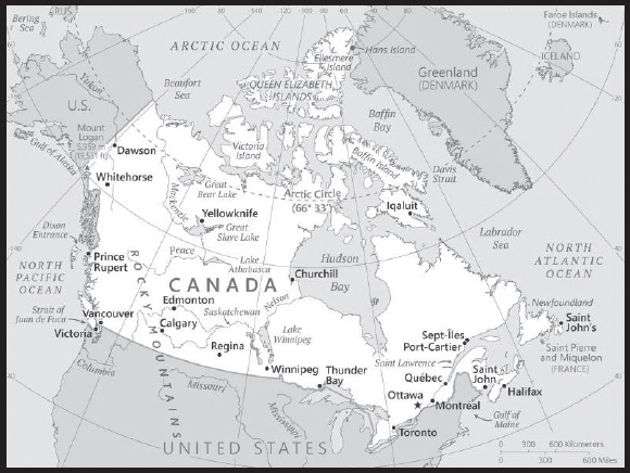
INTRODUCTION
Background: A land of vast distances and rich natural resources, Canada became a self-governing dominion in 1867, while retaining ties to the British crown. Canada gained legislative independence from Britain in 1931 and formalized its constitutional independence from the UK when it passed the Canada Act in 1982. Economically and technologically, the nation has developed in parallel with the US, its neighbor to the south across the world’s longest international border. Canada faces the political challenges of meeting public demands for quality improvements in health care, education, social services, and economic competitiveness, as well as responding to the particular concerns of predominantly francophone Quebec. Canada also aims to develop its diverse energy resources while maintaining its commitment to the environment.
GEOGRAPHY
Location: Northern North America, bordering the North Atlantic Ocean on the east, North Pacific Ocean on the west, and the Arctic Ocean on the north, north of the conterminous US
Geographic coordinates: 60 00 N, 95 00 W
Map references: North America
Area: total: 9,984,670 sq km
land: 9,093,507 sq km
water: 891,163 sq km
comparison ranking: total 3
Area - comparative: slightly larger than the US
Land boundaries: total: 8,892 km
border countries: US 8,891 km (includes 2,475 km with Alaska); Denmark (Greenland) 1.3 km
Coastline: 202,080 km
note: the Canadian Arctic Archipelago - consisting of 36,563 islands, several of them some of the world’s largest - contributes to Canada easily having the longest coastline in the world
Maritime claims: territorial sea: 12 nm
contiguous zone: 24 nm
exclusive economic zone: 200 nm
continental shelf: 200 nm or to the edge of the continental margin
Climate: varies from temperate in south to subarctic and arctic in north
Terrain: mostly plains with mountains in west, lowlands in southeast
Elevation: highest point: Mount Logan 5,959 m
lowest point: Atlantic/Pacific/Arctic Oceans 0 m
mean elevation: 487 m
Natural resources: bauxite, iron ore, nickel, zinc, copper, gold, lead, uranium, rare earth elements, molybdenum, potash, diamonds, silver, fish, timber, wildlife, coal, petroleum, natural gas, hydropower
Land use: agricultural land: 6.8% (2018 est.)
arable land: 4.7% (2018 est.)
permanent crops: 0.5% (2018 est.)
permanent pasture: 1.6% (2018 est.)
forest: 34.1% (2018 est.)
other: 59.1% (2018 est.)
Irrigated land: 9,045 sq km (2015)
Major lakes (area sq km): fresh water lake(s): Huron* - 35,972 sq km; Great Bear Lake - 31,328 sq km; Superior* - 28,754 sq km; Great Slave Lake - 28,568 sq km; Lake Winnipeg - 24,387 sq km; Erie* - 12,776 sq km; Ontario* - 9,790 sq km; Lake Athabasca - 7,935 sq km; Reindeer Lake - 6,650 sq km; Nettilling Lake - 5,542 sq km
note - Great Lakes* area shown as Canadian waters
Major rivers (by length in km): Mackenzie - 4, 241 km; Yukon river source (shared with the US [m]) - 3,185 km; Saint Lawrence river mouth (shared with US) - 3,058 km; Nelson - 2,570 km; Columbia river source (shared with the US [m]) - 1,953 km; Churchill - 1,600 km; Fraser - 1,368 km; Ottawa - 1,271 km; Athabasca - 1,231 km; North Saskatchewan - 1,220 km; Liard - 1,115 km
note – [s] after country name indicates river source; [m] after country name indicates river mouth
Major watersheds (area sq km): Atlantic Ocean drainage: Mississippi* (Gulf of Mexico) (3,202,185 sq km, Canada only 32,000 sq km), Nelson (Hudson Bay) (1,093,141 sq km), Saint Lawrence* (1,049,636 sq km, Canada only 839,200 sq km)
Arctic Ocean drainage: Mackenzie (1,706,388 sq km)
Pacific Ocean drainage: Yukon* (847,620 sq km, Canada only 823,800 sq km), Columbia* (657,501 sq km, Canada only 103,000 sq km)
note - watersheds shared with the US shown with *
Major aquifers: Northern Great Plains Aquifer
Population distribution: vast majority of Canadians are positioned in a discontinuous band within approximately 300 km of the southern border with the United States; the most populated province is Ontario, followed by Quebec and British Columbia
Natural hazards: continuous permafrost in north is a serious obstacle to development; cyclonic storms form east of the Rocky Mountains, a result of the mixing of air masses from the Arctic, Pacific, and North American interior, and produce most of the country’s rain and snow east of the mountains
volcanism: the vast majority of volcanoes in Western Canada’s Coast Mountains remain dormant
Geography - note: note 1: second-largest country in world (after Russia) and largest in the Americas; strategic location between Russia and US via north polar route; approximately 90% of the population is concentrated within 160 km (100 mi) of the US border
note 2: Canada has more fresh water than any other country and almost 9% of Canadian territory is water; Canada has at least 2 million and possibly over 3 million lakes - that is more than all other countries combined
PEOPLE AND SOCIETY
Population: 38,516,736 (2023 est.)
comparison ranking: 38
Nationality: noun: Canadian(s)
adjective: Canadian
Ethnic groups: Canadian 15.6%, English 14.7%, Scottish 12.1%, French 11%, Irish 12.1%, German 8.1%, Chinese 4.7%, Italian 4.3%, First Nations 1.7%, Indian 3.7%, Ukrainian 3.5%, Metis 1.5% (2021 est.)
note: percentages add up to more than 100% because respondents were able to identify more than one ethnic origin
Languages: English (official) 87.1%, French (official) 29.1%, Chinese languages 4.2%, Spanish 3.2%, Punjabi 2.6%, Arabic 2.4%, Tagalog 2.3%, Italian 1.5% (2022 est.)
major-language sample(s):
The World Factbook, une source indispensable d’informations de base. (French)
Religions: Christian 53.3%, Muslim 4.9%, Hindu 2.3%, Sikh 2.1%, Buddhist 1%, Jewish 0.9%, Traditional (North American Indigenous) 0.2%, other religions and traditional spirituality 0.6%, none 34.6% (2021 est.)
Age structure: 0-14 years: 15.65% (male 3,097,585/female 2,930,056)
15-64 years: 63.85% (male 12,367,172/female 12,224,077)
65 years and over: 20.5% (2023 est.) (male 3,630,580/female 4,267,266)
Dependency ratios: total dependency ratio: 52.1
youth dependency ratio: 23.9
elderly dependency ratio: 28.2
potential support ratio: 3.6 (2021 est.)
Median age: total: 41.8 years (2020)
male: 40.6 years
female: 42.9 years
comparison ranking: total 41
Population growth rate: 0.73% (2023 est.)
comparison ranking: 122
Birth rate: 10.11 births/1,000 population (2023 est.)
comparison ranking: 185
Death rate: 8.17 deaths/1,000 population (2023 est.)
comparison ranking: 83
Net migration rate: 5.37 migrant(s)/1,000 population (2023 est.)
comparison ranking: 19
Population distribution: vast majority of Canadians are positioned in a discontinuous band within approximately 300 km of the southern border with the United States; the most populated province is Ontario, followed by Quebec and British Columbia
Urbanization: urban population: 81.9% of total population (2023)
rate of urbanization: 0.95% annual rate of change (2020-25 est.)
Major urban areas - population: 6.372 million Toronto, 4.308 million Montreal, 2.657 million Vancouver, 1.640 million Calgary, 1.544 million Edmonton, 1.437 million OTTAWA (capital) (2023)
Sex ratio: at birth: 1.05 male(s)/female
0-14 years: 1.06 male(s)/female
15-64 years: 1.01 male(s)/female
65 years and over: 0.85 male(s)/female
total population: 0.98 male(s)/female (2023 est.)
Mother’s mean age at first birth: 29.4 years (2019 est.)
Maternal mortality ratio: 11 deaths/100,000 live births (2020 est.)
comparison ranking: 142
Infant mortality rate: total: 4.31 deaths/1,000 live births (2023 est.)
male: 4.6 deaths/1,000 live births
female: 4.02 deaths/1,000 live births
comparison ranking: total 184
Life expectancy at birth: total population: 83.99 years (2023 est.)
male: 81.72 years
female: 86.39 years
comparison ranking: total population 6
Total fertility rate: 1.57 children born/woman (2023 est.)
comparison ranking: 192
Gross reproduction rate: 0.77 (2023 est.)
Drinking water source: improved: urban: 99.3% of population
rural: 99.1% of population
total: 99.2% of population
unimproved: urban: 0.7% of population
rural: 0.9% of population
total: 0.8% of population (2020 est.)
Current health expenditure: 12.9% of GDP (2020)
Physicians density: 2.44 physicians/1,000 population (2019)
Hospital bed density: 2.5 beds/1,000 population (2019)
Sanitation facility access: improved: urban: 99.1% of population
rural: 98.9% of population
total: 99% of population
unimproved: urban: 0.9% of population
rural: 1.1% of population
total: 1% of population (2020 est.)
Obesity - adult prevalence rate: 29.4% (2016)
comparison ranking: 26
Alcohol consumption per capita: total: 8 liters of pure alcohol (2019 est.)
beer: 3.5 liters of pure alcohol (2019 est.)
wine: 2 liters of pure alcohol (2019 est.)
spirits: 2.1 liters of pure alcohol (2019 est.)
other alcohols: 0.4 liters of pure alcohol (2019 est.)
comparison ranking: total 44
Tobacco use: total: 13% (2020 est.)
male: 15.3% (2020 est.)
female: 10.7% (2020 est.)
comparison ranking: total 117
Currently married women (ages 15-49): 52.2% (2023 est.)
Education expenditures: 5.2% of GDP (2020 est.)
comparison ranking: 70
School life expectancy (primary to tertiary education): total: 17 years
male: 16 years
female: 17 years (2020)
Youth unemployment rate (ages 15-24): total: 14% (2021 est.)
male: 15%
female: 13.1%
comparison ranking: total 124
ENVIRONMENT
Environment - current issues: metal smelting, coal-burning utilities, and vehicle emissions impacting agricultural and forest productivity; air pollution and resulting acid rain severely affecting lakes and damaging forests; ocean waters becoming contaminated due to agricultural, industrial, mining, and forestry activities
Environment - international agreements: party to: Air Pollution, Air Pollution-Heavy Metals, Air Pollution-Multi-effect Protocol, Air Pollution-Nitrogen Oxides, Air Pollution-Persistent Organic Pollutants, Air Pollution-Sulphur 85, Air Pollution-Sulphur 94, Antarctic-Environmental Protection, Antarctic-Marine Living Resources, Antarctic Treaty, Biodiversity, Climate Change, Climate Change-Paris Agreement, Comprehensive Nuclear Test Ban, Desertification, Endangered Species, Environmental Modification, Hazardous Wastes, Law of the Sea, Marine Dumping-London Convention, Marine Dumping-London Protocol, Nuclear Test Ban, Ozone Layer Protection, Ship Pollution, Wetlands
signed, but not ratified: Air Pollution-Volatile Organic Compounds, Marine Life Conservation
Climate: varies from temperate in south to subarctic and arctic in north
Land use: agricultural land: 6.8% (2018 est.)
arable land: 4.7% (2018 est.)
permanent crops: 0.5% (2018 est.)
permanent pasture: 1.6% (2018 est.)
forest: 34.1% (2018 est.)
other: 59.1% (2018 est.)
Urbanization: urban population: 81.9% of total population (2023)
rate of urbanization: 0.95% annual rate of change (2020-25 est.)
Revenue from forest resources: 0.08% of GDP (2018 est.)
comparison ranking: 119
Revenue from coal: 0.08% of GDP (2018 est.)
comparison ranking: 27
Air pollutants: particulate matter emissions: 6.39 micrograms per cubic meter (2019 est.)
carbon dioxide emissions: 544.89 megatons (2016 est.)
methane emissions: 101.82 megatons (2020 est.)
Waste and recycling: municipal solid waste generated annually: 25,103,034 tons (2014 est.)
municipal solid waste recycled annually: 5,168,715 tons (2008 est.)
percent of municipal solid waste recycled: 20.6% (2008 est.)
Major lakes (area sq km): fresh water lake(s): Huron* - 35,972 sq km; Great Bear Lake - 31,328 sq km; Superior* - 28,754 sq km; Great Slave Lake - 28,568 sq km; Lake Winnipeg - 24,387 sq km; Erie* - 12,776 sq km; Ontario* - 9,790 sq km; Lake Athabasca - 7,935 sq km; Reindeer Lake - 6,650 sq km; Nettilling Lake - 5,542 sq km
note - Great Lakes* area shown as Canadian waters
Major rivers (by length in km): Mackenzie - 4, 241 km; Yukon river source (shared with the US [m]) - 3,185 km; Saint Lawrence river mouth (shared with US) - 3,058 km; Nelson - 2,570 km; Columbia river source (shared with the US [m]) - 1,953 km; Churchill - 1,600 km; Fraser - 1,368 km; Ottawa - 1,271 km; Athabasca - 1,231 km; North Saskatchewan - 1,220 km; Liard - 1,115 km
note – [s] after country name indicates river source; [m] after country name indicates river mouth
Major watersheds (area sq km): Atlantic Ocean drainage: Mississippi* (Gulf of Mexico) (3,202,185 sq km, Canada only 32,000 sq km), Nelson (Hudson Bay) (1,093,141 sq km), Saint Lawrence* (1,049,636 sq km, Canada only 839,200 sq km)
Arctic Ocean drainage: Mackenzie (1,706,388 sq km)
Pacific Ocean drainage: Yukon* (847,620 sq km, Canada only 823,800 sq km), Columbia* (657,501 sq km, Canada only 103,000 sq km)
note - watersheds shared with the US shown with *
Major aquifers: Northern Great Plains Aquifer
Total water withdrawal: municipal: 4.87 billion cubic meters (2020 est.)
industrial: 27.51 billion cubic meters (2020 est.)
agricultural: 3.86 billion cubic meters (2020 est.)
Total renewable water resources: 2.9 trillion cubic meters (2020 est.)
GOVERNMENT
Country name: conventional long form: none
conventional short form: Canada
etymology: the country name likely derives from the St. Lawrence Iroquoian word “kanata” meaning village or settlement
Government type: federal parliamentary democracy (Parliament of Canada) under a constitutional monarchy; a Commonwealth realm; federal and state authorities and responsibilities regulated in constitution
Capital: name: Ottawa
geographic coordinates: 45 25 N, 75 42 W
time difference: UTC-5 (same time as Washington, DC, during Standard Time)
daylight saving time: +1hr, begins second Sunday in March; ends first Sunday in November
time zone note: Canada has six time zones
etymology: the city lies on the south bank of the Ottawa River, from which it derives its name; the river name comes from the Algonquin word “adawe” meaning “to trade” and refers to the indigenous peoples who used the river as a trade highway
Administrative divisions: 10 provinces and 3 territories*; Alberta, British Columbia, Manitoba, New Brunswick, Newfoundland and Labrador, Northwest Territories*, Nova Scotia, Nunavut*, Ontario, Prince Edward Island, Quebec, Saskatchewan, Yukon*
Independence: 1 July 1867 (union of British North American colonies); 11 December 1931 (recognized by UK per Statute of Westminster)
National holiday: Canada Day, 1 July (1867)
Constitution: history: consists of unwritten and written acts, customs, judicial decisions, and traditions dating from 1763; the written part of the constitution consists of the Constitution Act of 29 March 1867, which created a federation of four provinces, and the Constitution Act of 17 April 1982
amendments: proposed by either house of Parliament or by the provincial legislative assemblies; there are 5 methods for passage though most require approval by both houses of Parliament, approval of at least two thirds of the provincial legislative assemblies and assent and formalization as a proclamation by the governor general in council; the most restrictive method is reserved for amendments affecting fundamental sections of the constitution, such as the office of the monarch or the governor general, and the constitutional amendment procedures, which require unanimous approval by both houses and by all the provincial assemblies, and assent of the governor general in council; amended 11 times, last in 2011 (Fair Representation Act, 2011)
Legal system: common law system except in Quebec, where civil law based on the French civil code prevails
International law organization participation: accepts compulsory ICJ jurisdiction with reservations; accepts ICCt jurisdiction
Citizenship: citizenship by birth: yes
citizenship by descent only: yes
dual citizenship recognized: yes
residency requirement for naturalization: minimum of 3 of last 5 years resident in Canada
Suffrage: 18 years of age; universal
Executive branch: chief of state: King CHARLES III (since 8 September 2022); represented by Governor General Mary SIMON (since 6 July 2021)
head of government: Prime Minister Justin Pierre James TRUDEAU (Liberal Party) (since 4 November 2015)
cabinet: Federal Ministry chosen by the prime minister usually from among members of his/her own party sitting in Parliament
elections/appointments: the monarchy is hereditary; governor general appointed by the monarch on the advice of the prime minister for a 5-year term; following legislative elections, the leader of the majority party or majority coalition in the House of Commons generally designated prime minister by the governor general
note: the governor general position is largely ceremonial
Legislative branch: description: bicameral Parliament or Parlement consists of:
Senate or Senat (105 seats; members appointed by the governor general on the advice of the prime minister and can serve until age 75)
House of Commons or Chambre des Communes (338 seats; members directly elected in single-seat constituencies by simple majority vote with terms up to 4 years)
elections: Senate - appointed; latest appointments in July 2021
House of Commons - last held on 20 September 2021 (next to be held on or before 20 October 2025)
election results:
Senate - composition as of October 2023 - men 43, women 51, percent of women 54.3%
House of Commons - percent of vote by party - CPC 33.7%, Liberal Party 32.6%, NDP 17.8%, Bloc Quebecois 7.7%, Greens 2.3%, other 5.9%; seats by party - Liberal Party 159, CPC 119, NDP 25, Bloc Quebecois 32, Greens 2, independent 1; composition as of October 2023 - men 233, women 103; percent of women 30.6%; note - total Parliament percent of women 34.6%
Judicial branch: highest court(s): Supreme Court of Canada (consists of the chief justice and 8 judges); note - in 1949, Canada abolished all appeals beyond its Supreme Court, which prior to that time, were heard by the Judicial Committee of the Privy Council (in London)
judge selection and term of office: chief justice and judges appointed by the prime minister in council; all judges appointed for life with mandatory retirement at age 75
subordinate courts: federal level: Federal Court of Appeal; Federal Court; Tax Court; federal administrative tribunals; Courts Martial; provincial/territorial level: provincial superior, appeals, first instance, and specialized courts; note - in 1999, the Nunavut Court - a circuit court with the power of a provincial superior court, as well as a territorial court - was established to serve isolated settlements
Political parties and leaders: Bloc Quebecois [Yves-Francois BLANCHET]
Conservative Party of Canada or CPC [Pierre POILIEVRE]
Green Party [Elizabeth MAY]
Liberal Party [Justin TRUDEAU]
New Democratic Party or NDP [Jagmeet SINGH]
People’s Party of Canada [Maxime BERNIER]
International organization participation: ADB (nonregional member), AfDB (nonregional member), APEC, Arctic Council, ARF, ASEAN (dialogue partner), Australia Group, BIS, C, CD, CDB, CE (observer), EAPC, EBRD, EITI (implementing country), FAO, FATF, G-7, G-8, G-10, G-20, IADB, IAEA, IBRD, ICAO, ICC (national committees), ICCt, ICRM, IDA, IEA, IFAD, IFC, IFRCS, IGAD (partners), IHO, ILO, IMF, IMO, IMSO, Interpol, IOC, IOM, IPU, ISO, ITSO, ITU, ITUC (NGOs), MIGA, MINUSTAH, MONUSCO, NAFTA, NATO, NEA, NSG, OAS, OECD, OIF, OPCW, OSCE, Pacific Alliance (observer), Paris Club, PCA, PIF (partner), UN, UNCTAD, UNESCO, UNFICYP, UNHCR, UNMISS, UNRWA, UNTSO, UPU, USMCA, Wassenaar Arrangement, WCO, WFTU (NGOs), WHO, WIPO, WMO, WTO, ZC
Diplomatic representation in the US: chief of mission: Ambassador Kirsten HILLMAN (since 17 July 2020)
chancery: 501 Pennsylvania Avenue NW, Washington, DC 20001
telephone: [1] (844) 880-6519
FAX: [1] (202) 682-7738
email address and website:
https://www.international.gc.ca/country-pays/us-eu/washington.aspx?lang=eng
consulate(s) general: Atlanta, Boston, Chicago, Dallas, Denver, Detroit, Los Angeles, Miami, Minneapolis, New York, San Francisco/Silicon Valley, Seattle
trade office(s): Houston, Palo Alto (CA), San Diego; note - there are trade offices in the Consulates General
Diplomatic representation from the US: chief of mission: Ambassador David L. COHEN (since December 2021)
embassy: 490 Sussex Drive, Ottawa, Ontario K1N 1G8
mailing address: 5480 Ottawa Place, Washington DC 20521-5480
telephone: [1] (613) 238-5335
FAX: [1] (613) 241-7845
email address and website:
consulate(s) general: Calgary, Halifax, Montreal, Quebec City, Toronto, Vancouver
consulate(s): Winnipeg
Flag description: two vertical bands of red (hoist and fly side, half width) with white square between them; an 11-pointed red maple leaf is centered in the white square; the maple leaf has long been a Canadian symbol
National symbol(s): maple leaf, beaver; national colors: red, white
National anthem: name: “O Canada”
lyrics/music: Adolphe-Basile ROUTHIER [French], Robert Stanley WEIR [English]/Calixa LAVALLEE
note: adopted 1980; originally written in 1880, “O Canada” served as an unofficial anthem many years before its official adoption; the anthem has French and English versions whose lyrics differ; as a Commonwealth realm, in addition to the national anthem, “God Save the King” serves as the royal anthem (see United Kingdom)
National heritage: total World Heritage Sites: 21 (10 cultural, 10 natural, 1 mixed) (2021)
selected World Heritage Site locales: L’Anse aux Meadows (c); Canadian Rocky Mountain Parks (n); Dinosaur Provincial Park (n); Historic District of Old Quebec (c); Old Town Lunenburg (c); Wood Buffalo National Park (n); Head-Smashed-In Buffalo Jump (c); Gros Morne National Park (n); Pimachiowin Aki (m)
ECONOMY
Economic overview: one of the world’s largest economies; leading global financier and macroeconomic partner; largest US trading partner; key timber and oil and gas industries; Canada sends over half its development aid to the World Bank; key “blue economy” developer
Real GDP (purchasing power parity): $1.832 trillion (2021 est.)
$1.752 trillion (2020 est.)
$1.849 trillion (2019 est.)
note: data are in 2017 dollars
comparison ranking: 15
Real GDP growth rate: 4.54% (2021 est.)
-5.23% (2020 est.)
1.88% (2019 est.)
comparison ranking: 103
Real GDP per capita: $47,900 (2021 est.)
$46,100 (2020 est.)
$49,200 (2019 est.)
note: data are in 2017 dollars
comparison ranking: 33
GDP (official exchange rate)
$1,741,865,000,000 (2019 est.)
Inflation rate (consumer prices): 3.4% (2021 est.)
0.72% (2020 est.)
1.95% (2019 est.)
comparison ranking: 111
Credit ratings: Fitch rating: AA+ (2020)
Moody’s rating: Aaa (2002)
Standard & Poors rating: AAA (2002)
note: The year refers to the year in which the current credit rating was first obtained.
GDP - composition, by sector of origin
agriculture: 1.6% (2017 est.)
industry: 28.2% (2017 est.)
services: 70.2% (2017 est.)
comparison rankings: services 68; industry 93; agriculture 187
GDP - composition, by end use
household consumption: 57.8% (2017 est.)
government consumption: 20.8% (2017 est.)
investment in fixed capital: 23% (2017 est.)
investment in inventories: 0.7% (2017 est.)
exports of goods and services: 30.9% (2017 est.)
imports of goods and services: -33.2% (2017 est.)
Agricultural products: wheat, rapeseed, maize, barley, milk, soybeans, potatoes, oats, peas, pork
Industries: transportation equipment, chemicals, processed and unprocessed minerals, food products, wood and paper products, fish products, petroleum, natural gas
Industrial production growth rate: 4.74% (2021 est.)
comparison ranking: 95
Labor force: 21.017 million (2021 est.)
comparison ranking: 32
Labor force - by occupation: agriculture: 2%
industry: 13%
services: 6%
industry and services: 76%
manufacturing: 3% (2006 est.)
Unemployment rate: 7.51% (2021 est.)
9.46% (2020 est.)
5.66% (2019 est.)
comparison ranking: 104
Youth unemployment rate (ages 15-24): total: 14% (2021 est.)
male: 15%
female: 13.1%
comparison ranking: total 124
Population below poverty line: 9.4% (2008 est.)
note: this figure is the Low Income Cut-Off, a calculation that results in higher figures than found in many comparable economies; Canada does not have an official poverty line
Gini Index coefficient - distribution of family income: 33.3 (2017 est.)
comparison ranking: 121
Average household expenditures: on food: 9.1% of household expenditures (2018 est.)
on alcohol and tobacco: 3.3% of household expenditures (2018 est.)
Household income or consumption by percentage share: lowest 10%: 2.6%
highest 10%: 24.8% (2000)
Budget: revenues: $686.718 billion (2020 est.)
expenditures: $861.955 billion (2020 est.)
Budget surplus (+) or deficit (-): -1% (of GDP) (2017 est.)
comparison ranking: 76
Public debt: 72.09% of GDP (2020 est.)
48.01% of GDP (2019 est.)
48.18% of GDP (2018 est.)
note: figures are for gross general government debt, as opposed to net federal debt; gross general government debt includes both intragovernmental debt and the debt of public entities at the sub-national level
comparison ranking: 55
Taxes and other revenues: 13.3% (of GDP) (2020 est.)
comparison ranking: 165
Fiscal year: 1 April - 31 March
Current account balance: $826.662 million (2021 est.)
-$29.216 billion (2020 est.)
-$35.434 billion (2019 est.)
comparison ranking: 53
Exports: $611.146 billion (2021 est.)
$484.226 billion (2020 est.)
$561.63 billion (2019 est.)
note: Data are in current year dollars and do not include illicit exports or re-exports.
comparison ranking: 14
Exports - partners: US 73% (2019)
Exports - commodities: crude petroleum, cars and vehicle parts, natural gas, gold, lumber (2021)
Imports: $609.256 billion (2021 est.) note: data are in current year dollars
$517.964 billion (2020 est.) note: data are in current year dollars
$589.037 billion (2019 est.) note: data are in current year dollars
comparison ranking: 13
Imports - partners: US 57%, China 11%, Mexico 5% (2019)
Imports - commodities: cars and vehicle parts, delivery trucks, crude petroleum, refined petroleum (2019)
Reserves of foreign exchange and gold: $106.615 billion (31 December 2021 est.)
$90.428 billion (31 December 2020 est.)
$85.297 billion (31 December 2019 est.)
comparison ranking: 29
Debt - external: $2,124,887,000,000 (2019 est.)
$1,949,796,000,000 (2018 est.)
comparison ranking: 12
Exchange rates: Canadian dollars (CAD) per US dollar -
Exchange rates:: 1.254 (2021 est.)
1.341 (2020 est.)
1.327 (2019 est.)
1.296 (2018 est.)
1.298 (2017 est.)
ENERGY
Electricity access: electrification - total population: 100% (2021)
Electricity: installed generating capacity: 153.251 million kW (2020 est.)
consumption: 539.695 billion kWh (2020 est.)
exports: 67.2 billion kWh (2020 est.)
imports: 9.8 billion kWh (2020 est.)
transmission/distribution losses: 32.937 billion kWh (2020 est.)
comparison rankings: transmission/distribution losses 12; imports 26; exports 1; consumption 7; installed generating capacity 8
Electricity generation sources: fossil fuels: 16.5% of total installed capacity (2020 est.)
nuclear: 14.7% of total installed capacity (2020 est.)
solar: 0.7% of total installed capacity (2020 est.)
wind: 5.7% of total installed capacity (2020 est.)
hydroelectricity: 60.8% of total installed capacity (2020 est.)
biomass and waste: 1.6% of total installed capacity (2020 est.)
Nuclear energy: Number of operational nuclear reactors: 19 (2023)
Number of nuclear reactors under construction: 0
Net capacity of operational nuclear reactors: 13.62GW (2023)
Percent of total electricity production: 15% (2021)
Percent of total energy produced: 4% (2021)
Number of nuclear reactors permanently shut down: 2
Coal: production: 48.328 million metric tons (2020 est.)
consumption: 25.642 million metric tons (2020 est.)
exports: 32.026 million metric tons (2020 est.)
imports: 7.577 million metric tons (2020 est.)
proven reserves: 6.582 billion metric tons (2019 est.)
Petroleum: total petroleum production: 5,468,100 bbl/day (2021 est.)
refined petroleum consumption: 2,629,300 bbl/day (2019 est.)
crude oil and lease condensate exports: 3.177 million bbl/day (2018 est.)
crude oil and lease condensate imports: 793,800 bbl/day (2018 est.)
crude oil estimated reserves: 170.3 billion barrels (2021 est.)
Refined petroleum products - production: 2.009 million bbl/day (2017 est.)
comparison ranking: 10
Refined petroleum products - exports: 1.115 million bbl/day (2017 est.)
comparison ranking: 8
Refined petroleum products - imports: 405,700 bbl/day (2017 est.)
comparison ranking: 21
Natural gas: production: 178,723,494,000 cubic meters (2019 est.)
consumption: 124,502,315,000 cubic meters (2019 est.)
exports: 76,094,066,000 cubic meters (2019 est.)
imports: 28,026,440,000 cubic meters (2019 est.)
proven reserves: 2,067,126,000,000 cubic meters (2021 est.)
Carbon dioxide emissions: 612.084 million metric tonnes of CO2 (2019 est.)
from coal and metallurgical coke: 56.087 million metric tonnes of CO2 (2019 est.)
from petroleum and other liquids: 311.336 million metric tonnes of CO2 (2019 est.)
from consumed natural gas: 244.66 million metric tonnes of CO2 (2019 est.)
comparison ranking: total emissions 9
Energy consumption per capita: 403.7 million Btu/person (2019 est.)
comparison ranking: 6
COMMUNICATIONS
Telephones - fixed lines: total subscriptions: 12.928 million (2021 est.)
subscriptions per 100 inhabitants: 34 (2021 est.)
comparison ranking: total subscriptions 16
Telephones - mobile cellular: total subscriptions: 32.723 million (2021 est.)
subscriptions per 100 inhabitants: 86 (2021 est.)
comparison ranking: total subscriptions 44
Telecommunication systems: general assessment: the Canadian telecom market continues to show steady development as operators invest in network upgrades; much of the investment among telcos has been channeled into LTE infrastructure to capitalize on consumer demand for mobile data services, while there has also been further investment in 5G; investment programs have also been supported by regulatory efforts to ensure that operators have spectrum available to develop 5G services; an investment in fixed-line infrastructure, focused on FttP and, among cable broadband providers; government policy has encouraged the extension of broadband to rural and regional areas, with the result that services are almost universally available and the emphasis now is on improving service speeds to enable the entire population to benefit from the digital economy and society; cable broadband is the principal access platform, followed by DSL; the mobile rate remains comparatively low by international standards; Canadians have provided for LTE and LTE-A infrastructure; despite topographical challenges and the remoteness of many areas, the major players effectively offer 99% population coverage with LTE; operators now provide up to 70% population coverage with 5G (2022)
domestic: Nearly 34 per 100 fixed-line and 86 per 100 mobile-cellular teledensity (2021)
international: country code - 1; landing points for the Nunavut Undersea Fiber Optic Network System, Greenland Connect, Persona, GTT Atlantic, and Express, KetchCan 1 Submarine Fiber Cable system, St Pierre and Miquelon Cable submarine cables providing links to the US and Europe; satellite earth stations - 7 (5 Intelsat - 4 Atlantic Ocean and 1 Pacific Ocean, and 2 Intersputnik - Atlantic Ocean region) (2019)
Broadcast media: 2 public TV broadcasting networks, 1 in English and 1 in French, each with a large number of network affiliates; several private-commercial networks also with multiple network affiliates; overall, about 150 TV stations; multi-channel satellite and cable systems provide access to a wide range of stations including US stations; mix of public and commercial radio broadcasters with the Canadian Broadcasting Corporation (CBC), the public radio broadcaster, operating 4 radio networks, Radio Canada International, and radio services to indigenous populations in the north; roughly 1,119 licensed radio stations (2016)
Internet country code: .ca
Internet users: total: 35.34 million (2021 est.)
percent of population: 93% (2021 est.)
comparison ranking: total 28
Broadband - fixed subscriptions: total: 15,825,813 (2020 est.)
subscriptions per 100 inhabitants: 42 (2020 est.)
comparison ranking: total 16
TRANSPORTATION
National air transport system: number of registered air carriers: 51 (2020)
inventory of registered aircraft operated by air carriers: 879
annual passenger traffic on registered air carriers: 89.38 million (2018)
annual freight traffic on registered air carriers: 3,434,070,000 (2018) mt-km
Civil aircraft registration country code prefix: C
Airports: 1,467 (2021)
comparison ranking: total 4
Airports - with paved runways: 523
civil airports: 123
military airports: 8
joint use (civil-military) airports: 3
other airports: 389
note: paved runways have a concrete or asphalt surface but not all have facilities for refueling, maintenance, or air traffic control; the length of a runway required for aircraft to safely operate depends on a number of factors including the type of aircraft, the takeoff weight (including passengers, cargo, and fuel), engine types, flap settings, landing speed, elevation of the airport, and average maximum daily air temperature; paved runways can reach a length of 5,000 m (16,000 ft.), but the “typical” length of a commercial airline runway is between 2,500-4,000 m (8,000-13,000 ft.)
Airports - with unpaved runways: 944
note: unpaved runways have a surface composition such as grass or packed earth and are most suited to the operation of light aircraft; unpaved runways are usually short, often less than 1,000 m (3,280 ft.) in length; airports with unpaved runways often lack facilities for refueling, maintenance, or air traffic control
Heliports: 26 (2021)
Pipelines: 840,000 km oil and gas (2020)
Railways: total: 49,422 km (2021) note: 129 km electrified (2021)
standard gauge: 49,422 km (2021) 1.435-m gauge
comparison ranking: total 5
Roadways: total: 1,042,300 km (2011)
paved: 415,600 km (2011) (includes 17,000 km of expressways)
unpaved: 626,700 km (2011)
comparison ranking: total 8
Waterways: 636 km (2011) (Saint Lawrence Seaway of 3,769 km, including the Saint Lawrence River of 3,058 km, shared with United States)
comparison ranking: 85
Merchant marine: total: 689 (2022)
by type: bulk carrier 21, container ship 1, general cargo 65, oil tanker 15, other 587
comparison ranking: total 33
Ports and terminals: major seaport(s): Halifax, Saint John (New Brunswick), Vancouver
oil terminal(s): Lower Lakes terminal
container port(s) (TEUs): Montreal (1,585,465), Vancouver (3,678,952) (2021)
LNG terminal(s) (import): Saint John
river and lake port(s): Montreal, Quebec City, Sept-Isles (St. Lawrence)
dry bulk cargo port(s): Port-Cartier (iron ore and grain),
Fraser River Port (Fraser) Hamilton (Lake Ontario)
Transportation - note: Canada operates a fleet of 12 icebreakers including two PC 3 or 4 class medium icebreakers and ten PC 5 or 6 class light icebreakers
note - PC indicates a Polar Class vessel: PC 3 - year-round operation in second-year ice which may include multi-year ice inclusions (ice thickness up to 2.5 m); PC 4 - year-round operation in thick first-year ice which may include old ice inclusions (ice thickness up to 120 cm); PC 5 - year-round operation in medium first-year ice which may include old ice inclusions (ice thickness up to 70-120 cm); PC 6 - summer/autumn operation in medium first-year ice which may include old ice inclusions (ice thickness up to 30-70 cm)
Canadian Coast Guard Ship Louis S. St-Laurent:
MILITARY AND SECURITY
Military and security forces: Canadian Forces: Canadian Army, Royal Canadian Navy, Royal Canadian Air Force; Department of Fisheries and Oceans: Coast Guard (2023)
note 1: the CAF is comprised of both a Regular Force and a Reserve Force; the Reserve Force is part of all three services (Army, Navy, and Air Force) and is considered an integral component of the CAF; reservists are primarily part-time service positions; they may volunteer for full-time employment or deployment on operations; they typically serve one or more evenings a week and/or during weekends at locations close to home; the Reserve Force is comprised of the Primary Reserve, Canadian Rangers, Cadet Organizations Administration and Training Service, and the Supplementary Reserve; the Canadian Rangers are part of the Army Reserve Force and provide a limited presence in Canada’s northern, coastal, and isolated areas for sovereignty, public safety, and surveillance roles
note 2: the Royal Canadian Mounted Police (RCMP or “Mounties”) are under the Department of Public Safety; only Ontario, Quebec, and Newfoundland and Labrador have provincial police forces, but the Royal Newfoundland Constabulary contracts policing in regions of the province to the RCMP; the RCMP and municipal forces provide coverage for other provinces and territories; some Indigenous reserves provide Indigenous policing; provincial and municipal police report to their respective provincial authorities
Military expenditures: 1.4% of GDP (2023)
1.2% of GDP (2022 est.)
1.3% of GDP (2021)
1.4% of GDP (2020)
1.3% of GDP (2019)
comparison ranking: 99
Military and security service personnel strengths: approximately 70,000 active armed forces personnel (23,000 Army; 12,000 Navy; 12,000 Air Force; 23,000 other) (2023)
note: the Army also has approximately 19,000 part-time volunteer soldiers in the Reserve Force, including about 5,500 Rangers
Military equipment inventories and acquisitions: the CAF’s inventory is a mix of domestically produced equipment and imported weapons systems from Australia, Europe, Israel, and the US; in recent years, the leading supplier has been the US; Canada’s defense industry develops, maintains, and produces a range of equipment, including aircraft, combat vehicles, naval vessels, and associated components (2023)
Military service age and obligation: 17 years of age for voluntary male and female military service (with parental consent); 16 years of age for Reserve and Military College applicants; Canadian citizenship or permanent residence status required; maximum 34 years of age; service obligation 3-9 years (2023)
note 1: Canada opened up all military occupations to women in 2001; women in 2023 comprised about 16% of the CAF
note 2: the CAF offers waivers to foreign nationals applying for military service only in exceptional cases — to individuals on international military exchanges, for example, or to candidates who have specialized skills in high demand
Military deployments: the CAF has approximately 1,000 military personnel forward deployed for NATO air, land, and sea missions in the European theater, including a ground task force in Latvia (2023)
note: in response to Russia’s 2022 invasion of Ukraine, some NATO countries, including Canada, have sent additional troops and equipment to the battlegroups deployed in NATO territory in eastern Europe
Military - note: the Canadian Armed Forces (CAF) are a professional volunteer force responsible for external security; the CAF’s core missions include detecting, deterring, and defending against threats to or attacks on Canada; the military also provides assistance to civil authorities and law enforcement as needed for such missions as counterterrorism, search and rescue, and responding to natural disasters or other major emergencies; it regularly participates in bilateral and multinational training exercises with a variety of partners, including NATO (Canada is one of the original members) and the US; the CAF also contributes to international peacekeeping, stability, humanitarian, combat, and capacity building operations with the UN, NATO, and other security partners
the Canadian Joint Operations Command (CJOC) plans, directs, and leads most CAF operations in Canada, North America, and around the world; it has 6 standing regional Joint Task Force (JTF) headquarters across Canada, as well as other JTFs deployed overseas; the CJOC is assisted by air, ground, and naval components; the Canadian Army is the land component of the CAF and its largest element; it has 4 divisional headquarters (plus 1 under the CJOC), 3 Regular Force combined arms mechanized brigade groups, and 10 brigade groups in the Reserve Force; the Navy’s principal warships are 12 frigates and 4 attack submarines, which are supported by 6 Arctic/offshore patrol ships and 12 coastal defense vessels; the Air Force has over 400 fixed wing aircraft and helicopters, including about 100 US-made F/A-18 multirole fighters; Canada has ordered more than 80 US-made F-35 stealth multirole fighter aircraft which the Air Force expects to start receiving in 2026; the CAF also has a separate Special Operations Forces Command with a special operations regiment and a joint task force, plus air, incident response, and training units
Canada is part of the North American Aerospace Defense Command (NORAD; established 1958); NORAD is a Canada-US bi-national military command responsible for monitoring and defending North American airspace; traditionally, a Canadian Armed Forces officer has served as the deputy commander of NORAD; Canada’s defense relationship with the US extends back to the Ogdensburg Declaration of 1940, when the two countries formally agreed on military cooperation, including the establishment of the Permanent Joint Board on Defense (PJBD), which continues to be the highest-level bilateral defense forum between Canada and the US
British troops withdrew from Canada in 1871 as part of the UK-US Treaty of Washington; following the withdrawal, the first Canadian militia, known as the Royal Canadian Regiment, was organized in 1883 to protect Canadian territory and defend British interests abroad, which it did in the South African War (1899-1902), Canada’s first overseas conflict; militia units formed the backbone of the more than 425,000 Canadian soldiers that went to Europe during World War I in what was called the Canadian Expeditionary Force; the Royal Canadian Navy was created in 1910, while the Canadian Air Force was established in 1920 and became the Royal Canadian Air Force in 1924; the Canadian Army was officially founded in 1942; a unified Canadian Armed Forces was created in 1968 (2023)
SPACE
Space agency/agencies: Canadian Space Agency (CSA; established 1989) (2023)
Space launch site(s): Churchill Rocket Research Range (sounding rockets; Manitoba); constructing a private, commercial space launch site in Nova Scotia (2023)
Space program overview: has a substantial program, a national space strategy, and a long history of developing space-related technologies; designs, builds, operates, and tracks communications, remote sensing (RS), multi-mission, and scientific/testing satellites; has an astronaut program (train in the US); designs, builds, or contributes to a variety of other space-related programs, including space telescopes, planetary probes, sensors, and robotic systems (such as the Canadian-made robotic arms used on the US Space Shuttle and the International Space Station); participates in international space efforts and cooperates with a variety of foreign space agencies and commercial entities, including those of Argentina, Brazil, the European Space Agency (ESA)/EU (and their member states), India, and particularly the US; ESA Cooperating State since 1979; has a robust commercial space sector that is involved in satellite communications, optics, space exploration, navigation, and space science (2023)
note: further details about the key activities, programs, and milestones of the country’s space program, as well as government spending estimates on the space sector, appear in Appendix S
TERRORISM
Terrorist group(s): Terrorist group(s): Islamic State of Iraq and ash-Sham (ISIS); Hizballah
note: details about the history, aims, leadership, organization, areas of operation, tactics, targets, weapons, size, and sources of support of the group(s) appear(s) in Appendix-T
TRANSNATIONAL ISSUES
Disputes - international: managed maritime boundary disputes with the US at Dixon Entrance, Beaufort Sea, Strait of Juan de Fuca, and the Gulf of Maine, including the disputed Machias Seal Island and North Rock; Canada and the United States dispute how to divide the Beaufort Sea and the status of the Northwest Passage but continue to work cooperatively to survey the Arctic continental shelf; US works closely with Canada to intensify security measures for monitoring and controlling legal and illegal movement of people, transport, and commodities across the international border; commencing the collection of technical evidence for submission to the Commission on the Limits of the Continental Shelf in support of claims for continental shelf beyond 200 nm from its declared baselines in the Arctic, as stipulated in Article 76, paragraph 8, of the UN Convention on the Law of the Sea
Refugees and internally displaced persons: refugees (country of origin): 22,400 (Venezuela) (refugees and migrants) (2020); 5,254 (Iran) (mid-year 2021)
stateless persons: 4,323 (2022)
Illicit drugs: transnational criminal organizations trafficked cocaine, opium, methamphetamine, other synthetic drugs, and prescription drugs (some of which transited the United States) to Canada for domestic consumption; a source of synthetic drugs (including synthetic opioids), cannabis, and MDMA trafficked to the United States; a major source of precursor or essential chemicals used in the production of illicit narcotics
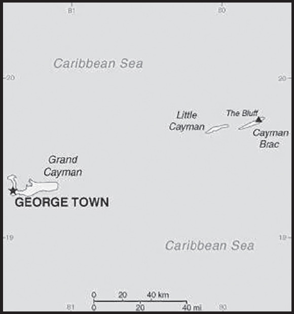
INTRODUCTION
Background: The Cayman Islands were colonized from Jamaica by the British during the 18th and 19th centuries and were administered by Jamaica after 1863. In 1959, the islands became a territory within the Federation of the West Indies. When the Federation dissolved in 1962, the Cayman Islands chose to remain a British dependency. The territory has transformed itself into a significant offshore financial center.
GEOGRAPHY
Location: Caribbean, three-island group (Grand Cayman, Cayman Brac, Little Cayman) in Caribbean Sea, 240 km south of Cuba and 268 km northwest of Jamaica
Geographic coordinates: 19 30 N, 80 30 W
Map references: Central America and the Caribbean
Area: total: 264 sq km
land: 264 sq km
water: 0 sq km
comparison ranking: total 210
Area - comparative: 1.5 times the size of Washington, DC
Land boundaries: total: 0 km
Coastline: 160 km
Maritime claims: territorial sea: 12 nm
exclusive economic zone: 200 nm
exclusive fishing zone: 200 nm
Climate: tropical marine; warm, rainy summers (May to October) and cool, relatively dry winters (November to April)
Terrain: low-lying limestone base surrounded by coral reefs
Elevation: highest point: 1 km SW of The Bluff on Cayman Brac 50 m
lowest point: Caribbean Sea 0 m
Natural resources: fish, climate and beaches that foster tourism
Land use: agricultural land: 11.2% (2018 est.)
arable land: 0.8% (2018 est.)
permanent crops: 2.1% (2018 est.)
permanent pasture: 8.3% (2018 est.)
forest: 52.9% (2018 est.)
other: 35.9% (2018 est.)
Population distribution: majority of the population resides on Grand Cayman
Natural hazards: hurricanes (July to November)
Geography - note: important location between Cuba and Central America
PEOPLE AND SOCIETY
Population: 65,483 (2023 est.)
note: most of the population lives on Grand Cayman
comparison ranking: 204
Nationality: noun: Caymanian(s)
adjective: Caymanian
Ethnic groups: mixed 40%, White 20%, African descent 20%, expatriates of various ethnic groups 20%
Languages: English (official) 90.9%, Spanish 4%, Filipino 3.3%, other 1.7%, unspecified 0.1% (2010 est.)
Religions: Protestant 67.8% (includes Church of God 22.6%, Seventh Day Adventist 9.4%, Presbyterian/United Church 8.6%, Baptist 8.3%, Pentecostal 7.1%, non-denominational 5.3%, Anglican 4.1%, Wesleyan Holiness 2.4%), Roman Catholic 14.1%, Jehovah’s Witness 1.1%, other 7%, none 9.3%, unspecified 0.7% (2010 est.)
Age structure: 0-14 years: 17.48% (male 5,761/female 5,684)
15-64 years: 66.48% (male 21,271/female 22,261)
65 years and over: 16.04% (2023 est.) (male 4,792/female 5,714)
Dependency ratios: total dependency ratio: 32.6
youth dependency ratio: 22.3
elderly dependency ratio: 10.4
potential support ratio: 9.6 (2021)
Median age: total: 40.5 years (2020)
male: 39.7 years
female: 41.2 years
comparison ranking: total 51
Population growth rate: 1.79% (2023 est.)
comparison ranking: 50
Birth rate: 11.62 births/1,000 population (2023 est.)
comparison ranking: 159
Death rate: 6.06 deaths/1,000 population (2023 est.)
comparison ranking: 154
Net migration rate: 12.34 migrant(s)/1,000 population (2023 est.)
note: major destination for Cubans trying to migrate to the US
comparison ranking: 6
Population distribution: majority of the population resides on Grand Cayman
Urbanization: urban population: 100% of total population (2023)
rate of urbanization: 1.13% annual rate of change (2020-25 est.)
Major urban areas - population: 35,000 GEORGE TOWN (capital) (2018)
Sex ratio: at birth: 1.02 male(s)/female
0-14 years: 1.01 male(s)/female
15-64 years: 0.96 male(s)/female
65 years and over: 0.84 male(s)/female
total population: 0.95 male(s)/female (2023 est.)
Infant mortality rate: total: 7.47 deaths/1,000 live births (2023 est.)
male: 9.04 deaths/1,000 live births
female: 5.87 deaths/1,000 live births
comparison ranking: total 155
Life expectancy at birth: total population: 82.25 years (2023 est.)
male: 79.57 years
female: 84.98 years
comparison ranking: total population 28
Total fertility rate: 1.82 children born/woman (2023 est.)
comparison ranking: 139
Gross reproduction rate: 0.9 (2023 est.)
Drinking water source: improved: urban: 97.4% of population
total: 97.4% of population
unimproved: urban: 2.6% of population
total: 2.6% of population (2015 est.)
Sanitation facility access: improved: urban: 95.6% of population
total: 95.6% of population
unimproved: urban: 4.4% of population
total: 4.4% of population (2015 est.)
Currently married women (ages 15-49): 51.4% (2023 est.)
Education expenditures: 2.1% of GDP (2019)
comparison ranking: 185
Literacy: total population: 98.9%
male: 98.7%
female: 99% (2021)
Youth unemployment rate (ages 15-24): total: 13.8% (2015 est.)
male: 16.4%
female: 11.4%
comparison ranking: total 126
ENVIRONMENT
Environment - current issues: no natural freshwater resources; drinking water supplies are met by reverse osmosis desalination plants and rainwater catchment; trash washing up on the beaches or being deposited there by residents; no recycling or waste treatment facilities; deforestation (trees being cut down to create space for commercial use)
Climate: tropical marine; warm, rainy summers (May to October) and cool, relatively dry winters (November to April)
Land use: agricultural land: 11.2% (2018 est.)
arable land: 0.8% (2018 est.)
permanent crops: 2.1% (2018 est.)
permanent pasture: 8.3% (2018 est.)
forest: 52.9% (2018 est.)
other: 35.9% (2018 est.)
Urbanization: urban population: 100% of total population (2023)
rate of urbanization: 1.13% annual rate of change (2020-25 est.)
Revenue from forest resources: 0% of GDP (2018 est.)
comparison ranking: 199
Revenue from coal: 0% of GDP (2018 est.)
comparison ranking: 127
Air pollutants: carbon dioxide emissions: 0.55 megatons (2016 est.)
Waste and recycling: municipal solid waste generated annually: 60,000 tons (2014 est.)
municipal solid waste recycled annually: 12,600 tons (2013 est.)
percent of municipal solid waste recycled: 21% (2013 est.)
GOVERNMENT
Country name: conventional long form: none
conventional short form: Cayman Islands
etymology: the islands’ name comes from the native Carib word “caiman,” describing the marine crocodiles living there
Government type: parliamentary democracy; self-governing overseas territory of the UK
Dependency status: overseas territory of the UK
Capital: name: George Town (on Grand Cayman)
geographic coordinates: 19 18 N, 81 23 W
time difference: UTC-5 (same time as Washington, DC, during Standard Time)
etymology: named after English King GEORGE III (1738-1820)
Administrative divisions: 6 districts; Bodden Town, Cayman Brac and Little Cayman, East End, George Town, North Side, West Bay
Independence: none (overseas territory of the UK)
National holiday: Constitution Day, the first Monday in July (1959)
Constitution: history: several previous; latest approved 10 June 2009, entered into force 6 November 2009 (The Cayman Islands Constitution Order 2009)
amendments: amended 2016, 2020
Legal system: English common law and local statutes
Citizenship: see United Kingdom
Suffrage: 18 years of age; universal
Executive branch: chief of state: King CHARLES III (since 8 September 2022); represented by Governor Jane OWEN (since 21 April 2023)
head of government: Premier Juliana O’CONNOR-CONNOLLY (since 15 November 2023)
cabinet: Cabinet selected from the Parliament and appointed by the governor on the advice of the premier
elections/appointments: the monarchy is hereditary; governor appointed by the monarch; following legislative elections, the leader of the majority party or majority coalition appointed premier by the governor
Legislative branch: description: unicameral Parliament (21 seats; 19 members directly elected by majority vote and 2 ex officio members - the deputy governor and attorney general - appointed by the governor; members serve 4-year terms)
elections: last held on 14 April 2021 (next to be held in 2025)
election results: percent of vote by party - independent 79.1%, PPM 19.6%; elected seats by party - independent 12, PPM 7; composition of elected members - men 15, women 4, percent of women 21.1%; ex officio members - men 2
Judicial branch: highest court(s): Court of Appeal (consists of the court president and at least 2 judges); Grand Court (consists of the court president and at least 2 judges); note - appeals beyond the Court of Appeal are heard by the Judicial Committee of the Privy Council (in London)
judge selection and term of office: Court of Appeal and Grand Court judges appointed by the governor on the advice of the Judicial and Legal Services Commission, an 8-member independent body consisting of governor appointees, Court of Appeal president, and attorneys; Court of Appeal judges’ tenure based on their individual instruments of appointment; Grand Court judges normally appointed until retirement at age 65 but can be extended until age 70
subordinate courts: Summary Court
Political parties and leaders: Cayman Islands Peoples Party or CIPP [Ezzard MILLER]
People’s Progressive Movement or PPM [Roy McTAGGART]
International organization participation: Caricom (associate), CDB, Interpol (subbureau), IOC, UNESCO (associate), UPU
Diplomatic representation in the US: none (overseas territory of the UK)
Diplomatic representation from the US: embassy: none (overseas territory of the UK); consular services provided through the US Embassy in Jamaica
Flag description: a blue field with the flag of the UK in the upper hoist-side quadrant and the Caymanian coat of arms centered on the outer half of the flag; the coat of arms includes a crest with a pineapple, representing the connection with Jamaica, and a turtle, representing Cayman’s seafaring tradition, above a shield bearing a golden lion, symbolizing Great Britain, below which are three green stars (representing the three islands) surmounting white and blue wavy lines representing the sea; a scroll below the shield bears the motto HE HATH FOUNDED IT UPON THE SEAS
National symbol(s): green sea turtle
National anthem: name: “Beloved Isle Cayman”
lyrics/music: Leila E. ROSS
note: adopted 1993; served as an unofficial anthem since 1930; as an overseas territory of the United Kingdom, in addition to the local anthem, “God Save the King” is official (see United Kingdom)
ECONOMY
Economic overview: dominant offshore banking territory; services sector accounts for over 85% of economic activity; recently adopted a fiscal responsibility framework to combat tax evasion and money laundering; large tourism sector; does not have any welfare system; high standard of living
Real GDP (purchasing power parity): $4.599 billion (2021 est.) note: data are in 2017 dollars
$4.516 billion (2020 est.) note: data are in 2017 dollars
$4.788 billion (2019 est.)
comparison ranking: 181
Real GDP growth rate: 1.84% (2021 est.)
-5.68% (2020 est.)
3.87% (2019 est.)
comparison ranking: 167
Real GDP per capita: $67,500 (2021 est.) note: data are in 2017 dollars
$67,100 (2020 est.) note: data are in 2017 dollars
$72,400 (2019 est.)
comparison ranking: 12
GDP (official exchange rate)
$2.25 billion (2008 est.)
Inflation rate (consumer prices): 2% (2017 est.)
-0.6% (2016 est.)
comparison ranking: 157
Credit ratings: Moody’s rating: Aa3 (1997)
note: The year refers to the year in which the current credit rating was first obtained.
GDP - composition, by sector of origin
agriculture: 0.3% (2017 est.)
industry: 7.4% (2017 est.)
services: 92.3% (2017 est.)
comparison rankings: services 7; industry 215; agriculture 215
GDP - composition, by end use
household consumption: 62.3% (2017 est.)
government consumption: 14.5% (2017 est.)
investment in fixed capital: 22.1% (2017 est.)
investment in inventories: 0.1% (2017 est.)
exports of goods and services: 65.4% (2017 est.)
imports of goods and services: -64.2% (2017 est.)
Agricultural products: vegetables, fruit; livestock; turtle farming
Industries: tourism, banking, insurance and finance, construction, construction materials, furniture
Industrial production growth rate: -3.36% (2020 est.)
comparison ranking: 180
Labor force: 39,000 (2007 est.)
note: nearly 55% are non-nationals
comparison ranking: 199
Labor force - by occupation: agriculture: 1.9%
industry: 19.1%
services: 79% (2008 est.)
Unemployment rate: 4% (2008)
4.4% (2004)
comparison ranking: 174
Youth unemployment rate (ages 15-24): total: 13.8% (2015 est.)
male: 16.4%
female: 11.4%
comparison ranking: total 126
Budget: revenues: $874.5 million (2017 est.)
expenditures: $766.6 million (2017 est.)
Budget surplus (+) or deficit (-): 4.8% (of GDP) (2017 est.)
comparison ranking: 7
Taxes and other revenues: 38.9% (of GDP) (2017 est.)
comparison ranking: 14
Fiscal year: 1 April - 31 March
Current account balance: -$763.556 million (2020 est.)
-$646.843 million (2019 est.)
-$927.544 million (2018 est.)
comparison ranking: 132
Exports: $3.652 billion (2020 est.)
$4.205 billion (2019 est.)
$3.959 billion (2018 est.)
note: Data are in current year dollars and do not include illicit exports or re-exports. comparison ranking: 139
Exports - partners: Netherlands 82%, Spain 11% (2019)
Exports - commodities: recreational boats, aircraft, ships, gold, refined petroleum, natural gas (2021)
Imports: $2.507 billion (2020 est.) note: data are in current year dollars
$2.743 billion (2019 est.) note: data are in current year dollars
$2.518 billion (2018 est.)
comparison ranking: 163
Imports - partners: Netherlands 56%, United States 18%, Italy 8%, Switzerland 5% (2019)
Imports - commodities: recreational boats, ships, gold, refined petroleum, cars (2019)
Reserves of foreign exchange and gold: $216.8 million (31 December 2020 est.)
$183.5 million (31 December 2019 est.)
$162.074 million (31 December 2018 est.)
comparison ranking: 183
Exchange rates: Caymanian dollars (KYD) per US dollar -
Exchange rates:: 0.833 (2021 est.)
0.833 (2020 est.)
0.833 (2019 est.)
0.833 (2018 est.)
0.833 (2017 est.)
ENERGY
Electricity access: electrification - total population: 100% (2021)
Electricity: installed generating capacity: 174,000 kW (2020 est.)
consumption: 655.165 million kWh (2019 est.)
exports: 0 kWh (2020 est.)
imports: 0 kWh (2020 est.)
transmission/distribution losses: 40 million kWh (2019 est.)
comparison rankings: imports 138; exports 121; installed generating capacity 175; transmission/distribution losses 174; consumption 165
Electricity generation sources: fossil fuels: 97.6% of total installed capacity (2020 est.)
solar: 2.4% of total installed capacity (2020 est.)
Petroleum: total petroleum production: 0 bbl/day (2021 est.)
refined petroleum consumption: 5,500 bbl/day (2019 est.)
Refined petroleum products - imports: 4,285 bbl/day (2015 est.)
comparison ranking: 175
Carbon dioxide emissions: 808,000 metric tonnes of CO2 (2019 est.)
from petroleum and other liquids: 808,000 metric tonnes of CO2 (2019 est.)
comparison ranking: total emissions 178
Energy consumption per capita: 175.578 million Btu/person (2019 est.)
comparison ranking: 25
COMMUNICATIONS
Telephones - fixed lines: total subscriptions: 36,000 (2021 est.)
subscriptions per 100 inhabitants: 53 (2021 est.)
comparison ranking: total subscriptions 163
Telephones - mobile cellular: total subscriptions: 100,000 (2021 est.)
subscriptions per 100 inhabitants: 150 (2021 est.)
comparison ranking: total subscriptions 192
Telecommunication systems: general assessment: the telecom sector has seen a decline in subscriber numbers (particularly for prepaid mobile services the mainstay of short term visitors) and revenue; fixed and mobile broadband services are two areas that have benefited from the crisis as employees and students have resorted to working from home; one area of the telecom market that is not prepared for growth is 5G mobile; governments, regulators, and even the mobile network operators have shown that they have not been investing in 5G opportunities at the present time; network expansion and enhancements remain concentrated around improving LTE coverage (2021)
domestic: 53 per 100 fixed-line and 150 per 100 mobile-cellular (2021)
international: country code - 1-345; landing points for the Maya-1, Deep Blue Cable, and the Cayman-Jamaica Fiber System submarine cables that provide links to the US and parts of Central and South America; satellite earth station - 1 Intelsat (Atlantic Ocean) (2019)
Broadcast media: 4 TV stations; cable and satellite subscription services offer a variety of international programming; government-owned Radio Cayman operates 2 networks broadcasting on 5 stations; 10 privately owned radio stations operate alongside Radio Cayman
Internet country code: .ky
Internet users: total: 55,148 (2021 est.)
percent of population: 81.1% (2021 est.)
comparison ranking: total 199
Broadband - fixed subscriptions: total: 3,200 (2020 est.)
subscriptions per 100 inhabitants: 49 (2020 est.)
comparison ranking: total 191
TRANSPORTATION
National air transport system: number of registered air carriers: 1 (2020)
inventory of registered aircraft operated by air carriers: 6
Civil aircraft registration country code prefix: VP-C
Airports: 3 (2021)
comparison ranking: total 193
Airports - with paved runways: 3
note: paved runways have a concrete or asphalt surface but not all have facilities for refueling, maintenance, or air traffic control; the length of a runway required for aircraft to safely operate depends on a number of factors including the type of aircraft, the takeoff weight (including passengers, cargo, and fuel), engine types, flap settings, landing speed, elevation of the airport, and average maximum daily air temperature; paved runways can reach a length of 5,000 m (16,000 ft.), but the “typical” length of a commercial airline runway is between 2,500-4,000 m (8,000-13,000 ft.)
Airports - with unpaved runways: 1
note: unpaved runways have a surface composition such as grass or packed earth and are most suited to the operation of light aircraft; unpaved runways are usually short, often less than 1,000 m (3,280 ft.) in length; airports with unpaved runways often lack facilities for refueling, maintenance, or air traffic control
Roadways: total: 785 km (2007)
paved:785 km (2007)
comparison ranking: total 189
Merchant marine: total: 139 (2022)
by type: bulk carrier 29, container ship 3, general cargo 1, oil tanker 20, other 86
comparison ranking: total 77
Ports and terminals: major seaport(s): Cayman Brac, George Town
cruise port(s): George Town, Grand Cayman
MILITARY AND SECURITY
Military and security forces: no regular military forces; Royal Cayman Islands Police Service
Military - note: defense is the responsibility of the UK
TRANSNATIONAL ISSUES
Disputes - international: none
Illicit drugs: major offshore financial center vulnerable to drug trafficking money laundering
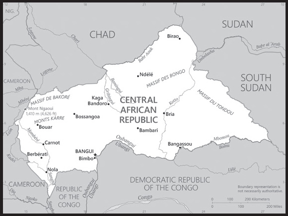
INTRODUCTION
Background: The Central African Republic (CAR) is a perennially weak state that sits at the crossroads of ethnic and linguistic groups in the center of the African continent. Among the last areas of Sub-Saharan Africa to be drawn into the world economy, its introduction into trade networks around the early 1700s fostered significant competition among its population. The local population sought to benefit from the lucrative Atlantic, trans-Saharan, and Indian Ocean trade in enslaved people and ivory. Slave raids aided by the local populations fostered animosity between ethnic groups that remains today. The territory was established as a French colony named Ubangui-Shari in 1903, and France modeled its administration of the colony after the Belgian Congo, subcontracting control of the territory to private companies that collected rubber and ivory. Although France banned the domestic slave trade in CAR in the 1910s, the private companies continued to exploit the population through forced labor. The colony of Ubangi-Shari gained independence from France as the Central African Republic in August 1960, but the death of independence leader Barthelemy BOGANDA six months prior led to an immediate struggle for power.
CAR’s political history has since been marred by a series of coups, the first of which brought Jean-Bedel BOKASSA to power in 1966. BOKASSA’s regime was characterized by widespread corruption and an intolerance of opposition, which manifested in the disappearances of many who challenged BOKASSA’s rule. In an effort to prolong his mandate, he named himself emperor in 1976 and changed the country’s name to the Central African Empire. His regime’s economic mismanagement culminated in widespread student protests in early 1979 that were violently suppressed by security forces. BOKASSA, rumored to have participated in the killing of some young students after the protests, fell out of favor with the international community and was overthrown in a French-backed coup in 1979. After BOKASSA’s departure, the country’s name once again became the Central African Republic.
CAR’s fifth coup in March 2013 unseated President Francois BOZIZE after a mainly Muslim rebel coalition named the Seleka seized the capital and forced BOZIZE, who himself had taken power in a coup in 2003, to flee the country. Widespread abuses by the Seleka spurred the formation of mainly Christian self-defense groups that called themselves the anti-Balaka, which have also committed human rights abuses against Muslim populations in retaliation. Since the rise of the self-defense groups, conflict in CAR has become increasingly ethnoreligious-based, although focused on identity as opposed to religious ideology. Elections organized by a transitional government in early 2016 installed independent candidate Faustin-Archange TOUADERA as president; he was reelected in December 2020. A peace agreement signed in February 2019 between the government and the main armed factions has had little effect, and armed groups remain in control of large swaths of the country’s territory.
GEOGRAPHY
Location: Central Africa, north of Democratic Republic of the Congo
Geographic coordinates: 7 00 N, 21 00 E
Map references: Africa
Area: total: 622,984 sq km
land: 622,984 sq km
water: 0 sq km
comparison ranking: total 47
Area - comparative: slightly smaller than Texas; about four times the size of Georgia
Land boundaries: total: 5,920 km
border countries (5): Cameroon 901 km; Chad 1556 km; Democratic Republic of the Congo 1,747 km, Republic of the Congo 487 km; South Sudan 1055 km; Sudan 174 km
Coastline: 0 km (landlocked)
Maritime claims: none (landlocked)
Climate: tropical; hot, dry winters; mild to hot, wet summers
Terrain: vast, flat to rolling plateau; scattered hills in northeast and southwest
Elevation: highest point: Mont Ngaoui 1,410 m
lowest point: Oubangui River 335 m
mean elevation: 635 m
Natural resources: diamonds, uranium, timber, gold, oil, hydropower
Land use: agricultural land: 8.1% (2018 est.)
arable land: 2.9% (2018 est.)
permanent crops: 0.1% (2018 est.)
permanent pasture: 5.1% (2018 est.)
forest: 36.2% (2018 est.)
other: 55.7% (2018 est.)
Irrigated land: 10 sq km (2012)
Major rivers (by length in km): Oubangui (Ubangi) river [s] (shared with Democratic Republic of Congo and Republic of Congo [m]) - 2,270 km
note – [s] after country name indicates river source; [m] after country name indicates river mouth
Major watersheds (area sq km): Atlantic Ocean drainage: Congo (3,730,881 sq km), (Mediterranean Sea) Nile (3,254,853 sq km) Internal (endorheic basin) drainage: Lake Chad (2,497,738 sq km)
Major aquifers: Congo Basin, Lake Chad Basin
Population distribution: majority of residents live in the western and central areas of the country, especially in and around the capital of Bangui as shown in this population distribution map
Natural hazards: hot, dry, dusty harmattan winds affect northern areas; floods are common
Geography - note: landlocked; almost the precise center of Africa
PEOPLE AND SOCIETY
Population: 5,552,228 (2023 est.)
comparison ranking: 119
Nationality: noun: Central African(s)
adjective: Central African
Ethnic groups: Baya 28.8%, Banda 22.9%, Mandjia 9.9%, Sara 7.9%, M’Baka-Bantu 7.9%, Arab-Fulani (Peuhl) 6%, Mbum 6%, Ngbanki 5.5%, Zande-Nzakara 3%, other Central African Republic ethnic groups 2%, non-Central African Republic ethnic groups .1% (2003 est.)
Languages: French (official), Sangho (lingua franca and national language), tribal languages
Religions: Christian 89%, Muslim 9%, folk religion 1%, unaffiliated 1% (2020 est.)
note: animistic beliefs and practices strongly influence the Christian majority
Demographic profile: The Central African Republic’s (CAR) humanitarian crisis has worsened since the coup of March 2013. CAR’s high mortality rate and low life expectancy are attributed to elevated rates of preventable and treatable diseases (including malaria and malnutrition), an inadequate health care system, precarious food security, and armed conflict. Some of the worst mortality rates are in western CAR’s diamond mining region, which has been impoverished because of government attempts to control the diamond trade and the fall in industrial diamond prices. To make matters worse, the government and international donors have reduced health funding in recent years. The CAR’s weak educational system and low literacy rate have also suffered as a result of the country’s ongoing conflict. Schools are closed, qualified teachers are scarce, infrastructure, funding, and supplies are lacking and subject to looting, and many students and teachers have been displaced by violence.
Rampant poverty, human rights violations, unemployment, poor infrastructure, and a lack of security and stability have led to forced displacement internally and externally. Since the political crisis that resulted in CAR’s March 2013 coup began in December 2012, approximately 600,000 people have fled to Chad, the Democratic Republic of the Congo, and other neighboring countries, while another estimated 515,000 were displaced internally as of December 2022. The UN has urged countries to refrain from repatriating CAR refugees amid the heightened lawlessness.
(2019)
Age structure: 0-14 years: 38.84% (male 1,104,007/female 1,052,411)
15-64 years: 57.71% (male 1,577,102/female 1,627,133)
65 years and over: 3.45% (2023 est.) (male 83,431/female 108,144)
Dependency ratios: total dependency ratio: 102.8
youth dependency ratio: 97.7
elderly dependency ratio: 5.1
potential support ratio: 19.7 (2021 est.)
Median age: total: 20 years (2020)
male: 19.7 years
female: 20.3 years
comparison ranking: total 196
Population growth rate: 1.77% (2023 est.)
comparison ranking: 51
Birth rate: 32.37 births/1,000 population (2023 est.)
comparison ranking: 23
Death rate: 11.51 deaths/1,000 population (2023 est.)
comparison ranking: 17
Net migration rate: -3.16 migrant(s)/1,000 population (2023 est.)
comparison ranking: 182
Population distribution: majority of residents live in the western and central areas of the country, especially in and around the capital of Bangui as shown in this population distribution map
Urbanization: urban population: 43.6% of total population (2023)
rate of urbanization: 3.32% annual rate of change (2020-25 est.)
Major urban areas - population: 958,000 BANGUI (capital) (2023)
Sex ratio: at birth: 1.03 male(s)/female
0-14 years: 1.05 male(s)/female
15-64 years: 0.97 male(s)/female
65 years and over: 0.77 male(s)/female
total population: 0.99 male(s)/female (2023 est.)
Maternal mortality ratio: 835 deaths/100,000 live births (2020 est.)
comparison ranking: 4
Infant mortality rate: total: 81.74 deaths/1,000 live births (2023 est.)
male: 87.69 deaths/1,000 live births
female: 75.61 deaths/1,000 live births
comparison ranking: total 3
Life expectancy at birth: total population: 55.96 years (2023 est.)
male: 54.64 years
female: 57.31 years
comparison ranking: total population 226
Total fertility rate: 3.99 children born/woman (2023 est.)
comparison ranking: 27
Gross reproduction rate: 1.97 (2023 est.)
Contraceptive prevalence rate: 17.8% (2019)
Drinking water source: improved: urban: 83.9% of population
rural: 47.5% of population
total: 62.9% of population
unimproved: urban: 16.1% of population
rural: 52.5% of population
total: 37.1% of population (2020 est.)
Current health expenditure: 9.4% of GDP (2020)
Physicians density: 0.07 physicians/1,000 population (2018)
Hospital bed density: 1 beds/1,000 population (2011)
Sanitation facility access: improved: urban: 53.8% of population
rural: 12.4% of population
total: 29.9% of population
unimproved: urban: 46.2% of population
rural: 87.6% of population
total: 70.1% of population (2020 est.)
Major infectious diseases: degree of risk: very high (2023)
food or waterborne diseases: bacterial and protozoal diarrhea, hepatitis A and E, and typhoid fever
vectorborne diseases: malaria and dengue fever
water contact diseases: schistosomiasis
animal contact diseases: rabies
note: on 31 August 2023, the US Centers for Disease Control and Prevention (CDC) issued a Travel Alert for polio in Africa; the Central African Republic is currently considered a high risk to travelers for circulating vaccine-derived polioviruses (cVDPV); vaccine-derived poliovirus (VDPV) is a strain of the weakened poliovirus that was initially included in oral polio vaccine (OPV) and that has changed over time and behaves more like the wild or naturally occurring virus; this means it can be spread more easily to people who are unvaccinated against polio and who come in contact with the stool or respiratory secretions, such as from a sneeze, of an “infected” person who received oral polio vaccine; the CDC recommends that before any international travel, anyone unvaccinated, incompletely vaccinated, or with an unknown polio vaccination status should complete the routine polio vaccine series; before travel to any high-risk destination, the CDC recommends that adults who previously completed the full, routine polio vaccine series receive a single, lifetime booster dose of polio vaccine
Obesity - adult prevalence rate: 7.5% (2016)
comparison ranking: 159
Alcohol consumption per capita: total: 0.94 liters of pure alcohol (2019 est.)
beer: 0.55 liters of pure alcohol (2019 est.)
wine: 0.04 liters of pure alcohol (2019 est.)
spirits: 0.02 liters of pure alcohol (2019 est.)
other alcohols: 0.33 liters of pure alcohol (2019 est.)
comparison ranking: total 152
Children under the age of 5 years underweight: 20.5% (2019)
comparison ranking: 15
Currently married women (ages 15-49): 64.7% (2023 est.)
Child marriage: women married by age 15: 25.8%
women married by age 18: 61%
men married by age 18: 17.1% (2019 est.)
Education expenditures: 2.2% of GDP (2020 est.)
comparison ranking: 182
Literacy: definition: age 15 and over can read and write
total population: 37.4%
male: 49.5%
female: 25.8% (2018)
School life expectancy (primary to tertiary education): total: 7 years
male: 8 years
female: 6 years (2012)
Youth unemployment rate (ages 15-24): total: 11.8% (2021 est.)
male: 10.6%
female: 13.1%
comparison ranking: total 137
ENVIRONMENT
Environment - current issues: water pollution; tap water is not potable; poaching and mismanagement have diminished the country’s reputation as one of the last great wildlife refuges; desertification; deforestation; soil erosion
Environment - international agreements: party to: Biodiversity, Climate Change, Climate Change-Kyoto Protocol, Climate Change-Paris Agreement, Comprehensive Nuclear Test Ban, Desertification, Endangered Species, Hazardous Wastes, Nuclear Test Ban, Ozone Layer Protection, Tropical Timber 2006, Wetlands
signed, but not ratified: Law of the Sea
Climate: tropical; hot, dry winters; mild to hot, wet summers
Land use: agricultural land: 8.1% (2018 est.)
arable land: 2.9% (2018 est.)
permanent crops: 0.1% (2018 est.)
permanent pasture: 5.1% (2018 est.)
forest: 36.2% (2018 est.)
other: 55.7% (2018 est.)
Urbanization: urban population: 43.6% of total population (2023)
rate of urbanization: 3.32% annual rate of change (2020-25 est.)
Food insecurity: exceptional shortfall in aggregate food production/supplies: due to internal conflict and high food prices - according to the latest analysis, issued in November 2022, the number of people in Crisis and above is estimated at 2.7 million between September 2022 and March 2023; this is mainly attributed to the impact of civil insecurity and high food prices; persisting insecurity and population displacements continue to affect agricultural activities and limit farmers’ access to crop growing areas and agricultural inputs; elevated international prices of fuel and fertilizers, largely imported, have reportedly led to a lower use of agricultural inputs in 2022, especially among smallholder farmers, with a negative impact on yields (2023)
Revenue from forest resources: 8.99% of GDP (2018 est.)
comparison ranking: 5
Revenue from coal: 0% of GDP (2018 est.)
comparison ranking: 71
Air pollutants: particulate matter emissions: 27.2 micrograms per cubic meter (2019 est.)
carbon dioxide emissions: 0.3 megatons (2016 est.)
methane emissions: 22.44 megatons (2020 est.)
Waste and recycling: municipal solid waste generated annually: 1,105,983 tons (2014 est.)
Major rivers (by length in km): Oubangui (Ubangi) river [s] (shared with Democratic Republic of Congo and Republic of Congo [m]) - 2,270 km
note – [s] after country name indicates river source; [m] after country name indicates river mouth
Major watersheds (area sq km): Atlantic Ocean drainage: Congo (3,730,881 sq km), (Mediterranean Sea) Nile (3,254,853 sq km) Internal (endorheic basin) drainage: Lake Chad (2,497,738 sq km)
Major aquifers: Congo Basin, Lake Chad Basin
Total water withdrawal: municipal: 60 million cubic meters (2020 est.)
industrial: 10 million cubic meters (2020 est.)
agricultural: 400,000 cubic meters (2017 est.)
Total renewable water resources: 141 billion cubic meters (2020 est.)
GOVERNMENT
Country name: conventional long form: Central African Republic
conventional short form: none
local long form: Republique Centrale Africaine
local short form: none
former: Ubangi-Shari, Central African Empire
abbreviation: CAR
etymology: self-descriptive name specifying the country’s location on the continent; “Africa” is derived from the Roman designation of the area corresponding to present-day Tunisia “Africa terra,” which meant “Land of the Afri” (the tribe resident in that area), but which eventually came to mean the entire continent
Government type presidential republic
Capital: name: Bangui
geographic coordinates: 4 22 N, 18 35 E
time difference: UTC+1 (6 hours ahead of Washington, DC, during Standard Time)
etymology: established as a French settlement in 1889 and named after its location on the northern bank of the Ubangi River; the Ubangi itself was named from the native word for the “rapids” located beside the outpost, which marked the end of navigable water north from Brazzaville
Administrative divisions: 14 prefectures (prefectures, singular - prefecture), 2 economic prefectures* (prefectures economiques, singular - prefecture economique), and 1 commune**; Bamingui-Bangoran, Bangui**, Basse-Kotto, Haute-Kotto, Haut-Mbomou, Kemo, Lobaye, Mambere-Kadei, Mbomou, Nana-Grebizi*, Nana-Mambere, Ombella-Mpoko, Ouaka, Ouham, Ouham- Pende, Sangha-Mbaere*, Vakaga
Independence: 13 August 1960 (from France)
National holiday: Republic Day, 1 December (1958)
Constitution: history: several previous; latest constitution passed by a national referendum on 30 July 2023 and validated by the Constitutional Court on 21 August 2023; note - the new constitution was proposed by President Faustin-Archange Touadéra, extended the presidential term from 5 to 7 years, removed term limits, and will allow President Touadéra to run again in 2025; opposition parties denounced the changes, claiming they were created to facilitate a “life precedency” for Touadéra
amendments: proposals require support of the government, two thirds of the National Council of Transition, and assent by the “Mediator of the Central African” crisis; passage requires at least three-fourths majority vote by the National Council membership; non-amendable constitutional provisions include those on the secular and republican form of government, fundamental rights and freedoms, amendment procedures, or changes to the authorities of various high-level executive, parliamentary, and judicial officials
Legal system: civil law system based on the French model
International law organization participation: has not submitted an ICJ jurisdiction declaration; accepts ICCt jurisdiction
Citizenship: citizenship by birth: no
citizenship by descent only: least one parent must be a citizen of the Central African Republic
dual citizenship recognized: yes
residency requirement for naturalization: 35 years
Suffrage: 18 years of age; universal
Executive branch: chief of state: President Faustin-Archange TOUADERA (since 30 March 2016)
head of government: Prime Minister Felix MOLOUA (since 7 February 2022); note - Prime Minister Henri-Marie DONDRA resigned on 2 February 2022
cabinet: Council of Ministers appointed by the president
elections/appointments: president directly elected for 5-year term; election last held 27 December 2020 (next to be held in December 2025); constitutional referendum in July 2023 removed term limits and will institute 7-year terms; note - Central African Republic held presidential and partial legislative elections on 27 December 2020; voting was disrupted in some areas, delaying the first round of legislative elections until 14 March 2021; constituencies that did vote on 27 December 2020 held runoff elections for their legislators
election results: 2020: Faustin-Archange TOUADERA reelected president in first round; percent of vote - Faustin-Archange TOUADERA (independent) 53.9%, Anicet Georges DOLOGUELE (URCA) 21%, other 25.1%
2015: Faustin-Archange TOUADERA elected president in the second round; percent of vote in first round - Anicet- Georges DOLOGUELE (URCA) 23.7%, Faustin-Archange TOUADERA (independent) 19.1%, Desire KOLINGBA (RDC) 12%, Martin ZIGUELE (MLPC) 11.4%, other 33.8%; percent of vote in second round - Faustin-Archange TOUADERA 62.7%, Anicet-Georges DOLOGUELE 37.3%
Legislative branch: description: unicameral National Assembly or Assemblee Nationale (140 seats; members directly elected in single-seat constituencies by absolute majority vote with a second round if needed; members serve 5-year terms)
elections: last held in December 2020 through July 2021 (next to be held 31 December 2025); note - on 27 December 2020, the day of first round elections, voting in many electoral areas was disrupted by armed groups; on 13 February 2021, President TOUADERA announced that new first round elections would be held on 27 February for those areas controlled by armed groups and the second round on 14 March; ultimately, two additional rounds were held on 23 May and 25 July 2021 in areas that continued to suffer from election security problems
election results: December 2020 to July 2021 election: percent of vote by party - NA; seats by party - MCU 63, MOUNI 9, URCA 7, MLPC 7, RDC 5, KNK 3, PATRIE 3, CDE 2, RDD 2, MDD 2, PGD 2, PAD 2, CANE 2, other 11, independents 20; composition as of March 2022 - men 122, women 18, percent of women 12.9%; note - several members of other parties and independent candidates joined the MCU following the opening session of the National Assembly; as of 21 September 2021, the MCU held 86 seats
Judicial branch: highest court(s): Supreme Court or Cour Supreme (consists of NA judges); Constitutional Court (consists of 9 judges, at least 3 of whom are women)
judge selection and term of office: Supreme Court judges appointed by the president; Constitutional Court judge appointments - 2 by the president, 1 by the speaker of the National Assembly, 2 elected by their peers, 2 are advocates elected by their peers, and 2 are law professors elected by their peers; judges serve 7-year non-renewable terms
subordinate courts: high courts; magistrates’ courts
Political parties and leaders: Action Party for Development or PAD
African Party for Radical Transformation and Integration of States or PATRIE [Crepin MBOLI-GOUMBA]
Alliance for Democracy and Progress or ADP
Be Africa ti e Kwe (also known as Central Africa for Us All or BTK)
Central African Democratic Rally or RDC
Central African Party for Integrated Development or PCDI
Democratic Movement for the Renewal and Evolution of Central Africa or MDREC
Kodro Ti Mo Kozo Si Movement or MKMKS
Movement for Democracy and Development or MDD [Louis PAPÉNIAH]
Movement for the Liberation of the Central African People or MLPC [Martin ZIGUÉLÉ]
National Convergence (also known as Kwa Na Kwa or KNK) [Christian GUÉNÉBEM-DEDIZOUM]
National Movement of Independents or MOUNI
National Union for Democracy and Progress or UNDP [Michel AMINE]
National Union of Republican Democrats or UNADER
New Impetus for Central Africa or CANE
Party for Democracy and Solidarity - Kélémba or KPDS
Party for Democratic Governance or PGD
Path of Hope or CDE [Karim MECKASSOUA]
Renaissance for Sustainable Development or RDD
Socialist Party or PS
Transformation Through Action Initiative or ITA
Union for Central African Renewal or URCA [Anicet-Georges DOLOGUÉLÉ]
Union for Renaissance and Development or URD
United Hearts Movement or MCU [Faustin-Archange TOUADÉRA]
note: only parties with seats in the Parliament included
International organization participation: ACP, AfDB, AU, BDEAC, CEMAC, EITI (compliant country) (suspended), FAO, FZ, G-77, IAEA, IBRD, ICAO, ICCt, ICRM, IDA, IFAD, IFC, IFRCS, ILO, IMF, Interpol, IOC, IOM, ITSO, ITU, ITUC (NGOs), LCBC, MIGA, NAM, OIC (observer), OIF, OPCW, UN, UNCTAD, UNESCO, UNIDO, UNWTO, UPU, WCO, WHO, WIPO, WMO, WTO
Diplomatic representation in the US: chief of mission: Ambassador Martial NDOUBOU (since 17 September 2018)
chancery: 2704 Ontario Road NW, Washington, DC 20009
telephone: [1] (202) 483-7800
FAX: [1] (202) 332-9893
email address and website:
centrafricwashington@yahoo.com
Diplomatic representation from the US: chief of mission: Ambassador Patricia A. MAHONEY (since 8 April 2022)
embassy: Avenue David Dacko, Bangui
mailing address: 2060 Bangui Place, Washington DC 20521-2060
telephone: [236] 2161-0200
FAX: [236] 2161-4494
email address and website:
Flag description: four equal horizontal bands of blue (top), white, green, and yellow with a vertical red band in center; a yellow five-pointed star to the hoist side of the blue band; banner combines the Pan-African and French flag colors; red symbolizes the blood spilled in the struggle for independence, blue represents the sky and freedom, white peace and dignity, green hope and faith, and yellow tolerance; the star represents aspiration towards a vibrant future
National symbol(s): elephant; national colors: blue, white, green, yellow, red
National anthem: name: “La Renaissance” (The Renaissance)
lyrics/music: Barthelemy BOGANDA/Herbert PEPPER
note: adopted 1960; Barthelemy BOGANDA wrote the anthem’s lyrics and was the first prime minister of the autonomous French territory
National heritage: total World Heritage Sites: 2 (natural)
selected World Heritage Site locales: Manovo-Gounda St. Floris National Park; Sangha Trinational Forest
ECONOMY
Economic overview: enormous natural resources; extreme poverty; weak public institutions and infrastructure; political and gender-based violence have led to displacement of roughly 25% of population; Bangui-Douala corridor blockade reduced activity and tax collection; strong agricultural performance offset COVID-19 downturn
Real GDP (purchasing power parity): $4.483 billion (2019 est.)
$4.354 billion (2018 est.)
$4.195 billion (2017 est.)
note: data are in 2017 dollars
comparison ranking: 182
Real GDP growth rate: 0.9% (2021 est.)
0.9% (2020 est.)
3.1% (2019 est.)
comparison ranking: 187
Real GDP per capita: $800 (2021 est.)
$800 (2020 est.)
$900 (2019 est.)
note: data are in 2017 dollars
comparison ranking: 228
GDP (official exchange rate)
$1.937 billion (2017 est.)
Inflation rate (consumer prices): 4.26% (2021 est.)
1.71% (2020 est.)
2.69% (2019 est.)
comparison ranking: 83
GDP - composition, by sector of origin
agriculture: 43.2% (2017 est.)
industry: 16% (2017 est.)
services: 40.8% (2017 est.)
comparison rankings: services 208; industry 173; agriculture 6
GDP - composition, by end use
household consumption: 95.3% (2017 est.)
government consumption: 8.5% (2017 est.)
investment in fixed capital: 13.7% (2017 est.)
investment in inventories: 0% (2017 est.)
exports of goods and services: 12% (2017 est.)
imports of goods and services: -29.5% (2017 est.)
Agricultural products: cassava, yams, groundnuts, taro, bananas, sugar cane, beef, maize, plantains, milk
Industries: gold and diamond mining, logging, brewing, sugar refining
Industrial production growth rate: -0.24% (2021 est.)
comparison ranking: 158
Labor force: 2.015 million (2021 est.)
comparison ranking: 124
Unemployment rate: 6.57% (2021 est.)
6.36% (2020 est.)
5.62% (2019 est.)
comparison ranking: 120
Youth unemployment rate (ages 15-24): total: 11.8% (2021 est.)
male: 10.6%
female: 13.1%
comparison ranking: total 137
Population below poverty line: 62% (2008 est.)
Gini Index coefficient - distribution of family income: 56.2 (2008 est.)
comparison ranking: 4
Household income or consumption by percentage share: lowest 10%: 2.1%
highest 10%: 33% (2003)
Budget: revenues: $418 million (2019 est.)
expenditures: $385 million (2019 est.)
Budget surplus (+) or deficit (-): -0.9% (of GDP) (2017 est.)
comparison ranking: 72
Public debt: 52.9% of GDP (2017 est.)
56% of GDP (2016 est.)
comparison ranking: 98
Taxes and other revenues: 8.71% (of GDP) (2020 est.)
comparison ranking: 203
Fiscal year: calendar year
Current account balance: -$163 million (2017 est.)
-$97 million (2016 est.)
comparison ranking: 98
Exports: $113.7 million (2017 est.)
$101.5 million (2016 est.)
note: Data are in current year dollars and do not include illicit exports or re-exports.
comparison ranking: 208
Exports - partners: China 41%, United Arab Emirates 19%, France 7% (2019)
Exports - commodities: gold, lumber, diamonds, large construction vehicles, rum (2021)
Imports: $393.1 million (2017 est.)
$342.2 million (2016 est.)
comparison ranking: 206
Imports - partners: India 18%, France 12%, United States 11%, China 9%, Netherlands 7%, Belgium 7%, Malta 6% (2019)
Imports - commodities: refined petroleum, packaged medicines, natural gas, broadcasting equipment, second-hand clothing (2019)
Reserves of foreign exchange and gold: $350.305 million (31 December 2019 est.)
$361.797 million (31 December 2018 est.)
$362.717 million (31 December 2017 est.)
comparison ranking: 174
Debt - external: $779.9 million (31 December 2017 est.)
$691.5 million (31 December 2016 est.)
comparison ranking: 171
Exchange rates: Cooperation Financiere en Afrique Centrale francs (XAF) per US dollar -
Exchange rates:: 554.531 (2021 est.)
575.586 (2020 est.)
585.911 (2019 est.)
555.446 (2018 est.)
580.657 (2017 est.)
ENERGY
Electricity access: population without electricity: 5 million (2020)
electrification - total population: 15.6% (2021)
electrification - urban areas: 34.6% (2021)
electrification - rural areas: 1.5% (2021)
Electricity: installed generating capacity: 38,000 kW (2020 est.)
consumption: 140.44 million kWh (2019 est.)
exports: 0 kWh (2019 est.)
imports: 0 kWh (2019 est.)
transmission/distribution losses: 10.5 million kWh (2019 est.)
comparison rankings: installed generating capacity 197; transmission/distribution losses 195; imports 195; exports 193; consumption 190
Electricity generation sources: fossil fuels: 0.7% of total installed capacity (2020 est.)
hydroelectricity: 99.3% of total installed capacity (2020 est.)
Coal: proven reserves: 3 million metric tons (2019 est.)
Petroleum: total petroleum production: 0 bbl/day (2021 est.)
refined petroleum consumption: 2,000 bbl/day (2019 est.)
Refined petroleum products - imports: 2,799 bbl/day (2015 est.)
comparison ranking: 185
Carbon dioxide emissions: 285,000 metric tonnes of CO2 (2019 est.)
from petroleum and other liquids: 285,000 metric tonnes of CO2 (2019 est.)
comparison ranking: total emissions 198
Energy consumption per capita: 1.121 million Btu/person (2019 est.)
comparison ranking: 193
COMMUNICATIONS
Telephones - fixed lines: total subscriptions: 2,000 (2021 est.)
subscriptions per 100 inhabitants: (2021 est.) less than 1
comparison ranking: total subscriptions 215
Telephones - mobile cellular: total subscriptions: 1.8 million (2021 est.)
subscriptions per 100 inhabitants: 34 (2021 est.)
comparison ranking: total subscriptions 155
Telecommunication systems: general assessment: given the poor fixed-line infrastructure in most countries across Africa, voice and data services across the region are greatly dependent on mobile networks; in the majority of markets, including those with better developed fixed infrastructure such as South Africa, Nigeria, and Kenya, up to 98% of all voice and data connections are via mobile networks; during the last two to three years, national governments and telecom regulators have striven to improve fixed infrastructure with the wider aim of developing economic growth based on digital services and connectivity; this work is principally focused on delivering fiber-based connectivity; since the amount of copper infrastructure (DSL or HFC) used for broadband is so negligible, governments and private firms, including telcos are investing in fiber rather than in older technologies; while supporting broadband to premises, health centers, and government buildings, the new fiber infrastructure is mainly being deployed to provide mobile platforms and to support the rapid growth in data traffic (2022)
domestic: very limited telephone service with less than 1 fixed-line connection per 100 persons; 34 per 100 mobile-cellular subscribers (2020)
international: country code - 236; satellite earth station - 1 Intelsat (Atlantic Ocean)
Broadcast media: government-owned network, Radiodiffusion Television Centrafricaine, provides limited domestic TV broadcasting; state-owned radio network is supplemented by a small number of privately owned broadcast stations as well as a few community radio stations; transmissions of at least 2 international broadcasters are available (2017)
Internet country code: .cf
Internet users: total: 605,000 (2021 est.)
percent of population: 11% (2021 est.)
comparison ranking: total 165
Broadband - fixed subscriptions: total: 499 (2019 est.) Data available for 2019 only.
subscriptions per 100 inhabitants: 0.01 (2019 est.)
comparison ranking: total 210
TRANSPORTATION
National air transport system: number of registered air carriers: 2 (2020)
inventory of registered aircraft operated by air carriers: 2
annual passenger traffic on registered air carriers: 46,364 (2015)
annual freight traffic on registered air carriers: 0 (2015) mt-km
Civil aircraft registration country code prefix: TL
Airports: 39 (2021)
comparison ranking: total 106
Airports - with paved runways: 1
note: paved runways have a concrete or asphalt surface but not all have facilities for refueling, maintenance, or air traffic control; the length of a runway required for aircraft to safely operate depends on a number of factors including the type of aircraft, the takeoff weight (including passengers, cargo, and fuel), engine types, flap settings, landing speed, elevation of the airport, and average maximum daily air temperature; paved runways can reach a length of 5,000 m (16,000 ft.), but the “typical” length of a commercial airline runway is between 2,500-4,000 m (8,000-13,000 ft.)
Airports - with unpaved runways: 37
note: unpaved runways have a surface composition such as grass or packed earth and are most suited to the operation of light aircraft; unpaved runways are usually short, often less than 1,000 m (3,280 ft.) in length; airports with unpaved runways often lack facilities for refueling, maintenance, or air traffic control
Roadways: total: 24,000 km (2018)
paved: 700 km (2018)
unpaved: 23,300 km (2018)
comparison ranking: total 105
Waterways: 2,800 km (2011) (the primary navigable river is the Ubangi, which joins the River Congo; it was the traditional route for the export of products because it connected with the Congo-Ocean railway at Brazzaville; because of the warfare on both sides of the River Congo from 1997, importers and exporters preferred routes through Cameroon)
comparison ranking: 36
Ports and terminals: river port(s): Bangui (Oubangui)
Nola (Sangha)
MILITARY AND SECURITY
Military and security forces: Central African Armed Forces (Forces Armees Centrafricaines, FACA): Army (includes an air squadron, Escadrille Centrafricaine)
Ministry of Interior: National Gendarmerie (Gendarmerie Nationale), National Police (2023)
note 1: the Special Republican Protection Group (Groupement Spécial Chargé de la Protection Républicaine or GSPR) is part of the Army per a March 2022 decree, but reports to the president; the GSPR provides protection to the head of state
note 2: in 2019-2021, the CAR created three Mixed Special Security units (Unités Spéciales Mixtes de Sécurité or USMS), regionally based battalion-sized units comprised of about 40% government and 60% rebel soldiers created to provide security along transportation corridors and at mining sites; the units are intended to be transitional in nature with a scheduled deployment time of two years; in addition, since mid-2021 the FACA have frequently recruited local militias, mostly former anti-balaka fighters, whom they pay to help track and attack rebels hiding in the bush
Military expenditures: 1.7% of GDP (2022 est.)
1.8% of GDP (2021 est.)
1.8% of GDP (2020 est.)
1.7% of GDP (2019 est.)
1.4% of GDP (2018 est.)
comparison ranking: 77
Military and security service personnel strengths: information varies; up to 15,000 FACA troops (2023)
Military equipment inventories and acquisitions: the FACA is lightly armed; most of the military’s heavy weapons and equipment were destroyed or captured during the 2012–2014 civil war; prior to the war, most of its equipment was of French, Russian, or Soviet origin; in recent years, it has received small amounts of secondhand equipment from China and Russia (2023)
note: since 2013, CAR has been under a UNSC arms embargo; the embargo bans all supplies of arms and related materiel to the country except to the CAR security forces if approved in advance by the relevant UN Sanctions Committee; in 2023, UNSC took a step towards relaxing the arms embargo by granting permission for weaponry to be supplied to government forces
Military service age and obligation: 18 years of age for military service; no conscription (2022)
Military - note: the 2013 coup resulted in the institutional collapse of the FACA; its forces were overwhelmed and forced to flee to neighboring countries; it has been estimated that only 10% of the FACA returned after the coup, and it has struggled to rebuild in the years of instability since, despite considerable foreign assistance; significant portions of the country remain outside state control and are ungoverned, with the presence of multiple armed actors creating insecurity in much of the country
in late 2020 and early 2021, the Coalition des Patriotes pour le Change (CPC), a loose coalition of armed groups comprised largely of former Seleka and anti-Balaka fighters, attacked the capital Bangui; CAR Government forces, along with Russian private military contractors and Rwandan troops, repelled the attack but have not been able to stabilize the country; the CPC has retreated to its rear bases and into neighboring countries and continued conducting attacks; other armed groups are also active; forces on both sides have been accused of abuses and atrocities in the fighting
in 2018, the UN Security Council approved Russian security assistance for the CAR to help train and advise FACA personnel, as well as transport them to operational areas, provide logistical support, and assist with medical evacuation; in addition to teams of military trainers, Russia sent private military contractors, and as of 2023, as many as 2,000 were providing assistance to the FACA, as well as performing other security roles such as guarding mines and government officials; some Russian contractors and the CAR forces they supported have been accused of carrying out indiscriminate killings, using excessive force against civilians, and looting
the UN Multidimensional Integrated Stabilization Mission in the Central African Republic (MINUSCA) has operated in the country since 2014; its mission includes providing security, protecting civilians, facilitating humanitarian assistance, disarming and demobilizing armed groups, and supporting the country’s fragile transitional government; as of early 2023, MINUSCA had almost 17,000 personnel
the European Union Training Mission in the Central African Republic (EUTM-RCA) has operated in the country since 2016, providing advice, training, and educational programs to the country’s security forces; since 2016, the EU mission has trained 5 territorial infantry battalions and 1 amphibious infantry battalion; the mission suspended operational training in 2021; France also provided assistance to the FACA before suspending its support, also in 2021 (2023)
TRANSNATIONAL ISSUES
Disputes - international: Central African Republic-South Sudan: periodic violent skirmishes persist among related pastoral populations along the border with South Sudan over water and grazing rights
Central African Republic-Sudan: periodic violent skirmishes persist among related pastoral populations along the border with Sudan over water and grazing rights
Refugees and internally displaced persons: refugees (country of origin): 13,844 (Sudan) (refugees since 15 April 2023), 6,682 (Democratic Republic of Congo) (2023)
IDPs: 490,868 (clashes between army and rebel groups since 2005; tensions between ethnic groups) (2023)