INTRODUCTION
Background: For centuries prior to colonization in the 19th century, the archipelago of the Comoros in the Indian Ocean, served as a key node in the maritime trade networks that connected the Middle East, India, and eastern African regions. Composed of the islands of Anjouan, Mayotte, Moheli, and Grande Comore, Comoros spent most of the 20th century as a colonial outpost until it declared independence from France on 6 July 1975. Residents of Mayotte, however, voted to remain in France, and the French Government now has classified it as a department of France. Since independence, Comoros has weathered approximately 20 realized and attempted coups resulting in prolonged political instability and stunted economic development. In 2002, President AZALI Assoumani became the first elected president following the completion of the Fomboni Accords, in which the islands of Grande Comore, Anjouan, and Moheli reached an agreement whereby the presidency would rotate among the islands every five years. This power-sharing agreement also included provisions allowing each island to maintain its local government. AZALI stepped down in 2006 and President Ahmed Abdallah Mohamed SAMBI was elected as president from Anjouan. In 2007, Mohamed BACAR effected Anjouan’s de-facto secession from the Union of the Comoros, refusing to step down when Comoros’ other islands held legitimate elections in July. The African Union (AU) initially attempted to resolve the political crisis by applying sanctions and a naval blockade to Anjouan, but in March 2008 the AU and Comoran soldiers seized the island. The island’s inhabitants generally welcomed the move. In May 2011, Ikililou DHOININE won the presidency in peaceful elections widely deemed to be free and fair. In closely contested elections in 2016, former President AZALI Assoumani won a second term, when the rotating presidency returned to Grande Comore. A referendum held in July 2018 - boycotted by the opposition parties - overwhelmingly approved a new constitution removing presidential term limits and the requirement for the presidency to rotate between the three main islands. In August 2018, President AZALI formed a new government and subsequently ran and was elected president in March 2019.
GEOGRAPHY
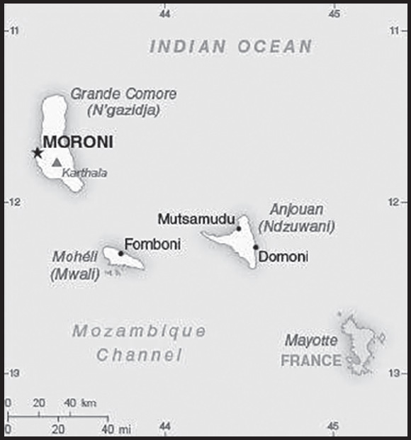
Location: Southern Africa, group of islands at the northern mouth of the Mozambique Channel, about two-thirds of the way between northern Madagascar and northern Mozambique
Geographic coordinates: 12 10 S, 44 15 E
Map references: Africa
Area: total: 2,235 sq km
land: 2,235 sq km
water: 0 sq km
comparison ranking: total 179
Area - comparative: slightly more than 12 times the size of Washington, DC
Land boundaries: total: 0 km
Coastline: 340 km
Maritime claims: territorial sea: 12 nm
exclusive economic zone: 200 nm
Climate: tropical marine; rainy season (November to May)
Terrain: volcanic islands, interiors vary from steep mountains to low hills
Elevation: highest point: Karthala 2,360 m
lowest point: Indian Ocean 0 m
Natural resources: fish
Land use: agricultural land: 84.4% (2018 est.)
arable land: 46.7% (2018 est.)
permanent crops: 29.6% (2018 est.)
permanent pasture: 8.1% (2018 est.)
forest: 1.4% (2018 est.)
other: 14.2% (2018 est.)
Irrigated land: 1.3 sq km (2012)
Population distribution: the capital city of Maroni, located on the western side of the island of Grande Comore, is the country’s largest city; however, of the three islands that comprise Comoros, it is Anjouan that is the most densely populated as shown in this population distribution map
Natural hazards: cyclones possible during rainy season (December to April); volcanic activity on Grand Comore
volcanism: Karthala (2,361 m) on Grand Comore Island last erupted in 2007; a 2005 eruption forced thousands of people to be evacuated and produced a large ash cloud
Geography - note: important location at northern end of Mozambique Channel; the only Arab League country that lies entirely in the Southern Hemisphere
PEOPLE AND SOCIETY
Population: 888,378 (2023 est.)
comparison ranking: 164
Nationality: noun: Comoran(s)
adjective: Comoran
Ethnic groups: Antalote, Cafre, Makoa, Oimatsaha, Sakalava
Languages: Arabic (official), French (official), Shikomoro (official; similar to Swahili) (Comorian)
Religions: Sunni Muslim 98%, other (including Shia Muslim, Roman Catholic, Jehovah’s Witness, Protestant) 2%
note: Sunni Islam is the state religion
Demographic profile: Comoros’ population is a melange of Arabs, Persians, Indonesians, Africans, and Indians, and the much smaller number of Europeans that settled on the islands between the 8th and 19th centuries, when they served as a regional trade hub. The Arab and Persian influence is most evident in the islands’ overwhelmingly Muslim majority – about 98% of Comorans are Sunni Muslims. The country is densely populated, averaging nearly 350 people per square mile, although this varies widely among the islands, with Anjouan being the most densely populated.
Given the large share of land dedicated to agriculture and Comoros’ growing population, habitable land is becoming increasingly crowded. The combination of increasing population pressure on limited land and resources, widespread poverty, and poor job prospects motivates thousands of Comorans each year to attempt to illegally migrate using small fishing boats to the neighboring island of Mayotte, which is a French territory. The majority of legal Comoran migration to France came after Comoros’ independence from France in 1975, with the flow peaking in the mid-1980s.
At least 150,000 to 200,000 people of Comoran citizenship or descent live abroad, mainly in France, where they have gone seeking a better quality of life, job opportunities, higher education (Comoros has no universities), advanced health care, and to finance elaborate traditional wedding ceremonies (aada). Remittances from the diaspora are an economic mainstay, in 2013 representing approximately 25% of Comoros’ GDP and significantly more than the value of its exports of goods and services (only 15% of GDP). Grand Comore, Comoros’ most populous island, is both the primary source of emigrants and the main recipient of remittances. Most remittances are spent on private consumption, but this often goes toward luxury goods and the aada and does not contribute to economic development or poverty reduction. Although the majority of the diaspora is now French-born with more distant ties to Comoros, it is unclear whether they will sustain the current level of remittances.
Age structure: 0-14 years: 33.45% (male 148,485/female 148,651)
15-64 years: 62% (male 264,023/female 286,805)
65 years and over: 4.55% (2023 est.) (male 17,696/female 22,718)
Dependency ratios: total dependency ratio: 74.1
youth dependency ratio: 66.6
elderly dependency ratio: 7.5
potential support ratio: 13.3 (2021 est.)
Median age: total: 20.9 years (2020)
male: 20.2 years
female: 21.5 years
comparison ranking: total 188
Population growth rate: 1.34% (2023 est.)
comparison ranking: 70
Birth rate: 22.06 births/1,000 population (2023 est.)
comparison ranking: 56
Death rate: 6.49 deaths/1,000 population (2023 est.)
comparison ranking: 136
Net migration rate: -2.22 migrant(s)/1,000 population (2023 est.)
comparison ranking: 172
Population distribution: the capital city of Maroni, located on the western side of the island of Grande Comore, is the country’s largest city; however, of the three islands that comprise Comoros, it is Anjouan that is the most densely populated as shown in this population distribution map
Urbanization: urban population: 30.1% of total population (2023)
rate of urbanization: 2.97% annual rate of change (2020-25 est.)
Major urban areas - population: 62,000 MORONI (capital) (2018)
Sex ratio: at birth: 1.03 male(s)/female
0-14 years: 1 male(s)/female
15-64 years: 0.92 male(s)/female
65 years and over: 0.78 male(s)/female
total population: 0.94 male(s)/female (2023 est.)
Mother’s mean age at first birth: 23 years (2012 est.)
note: data represents median age at first birth among women 25-49
Maternal mortality ratio: 217 deaths/100,000 live births (2020 est.)
comparison ranking: 43
Infant mortality rate: total: 56.01 deaths/1,000 live births (2023 est.)
male: 66.02 deaths/1,000 live births
female: 45.7 deaths/1,000 live births
comparison ranking: total 13
Life expectancy at birth: total population: 67.5 years (2023 est.)
male: 65.2 years
female: 69.87 years
comparison ranking: total population 192
Total fertility rate: 2.69 children born/woman (2023 est.)
comparison ranking: 60
Gross reproduction rate: 1.33 (2023 est.)
Contraceptive prevalence rate: 19.4% (2012)
Drinking water source: improved: urban: 97.4% of population
rural: 88.5% of population
total: 91% of population
unimproved: urban: 2.6% of population
rural: 11.5% of population
total: 8.9% of population (2017 est.)
Current health expenditure: 5.4% of GDP (2020)
Physicians density: 0.26 physicians/1,000 population (2018)
Sanitation facility access: improved: urban: 62.4% of population
rural: 43.6% of population
total: 49% of population
unimproved: urban: 37.6% of population
rural: 56.4% of population
total: 51% of population (2017 est.)
Obesity - adult prevalence rate: 7.8% (2016)
comparison ranking: 157
Alcohol consumption per capita: total: 0.18 liters of pure alcohol (2019 est.)
beer: 0.04 liters of pure alcohol (2019 est.)
wine: 0.07 liters of pure alcohol (2019 est.)
spirits: 0.07 liters of pure alcohol (2019 est.)
other alcohols: 0 liters of pure alcohol (2019 est.)
comparison ranking: total 173
Tobacco use: total: 20.3% (2020 est.)
male: 29.5% (2020 est.)
female: 11.1% (2020 est.)
comparison ranking: total 83
Currently married women (ages 15-49): 61.2% (2023 est.)
Education expenditures: 2.6% of GDP (2015 est.)
comparison ranking: 174
Literacy: definition: age 15 and over can read and write
total population: 62%
male: 67%
female: 56.9% (2021)
School life expectancy (primary to tertiary education): total: 11 years
male: 11 years
female: 11 years (2014)
Youth unemployment rate (ages 15-24): total: 21.7% (2021 est.)
male: 21.8%
female: 21.5%
comparison ranking: total 73
ENVIRONMENT
Environment - current issues: deforestation; soil degradation and erosion results from forest loss and from crop cultivation on slopes without proper terracing; marine biodiversity affected as soil erosion leads to the silting of coral reefs
Environment - international agreements: party to: Biodiversity, Climate Change, Climate Change-Kyoto Protocol, Climate Change-Paris Agreement, Comprehensive Nuclear Test Ban, Desertification, Endangered Species, Hazardous Wastes, Law of the Sea, Ozone Layer Protection, Ship Pollution, Wetlands
signed, but not ratified: none of the selected agreements
Climate: tropical marine; rainy season (November to May)
Land use: agricultural land: 84.4% (2018 est.)
arable land: 46.7% (2018 est.)
permanent crops: 29.6% (2018 est.)
permanent pasture: 8.1% (2018 est.)
forest: 1.4% (2018 est.)
other: 14.2% (2018 est.)
Urbanization: urban population: 30.1% of total population (2023)
rate of urbanization: 2.97% annual rate of change (2020-25 est.)
Revenue from forest resources: 1.39% of GDP (2018 est.)
comparison ranking: 46
Revenue from coal: 0% of GDP (2018 est.)
comparison ranking: 182
Air pollutants: particulate matter emissions: 14.37 micrograms per cubic meter (2019 est.)
carbon dioxide emissions: 0.2 megatons (2016 est.)
methane emissions: 0.19 megatons (2020 est.)
Waste and recycling: municipal solid waste generated annually: 91,013 tons (2015 est.)
Total water withdrawal: municipal: 4.8 million cubic meters (2017 est.)
industrial: 500,000 cubic meters (2017 est.)
agricultural: 4.7 million cubic meters (2017 est.)
Total renewable water resources: 1.2 billion cubic meters (2020 est.)
GOVERNMENT
Country name: conventional long form: Union of the Comoros
conventional short form: Comoros
citizenship by descent only: at least one parent must (Comorian)/Union des Comores (French)/Al Ittihad al Qumuri (Arabic)
local short form: Komori (Comorian)/Les Comores (French)/Juzur al Qamar (Arabic)
former: Comorian State, Federal Islamic Republic of the Comoros
etymology: name derives from the Arabic designation “Juzur al Qamar” meaning “Islands of the Moon”
Government type: federal presidential republic
Capital: name: Moroni
geographic coordinates: 11 42 S, 43 14 E
time difference: UTC+3 (8 hours ahead of Washington, DC, during Standard Time)
etymology: Moroni derives from “mroni,” which means “at the river” in Shingazidja, the Comorian language spoken on Grande Comore (N’gazidja)
Administrative divisions: 3 islands; Anjouan (Ndzuwani), Grande Comore (N’gazidja), Moheli (Mwali)
Independence: 6 July 1975 (from France)
National holiday: Independence Day, 6 July (1975)
Constitution: history: previous 1996, 2001; newest adopted 30 July 2018
amendments: proposed by the president of the union or supported by at least one third of the Assembly of the Union membership; adoption requires approval by at least three-quarters majority of the total Assembly membership or approval in a referendum
note: a referendum held on 30 July 2018 - boycotted by the opposition - overwhelmingly approved a new constitution that allows for 2 consecutive 5-year presidential terms and revises the rotating presidency within the islands
Legal system: mixed legal system of Islamic religious law, the French civil code of 1975, and customary law
International law organization participation: has not submitted an ICJ jurisdiction declaration; accepts ICCt jurisdiction
Citizenship: citizenship by birth: no
citizenship by descent only: at least one parent must be a citizen of the Comoros
dual citizenship recognized: no
residency requirement for naturalization: 10 years
Suffrage: 18 years of age; universal
Executive branch: chief of state: President AZALI Assoumani (since 26 May 2016); note - the president is both chief of state and head of government
head of government: President AZALI Assoumani (since 26 May 2016)
cabinet: Council of Ministers appointed by the president
elections/appointments: president directly elected by absolute majority vote in 2 rounds if needed for a 5-year term (eligible for a second term); election last held on 24 March 2019 (next to be held in 2024)
election results:
2019: AZALI Assoumani (CRC) elected president in first round - AZALI Assoumani (CRC) 60.8%, Ahamada MAHAMOUDOU (PJ) 14.6%, Mouigni Baraka Said SOILIHI (independent) 5.6%, other 19%
2016: AZALI Assoumani (CRC) elected president in the second round; percent of vote in first round - Mohamed Ali SOILIHI (UPDC) 17.6%, Mouigni BARAKA (RDC) 15.1%, AZALI Assoumani (CRC) 15%, Fahmi Said IBRAHIM (PEC) 14.5%, other 37.8%; percent of vote in second round - AZALI Assoumani (CRC) 41.4%, Mohamed Ali SOILIHI (UPDC) 39.7%; Mouigni BARAKA (RDC) 19%
Legislative branch: description: unicameral Assembly of the Union (33 seats; 24 members directly elected by absolute majority vote in 2 rounds if needed and 9 members indirectly elected by the 3 island assemblies; members serve 5-year terms)
elections: last held on 19 January 2020 with a runoff on 23 February 2020 (next to be held in 2025)
election results: percent of vote by party - 1st round - CRC 60.9%, Orange Party 4.3%, Independents 30.8%, other 4%; 2nd round - CRC 54.1%, Orange Party 18.9%, Independents 26.1%, other 1%; seats by party - 1st round - CRC 16, Orange Party 1, Independents 2; 2nd round - CRC 4, Orange Party 1; note - 9 additional seats filled by the 3 island assemblies; composition for elected members as of 2022 - men 20, women 4, percent of women 16.7%
Judicial branch: highest court(s): Supreme Court or Cour Supreme (consists of 7 judges)
judge selection and term of office: Supreme Court judges - selection and term of office NA
subordinate courts: Court of Appeals (in Moroni); Tribunal de premiere instance; island village (community) courts; religious courts
Political parties and leaders: Convention for the Renewal of the Comoros or CRC [AZALI Assoumani]
Orange Party [Mohamed DAOUDOU]
Independents
Note: only parties with seats in the Assembly of the Union included (2020)
International organization participation: ACP, AfDB, AMF, AOSIS, AU, CAEU (candidates), COMESA, FAO, FZ, G-77, IBRD, ICAO, ICCt, ICRM, IDA, IDB, IFAD, IFC, IFRCS, ILO, IMF, IMO, IMSO, InOC, Interpol, IOC, IOM, ITSO, ITU, ITUC (NGOs), LAS, MIGA, NAM, OIC, OIF, OPCW, UN, UNCTAD, UNESCO, UNIDO, UPU, WCO, WHO, WIPO, WMO, WTO (observer)
Diplomatic representation in the US: chief of mission: Ambassador Issimail CHANFI (since 23 December 2020)
chancery: Permanent Mission to the UN, 866 United Nations Plaza, Suite 495, New York, NY 10017
telephone: [1] (212) 750-1637
FAX: [1] (212) 750-1657
email address and website:
Diplomatic representation from the US: embassy: the US does not have an embassy in Comoros; the US Ambassador to Madagascar is accredited to Comoros
Flag description: four equal horizontal bands of yellow (top), white, red, and blue, with a green isosceles triangle based on the hoist; centered within the triangle is a vertical white crescent moon with the convex side facing the hoist and four white, five-pointed stars placed vertically in a line between the points of the crescent; the horizontal bands and the four stars represent the four main islands of the archipelago - Mwali, N’gazidja, Ndzuwani, and Mahore (Mayotte - department of France, but claimed by Comoros)
note: the crescent, stars, and color green are traditional symbols of Islam
National symbol(s): four five-pointed stars and crescent moon; national colors: green, white
National anthem: name: “Udzima wa ya Masiwa” (The Union of the Great Islands)
lyrics/music: Said Hachim SIDI ABDEREMANE/Said Hachim SIDI ABDEREMANE and Kamildine ABDALLAH
note: adopted 1978
ECONOMY
Economic overview: small trade-based island economy; declining remittances; new structural and fiscal reforms; adverse cyclone and COVID-19 impacts; manageable debts; fragile liquidity environment; large foreign direct investment; state-owned enterprises suffering
Real GDP (purchasing power parity): $2.653 billion (2021 est.)
$2.598 billion (2020 est.)
$2.603 billion (2019 est.)
note: data are in 2017 dollars
comparison ranking: 193
Real GDP growth rate: 2.11% (2021 est.)
-0.2% (2020 est.)
1.76% (2019 est.)
comparison ranking: 161
Real GDP per capita: $3,200 (2021 est.)
$3,200 (2020 est.)
$3,300 (2019 est.)
note: data are in 2017 dollars
comparison ranking: 196
GDP (official exchange rate)
$1.186 billion (2019 est.)
Inflation rate (consumer prices): 1% (2017 est.)
1.8% (2016 est.)
comparison ranking: 198
GDP - composition, by sector of origin
agriculture: 47.7% (2017 est.)
industry: 11.8% (2017 est.)
services: 40.5% (2017 est.)
comparison rankings: services 210; industry 202; agriculture 5
GDP - composition, by end use
household consumption: 92.6% (2017 est.)
government consumption: 20.4% (2017 est.)
investment in fixed capital: 20% (2017 est.)
investment in inventories: -3.1% (2017 est.)
exports of goods and services: 17.2% (2017 est.)
imports of goods and services: -47.1% (2017 est.)
Agricultural products: coconuts, cassava, rice, bananas, pulses nes, milk, taro, sweet potatoes, maize, cloves
Industries: fishing, tourism, perfume distillation
Industrial production growth rate: -0.25% (2021 est.)
comparison ranking: 159
Labor force: 219,900 (2021 est.)
comparison ranking: 175
Labor force - by occupation: agriculture: 80%
industry: 20% (1996 est.)
industry and services: 20% (1996 est.)
Unemployment rate: 9.45% (2021 est.)
9.22% (2020 est.)
8.08% (2019 est.)
comparison ranking: 75
Youth unemployment rate (ages 15-24): total: 21.7% (2021 est.)
male: 21.8%
female: 21.5%
comparison ranking: total 73
Population below poverty line: 42.4% (2013 est.)
Gini Index coefficient - distribution of family income: 45.3 (2014 est.)
comparison ranking: 26
Household income or consumption by percentage share: lowest 10%: 0.9%
highest 10%: 55.2% (2004)
Budget: revenues: $223 million (2018 est.)
expenditures: $228 million (2018 est.)
Budget surplus (+) or deficit (-): -6.5% (of GDP) (2017 est.)
comparison ranking: 188
Public debt: 32.4% of GDP (2017 est.)
27.7% of GDP (2016 est.)
comparison ranking: 165
Taxes and other revenues: 25.3% (of GDP) (2017 est.)
comparison ranking: 46
Fiscal year: calendar year
Current account balance: $6.145 million (2021 est.)
-$22.048 million (2020 est.)
-$39.814 million (2019 est.)
comparison ranking: 75
Exports: $139.575 million (2021 est.)
$68.937 million (2020 est.)
$142.21 million (2019 est.)
note: Data are in current year dollars and do not include illicit exports or re-exports.
comparison ranking: 205
Exports - partners: France 32%, India 23%, Germany 10%, Turkey 9%, Madagascar 7% (2019)
Exports - commodities: cloves, tug boats, essential oils, scrap vessels, vanilla (2021)
Imports: $407 million (2021 est.) note: data are in current year dollars
$344 million (2020 est.) note: data are in current year dollars
$353 million (2019 est.)
comparison ranking: 205
Imports - partners: China 22%, United Arab Emirates 16%, France 11%, Pakistan 9%, India 6% (2019)
Imports - commodities: rice, chicken products, refined petroleum, cement, cars (2019)
Reserves of foreign exchange and gold: $329,671,800 (31 December 2021 est.)
$294,339,900 (31 December 2020 est.)
$202,031,700 (31 December 2019 est.)
comparison ranking: 178
Debt - external: $199.8 million (31 December 2017 est.)
$132 million (31 December 2016 est.)
comparison ranking: 189
Exchange rates: Comoran francs (KMF) per US dollar -
Exchange rates:: 415.956 (2021 est.)
430.721 (2020 est.)
439.463 (2019 est.)
416.585 (2018 est.)
435.493 (2017 est.)
ENERGY
Electricity access: population without electricity: (2020) less than 1 million
electrification - total population: 87.9% (2021)
electrification - urban areas: 100% (2021)
electrification - rural areas: 82.8% (2021)
Electricity: installed generating capacity: 35,000 kW (2020 est.)
consumption: 96.248 million kWh (2019 est.)
exports: 0 kWh (2019 est.)
imports: 0 kWh (2019 est.)
transmission/distribution losses: 6.048 million kWh (2019 est.)
comparison rankings: installed generating capacity 199; transmission/distribution losses 199; imports 203; exports 203; consumption 195
Electricity generation sources: fossil fuels: 100% of total installed capacity (2020 est.)
Petroleum: total petroleum production: 0 bbl/day (2021 est.)
refined petroleum consumption: 2,200 bbl/day (2019 est.)
Refined petroleum products - imports: 1,241 bbl/day (2015 est.)
comparison ranking: 197
Carbon dioxide emissions: 326,000 metric tonnes of CO2 (2019 est.)
from petroleum and other liquids: 326,000 metric tonnes of CO2 (2019 est.)
comparison ranking: total emissions 195
Energy consumption per capita: 5.346 million Btu/person (2019 est.)
comparison ranking: 170
COMMUNICATIONS
Telephones - fixed lines: total subscriptions: 7,431 (2021 est.)
subscriptions per 100 inhabitants: 1 (2021 est.)
comparison ranking: total subscriptions 195
Telephones - mobile cellular: total subscriptions: 853,449 (2021 est.)
subscriptions per 100 inhabitants: 104 (2021 est.)
comparison ranking: total subscriptions 167
Telecommunication systems: general assessment: Comoros launched a special program for the construction of a wireless network to inter connect the 3 islands of the archipelago; telephone service limited to the islands’ few towns (2020)
domestic: fixed-line connections less than 1 per 100 persons; mobile-cellular usage about 104 per 100 persons (2021)
international: country code - 269; landing point for the EASSy, Comoros Domestic Cable System, Avassa, and FLY-LION3 fiber-optic submarine cable system connecting East Africa with Europe; HF radiotelephone communications to Madagascar and Reunion (2019)
Broadcast media: national state-owned TV station and a TV station run by Anjouan regional government; national state-owned radio; regional governments on the islands of Grande Comore and Anjouan each operate a radio station; a few independent and small community radio stations operate on the islands of Grande Comore and Moheli, and these two islands have access to Mayotte Radio and French TV
Internet country code: .km
Internet users: total: 221,400 (2021 est.)
percent of population: 27% (2021 est.)
comparison ranking: total 179
Broadband - fixed subscriptions: total: 1,066 (2020 est.)
subscriptions per 100 inhabitants: 0.1 (2020 est.)
comparison ranking: total 201
TRANSPORTATION
National air transport system: number of registered air carriers: 2 (2020)
inventory of registered aircraft operated by air carriers: 9
Civil aircraft registration country code prefix: D6
Airports: 4 (2021)
comparison ranking: total 185
Airports - with paved runways: 4
note: paved runways have a concrete or asphalt surface but not all have facilities for refueling, maintenance, or air traffic control; the length of a runway required for aircraft to safely operate depends on a number of factors including the type of aircraft, the takeoff weight (including passengers, cargo, and fuel), engine types, flap settings, landing speed, elevation of the airport, and average maximum daily air temperature; paved runways can reach a length of 5,000 m (16,000 ft.), but the “typical” length of a commercial airline runway is between 2,500-4,000 m (8,000-13,000 ft.)
Roadways: total: 880 km (2002)
paved: 673 km (2002)
unpaved: 207 km (2002)
comparison ranking: total 188
Merchant marine: total: 248 (2022)
by type: bulk carrier 10, container ship 6, general cargo 108, oil tanker 38, other 86
comparison ranking: total 61
Ports and terminals: major seaport(s): Moroni, Moutsamoudou
MILITARY AND SECURITY
Military and security forces: National Army for Development (l’Armee Nationale de Developpement, AND): Comoran Defense Force (Force Comorienne de Defense, FCD), includes Gendarmerie); Ministry of Interior: Coast Guard, Federal Police, National Directorate of Territorial Safety (2023)
note 1: when the Gendarmerie serves as the judicial police, it reports to the Minister of Justice; the Gendarmerie also has an intervention platoon that may act under the authority of the interior minister
note 2: the National Directorate of Territorial Safety oversees customs and immigration
note 3: the FCD is also known as the Comoran Security Force
Military and security service personnel strengths: estimated 600 Defense Force personnel; estimated 500 Federal Police (2023)
Military equipment inventories and acquisitions: the defense forces are lightly armed with a mix of mostly older equipment originating from several countries, including France, Italy, Russia, and the US (2023)
Military service age and obligation: 18 years of age for 2-year voluntary military service for men and women; no conscription (2021)
Military - note: the security forces are limited in capabilities to performing search and rescue operations and maintaining internal security; a defense treaty with France provides naval resources for protection of territorial waters, training of Comoran military personnel, and air surveillance; France maintains a small maritime base and a Foreign Legion contingent on neighboring Mayotte (2023)
TRANSNATIONAL ISSUES
Disputes - international: claims French-administered Mayotte and challenges France’s and Madagascar’s claims to Banc du Geyser, a drying reef in the Mozambique Channel; in May 2008, African Union forces assisted the Comoros military in recapturing Anjouan Island from rebels who seized it in 2001
CONGO, DEMOCRATIC REPUBLIC OF THE
INTRODUCTION
Background: Bantu, Sudanic, and other migrants from West and Northeastern Africa arrived in the Congo River Basin between 2000 B.C. and A.D. 500. The territory that is now the Democratic Republic of the Congo is extremely diverse, with more than 200 ethnic groups that trace their histories to many communal organizations and kingdoms. The Kingdom of Kongo, for example, ruled the area around the mouth of the Congo River from the 14th to 19th centuries. Meanwhile, to the south and east, the Kingdoms of Luba and Lunda, respectively, were also notable political groupings in the territory and ruled from the 16th and 17th centuries to the 19th century. These kingdoms were invaded and splintered by European prospectors in the Congo Basin in the late 1800’s, sponsored by King LEOPOLD II of Belgium, and eventually were forced to grant Leopold the rights to the Congo territory to make it his private property. During this period, known as the Congo Free State, the king’s private colonial military forced the local population to produce rubber. From 1885 to 1908, millions of Congolese people died as a result of disease, inhumane treatment, and exploitation. International condemnation finally forced LEOPOLD to cede the land to the state of Belgium, creating the Belgian Congo.
The Republic of the Congo gained its independence from Belgium in 1960, but its early years were marred by political and social instability. Col. Joseph MOBUTU seized power and declared himself president in a November 1965 coup. He subsequently changed his name - to MOBUTU Sese Seko - as well as that of the country - to Zaire. MOBUTU retained his position for 32 years through several sham elections, as well as through brute force. Ethnic strife and civil war, touched off by a massive inflow of refugees in 1994 from conflict in Rwanda and Burundi, led in May 1997 to the toppling of the MOBUTU regime by a rebellion backed by Rwanda and Uganda and fronted by Laurent KABILA. KABILA renamed the country the Democratic Republic of the Congo (DRC), but in August 1998 his regime was itself challenged by a second insurrection again backed by Rwanda and Uganda. Troops from Angola, Chad, Namibia, Sudan, and Zimbabwe intervened to support KABILA’s regime. In January 2001, KABILA was assassinated and his son, Joseph KABILA, was named head of state. In October 2002, the new president negotiated the withdrawal of Rwandan forces occupying the eastern DRC; two months later, the Pretoria Accord was signed by all remaining warring parties to end the fighting and establish a government of national unity. Presidential, National Assembly, and provincial elections took place in 2006, with Joseph KABILA elected to office.
National elections were held in November 2011 and disputed results allowed Joseph KABILA to be reelected to the presidency. While the DRC constitution barred President KABILA from running for a third term, the DRC Government delayed national elections originally slated for November 2016, to 30 December 2018. This failure to hold elections as scheduled fueled significant civil and political unrest, with sporadic street protests by KABILA’s opponents and exacerbation of tensions in the tumultuous eastern DRC regions. Presidential, legislative, and provincial elections were held in late December 2018 and early 2019 across most of the country. The DRC Government canceled presidential elections in the cities of Beni and Butembo (citing concerns over an ongoing Ebola outbreak in the region) as well as Yumbi (which had recently experienced heavy violence).
Opposition candidate Felix TSHISEKEDI was announced the election winner on 10 January 2019 and inaugurated two weeks later. This was the first transfer of power to an opposition candidate without significant violence or a coup since the DRC’s independence.
The DRC, particularly in the East, continues to experience violence perpetrated by more than 100 armed groups active in the region, including the March 23 rebel group, the ISIS-affiliated Allied Democratic Forces, the Democratic Forces for the Liberation of Rwanda, and assorted local militias known as Mai Mai militias. The UN Organization Stabilization Mission in the DRC (MONUSCO) has operated in the region since 1999 and is the largest and most expensive UN peacekeeping mission in the world.
GEOGRAPHY
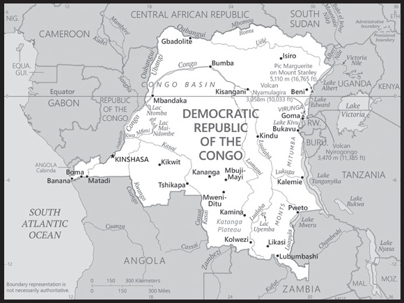
Location: Central Africa, northeast of Angola
Geographic coordinates: 0 00 N, 25 00 E
Map references: Africa
Area: total: 2,344,858 sq km
land: 2,267,048 sq km
water: 77,810 sq km
comparison ranking: total 12
Area - comparative: slightly less than one-fourth the size of the US
Land boundaries: total: 11,027 km
border countries (9): Angola 2,646 km (of which 225 km is the boundary of Angola’s discontiguous Cabinda Province); Burundi 236 km; Central African Republic 1,747 km; Republic of the Congo 1,775 km; Rwanda 221 km; South Sudan 714 km; Tanzania 479 km; Uganda 877 km; Zambia 2,332 km
Coastline: 37 km
Maritime claims: territorial sea: 12 nm
exclusive economic zone: since 2011, the DRC has had a Common Interest Zone agreement with Angola for the mutual development of off-shore resources
Climate: tropical; hot and humid in equatorial river basin; cooler and drier in southern highlands; cooler and wetter in eastern highlands; north of Equator - wet season (April to October), dry season (December to February); south of Equator - wet season (November to March), dry season (April to October)
Terrain: vast central basin is a low-lying plateau; mountains in east
Elevation: highest point: Pic Marguerite on Mont Ngaliema (Mount Stanley) 5,110 m
lowest point: Atlantic Ocean 0 m
mean elevation: 726 m
Natural resources: cobalt, copper, niobium, tantalum, petroleum, industrial and gem diamonds, gold, silver, zinc, manganese, tin, uranium, coal, hydropower, timber
note 1: coltan, the industrial name for a columbite–tantalite mineral from which niobium and tantalum are extracted, is being linked to warfare in the Democratic Republic of the Congo; mining of coltan is mainly artisanal and small-scale and vulnerable to extortion and human trafficking; fighting over cassiterite deposits, a tin ore, is also a major cause of conflict in eastern parts of the Democratic Republic of the Congo; tantalum, tin, tungsten, and gold extracted from central Africa are considered “conflict minerals” and as such are subject to international monitoring
note 2: the DROC is the World’s leading producer of cobalt, accounting for as much as 70% of the World’s supply; between 20-30% of this cobalt is produced in artisanal and small-scale mining operations which are vulnerable to extortion, human trafficking, and exploitative working conditions including child labor
Columbite-Tantalite:: Cobaltite:
Cassiterite:: Land use
agricultural land: 11.4% (2018 est.)
arable land: 3.1% (2018 est.)
permanent crops: 0.3% (2018 est.)
permanent pasture: 8% (2018 est.)
forest: 67.9% (2018 est.)
other: 20.7% (2018 est.)
Irrigated land: 110 sq km (2012)
Major lakes (area sq km): fresh water lake(s): Lake Tanganyika (shared with Burundi, Tanzania, and Zambia) - 32,000 sq km; Lake Albert (shared with Uganda) - 5,590 sq km; Lake Mweru (shared with Zambia) - 4,350 sq km; Lac Mai-Ndombe - 2,300 sq km; Lake Kivu (shared with Rwanda) - 2,220 sq km; Lake Edward (shared with Uganda) - 2,150 sq km; Lac Tumba - 500 sq km; Lac Upemba - 530 sq km
Major rivers (by length in km): Zaïre (Congo) river mouth (shared with Zambia [s], Angola, and Republic of Congo) - 4,700 km; Ubangi river mouth (shared with Central African Republic [s] and Republic of Congo) - 2,270 km note – [s] after country name indicates river source; [m] after country name indicates river mouth
Major watersheds (area sq km): Atlantic Ocean drainage: Congo (3,730,881 sq km), (Mediterranean Sea) Nile (3,254,853 sq km)
Indian Ocean drainage: Zambezi (1,332,412 sq km)
Major aquifers: Congo Basin
Population distribution: urban clusters are spread throughout the country, particularly in the northeast along the border with Uganda, Rwanda, and Burundi; the largest city is the capital, Kinshasha, located in the west along the Congo River; the south is least densely populated as shown in this population distribution map
Natural hazards: periodic droughts in south; Congo River floods (seasonal); active volcanoes in the east along the Great Rift Valley
volcanism: Nyiragongo (3,470 m), which erupted in 2002 and is experiencing ongoing activity, poses a major threat to the city of Goma, home to a quarter million people; the volcano produces unusually fast-moving lava, known to travel up to 100 km /hr; Nyiragongo has been deemed a Decade Volcano by the International Association of Volcanology and Chemistry of the Earth’s Interior, worthy of study due to its explosive history and close proximity to human populations; its neighbor, Nyamuragira, which erupted in 2010, is Africa’s most active volcano; Visoke is the only other historically active volcano
Geography - note: note 1: second largest country in Africa (after Algeria) and largest country in Sub-Saharan Africa; straddles the equator; dense tropical rain forest in central river basin and eastern highlands; the narrow strip of land that controls the lower Congo River is the DRC’s only outlet to the South Atlantic Ocean
note 2: because of its speed, cataracts, rapids, and turbulence the Congo River, most of which flows through the DRC, has never been accurately measured along much of its length; nonetheless, it is conceded to be the deepest river in the world; estimates of its greatest depth vary between 220 and 250 meters
PEOPLE AND SOCIETY
Population: 111,859,928 (2023 est.)
comparison ranking: 14
Nationality: noun: Congolese (singular and plural)
adjective: Congolese or Congo
Ethnic groups: more than 200 African ethnic groups of which the majority are Bantu; the four largest groups - Mongo, Luba, Kongo (all Bantu), and the Mangbetu-Azande (Hamitic) - make up about 45% of the population
Languages: French (official), Lingala (a lingua franca trade language), Kingwana (a dialect of Kiswahili or Swahili), Kikongo, Tshiluba
major-language sample(s):
Buku oyo ya bosembo ya Mokili Mobimba Ezali na Makanisi ya Liboso Mpenza. (Lingala)
Religions: Roman Catholic 29.9%, Protestant 26.7%, other Christian 36.5%, Kimbanguist 2.8%, Muslim 1.3%, other (includes syncretic sects and indigenous beliefs) 1.2%, none 1.3%, unspecified 0.2% (2014 est.)
Demographic profile: Despite a wealth of fertile soil, hydroelectric power potential, and mineral resources, the Democratic Republic of the Congo (DRC) struggles with many socioeconomic problems, including high infant and maternal mortality rates, malnutrition, poor vaccination coverage, lack of access to improved water sources and sanitation, and frequent and early fertility. Ongoing conflict, mismanagement of resources, and a lack of investment have resulted in food insecurity; almost 25% of children under the age of 5 were malnourished as of 2018. The overall coverage of basic public services – education, health, sanitation, and potable water – is very limited and piecemeal, with substantial regional and rural/urban disparities. Fertility remains high at more than 5 children per woman and is likely to remain high because of the low use of contraception and the cultural preference for larger families.
The DRC is a source and host country for refugees. Between 2012 and 2014, more than 119,000 Congolese refugees returned from the Republic of Congo to the relative stability of northwest DRC, but more than 1 million Congolese refugees and asylum seekers were hosted by neighboring countries as of December 2022. In addition, an estimated 5.5 million Congolese were internally displaced as of October 2022, the vast majority fleeing violence between rebel group and Congolese armed forces. Thousands of refugees have come to the DRC from neighboring countries, including Rwanda, the Central African Republic, South Sudan, and Burundi.
Age structure: 0-14 years: 45.99% (male 25,902,046/female 25,543,395)
15-64 years: 51.52% (male 28,798,920/female 28,835,212)
65 years and over: 2.49% (2023 est.) (male 1,211,966/female 1,568,389)
Dependency ratios: total dependency ratio: 98
youth dependency ratio: 92.1
elderly dependency ratio: 5.9
potential support ratio: 17.1 (2021 est.)
Median age: total: 16.7 years (2020)
male: 16.5 years
female: 16.8 years
comparison ranking: total 222
Population growth rate: 3.13% (2023 est.)
comparison ranking: 9
Birth rate: 39.64 births/1,000 population (2023 est.)
comparison ranking: 7
Death rate: 7.74 deaths/1,000 population (2023 est.)
comparison ranking: 100
Net migration rate: -0.63 migrant(s)/1,000 population (2023 est.)
comparison ranking: 130
Population distribution: urban clusters are spread throughout the country, particularly in the northeast along the border with Uganda, Rwanda, and Burundi; the largest city is the capital, Kinshasha, located in the west along the Congo River; the south is least densely populated as shown in this population distribution map
Urbanization: urban population: 47.4% of total population (2023)
rate of urbanization: 4.33% annual rate of change (2020-25 est.)
Major urban areas - population: 16.316 million KINSHASA (capital), 2.892 million Mbuji-Mayi, 2.812 million Lubumbashi, 1.664 million Kananga, 1.423 million Kisangani, 1.249 million Bukavu (2023)
Sex ratio: at birth: 1.03 male(s)/female
0-14 years: 1.01 male(s)/female
15-64 years: 1 male(s)/female
65 years and over: 0.77 male(s)/female
total population: 1 male(s)/female (2023 est.)
Mother’s mean age at first birth: 19.9 years (2013/14 est.)
note: data represents median age at first birth among women 20-49
Maternal mortality ratio: 547 deaths/100,000 live births (2020 est.)
comparison ranking: 11
Infant mortality rate: total: 59.12 deaths/1,000 live births (2023 est.)
male: 64.65 deaths/1,000 live births
female: 53.42 deaths/1,000 live births
comparison ranking: total 10
Life expectancy at birth: total population: 62.23 years (2023 est.)
male: 60.39 years
female: 64.13 years
comparison ranking: total population 216
Total fertility rate: 5.56 children born/woman (2023 est.)
comparison ranking: 3
Gross reproduction rate: 2.74 (2023 est.)
Contraceptive prevalence rate: 28.1% (2017/18)
Drinking water source: improved: urban: 88.8% of population
rural: 34.7% of population
total: 59.4% of population
unimproved: urban: 11.2% of population
rural: 65.3% of population
total: 40.6% of population (2020 est.)
Current health expenditure: 4.1% of GDP (2020)
Physicians density: 0.38 physicians/1,000 population (2018)
Sanitation facility access: improved: urban: 53.4% of population
rural: 20.5% of population
total: 35.5% of population
unimproved: urban: 46.6% of population
rural: 79.5% of population
total: 64.5% of population (2020 est.)
Major infectious diseases: degree of risk: very high (2023)
food or waterborne diseases: bacterial and protozoal diarrhea, hepatitis A, and typhoid fever
vectorborne diseases: malaria, dengue fever, and trypanosomiasis-gambiense (African sleeping sickness)
water contact diseases: schistosomiasis
animal contact diseases: rabies
note: on 31 August 2023, the US Centers for Disease Control and Prevention (CDC) issued a Travel Alert for polio in Africa; the Democratic Republic of the Congo is currently considered a high risk to travelers for circulating vaccine-derived polioviruses (cVDPV); vaccine-derived poliovirus (VDPV) is a strain of the weakened poliovirus that was initially included in oral polio vaccine (OPV) and that has changed over time and behaves more like the wild or naturally occurring virus; this means it can be spread more easily to people who are unvaccinated against polio and who come in contact with the stool or respiratory secretions, such as from a sneeze, of an “infected” person who received oral polio vaccine; the CDC recommends that before any international travel, anyone unvaccinated, incompletely vaccinated, or with an unknown polio vaccination status should complete the routine polio vaccine series; before travel to any high-risk destination, the CDC recommends that adults who previously completed the full, routine polio vaccine series receive a single, lifetime booster dose of polio vaccine
Obesity - adult prevalence rate: 6.7% (2016)
comparison ranking: 164
Alcohol consumption per capita: total: 0.56 liters of pure alcohol (2019 est.)
beer: 0.5 liters of pure alcohol (2019 est.)
wine: 0.01 liters of pure alcohol (2019 est.)
spirits: 0.05 liters of pure alcohol (2019 est.)
other alcohols: 0 liters of pure alcohol (2019 est.)
comparison ranking: total 161
Tobacco use: total: 12.8% (2020 est.)
male: 22.7% (2020 est.)
female: 2.9% (2020 est.)
comparison ranking: total 118
Children under the age of 5 years underweight: 23.1% (2017/18)
comparison ranking: 7
Currently married women (ages 15-49): 55.3% (2023 est.)
Child marriage: women married by age 15: 8.4%
women married by age 18: 29.1%
men married by age 18: 5.6% (2018 est.)
Education expenditures: 2.7% of GDP (2021 est.)
comparison ranking: 171
Literacy: definition: age 15 and over can read and write French, Lingala, Kingwana, or Tshiluba
total population: 80%
male: 89.5%
female: 70.8% (2021)
School life expectancy (primary to tertiary education): total: 11 years
male: 10 years
female: 9 years (2013)
Youth unemployment rate (ages 15-24): total: 10.1% (2021 est.)
male: 12%
female: 8.5%
comparison ranking: total 152
ENVIRONMENT
Environment - current issues: poaching threatens wildlife populations; water pollution; deforestation (forests endangered by fires set to clear the land for agricultural purposes; forests also used as a source of fuel); soil erosion; mining (diamonds, gold, coltan - a mineral used in creating capacitors for electronic devices) causing environmental damage
Environment - international agreements: party to: Biodiversity, Climate Change, Climate Change-Kyoto Protocol, Climate Change-Paris Agreement, Comprehensive Nuclear Test Ban, Desertification, Endangered Species, Hazardous Wastes, Law of the Sea, Marine Dumping-London Convention, Nuclear Test Ban, Ozone Layer Protection, Tropical Timber 2006, Wetlands
signed, but not ratified: Environmental Modification
Climate: tropical; hot and humid in equatorial river basin; cooler and drier in southern highlands; cooler and wetter in eastern highlands; north of Equator - wet season (April to October), dry season (December to February); south of Equator - wet season (November to March), dry season (April to October)
Land use: agricultural land: 11.4% (2018 est.)
arable land: 3.1% (2018 est.)
permanent crops: 0.3% (2018 est.)
permanent pasture: 8% (2018 est.)
forest: 67.9% (2018 est.)
other: 20.7% (2018 est.)
Urbanization: urban population: 47.4% of total population (2023)
rate of urbanization: 4.33% annual rate of change (2020-25 est.)
Food insecurity: widespread lack of access: due to internal conflict in eastern regions and high food prices - according to an October 2022 analysis, 24.5 million people were projected to experience acute food insecurity between January and June 2023; this is due to the intensification of the conflict in the northeastern provinces, which, among other factors, has prevented completion of the harvests and likely will reduce food availability in the months to come (2023)
Revenue from forest resources: 8.72% of GDP (2018 est.)
comparison ranking: 6
Revenue from coal: 0% of GDP (2018 est.)
comparison ranking: 90
Air pollutants: particulate matter emissions: 31.58 micrograms per cubic meter (2019 est.)
carbon dioxide emissions: 2.02 megatons (2016 est.)
methane emissions: 61.24 megatons (2020 est.)
Waste and recycling: municipal solid waste generated annually: 14,385,226 tons (2016 est.)
municipal solid waste recycled annually: 704,876 tons (2005 est.)
percent of municipal solid waste recycled: 4.9% (2005 est.)
Major lakes (area sq km): fresh water lake(s): Lake Tanganyika (shared with Burundi, Tanzania, and Zambia) - 32,000 sq km; Lake Albert (shared with Uganda) - 5,590 sq km; Lake Mweru (shared with Zambia) - 4,350 sq km; Lac Mai-Ndombe - 2,300 sq km; Lake Kivu (shared with Rwanda) - 2,220 sq km; Lake Edward (shared with Uganda) - 2,150 sq km; Lac Tumba - 500 sq km; Lac Upemba - 530 sq km
Major rivers (by length in km): Zaïre (Congo) river mouth (shared with Zambia [s], Angola, and Republic of Congo) - 4,700 km; Ubangi river mouth (shared with Central African Republic [s] and Republic of Congo) - 2,270 km note – [s] after country name indicates river source; [m] after country name indicates river mouth
Major watersheds (area sq km): Atlantic Ocean drainage: Congo (3,730,881 sq km), (Mediterranean Sea) Nile (3,254,853 sq km)
Indian Ocean drainage: Zambezi (1,332,412 sq km)
Major aquifers: Congo Basin
Total water withdrawal: municipal: 460 million cubic meters (2020 est.)
industrial: 150 million cubic meters (2020 est.)
agricultural: 70 million cubic meters (2020 est.)
Total renewable water resources: 1.29 trillion cubic meters (2020 est.)
GOVERNMENT
Country name: conventional long form: Democratic Republic of the Congo
conventional short form: DRC
local long form: Republique Democratique du Congo
local short form: RDC
former: Congo Free State, Belgian Congo, Congo/Leopoldville, Congo/Kinshasa, Zaire
abbreviation: DRC (or DROC)
etymology: named for the Congo River, most of which lies within the DRC; the river name derives from Kongo, a Bantu kingdom that occupied its mouth and whose name stems from its people the Bakongo, meaning “hunters”
Government type: semi-presidential republic
Capital: name: Kinshasa
geographic coordinates: 4 19 S, 15 18 E
time difference: UTC+1 (6 hours ahead of Washington, DC, during Standard Time)
time zone note: the DRC has two time zones
etymology: founded as a trading post in 1881 and named Leopoldville in honor of King LEOPOLD II of the Belgians, who controlled the Congo Free State, the vast central African territory that became the Democratic Republic of the Congo in 1960; in 1966, Leopoldville was renamed Kinshasa, after a village of that name that once stood near the site
Administrative divisions: 26 provinces (provinces, singular - province); Bas-Uele (Lower Uele), Equateur, Haut-Katanga (Upper Katanga), Haut-Lomami (Upper Lomami), Haut-Uele (Upper Uele), Ituri, Kasai, Kasai-Central, Kasai-Oriental (East Kasai), Kinshasa, Kongo Central, Kwango, Kwilu, Lomami, Lualaba, Mai-Ndombe, Maniema, Mongala, Nord-Kivu (North Kivu), Nord-Ubangi (North Ubangi), Sankuru, Sud-Kivu (South Kivu), Sud-Ubangi (South Ubangi), Tanganyika, Tshopo, Tshuapa
Independence: 30 June 1960 (from Belgium)
National holiday: Independence Day, 30 June (1960)
Constitution: history: several previous; latest adopted 13 May 2005, approved by referendum 18-19 December 2005, promulgated 18 February 2006
amendments: proposed by the president of the republic, by the government, by either house of Parliament, or by public petition; agreement on the substance of a proposed bill requires absolute majority vote in both houses; passage requires a referendum only if both houses in joint meeting fail to achieve three-fifths majority vote; constitutional articles, including the form of government, universal suffrage, judicial independence, political pluralism, and personal freedoms, cannot be amended; amended 2011
Legal system: civil law system primarily based on Belgian law, but also customary and tribal law
International law organization participation: accepts compulsory ICJ jurisdiction with reservations; accepts ICCt jurisdiction
Citizenship: citizenship by birth: no
citizenship by descent only: at least one parent must be a citizen of the Democratic Republic of the Congo
dual citizenship recognized: no
residency requirement for naturalization: 5 years
Suffrage: 18 years of age; universal and compulsory
Executive branch: chief of state: President Felix TSHISEKEDI (since 24 January 2019)
head of government: Prime Minister Jean-Michel Sama LUKONDE (since 15 February 2021); Deputy Prime Ministers Jose MAKILA, Leonard She OKITUNDU, Henri MOVA Sankanyi (since February 2018) Jean-Pierre BEMBBA (since 23 March 2023)
cabinet: Ministers of State appointed by the president
elections/appointments: president directly elected by simple majority vote for a 5-year term (eligible for a second term); election last held on 30 December 2018 (next to be held on 20 December 2023); prime minister appointed by the president
election results:
2018: Felix TSHISEKEDI elected president; percent of vote - Felix TSHISEKEDI (UDPS) 38.6%, Martin FAYULU (Lamuka coalition) 34.8%, Emmanuel Ramazani SHADARY (PPRD) 23.9%, other 2.7%; note - election marred by serious voting irregularities
2011: Joseph KABILA reelected president; percent of vote - Joseph KABILA (PPRD) 49%, Etienne TSHISEKEDI (UDPS) 32.3%, other 18.7%; note - election marred by serious voting irregularities
Legislative branch: description: bicameral Parliament or Parlement consists of:
Senate (109 seats; 109 members to include 108 indirectly elected by provincial assemblies by proportional representation vote to serve 5-year terms and a former president, appointed for life)
National Assembly (500 seats; 439 members directly elected in multi-seat constituencies by proportional representation vote and 61 directly elected in single-seat constituencies by simple majority vote; members serve 5-year terms)
elections:
Senate - last held on 14 March 2019
National Assembly - last held on 30 December 2018 (first round), with a second round on 31 March 2019 (next election held 20 December 2023)
election results:
Senate - percent of vote by party - NA; seats by party - PPRD 22, MLC 14, FR 7, RCD 7, PDC 6, CDC 3, MSR 3, PALU 2, other 18, independent 26; composition as of 2022 - men 83, women 26, percent of women 23.9%
National Assembly - percent of vote by party - NA; seats by party - PPRD 62, UDPS 41, PPPD 29, MSR 27, MLC 22, PALU 19, UNC 17, ARC 16, AFDC 15, ECT 11, RRC 11, other 214 (includes numerous political parties that won 10 or fewer seats and 2 constituencies where voting was halted), independent 16; composition as of 2022 - men 436, women 64, percent of women 12.8%; total Parliament percent of women 14.8%
Judicial branch: highest court(s): Court of Cassation or Cour de Cassation (consists of 26 justices and organized into legislative and judiciary sections); Constitutional Court (consists of 9 judges)
judge selection and term of office: Court of Cassation judges nominated by the Judicial Service Council, an independent body of public prosecutors and selected judges of the lower courts; judge tenure NA; Constitutional Court judges - 3 nominated by the president, 3 by the Judicial Service Council, and 3 by the legislature; judges appointed by the president to serve 9-year non-renewable terms with one-third of the membership renewed every 3 years
subordinate courts: State Security Court; Court of Appeals (organized into administrative and judiciary sections); Tribunal de Grande; magistrates’ courts; customary courts
Political parties and leaders: Christian Democrat Party or PDC [Jose ENDUNDO]
Congolese Rally for Democracy or RCD [Azarias RUBERWA]
Convention of Christian Democrats or CDC [NA]
Engagement for Citizenship and Development or ECiDe [Martin FAYULU]
Forces of Renewal or FR [Mbusa NYAMWISI]
Lamuka coalition [Martin FAYULU] (includes ECiDe, MLC, Together for Change, CNB, and Nouvel Elan)
Movement for the Liberation of the Congo or MLC [Jean-Pierre BEMBA]
Nouvel Elan [Adolphe MUZITO]
Our Congo or CNB (“Congo Na Biso”) [Freddy MATUNGULU]
People’s Party for Reconstruction and Democracy or PPRD [Henri MOVA Sakanyi]
Social Movement for Renewal or MSR [Pierre LUMBI]
Together for Change (“Ensemble”) [Moise KATUMBI]
Unified Lumumbist Party or PALU [NA]
Union for the Congolese Nation or UNC [Vital KAMERHE]
Union for Democracy and Social Progress or UDPS [Felix TSHISEKEDI]
International organization participation: ACP, AfDB, AU, CEMAC, CEPGL, COMESA, EITI (compliant country), FAO, G-24, G-77, IAEA, IBRD, ICAO, ICC (NGOs), ICCt, ICRM, IDA, IFAD, IFC, IFRCS, IHO, ILO, IMF, IMO, Interpol, IOC, IOM, IPU, ISO, ITSO, ITU, ITUC (NGOs), LCBC (observer), MIGA, NAM, OIF, OPCW, PCA, SADC, UN, UNCTAD, UNESCO, UNHCR, UNIDO, UNWTO, UPU, WCO, WFTU (NGOs), WHO, WIPO, WMO, WTO
Diplomatic representation in the US: chief of mission: Ambassador Marie-Hélène Mathey Boo LOWUMBA (since 7 June 2022)
chancery: 1100 Connecticut Avenue NW, Suite 725, Washington DC 20036
telephone: [1] (202) 234-7690
FAX: [1] (202) 234-2609
email address and website:
representative office: New York
Diplomatic representation from the US: chief of mission: Ambassador Lucy TAMLYN (since 6 February 2023)
embassy: 310 Avenue des Aviateurs, Kinshasa, Gombe
mailing address: 2220 Kinshasa Place, Washington DC 20521-2220
telephone: [243] 081 556-0151
FAX: [243] 81 556-0175
email address and website:
Flag description: sky blue field divided diagonally from the lower hoist corner to upper fly corner by a red stripe bordered by two narrow yellow stripes; a yellow, five-pointed star appears in the upper hoist corner; blue represents peace and hope, red the blood of the country’s martyrs, and yellow the country’s wealth and prosperity; the star symbolizes unity and the brilliant future for the country
National symbol(s): leopard; national colors: sky blue, red, yellow
National anthem: name: “Debout Congolaise” (Arise Congolese)
lyrics/music: Joseph LUTUMBA/Simon-Pierre BOKA di Mpasi Londi
note: adopted 1960; replaced when the country was known as Zaire; but readopted in 1997
National heritage: total World Heritage Sites: 5 (all natural)
selected World Heritage Site locales: Garamba National Park; Kahuzi-Biega National Park; Okapi Wildlife Reserve; Salonga National Park; Virunga National Park
ECONOMY
Economic overview: very poor, large, natural resource-rich sub-Saharan country; possesses the world’s second largest rainforest; increasing Chinese extractive sector trade; massive decrease in government investments; increasing current account deficit and public debts
Real GDP (purchasing power parity): $102.956 billion (2021 est.)
$96.945 billion (2020 est.)
$95.292 billion (2019 est.)
note: data are in 2017 dollars
comparison ranking: 91
Real GDP growth rate: 6.2% (2021 est.)
1.74% (2020 est.)
4.38% (2019 est.)
comparison ranking: 70
Real GDP per capita: $1,100 (2021 est.)
$1,000 (2020 est.)
$1,100 (2019 est.)
note: data are in 2017 dollars
comparison ranking: 226
GDP (official exchange rate)
$47.16 billion (2019 est.)
Inflation rate (consumer prices): 41.5% (2017 est.)
18.2% (2016 est.)
comparison ranking: 7
Credit ratings: Moody’s rating: Caa1 (2019)
Standard & Poors rating: CCC+ (2017)
note: The year refers to the year in which the current credit rating was first obtained.
GDP - composition, by sector of origin
agriculture: 19.7% (2017 est.)
industry: 43.6% (2017 est.)
services: 36.7% (2017 est.)
comparison rankings: services 218; industry 21; agriculture 51
GDP - composition, by end use
household consumption: 78.5% (2017 est.)
government consumption: 12.7% (2017 est.)
investment in fixed capital: 15.9% (2017 est.)
investment in inventories: 0% (2017 est.)
exports of goods and services: 25.7% (2017 est.)
imports of goods and services: -32.8% (2017 est.)
Agricultural products: cassava, plantains, sugar cane, maize, oil palm fruit, rice, roots/tubers nes, bananas, sweet potatoes, groundnuts
Industries: mining (copper, cobalt, gold, diamonds, coltan, zinc, tin, tungsten), mineral processing, consumer products (textiles, plastics, footwear, cigarettes), metal products, processed foods and beverages, timber, cement, commercial ship repair
Industrial production growth rate: 7.78% (2021 est.)
comparison ranking: 54
Labor force: 33.382 million (2021 est.)
comparison ranking: 18
Unemployment rate: 5.43% (2021 est.)
5.27% (2020 est.)
4.45% (2019 est.)
comparison ranking: 135
Youth unemployment rate (ages 15-24): total: 10.1% (2021 est.)
male: 12%
female: 8.5%
comparison ranking: total 152
Population below poverty line: 63% (2014 est.)
Gini Index coefficient - distribution of family income: 42.1 (2012 est.)
comparison ranking: 42
Household income or consumption by percentage share: lowest 10%: 2.3%
highest 10%: 34.7% (2006)
Budget: revenues: $5.419 billion (2019 est.)
expenditures: $6.382 billion (2019 est.)
Budget surplus (+) or deficit (-): -0.9% (of GDP) (2017 est.)
comparison ranking: 73
Public debt: 18.1% of GDP (2017 est.)
19.3% of GDP (2016 est.)
comparison ranking: 194
Taxes and other revenues: 11.2% (of GDP) (2017 est.)
comparison ranking: 185
Fiscal year: calendar year
Current account balance: -$587.407 million (2021 est.)
-$1.052 billion (2020 est.)
-$1.693 billion (2019 est.)
comparison ranking: 122
Exports: $22.354 billion (2021 est.)
$13.932 billion (2020 est.)
$15.173 billion (2019 est.)
note: Data are in current year dollars and do not include illicit exports or re-exports.
comparison ranking: 83
Exports - partners: China 53%, United Arab Emirates 11%, Saudi Arabia 6%, South Korea 5% (2019)
Exports - commodities: copper, cobalt, crude petroleum, tin, diamonds (2021)
Imports: $22.193 billion (2021 est.) note: data are in current year dollars
$14.557 billion (2020 est.) note: data are in current year dollars
$16.892 billion (2019 est.) note: data are in current year dollars
comparison ranking: 88
Imports - partners: China 29%, South Africa 15%, Zambia 12%, Rwanda 5%, Belgium 5%, India 5% (2019)
Imports - commodities: packaged medicines, refined petroleum, sulfuric acid, stone processing machines, delivery trucks (2019)
Reserves of foreign exchange and gold: $3.467 billion (31 December 2021 est.)
$747.655 million (31 December 2020 est.)
$1.194 billion (31 December 2019 est.)
comparison ranking: 112
Debt - external: $4.963 billion (31 December 2017 est.)
$5.35 billion (31 December 2016 est.)
comparison ranking: 134
Exchange rates: Congolese francs (CDF) per US dollar -
Exchange rates:: 1,989.391 (2021 est.)
1,851.122 (2020 est.)
1,647.76 (2019 est.)
1,622.524 (2018 est.)
1,464.418 (2017 est.)
ENERGY
Electricity access: population without electricity: 82 million (2020)
electrification - total population: 20.7% (2021)
electrification - urban areas: 43.7% (2021)
electrification - rural areas: 1% (2021)
Electricity: installed generating capacity: 2.919 million kW (2020 est.)
consumption: 7,181,700,000 kWh (2019 est.)
exports: 248 million kWh (2019 est.)
imports: 385 million kWh (2019 est.)
transmission/distribution losses: 2.142 billion kWh (2019 est.)
comparison rankings: installed generating capacity 110; transmission/distribution losses 87; imports 93; exports 87; consumption 110
Electricity generation sources: fossil fuels: 0.1% of total installed capacity (2020 est.)
solar: 0.1% of total installed capacity (2020 est.)
hydroelectricity: 99.6% of total installed capacity (2020 est.)
biomass and waste: 0.3% of total installed capacity (2020 est.)
Coal: production: 0 metric tons (2020 est.)
consumption: 10,000 metric tons (2020 est.)
exports: 0 metric tons (2020 est.)
imports: 10,000 metric tons (2020 est.)
proven reserves: 88 million metric tons (2019 est.)
Petroleum: total petroleum production: 22,000 bbl/day (2021 est.)
refined petroleum consumption: 17,900 bbl/day (2019 est.)
crude oil and lease condensate exports: 21,300 bbl/day (2018 est.)
crude oil and lease condensate imports: 0 bbl/day (2018 est.)
crude oil estimated reserves: 180 million barrels (2021 est.)
Refined petroleum products - production: 0 bbl/day (2017 est.)
comparison ranking: 127
Refined petroleum products - exports: 0 bbl/day (2015 est.)
comparison ranking: 130
Refined petroleum products - imports: 21,140 bbl/day (2015 est.)
comparison ranking: 115
Natural gas: production: 368,000 cubic meters (2019 est.)
consumption: 368,000 cubic meters (2019 est.)
exports: 0 cubic meters (2021 est.)
imports: 0 cubic meters (2021 est.)
proven reserves: 991 million cubic meters (2021 est.)
Carbon dioxide emissions: 2.653 million metric tonnes of CO2 (2019 est.)
from coal and metallurgical coke: 44,000 metric tonnes of CO2 (2019 est.)
from petroleum and other liquids: 2.608 million metric tonnes of CO2 (2019 est.)
from consumed natural gas: 1,000 metric tonnes of CO2 (2019 est.)
comparison ranking: total emissions 151
Energy consumption per capita: 1.371 million Btu/person (2019 est.)
comparison ranking: 192
COMMUNICATIONS
Telephones - fixed lines: total subscriptions: (2021 est.) less than 1
subscriptions per 100 inhabitants: (2021 est.) less than 1
Telephones - mobile cellular: total subscriptions: 47 million (2021 est.)
subscriptions per 100 inhabitants: 49 (2021 est.)
comparison ranking: total subscriptions 36
Telecommunication systems: general assessment: the telecom system remains one of the least developed in the region; the government can only loosely regulate the sector; the investment made in infrastructure is derived from donor countries or from the efforts of foreign (particularly Chinese) companies and banks; efforts have been made to improve the regulation of the telecom sector; the limited fixed-line infrastructure has become the principal providers of basic telecom services; the development of the DRC’s internet and broadband market has been held back by the poorly developed national and international infrastructure; the country was finally connected to international bandwidth through the WACS submarine cable in 2013; breakages in the WACS cable have exposed the vulnerability of international bandwidth, which is still limited; the Equiano submarine cable, and has also completed a 5,000km cable running through the DRC to link to cable systems landing in countries facing the Atlantic and Indian Oceans; the first commercial LTE networks were launched in May 2018 soon after LTE licenses were issued; mobile operators are keen to develop mobile data services, capitalizing on the growth of smartphones usage; there has been some progress with updating technologies, most of the GSM network has been upgraded to 3G by 2021 (2022)
domestic: inadequate fixed-line infrastructure with fixed-line connections less than 1 per 100 persons; mobile-cellular subscriptions over 49 per 100 persons (2021)
international: country code - 243; ACE and WACS submarine cables to West and South Africa and Europe; satellite earth station - 1 Intelsat (Atlantic Ocean) (2019)
Broadcast media: state-owned TV broadcast station with near national coverage; more than a dozen privately owned TV stations - 2 with near national coverage; 2 state-owned radio stations are supplemented by more than 100 private radio stations; transmissions of at least 2 international broadcasters are available
Internet country code: .cd
Internet users: total: 21,102,720 (2021 est.)
percent of population: 23.2% (2021 est.)
comparison ranking: total 41
Broadband - fixed subscriptions: total: 31,000 (2020 est.)
subscriptions per 100 inhabitants: 0.03 (2020 est.)
comparison ranking: total 153
TRANSPORTATION
National air transport system: number of registered air carriers: 8 (2020)
inventory of registered aircraft operated by air carriers: 13
annual passenger traffic on registered air carriers: 932,043 (2018)
annual freight traffic on registered air carriers: 890,000 (2018) mt-km
Civil aircraft registration country code prefix: 9Q
Airports: 198 (2021)
comparison ranking: total 28
Airports - with paved runways: 26
note: paved runways have a concrete or asphalt surface but not all have facilities for refueling, maintenance, or air traffic control; the length of a runway required for aircraft to safely operate depends on a number of factors including the type of aircraft, the takeoff weight (including passengers, cargo, and fuel), engine types, flap settings, landing speed, elevation of the airport, and average maximum daily air temperature; paved runways can reach a length of 5,000 m (16,000 ft.), but the “typical” length of a commercial airline runway is between 2,500-4,000 m (8,000-13,000 ft.)
Airports - with unpaved runways: 172
note: unpaved runways have a surface composition such as grass or packed earth and are most suited to the operation of light aircraft; unpaved runways are usually short, often less than 1,000 m (3,280 ft.) in length; airports with unpaved runways often lack facilities for refueling, maintenance, or air traffic control
Heliports: 1 (2021)
Pipelines: 62 km gas, 77 km oil, 756 km refined products (2013)
Railways: total: 4,007 km (2014)
narrow gauge: 3,882 km (2014) 1.067-m gauge (858 km electrified)
125 1.000-mm gauge
comparison ranking: total 47
Roadways: total: 152,373 km (2015)
paved: 3,047 km (2015)
unpaved: 149,326 km (2015)
urban: 7,400 km (2015)
non-urban: 144,973 km
comparison ranking: total 34
Waterways: 15,000 km (2011) (including the Congo River, its tributaries, and unconnected lakes)
comparison ranking: 9
Merchant marine: total: 23 (2022)
by type: general cargo 5, oil tanker 2, other 16
comparison ranking: total 144
Ports and terminals: major seaport(s): Banana
river or lake port(s): Boma, Bumba, Kinshasa, Kisangani, Matadi, Mbandaka (Congo); Kindu (Lualaba); Bukavu, Goma (Lake Kivu); Kalemie (Lake Tanganyika)
MILITARY AND SECURITY
Military and security forces: Armed Forces of the Democratic Republic of the Congo (Forces d’Armees de la Republique Democratique du Congo, FARDC): Land Forces, National Navy (La Marine Nationale), Congolese Air Force (Force Aerienne Congolaise, FAC); Republican Guard (2023)
note 1: the Congolese National Police are under the Ministry of Interior
note 2: the Republican Guard is a division-size element consisting of approximately 5 regiments; it is regarded as the country’s best equipped and trained military unit and is under the direct control of the president
Military expenditures: 0.6% of GDP (2022 est.)
0.7% of GDP (2021 est.)
0.7% of GDP (2020 est.)
0.9% of GDP (2019 est.)
0.8% of GDP (2018 est.)
comparison ranking: 154
Military and security service personnel strengths: estimates vary; up to 140,000 active troops, including approximately 10,000 Republican Guard (2023)
Military equipment inventories and acquisitions: the FARDC is equipped mostly with Soviet-era weapons systems and equipment (2023)
Military service age and obligation: 18-45 years of age for voluntary military service for men and women; 18-45 years of age for compulsory military service for men; it is unclear how much conscription is used (2023)
note: in eastern Congo, fighters from armed groups, and in some cases government security forces, have been accused of forced recruitment of child soldiers
Military - note: the FARDC’s primary focus is internal security; while the FARDC is large on paper, with an estimated 18 operational infantry brigades, it struggles to provide security in large portions of the country; the FARDC is widely assessed to suffer from insufficient training, low equipment readiness, poor morale and leadership, ill-discipline, and widespread corruption; it was created out of the armed factions of the Congo wars that ended in 2003, incorporating various militia, paramilitary, and rebel formations; the DRC’s most effective military force, the Republican Guard, is overseen by the office of the presidency rather than the FARDC and focuses largely on protecting the president and government institutions and enforcing internal security
the FARDC is actively conducting operations against a variety of illegal armed groups (IOGs) operating in the DRC, particularly in the eastern provinces of Ituri, North Kivu, and South Kivu, where more than 15 significant and cohesive IOGs operate; there is also violence in Maniema, Kasai, Kasai Central, and Tanganyika provinces; some estimates place over 100 IOGs operating in the country, including organized militias, such as the Nduma Defense of Congo-Renewal (NDC-R), which controls a large portion of North Kivu; Mai Mai groups (local militias that operate variously as self-defense networks and criminal rackets); and foreign-origin groups seeking safe haven and resources, such as the Ugandan-origin Allied Democratic Forces (ADF; aka Islamic State of Iraq and ash-Sham in the DRC), the Democratic Forces for the Liberation of Rwanda (FDLR), multiple groups originating from Burundi, the Lords Resistance Army (LRA), and the March 23 Movement (aka M23 or Congolese Revolutionary Army), which the DRC has accused Rwanda of backing; the FARDC has been accused of collaborating with some IOGs, such as the NDC-R; in 2023, the East Africa Community deployed a regional force to oversee the withdrawal of the M23 rebel group from the country; countries sending troops included Burundi, Kenya, Uganda, and South Sudan
the United Nations Organization Stabilization Mission in the Democratic Republic of the Congo (MONUSCO) has operated in the central and eastern parts of the country since 1999; as of 2023, MONUSCO had over 14,000 personnel assigned, but it was drawing down its forces towards a complete withdrawal at the request of the DRC Government; MONUSCO includes a Force Intervention Brigade (FIB; three infantry battalions, plus artillery and special forces), the first ever UN peacekeeping force specifically tasked to carry out targeted offensive operations to neutralize and disarm groups considered a threat to state authority and civilian security (2023)
TERRORISM
Terrorist group(s): Terrorist group(s): Islamic State of Iraq and ash-Sham – Democratic Republic of the Congo (ISIS-DRC)
note: details about the history, aims, leadership, organization, areas of operation, tactics, targets, weapons, size, and sources of support of the group(s) appear(s) in Appendix-T
TRANSNATIONAL ISSUES
Disputes - international: heads of the Great Lakes states and UN pledged in 2004 to abate tribal, rebel, and militia fighting in the region, including northeast Congo
Democratic Republic of Congo (DRC)-Republic of the Congo: the location of the boundary in the broad Congo River is indefinite except in the Pool Malebo/Stanley Pool area
Democratic Republic of Congo (DRC)-Uganda: Uganda rejects the DRC claim to Margherita Peak in the Rwenzori mountains and considers it a boundary divide; there is tension and violence on Lake Albert over prospective oil reserves at the mouth of the Semliki River; the Ugandan-origin Allied Democratic Forces (ADF; aka Islamic State of Iraq and ash-Sham in the DRC) operates on both sides of the border
Democratic Republic of Congo (DRC)-Zambia: boundary commission continues discussions over Congolese-administered triangle of land on the right bank of the Lunkinda River claimed by Zambia near the DRC village of Pweto
Democratic Republic of Congo (DRC)-Angola: DRC has accused Angola of shifting monuments
Democratic Republic of Congo (DRC)-Rwanda: the DRC has accused Rwanda of backing the armed separatist group March 23 Movement (aka M23 or Congolese Revolutionary Army)
Democratic Republic of Congo (DRC)-Burundi: multiple armed groups originating from Burundi operate in the DRC
Refugees and internally displaced persons: refugees (country of origin): 211,963 (Central African Republic), 208,328 (Rwanda), 53,194 (South Sudan) (refugees and asylum seekers), 46,272 (Burundi) (2023)
IDPs: 6.38 million (fighting between government forces and rebels since mid-1990s; conflict in Kasai region since 2016) (2023)
Illicit drugs: country of origin of methamphetamine destined for overseas markets;
INTRODUCTION
Background: Upon independence in 1960, the former French region of Middle Congo became the Republic of the Congo. A quarter century of experimentation with Marxism was abandoned in 1990 and a democratically elected government took office in 1992. A two-year civil war that ended in 1999 restored former Marxist President Denis SASSOU-Nguesso, who had ruled from 1979 to 1992, and sparked a short period of ethnic and political unrest that was resolved by a peace agreement in late 1999. A new constitution adopted three years later provided for a multi-party system and a seven-year presidential term, and elections arranged shortly thereafter retained SASSOU-Nguesso. Following a year of renewed fighting, President SASSOU-Nguesso and southern-based rebel groups agreed to a final peace accord in March 2003. SASSOU-Nguesso was reelected in 2009 and, after passing a referendum allowing him to run for additional terms, was reelected again in 2016 and 2021. The Republic of Congo is one of Africa’s largest petroleum producers, but with declining production it will need new offshore oil finds to sustain its oil earnings over the long term.
GEOGRAPHY
Location: Central Africa, bordering the South Atlantic Ocean, between Angola and Gabon
Geographic coordinates: 1 00 S, 15 00 E
Map references: Africa
Area: total: 342,000 sq km
land: 341,500 sq km
water: 500 sq km
comparison ranking: total 65
Area - comparative: slightly smaller than Montana; about twice the size of Florida
Land boundaries: total: 5,554 km
border countries (5): Angola 231 km; Cameroon 494 km; Central African Republic 487 km; Democratic Republic of the Congo 1,775 km; Gabon 2,567 km
Coastline: 169 km
Maritime claims: territorial sea: 12 nm
contiguous zone: 24 nm
exclusive economic zone: 200 nm
Climate: tropical; rainy season (March to June); dry season (June to October); persistent high temperatures and humidity; particularly enervating climate astride the Equator
Terrain: coastal plain, southern basin, central plateau, northern basin
Elevation: highest point: Mont Nabeba 1,020 m
lowest point: Atlantic Ocean 0 m
mean elevation: 430 m
Natural resources: petroleum, timber, potash, lead, zinc, uranium, copper, phosphates, gold, magnesium, natural gas, hydropower
Land use: agricultural land: 31.1% (2018 est.)
arable land: 1.6% (2018 est.)
permanent crops: 0.2% (2018 est.)
permanent pasture: 29.3% (2018 est.)
forest: 65.6% (2018 est.)
other: 3.3% (2018 est.)
Irrigated land: 20 sq km (2012)
Major rivers (by length in km): Oubangui (Ubangi) (shared with Central African Republic [s] and Democratic Republic of Congo [m]) - 2,270 km
note – [s] after country name indicates river source; [m] after country name indicates river mouth
Major watersheds (area sq km): Atlantic Ocean drainage: Congo (3,730,881 sq km)
Major aquifers: Congo Basin
Population distribution: the population is primarily located in the south, in and around the capital of Brazzaville as shown in this population distribution map
Natural hazards: seasonal flooding
Geography - note: about 70% of the population lives in Brazzaville, Pointe-Noire, or along the railroad between them
PEOPLE AND SOCIETY
Population: 5,677,493 (2023 est.)
comparison ranking: 116
Nationality: noun: Congolese (singular and plural)
adjective: Congolese or Congo
Ethnic groups: Kongo (Bakongo) 40.5%, Teke 16.9%, Mbochi 13.1%, foreigner 8.2%, Sangha 5.6%, Mbere/Mbeti/Kele 4.4%, Punu 4.3%, Pygmy 1.6%, Oubanguiens 1.6%, Duma 1.5%, Makaa 1.3%, other and unspecified 1% (2014-15 est.)
Languages: French (official), French Lingala and Monokutuba (lingua franca trade languages), many local languages and dialects (of which Kikongo is the most widespread)
major-language sample(s):
Buku oyo ya bosembo ya Mokili Mobimba Ezali na Makanisi ya Liboso Mpenza. (Lingala)
Religions: Roman Catholic 33.1%, Awakening Churches/Christian Revival 22.3%, Protestant 19.9%, Salutiste 2.2%, Muslim 1.6%, Kimbanguiste 1.5%, other 8.1%, none 11.3% (2007 est.)
Demographic profile: The Republic of the Congo is one of the most urbanized countries in Africa, with nearly 70% of Congolese living in urban areas. The population is concentrated in the southwest of the country, mainly in the capital Brazzaville, Pointe-Noire, and along the railway line that connects the two. The tropical jungles in the north of the country are sparsely populated. Most Congolese are Bantu, and most belong to one of four main ethnic groups, the Kongo, Teke, Mbochi, and Sangha, which consist of over 70 subgroups.
The Republic of Congo is in the early stages of a demographic transition, whereby a population shifts from high fertility and mortality rates to low fertility and mortality rates associated with industrialized societies. Its total fertility rate (TFR), the average number of children born per woman, remains high at 4.4 as of 2022. While its TFR has steadily decreased, the progress slowed beginning in about 1995. The slowdown in fertility reduction has delayed the demographic transition and Congo’s potential to reap a demographic dividend, the economic boost that can occur when the share of the working-age population is larger than the dependent age groups.
The TFR differs significantly between urban and rural areas – 3.7 in urban areas versus 6.5 in rural areas. The TFR also varies among regions. The urban regions of Brazzaville and Pointe-Noire have much lower TFRs than other regions, which are predominantly or completely rural. The gap between desired fertility and actual fertility is also greatest in rural areas. Rural families may have more children to contribute to agricultural production and/or due to a lack of information about and access to contraception. Urban families may prefer to have fewer children because raising them is more expensive and balancing work and childcare may be more difficult. The number of births among teenage girls, the frequency of giving birth before the age of fifteen, and a lack of education are the most likely reasons for higher TFRs in rural areas. Although 90% of school-age children are enrolled in primary school, repetition and dropout rates are high and the quality of education is poor. Congolese women with no or little education start having children earlier and have more children in total than those with at least some secondary education.
Age structure: 0-14 years: 40.44% (male 1,159,264/female 1,136,501)
15-64 years: 56.15% (male 1,598,111/female 1,590,032)
65 years and over: 3.41% (2023 est.) (male 88,323/female 105,262)
Dependency ratios: total dependency ratio: 78.8
youth dependency ratio: 74
elderly dependency ratio: 4.8
potential support ratio: 20.9 (2021 est.)
Median age: total: 19.5 years (2020)
male: 19.3 years
female: 19.7 years
comparison ranking: total 202
Population growth rate: 2.33% (2023 est.)
comparison ranking: 29
Birth rate: 31.55 births/1,000 population (2023 est.)
comparison ranking: 24
Death rate: 8.23 deaths/1,000 population (2023 est.)
comparison ranking: 80
Net migration rate: 0 migrant(s)/1,000 population (2023 est.)
comparison ranking: 85
Population distribution: the population is primarily located in the south, in and around the capital of Brazzaville as shown in this population distribution map
Urbanization: urban population: 69.2% of total population (2023)
rate of urbanization: 3.19% annual rate of change (2020-25 est.)
Major urban areas - population: 2.638 million BRAZZAVILLE (capital), 1.336 million Pointe-Noire (2023)
Sex ratio: at birth: 1.03 male(s)/female
0-14 years: 1.02 male(s)/female
15-64 years: 1.01 male(s)/female
65 years and over: 0.84 male(s)/female
total population: 1 male(s)/female (2023 est.)
Mother’s mean age at first birth: 19.6 years (2011/12 est.)
note: data represents median age at first birth among women 20-49
Maternal mortality ratio: 282 deaths/100,000 live births (2020 est.)
comparison ranking: 30
Infant mortality rate: total: 46.62 deaths/1,000 live births (2023 est.)
male: 51 deaths/1,000 live births
female: 42.11 deaths/1,000 live births
comparison ranking: total 24
Life expectancy at birth: total population: 62.51 years (2023 est.)
male: 61.02 years
female: 64.05 years
comparison ranking: total population 214
Total fertility rate: 4.32 children born/woman (2023 est.)
comparison ranking: 21
Gross reproduction rate: 2.13 (2023 est.)
Contraceptive prevalence rate: 30.1% (2014/15)
Drinking water source: improved: urban: 97.5% of population
rural: 56.4% of population
total: 84.2% of population
unimproved: urban: 2.5% of population
rural: 43.6% of population
total: 15.8% of population (2020 est.)
Current health expenditure: 4.5% of GDP (2020)
Physicians density: 0.1 physicians/1,000 population (2018)
Sanitation facility access: improved: urban: 73.4% of population
rural: 15.1% of population
total: 54.7% of population
unimproved: urban: 26.6% of population
rural: 84.9% of population
total: 45.3% of population (2020 est.)
Major infectious diseases: degree of risk: very high (2023)
food or waterborne diseases: bacterial and protozoal diarrhea, hepatitis A, and typhoid fever
vectorborne diseases: malaria and dengue fever
water contact diseases: schistosomiasis
animal contact diseases: rabies
note: on 31 August 2023, the US Centers for Disease Control and Prevention (CDC) issued a Travel Alert for polio in Africa; the Republic of the Congo is currently considered a high risk to travelers for circulating vaccine-derived polioviruses (cVDPV); vaccine-derived poliovirus (VDPV) is a strain of the weakened poliovirus that was initially included in oral polio vaccine (OPV) and that has changed over time and behaves more like the wild or naturally occurring virus; this means it can be spread more easily to people who are unvaccinated against polio and who come in contact with the stool or respiratory secretions, such as from a sneeze, of an “infected” person who received oral polio vaccine; the CDC recommends that before any international travel, anyone unvaccinated, incompletely vaccinated, or with an unknown polio vaccination status should complete the routine polio vaccine series; before travel to any high-risk destination, the CDC recommends that adults who previously completed the full, routine polio vaccine series receive a single, lifetime booster dose of polio vaccine
Obesity - adult prevalence rate: 9.6% (2016)
comparison ranking: 143
Alcohol consumption per capita: total: 5.74 liters of pure alcohol (2019 est.)
beer: 5.11 liters of pure alcohol (2019 est.)
wine: 0.1 liters of pure alcohol (2019 est.)
spirits: 0.52 liters of pure alcohol (2019 est.)
other alcohols: 0.01 liters of pure alcohol (2019 est.)
comparison ranking: total 75
Tobacco use: total: 14.5% (2020 est.)
male: 26.8% (2020 est.)
female: 2.1% (2020 est.)
comparison ranking: total 105
Children under the age of 5 years underweight: 12.3% (2014/15)
comparison ranking: 42
Currently married women (ages 15-49): 51.8% (2023 est.)
Child marriage: women married by age 15: 8.4%
women married by age 18: 29.1%
men married by age 18: 5.6% (2018 est.)
Education expenditures: 4.5% of GDP (2020 est.)
comparison ranking: 102
Literacy: definition: age 15 and over can read and write
total population: 80.6%
male: 85.9%
female: 75.4% (2021)
School life expectancy (primary to tertiary education): total: 11 years
male: 11 years
female: 11 years (2012)
Youth unemployment rate (ages 15-24): total: 42.3% (2021 est.)
male: 42.2%
female: 42.5%
comparison ranking: total 7
ENVIRONMENT
Environment - current issues: air pollution from vehicle emissions; water pollution from raw sewage; tap water is not potable; deforestation; wildlife protection
Environment - international agreements: party to: Biodiversity, Climate Change, Climate Change-Kyoto Protocol, Climate Change-Paris Agreement, Desertification, Endangered Species, Hazardous Wastes, Law of the Sea, Marine Dumping-London Protocol, Ozone Layer Protection, Ship Pollution, Tropical Timber 2006, Wetlands
signed, but not ratified: none of the selected agreements
Climate: tropical; rainy season (March to June); dry season (June to October); persistent high temperatures and humidity; particularly enervating climate astride the Equator
Land use: agricultural land: 31.1% (2018 est.)
arable land: 1.6% (2018 est.)
permanent crops: 0.2% (2018 est.)
permanent pasture: 29.3% (2018 est.)
forest: 65.6% (2018 est.)
other: 3.3% (2018 est.)
Urbanization: urban population: 69.2% of total population (2023)
rate of urbanization: 3.19% annual rate of change (2020-25 est.)
Food insecurity: severe localized food insecurity: due to floods - above average rainfall amounts since November 2022 triggered flooding in December 2022 and January 2023 in central and northern parts of the country, displacing people; according to damage assessment reports, about 165,000 people have been affected in 23 districts in the departments of Cuvette, Likouala, Plateaux and Sangha (2023)
Revenue from forest resources: 3.17% of GDP (2018 est.)
comparison ranking: 23
Revenue from coal: 0% of GDP (2018 est.)
comparison ranking: 70
Air pollutants: particulate matter emissions: 29.48 micrograms per cubic meter (2019 est.)
carbon dioxide emissions: 3.28 megatons (2016 est.)
methane emissions: 2.24 megatons (2020 est.)
Waste and recycling: municipal solid waste generated annually: 451,200 tons (1993 est.)
municipal solid waste recycled annually: 118,214 tons (2005 est.)
percent of municipal solid waste recycled: 26.2% (2005 est.)
Major rivers (by length in km): Oubangui (Ubangi) (shared with Central African Republic [s] and Democratic Republic of Congo [m]) - 2,270 km
note – [s] after country name indicates river source; [m] after country name indicates river mouth
Major watersheds (area sq km): Atlantic Ocean drainage: Congo (3,730,881 sq km)
Major aquifers: Congo Basin
Total water withdrawal: municipal: 60 million cubic meters (2020 est.)
industrial: 20 million cubic meters (2020 est.)
agricultural: 4 million cubic meters (2017 est.)
Total renewable water resources: 832 billion cubic meters (2020 est.)
GOVERNMENT
Country name: conventional long form: Republic of the Congo
conventional short form: Congo (Brazzaville)
local long form: Republique du Congo
local short form: Congo
former: French Congo, Middle Congo, People’s Republic of the Congo, Congo/Brazzaville
etymology: named for the Congo River, which makes up much of the country’s eastern border; the river name derives from Kongo, a Bantu kingdom that occupied its mouth at the time of Portuguese discovery in the late 15th century and whose name stems from its people the Bakongo, meaning “hunters”
Government type: presidential republic
Capital: name: Brazzaville
geographic coordinates: 4 15 S, 15 17 E
time difference: UTC+1 (6 hours ahead of Washington, DC, during Standard Time)
etymology: named after the Italian-born French explorer and humanitarian, Pierre Savorgnan de BRAZZA (1852-1905), who promoted French colonial interests in central Africa and worked against slavery and the abuse of African laborers
Administrative divisions: 12 departments (departments, singular - department); Bouenza, Brazzaville, Cuvette, Cuvette-Ouest, Kouilou, Lekoumou, Likouala, Niari, Plateaux, Pointe-Noire, Pool, Sangha
Independence: 15 August 1960 (from France)
National holiday: Independence Day, 15 August (1960)
Constitution: history: several previous; latest approved by referendum 25 October 2015
amendments: proposed by the president of the republic or by Parliament; passage of presidential proposals requires Supreme Court review followed by approval in a referendum; such proposals may also be submitted directly to Parliament, in which case passage requires at least three-quarters majority vote of both houses in joint session; proposals by Parliament require three-fourths majority vote of both houses in joint session; constitutional articles including those affecting the country’s territory, republican form of government, and secularity of the state are not amendable
Legal system: mixed legal system of French civil law and customary law
International law organization participation: has not submitted an ICJ jurisdiction declaration; accepts ICCt jurisdiction
Citizenship: citizenship by birth: no
citizenship by descent only: at least one parent must be a citizen of the Republic of the Congo
dual citizenship recognized: no
residency requirement for naturalization: 10 years
Suffrage: 18 years of age; universal
Executive branch: chief of state: President Denis SASSOU-Nguesso (since 1997)
head of government: Prime Anatole Collinet MAKOSSO (since 12 May 2021)
cabinet: Council of Ministers appointed by the president
elections/appointments: president directly elected by absolute majority popular vote in 2 rounds if needed for a 5-year term (eligible for 2 additional terms); election last held on 21 March 2021 (next to be held on 21 March 2026)
election results:
2021: Denis SASSOU-Nguesso reelected president in the first round; percent of vote - Denis SASSOU-Nguesso (PCT) 88.4%, Guy Price Parfait KOLELAS (MCDDI) 8.0%, other 3.6%
2016: Denis SASSOU-Nguesso reelected president in the first round; percent of vote - Denis SASSOU-Nguesso (PCT) 60.4%, Guy Price Parfait KOLELAS (MCDDI) 15.1%, Jean-Marie MOKOKO (independent) 13.9%, Pascal Tsaty MABIALA (UPADS) 4.4%, other 6.2%
Legislative branch: description: bicameral Parliament or Parliament consists of:
Senate (72 seats; members indirectly elected by local, district, and regional councils by simple majority vote to serve 6-year terms) note- the Senate is renewed in its entirety following a constitutional reform implemented in 2015 ending the renewal by half
National Assembly (151 seats; members directly elected in single-seat constituencies by absolute majority popular vote in 2 rounds if needed; members serve 5-year terms)
elections:
Senate - last held on 31 August 2017 (next to be held in 2023)
National Assembly - last held on 10 and 31 July 2022 (next to be held in July 2027)
election results:
Senate - percent of vote by party - NA; seats by party - PCT 46, independent 12, MAR 2, RDPS 2, UPADS 2, DRD 1, FP 1, MCDDI 1, PRL 1, Pulp 1, PUR 1, RC 1; composition - men 58, women 14, percent of women 19.4%
National Assembly - percent of vote by party - NA; seats by party - PCT 112, UPADS 7, UDH-YUKI 7, MAR 4, RLP 2, CLUB 2002 2, DRR 2, RDPS 2, PAC 1, MSD 1, MDP 1, CPR 1, PPRD 1, CR 1, MCDDI 1, independent 6; composition - men 134, women 17, percent of women 11.3%; note - total Parliament percent of women 13.9%
Judicial branch: highest court(s): Supreme Court or Cour Supreme (consists of NA judges); Constitutional Court (consists of 9 members); note - a High Court of Justice, outside the judicial authority, tries cases involving treason by the president of the republic
judge selection and term of office: Supreme Court judges elected by Parliament and serve until age 65; Constitutional Court members appointed by the president of the republic - 3 directly by the president and 6 nominated by Parliament; members appointed for renewable 9-year terms with one-third of the membership renewed every 3 years
subordinate courts: Court of Audit and Budgetary Discipline; courts of appeal; regional and district courts; employment tribunals; juvenile courts
Political parties and leaders: Alliance of the Presidential Majority or AMP
Action Movement for Renewal or MAR [Roland BOUITI-VIAUDO]
Citizen’s Rally or RC [Claude Alphonse NSILOU]
Congolese Labour Party or PCT [Denis SASSOU-Nguesso]
Congolese Movement for Democracy and Integral Development or MCDDI (vacant)
Movement for Unity, Solidarity, and Work or MUST [Claudine MUNARI]
Pan-African Union for Social Development or UPADS [Pascal Tsaty MABIALA]
Party for the Unity and the Republic or PUR [Wilfrid NGUESSO]
Patriotic Union for Democracy and Progress or UPDP [Auguste-Celestin GONGARD NKOUA]
Perspectives and Realities Club or CPR [Aimé Hydevert MOUAGNI]
Rally for Democracy and Social Progress or RDPS [Jean-Pierre Thystère TCHICAYA]
Republican and Liberal Party or PRL [Bonaventure MIZIDY]
Union of Democratic Forces or UDF [Josué Rodrigue NGOUONIMBA]
Union for Democracy and Republic or UDR [Guy Kinfoussia ROMAIN]
Union for the Republic or UR [Michel Bidimbou POUELA]
International organization participation: ACP, AfDB, AU, BDEAC, CEMAC, EITI (compliant country), FAO, FZ, G-77, IAEA, IBRD, ICAO, ICCt, ICRM, IDA, IFAD, IFC, IFRCS, ILO, IMF, IMO, Interpol, IOC, IOM, IPU, ISO (correspondent), ITSO, ITU, ITUC (NGOs), LCBC (observer), MIGA, NAM, OIF, OPCW, UN, UNCTAD, UNESCO, UNHCR, UNIDO, UNWTO, UPU, WCO, WFTU (NGOs), WHO, WIPO, WMO, WTO
Diplomatic representation in the US: chief of mission: Ambassador Serge MOMBOULI (since 31 July 2001)
chancery: 1720 16th Street NW, Washington, DC 20009
telephone: [1] (202) 726-5500
FAX: [1] (202) 726-1860
email address and website:
http://www.ambacongo-us.org/en-us/home.aspx
consulate(s): New Orleans
Diplomatic representation from the US: chief of mission: Ambassador Eugene S. YOUNG (since 30 March 2022)
embassy: 70-83 Section D, Boulevard Denis Sassou N’Guesso, Brazzaville
mailing address: 2090 Brazzaville Place, Washington DC 20521-2090
telephone: [242] 06 612-2000, [242] 05 387-9700
email address and website:
Flag description: divided diagonally from the lower hoist side by a yellow band; the upper triangle (hoist side) is green and the lower triangle is red; green symbolizes agriculture and forests, yellow the friendship and nobility of the people, red is unexplained but has been associated with the struggle for independence
note: uses the popular Pan-African colors of Ethiopia
National symbol(s): lion, elephant; national colors: green, yellow, red
National anthem: name: “La Congolaise” (The Congolese)
lyrics/music: Jacques TONDRA and Georges KIBANGHI/Jean ROYER and Joseph SPADILIERE
note: originally adopted 1959, restored 1991
National heritage: total World Heritage Sites: 2 (natural)
selected World Heritage Site locales: Sangha Trinational Forest; Forest Massif of Odzala-Kokoua
ECONOMY
Economic overview: primarily an oil- and natural resources-based economy; recovery from mid-2010s oil devaluation has been slow and curtailed by COVID-19; extreme poverty increasing, particularly in southern rural regions; attempting to implement recommended CEMAC reforms; increasing likelihood of debt default
Real GDP (purchasing power parity): $18.875 billion (2021 est.)
$19.3 billion (2020 est.)
$20.584 billion (2019 est.)
note: data are in 2017 dollars
comparison ranking: 155
Real GDP growth rate: -2.2% (2021 est.)
-6.24% (2020 est.)
-0.09% (2019 est.)
comparison ranking: 206
Real GDP per capita: $3,200 (2021 est.)
$3,400 (2020 est.)
$3,700 (2019 est.)
note: data are in 2017 dollars
comparison ranking: 195
GDP (official exchange rate)
$8.718 billion (2017 est.)
Inflation rate (consumer prices): 1.72% (2021 est.)
1.8% (2020 est.)
2.21% (2019 est.)
comparison ranking: 171
Credit ratings: Fitch rating: CCC (2019)
Moody’s rating: Caa2 (2018)
Standard & Poors rating: CCC+ (2020)
note: The year refers to the year in which the current credit rating was first obtained.
GDP - composition, by sector of origin
agriculture: 9.3% (2017 est.)
industry: 51% (2017 est.)
services: 39.7% (2017 est.)
comparison rankings: services 214; industry 9; agriculture 94
GDP - composition, by end use
household consumption: 47.6% (2017 est.)
government consumption: 9.6% (2017 est.)
investment in fixed capital: 42.5% (2017 est.)
investment in inventories: 0.1% (2017 est.)
exports of goods and services: 62.9% (2017 est.)
imports of goods and services: -62.7% (2017 est.)
Agricultural products: cassava, sugar cane, oil palm fruit, cassava leaves, bananas, plantains, roots/tubers, game meat, vegetables, mangoes/guavas
Industries: petroleum extraction, cement, lumber, brewing, sugar, palm oil, soap, flour, cigarettes
Industrial production growth rate: -7.91% (2021 est.)
comparison ranking: 195
Labor force: 2.268 million (2021 est.)
comparison ranking: 122
Labor force - by occupation: agriculture: 35.4%
industry: 20.6%
services: 44% (2005 est.)
Unemployment rate: 23.01% (2021 est.)
22.84% (2020 est.)
20.62% (2019 est.)
comparison ranking: 13
Youth unemployment rate (ages 15-24): total: 42.3% (2021 est.)
male: 42.2%
female: 42.5%
comparison ranking: total 7
Population below poverty line: 40.9% (2011 est.)
Gini Index coefficient - distribution of family income: 48.9 (2011 est.)
comparison ranking: 16
Household income or consumption by percentage share: lowest 10%: 2.1%
highest 10%: 37.1% (2005)
Budget: revenues: $3.399 billion (2018 est.)
expenditures: $2.628 billion (2018 est.)
Budget surplus (+) or deficit (-): -7% (of GDP) (2017 est.)
comparison ranking: 194
Public debt: 130.8% of GDP (2017 est.)
128.7% of GDP (2016 est.)
comparison ranking: 10
Taxes and other revenues: 8.95% (of GDP) (2020 est.)
comparison ranking: 200
Fiscal year: calendar year
Current account balance: $1.441 billion (2020 est.)
$1.632 billion (2019 est.)
-$3.596 billion (2016 est.)
comparison ranking: 48
Exports: $4.67 billion (2020 est.)
$7.855 billion (2019 est.)
note: Data are in current year dollars and do not include illicit exports or re-exports.
comparison ranking: 131
Exports - partners: China 49%, United Arab Emirates 15%, India 6%, Italy 5% (2019)
Exports - commodities: copper, crude petroleum, refined petroleum, lumber, tin (2021)
Imports: $3.279 billion (2020 est.)
$4.945 billion (2019 est.)
comparison ranking: 159
Imports - partners: China 15%, France 12%, Belgium 6%, Angola 5% (2019)
Imports - commodities: ships, chicken products, refined petroleum, processed fish, packaged medicines (2019)
Reserves of foreign exchange and gold: $988.316 million (31 December 2019 est.)
$423.617 million (31 December 2018 est.)
$379.984 million (31 December 2017 est.)
comparison ranking: 146
Debt - external: $4.605 billion (31 December 2017 est.)
$4.721 billion (31 December 2016 est.)
comparison ranking: 136
Exchange rates: Cooperation Financiere en Afrique Centrale francs (XAF) per US dollar -
Exchange rates:: 554.531 (2021 est.)
575.586 (2020 est.)
585.911 (2019 est.)
555.446 (2018 est.)
580.657 (2017 est.)
ENERGY
Electricity access: population without electricity: 3 million (2020)
electrification - total population: 49.6% (2021)
electrification - urban areas: 66.9% (2021)
electrification - rural areas: 12.3% (2021)
Electricity: installed generating capacity: 629,000 kW (2020 est.)
consumption: 2,065,580,000 kWh (2019 est.)
exports: 44 million kWh (2019 est.)
imports: 23 million kWh (2019 est.)
transmission/distribution losses: 1.623 billion kWh (2019 est.)
comparison rankings: installed generating capacity 144; transmission/distribution losses 94; imports 114; exports 93; consumption 147
Electricity generation sources: fossil fuels: 70.1% of total installed capacity (2020 est.)
hydroelectricity: 29.9% of total installed capacity (2020 est.)
Petroleum: total petroleum production: 270,900 bbl/day (2021 est.)
refined petroleum consumption: 12,600 bbl/day (2019 est.)
crude oil and lease condensate exports: 331,700 bbl/day (2018 est.)
crude oil and lease condensate imports: 0 bbl/day (2018 est.)
crude oil estimated reserves: 2.882 billion barrels (2021 est.)
Refined petroleum products - production: 15,760 bbl/day (2015 est.)
comparison ranking: 93
Refined petroleum products - exports: 5,766 bbl/day (2015 est.)
comparison ranking: 89
Refined petroleum products - imports: 7,162 bbl/day (2015 est.)
comparison ranking: 156
Natural gas: production: 1.4 billion cubic meters (2019 est.)
consumption: 1.4 billion cubic meters (2019 est.)
proven reserves: 283.989 billion cubic meters (2021 est.)
Carbon dioxide emissions: 4.523 million metric tonnes of CO2 (2019 est.)
from petroleum and other liquids: 1.777 million metric tonnes of CO2 (2019 est.)
from consumed natural gas: 2.747 million metric tonnes of CO2 (2019 est.)
comparison ranking: total emissions 138
Energy consumption per capita: 16.156 million Btu/person (2019 est.)
comparison ranking: 139
COMMUNICATIONS
Telephones - fixed lines: total subscriptions: 17,000 (2020 est.)
subscriptions per 100 inhabitants: (2020 est.) less than 1
comparison ranking: total subscriptions 176
Telephones - mobile cellular: total subscriptions: 5,558,658 (2021 est.)
subscriptions per 100 inhabitants: 97 (2021 est.)
comparison ranking: total subscriptions 121
Telecommunication systems: general assessment: suffering from economic challenges of stimulating recovery and reducing poverty; primary network consists of microwave radio relay and coaxial cable with services barely adequate for government use; key exchanges are in Brazzaville, Pointe-Noire, and Loubomo; intercity lines frequently out of order; youth are seeking the Internet more than their parents and often gain access through cyber cafes; only the most affluent have Internet access in their homes; operator has plans to upgrade national broadband through fiber link to West Africa Cable System (WACS) landing station at Pointe-Noire with connections to Angola and DRC; fiber network project with aims to connect north and south regions; DRC operator added fiber link between Brazzaville and Kinshasa (2020)
domestic: fixed-line infrastructure inadequate, providing less than 1 fixed-line connection per 100 persons; mobile-cellular 97 per 100 persons (2021)
international: country code - 242; WACS submarine cables to Europe and Western and South Africa; satellite earth station - 1 Intelsat (Atlantic Ocean) (2019)
Broadcast media: 1 state-owned TV and 3 state-owned radio stations; several privately owned TV and radio stations; satellite TV service is available; rebroadcasts of several international broadcasters are available
Internet country code: .cg
Internet users: total: 1,794,390 (2021 est.)
percent of population: 32.1% (2021 est.)
comparison ranking: total 137
Broadband - fixed subscriptions: total: 1,000 (2020 est.)
subscriptions per 100 inhabitants: 0.02 (2020 est.)
comparison ranking: total 204
TRANSPORTATION
National air transport system: number of registered air carriers: 3 (2020)
inventory of registered aircraft operated by air carriers: 12
annual passenger traffic on registered air carriers: 333,899 (2018)
annual freight traffic on registered air carriers: 4.6 million (2018) mt-km
Civil aircraft registration country code prefix: TN
Airports: 27 (2021)
comparison ranking: total 124
Airports - with paved runways: 8
note: paved runways have a concrete or asphalt surface but not all have facilities for refueling, maintenance, or air traffic control; the length of a runway required for aircraft to safely operate depends on a number of factors including the type of aircraft, the takeoff weight (including passengers, cargo, and fuel), engine types, flap settings, landing speed, elevation of the airport, and average maximum daily air temperature; paved runways can reach a length of 5,000 m (16,000 ft.), but the “typical” length of a commercial airline runway is between 2,500-4,000 m (8,000-13,000 ft.)
Airports - with unpaved runways: 19
note: unpaved runways have a surface composition such as grass or packed earth and are most suited to the operation of light aircraft; unpaved runways are usually short, often less than 1,000 m (3,280 ft.) in length; airports with unpaved runways often lack facilities for refueling, maintenance, or air traffic control
Pipelines: 232 km gas, 4 km liquid petroleum gas, 982 km oil (2013)
Railways: total: 510 km (2014)
narrow gauge: 510 km (2014) 1.067-m gauge
comparison ranking: total 111
Roadways: total: 23,324 km (2017)
paved: 3,111 km (2017)
unpaved: 20,213 km (2017)
note: road network in Congo is composed of 23,324 km of which 17,000 km are classified as national, departmental, and routes of local interest: 6,324 km are non-classified routes
comparison ranking: total 107
Waterways: 1,120 km (2011) (commercially navigable on Congo and Oubangui Rivers above Brazzaville; there are many ferries across the river to Kinshasa; the Congo south of Brazzaville-Kinshasa to the coast is not navigable because of rapids, necessitating a rail connection to Pointe-Noire; other rivers are used for local traffic only)
comparison ranking: 65
Merchant marine: total: 11 (2022)
by type: general cargo 1, oil tanker 1, other 9
comparison ranking: total 156
Ports and terminals: major seaport(s): Pointe-Noire
oil terminal(s): Djeno
river port(s): Brazzaville (Congo)
Impfondo (Oubangui) Ouesso (Sangha) Oyo (Alima)
MILITARY AND SECURITY
Military and security forces: Congolese Armed Forces (Forces Armees Congolaises, FAC): Army, Navy, Congolese Air Force, Gendarmerie (2023)
note: the Gendarmerie is a paramilitary force with domestic law enforcement and security responsibilities; it is under the Ministry of Defense, but also reports to the Ministry of Interior; the Ministry of Interior also controls the National Police
Military expenditures: 1.8% of GDP (2022 est.)
2.5% of GDP (2021 est.)
3.2% of GDP (2020 est.)
2.3% of GDP (2019 est.)
2.1% of GDP (2018 est.)
comparison ranking: 70
Military and security service personnel strengths: approximately 12,000 active-duty troops (including 2,000 Gendarmerie) (2023)
Military equipment inventories and acquisitions: the FAC has mostly Soviet-era armaments, with a small mix of French and South African equipment (2023)
Military service age and obligation: 18 years of age for voluntary military service for men and women; conscription ended in 1969 (2022)
Military - note: the FAC is viewed as having limited capabilities due to obsolescent and poorly maintained equipment and low levels of training; its primary focus is internal security; since its creation in 1961, the FAC has had a turbulent history; it has been sidelined by some national leaders in favor of personal militias, endured an internal rebellion (1996), and clashed with various rebel groups and political or ethnic militias (1993-1996, 2002-2005, 2017); during the 1997-1999 civil war, the military generally split along ethnic lines, with most northern officers supporting eventual winner SASSOU-Nguesso, and most southerners backing the rebels; others joined ethnic-based factions loyal to regional warlords; forces backing SASSOU-Nguesso were supported by Angolan troops and received some French assistance; the FAC also has undergone at least three reorganizations that included the incorporation of former rebel combatants and various ethnic and political militias; in recent years, France has provided some advice and training, and a military cooperation agreement was signed with Russia in 2019 (2023)
TRANSNATIONAL ISSUES
Disputes - international: Republic of the Congo-Democratic Republic of Congo(DRC): the location of the boundary in the broad Congo River is indefinite except in the Pool Malebo/Stanley Pool area
Republic of the Congo-Angola: (Kabinda Exclave) none identified
Refugees and internally displaced persons: refugees (country of origin): 32,910 (Central African Republic), 28,130 (Democratic Republic of the Congo) (refugees and asylum seekers)(2023)
IDPs: 27,000 (multiple civil wars since 1992) (2022)
Trafficking in persons: tier rating: Tier 2 Watch List — The Republic of the Congo does not fully meet the minimum standards for the elimination of trafficking but is making significant efforts to do so; the government trained law enforcement officials on the anti-trafficking law and issued six decrees to protect Indigenous People from trafficking; however, officials did not demonstrate overall increasing efforts, compared with the previous reporting period, on its anti-trafficking capacity; no investigations, prosecutions, or convictions of traffickers occurred; no reports identified victims for the third consecutive year; the government did not take any proactive measures to address alleged official complicity in trafficking, and the lack of a national anti-trafficking task force hindered overall efforts; therefore, the Republic of the Congo was downgraded to Tier 2 Watch List (2023)
trafficking profile: human traffickers exploit domestic and foreign victims in the Republic of the Congo, and victims from the Republic of the Congo are exploited abroad; forced labor of adults and children is the primary type of trafficking, predominantly in the agricultural sector; most victims originate from Benin and the Democratic Republic of the Congo (DRC), and to a lesser extent from Gabon and other neighboring countries; children, primarily from West Africa, are exploited in domestic servitude in cities; fraudulent employment agents in Benin, the Central African Republic, the DRC, and Gabon recruit victims who are exploited in the Republic of the Congo; foreign business owners and Congolese exploit most foreign victims in forced domestic service, market vending, and the fishing sector; some hotel owners and criminals exploit adults and children, mostly from the DRC, in sex trafficking; some parents, mostly in West African countries, send their children to the Republic of the Congo expecting the child will send remittances or receive an education, but traffickers exploit the children in sex trafficking or forced labor; internal trafficking primarily involves recruitment from remote rural areas for exploitation in cities; refugees and Indigenous Populations are particularly vulnerable; traffickers, including some from the majority Bantu community, exploit Indigenous people in forced agricultural labor; the majority of internal victims are from the Indigenous population (2023)
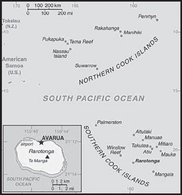
INTRODUCTION
Background: Polynesians from Tahiti were probably the first people to settle Rarotonga around A.D. 900. Over time, Samoans and Tongans also settled in Rarotonga, and Rarotongans voyaged to the northern Cook Islands, settling Manihiki and Rakahanga. Pukapuka and Penrhyn in the northern Cook Islands were settled directly from Samoa. Prior to European contact, there was considerable travel and trade between inhabitants of the different islands and atolls but they were not united in a single political entity. Spanish navigators were the first Europeans to spot the northern Cook Islands in 1595 followed by the first landing in 1606. The Cook Islands remained free of further European contact until the 1760s, and in 1773, British explorer James COOK saw Manuae in the southern Cook Islands. The islands were named after COOK in the 1820s by Russian mapmakers. English missionary activity during the 1820s and 1830s banned singing and dancing and converted most of the population.
Fearing France would militarily occupy the islands like it did in Tahiti, Rarotongans asked the UK for protectorate status in the 1840s and 1860s, which the UK ignored. In 1888, Queen MAKEA TAKAU of Rarotonga formally petitioned for protectorate status, which the UK reluctantly agreed to. In 1901, the UK placed Rarotonga and the rest of the islands in the New Zealand Colony and in 1915, the Cook Islands Act organized the Cook Islands into one political entity. It remained a protectorate until 1965, when New Zealand granted the Cook Islands self-government status. The Cook Islands has a great deal of local autonomy and is an independent member of international organizations, but it is in free association with New Zealand, which is responsible for defense and foreign affairs. In September 2023, the US recognized the Cook Islands as a sovereign and independent state.
GEOGRAPHY
Location: Oceania, group of islands in the South Pacific Ocean, about halfway between Hawaii and New Zealand
Geographic coordinates: 21 14 S, 159 46 W
Map references: Oceania
Area: total: 236 sq km
land: 236 sq km
water: 0 sq km
comparison ranking: total 214
Area - comparative: 1.3 times the size of Washington, DC
Land boundaries: total: 0 km
Coastline: 120 km
Maritime claims: territorial sea: 12 nm
exclusive economic zone: 200 nm
continental shelf: 200 nm or to the edge of the continental margin
Climate: tropical oceanic; moderated by trade winds; a dry season from April to November and a more humid season from December to March
Terrain: low coral atolls in north; volcanic, hilly islands in south
Elevation: highest point: Te Manga 652 m
lowest point: Pacific Ocean 0 m
Natural resources: coconuts (copra)
Land use: agricultural land: 8.4% (2018 est.)
arable land: 4.2% (2018 est.)
permanent crops: 4.2% (2018 est.)
permanent pasture: 0% (2018 est.)
forest: 64.6% (2018 est.)
other: 27% (2018 est.)
Population distribution: most of the population is found on the island of Rarotonga
Natural hazards: tropical cyclones (November to March)
Geography - note: the northern Cook Islands are seven low-lying, sparsely populated, coral atolls; the southern Cook Islands, where most of the population lives, consist of eight elevated, fertile, volcanic isles, including the largest, Rarotonga, at 67 sq km
PEOPLE AND SOCIETY
Population: 7,939 (2023 est.)
note: the Cook Islands’ Ministry of Finance & Economic Management estimated the resident population to have been 11,700 in September 2016
comparison ranking: 223
Nationality: noun: Cook Islander(s)
adjective: Cook Islander
Ethnic groups: Cook Island Maori (Polynesian) 81.3%, part Cook Island Maori 6.7%, other 11.9% (2011 est.)
Languages: English (official) 86.4%, Cook Islands Maori (Rarotongan) (official) 76.2%, other 8.3% (2011 est.)
note: shares sum to more than 100% because some respondents gave more than one answer on the census
Religions: Protestant 62.8% (Cook Islands Christian Church 49.1%, Seventh Day Adventist 7.9%, Assemblies of God 3.7%, Apostolic Church 2.1%), Roman Catholic 17%, Church of Jesus Christ 4.4%, other 8%, none 5.6%, no response 2.2% (2011 est.)
Age structure: 0-14 years: 18.43% (male 766/female 697)
15-64 years: 66.23% (male 2,713/female 2,545)
65 years and over: 15.34% (2023 est.) (male 596/female 622)
Dependency ratios: total dependency ratio: 53.8
youth dependency ratio: 36.4
elderly dependency ratio: 17.4
potential support ratio: 5.8 (2021)
Median age: total: 38.3 years (2020)
male: 37.8 years
female: 38.7 years
comparison ranking: total 64
Population growth rate: -2.31% (2023 est.)
comparison ranking: 236
Birth rate: 12.34 births/1,000 population (2023 est.)
comparison ranking: 145
Death rate: 9.2 deaths/1,000 population (2023 est.)
comparison ranking: 54
Net migration rate: -26.2 migrant(s)/1,000 population (2023 est.)
comparison ranking: 230
Population distribution: most of the population is found on the island of Rarotonga
Urbanization: urban population: 76.2% of total population (2023)
rate of urbanization: 0.52% annual rate of change (2020-25 est.)
Sex ratio: at birth: 1.04 male(s)/female
0-14 years: 1.1 male(s)/female
15-64 years: 1.07 male(s)/female
65 years and over: 0.96 male(s)/female
total population: 1.05 male(s)/female (2023 est.)
Infant mortality rate: total: 15.53 deaths/1,000 live births (2023 est.)
male: 19.52 deaths/1,000 live births
female: 11.34 deaths/1,000 live births
comparison ranking: total 93
Life expectancy at birth: total population: 77.39 years (2023 est.)
male: 74.58 years
female: 80.34 years
comparison ranking: total population 94
Total fertility rate: 2.04 children born/woman (2023 est.)
comparison ranking: 99
Gross reproduction rate: 1 (2023 est.)
Drinking water source: improved:
total: 100% of population
unimproved: total: 0% of population (2020 est.)
Current health expenditure: 3.2% of GDP (2020)
Physicians density: 1.41 physicians/1,000 population (2014)
Sanitation facility access: improved:
total: 99.1% of population
unimproved: total: 0.9% of population (2020 est.)
Obesity - adult prevalence rate: 55.9% (2016)
comparison ranking: 2
Alcohol consumption per capita: total: 12.97 liters of pure alcohol (2019 est.)
beer: 3.62 liters of pure alcohol (2019 est.)
wine: 2.28 liters of pure alcohol (2019 est.)
spirits: 7.07 liters of pure alcohol (2019 est.)
other alcohols: 0 liters of pure alcohol (2019 est.)
comparison ranking: total 1
Tobacco use: total: 24% (2020 est.)
male: 27.7% (2020 est.)
female: 20.3% (2020 est.)
comparison ranking: total 60
Currently married women (ages 15-49): 42.6% (2023 est.)
Education expenditures: 4.6% of GDP (2021 est.)
comparison ranking: 92
School life expectancy (primary to tertiary education): total: 15 years
male: 15 years
female: 14 years (2012)
ENVIRONMENT
Environment - current issues: limited land presents solid and liquid waste disposal problems; soil destruction and deforestation; environmental degradation due to indiscriminate use of pesticides; improper disposal of pollutants; overfishing and destructive fishing practices; over dredging of lagoons and coral rubble beds; unregulated building
Environment - international agreements: party to: Antarctic-Marine Living Resources, Biodiversity, Climate Change, Climate Change-Kyoto Protocol, Climate Change-Paris Agreement, Comprehensive Nuclear Test Ban, Desertification, Hazardous Wastes, Law of the Sea, Ozone Layer Protection, Ship Pollution
signed, but not ratified: none of the selected agreements
Climate: tropical oceanic; moderated by trade winds; a dry season from April to November and a more humid season from December to March
Land use: agricultural land: 8.4% (2018 est.)
arable land: 4.2% (2018 est.)
permanent crops: 4.2% (2018 est.)
permanent pasture: 0% (2018 est.)
forest: 64.6% (2018 est.)
other: 27% (2018 est.)
Urbanization: urban population: 76.2% of total population (2023)
rate of urbanization: 0.52% annual rate of change (2020-25 est.)
Air pollutants: particulate matter emissions: 7.8 micrograms per cubic meter (2019 est.)
Total renewable water resources: 0 cubic meters (2017 est.)
GOVERNMENT
Country name: conventional long form: none
conventional short form: Cook Islands
former: Hervey Islands
etymology: named after Captain James COOK, the British explorer who visited the islands in 1773 and 1777
Government type: parliamentary democracy
Dependency status: self-governing in free association with New Zealand; Cook Islands is fully responsible for internal affairs; New Zealand retains responsibility for external affairs and defense in consultation with the Cook Islands
Capital: name: Avarua
geographic coordinates: 21 12 S, 159 46 W
time difference: UTC-10 (5 hours behind Washington, DC, during Standard Time)
etymology: translates as “two harbors” in Maori
Administrative divisions: none
Independence: 4 August 1965 (Cook Islands became self-governing state in free association with New Zealand)
National holiday: Constitution Day, the first Monday in August (1965)
Constitution: history: 4 August 1965 (Cook Islands Constitution Act 1964)
amendments: proposed by Parliament; passage requires at least two-thirds majority vote by the Parliament membership in each of several readings and assent of the chief of state’s representative; passage of amendments relating to the chief of state also requires two-thirds majority approval in a referendum; amended many times, last in 2004
Legal system: common law similar to New Zealand common law
International law organization participation: has not submitted an ICJ jurisdiction declaration (New Zealand normally retains responsibility for external affairs); accepts ICCt jurisdiction
Suffrage: 18 years of age; universal
Executive branch: chief of state: King CHARLES III (since 8 September 2022); represented by Sir Tom J. MARSTERS (since 9 August 2013); New Zealand High Commissioner Ms Tui DEWES (since October 2020)
head of government: Prime Minister Mark BROWN (since 1 October 2020)
cabinet: Cabinet chosen by the prime minister
elections/appointments: the monarchy is hereditary; UK representative appointed by the monarch; New Zealand high commissioner appointed by the New Zealand Government; following legislative elections, the leader of the majority party or majority coalition usually becomes prime minister
Legislative branch: description: unicameral Parliament, formerly the Legislative Assembly (24 seats; members directly elected in single-seat constituencies by simple majority vote to serve 4-year terms); note - the House of Ariki, a 24-member parliamentary body of traditional leaders appointed by the King’s representative serves as a consultative body to the Parliament
elections: last held on 1 August 2022 (next to be held by 2026)
election results: percent of vote by party - CIP 44%, Demo 26.9%, Cook Islands United Party 26.9%, OCI 2.7%, other 0.2% independent 7.3%; seats by party - CIP 12, Demo 5, Cook Islands United Party 3, OCI 1, independent 3; composition as of September 2023 - men 18, women 6, percent of women 25%
Judicial branch: highest court(s): Court of Appeal (consists of the chief justice and 3 judges of the High Court); High Court (consists of the chief justice and at least 4 judges and organized into civil, criminal, and land divisions); note - appeals beyond the Cook Islands Court of Appeal are heard by the Judicial Committee of the Privy Council (in London)
judge selection and term of office: High Court chief justice appointed by the Queen’s Representative on the advice of the Executive Council tendered by the prime minister; other judges appointed by the Queen’s Representative, on the advice of the Executive Council tendered by the chief justice, High Court chief justice, and the minister of justice; chief justice and judges appointed for 3-year renewable terms
subordinate courts: justices of the peace
Political parties and leaders: Cook Islands Party or CIP [Mark BROWN]
Cook Islands United Party [Teariki HEATHER]
Democratic Party or Demo [Tina BROWNE]
One Cook Islands Movement or OCI [George TURIA]
International organization participation: ACP, ADB, AOSIS, FAO, ICAO, ICCt, ICRM, IFAD, IFRCS, IMO, IMSO, IOC, ITUC (NGOs), OPCW, PIF, Sparteca, SPC, UNESCO, UPU, WHO, WMO
Diplomatic representation in the US: none (self-governing in free association with New Zealand)
Diplomatic representation from the US: embassy: none (self-governing in free association with New Zealand)
note: on 25 September 2023, the US officially established diplomatic relations with Cook Islands
Flag description: blue with the flag of the UK in the upper hoist-side quadrant and a large circle of 15 white five-pointed stars (one for every island) centered in the outer half of the flag
National symbol(s): a circle of 15, five-pointed, white stars on a blue field, Tiare maori (Gardenia taitensis) flower; national colors: green, white
National anthem: name: “Te Atua Mou E” (To God Almighty)
lyrics/music: Tepaeru Te RITO/Thomas DAVIS
note: adopted 1982; as prime minister, Sir Thomas DAVIS composed the anthem; his wife, a tribal chief, wrote the lyrics
ECONOMY
Economic overview: high-income self-governing New Zealand territorial economy; tourism-based activity but diversifying; severely curtailed by COVID-19 pandemic; copra and tropical fruit exporter; Asian Development Bank aid recipient
Real GDP (purchasing power parity): $266 million (2022 est.)
$257 million (2021 est.)
$287 million (2020 est.)
note: data are in 2015 dollars
comparison ranking: 216
Real GDP growth rate: 10.5% (2022 est.)
-24.5% (2021 est.)
-5.2% (2020 est.)
comparison ranking: 25
Real GDP per capita: $15,600 (2022 est.)
$15,100 (2021 est.)
$16,800 (2020 est.)
note: data are in 2015 dollars
comparison ranking: 104
GDP (official exchange rate)
$336 million (2022 est.)
Inflation rate (consumer prices): 2.2% (2011 est.)
comparison ranking: 149
GDP - composition, by sector of origin
agriculture: 5.1% (2010 est.)
industry: 12.7% (2010 est.)
services: 82.1% (2010 est.)
comparison rankings: services 27; industry 196; agriculture 126
Agricultural products: vegetables, coconuts, roots/tubers, cassava, papayas, tomatoes, pork, fruit, sweet potatoes, mangoes/guavas
Industries: fishing, fruit processing, tourism, clothing, handicrafts
Industrial production growth rate: 1% (2002)
comparison ranking: 152
Labor force: 6,820 (2001)
comparison ranking: 218
Labor force - by occupation: agriculture: 29%
industry: 15%
services: 56% (1995)
Unemployment rate: 13.1% (2005)
comparison ranking: 50
Budget: revenues: $86.9 million (2010)
expenditures: $77.9 million (2010)
Budget surplus (+) or deficit (-): 3% (of GDP) (2010 est.)
comparison ranking: 13
Taxes and other revenues: 29% (of GDP) (2010 est.)
comparison ranking: 31
Fiscal year: 1 April - 31 March
Current account balance: $26.67 million (2005)
comparison ranking: 70
Exports: $31.4 million (2021 est.)
$3.125 million (2011 est.)
$5.163 million (2010 est.)
note: Data are in current year dollars and do not include illicit exports or re-exports.
comparison ranking: 214
Exports - partners: Japan 41%, France 18%, Thailand 16%, Greece 7%, China 6% (2021)
Exports - commodities: fish products, recreational boats, paintings, lobsters, tuna (2021)
Imports: $215 million (2021 est.)
$109.3 million (2011 est.)
$90.62 million (2010 est.)
comparison ranking: 210
Imports - partners: New Zealand 57%, Turkey 12%, Italy 11%, Israel 5%, Fiji 4% (2021)
Imports - commodities: motorboats, refined petroleum, integrated circuits, lumber, cars, edible preparations, flavored water, beer (2021)
Debt - external: $141 million (1996 est.)
comparison ranking: 191
Exchange rates: NZ dollars (NZD) per US dollar -
Exchange rates:: 1.416 (2017 est.)
1.4341 (2016 est.)
1.4341 (2015 est.)
1.441 (2014 est.)
1.4279 (2013 est.)
ENERGY
Electricity: installed generating capacity: 18,000 kW (2020 est.)
consumption: 38.729 million kWh (2019 est.)
exports: 0 kWh (2020 est.)
imports: 0 kWh (2020 est.)
transmission/distribution losses: 3 million kWh (2019 est.)
comparison rankings: imports 189; exports 184; installed generating capacity 205; transmission/distribution losses 204; consumption 203
Electricity generation sources: fossil fuels: 70% of total installed capacity (2020 est.)
solar: 30% of total installed capacity (2020 est.)
Petroleum: total petroleum production: 0 bbl/day (2021 est.)
refined petroleum consumption: 800 bbl/day (2019 est.)
Refined petroleum products - imports: 611 bbl/day (2015 est.)
comparison ranking: 204
Carbon dioxide emissions: 114,000 metric tonnes of CO2 (2019 est.)
from petroleum and other liquids: 114,000 metric tonnes of CO2 (2019 est.)
comparison ranking: total emissions 208
Energy consumption per capita: 0 Btu/person (2019 est.)
comparison ranking: 197
COMMUNICATIONS
Telephones - fixed lines: total subscriptions: 7,000 (2021 est.)
subscriptions per 100 inhabitants: 41 (2021 est.)
comparison ranking: total subscriptions 196
Telephones - mobile cellular: total subscriptions: 17,000 (2021 est.)
subscriptions per 100 inhabitants: 100 (2021 est.)
comparison ranking: total subscriptions 217
Telecommunication systems: general assessment: demand for mobile broadband is increasing due to mobile services being the primary and most wide-spread source for Internet access across the region; Telecom Cook Islands offers international direct dialing, Internet, email, and fax; individual islands are connected by a combination of satellite earth stations, microwave systems, and VHF and HF radiotelephone (2020)
domestic: service is provided by small exchanges connected to subscribers by open-wire, cable, and fiber-optic cable; nearly 41 per 100 fixed-line and about 100 per 100 mobile-cellular (2021)
international: country code - 682; the Manatua submarine cable to surrounding islands of Niue, Samoa, French Polynesia and other Cook Islands, the topography of the South Pacific region has made Internet connectivity a serious issue for many of the remote islands; submarine fiber-optic networks are expensive to build and maintain; satellite earth station - 1 Intelsat (Pacific Ocean) (2019)
Broadcast media: 1 privately owned TV station broadcasts from Rarotonga providing a mix of local news and overseas-sourced programs (2019)
Internet country code: .ck
Internet users: total: 11,382 (2021 est.)
percent of population: 64.8% (2021 est.)
comparison ranking: total 217
Broadband - fixed subscriptions: total: 2,700 (2018 est.)
subscriptions per 100 inhabitants: 15 (2018 est.)
comparison ranking: total 195
TRANSPORTATION
National air transport system: number of registered air carriers: 1 (2020)
inventory of registered aircraft operated by air carriers: 6
Civil aircraft registration country code prefix: E5
Airports: 11 (2021)
comparison ranking: total 153
Airports - with paved runways: 1
note: paved runways have a concrete or asphalt surface but not all have facilities for refueling, maintenance, or air traffic control; the length of a runway required for aircraft to safely operate depends on a number of factors including the type of aircraft, the takeoff weight (including passengers, cargo, and fuel), engine types, flap settings, landing speed, elevation of the airport, and average maximum daily air temperature; paved runways can reach a length of 5,000 m (16,000 ft.), but the “typical” length of a commercial airline runway is between 2,500-4,000 m (8,000-13,000 ft.)
Airports - with unpaved runways: 10
note: unpaved runways have a surface composition such as grass or packed earth and are most suited to the operation of light aircraft; unpaved runways are usually short, often less than 1,000 m (3,280 ft.) in length; airports with unpaved runways often lack facilities for refueling, maintenance, or air traffic control
Roadways: total: 295 km (2018)
paved: 207 km (2018)
unpaved: 88 km (2018)
comparison ranking: total 202
Merchant marine: total: 189 (2022)
by type: bulk carrier 20, general cargo 53, oil tanker 51, other 65
comparison ranking: total 69
Ports and terminals: major seaport(s): Avatiu
MILITARY AND SECURITY
Military and security forces: no regular military forces; Cook Islands Police Service
Military - note: defense is the responsibility of New Zealand in consultation with the Cook Islands and at its request
the Cook Islands have a “shiprider” agreement with the US, which allows local maritime law enforcement officers to embark on US Coast Guard (USCG) and US Navy (USN) vessels, including to board and search vessels suspected of violating laws or regulations within its designated exclusive economic zone (EEZ) or on the high seas; “shiprider” agreements also enable USCG personnel and USN vessels with embarked USCG law enforcement personnel to work with host nations to protect critical regional resources (2022)
TRANSNATIONAL ISSUES
Disputes - international: none
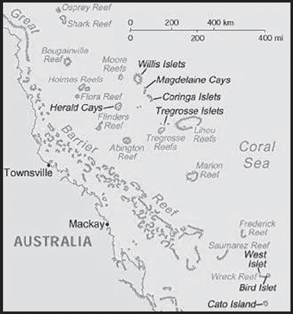
INTRODUCTION
Background: The widely scattered islands were first charted in 1803, but they were too small to host any permanent human habitation. The 1870s and 1880s, saw attempts at guano mining, but these were soon abandoned. The islands became an Australian territory in 1969 and its boundaries were extended in 1997. A small meteorological staff has operated on the Willis Islets since 1921, and several other islands host unmanned weather stations, beacons, and lighthouses. Much of the territory lies within marine national nature reserves.
GEOGRAPHY
Location: Oceania, islands in the Coral Sea, northeast of Australia
Geographic coordinates: 18 00 S, 152 00 E
Map references: Oceania
Area: total: 3 sq km less than
land: 3 sq km less than
water: 0 sq km
note: includes numerous small islands and reefs scattered over a sea area of about 780,000 sq km (300,000 sq mi) with the Willis Islets the most important
comparison ranking: total 253
Area - comparative: about four times the size of the National Mall in Washington, DC
Land boundaries: total: 0 km
Coastline: 3,095 km
Maritime claims: territorial sea: 3 nm
exclusive fishing zone: 200 nm
Climate: tropical
Terrain: sand and coral reefs and islands (cays)
Elevation: highest point: unnamed location on Cato Island 9 m
lowest point: Pacific Ocean 0 m
Natural resources: fish
Land use: agricultural land: 0% (2018 est.)
other: 100% (2018 est.)
Natural hazards: occasional tropical cyclones
Geography - note: important nesting area for birds and turtles
PEOPLE AND SOCIETY
Population: (July 2021 est.) no indigenous inhabitants
note: there is a staff of four at the meteorological station on Willis Island
ENVIRONMENT
Environment - current issues: no permanent freshwater resources; damaging activities include coral mining, destructive fishing practices (overfishing, blast fishing)
Climate: tropical
Land use: agricultural land: 0% (2018 est.)
other: 100% (2018 est.)
GOVERNMENT
Country name: conventional long form: Coral Sea Islands Territory
conventional short form: Coral Sea Islands
etymology: self-descriptive name to reflect the islands’ position in the Coral Sea off the northeastern coast of Australia
Dependency status: territory of Australia; administered from Canberra by the Department of Regional Australia, Local Government, Arts and Sport
Legal system: the common law legal system of Australia applies where applicable
Citizenship: see Australia
Diplomatic representation in the US: none (territory of Australia)
Diplomatic representation from the US: embassy: none (territory of Australia)
Flag description: the flag of Australia is used
COMMUNICATIONS
Communications - note: automatic weather stations on many of the isles and reefs relay data to the mainland
TRANSPORTATION
Ports and terminals: none; offshore anchorage only
MILITARY AND SECURITY
Military - note: defense is the responsibility of Australia
TRANSNATIONAL ISSUES
Disputes - international: none
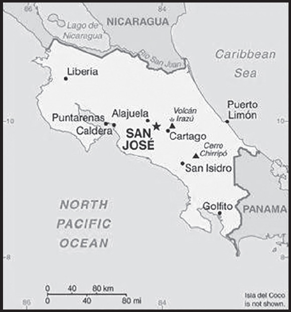
INTRODUCTION
Background: Although explored by the Spanish early in the 16th century, initial attempts at colonizing Costa Rica proved unsuccessful due to a combination of factors, including disease from mosquito-infested swamps, brutal heat, resistance by indigenous populations, and pirate raids. It was not until 1563 that a permanent settlement of Cartago was established in the cooler, fertile central highlands. The area remained a colony for some two and a half centuries. In 1821, Costa Rica became one of several Central American provinces that jointly declared their independence from Spain. Two years later it joined the United Provinces of Central America, but this federation disintegrated in 1838, at which time Costa Rica proclaimed its sovereignty and independence. Since the late 19th century, only two brief periods of violence have marred the country’s democratic development. On 1 December 1948, Costa Rica dissolved its armed forces. Although it still maintains a large agricultural sector, Costa Rica has expanded its economy to include strong technology and tourism industries. The standard of living is relatively high. Land ownership is widespread.
GEOGRAPHY
Location: Central America, bordering both the Caribbean Sea and the North Pacific Ocean, between Nicaragua and Panama
Geographic coordinates: 10 00 N, 84 00 W
Map references: Central America and the Caribbean
Area: total: 51,100 sq km
land: 51,060 sq km
water: 40 sq km
note: includes Isla del Coco
comparison ranking: total 129
Area - comparative: slightly smaller than West Virginia
Land boundaries: total: 661 km
border countries (2): Nicaragua 313 km; Panama 348 km
Coastline: 1,290 km
Maritime claims: territorial sea: 12 nm
exclusive economic zone: 200 nm
continental shelf: 200 nm
Climate: tropical and subtropical; dry season (December to April); rainy season (May to November); cooler in highlands
Terrain: coastal plains separated by rugged mountains including over 100 volcanic cones, of which several are major active volcanoes
Elevation: highest point: Cerro Chirripo 3,819 m
lowest point: Pacific Ocean 0 m
mean elevation: 746 m
Natural resources: hydropower
Land use: agricultural land: 37.1% (2018 est.)
arable land: 4.9% (2018 est.)
permanent crops: 6.7% (2018 est.)
permanent pasture: 25.5% (2018 est.)
forest: 51.5% (2018 est.)
other: 11.4% (2018 est.)
Irrigated land: 1,015 sq km (2012)
Population distribution: roughly half of the nation’s population resides in urban areas; the capital of San Jose is the largest city and home to approximately one-fifth of the population
Natural hazards: occasional earthquakes, hurricanes along Atlantic coast; frequent flooding of lowlands at onset of rainy season and landslides; active volcanoes
volcanism: Arenal (1,670 m), which erupted in 2010, is the most active volcano in Costa Rica; a 1968 eruption destroyed the town of Tabacon; Irazu (3,432 m), situated just east of San Jose, has the potential to spew ash over the capital city as it did between 1963 and 1965; other historically active volcanoes include Miravalles, Poas, Rincon de la Vieja, and Turrialba
Geography - note: four volcanoes, two of them active, rise near the capital of San Jose in the center of the country; one of the volcanoes, Irazu, erupted destructively in 1963-65
PEOPLE AND SOCIETY
Population: 5,256,612 (2023 est.)
comparison ranking: 124
Nationality: noun: Costa Rican(s)
adjective: Costa Rican
Ethnic groups: White or Mestizo 83.6%, Mulatto 6.7%, Indigenous 2.4%, Black or African descent 1.1%, other 1.1%, none 2.9%, unspecified 2.2% (2011 est.)
Languages: Spanish (official), English
major-language sample(s):
La Libreta Informativa del Mundo, la fuente indispensable de información básica. (Spanish)
Religions: Roman Catholic 47.5%, Evangelical and Pentecostal 19.8%, Jehovah’s Witness 1.4%, other Protestant 1.2%, other 3.1%, none 27% (2021 est.)
Demographic profile: Costa Rica’s political stability, high standard of living, and well-developed social benefits system set it apart from its Central American neighbors. Through the government’s sustained social spending - almost 20% of GDP annually - Costa Rica has made tremendous progress toward achieving its goal of providing universal access to education, healthcare, clean water, sanitation, and electricity. Since the 1970s, expansion of these services has led to a rapid decline in infant mortality, an increase in life expectancy at birth, and a sharp decrease in the birth rate. The average number of children born per women has fallen from about 7 in the 1960s to 3.5 in the early 1980s to below replacement level today. Costa Rica’s poverty rate is lower than in most Latin American countries, but it has stalled at around 20% for almost two decades.
Costa Rica is a popular regional immigration destination because of its job opportunities and social programs. Almost 9% of the population is foreign-born, with Nicaraguans comprising nearly three-quarters of the foreign population. Many Nicaraguans who perform unskilled seasonal labor enter Costa Rica illegally or overstay their visas, which continues to be a source of tension. Less than 3% of Costa Rica’s population lives abroad. The overwhelming majority of expatriates have settled in the United States after completing a university degree or in order to work in a highly skilled field.
Age structure: 0-14 years: 21.49% (male 577,782/female 552,041)
15-64 years: 68.59% (male 1,813,827/female 1,791,510)
65 years and over: 9.92% (2023 est.) (male 238,971/female 282,481)
Dependency ratios: total dependency ratio: 45.1
youth dependency ratio: 29.8
elderly dependency ratio: 15.3
potential support ratio: 6.5 (2021 est.)
Median age: total: 32.6 years (2020)
male: 32.1 years
female: 33.1 years
comparison ranking: total 109
Population growth rate: 0.98% (2023 est.)
comparison ranking: 94
Birth rate: 14.03 births/1,000 population (2023 est.)
comparison ranking: 123
Death rate: 4.97 deaths/1,000 population (2023 est.)
comparison ranking: 194
Net migration rate: 0.76 migrant(s)/1,000 population (2023 est.)
comparison ranking: 69
Population distribution: roughly half of the nation’s population resides in urban areas; the capital of San Jose is the largest city and home to approximately one-fifth of the population
Urbanization: urban population: 82.6% of total population (2023)
rate of urbanization: 1.5% annual rate of change (2020-25 est.)
Major urban areas - population: 1.462 million SAN JOSE (capital) (2023)
Sex ratio: at birth: 1.05 male(s)/female
0-14 years: 1.05 male(s)/female
15-64 years: 1.01 male(s)/female
65 years and over: 0.85 male(s)/female
total population: 1 male(s)/female (2023 est.)
Maternal mortality ratio: 22 deaths/100,000 live births (2020 est.)
comparison ranking: 118
Infant mortality rate: total: 8.2 deaths/1,000 live births (2023 est.)
male: 9.24 deaths/1,000 live births
female: 7.12 deaths/1,000 live births
comparison ranking: total 144
Life expectancy at birth: total population: 79.87 years (2023 est.)
male: 77.23 years
female: 82.65 years
Contraceptive prevalence rate: Total fertility rate
1.86 children born/woman (2023 est.)
comparison ranking: 134
Gross reproduction rate: 0.91 (2023 est.)
Contraceptive prevalence rate: 70.9% (2018)
Drinking water source: improved:
total: 100% of population
unimproved: total: 0% of population (2020 est.)
Current health expenditure: 7.9% of GDP (2020)
Physicians density: 3.3 physicians/1,000 population (2020)
Hospital bed density: 1.1 beds/1,000 population (2019)
Sanitation facility access: improved: urban: 99% of population
rural: 97.1% of population
total: 98.7% of population
unimproved: urban: 1% of population
rural: 2.9% of population
total: 1.3% of population (2020 est.)
Major infectious diseases: degree of risk: intermediate (2023)
food or waterborne diseases: bacterial diarrhea
vectorborne diseases: dengue fever
Obesity - adult prevalence rate: 25.7% (2016)
comparison ranking: 48
Alcohol consumption per capita: total: 3.07 liters of pure alcohol (2019 est.)
beer: 2.17 liters of pure alcohol (2019 est.)
wine: 0.15 liters of pure alcohol (2019 est.)
spirits: 0.36 liters of pure alcohol (2019 est.)
other alcohols: 0.39 liters of pure alcohol (2019 est.)
comparison ranking: total 113
Tobacco use: total: 8.8% (2020 est.)
male: 12.9% (2020 est.)
female: 4.6% (2020 est.)
comparison ranking: total 140
Children under the age of 5 years underweight: 2.9% (2018)
comparison ranking: 91
Currently married women (ages 15-49): 48.4% (2023 est.)
Child marriage: women married by age 15: 2%
women married by age 18: 17.1% (2018 est.)
Education expenditures: 6.7% of GDP (2020 est.)
comparison ranking: 26
Literacy: definition: age 15 and over can read and write
total population: 98%
male: 98%
female: 98.1% (2021)
School life expectancy (primary to tertiary education): total: 17 years
male: 16 years
female: 17 years (2019)
Youth unemployment rate (ages 15-24): total: 45.4% (2021 est.)
male: 37%
female: 56.3%
comparison ranking: total 6
ENVIRONMENT
Environment - current issues: deforestation and land use change, largely a result of the clearing of land for cattle ranching and agriculture; soil erosion; coastal marine pollution; fisheries protection; solid waste management; air pollution
Environment - international agreements: party to: Biodiversity, Climate Change, Climate Change-Kyoto Protocol, Climate Change-Paris Agreement, Comprehensive Nuclear Test Ban, Desertification, Endangered Species, Environmental Modification, Hazardous Wastes, Law of the Sea, Marine Dumping-London Convention, Nuclear Test Ban, Ozone Layer Protection, Tropical Timber 2006, Wetlands, Whaling
signed, but not ratified: Marine Life Conservation
Climate: tropical and subtropical; dry season (December to April); rainy season (May to November); cooler in highlands
Land use: agricultural land: 37.1% (2018 est.)
arable land: 4.9% (2018 est.)
permanent crops: 6.7% (2018 est.)
permanent pasture: 25.5% (2018 est.)
forest: 51.5% (2018 est.)
other: 11.4% (2018 est.)
Urbanization: urban population: 82.6% of total population (2023)
rate of urbanization: 1.5% annual rate of change (2020-25 est.)
Revenue from forest resources: 0.82% of GDP (2018 est.)
comparison ranking: 58
Revenue from coal: 0% of GDP (2018 est.)
comparison ranking: 152
Air pollutants: particulate matter emissions: 14.7 micrograms per cubic meter (2019 est.)
carbon dioxide emissions: 8.02 megatons (2016 est.)
methane emissions: 5.61 megatons (2020 est.)
Waste and recycling: municipal solid waste generated annually: 1.46 million tons (2014 est.)
municipal solid waste recycled annually: 18,396 tons (2014 est.)
percent of municipal solid waste recycled: 1.3% (2014 est.)
Total water withdrawal: municipal: 830 million cubic meters (2020 est.)
industrial: 230 million cubic meters (2020 est.)
agricultural: 2.08 billion cubic meters (2020 est.)
Total renewable water resources: 113 billion cubic meters (2020 est.)
GOVERNMENT
Country name: conventional long form: Republic of Costa Rica
conventional short form: Costa Rica
local long form: República de Costa Rica
local short form: Costa Rica
etymology: the name means “rich coast” in Spanish and was first applied in the early colonial period of the 16th century
Government type: presidential republic
Capital: name: San Jose
geographic coordinates: 9 56 N, 84 05 W
time difference: UTC-6 (1 hour behind Washington, DC, during Standard Time)
etymology: named in honor of Saint Joseph
Administrative divisions: 7 provinces (provincias, singular - provincia); Alajuela, Cartago, Guanacaste, Heredia, Limon, Puntarenas, San Jose
Independence: 15 September 1821 (from Spain)
National holiday: Independence Day, 15 September (1821)
Constitution: history: many previous; latest effective 8 November 1949
amendments: proposals require the signatures of at least 10 Legislative Assembly members or petition of at least 5% of qualified voters; consideration of proposals requires two-thirds majority approval in each of three readings by the Assembly, followed by preparation of the proposal as a legislative bill and its approval by simple majority of the Assembly; passage requires at least two-thirds majority vote of the Assembly membership; a referendum is required only if approved by at least two thirds of the Assembly; amended many times, last in 2020
Legal system: civil law system based on Spanish civil code; judicial review of legislative acts in the Supreme Court
International law organization participation: accepts compulsory ICJ jurisdiction; accepts ICCt jurisdiction
Citizenship: citizenship by birth: yes
citizenship by descent only: yes
dual citizenship recognized: yes
residency requirement for naturalization: 7 years
Suffrage: 18 years of age; universal and compulsory
Executive branch: chief of state: President Rodrigo CHAVES Robles (since 8 May 2022); First Vice President Stephan BRUNNER Neibig (since 8 May 2022); Second Vice President Mary Denisse MUNIVE Angermuller (since 8 May 2022); note - the president is both chief of state and head of government
head of government: President Rodrigo CHAVES Robles (since 8 May 2022); First Vice President Stephan BRUNNER Neibig (since 8 May 2022); Second Vice President Mary Denisse MUNIVE Angermuller (since 8 May 2022)
cabinet: Cabinet selected by the president
elections/appointments: president and vice presidents directly elected on the same ballot by modified majority popular vote (40% threshold) for a 4-year term (eligible for non-consecutive terms); election last held on 6 February 2022 with a runoff on 3 April 2022 (next to be held in February 2026 with a runoff in April 2026)
election results:
2022: Rodrigo CHAVES Robles elected president in second round; percent of vote in first round - Jose Maria FIGUERES Olsen (PLN) 27.3%, Rodrigo CHAVES Robles (PPSD) 16.8%, Fabricio ALVARADO Munoz (PNR) 14.9%, Eliecer FEINZAIG Mintz (PLP) 12.4%, Lineth SABORIO Chaverri (PUSC) 12.4%, Jose Maria VILLALTA Florez-Estrada 8.7% (PFA), other 7.5%; percent of vote in second round - Rodrigo CHAVES Robles (PPSD) 52.8%, Jose Maria FIGUERES Olsen (PLN) 47.2%
2018: Carlos ALVARADO Quesada elected president in second round; percent of vote in first round - Fabricio ALVARADO Munoz (PRN) 25%; Carlos ALVARADO Quesada (PAC) 21.6%; Antonio ALVAREZ (PLN) 18.6%; Rodolfo PIZA (PUSC) 16%; Juan Diego CASTRO (PIN) 9.5%; Rodolfo HERNANDEZ (PRS) 4.9%, other 4.4%; percent of vote in second round - Carlos ALVARADO Quesada (PAC) 60.7%; Fabricio ALVARADO Munoz (PRN) 39.3%
Legislative branch: description: unicameral Legislative Assembly or Asamblea Legislativa (57 seats; members directly elected in multi-seat constituencies - corresponding to the country’s 7 provinces - by closed party-list proportional representation vote; members serve 4-year terms)
elections: last held on 6 February 2022 (next to be held in February 2026)
election results: percent of vote by party - PLN 24.8%, PPSD 15%, PUSC 11.4%, PNR 10.1%, PLP 9.1%, 8.3%, other 21.3%; seats by party - PLN 19, PPSD 10, PUSC 9, PNR 7, PLP 6, PFA 6; composition - men 30, women 27, percent of women 47.4%
Judicial branch: highest court(s): Supreme Court of Justice (consists of 22 judges organized into 3 cassation chambers each with 5 judges and the Constitutional Chamber with 7 judges)
judge selection and term of office: Supreme Court of Justice judges elected by the National Assembly for 8-year terms with renewal decided by the National Assembly
subordinate courts: appellate courts; trial courts; first instance and justice of the peace courts; Superior Electoral Tribunal
Political parties and leaders: Accessibility Without Exclusion or PASE [Oscar Andres LOPEZ Arias]
Broad Front (Frente Amplio) or PFA [Ana Patricia MORA Castellanos]
Christian Democratic Alliance or ADC [Mario REDONDO Poveda]
Citizen Action Party or PAC [Marta Eugenia SOLANO Arias]
Costa Rican Renewal Party or PRC [Justo OROZCO Alvarez]
Liberal Progressive Party or PLP [Eliecer FEINZAIG Mintz]
Libertarian Movement Party or ML [Victor Danilo CUBERO Corrales]
National Integration Party or PIN [Walter MUNOZ Cespedes]
National Liberation Party or PLN [Kattia RIVERA Soto]
National Restoration Party or PRN [Carlos Luis AVENDANO Calvo]
New Generation or PNG [Rodolfo SOLIS Herrera]
New Republic Party or PNR [Francisco Javier PRENDAS Rodriguez]
Patriotic Alliance [Jorge ARAYA Westover]
Social Christian Republican Party or PRS [Otto ROBERTO Vargas]
Social Christian Unity Party or PUSC of UNIDAD [Randall QUIROS Bustamante]
Social Democratic Progress Party or PPSD [Luz Mary ALPIZAR Loaiza]
International organization participation: BCIE, CACM, CD, CELAC, FAO, G-77, IADB, IAEA, IBRD, ICAO, ICC (national committees), ICCt, ICRM, IDA, IFAD, IFC, IFRCS, ILO, IMF, IMO, IMSO, Interpol, IOC, IOM, IPU, ISO, ITSO, ITU, ITUC (NGOs), LAES, LAIA (observer), MIGA, NAM (observer), OAS, OIF (observer), OPANAL, OPCW, Pacific Alliance (observer), PCA, SICA, UN, UNCTAD, UNESCO, UNHCR, UNIDO, Union Latina, UNWTO, UPU, WCO, WFTU (NGOs), WHO, WIPO, WMO, WTO
Diplomatic representation in the US: chief of mission: Ambassador Catalina CRESPO SANCHO (since 19 April 2023)
chancery: 2114 S Street NW, Washington, DC 20008
telephone: [1] (202) 499-2980
FAX: [1] (202) 265-4795
email address and website:
http://www.costarica-embassy.org/index.php?q=node/21
consulate(s) general: Atlanta, Chicago, Houston, Los Angeles, Miami, New York, Washington DC
honorary consulate(s): San Juan (Puerto Rico), Saint Paul (MN), Tucson (AZ)
Diplomatic representation from the US: chief of mission: Ambassador Cynthia A. TELLES (since 11 March 2022)
embassy: Calle 98 Via 104, Pavas, San Jose
mailing address: 3180 St. George’s Place, Washington DC 20521-3180
telephone: [506] 2519-2000
FAX: [506] 2519-2305
email address and website:
Flag description: five horizontal bands of blue (top), white, red (double width), white, and blue, with the coat of arms in a white elliptical disk placed toward the hoist side of the red band; Costa Rica retained the earlier blue-white-blue flag of Central America until 1848 when, in response to revolutionary activity in Europe, it was decided to incorporate the French colors into the national flag and a central red stripe was added; today the blue color is said to stand for the sky, opportunity, and perseverance, white denotes peace, happiness, and wisdom, while red represents the blood shed for freedom, as well as the generosity and vibrancy of the people
note: somewhat resembles the flag of North Korea; similar to the flag of Thailand but with the blue and red colors reversed
National symbol(s): yiguirro (clay-colored robin); national colors: blue, white, red
National anthem: name: “Himno Nacional de Costa Rica” (National Anthem of Costa Rica)
lyrics/music: Jose Maria ZELEDON Brenes/Manuel Maria GUTIERREZ
note: adopted 1949; the anthem’s music was originally written for an 1853 welcome ceremony for diplomatic missions from the US and UK; the lyrics were added in 1903
National heritage: total World Heritage Sites: 4 (1 cultural, 3 natural)
selected World Heritage Site locales: Guanacaste Conservation Area (n); Cocos Island National Park (n); Precolumbian Stone Spheres (c); La Amistad International Park (n)
ECONOMY
Economic overview: trade-based upper middle-income economy; green economy leader, having reversed deforestation; investing in blue economy infrastructure; declining poverty until hard impacts of COVID-19; lingering inequality and growing government debts have prompted a liquidity crisis
Real GDP (purchasing power parity): $109.26 billion (2021 est.)
$101.562 billion (2020 est.)
$105.85 billion (2019 est.)
note: data are in 2017 dollars
comparison ranking: 88
Real GDP growth rate: 7.58% (2021 est.)
-4.05% (2020 est.)
2.42% (2019 est.)
comparison ranking: 47
Real GDP per capita: $21,200 (2021 est.)
$19,800 (2020 est.)
$20,800 (2019 est.)
note: data are in 2017 dollars
comparison ranking: 87
GDP (official exchange rate)
$61.855 billion (2019 est.)
Inflation rate (consumer prices): 1.73% (2021 est.)
0.72% (2020 est.)
2.1% (2019 est.)
comparison ranking: 168
Credit ratings: Fitch rating: B (2020)
Moody’s rating: B2 (2020)
Standard & Poors rating: B (2020)
note: The year refers to the year in which the current credit rating was first obtained.
GDP - composition, by sector of origin
agriculture: 5.5% (2017 est.)
industry: 20.6% (2017 est.)
services: 73.9% (2017 est.)
comparison rankings: services 53; industry 143; agriculture 125
GDP - composition, by end use
household consumption: 64.2% (2017 est.)
government consumption: 17.3% (2017 est.)
investment in fixed capital: 17.1% (2017 est.)
investment in inventories: 1% (2017 est.)
exports of goods and services: 33.3% (2017 est.)
imports of goods and services: -32.9% (2017 est.)
Agricultural products: sugar cane, pineapples, bananas, milk, oil palm fruit, fruit, oranges, watermelons, cassava, rice
Industries: medical equipment, food processing, textiles and clothing, construction materials, fertilizer, plastic products
Industrial production growth rate: 9.83% (2021 est.)
comparison ranking: 29
Labor force: 2.426 million (2021 est.)
note: official estimate; excludes Nicaraguans living in Costa Rica
comparison ranking: 118
Labor force - by occupation: agriculture: 14%
industry: 22%
services: 64% (2006 est.)
Unemployment rate: 17.95% (2021 est.)
17.41% (2020 est.)
11.49% (2019 est.)
comparison ranking: 25
Youth unemployment rate (ages 15-24): total: 45.4% (2021 est.)
male: 37%
female: 56.3%
comparison ranking: total 6
Population below poverty line: 21% (2019 est.)
Gini Index coefficient - distribution of family income: 49.3 (2020 est.)
comparison ranking: 14
Average household expenditures: on food: 25.7% of household expenditures (2018 est.)
on alcohol and tobacco: 1.2% of household expenditures (2018 est.)
Household income or consumption by percentage share: lowest 10%: 1.5%
highest 10%: 36.9% (2014 est.)
Budget: revenues: $9.664 billion (2019 est.)
expenditures: $14.001 billion (2019 est.)
Budget surplus (+) or deficit (-): -6.1% (of GDP) (2017 est.)
comparison ranking: 185
Public debt: 48.9% of GDP (2017 est.)
44.9% of GDP (2016 est.)
comparison ranking: 111
Taxes and other revenues: 12.32% (of GDP) (2020 est.)
comparison ranking: 174
Fiscal year: calendar year
Current account balance: -$2.136 billion (2021 est.)
-$638.741 million (2020 est.)
-$826.158 million (2019 est.)
comparison ranking: 161
Exports: $23.761 billion (2021 est.)
$19.996 billion (2020 est.)
$22.738 billion (2019 est.)
note: Data are in current year dollars and do not include illicit exports or re-exports.
comparison ranking: 82
Exports - partners: United States 38%, Netherlands 6%, Belgium 5%, Guatemala 5%, Panama 5% (2019)
Exports - commodities: medical instruments, bananas, pineapples, orthopedic appliances, food preparations (2021)
Imports: $22.298 billion (2021 est.) note: data are in current year dollars
$17.701 billion (2020 est.) note: data are in current year dollars
$20.314 billion (2019 est.)
comparison ranking: 87
Imports - partners: United States 41%, China 13%, Mexico 7% (2019)
Imports - commodities: refined petroleum, broadcasting equipment, cars, medical instruments, packaged medicines (2019)
Reserves of foreign exchange and gold: $6.921 billion (31 December 2021 est.)
$7.232 billion (31 December 2020 est.)
$8.937 billion (31 December 2019 est.)
comparison ranking: 95
Debt - external: $29.589 billion (2019 est.)
$28.553 billion (2018 est.)
comparison ranking: 85
Exchange rates: Costa Rican colones (CRC) per US dollar -
Exchange rates:: 620.785 (2021 est.)
584.901 (2020 est.)
587.295 (2019 est.)
576.973 (2018 est.)
567.513 (2017 est.)
ENERGY
Electricity access: electrification - total population: 100% (2021)
Electricity: installed generating capacity: 3.674 million kW (2020 est.)
consumption: 10,072,472,000 kWh (2019 est.)
exports: 712 million kWh (2019 est.)
imports: 733 million kWh (2019 est.)
transmission/distribution losses: 1,321,498,000 kWh (2019 est.)
comparison rankings: installed generating capacity 100; transmission/distribution losses 102; imports 79; exports 67; consumption 101
Electricity generation sources: fossil fuels: 0.2% of total installed capacity (2020 est.)
solar: 0.6% of total installed capacity (2020 est.)
wind: 12.5% of total installed capacity (2020 est.)
hydroelectricity: 71.1% of total installed capacity (2020 est.)
geothermal: 14.5% of total installed capacity (2020 est.)
biomass and waste: 1.2% of total installed capacity (2020 est.)
Petroleum: total petroleum production: 400 bbl/day (2021 est.)
refined petroleum consumption: 63,300 bbl/day (2019 est.)
crude oil estimated reserves: 0 barrels (2021 est.)
Refined petroleum products - imports: 51,320 bbl/day (2015 est.)
comparison ranking: 80
Carbon dioxide emissions: 8.115 million metric tonnes of CO2 (2019 est.)
from coal and metallurgical coke: 1,000 metric tonnes of CO2 (2019 est.)
from petroleum and other liquids: 8.114 million metric tonnes of CO2 (2019 est.)
comparison ranking: total emissions 111
Energy consumption per capita: 44.899 million Btu/person (2019 est.)
comparison ranking: 103
COMMUNICATIONS
Telephones - fixed lines: total subscriptions: 553,455 (2021 est.)
subscriptions per 100 inhabitants: 11 (2021 est.)
comparison ranking: total subscriptions 89
Telephones - mobile cellular: total subscriptions: 7,834,435 (2021 est.)
subscriptions per 100 inhabitants: 152 (2021 est.)
comparison ranking: total subscriptions 102
Telecommunication systems: general assessment: the fixed broadband market is one of the few parts of Costa Rica’s telecom sector to experience solid growth in recent years, both in size and revenue; the country’s fiber network expanded by 56% in 2020, reaching about 176,200km; fixed-line broadband traffic volume also increased by more than 30%, year-on-year; other areas of the market have proven relatively lack luster, with slow or even negative growth; some of this can be attributed to the economic and social impacts of the pandemic, but the fixed-line and mobile sectors have both been struggling to produce decent results since well before the start of the crisis; the rollout of 5G network infrastructure in Costa Rica is unlikely to occur to any scale before 2023, but this may be one of the few remaining areas of opportunity open to investors outside of fixed-line internet and pay TV services (2021)
domestic: roughly 11 per 100 fixed-line and 152 per 100 mobile-cellular (2021)
international: country code - 506; landing points for the ARCOS-1, MAYA-1, and the PAC submarine cables that provide links to South and Central America, parts of the Caribbean, and the US; connected to Central American Microwave System; satellite earth stations - 2 Intelsat (Atlantic Ocean) (2019)
Broadcast media: over two dozen privately owned TV stations and 1 publicly owned TV station nationwide; cable network services are widely available; more than 100 privately owned radio stations and a public radio network (2022)
Internet country code: .cr
Internet users: total: 4.316 million (2021 est.)
percent of population: 83% (2021 est.)
comparison ranking: total 105
Broadband - fixed subscriptions: total: 992,725 (2020 est.)
subscriptions per 100 inhabitants: 20 (2020 est.)
comparison ranking: total 74
TRANSPORTATION
National air transport system: number of registered air carriers: 1 (2020)
inventory of registered aircraft operated by air carriers: 39
annual passenger traffic on registered air carriers: 1,948,546 (2018)
annual freight traffic on registered air carriers: 11.13 million (2018) mt-km
Civil aircraft registration country code prefix: TI
Airports: 161 (2021)
comparison ranking: total 34
Airports - with paved runways: 47
note: paved runways have a concrete or asphalt surface but not all have facilities for refueling, maintenance, or air traffic control; the length of a runway required for aircraft to safely operate depends on a number of factors including the type of aircraft, the takeoff weight (including passengers, cargo, and fuel), engine types, flap settings, landing speed, elevation of the airport, and average maximum daily air temperature; paved runways can reach a length of 5,000 m (16,000 ft.), but the “typical” length of a commercial airline runway is between 2,500-4,000 m (8,000-13,000 ft.)
Airports - with unpaved runways: 114
note: unpaved runways have a surface composition such as grass or packed earth and are most suited to the operation of light aircraft; unpaved runways are usually short, often less than 1,000 m (3,280 ft.) in length; airports with unpaved runways often lack facilities for refueling, maintenance, or air traffic control
Pipelines: 662 km refined products (2013)
Railways: total: 278 km (2014)
narrow gauge: 278 km (2014) 1.067-m gauge
note: the entire rail network fell into disrepair and out of use at the end of the 20th century; since 2005, certain sections of rail have been rehabilitated
comparison ranking: total 124
Roadways: total: 5,035 km (2017)
paved: (2010)
unpaved: (2010)
comparison ranking: total 147
Waterways: 730 km (2011) (seasonally navigable by small craft)
comparison ranking: 80
Merchant marine: total: 11 (2022)
by type: other 11
comparison ranking: total 154
Ports and terminals: major seaport(s): Atlantic Ocean (Caribbean) - Puerto Limon
container port(s) (TEUs): Puerto Limon (1,319,372)
Pacific Ocean - Caldera
MILITARY AND SECURITY
Military and security forces: no regular military forces; Ministry of Public Security: the Public Force (Fuerza Pública (National Police)), Air Surveillance Service (Servicio de Vigilancia Aérea), National Coast Guard Service (Servicio Nacional de Guardacostas), Border Police (Policia de Fronteras); Ministry of Presidency: Directorate of Intelligence and Security (DIS), Special Intervention Unit (UEI) (2023)
note: Costa Rica’s armed forces were constitutionally abolished in 1949
Military expenditures: 0.6% of GDP (2022 est.)
0.7% of GDP (2021 est.)
0.7% of GDP (2020 est.)
0.7% of GDP (2019 est.)
0.7% of GDP (2018 est.)
comparison ranking: 153
Military and security service personnel strengths: 12-15,000 Ministry of Public Security personnel (2023)
Military equipment inventories and acquisitions: the Public Force is lightly armed with an inventory that includes mostly older, secondhand US equipment (2023)
Military - note: Costa Rica relies on specialized paramilitary units within the Ministry of Public Security (MPS) for internal security missions and countering transnational threats such as narcotics smuggling and organized crime, as well as for participating in regional security operations and exercises; MPS forces have received advisory and training support from both Colombia and the US; since 2012, the US has also provided some military equipment, including aircraft and patrol boats (2022)
SPACE
Space agency/agencies: Costa Rican Space Agency (ACE; established 2021); ACE is a non-state, public entity subject to guidelines issued by the Ministry of Science, Technology, and Telecommunications (2023)
Space program overview: has a small, new program focused on promoting the use of space to develop the country’s economy and industry, including acquiring and utilizing satellites; has built a remote sensing (RS) cube satellite; has relations with the space agencies and commercial space industries of the US and members of the Latin American and Caribbean Space Agency (ALCE) (2023)
note: further details about the key activities, programs, and milestones of the country’s space program, as well as government spending estimates on the space sector, appear in Appendix S
TRANSNATIONAL ISSUES
Disputes - international: Costa Rica and Nicaragua regularly file border dispute cases over the delimitations of the San Juan River and the northern tip of Calero Island to the International Court of Justice (ICJ); in 2009, the ICJ ruled that Costa Rican vessels carrying out police activities could not use the river, but official Costa Rican vessels providing essential services to riverside inhabitants and Costa Rican tourists could travel freely on the river; in 2011, the ICJ provisionally ruled that both countries must remove personnel from the disputed area; in 2013, the ICJ rejected Nicaragua’s 2012 suit to halt Costa Rica’s construction of a highway paralleling the river on the grounds of irreparable environmental damage; in 2013, the ICJ, regarding the disputed territory, ordered that Nicaragua should refrain from dredging or canal construction and refill and repair damage caused by trenches connecting the river to the Caribbean and upheld its 2010 ruling that Nicaragua must remove all personnel; in early 2014, Costa Rica brought Nicaragua to the ICJ over offshore oil concessions in the disputed region
Refugees and internally displaced persons: refugees (country of origin): 29,906 (Venezuela) (economic and political crisis; includes Venezuelans who have claimed asylum, are recognized as refugees, or received alternative legal stay) (2021)
stateless persons: 192 (2022)
Illicit drugs: Costa Rica remains a significant transshipment point for cocaine enroute to the United States from South America; a key transit point in international narcotics trafficking; transit and warehousing hub for illicit drug trafficking; growing domestic drug consumption problem; a major source of precursor or essential chemicals used in the production of illicit narcotics
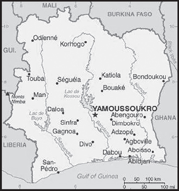
INTRODUCTION
Background: Various small kingdoms ruled the area of Cote d’Ivoire between the 15th and 19th centuries, when European explorers arrived and then began to expand their presence. In 1844, France established a protectorate. During this period, many of these kingdoms and tribes fought to maintain their cultural identities - some well into the 20th century. For example, the Sanwi kingdom - originally founded in the 17th century - tried to break away from Cote d’Ivoire and establish an independent state in 1969.
Cote d’Ivoire achieved independence from France in 1960 but has maintained close ties with France. The export and production of cocoa and foreign investment drove economic growth that led Cote d’Ivoire to become one of the most prosperous states in West Africa. In December 1999, a military coup overthrew the government. In late 2000, junta leader Robert GUEI held rigged elections and declared himself the winner. Popular protests forced him to step aside, and Laurent GBAGBO was elected. In September 2002, Ivoirian dissidents and members of the military launched a failed coup that developed into a civil war. In 2003, a cease-fire resulted in rebels holding the north, the government holding the south, and peacekeeping forces occupying a buffer zone in the middle. In March 2007, President GBAGBO and former rebel leader Guillaume SORO signed an agreement in which SORO joined GBAGBO’s government as prime minister. The two agreed to reunite the country by dismantling the buffer zone, integrating rebel forces into the national armed forces, and holding elections. In November 2010, Alassane Dramane OUATTARA won the presidential election, but GBAGBO refused to hand over power, resulting in five months of violent conflict. In April 2011, after widespread fighting, GBAGBO was formally forced from office by armed OUATTARA supporters and UN and French forces. In 2015, OUATTARA won a second term. In October 2020, OUATTARA won a controversial third presidential term, despite a two-term limit in the Ivoirian constitution, in an election boycotted by the opposition. Through political compromise with OUATTARA, the opposition did participate peacefully in March 2021 legislative elections and won a substantial minority of seats. Also in March 2021, the International Criminal Court in The Hague ruled on a final acquittal for GBAGBO, who was on trial for crimes against humanity, paving the way for GBAGBO’s June 2021 return to Abidjan. GBAGBO has publicly met with President OUATTARA since his return in June 2021 as a demonstration of political reconciliation. The next presidential election is scheduled for 2025.
GEOGRAPHY
Location: Western Africa, bordering the North Atlantic Ocean, between Ghana and Liberia
Geographic coordinates: 8 00 N, 5 00 W
Map references: Africa
Area: total: 322,463 sq km
land: 318,003 sq km
water: 4,460 sq km
comparison ranking: total 70
Area - comparative: slightly larger than New Mexico
Land boundaries: total: 3,458 km
border countries (5): Burkina Faso 545 km; Ghana 720 km; Guinea 816 km; Liberia 778 km; Mali 599 km
Coastline: 515 km
Maritime claims: territorial sea: 12 nm
exclusive economic zone: 200 nm
continental shelf: 200 nm
Climate: tropical along coast, semiarid in far north; three seasons - warm and dry (November to March), hot and dry (March to May), hot and wet (June to October)
Terrain: mostly flat to undulating plains; mountains in northwest
Elevation: highest point: Monts Nimba 1,752 m
lowest point: Gulf of Guinea 0 m
mean elevation: 250 m
Natural resources: petroleum, natural gas, diamonds, manganese, iron ore, cobalt, bauxite, copper, gold, nickel, tantalum, silica sand, clay, cocoa beans, coffee, palm oil, hydropower
Land use: agricultural land: 64.8% (2018 est.)
arable land: 9.1% (2018 est.)
permanent crops: 14.2% (2018 est.)
permanent pasture: 41.5% (2018 est.)
forest: 32.7% (2018 est.)
other: 2.5% (2018 est.)
Irrigated land: 730 sq km (2012)
Major lakes (area sq km): salt water lake(s): Lagune Aby - 780 sq km
Major watersheds (area sq km): Atlantic Ocean drainage: Niger (2,261,741 sq km), Volta (410,991 sq km)
Population distribution: the population is primarily located in the forested south, with the highest concentration of people residing in and around the cities on the Atlantic coast; most of the northern savanna remains sparsely populated with higher concentrations located along transportation corridors as shown in this population distribution map
Natural hazards: coast has heavy surf and no natural harbors; during the rainy season torrential flooding is possible
Geography - note: most of the inhabitants live along the sandy coastal region; apart from the capital area, the forested interior is sparsely populated
PEOPLE AND SOCIETY
Population: 29,344,847 (2023 est.)
comparison ranking: 52
Nationality: noun: Ivoirian(s)
adjective: Ivoirian
Ethnic groups: Akan 28.9%, Voltaique or Gur 16.1%, Northern Mande 14.5%, Kru 8.5%, Southern Mande 6.9%, unspecified 0.9%, non-Ivoirian 24.2% (2014 est.)
Languages: French (official), 60 native dialects of which Dioula is the most widely spoken
major-language sample(s):
The World Factbook, une source indispensable d’informations de base. (French)
Religions: Muslim 42.9%, Catholic 17.2%, Evangelical 11.8%, Methodist 1.7%, other Christian 3.2%, animist 3.6%, other religion 0.5%, none 19.1% (2014 est.)
note: the majority of foreign migrant workers are Muslim (72.7%) and Christian (17.7%)
Demographic profile: Cote d’Ivoire’s population is likely to continue growing for the foreseeable future because almost 60% of the populace is younger than 25 as of 2020, the total fertility rate is holding steady at about 3.5 children per woman, and contraceptive use is under 30%. The country will need to improve education, health care, and gender equality in order to turn its large and growing youth cohort into human capital. Even prior to 2010 unrest that shuttered schools for months, access to education was poor, especially for women. The lack of educational attainment contributes to Cote d’Ivoire’s high rates of unskilled labor, adolescent pregnancy, and HIV/AIDS prevalence.
Following its independence in 1960, Cote d’Ivoire’s stability and the blossoming of its labor-intensive cocoa and coffee industries in the southwest made it an attractive destination for migrants from other parts of the country and its neighbors, particularly Burkina Faso. The HOUPHOUET-BOIGNY administration continued the French colonial policy of encouraging labor immigration by offering liberal land ownership laws. Foreigners from West Africa, Europe (mainly France), and Lebanon composed about 25% of the population by 1998.
Ongoing economic decline since the 1980s and the power struggle after HOUPHOUET-BOIGNY’s death in 1993 ushered in the politics of “Ivoirite,” institutionalizing an Ivoirian identity that further marginalized northern Ivoirians and scapegoated immigrants. The hostile Muslim north-Christian south divide snowballed into a 2002 civil war, pushing tens of thousands of foreign migrants, Liberian refugees, and Ivoirians to flee to war-torn Liberia or other regional countries and more than a million people to be internally displaced. Subsequently, violence following the contested 2010 presidential election prompted some 250,000 people to seek refuge in Liberia and other neighboring countries and again internally displaced as many as a million people. By July 2012, the majority had returned home, but ongoing inter-communal tension and armed conflict continue to force people from their homes.
Age structure: 0-14 years: 36.65% (male 5,398,616/female 5,354,973)
15-64 years: 60.4% (male 8,935,673/female 8,789,040)
65 years and over: 2.95% (2023 est.) (male 389,248/female 477,297)
Dependency ratios: total dependency ratio: 79.2
youth dependency ratio: 74.9
elderly dependency ratio: 4.3
potential support ratio: 19.3 (2021 est.)
Median age: total: 20.3 years (2020)
male: 20.3 years
female: 20.3 years
comparison ranking: total 191
Population growth rate: 2.16% (2023 est.)
comparison ranking: 36
Birth rate: 27.92 births/1,000 population (2023 est.)
comparison ranking: 35
Death rate: 7.45 deaths/1,000 population (2023 est.)
comparison ranking: 105
Net migration rate: 1.16 migrant(s)/1,000 population (2023 est.)
comparison ranking: 62
Population distribution: the population is primarily located in the forested south, with the highest concentration of people residing in and around the cities on the Atlantic coast; most of the northern savanna remains sparsely populated with higher concentrations located along transportation corridors as shown in this population distribution map
Urbanization: urban population: 53.1% of total population (2023)
rate of urbanization: 3.38% annual rate of change (2020-25 est.)
Major urban areas - population: 231,000 YAMOUSSOUKRO (capital) (2018), 5.686 million ABIDJAN (seat of government) (2023)
Sex ratio: at birth: 1.03 male(s)/female
0-14 years: 1.06 male(s)/female
15-64 years: 1.05 male(s)/female
65 years and over: 0.73 male(s)/female
total population: 0.97 male(s)/female (2023 est.)
Mother’s mean age at first birth: 19.6 years (2011/12 est.)
note: data represents median age at first birth among women 20-49
Maternal mortality ratio: 480 deaths/100,000 live births (2020 est.)
comparison ranking: 15
Infant mortality rate: total: 54.04 deaths/1,000 live births (2023 est.)
male: 61.2 deaths/1,000 live births
female: 46.65 deaths/1,000 live births
comparison ranking: total 16
Life expectancy at birth: total population: 62.71 years (2023 est.)
male: 60.51 years
female: 64.97 years
comparison ranking: total population 212
Total fertility rate: 3.47 children born/woman (2023 est.)
comparison ranking: 36
Gross reproduction rate: 1.71 (2023 est.)
Contraceptive prevalence rate: 27.8% (2020)
Drinking water source: improved: urban: 89.9% of population
rural: 69.1% of population
total: 79.8% of population
unimproved: urban: 10.1% of population
rural: 30.9% of population
total: 20.2% of population (2020 est.)
Current health expenditure: 3.3% of GDP (2020)
Physicians density: 0.16 physicians/1,000 population (2019)
Sanitation facility access: improved: urban: 77.8% of population
rural: 35% of population
total: 57.1% of population
unimproved: urban: 22.2% of population
rural: 65% of population
total: 42.9% of population (2020 est.)
Major infectious diseases: degree of risk: very high (2023)
food or waterborne diseases: bacterial diarrhea, hepatitis A, and typhoid fever
vectorborne diseases: malaria and dengue fever
water contact diseases: schistosomiasis
animal contact diseases: rabies
respiratory diseases: meningococcal meningitis
note: on 31 August 2023, the US Centers for Disease Control and Prevention (CDC) issued a Travel Alert for polio in Africa; Côte d’Ivoire is currently considered a high risk to travelers for circulating vaccine-derived polioviruses (cVDPV); vaccine-derived poliovirus (VDPV) is a strain of the weakened poliovirus that was initially included in oral polio vaccine (OPV) and that has changed over time and behaves more like the wild or naturally occurring virus; this means it can be spread more easily to people who are unvaccinated against polio and who come in contact with the stool or respiratory secretions, such as from a sneeze, of an “infected” person who received oral polio vaccine; the CDC recommends that before any international travel, anyone unvaccinated, incompletely vaccinated, or with an unknown polio vaccination status should complete the routine polio vaccine series; before travel to any high-risk destination, the CDC recommends that adults who previously completed the full, routine polio vaccine series receive a single, lifetime booster dose of polio vaccine
Obesity - adult prevalence rate: 10.3% (2016)
comparison ranking: 139
Alcohol consumption per capita: total: 1.7 liters of pure alcohol (2019 est.)
beer: 1.13 liters of pure alcohol (2019 est.)
wine: 0.33 liters of pure alcohol (2019 est.)
spirits: 0.2 liters of pure alcohol (2019 est.)
other alcohols: 0.04 liters of pure alcohol (2019 est.)
comparison ranking: total 133
Tobacco use: total: 9.4% (2020 est.)
male: 17.9% (2020 est.)
female: 0.9% (2020 est.)
comparison ranking: total 136
Children under the age of 5 years underweight: 12.8% (2016)
comparison ranking: 40
Currently married women (ages 15-49): 60.3% (2023 est.)
Child marriage: women married by age 15: 7%
women married by age 18: 27%
men married by age 18: 3.5% (2016 est.)
Education expenditures: 3.4% of GDP (2020 est.)
comparison ranking: 144
Literacy: definition: age 15 and over can read and write
total population: 89.9%
male: 93.1%
female: 86.7% (2019)
School life expectancy (primary to tertiary education): total: 11 years
male: 11 years
female: 10 years (2020)
Youth unemployment rate (ages 15-24): total: 5.7% (2021 est.)
male: 4.8%
female: 6.8%
comparison ranking: total 184
ENVIRONMENT
Environment - current issues: deforestation (most of the country’s forests - once the largest in West Africa - have been heavily logged); water pollution from sewage, and from industrial, mining, and agricultural effluents
Environment - international agreements: party to: Biodiversity, Climate Change, Climate Change-Kyoto Protocol, Climate Change-Paris Agreement, Comprehensive Nuclear Test Ban, Desertification, Endangered Species, Hazardous Wastes, Law of the Sea, Marine Dumping-London Convention, Nuclear Test Ban, Ozone Layer Protection, Ship Pollution, Tropical Timber 2006, Wetlands, Whaling
signed, but not ratified: none of the selected agreements
Climate: tropical along coast, semiarid in far north; three seasons - warm and dry (November to March), hot and dry (March to May), hot and wet (June to October)
Land use: agricultural land: 64.8% (2018 est.)
arable land: 9.1% (2018 est.)
permanent crops: 14.2% (2018 est.)
permanent pasture: 41.5% (2018 est.)
forest: 32.7% (2018 est.)
other: 2.5% (2018 est.)
Urbanization: urban population: 53.1% of total population (2023)
rate of urbanization: 3.38% annual rate of change (2020-25 est.)
Revenue from forest resources: 2.04% of GDP (2016 est.)
comparison ranking: 34
Revenue from coal: 0% of GDP (2018 est.)
comparison ranking: 166
Air pollutants: particulate matter emissions: 40.41 micrograms per cubic meter (2019 est.)
carbon dioxide emissions: 9.67 megatons (2016 est.)
methane emissions: 10.3 megatons (2020 est.)
Waste and recycling: municipal solid waste generated annually: 4,440,814 tons (2010 est.)
municipal solid waste recycled annually: 133,224 tons (2005 est.)
percent of municipal solid waste recycled: 3% (2005 est.)
Major lakes (area sq km): salt water lake(s): Lagune Aby - 780 sq km
Major watersheds (area sq km): Atlantic Ocean drainage: Niger (2,261,741 sq km), Volta (410,991 sq km)
Total water withdrawal: municipal: 320 million cubic meters (2020 est.)
industrial: 240 million cubic meters (2020 est.)
agricultural: 600 million cubic meters (2020 est.)
Total renewable water resources: 84.14 billion cubic meters (2020 est.)
GOVERNMENT
Country name: conventional long form: Republic of Cote d’Ivoire
conventional short form: Cote d’Ivoire
local long form: Republique de Cote d’Ivoire
local short form: Cote d’Ivoire
former: Ivory Coast
etymology: name reflects the intense ivory trade that took place in the region from the 15th to 17th centuries
note: pronounced coat-div-whar
Government type: presidential republic
Capital: name: Yamoussoukro (legislative capital), Abidjan (administrative capital); note - although Yamoussoukro has been the official capital since 1983, Abidjan remains the administrative capital as well as the officially designated economic capital; the US, like other countries, maintains its Embassy in Abidjan
geographic coordinates: 6 49 N, 5 16 W
time difference: UTC 0 (5 hours ahead of Washington, DC, during Standard Time)
etymology: Yamoussoukro is named after Queen YAMOUSSOU, who ruled in the village of N’Gokro in 1929 at the time of French colonization; the village was renamed Yamoussoukro, the suffix “-kro” meaning “town” in the native Baoule language; Abidjan’s name supposedly comes from a misunderstanding; tradition states that an old man carrying branches met a European explorer who asked for the name of the nearest village; the man, not understanding and terrified by this unexpected encounter, fled shouting “min-chan m’bidjan,” which in the Ebrie language means: “I return from cutting leaves”; the explorer, thinking that his question had been answered, recorded the name of the locale as Abidjan; a different version has the first colonists asking native women the name of the place and getting a similar response
Administrative divisions: 12 districts and 2 autonomous districts*; Abidjan*, Bas-Sassandra, Comoe, Denguele, Goh-Djiboua, Lacs, Lagunes, Montagnes, Sassandra-Marahoue, Savanes, Vallee du Bandama, Woroba, Yamoussoukro*, Zanzan
Independence: 7 August 1960 (from France)
National holiday: Independence Day, 7 August (1960)
Constitution: history: previous 1960, 2000; latest draft completed 24 September 2016, approved by the National Assembly 11 October 2016, approved by referendum 30 October 2016, promulgated 8 November 2016
amendments: proposed by the president of the republic or by Parliament; consideration of drafts or proposals requires an absolute majority vote by the parliamentary membership; passage of amendments affecting presidential elections, presidential term of office and vacancies, and amendment procedures requires approval by absolute majority in a referendum; passage of other proposals by the president requires at least four-fifths majority vote by Parliament; constitutional articles on the sovereignty of the state and its republican and secular form of government cannot be amended; amended 2020
Legal system: civil law system based on the French civil code; judicial review of legislation held in the Constitutional Chamber of the Supreme Court
International law organization participation: accepts compulsory ICJ jurisdiction with reservations; accepts ICCt jurisdiction
Citizenship: citizenship by birth: no
citizenship by descent only: at least one parent must be a citizen of Cote d’Ivoire
dual citizenship recognized: no
residency requirement for naturalization: 5 years
Suffrage: 18 years of age; universal
Executive branch: chief of state: President Alassane Dramane OUATTARA (since 4 December 2010); Vice President Tiémoko Meyliet KONE (since 19 April 2022); note - Vice President Tiémoko Meyliet KONE appointed by President Alassane Dramane OUATTARA before a Congressional meeting on 19 April 2022
head of government: Prime Minister Robert Beujre MAMBE (since 16 October 2023)
cabinet: Council of Ministers appointed by the president
elections/appointments: president directly elected by absolute majority popular vote in 2 rounds if needed for a single renewable 5-year term; election last held on 31 October 2020 (next to be held in 2025); vice president elected on same ballot as president; prime minister appointed by the president; note – because President OUATTARA promulgated the new constitution in 2016, he has claimed that the clock is reset on term limits, allowing him to run for up to two additional terms
election results:
2020: Alassane OUATTARA reelected president; percent of vote - Alassane OUATTARA (RDR) 94.3%, Kouadio Konan BERTIN (PDCI-RDA) 2.0%, other 3.7%
2015: Alassane OUATTARA reelected president; percent of vote - Alassane OUATTARA (RDR) 83.7%, Pascal Affi N’GUESSAN (FPI) 9.3%, Konan Bertin KOUADIO (independent) 3.9%, other 3.1%
Legislative branch: description: bicameral Parliament consists of:
Senate or Senat (99 seats; 66 members indirectly elected by the National Assembly and members of municipal, autonomous districts, and regional councils, and 33 members appointed by the president; members serve 5-year terms)
National Assembly (255 seats - 254 for 2021-2026 term; members directly elected in single- and multi-seat constituencies by simple majority vote to serve 5-year terms)
elections:
Senate - last held on 16 September 2023 (next to be held in September 2028)
National Assembly - last held on 6 March 2021 (next to be held on 31 March 2026)
election results:
Senate - percent by party NA; seats by party - RHDP 56, PDCI-RDA 6, independent 2, 2 seats unfilled; composition - men 54, women 10, percent of women 15.6%
National Assembly - percent of vote by party - RHDP 49.2%, PDCI-RRA-EDS 16.5%, DPIC 6%, TTB 2.1%, IPF 2%, other seats 24.2%; seats by party - RHDP, 137, PDCI-RRA-EDS 50, DPIC 23, EDS 8, TTB 8, IPF 2, independent 26; composition - men 218, women 36, percent of women 14.2%; note - total Parliament percent of women 7.6%
Judicial branch: highest court(s): Supreme Court or Cour Supreme (organized into Judicial, Audit, Constitutional, and Administrative Chambers; consists of the court president, 3 vice presidents for the Judicial, Audit, and Administrative chambers, and 9 associate justices or magistrates)
judge selection and term of office: judges nominated by the Superior Council of the Magistrature, a 7-member body consisting of the national president (chairman), 3 “bench” judges, and 3 public prosecutors; judges appointed for life
subordinate courts: Courts of Appeal (organized into civil, criminal, and social chambers); first instance courts; peace courts
Political parties and leaders: African Peoples’ Party-Cote d’Ivoire or PPA-CI [Laurent GBAGBO]
Democratic Party of Cote d’Ivoire or PDCI [Henri Konan BEDIE]
Ivorian Popular Front or FPI [Pascal Affi N’GUESSAN]
Liberty and Democracy for the Republic or LIDER [Mamadou KOULIBALY]
Movement of the Future Forces or MFA [Innocent Augustin ANAKY KOBENA]
Pan-African Congress for People’s Justice and Equality or COJEP [Charles BLE GOUDE]
Rally of Houphouetists for Democracy and Peace or RHDP [Alassane Dramane OUATTARA]
Rally of the Republicans or RDR [Henriette DIABATE]
Together for Democracy and Sovereignty or EDS [Georges Armand OUEGNIN]
Together to Build (UDPCI, FPI, and allies) [Toikeuse MABRI]
Union for Cote d’Ivoire or UPCI [Gnamien KONAN]
Union for Democracy and Peace in Cote d’Ivoire or UDPCI [Albert Toikeusse MABRI]
International organization participation: ACP, AfDB, AU, ECOWAS, EITI (compliant country), Entente, FAO, FZ, G-24, G-77, IAEA, IBRD, ICAO, ICC, ICCt, ICRM, IDA, IDB, IFAD, IFC, IFRCS, ILO, IMF, IMO, Interpol, IOC, IOM, IPU, ISO, ITSO, ITU, ITUC (NGOs), MIGA, MINUSMA, MONUSCO, NAM, OIC, OIF, OPCW, UN, UNCTAD, UNESCO, UNHCR, UNHRC, UNIDO, Union Latina, UN Security Council (temporary), UNWTO, UPU, WADB (regional), WAEMU, WCO, WFTU (NGOs), WHO, WIPO, WMO, WTO
Diplomatic representation in the US: chief of mission: Ambassador Ibrahima TOURE (since 13 January 2022)
chancery: 2424 Massachusetts Avenue NW, Washington, DC 20008
telephone: [1] (202) 797-0300
FAX: [1] (202) 462-9444
email address and website:
Ambassade de Cote D’ivoire aux USA (ambaciusa.org)
Diplomatic representation from the US: chief of mission: Ambassador Jessica Davis BA (since 2 March 2023)
embassy: B.P. 730 Abidjan Cidex 03
mailing address: 2010 Abidjan Place, Washington DC 20521-2010
telephone: [225] 27-22-49-40-00
FAX: [225] 27-22-49-43-23
email address and website:
Flag description: three equal vertical bands of orange (hoist side), white, and green; orange symbolizes the land (savannah) of the north and fertility, white stands for peace and unity, green represents the forests of the south and the hope for a bright future
note: similar to the flag of Ireland, which is longer and has the colors reversed - green (hoist side), white, and orange; also similar to the flag of Italy, which is green (hoist side), white, and red; design was based on the flag of France
National symbol(s): elephant; national colors: orange, white, green
National anthem: name: “L’Abidjanaise” (Song of Abidjan)
lyrics/music: Mathieu EKRA, Joachim BONY, and Pierre Marie COTY/Pierre Marie COTY and Pierre Michel PANGO
note: adopted 1960; although the nation’s capital city moved from Abidjan to Yamoussoukro in 1983, the anthem still owes its name to the former capital
National heritage: total World Heritage Sites: 5 (2 cultural, 3 natural)
selected World Heritage Site locales: Comoé National Park (n); Historic Grand-Bassam (c); Mount Nimba Strict Nature Reserve (n); Sudanese-style Mosques (c); Taï National Park (n)
ECONOMY
Economic overview: one of West Africa’s most influential, stable, and rapidly developing economies; poverty declines in urban but increases in rural areas; strong construction sector and increasingly diverse economic portfolio; increasing but manageable public debt; large labor force in agriculture
Real GDP (purchasing power parity): $146.323 billion (2021 est.)
$136.702 billion (2020 est.)
$134.049 billion (2019 est.)
note: data are in 2017 dollars
comparison ranking: 79
Real GDP growth rate: 7.04% (2021 est.)
1.98% (2020 est.)
6.23% (2019 est.)
comparison ranking: 57
Real GDP per capita: $5,300 (2021 est.)
$5,100 (2020 est.)
$5,100 (2019 est.)
note: data are in 2017 dollars
comparison ranking: 173
GDP (official exchange rate)
$42.498 billion (2018 est.)
Inflation rate (consumer prices): 4.09% (2021 est.)
2.43% (2020 est.)
-1.11% (2019 est.)
comparison ranking: 90
Credit ratings: Fitch rating: B+ (2015)
Moody’s rating: Ba3 (2015)
note: The year refers to the year in which the current credit rating was first obtained.
GDP - composition, by sector of origin
agriculture: 20.1% (2017 est.)
industry: 26.6% (2017 est.)
services: 53.3% (2017 est.)
comparison rankings: services 165; industry 101; agriculture 47
GDP - composition, by end use
household consumption: 61.7% (2017 est.)
government consumption: 14.9% (2017 est.)
investment in fixed capital: 22.4% (2017 est.)
investment in inventories: 0.3% (2017 est.)
exports of goods and services: 30.8% (2017 est.)
imports of goods and services: -30.1% (2017 est.)
Agricultural products: yams, cassava, cocoa, oil palm fruit, sugar cane, rice, plantains, maize, cashew nuts, rubber
Industries: foodstuffs, beverages; wood products, oil refining, gold mining, truck and bus assembly, textiles, fertilizer, building materials, electricity
Industrial production growth rate: 6.2% (2021 est.)
comparison ranking: 71
Labor force: 8.876 million (2021 est.)
comparison ranking: 59
Labor force - by occupation: agriculture: 68% (2007 est.)
Unemployment rate: 3.47% (2021 est.)
3.49% (2020 est.)
3.32% (2019 est.)
comparison ranking: 190
Youth unemployment rate (ages 15-24): total: 5.7% (2021 est.)
male: 4.8%
female: 6.8%
comparison ranking: total 184
Population below poverty line: 39.5% (2018 est.)
Gini Index coefficient - distribution of family income: 37.2 (2018 est.)
comparison ranking: 79
Average household expenditures: on food: 39.6% of household expenditures (2018 est.)
on alcohol and tobacco: 3.1% of household expenditures (2018 est.)
Household income or consumption by percentage share: lowest 10%: 2.2%
highest 10%: 31.8% (2008)
Budget: revenues: $8.804 billion (2019 est.)
expenditures: $10.145 billion (2019 est.)
Budget surplus (+) or deficit (-): -4.2% (of GDP) (2017 est.)
comparison ranking: 158
Public debt: 47% of GDP (2017 est.)
47% of GDP (2016 est.)
comparison ranking: 117
Taxes and other revenues: 12.11% (of GDP) (2020 est.)
comparison ranking: 175
Fiscal year: calendar year
Current account balance: -$1.974 billion (2020 est.)
-$1.349 billion (2019 est.)
-$2.285 billion (2018 est.)
comparison ranking: 157
Exports: $13.232 billion (2020 est.)
$13.791 billion (2019 est.)
$13.084 billion (2018 est.)
note: Data are in current year dollars and do not include illicit exports or re-exports.
comparison ranking: 94
Exports - partners: Netherlands 10%, United States 6%, France 6%, Spain 5%, Malaysia 5%, Switzerland 5%, Germany 5%, Vietnam 5% (2019)
Exports - commodities: cocoa products, rubber, gold, cashews, crude petroleum, bananas (2021)
Imports: $12.66 billion (2020 est.) note: data are in current year dollars
$12.881 billion (2019 est.) note: data are in current year dollars
$13.183 billion (2018 est.)
comparison ranking: 104
Imports - partners: China 18%, Nigeria 13%, France 11% (2019)
Imports - commodities: crude petroleum, rice, frozen fish, refined petroleum, packaged medicines (2019)
Reserves of foreign exchange and gold: $6.257 billion (31 December 2017 est.)
$4.935 billion (31 December 2016 est.)
comparison ranking: 97
Debt - external: $13.07 billion (31 December 2017 est.)
$11.02 billion (31 December 2016 est.)
comparison ranking: 105
Exchange rates: Communaute Financiere Africaine francs (XOF) per US dollar -
Exchange rates:: 554.531 (2021 est.)
575.586 (2020 est.)
585.911 (2019 est.)
555.446 (2018 est.)
580.657 (2017 est.)
ENERGY
Electricity access: population without electricity: 6 million (2020)
electrification - total population: 71.1% (2021)
electrification - urban areas: 94.9% (2021)
electrification - rural areas: 45.1% (2021)
Electricity: installed generating capacity: 2.197 million kW (2020 est.)
consumption: 5,924,320,000 kWh (2019 est.)
exports: 1.178 billion kWh (2019 est.)
imports: 172 million kWh (2019 est.)
transmission/distribution losses: 1.957 billion kWh (2019 est.)
comparison rankings: installed generating capacity 117; transmission/distribution losses 88; imports 104; exports 57; consumption 118
Electricity generation sources: fossil fuels: 75.6% of total installed capacity (2020 est.)
solar: 0.2% of total installed capacity (2020 est.)
hydroelectricity: 24.2% of total installed capacity (2020 est.)
Petroleum: total petroleum production: 33,000 bbl/day (2021 est.)
refined petroleum consumption: 56,500 bbl/day (2019 est.)
crude oil and lease condensate exports: 30,200 bbl/day (2018 est.)
crude oil and lease condensate imports: 69,200 bbl/day (2018 est.)
crude oil estimated reserves: 100 million barrels (2021 est.)
Refined petroleum products - production: 69,360 bbl/day (2017 est.)
comparison ranking: 72
Refined petroleum products - exports: 31,450 bbl/day (2015 est.)
comparison ranking: 61
Refined petroleum products - imports: 7,405 bbl/day (2015 est.)
comparison ranking: 154
Natural gas: production: 2.425 billion cubic meters (2019 est.)
consumption: 2.425 billion cubic meters (2019 est.)
proven reserves: 28.317 billion cubic meters (2021 est.)
Carbon dioxide emissions: 11.88 million metric tonnes of CO2 (2019 est.)
from coal and metallurgical coke: 0 metric tonnes of CO2 (2019 est.)
from petroleum and other liquids: 7.332 million metric tonnes of CO2 (2019 est.)
from consumed natural gas: 4.548 million metric tonnes of CO2 (2019 est.)
comparison ranking: total emissions 100
Energy consumption per capita: 8.225 million Btu/person (2019 est.)
comparison ranking: 161
COMMUNICATIONS
Telephones - fixed lines: total subscriptions: 265,513 (2021 est.)
subscriptions per 100 inhabitants: 1 (2021 est.)
comparison ranking: total subscriptions 115
Telephones - mobile cellular: total subscriptions: 44,561,505 (2021 est.)
subscriptions per 100 inhabitants: 162 (2021 est.)
comparison ranking: total subscriptions 38
Telecommunication systems: general assessment: in recent years the government of Ivory Coast has helped develop a competitive telecom sector focused on the provision of converged services, thus allowing operators to offer fixed-line and mobile services under a universal services license regime; the fixed internet and broadband sectors remain underdeveloped; this is a legacy of poor international connectivity, which resulted in high wholesale prices, limited bandwidth, and a lack of access for alternative operators to international infrastructure; these limitations were addressed following the landing of a second cable in November 2011; Orange Group has also launched its 20,000km Djoliba cable system, reaching across eight countries in the region, while the 2Africa submarine cable is being developed by a consortium of companies; with a landing station providing connectivity to Côte d’Ivoire, the system is expected to be completed in late 2023 (2022)
domestic: 1 per 100 fixed-line teledensity; mobile subscriptions are 162 per 100 persons (2021)
international: country code - 225; landing point for the SAT-3/WASC, ACE, MainOne, and WACS fiber-optic submarine cable that provides connectivity to Europe and South and West Africa; satellite earth stations - 2 Intelsat (1 Atlantic Ocean and 1 Indian Ocean) (2019)
Broadcast media: state-controlled Radiodiffusion Television Ivoirieinne (RTI) is made up of 2 radio stations (Radio Cote d’Ivoire and Frequence2) and 2 television stations (RTI1 and RTI2), with nationwide coverage, broadcasts mainly in French; after 2011 post-electoral crisis, President OUATTARA’s administration reopened RTI Bouake’, the broadcaster’s office in Cote d’Ivoire’s 2nd largest city, where facilities were destroyed during the 2002 rebellion; Cote d’Ivoire is also home to 178 proximity radio stations, 16 religious radio stations, 5 commercial radio stations, and 5 international radios stations, according to the Haute Autorite’ de la Communication Audiovisuelle (HACA); govt now runs radio UNOCIFM, a radio station previously owned by the UN Operation in Cote d’Ivoire; in Dec 2016, the govt announced 4 companies had been granted licenses to operate -Live TV, Optimum Media Cote d’Ivoire, the Audiovisual Company of Cote d’Ivoire (Sedaci), and Sorano-CI, out of the 4 companies only one has started operating (2019)
Internet country code: .ci
Internet users: total: 12.15 million (2021 est.)
percent of population: 45% (2021 est.)
comparison ranking: total 54
Broadband - fixed subscriptions: total: 260,097 (2020 est.)
subscriptions per 100 inhabitants: 1 (2020 est.)
comparison ranking: total 110
TRANSPORTATION
National air transport system: number of registered air carriers: 1 (2020)
inventory of registered aircraft operated by air carriers: 10
annual passenger traffic on registered air carriers: 779,482 (2018)
annual freight traffic on registered air carriers: 5.8 million (2018) mt-km
Civil aircraft registration country code prefix: TU
Airports: 27 (2021)
comparison ranking: total 123
Airports - with paved runways: 7
note: paved runways have a concrete or asphalt surface but not all have facilities for refueling, maintenance, or air traffic control; the length of a runway required for aircraft to safely operate depends on a number of factors including the type of aircraft, the takeoff weight (including passengers, cargo, and fuel), engine types, flap settings, landing speed, elevation of the airport, and average maximum daily air temperature; paved runways can reach a length of 5,000 m (16,000 ft.), but the “typical” length of a commercial airline runway is between 2,500-4,000 m (8,000-13,000 ft.)
Airports - with unpaved runways: 20
note: unpaved runways have a surface composition such as grass or packed earth and are most suited to the operation of light aircraft; unpaved runways are usually short, often less than 1,000 m (3,280 ft.) in length; airports with unpaved runways often lack facilities for refueling, maintenance, or air traffic control
Heliports: 1 (2021)
Pipelines: 101 km condensate, 256 km gas, 118 km oil, 5 km oil/gas/water, 7 km water (2013)
Railways: total: 660 km (2008)
narrow gauge: 660 km (2008) 1.000-m gauge
note: an additional 622 km of this railroad extends into Burkina Faso
comparison ranking: total 103
Roadways: total: 81,996 km (2007)
paved: 6,502 km (2007)
unpaved: 75,494 km (2007)
note: includes intercity and urban roads; another 20,000 km of dirt roads are in poor condition and 150,000 km of dirt roads are impassable
comparison ranking: total 60
Waterways: 980 km (2011) (navigable rivers, canals, and numerous coastal lagoons)
comparison ranking: 72
Merchant marine: total: 25 (2022)
by type: oil tanker 2, other 23
comparison ranking: total 139
Ports and terminals: major seaport(s): Abidjan, San-Pedro
oil terminal(s): Espoir Offshore Terminal
MILITARY AND SECURITY
Military and security forces: Armed Forces of Cote d’Ivoire (Forces Armees de Cote d’Ivoire, FACI; aka Republican Forces of Ivory Coast, FRCI): Army (Land Force), National Navy, Air Force, Special Forces; National Gendarmerie (under the Ministry of Defense)
Ministry of Security and Civil Protection: National Police, Coordination Center for Operational Decisions (a mix of police, gendarmerie, and FACI personnel for assisting police in providing security in some large cities), Directorate of Territorial Surveillance (2023)
note: the National Gendarmerie is a military force established to ensure public safety, maintain order, enforce laws, and protect institutions, people, and property; it has both territorial and mobile units; the Directorate of Territorial Surveillance is responsible for countering internal threats
Military expenditures: 0.9% of GDP (2022 est.)
1.1% of GDP (2021 est.)
1.1% of GDP (2020 est.)
1.1% of GDP (2019 est.)
1.2% of GDP (2018 est.)
comparison ranking: 132
Military and security service personnel strengths: approximately 25,000 active troops (23,000 Army, including about 2,000 Special Forces; 1,000 Navy; 1,000 Air Force); 5-10,000 Gendarmerie (2023)
Military equipment inventories and acquisitions: the inventory of the FACI consists mostly of older or second-hand equipment, typically of French or Soviet-era origin; Cote d’Ivoire was under a partial UN arms embargo from 2004 to 2016; in recent years it has received limited amounts of mostly second-hand equipment from a variety of suppliers, including Bulgaria, China, and France (2023)
Military service age and obligation: 18-26 years of age for compulsory and voluntary military service for men and women; conscription is reportedly not enforced (2023)
Military deployments: 650 Mali (MINUSMA) (2023)
Military - note: the military (FACI) was established in 1960 from home defense units the French colonial government began standing up in 1950; the FACI has mutinied several times since the late 1990s, most recently in 2017, and has had a large role in the country’s political turmoil; it is responsible for external defense but also has a considerable internal role supporting the National Gendarmerie and other internal security forces; the operational focus of the FACI, as well as the Gendarmerie and other security forces, is the growing threat posed by Islamic militants associated with the al-Qa’ida in the Islamic Maghreb (AQIM) terrorist group operating across the border in Burkina Faso; AQIM militants conducted significant attacks in the country in 2016 and 2020; Côte d’Ivoire since 2016 has stepped up border security and completed building a joint counter-terrorism training center with France near Abidjan in 2020
the FACI’s Land Forces are assigned to regions, and its combat units are organized into approximately 10 battalions, most of which are infantry or security forces, complemented by artillery, armored, and air defense battalions; the separate special forces branch has a commando/paratrooper battalion; the Air Force has a few operational combat helicopters, while the Navy operates a handful of patrol boats and two offshore patrol vessels acquired since 2022; the National Gendarmerie has seven “legions” deployed throughout the country (Abidjan has two assigned legions) and is organized into mobile and territorial forces; the Mobile Gendarmerie is responsible for maintaining and restoring order and is considered the backbone of the country’s domestic security; the Territorial Gendarmerie is responsible for the administrative, judicial, and military police; the Gendarmerie also has separate specialized units for security, intervention (counterterrorism, hostage rescue, etc), VIP protection, and surveillance
Cote d’Ivoire has close security ties with France, which maintains a military presence; the UN had a 9,000-strong peacekeeping force in Cote d’Ivoire (UNOCI) from 2004 until 2017 (2023)
SPACE
Space agency/agencies: announced in 2021 that it was in the process of establishing a national space agency (space issues currently managed by the Ministry of Scientific Research) (2023)
Space program overview: has as nascent, small program focused on acquiring a remote sensing (RS) satellite for purposes detecting illegal gold mining, facilitating access to drinking water, mapping deforestation, and national security issues (2023)
note: further details about the key activities, programs, and milestones of the country’s space program, as well as government spending estimates on the space sector, appear in Appendix S
TERRORISM
Terrorist group(s): Terrorist group(s): al-Qa’ida in the Islamic Maghreb (AQIM); Jama’at Nusrat al Islam wal Muslimeen (JNIM)
note: details about the history, aims, leadership, organization, areas of operation, tactics, targets, weapons, size, and sources of support of the group(s) appear(s) in Appendix-T
TRANSNATIONAL ISSUES
Disputes - international: disputed maritime border between Cote d’Ivoire and Ghana
Refugees and internally displaced persons: IDPs: 302,000 (post-election conflict in 2010-11, as well as civil war from 2002-04; land disputes; most pronounced in western and southwestern regions) (2022)
stateless persons: 930,578 (2022); note - many Ivoirians lack documentation proving their nationality, which prevent them from accessing education and healthcare; birth on Ivorian soil does not automatically result in citizenship; disputes over citizenship and the associated rights of the large population descended from migrants from neighboring countries is an ongoing source of tension and contributed to the country’s 2002 civil war; some observers believe the government’s mass naturalizations of thousands of people over the last couple of years is intended to boost its electoral support base; the government in October 2013 acceded to international conventions on statelessness and in August 2013 reformed its nationality law, key steps to clarify the nationality of thousands of residents; since the adoption of the Abidjan Declaration to eradicate statelessness in West Africa in February 2015, 6,400 people have received nationality papers in Cote d’Ivoire; in September 2020, Cote d’Ivoire adopted Africa’s first statelessness determination procedure to regularize the status of stateless people
Illicit drugs: illicit producer of cannabis, mostly for local consumption; utility as a narcotic transshipment point to Europe reduced by ongoing political instability; while rampant corruption and inadequate supervision leave the banking system vulnerable to money laundering, the lack of a developed financial system limits the country’s utility as a major money-laundering center