E
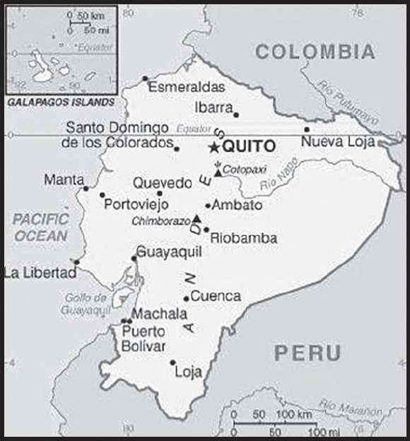
INTRODUCTION
Background: What is now Ecuador formed part of the northern Inca Empire until the Spanish conquest in 1533. Quito became a seat of Spanish colonial government in 1563 and part of the Viceroyalty of New Granada in 1717. The territories of the Viceroyalty - New Granada (Colombia), Venezuela, and Quito - gained their independence between 1819 and 1822 and formed a federation known as Gran Colombia. When Quito withdrew in 1830, the traditional name was changed in favor of the “Republic of the Equator.” Between 1904 and 1942, Ecuador lost territories in a series of conflicts with its neighbors. A border war with Peru that flared in 1995 was resolved in 1999. Although Ecuador marked 30 years of civilian governance in 2004, the period was marred by political instability. Protests in Quito contributed to the mid-term ouster of three of Ecuador’s last four democratically elected presidents. In late 2008, voters approved a new constitution, Ecuador’s 20th since gaining independence. Guillermo LASSO was elected president in April 2021 becoming the country’s first center-right president in nearly two decades when he took office the following month.
GEOGRAPHY
Location: Western South America, bordering the Pacific Ocean at the Equator, between Colombia and Peru
Geographic coordinates: 2 00 S, 77 30 W
Map references: South America
Area: total: 283,561 sq km
land: 276,841 sq km
water: 6,720 sq km
note: includes Galapagos Islands
comparison ranking: total 75
Area - comparative: slightly smaller than Nevada
Land boundaries: total: 2,237 km
border countries (2): Colombia 708 km; Peru 1529 km
Coastline: 2,237 km
Maritime claims: territorial sea: 12 nm
exclusive economic zone: 200 nm
continental shelf: 200 nm
note: Ecuador has declared its right to extend its continental shelf to 350 nm measured from the baselines of the Galapagos Archipelago
Climate: tropical along coast, becoming cooler inland at higher elevations; tropical in Amazonian jungle lowlands
Terrain: coastal plain (costa), inter-Andean central highlands (sierra), and flat to rolling eastern jungle (oriente)
Elevation: highest point: Chimborazo 6,267
lowest point: Pacific Ocean 0 m
mean elevation: 1,117 m
note: because the earth is not a perfect sphere and has an equatorial bulge, the highest point on the planet farthest from its center is Mount Chimborazo not Mount Everest, which is merely the highest peak above sea level
Natural resources: petroleum, fish, timber, hydropower
Land use: agricultural land: 29.7% (2018 est.)
arable land: 4.7% (2018 est.)
permanent crops: 5.6% (2018 est.)
permanent pasture: 19.4% (2018 est.)
forest: 38.9% (2018 est.)
other: 31.4% (2018 est.)
Irrigated land: 10,000 sq km (2020)
Major watersheds (area sq km): Atlantic Ocean drainage: Amazon (6,145,186 sq km)
Population distribution: nearly half of the population is concentrated in the interior in the Andean intermontane basins and valleys, with large concentrations also found along the western coastal strip; the rainforests of the east remain sparsely populated
Natural hazards: frequent earthquakes; landslides; volcanic activity; floods; periodic droughts
volcanism: volcanic activity concentrated along the Andes Mountains; Sangay (5,230 m), which erupted in 2010, is mainland Ecuador’s most active volcano; other historically active volcanoes in the Andes include Antisana, Cayambe, Chacana, Cotopaxi, Guagua Pichincha, Reventador, Sumaco, and Tungurahua; Fernandina (1,476 m), a shield volcano that last erupted in 2009, is the most active of the many Galapagos volcanoes; other historically active Galapagos volcanoes include Wolf, Sierra Negra, Cerro Azul, Pinta, Marchena, and Santiago
Geography - note: note 1: Cotopaxi in Andes is highest active volcano in world
note 2: genetic research indicates that the cherry-sized tomato originated in Ecuador without any human domestication; later domestication in Mexico transformed the plant into the large modern tomato; archeological research indicates that the cacao tree, whose seeds are used to make chocolate and which was long thought to have originated in Mesoamerica, was first domesticated in the upper Amazon region of northwest South America - present-day Ecuador - about 3,300 B.C.
PEOPLE AND SOCIETY
Population: 17,483,326 (2023 est.)
comparison ranking: 70
Nationality: noun: Ecuadorian(s)
adjective: Ecuadorian
Ethnic groups: Mestizo (mixed Amerindian and White) 71.9%, Montubio 7.4%, Amerindian 7%, White 6.1%, Afroecuadorian 4.3%, Mulatto 1.9%, Black 1%, other 0.4% (2010 est.)
Languages: Spanish (Castilian) 93% (official), Quechua 4.1%, other indigenous 0.7%, foreign 2.2%; note - (Quechua and Shuar are official languages of intercultural relations; other indigenous languages are in official use by indigenous peoples in the areas they inhabit) (2010 est.)
major-language sample(s):
La Libreta Informativa del Mundo, la fuente indispensable de información básica. (Spanish)
Religions: Roman Catholic 68.8%, Evangelical 15.4%, Adventist 1.2%, Jehovah’s Witness 1%, other 1.3%, agnostic or atheist 1.4%, none 10.1%, don’t know/no response 1% (2020 est.)
note: data represent persons at least 16 years of age from five Ecuadoran cities
Demographic profile: Ecuador’s high poverty and income inequality most affect indigenous, mixed race, and rural populations. The government has increased its social spending to ameliorate these problems, but critics question the efficiency and implementation of its national development plan. Nevertheless, the conditional cash transfer program, which requires participants’ children to attend school and have medical check-ups, has helped improve educational attainment and health care among poor children. Ecuador’s total fertility rate – the average number of children born per woman – is just below replacement level as of 2023, but its population is continuing to grow.
Ecuador continues to be both a country of emigration and immigration. The first large-scale emigration of largely undocumented Ecuadorians occurred between 1980 and 2000, when an economic crisis drove Ecuadorians from southern provinces to New York City, where they had connections from the earlier Panama hat trade. Emigration from all parts of Ecuador in the late 1990s was caused by another economic downturn, political instability, and a currency crisis. Spain was the logical destination because of its shared language and the wide availability of low-skilled, informal jobs at a time when increased border surveillance made illegal migration to the US difficult. Ecuador became Spain’s second largest immigrant source country. The bulk of Ecuadorian emigration, however, occurred between 2000 and 2007, largely to the US, Spain, and Italy. Emigration has again surged since 2017, as economic problems, high unemployment, poverty, and violence have lead thousands of Ecuadorian migrants and refugees to head to the US. As of 2021, Ecuadorians were the fourth-highest nationality coming into contact with US Customs and Border Protection at the US-Mexico border. Most Ecuadorian migrants and refugees traverse the dangerous Darien Gap between Colombia and Panama to reach Mexico. Although Mexico reinstated a visa requirement in September 2021, Ecuadorians continue to enter Mexico illegally and then travel to the US or Canada. Some wind up staying in Mexico if their journeys north fail. Emigrants represent 8-10% of Ecuador’s population, as of 2021.
Ecuador hosts one of the region’s largest refugee populations. From 2000-2005, Colombians arrived in growing numbers to escape armed conflict, and they have continued to immigrate to Ecuador steadily. Between 2008, when Ecuador lifted visa requirements for all countries, and 2016, immigrants entered from Haiti, Cuba, and other continents. The influx of Venezuelans began in 2017, and, as of May 2022, Ecuador was home to the third-largest community of Venezuelan migrants and refugees in the world at over half a million. Immigrants and refugees account for 3-5% of the Ecuador’s population, as of 2021.
Age structure: 0-14 years: 24.49% (male 2,183,293/female 2,098,856)
15-64 years: 66.44% (male 5,739,156/female 5,876,090)
65 years and over: 9.07% (2023 est.) (male 745,170/female 840,761)
Dependency ratios: total dependency ratio: 50.9
youth dependency ratio: 39.4
elderly dependency ratio: 11.5
potential support ratio: 8.7 (2021 est.)
Median age: total: 28.8 years (2020)
male: 28 years
female: 29.6 years
comparison ranking: total 140
Population growth rate: 1.1% (2023 est.)
comparison ranking: 86
Birth rate: 16.19 births/1,000 population (2023 est.)
comparison ranking: 97
Death rate: 5.18 deaths/1,000 population (2023 est.)
comparison ranking: 189
Net migration rate: 0 migrant(s)/1,000 population (2023 est.)
comparison ranking: 91
Population distribution: nearly half of the population is concentrated in the interior in the Andean intermontane basins and valleys, with large concentrations also found along the western coastal strip; the rainforests of the east remain sparsely populated
Urbanization: urban population: 64.8% of total population (2023)
rate of urbanization: 1.62% annual rate of change (2020-25 est.)
Major urban areas - population: 3.142 million Guayaquil, 1.957 million QUITO (capital) (2023)
Sex ratio: at birth: 1.05 male(s)/female
0-14 years: 1.04 male(s)/female
15-64 years: 0.98 male(s)/female
65 years and over: 0.89 male(s)/female
total population: 0.98 male(s)/female (2023 est.)
Maternal mortality ratio: 66 deaths/100,000 live births (2020 est.)
comparison ranking: 90
Infant mortality rate: total: 17.72 deaths/1,000 live births (2023 est.)
male: 21.22 deaths/1,000 live births
female: 14.04 deaths/1,000 live births
comparison ranking: total 91
Life expectancy at birth: total population: 78.25 years (2023 est.)
male: 75.32 years
female: 81.32 years
comparison ranking: total population 79
Total fertility rate: 2.02 children born/woman (2023 est.)
comparison ranking: 102
Gross reproduction rate: 0.98 (2023 est.)
Contraceptive prevalence rate: 77.9% (2018/19)
note: percent of women aged 15-50
Drinking water source: improved: urban: 100% of population
rural: 87.1% of population
total: 95.4% of population
unimproved: urban: 0% of population
rural: 12.9% of population
total: 4.6% of population (2020 est.)
Current health expenditure: 8.5% of GDP (2020)
Physicians density: 2.22 physicians/1,000 population (2017)
Hospital bed density: 1.4 beds/1,000 population (2016)
Sanitation facility access: improved: urban: 100% of population
rural: 96.9% of population
total: 98.9% of population
unimproved: urban: 0% of population
rural: 3.1% of population
total: 1.1% of population (2020 est.)
Major infectious diseases: degree of risk: high (2023)
food or waterborne diseases: bacterial diarrhea, hepatitis A, and typhoid fever
vectorborne diseases: dengue fever and malaria
Obesity - adult prevalence rate: 19.9% (2016)
comparison ranking: 106
Alcohol consumption per capita: total: 3.05 liters of pure alcohol (2019 est.)
beer: 2.32 liters of pure alcohol (2019 est.)
wine: 0.09 liters of pure alcohol (2019 est.)
spirits: 0.61 liters of pure alcohol (2019 est.)
other alcohols: 0.03 liters of pure alcohol (2019 est.)
comparison ranking: total 114
Tobacco use: total: 11.3% (2020 est.)
male: 18.4% (2020 est.)
female: 4.2% (2020 est.)
comparison ranking: total 128
Children under the age of 5 years underweight: 5.2% (2018/19)
comparison ranking: 73
Currently married women (ages 15-49): 55.1% (2023 est.)
Child marriage: women married by age 15: 3.8%
women married by age 18: 22.2% (2018 est.)
Education expenditures: 3.7% of GDP (2021 est.)
comparison ranking: 128
Literacy: definition: age 15 and over can read and write
total population: 94.5%
male: 94.9%
female: 94% (2021)
School life expectancy (primary to tertiary education): total: 15 years
male: 14 years
female: 15 years (2020)
Youth unemployment rate (ages 15-24): total: 14.2% (2021 est.)
male: 11.4%
female: 18.8%
comparison ranking: total 123
ENVIRONMENT
Environment - current issues: deforestation; soil erosion; desertification; water pollution; pollution from oil production wastes in ecologically sensitive areas of the Amazon Basin and Galapagos Islands
Environment - international agreements: party to: Antarctic-Environmental Protection, Antarctic Treaty, Biodiversity, Climate Change, Climate Change-Kyoto Protocol, Climate Change-Paris Agreement, Comprehensive Nuclear Test Ban, Desertification, Endangered Species, Hazardous Wastes, Law of the Sea, Nuclear Test Ban, Ozone Layer Protection, Ship Pollution, Tropical Timber 2006, Wetlands, Whaling
signed, but not ratified: none of the selected agreements
Climate: tropical along coast, becoming cooler inland at higher elevations; tropical in Amazonian jungle lowlands
Land use: agricultural land: 29.7% (2018 est.)
arable land: 4.7% (2018 est.)
permanent crops: 5.6% (2018 est.)
permanent pasture: 19.4% (2018 est.)
forest: 38.9% (2018 est.)
other: 31.4% (2018 est.)
Urbanization: urban population: 64.8% of total population (2023)
rate of urbanization: 1.62% annual rate of change (2020-25 est.)
Revenue from forest resources: 0.27% of GDP (2018 est.)
comparison ranking: 83
Revenue from coal: 0% of GDP (2018 est.)
comparison ranking: 61
Air pollutants: particulate matter emissions: 16.55 micrograms per cubic meter (2019 est.)
carbon dioxide emissions: 41.15 megatons (2016 est.)
methane emissions: 23.51 megatons (2020 est.)
Waste and recycling: municipal solid waste generated annually: 5,297,211 tons (2015 est.)
municipal solid waste recycled annually: 683,340 tons (2015 est.)
percent of municipal solid waste recycled: 12.9% (2015 est.)
Major watersheds (area sq km): Atlantic Ocean drainage: Amazon (6,145,186 sq km)
Total water withdrawal: municipal: 1.29 billion cubic meters (2020 est.)
industrial: 550 million cubic meters (2020 est.)
agricultural: 8.8 billion cubic meters (2020 est.)
Total renewable water resources: 442.4 billion cubic meters (2020 est.)
GOVERNMENT
Country name: conventional long form: Republic of Ecuador
conventional short form: Ecuador
local long form: República del Ecuador
local short form: Ecuador
etymology: the country’s position on the globe, straddling the Equator, accounts for its Spanish name
Government type: presidential republic
Capital: name: Quito
geographic coordinates: 0 13 S, 78 30 W
time difference: UTC-5 (same time as Washington, DC, during Standard Time)
time zone note: Ecuador has two time zones, including the Galapagos Islands (UTC-6)
etymology: named after the Quitu, a Pre-Columbian indigenous people credited with founding the city; the name is also a combination of two Tsafiki words: quitso (meaning “center” or “half”) + to or tu (“the world”); the combination roughly translates as “center of the world” and reflects the fact that native peoples recognized that at the two annual equinoxes, the overhead sun in that area (only about 20 km (12 mi) north of the equator) did not display any shade and thus must be in the middle of the world
Administrative divisions: 24 provinces (provincias, singular - provincia); Azuay, Bolivar, Canar, Carchi, Chimborazo, Cotopaxi, El Oro, Esmeraldas, Galapagos, Guayas, Imbabura, Loja, Los Rios, Manabi, Morona Santiago, Napo, Orellana, Pastaza, Pichincha, Santa Elena, Santo Domingo de los Tsachilas, Sucumbios, Tungurahua, Zamora Chinchipe
Independence: 24 May 1822 (from Spain)
National holiday: Independence Day (independence of Quito), 10 August (1809)
Constitution: history: many previous; latest approved 20 October 2008
amendments: proposed by the president of the republic through a referendum, by public petition of at least 1% of registered voters, or by agreement of at least one-third membership of the National Assembly; passage requires two separate readings a year apart and approval by at least two-thirds majority vote of the Assembly, and approval by absolute majority in a referendum; amendments such as changes to the structure of the state, constraints on personal rights and guarantees, or constitutional amendment procedures are not allowed; amended 2011, 2015, 2018
Legal system: civil law based on the Chilean civil code with modifications; traditional law in indigenous communities
International law organization participation: has not submitted an ICJ jurisdiction declaration; accepts ICCt jurisdiction
Citizenship: citizenship by birth: yes
citizenship by descent only: yes
dual citizenship recognized: no
residency requirement for naturalization: 3 years
Suffrage: 18-65 years of age; universal and compulsory; 16-18, over 65, and other eligible voters, voluntary
Executive branch: chief of state: President Guillermo LASSO Mendoza (since 24 May 2021); Vice President Alfredo Enrique BORRERO Vega (since 24 May 2021); the president is both chief of state and head of government
head of government: President Guillermo LASSO Mendoza (since 24 May 2021); Vice President Alfredo Enrique BORRERO Vega (since 24 May 2021)
cabinet: Cabinet appointed by the president
elections/appointments: president and vice president directly elected on the same ballot by absolute majority popular vote in 2 rounds if needed for a 4-year term (eligible for a second term); election last held on 20 August 2023 with a runoff on 15 October 2023 (next to be held on 28 February 2025); note – on 18 May 2023, Ecuador’s National Electoral Council announced that the legislative and presidential elections — originally scheduled for February 2025—would be held on 20 August 2023 (with a runoff election held 15 October 2023) after President Guillermo LASSO dissolved the National Assembly by decree on 17 May 2023; though eligible for a second term, LASSO announced that he would not run in the 2023 election; the next president will serve out the remainder of the current presidential term (2021–2025)
election results:
2023: first round results: percent of vote - Luisa GONZÁLEZ Alcivar (MRC) 33.6%, Daniel NOBOA Azin (ADN) 23.5%, Christian Gustavo ZURITA Ron (Construye) 16.4%, Jan Tomislav TOPIĆ Feraud (Por Un País Sin Miedo) 14.7%, Otto Ramón SONNENHOLZNER Sper (Avanza) 7.1% other 4.7%; second round results: percent of vote - Daniel NOBOA Azin (ADN) 51.8%, Luisa GONZÁLEZ Alcivar (MRC) 48.2%; note - NOBOA is scheduled to take office 25 November 2023
2021: Guillermo LASSO Mendoza elected president; first round election results: percent of vote - Andres ARAUZ (UNES) 32.72%, Guillermo LASSO Mendoza (CREO) 19.74%, Yaku PEREZ Guartambel (MUPP) 19.38%, Xavier HERVAS Mora (ID) 15.68%, other 12.48%; second round election results: percent of vote - Guillermo LASSO Mendoza (CREO) 52.5%, Andres ARAUZ (UNES) 47.5%
Legislative branch: description: unicameral National Assembly or Asamblea Nacional (137 seats; 116 members directly elected in single-seat constituencies by simple majority vote, 15 members directly elected in a single nationwide constituency by open-list proportional representation vote, and 6 directly elected in multi-seat constituencies for Ecuadorians living abroad by simple majority vote; members serve 4-year terms); note - all Assembly members have alternates from the same party who cast votes when a primary member is absent, resigns, or is removed from office
elections: last held on 20 August 2023 (next to be held on 28 February 2025); note – on 18 May 2023, Ecuador’s National Electoral Council announced that the legislative and presidential elections—originally scheduled for February 2025—would be held on 20 August 2023 after President Guillermo LASSO dissolved the National Assembly by decree on 17 May 2023; a return to a regular election cycle will occur in February 2025
election results: percent of vote by party - MRC 39.7%, Construye 20.4%, ADN 14.6%, PSC 11.9%, Actuemos 4.5%, PSP 3.2%, other 5.7%; seats by party - NA; note - defections by National Assembly members are commonplace, resulting in frequent changes in the numbers of seats held by the various parties
Judicial branch: highest court(s): National Court of Justice or Corte Nacional de Justicia (consists of 21 judges, including the chief justice and organized into 5 specialized chambers); Constitutional Court or Corte Constitucional (consists of the court president and 8 judges)
judge selection and term of office: candidates for the National Court of Justice evaluated and appointed justices by the Judicial Council, a 9-member independent body of law professionals; justices elected for 9-year, non-renewable terms, with one-third of the membership renewed every 3 years; candidates for the Constitutional Court evaluated and appointed judges by a 6-member independent body of law professionals; judges appointed for 4-year renewable terms
subordinate courts: provincial courts (one for each province except Galapagos); fiscal, criminal, and administrative tribunals; Election Dispute Settlement Courts; cantonal courts
Political parties and leaders: Actuemos Ecuador or Actuemos
Avanza Party or AVANZA [Javier ORTI Torres]
Central Democratic Movement or CD [Jimmy JAIRALA]
Citizen Revolution Movement or MRC or RC5 [Marcela AGUIÑAGA]
Creating Opportunities Movement or CREO [Guido CHIRIBOGA]
Democratic Left or ID [Enrique CHÁVEZ]
For A Country Without Fear (Por Un País Sin Miedo)
Movimiento Construye or Construye
National Democratic Action (Acción Democrática Nacional) or ADN [Daniel NOBOA]
Pachakutik Plurinational Unity Movement or MUPP [Guillermo CHURUCHUMBI]
Patriotic Society Party or PSP [Lucio GUTIERREZ Borbua]
Social Christian Party or PSC [Alfredo SERRANO]
Socialist Party [Gustavo VALLEJO]
Society United for More Action or SUMA [Guillermo CELI]
International organization participation: CAN, CD, CELAC, FAO, G-11, G-77, IADB, IAEA, IBRD, ICAO, ICC (national committees), ICCt, ICRM, IDA, IFAD, IFC, IFRCS, IHO, ILO, IMF, IMO, Interpol, IOC, IOM, IPU, ISO, ITSO, ITU, ITUC (NGOs), LAES, LAIA, Mercosur (associate), MIGA, MINUSTAH, NAM, OAS, OPANAL, OPCW, OPEC, Pacific Alliance (observer), PCA, PROSUR, SICA (observer), UN, UNCTAD, UNESCO, UNHCR, UNIDO, Union Latina, UNISFA, UNMIL, UNMISS, UNOCI, UNWTO, UPU, WCO, WFTU (NGOs), WHO, WIPO, WMO, WTO
Diplomatic representation in the US: chief of mission: Ambassador Ivonne Leila Juez De A-BAKI (since 6 February 2020)
chancery: 2535 15th Street NW, Washington, DC 20009
telephone: [1] (202) 234-7200
FAX: [1] (202) 333-2893
email address and website:
consulate(s) general: Atlanta, Chicago, Houston, Los Angeles, Miami, Minneapolis, New Haven (CT), New York, Newark (NJ), Phoenix, San Francisco
Diplomatic representation from the US: chief of mission: Ambassador Michael J. FITZPATRICK (since 3 July 2019)
embassy: E12-170 Avenida Avigiras y Avenida Eloy Alfaro, Quito
mailing address: 3420 Quito Place, Washington DC 20521-3420
telephone: [593] (2) 398-5000
email address and website:
consulate(s) general: Guayaquil
Flag description: three horizontal bands of yellow (top, double width), blue, and red with the coat of arms superimposed at the center of the flag; the flag retains the three main colors of the banner of Gran Colombia, the South American republic that broke up in 1830; the yellow color represents sunshine, grain, and mineral wealth, blue the sky, sea, and rivers, and red the blood of patriots spilled in the struggle for freedom and justice
note: similar to the flag of Colombia, which is shorter and does not bear a coat of arms
National symbol(s): Andean condor; national colors: yellow, blue, red
National anthem: name: “Salve, Oh Patria!” (We Salute You, Our Homeland)
lyrics/music: Juan Leon MERA/Antonio NEUMANE
note: adopted 1948; Juan Leon MERA wrote the lyrics in 1865; only the chorus and second verse are sung
National heritage: total World Heritage Sites: 5 (3 cultural, 2 natural)
selected World Heritage Site locales: Historic Quito (c); Galápagos Islands (n); Historic Cuenca (c); Qhapaq Ñan/Andean Road System (c); Sangay National Park (n)
ECONOMY
Economic overview: highly informal South American economy; USD currency user; major banana exporter; hard hit by COVID-19; macroeconomic fragility from oil dependency; successful debt restructuring; China funding budget deficits; social unrest hampering economic activity
Real GDP (purchasing power parity): $189.88 billion (2021 est.)
$182.165 billion (2020 est.)
$197.549 billion (2019 est.)
note: data are in 2017 dollars
comparison ranking: 69
Real GDP growth rate: 4.24% (2021 est.)
-7.79% (2020 est.)
0.01% (2019 est.)
comparison ranking: 112
Real GDP per capita: $10,700 (2021 est.)
$10,400 (2020 est.)
$11,400 (2019 est.)
note: data are in 2017 dollars
comparison ranking: 141
GDP (official exchange rate)
$107.436 billion (2019 est.)
Inflation rate (consumer prices) 0.13% (2021 est.)
-0.34% (2020 est.)
0.27% (2019 est.)
comparison ranking: 213
Credit ratings: Fitch rating: B- (2020)
Moody’s rating: Caa3 (2020)
Standard & Poors rating: B- (2020)
note: The year refers to the year in which the current credit rating was first obtained.
GDP - composition, by sector of origin
agriculture: 6.7% (2017 est.)
industry: 32.9% (2017 est.)
services: 60.4% (2017 est.)
comparison rankings: services 121; industry 60; agriculture 115
GDP - composition, by end use
household consumption: 60.7% (2017 est.)
government consumption: 14.4% (2017 est.)
investment in fixed capital: 24.3% (2017 est.)
investment in inventories: 1% (2017 est.)
exports of goods and services: 20.8% (2017 est.)
imports of goods and services: -21.3% (2017 est.)
Agricultural products: sugar cane, bananas, milk, oil palm fruit, maize, rice, plantains, poultry, cocoa, potatoes
Industries: petroleum, food processing, textiles, wood products, chemicals
Industrial production growth rate: 0.49% (2021 est.)
note: excludes oil refining
comparison ranking: 154
Labor force: 8.528 million (2021 est.)
comparison ranking: 62
Labor force - by occupation: agriculture: 26.1%
industry: 18.4%
services: 55.5% (2017 est.)
Unemployment rate: 6.43% (2021 est.)
6.11% (2020 est.)
3.81% (2019 est.)
comparison ranking: 121
Youth unemployment rate (ages 15-24): total: 14.2% (2021 est.)
male: 11.4%
female: 18.8%
comparison ranking: total 123
Population below poverty line: 25% (2019 est.)
Gini Index coefficient - distribution of family income: 47.3 (2020 est.)
note: data are for urban households only
comparison ranking: 20
Average household expenditures: on food: 26.2% of household expenditures (2018 est.)
on alcohol and tobacco: 0.8% of household expenditures (2018 est.)
Household income or consumption by percentage share: lowest 10%: 1.4%
highest 10%: 35.4% (2012 est.)
note: data are for urban households only
Budget: revenues: $35.914 billion (2019 est.)
expenditures: $39.319 billion (2019 est.)
Budget surplus (+) or deficit (-): -4.5% (of GDP) (2017 est.)
comparison ranking: 164
Public debt: 45.4% of GDP (2017 est.)
43.2% of GDP (2016 est.)
comparison ranking: 123
Taxes and other revenues: 12.54% (of GDP) (2020 est.)
comparison ranking: 172
Fiscal year: calendar year
Current account balance: $2.952 billion (2021 est.)
$2.69 billion (2020 est.)
-$59.36 million (2019 est.)
comparison ranking: 37
Exports: $29.325 billion (2021 est.) note: data are in current year dollars
$22.401 billion (2020 est.) note: data are in current year dollars
$26.12 billion (2019 est.) note: data are in current year dollars
comparison ranking: 74
Exports - partners: United States 30%, China 13%, Panama 8%, Chile 7% (2019)
Exports - commodities: crude petroleum, shrimp, bananas, refined petroleum, tuna (2021)
Imports: $28.567 billion (2021 est.) note: data are in current year dollars
$19.877 billion (2020 est.) note: data are in current year dollars
$25.89 billion (2019 est.) note: data are in current year dollars
comparison ranking: 74
Imports - partners: United States 22%, China 18%, Colombia 9%, Panama 5% (2019)
Imports - commodities: refined petroleum, coal tar oil, cars, packaged medicines, soybean products (2019)
Reserves of foreign exchange and gold: $7.912 billion (31 December 2021 est.)
$7.137 billion (31 December 2020 est.)
$2.939 billion (31 December 2019 est.)
comparison ranking: 92
Debt - external: $50.667 billion (2019 est.)
$43.224 billion (2018 est.)
comparison ranking: 67
Exchange rates: 1 (2021 est.)
1 (2020 est.)
1 (2019 est.)
1 (2018 est.)
1 (2017 est.)
the US dollar became Ecuador’s currency in 2001
ENERGY
Electricity access: electrification - total population: 100% (2021)
Electricity: installed generating capacity: 9.354 million kW (2020 est.)
consumption: 26,353,430,000 kWh (2019 est.)
exports: 1.826 billion kWh (2019 est.)
imports: 6 million kWh (2019 est.)
transmission/distribution losses: 4.303 billion kWh (2019 est.)
comparison rankings: installed generating capacity 67; transmission/distribution losses 52; imports 118; exports 53; consumption 68
Electricity generation sources: fossil fuels: 21% of total installed capacity (2020 est.)
solar: 0.1% of total installed capacity (2020 est.)
wind: 0.2% of total installed capacity (2020 est.)
hydroelectricity: 77.2% of total installed capacity (2020 est.)
biomass and waste: 1.5% of total installed capacity (2020 est.)
Coal: production: 0 metric tons (2020 est.)
consumption: 10,000 metric tons (2020 est.)
exports: 0 metric tons (2020 est.)
imports: 10,000 metric tons (2020 est.)
proven reserves: 24 million metric tons (2019 est.)
Petroleum: total petroleum production: 478,000 bbl/day (2021 est.)
refined petroleum consumption: 259,000 bbl/day (2019 est.)
crude oil and lease condensate exports: 349,400 bbl/day (2018 est.)
crude oil and lease condensate imports: 0 bbl/day (2018 est.)
crude oil estimated reserves: 8.273 billion barrels (2021 est.)
Refined petroleum products - production: 137,400 bbl/day (2015 est.)
comparison ranking: 62
Refined petroleum products - exports: 25,870 bbl/day (2015 est.)
comparison ranking: 66
Refined petroleum products - imports: 153,900 bbl/day (2015 est.)
comparison ranking: 40
Natural gas: production: 342.407 million cubic meters (2019 est.)
consumption: 342.407 million cubic meters (2019 est.)
exports: 0 cubic meters (2021 est.)
imports: 0 cubic meters (2021 est.)
proven reserves: 10.902 billion cubic meters (2021 est.)
Carbon dioxide emissions: 36.051 million metric tonnes of CO2 (2019 est.)
from coal and metallurgical coke: 45,000 metric tonnes of CO2 (2019 est.)
from petroleum and other liquids: 35.329 million metric tonnes of CO2 (2019 est.)
from consumed natural gas: 677,000 metric tonnes of CO2 (2019 est.)
comparison ranking: total emissions 70
Energy consumption per capita: 42.564 million Btu/person (2019 est.)
comparison ranking: 104
COMMUNICATIONS
Telephones - fixed lines: total subscriptions: 1,846,666 (2021)
subscriptions per 100 inhabitants: 10 (2021 est.)
comparison ranking: total subscriptions 56
Telephones - mobile cellular: total subscriptions: 16,789,600 (2021 est.)
subscriptions per 100 inhabitants: 94 (2021 est.)
comparison ranking: total subscriptions 66
Telecommunication systems: general assessment: Ecuador has a small telecom market dominated by the mobile sector; the evolution of the market has been influenced by the poor fixed-line infrastructure, which has stymied the development of fixed-line broadband services; to some extent poor infrastructure has been the result of topographical challenges which have rendered the cost of deploying networks to remote and mountainous areas prohibitive; although Ecuador has several fixed-line operators and a large number of ISPs, the state-owned incumbent leads the fixed-line market, and thus also the fixed broadband market; thus far the MVNO sector has been slow to develop, partly because the incumbent operators also have their low-cost brands and thus there is little business case for new market entrants; the government is keen to advance and improve teledensity; from 2022, additional revenue will be earmarked for programs aimed at expanding the reach of internet and mobile services in rural areas of the country; Ecuador lacks a national 5G roadmap; the mobile operators have conducted several 5G pilots, but no progress has been made on allocation spectrum for 5G, or on developing strategies to encourage investment in the sector (2022)
domestic: according to 2021 statistics from the Ministry of Telecommunications and Information Society, 50 percent of Ecuadorian homes do not have access to fixed internet; fixed-line teledensity is about 10 per 100 persons; mobile-cellular service with a subscribership of nearly 94 per 100 persons (2021)
international: country code - 593; landing points for the SPSC (Mistral Submarine Cable), Panamerican Cable System (PAN-AM), Pacific Caribbean Cable System (PCCS), America Movil-Telxius West Coast Cable and SAm-1 submarine (SAm-1) cables that provide links to South and Central America, and extending onward to the Caribbean and the US; satellite earth station - 1 Intelsat (Atlantic Ocean) (2019)
Broadcast media: the Communication Council, an official entity, carried out a media registry in Ecuador in December 2020. It registered 956 media outlets, 89% are private, 5% are public and 6% belong to small communities. The government controls most of the 44 public media, this includes national media and multiple local radio stations. In addition, of the 956 registered media, 58% are radio and 18% print. Two provinces have the largest number of media outlets: Guayas has 172 media outlets and Pichincha has 130 media outlets. (2020) so also sent to the National Assembly a new regulation proposal that is still under discussion.
(2022)
Internet country code: .ec
Internet users: total: 13.68 million (2021 est.)
percent of population: 76% (2021 est.)
according to 2021 statistics from Ecuador’s Ministry of Telecommunications and Information Society, 50% of homes do not have access to fixed internet
comparison ranking: total 51
Broadband - fixed subscriptions: total: 2,371,297 (2020 est.)
subscriptions per 100 inhabitants: 13 (2020 est.)
comparison ranking: total 55
TRANSPORTATION
National air transport system: number of registered air carriers: 7 (2020)
inventory of registered aircraft operated by air carriers: 35
annual passenger traffic on registered air carriers: 5,365,261 (2018)
annual freight traffic on registered air carriers: 64.2 million (2018) mt-km
Civil aircraft registration country code prefix: HC
Airports: 432 (2021)
comparison ranking: total 18
Airports - with paved runways: 104
note: paved runways have a concrete or asphalt surface but not all have facilities for refueling, maintenance, or air traffic control; the length of a runway required for aircraft to safely operate depends on a number of factors including the type of aircraft, the takeoff weight (including passengers, cargo, and fuel), engine types, flap settings, landing speed, elevation of the airport, and average maximum daily air temperature; paved runways can reach a length of 5,000 m (16,000 ft.), but the “typical” length of a commercial airline runway is between 2,500-4,000 m (8,000-13,000 ft.)
Airports - with unpaved runways: 328
note: unpaved runways have a surface composition such as grass or packed earth and are most suited to the operation of light aircraft; unpaved runways are usually short, often less than 1,000 m (3,280 ft.) in length; airports with unpaved runways often lack facilities for refueling, maintenance, or air traffic control
Heliports: 2 (2021)
Pipelines: 485 km extra heavy crude, 123 km gas, 2,131 km oil, 1,526 km refined products (2017)
Railways: total: 965 km (2022)
narrow gauge: 965 km (2022) 1.067-m gauge
note: passenger service limited to certain sections of track, mostly for tourist trains
comparison ranking: total 90
Roadways: total: 43,950 km (2022)
paved: 8,895 km (2022)
unpaved: 35,055 km (2022)
comparison ranking: total 86
Waterways: 1,500 km (2012) (most inaccessible)
comparison ranking: 55
Merchant marine: total: 147 (2022)
by type: container ship 1, general cargo 8, oil tanker 28, other 110
comparison ranking: total 76
Ports and terminals: major seaport(s): Esmeraldas, Manta, Puerto Bolivar
container port(s) (TEUs): Guayaquil (2,163,151) (2021)
river port(s): Guayaquil (Guayas)
MILITARY AND SECURITY
Military and security forces: Ecuadorian Armed Forces: the Ecuadorian Army (Ejército Ecuatoriano), Ecuadorian Navy (Armada del Ecuador, Fuerza Naval del Ecuador, FNE; includes naval infantry, naval aviation, coast guard), Ecuadorian Air Force (Fuerza Aerea Ecuatoriana, FAE) (2023)
note: the National Police of Ecuador (Policía Nacional del Ecuador) is under the Ministry of Government/Interior
Military expenditures: 2% of GDP (2022 est.)
2% of GDP (2021 est.)
2.3% of GDP (2020 est.)
2.2% of GDP (2019)
2.4% of GDP (2018)
comparison ranking: 62
Military and security service personnel strengths: approximately 40,000 active military personnel (25,000 Army; 9,000 Navy; 6,000 Air Force) (2023)
Military equipment inventories and acquisitions: the military’s inventory includes a wide mix of mostly older equipment derived from a variety of sources such as Brazil, China, Russia, and the US; in recent years, Ecuador has received limited amounts of more modern material from several countries, including Germany and Spain (2023)
Military service age and obligation: 18-22 years of age for selective conscript military service for men, although conscription was suspended in 2008; 18 years of age for voluntary military service for men and women; 12-month service obligation (2023)
note: in 2022, women made up an estimated 3-4% of the military
Military - note: the military is responsible for preserving Ecuador’s national sovereignty and defending the integrity of the state; it also has some domestic security responsibilities and may complement police operations in maintaining public order if required; the military shares responsibility for border enforcement with the National Police; it trains regularly, participates in bilateral and multinational training exercises, and sends troops on UN peacekeeping missions; the military has defense ties to regional countries, such as Chile, Colombia, and Peru, and security ties with the US have been revived in recent years
border conflicts with Peru dominated the military’s focus until the late 1990s and border security remains a priority, but in more recent years, security challenges have included counterinsurgency and counternarcotics operations, particularly in the northern border area where violence and other criminal activity related to terrorism, insurgency, and narco-trafficking in Colombia, as well as refugees from Venezuela, have spilled over the border; the military has established a joint service task force for counterinsurgency and counternarcotics operations and boosted troop deployments along those borders; other missions include countering illegal mining, smuggling, and maritime piracy; since 2012, the Ecuadorian Government has expanded the military’s role in general public security and domestic crime operations, in part due to rising violence, police corruption, and police ineffectiveness
the Joint Command of the Armed Forces (El Comando Conjunto de las Fuerzas Armadas or CCFFAA) is the military’s highest body for planning, preparation, and strategic conduct of military operations; the chief of the CCFFAA is appointed by the president; the military is deployed throughout the country in five joint service operational commands or task forces; it also has a cyber defense command; the Army is organized into four regionally based divisions and approximately 12 combat brigades, including armored cavalry, artillery, aviation, infantry (including specialized jungle infantry), and special forces; the Navy is a compact force comprised of two frigates, six corvettes, three missile attack boats, and two attack submarines; it also has a small aviation force and a Marine Corps with about 2,000 amphibious infantry and commandos; the Air Force has small numbers of operational jet fighters and light ground attack aircraft, as well as some multirole helicopters
the military has had a large role in Ecuador’s political history; it ruled the country from 1963-1966 and 1972-1979, and supported a dictatorship in 1970-1972; during the 1980s, the military remained loyal to the civilian government, but civilian-military relations were at times tenuous, and the military had considerable autonomy from civilian oversight; it was involved in coup attempts in 2000 and 2010 (2023)
SPACE
Space agency/agencies: Ecuadorian Civilian Space Agency (EXA; a private research and development institution in charge of the administration and execution of Ecuador’s space program, established 2007); Ecuadorian Space Institute (established 2012, disbanded 2018) (2023)
Space program overview: has a small program focused on acquiring or manufacturing satellites; builds scientific satellites; conducts research and develops some space-related technologies; has established relations with the space agencies and industries of China and Russia, as well as the Latin American and Caribbean Space Agency (ALCE) and its member states (2023)
note: further details about the key activities, programs, and milestones of the country’s space program, as well as government spending estimates on the space sector, appear in Appendix S
TRANSNATIONAL ISSUES
Disputes - international: organized illegal narcotics operations in Colombia penetrate across Ecuador’s shared border
Refugees and internally displaced persons: refugees (country of origin): 65,854 (Colombia) (refugees and asylum seekers) (2021); 513,900 (Venezuela) (economic and political crisis; includes Venezuelans who have claimed asylum, are recognized as refugees, or have received alternative legal stay) (2022)
Illicit drugs: Ecuador is a major transit country for cocaine destined for the United States and other international destinations; criminal groups traffic cocaine precursor chemicals for drug gangs; not a major drug producing country; a major source of precursor or essential chemicals used in the production of illicit narcotics
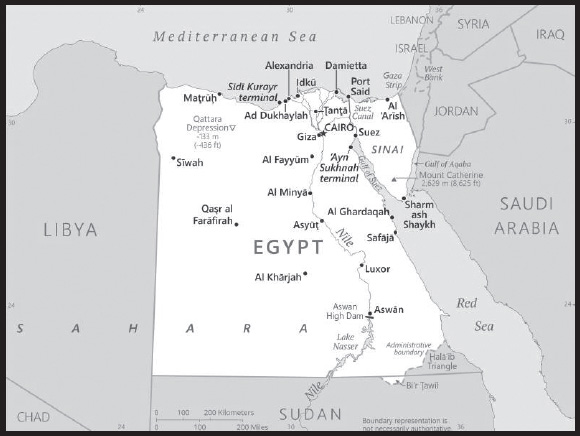
INTRODUCTION
Background: The regularity and richness of the annual Nile River flood, coupled with semi-isolation provided by deserts to the east and west, allowed for the development of one of the world’s great civilizations. A unified kingdom arose circa 3200 B.C., and a series of dynasties ruled in Egypt for the next three millennia. The last native dynasty fell to the Persians in 341 B.C., who in turn were replaced by the Greeks, Romans, and Byzantines. Arab conquerors introduced Islam and the Arabic language in the 7th century and ruled for the next six centuries. A local military caste, the Mamluks took control about 1250 and continued to govern after the conquest of Egypt by the Ottoman Turks in 1517. Completion of the Suez Canal in 1869 elevated Egypt as an important world transportation hub. Ostensibly to protect its investments, Britain seized control of Egypt’s government in 1882, but nominal allegiance to the Ottoman Empire continued until 1914. Egypt gained partial independence from the UK in 1922 and acquired full sovereignty from Britain in 1952. British forces evacuated the Suez Canal Zone in 1956. The completion of the Aswan High Dam in 1971 and the resultant Lake Nasser have reaffirmed the time-honored place of the Nile River in the agriculture and ecology of Egypt. A rapidly growing population (the largest in the Arab world), limited arable land, and dependence on the Nile all continue to overtax resources and stress society. The government has struggled to meet the demands of Egypt’s fast-growing population as it implements large-scale infrastructure projects, energy cooperation, and foreign direct investment appeals.
Inspired by the 2010 Tunisian revolution, Egyptian opposition groups led demonstrations and labor strikes countrywide, culminating in President Hosni MUBARAK’s ouster in 2011. Egypt’s military assumed national leadership until a new legislature was in place in early 2012; later that same year, Muslim Brotherhood candidate Muhammad MURSI won the presidential election. Following protests throughout the spring of 2013 against MURSI’s government and the Muslim Brotherhood, the Egyptian Armed Forces intervened and removed MURSI from power in July 2013 and replaced him with interim president Adly MANSOUR. Simultaneously, the government began enacting laws to limit freedoms of assembly and expression. In January 2014, voters approved a new constitution by referendum and in May 2014 elected former defense minister Abdelfattah ELSISI president. Egypt elected a new legislature in December 2015, its first House of Representatives since 2012. ELSISI was reelected to a second four-year term in March 2018. In April 2019, Egypt approved via national referendum a set of constitutional amendments extending ELSISI’s term in office through 2024 and possibly through 2030 if reelected for a third term. The amendments would also allow future presidents up to two consecutive six-year terms in office, reestablish an upper legislative house, allow for one or more vice presidents, establish a 25% quota for female legislators, reaffirm the military’s role as guardian of Egypt, and expand presidential authority to appoint the heads of judicial councils. Successful legislative elections were held in October-November 2020, having been delayed for six months.
GEOGRAPHY
Location: Northern Africa, bordering the Mediterranean Sea, between Libya and the Gaza Strip, and the Red Sea north of Sudan, and includes the Asian Sinai Peninsula
Geographic coordinates: 27 00 N, 30 00 E
Map references: Africa
Area: total: 1,001,450 sq km
land: 995,450 sq km
water: 6,000 sq km
comparison ranking: total 31
Area - comparative: more than eight times the size of Ohio; slightly more than three times the size of New Mexico
Land boundaries: total: 2,612 km
border countries (4): Gaza Strip 13 km; Israel 208 km; Libya 1,115 km; Sudan 1,276 km
Coastline: 2,450 km
Maritime claims: territorial sea: 12 nm
contiguous zone: 24 nm
exclusive economic zone: 200 nm or the equidistant median line with Cyprus
continental shelf: 200 nm
Climate: desert; hot, dry summers with moderate winters
Terrain: vast desert plateau interrupted by Nile valley and delta
Elevation: highest point: Mount Catherine 2,629 m
lowest point: Qattara Depression -133 m
mean elevation: 321 m
Natural resources: petroleum, natural gas, iron ore, phosphates, manganese, limestone, gypsum, talc, asbestos, lead, rare earth elements, zinc
Land use: agricultural land: 3.6% (2018 est.)
arable land: 2.8% (2018 est.)
permanent crops: 0.8% (2018 est.)
permanent pasture: 0% (2018 est.)
forest: 0.1% (2018 est.)
other: 96.3% (2018 est.)
Irrigated land: 36,500 sq km (2012)
Major lakes (area sq km): salt water lake(s): Lake Manzala - 1,360 sq km
note - largest of Nile Delta lakes
Major rivers (by length in km): An Nīl (Nile) river mouth (shared with Rwanda [s], Tanzania, Uganda, South Sudan, and Sudan) - 6,650 km
note – [s] after country name indicates river source; [m] after country name indicates river mouth
Major watersheds (area sq km): Atlantic Ocean drainage: (Mediterranean Sea) Nile (3,254,853 sq km)
Major aquifers: Nubian Aquifer System
Population distribution: approximately 95% of the population lives within 20 km of the Nile River and its delta; vast areas of the country remain sparsely populated or uninhabited as shown in this population distribution map
Natural hazards: periodic droughts; frequent earthquakes; flash floods; landslides; hot, driving windstorms called khamsin occur in spring; dust storms; sandstorms
Geography - note: note: controls Sinai Peninsula, the only land bridge between Africa and remainder of Eastern Hemisphere; controls Suez Canal, a sea link between Indian Ocean and Mediterranean Sea; size, and juxtaposition to Israel, establish its major role in Middle Eastern geopolitics; dependence on upstream neighbors; dominance of Nile basin issues; prone to influxes of refugees from Sudan and the Palestinian territories
PEOPLE AND SOCIETY
Population: 109,546,720 (2023 est.)
comparison ranking: 15
Nationality: noun: Egyptian(s)
adjective: Egyptian
Ethnic groups: Egyptian 99.7%, other 0.3% (2006 est.)
note: data represent respondents by nationality
Languages: Arabic (official), English, and French widely understood by educated classes
major-language sample(s):

(Arabic)
Religions: Muslim (predominantly Sunni) 90%, Christian (majority Coptic Orthodox, other Christians include Armenian Apostolic, Catholic, Maronite, Orthodox, and Anglican) 10%
Demographic profile: Egypt is the most populous country in the Arab world and the third-most-populous country in Africa, behind Nigeria and Ethiopia. Most of the country is desert, so about 95% of the population is concentrated in a narrow strip of fertile land along the Nile River, which represents only about 5% of Egypt’s land area. Egypt’s rapid population growth – 46% between 1994 and 2014 – stresses limited natural resources, jobs, housing, sanitation, education, and health care.
Although the country’s total fertility rate (TFR) fell from roughly 5.5 children per woman in 1980 to just over 3 in the late 1990s, largely as a result of state-sponsored family planning programs, the population growth rate dropped more modestly because of decreased mortality rates and longer life expectancies. During the last decade, Egypt’s TFR decline stalled for several years and then reversed, reaching 3.6 in 2011, and is under 3 as of 2022. Contraceptive use has held steady at about 60%, while preferences for larger families and early marriage may have strengthened in the wake of the recent 2011 revolution. The large cohort of women of or nearing childbearing age will sustain high population growth for the foreseeable future (an effect called population momentum).
Nevertheless, post-MUBARAK governments have not made curbing population growth a priority. To increase contraceptive use and to prevent further overpopulation will require greater government commitment and substantial social change, including encouraging smaller families and better educating and empowering women. Currently, literacy, educational attainment, and labor force participation rates are much lower for women than men. In addition, the prevalence of violence against women, the lack of female political representation, and the perpetuation of the nearly universal practice of female genital cutting continue to keep women from playing a more significant role in Egypt’s public sphere.
Population pressure, poverty, high unemployment, and the fragmentation of inherited land holdings have historically motivated Egyptians, primarily young men, to migrate internally from rural and smaller urban areas in the Nile Delta region and the poorer rural south to Cairo, Alexandria, and other urban centers in the north, while a much smaller number migrated to the Red Sea and Sinai areas. Waves of forced internal migration also resulted from the 1967 Arab-Israeli War and the floods caused by the completion of the Aswan High Dam in 1970. Limited numbers of students and professionals emigrated temporarily prior to the early 1970s, when economic problems and high unemployment pushed the Egyptian Government to lift restrictions on labor migration. At the same time, high oil revenues enabled Saudi Arabia, Iraq, and other Gulf states, as well as Libya and Jordan, to fund development projects, creating a demand for unskilled labor (mainly in construction), which attracted tens of thousands of young Egyptian men.
Between 1970 and 1974 alone, Egyptian migrants in the Gulf countries increased from approximately 70,000 to 370,000. Egyptian officials encouraged legal labor migration both to alleviate unemployment and to generate remittance income (remittances continue to be one of Egypt’s largest sources of foreign currency and GDP). During the mid-1980s, however, depressed oil prices resulting from the Iran-Iraq War, decreased demand for low-skilled labor, competition from less costly South Asian workers, and efforts to replace foreign workers with locals significantly reduced Egyptian migration to the Gulf States. The number of Egyptian migrants dropped from a peak of almost 3.3 million in 1983 to about 2.2 million at the start of the 1990s, but numbers gradually recovered.
In the 2000s, Egypt began facilitating more labor migration through bilateral agreements, notably with Arab countries and Italy, but illegal migration to Europe through overstayed visas or maritime human smuggling via Libya also rose. The Egyptian Government estimated there were 6.5 million Egyptian migrants in 2009, with roughly 75% being temporary migrants in other Arab countries (Libya, Saudi Arabia, Jordan, Kuwait, and the United Arab Emirates) and 25% being predominantly permanent migrants in the West (US, UK, Italy, France, and Canada).
During the 2000s, Egypt became an increasingly important transit and destination country for economic migrants and asylum seekers, including Palestinians, East Africans, and South Asians and, more recently, Iraqis and Syrians. Egypt draws many refugees because of its resettlement programs with the West; Cairo has one of the largest urban refugee populations in the world. Many East African migrants are interned or live in temporary encampments along the Egypt-Israel border, and some have been shot and killed by Egyptian border guards.
Age structure: 0-14 years: 34.37% (male 19,381,371/female 18,271,080)
15-64 years: 60.27% (male 33,921,778/female 32,102,087)
65 years and over: 5.36% (2023 est.) (male 2,976,765/female 2,893,639)
Dependency ratios: total dependency ratio: 60.8
youth dependency ratio: 53.2
elderly dependency ratio: 7.7
potential support ratio: 13 (2021 est.)
Median age: total: 24.1 years (2020)
male: 23.8 years
female: 24.5 years
comparison ranking: total 168
Population growth rate: 1.59% (2023 est.)
comparison ranking: 58
Birth rate: 20.48 births/1,000 population (2023 est.)
comparison ranking: 66
Death rate: 4.32 deaths/1,000 population (2023 est.)
comparison ranking: 208
Net migration rate: -0.29 migrant(s)/1,000 population (2023 est.)
comparison ranking: 119
Population distribution: approximately 95% of the population lives within 20 km of the Nile River and its delta; vast areas of the country remain sparsely populated or uninhabited as shown in this population distribution map
Urbanization: urban population: 43.1% of total population (2023)
rate of urbanization: 1.9% annual rate of change (2020-25 est.)
Major urban areas - population: 22.183 million CAIRO (capital), 5.588 million Alexandria, 778,000 Bur Sa’id (2023)
Sex ratio: at birth: 1.06 male(s)/female
0-14 years: 1.06 male(s)/female
15-64 years: 1.06 male(s)/female
65 years and over: 1.03 male(s)/female
total population: 1.06 male(s)/female (2023 est.)
Mother’s mean age at first birth: 22.6 years (2014 est.)
note: data represents median age at first birth among women 25-49
Maternal mortality ratio: 17 deaths/100,000 live births (2020 est.)
comparison ranking: 129
Infant mortality rate: total: 17.27 deaths/1,000 live births (2023 est.)
male: 18.22 deaths/1,000 live births
female: 16.25 deaths/1,000 live births
comparison ranking: total 92
Life expectancy at birth: total population: 74.72 years (2023 est.)
male: 73.53 years
female: 75.98 years
comparison ranking: total population 137
Total fertility rate: 2.76 children born/woman (2023 est.)
comparison ranking: 55
Gross reproduction rate: 1.34 (2023 est.)
Contraceptive prevalence rate: 58.5% (2014)
Drinking water source: improved: urban: 99.7% of population
rural: 99.7% of population
total: 99.7% of population
unimproved: urban: 0.3% of population
rural: 0.3% of population
total: 0.3% of population (2020 est.)
Current health expenditure: 4.4% of GDP (2020)
Physicians density: 0.75 physicians/1,000 population (2019)
Hospital bed density: 1.4 beds/1,000 population (2017)
Sanitation facility access: improved: urban: 99.9% of population
rural: 98.2% of population
total: 98.9% of population
unimproved: urban: 0.1% of population
rural: 1.8% of population
total: 1.1% of population (2020 est.)
Major infectious diseases: degree of risk: intermediate (2023)
food or waterborne diseases: bacterial diarrhea, hepatitis A, and typhoid fever
Obesity - adult prevalence rate: 32% (2016)
comparison ranking: 19
Alcohol consumption per capita: total: 0.14 liters of pure alcohol (2019 est.)
beer: 0.09 liters of pure alcohol (2019 est.)
wine: 0.01 liters of pure alcohol (2019 est.)
spirits: 0.04 liters of pure alcohol (2019 est.)
other alcohols: 0 liters of pure alcohol (2019 est.)
comparison ranking: total 175
Tobacco use: total: 24.3% (2020 est.)
male: 48.1% (2020 est.)
female: 0.4% (2020 est.)
comparison ranking: total 54
Children under the age of 5 years underweight: 7% (2014)
comparison ranking: 66
Currently married women (ages 15-49): 71.1% (2023 est.)
Education expenditures: 2.5% of GDP (2020 est.)
comparison ranking: 175
Literacy: definition: age 15 and over can read and write
total population: 73.1%
male: 78.8%
female: 67.4% (2021)
School life expectancy (primary to tertiary education): total: 14 years
male: 14 years
female: 14 years (2018)
Youth unemployment rate (ages 15-24): total: 24.3% (2021 est.)
male: 15.6%
female: 59.5%
comparison ranking: total 66
ENVIRONMENT
Environment - current issues: agricultural land being lost to urbanization and windblown sands; increasing soil salination below Aswan High Dam; desertification; oil pollution threatening coral reefs, beaches, and marine habitats; other water pollution from agricultural pesticides, raw sewage, and industrial effluents; limited natural freshwater resources away from the Nile, which is the only perennial water source; rapid growth in population overstraining the Nile and natural resources
Environment - international agreements: party to: Biodiversity, Climate Change, Climate Change-Kyoto Protocol, Climate Change-Paris Agreement, Desertification, Endangered Species, Environmental Modification, Hazardous Wastes, Law of the Sea, Marine Dumping- London Convention, Marine Dumping-London Protocol, Nuclear Test Ban, Ozone Layer Protection, Ship Pollution, Wetlands
signed, but not ratified: Comprehensive Nuclear Test Ban
Climate: desert; hot, dry summers with moderate winters
Land use: agricultural land: 3.6% (2018 est.)
arable land: 2.8% (2018 est.)
permanent crops: 0.8% (2018 est.)
permanent pasture: 0% (2018 est.)
forest: 0.1% (2018 est.)
other: 96.3% (2018 est.)
Urbanization: urban population: 43.1% of total population (2023)
rate of urbanization: 1.9% annual rate of change (2020-25 est.)
Revenue from forest resources: 0.15% of GDP (2018 est.)
comparison ranking: 101
Air pollutants: particulate matter emissions: 63.16 micrograms per cubic meter (2019 est.)
carbon dioxide emissions: 238.56 megatons (2016 est.)
methane emissions: 59.68 megatons (2020 est.)
Waste and recycling: municipal solid waste generated annually: 21 million tons (2012 est.)
municipal solid waste recycled annually: 2.625 million tons (2013 est.)
percent of municipal solid waste recycled: 12.5% (2013 est.)
Major lakes (area sq km): salt water lake(s): Lake Manzala - 1,360 sq km
note - largest of Nile Delta lakes
Major rivers (by length in km): An Nīl (Nile) river mouth (shared with Rwanda [s], Tanzania, Uganda, South Sudan, and Sudan) - 6,650 km
note – [s] after country name indicates river source; [m] after country name indicates river mouth
Major watersheds (area sq km): Atlantic Ocean drainage: (Mediterranean Sea) Nile (3,254,853 sq km)
Major aquifers: Nubian Aquifer System
Total water withdrawal: municipal: 10.75 billion cubic meters (2020 est.)
industrial: 5.4 billion cubic meters (2020 est.)
agricultural: 61.35 billion cubic meters (2020 est.)
Total renewable water resources: 57.5 billion cubic meters (2020 est.)
GOVERNMENT
Country name: conventional long form: Arab Republic of Egypt
conventional short form: Egypt
local long form: Jumhuriyat Misr al-Arabiyah
local short form: Misr
former: United Arab Republic (short-lived unification with Syria)
etymology: the English name “Egypt” derives from the ancient Greek name for the country “Aigyptos”; the Arabic name “Misr” can be traced to the ancient Akkadian “misru” meaning border or frontier
Government type: presidential republic
Capital: name: Cairo
geographic coordinates: 30 03 N, 31 15 E
time difference: UTC+2 (7 hours ahead of Washington, DC, during Standard Time)
etymology: from the Arabic “al-Qahira,” meaning “the victorious”
Administrative divisions: 27 governorates (muhafazat, singular - muhafazat); Ad Daqahliyah, Al Bahr al Ahmar (Red Sea), Al Buhayrah, Al Fayyum, Al Gharbiyah, Al Iskandariyah (Alexandria), Al Isma’iliyah (Ismailia), Al Jizah (Giza), Al Minufiyah, Al Minya, Al Qahirah (Cairo), Al Qalyubiyah, Al Uqsur (Luxor), Al Wadi al Jadid (New Valley), As Suways (Suez), Ash Sharqiyah, Aswan, Asyut, Bani Suwayf, Bur Sa’id (Port Said), Dumyat (Damietta), Janub Sina’ (South Sinai), Kafr ash Shaykh, Matruh, Qina, Shamal Sina’ (North Sinai), Suhaj
Independence: 28 February 1922 (from UK protectorate status; the military-led revolution that began on 23 July 1952 led to a republic being declared on 18 June 1953 and all British troops withdrawn on 18 June 1956); note - it was ca. 3200 B.C. that the Two Lands of Upper (southern) and Lower (northern) Egypt were first united politically
National holiday: Revolution Day, 23 July (1952)
Constitution: history: several previous; latest approved by a constitutional committee in December 2013, approved by referendum held on 14-15 January 2014, ratified by interim president on 19 January 2014
amendments: proposed by the president of the republic or by one fifth of the House of Representatives members; a decision to accept the proposal requires majority vote by House members; passage of amendment requires a two-thirds majority vote by House members and passage by majority vote in a referendum; articles of reelection of the president and principles of freedom are not amendable unless the amendment “brings more guarantees;” amended 2019
Legal system: mixed legal system based on Napoleonic civil and penal law, Islamic religious law, and vestiges of colonial-era laws; judicial review of the constitutionality of laws by the Supreme Constitutional Court
International law organization participation: accepts compulsory ICJ jurisdiction with reservations; non-party state to the ICCt
Citizenship: citizenship by birth: no
citizenship by descent only: if the father was born in Egypt
dual citizenship recognized: only with prior permission from the government
residency requirement for naturalization: 10 years
Suffrage: 18 years of age; universal and compulsory
Executive branch: chief of state: President Abdelfattah ELSISI (since 8 June 2014)
head of government: Prime Minister Mostafa MADBOULY (since 7 June 2018)
cabinet: Cabinet ministers nominated by the executive branch and approved by the House of Representatives
elections/appointments: president elected by absolute majority popular vote in 2 rounds if needed for a 6-year term (eligible for 3 consecutive terms); election last held on 26-28 March 2018 (next to be held 10 to 12 December 2023); prime minister appointed by the president, approved by the House of Representatives; note - following a constitutional amendment approved by referendum in April 2019, the presidential term was extended from 4 to 6 years and eligibility extended to 3 consecutive terms
election results: Abdelfattah ELSISI reelected president in first round; percent of valid votes cast - Abdelfattah ELSISI (independent) 97.1%, Moussa Mostafa MOUSSA (El Ghad Party) 2.9%; note - more than 7% of ballots cast were deemed invalid
Legislative branch: description: bicameral Parliament consists of:
Senate (Majlis Al-Shiyoukh) (300 seats; 100 members directly elected in single seat constituencies, 100 directly elected by closed party-list vote, and 100 appointed by the president; note - the upper house, previously the Shura Council, was eliminated in the 2014 constitution, reestablished as the Senate, following passage in a 2019 constitutional referendum and approved by the House of Representatives in June 2020
House of Representatives (Majlis Al-Nowaab) (596 seats; 448 members directly elected by individual candidacy system, 120 members - with quotas for women, youth, Christians and workers - elected in party-list constituencies by simple majority popular vote, and 28 members appointed by the president; members of both houses serve 5-year terms
elections: Senate - first round held on 11-12 August 2020 (9-10 August for diaspora); second round held on 8-9 September (6-7 September for diaspora) (next to be held in 2025)
House of Representatives - last held 24-25 October and 7-8 November 2020) (next to be held in 2025)
election results: Senate - percent of vote by party - NA; seats by party - Nation’s Future Party 100, independent 100; composition - men 260, women 40, percent of women 13.3%
House of Representatives - percent of vote by party - NA; seats by party - Nation’s Future Party 316, Republican People’s Party 50, New Wafd Party 26, Homeland Defenders Party 23, Modern Egypt Party 11, Reform and Development Party 9, Al-Nour Party 7, Egyptian Conference Party 7, Egyptian Freedom Party 7, Egyptian Social Democratic Party 7, Tagammu 6, Justice Party 2, Etradet Geel Party 1, independent 124; composition - men 428, women 164, percent of women 27.5%; note - total Parliament percent of women 22.8%
Judicial branch: highest court(s): Supreme Constitutional Court (SCC) (consists of the court president and 10 justices); the SCC serves as the final court of arbitration on the constitutionality of laws and conflicts between lower courts regarding jurisdiction and rulings; Court of Cassation (CC) (consists of the court president and 550 judges organized in circuits with cases heard by panels of 5 judges); the CC is the highest appeals body for civil and criminal cases, also known as “ordinary justices”; Supreme Administrative Court (SAC) (consists of the court president and NA judges and organized in circuits with cases heard by panels of 5 judges); the SAC is the highest court of the State Council
judge selection and term of office: under the 2014 constitution, all judges and justices selected and appointed by the Supreme Judiciary Council and approved as a formality by the president of the Republic; judges appointed for life; under the 2019 amendments, the president has the power to appoint heads of judiciary authorities and courts, the prosecutor general, and the head of the Supreme Constitutional Court
subordinate courts: Courts of Appeal; Courts of First Instance; courts of limited jurisdiction; Family Court (established in 2004)
Political parties and leaders: Al-Nour [Yunis MAKHYUN]
Arab Democratic Nasserist Party [El Etehad el Masri el ARABI]
Congress Party [Omar Al-Mokhtar SEMIDA]
Conservative Party [El Mohafezin]
Democratic Peace Party [Ahmed FADALY]
Egyptian National Movement Party [Gen. Raouf EL SAYED]
Egyptian Social Democratic Party [Farid ZAHRAN]
El Ghad Party [Moussa Mostafa MOUSSA]
El Serh El Masry el Hor [Tarek Ahmed Abbas NADIM]
Eradet Geel Party [Tayseer MATAR]
Free Egyptians Party [Essam KHALIL]
Freedom Party [Mamdouuh HASSAN]
Justice Party
Homeland’s Protector Party [Lt. Gen. (retired) Galal AL-HARIDI]
Modern Egypt Party [Nabil DEIBIS]
My Homeland Egypt Party [Gen. Seif El Islam ABDEL BARY]
Nation’s Future Party (Mostaqbal Watan) [Abdel Wahab Abdel RAZEQ]
National Progressive Unionist (Tagammu) Party [Sayed Abdel AAL]
Reform and Development Party [Mohamad Anwar al-SADAT]
Republican People’s Party [Hazim AMR]
Revolutionary Guards Party [Magdy EL-SHARIF]
Wafd Party [Abdel Sanad YAMAMA]
International organization participation: ABEDA, AfDB, AFESD, AMF, AU, BSEC (observer), CAEU, CD, CICA, COMESA, D-8, EBRD, FAO, G-15, G-24, G-77, IAEA, IBRD, ICAO, ICC (national committees), ICRM, IDA, IDB, IFAD, IFC, IFRCS, IHO, ILO, IMF, IMO, IMSO, Interpol, IOC, IOM, IPU, ISO, ITSO, ITU, LAS, LCBC (observer), MIGA, MINURSO, MINUSMA, MONUSCO, NAM, OAPEC, OAS (observer), OIC, OIF, OSCE (partner), PCA, UN, UNAMID, UNCTAD, UNESCO, UNHCR, UNIDO, UNISFA, UNMISS, UNOCI, UNRWA, UNWTO, UPU, WCO, WFTU (NGOs), WHO, WIPO, WMO, WTO
Diplomatic representation in the US: chief of mission: Ambassador Motaz Mounir ZAHRAN (since 17 September 2020)
chancery: 3521 International Court NW, Washington, DC 20008
telephone: [1] (202) 895-5400; [1] (202) 895-5408
FAX: [1] (202) 244-5131; [1] (202) 244-4319
email address and website:
consulate(s) general: Chicago, Houston, Los Angeles, New York
Diplomatic representation from the US: chief of mission: Ambassador (vacant); Chargé d’Affaires Ambassador A.Elizabeth JONES (since 9 October 2023)
embassy: 5 Tawfik Diab St., Garden City, Cairo
mailing address: 7700 Cairo Place, Washington DC 20512-7700
telephone: [20-2] 2797-3300
FAX: [20-2] 2797-3200
email address and website:
consulate(s) general: Alexandria
Flag description: three equal horizontal bands of red (top), white, and black; the national emblem (a gold Eagle of Saladin facing the hoist side with a shield superimposed on its chest above a scroll bearing the name of the country in Arabic) centered in the white band; the band colors derive from the Arab Liberation flag and represent oppression (black), overcome through bloody struggle (red), to be replaced by a bright future (white)
note: similar to the flag of Syria, which has two green stars in the white band; Iraq, which has an Arabic inscription centered in the white band; and Yemen, which has a plain white band
National symbol(s): golden eagle, white lotus; national colors: red, white, black
National anthem: name: “Bilady, Bilady, Bilady” (My Homeland, My Homeland, My Homeland)
lyrics/music: Younis-al QADI/Sayed DARWISH
note: adopted 1979; the current anthem, less militaristic than the previous one, was created after the signing of the 1979 peace treaty with Israel; Sayed DARWISH, commonly considered the father of modern Egyptian music, composed the anthem
National heritage: total World Heritage Sites: 7 (6 cultural, 1 natural)
selected World Heritage Site locales: Memphis and its Necropolis (c); Ancient Thebes with its Necropolis (c); Nubian Monuments (c); Saint Catherine Area (c); Abu Mena (c); Historic Cairo (c); Wadi Al-Hitan (Whale Valley) (n)
ECONOMY
Economic overview: Africa’s second largest economy; 2030 Vision to diversify markets and energy infrastructure; improving fiscal, external, and current accounts; underperforming private sector; poor labor force participation; expanded credit access
Real GDP (purchasing power parity): $1.264 trillion (2021 est.)
$1.223 trillion (2020 est.)
$1.181 trillion (2019 est.)
note: data are in 2017 dollars
comparison ranking: 21
Real GDP growth rate: 3.33% (2021 est.)
3.57% (2020 est.)
5.56% (2019 est.)
comparison ranking: 138
Real GDP per capita: $11,600 (2021 est.)
$11,400 (2020 est.)
$11,200 (2019 est.)
note: data are in 2017 dollars
comparison ranking: 134
GDP (official exchange rate)
$323.763 billion (2019 est.)
Inflation rate (consumer prices): 5.21% (2021 est.)
5.04% (2020 est.)
9.15% (2019 est.)
comparison ranking: 61
Credit ratings: Fitch rating: B+ (2019)
Moody’s rating: B2 (2019)
Standard & Poors rating: B (2018)
note: The year refers to the year in which the current credit rating was first obtained.
GDP - composition, by sector of origin
agriculture: 11.7% (2017 est.)
industry: 34.3% (2017 est.)
services: 54% (2017 est.)
comparison rankings: services 163; industry 48; agriculture 82
GDP - composition, by end use
household consumption: 86.8% (2017 est.)
government consumption: 10.1% (2017 est.)
investment in fixed capital: 14.8% (2017 est.)
investment in inventories: 0.5% (2017 est.)
exports of goods and services: 16.3% (2017 est.)
imports of goods and services: -28.5% (2017 est.)
Agricultural products: sugar cane, sugar beets, wheat, maize, tomatoes, rice, potatoes, oranges, onions, milk
Industries: textiles, food processing, tourism, chemicals, pharmaceuticals, hydrocarbons, construction, cement, metals, light manufactures
Industrial production growth rate: -1.09% (2021 est.)
comparison ranking: 169
Labor force: 30.179 million (2021 est.)
comparison ranking: 21
Labor force - by occupation: agriculture: 25.8%
industry: 25.1%
services: 49.1% (2015 est.)
Unemployment rate: 9.33% (2021 est.)
9.17% (2020 est.)
7.84% (2019 est.)
comparison ranking: 76
Youth unemployment rate (ages 15-24): total: 24.3% (2021 est.)
male: 15.6%
female: 59.5%
comparison ranking: total 66
Population below poverty line: 32.5% (2017 est.)
Gini Index coefficient - distribution of family income: 31.5 (2017 est.)
comparison ranking: 138
Average household expenditures: on food: 33.3% of household expenditures (2018 est.)
on alcohol and tobacco: 4.7% of household expenditures (2018 est.)
Household income or consumption by percentage share: lowest 10%: 4%
highest 10%: 26.6% (2008)
Budget: revenues: $71.16 billion (2020 est.)
expenditures: $100.318 billion (2020 est.)
Budget surplus (+) or deficit (-): -8.6% (of GDP) (2017 est.)
comparison ranking: 202
Public debt: 103% of GDP (2017 est.)
96.8% of GDP (2016 est.)
note: data cover central government debt and include debt instruments issued (or owned) by government entities other than the treasury; the data include treasury debt held by foreign entities; the data include debt issued by subnational entities, as well as intragovernmental debt; intragovernmental debt consists of treasury borrowings from surpluses in the social funds, such as for retirement, medical care, and unemployment; debt instruments for the social funds are sold at public auctions
comparison ranking: 21
Taxes and other revenues: 17.9% (of GDP) (2017 est.)
comparison ranking: 111
Fiscal year: 1 July - 30 June
Current account balance: -$18.611 billion (2021 est.)
-$14.236 billion (2020 est.)
-$10.222 billion (2019 est.)
comparison ranking: 203
Exports: $58.339 billion (2021 est.) note: data are in current year dollars
$40.102 billion (2020 est.) note: data are in current year dollars
$53.523 billion (2019 est.) note: data are in current year dollars
comparison ranking: 57
Exports - partners: United States 8%, Turkey 7%, Greece 7%, Italy 6%, India 5% (2021)
Exports - commodities: refined petroleum, crude petroleum, natural gas, nitrogen fertilizers, gold (2021)
Imports: $94.039 billion (2021 est.) note: data are in current year dollars
$72.482 billion (2020 est.) note: data are in current year dollars
$78.951 billion (2019 est.) note: data are in current year dollars
comparison ranking: 48
Imports - partners: China 18%, Saudi Arabia 9%, United States 6%, Russia 5%, Turkey 5% (2021)
Imports - commodities: refined petroleum, wheat, cars, crude petroleum, corn, packaged medicines (2021)
Reserves of foreign exchange and gold: $39.824 billion (31 December 2021 est.)
$38.973 billion (31 December 2020 est.)
$44.569 billion (31 December 2019 est.)
comparison ranking: 50
Debt - external: $109.238 billion (2019 est.)
$92.638 billion (2018 est.)
comparison ranking: 53
Exchange rates: Egyptian pounds (EGP) per US dollar -
Exchange rates: 15.645 (2021 est.)
15.759 (2020 est.)
16.771 (2019 est.)
17.767 (2018 est.)
17.783 (2017 est.)
ENERGY
Electricity access: electrification - total population: 100% (2021)
Electricity: installed generating capacity: 59.826 million kW (2020 est.)
consumption: 149,079,120,000 kWh (2019 est.)
exports: 360 million kWh (2019 est.)
imports: 74 million kWh (2019 est.)
transmission/distribution losses: 33.623 billion kWh (2019 est.)
comparison rankings: installed generating capacity 22; transmission/distribution losses 11; imports 111; exports 79; consumption 26
Electricity generation sources: fossil fuels: 88.7% of total installed capacity (2020 est.)
solar: 1% of total installed capacity (2020 est.)
wind: 2.5% of total installed capacity (2020 est.)
hydroelectricity: 7.7% of total installed capacity (2020 est.)
biomass and waste: 0.2% of total installed capacity (2020 est.)
Nuclear energy: Number of operational nuclear reactors: 0
Number of nuclear reactors under construction: 3 (2023)
Net capacity of operational nuclear reactors: 0GW
Percent of total electricity production: 0%
Percent of total energy produced: 0%
Number of nuclear reactors permanently shut down: 0
Coal: production: 262,000 metric tons (2020 est.)
consumption: 2.31 million metric tons (2020 est.)
exports: 86,000 metric tons (2020 est.)
imports: 2.134 million metric tons (2020 est.)
proven reserves: 16 million metric tons (2019 est.)
Petroleum: total petroleum production: 660,800 bbl/day (2021 est.)
refined petroleum consumption: 810,200 bbl/day (2019 est.)
crude oil and lease condensate exports: 204,100 bbl/day (2018 est.)
crude oil and lease condensate imports: 117,400 bbl/day (2018 est.)
crude oil estimated reserves: 3.3 billion barrels (2021 est.)
Refined petroleum products - production: 547,500 bbl/day (2015 est.)
comparison ranking: 31
Refined petroleum products - exports: 47,360 bbl/day (2015 est.)
comparison ranking: 56
Refined petroleum products - imports: 280,200 bbl/day (2015 est.)
comparison ranking: 26
Natural gas: production: 64,292,955,000 cubic meters (2019 est.)
consumption: 58,176,781,000 cubic meters (2019 est.)
exports: 5,009,100,000 cubic meters (2019 est.)
imports: 83.563 million cubic meters (2019 est.)
proven reserves: 1,783,958,000,000 cubic meters (2021 est.)
Carbon dioxide emissions: 235.137 million metric tonnes of CO2 (2019 est.)
from coal and metallurgical coke: 8.728 million metric tonnes of CO2 (2019 est.)
from petroleum and other liquids: 112.281 million metric tonnes of CO2 (2019 est.)
from consumed natural gas: 114.128 million metric tonnes of CO2 (2019 est.)
comparison ranking: total emissions 29
Energy consumption per capita: 40.063 million Btu/person (2019 est.)
comparison ranking: 106
COMMUNICATIONS
Telephones - fixed lines: total subscriptions: 11,030,900 (2021 est.)
subscriptions per 100 inhabitants: 10 (2021 est.)
comparison ranking: total subscriptions 18
Telephones - mobile cellular: total subscriptions: 103,449,427 (2021 est.)
subscriptions per 100 inhabitants: 95 (2021 est.)
comparison ranking: total subscriptions 17
Telecommunication systems: general assessment: Egypt’s large telecom market is supported by a population of about 109 million and benefits from effective competition in most sectors; a liberal regulatory regime allows for unified licenses which permit operators to offer fixed-line as well as mobile services; in recent years the government has developed a number of digital migration projects aimed at increasing average broadband speeds, delivering fiber broadband to about 60% of the population, developing an in-house satellite program, and creating a knowledge-based economy through the greater adoption of ICTs; the New Administrative Capital being built is only one of more than a dozen smart city projects, which together are stimulating investment in 5G and fiber broadband, as well as the adoption of IoT and AI solutions; the country endeavors to be a significant ICT hub in the North Africa and Middle East regions; Egypt’s mature mobile market has one of the highest subscription rates in Africa; progress in the adoption of mobile data services has been hampered by the lack of sufficient spectrum; the regulator in September 2020 made available 60MHz in the 2.6GHz band, though the spectrum was not allocated until late 2021; the additional spectrum will go far to enabling the MNOs to improve the quality of mobile broadband services offered; further 5G trials are to be held later in 2022, focused on the New Administrative Capital; the international cable infrastructure remains an important asset for Egypt, which benefits from its geographical position; Telecom Egypt has become one of the largest concerns in this segment, being a participating member in numerous cable systems; in mid-2021 the telco announced plans to build the Hybrid African Ring Path system, connecting a number of landlocked countries in Africa with Italy, France, and Portugal; the system will partly use the company’s existing terrestrial and sub sea cable networks (2022)
domestic: fixed-line roughly 10 per 100, mobile-cellular 95 per 100 (2021)
international: country code - 20; landing points for Aletar, Africa-1, FEA, Hawk, IMEWE, and the SEA-ME-WE-3 & 4 submarine cable networks linking to Asia, Africa, the Middle East, and Australia ; satellite earth stations - 4 (2 Intelsat - Atlantic Ocean and Indian Ocean, 1 Arabsat, and 1 Inmarsat); tropospheric scatter to Sudan; microwave radio relay to Israel; a participant in Medarabtel (2019)
Broadcast media: mix of state-run and private broadcast media; state-run TV operates 2 national and 6 regional terrestrial networks, as well as a few satellite channels; dozens of private satellite channels and a large number of Arabic satellite channels are available for free; some limited satellite services are also available via subscription; state-run radio operates about 30 stations belonging to 8 networks; privately-owned radio includes 8 major stations, 4 of which belong to 1 network (2019)
Internet country code: .eg
Internet users: total: 79.2 million (2021 est.)
percent of population: 72% (2021 est.)
comparison ranking: total 10
Broadband - fixed subscriptions: total: 9,349,469 (2020 est.)
subscriptions per 100 inhabitants: 9 (2020 est.)
comparison ranking: total 22
Communications - note: one of the largest and most famous libraries in the ancient world was the Great Library of Alexandria in Egypt (founded about 295 B.C., it may have survived in some form into the 5th century A.D.); seeking to resurrect the great center of learning and communication, the Egyptian Government in 2002 inaugurated the Bibliotheca Alexandrina, an Egyptian National Library on the site of the original Great Library, which commemorates the original archive and also serves as a center of cultural and scientific excellence
TRANSPORTATION
National air transport system: number of registered air carriers: 14 (2020)
inventory of registered aircraft operated by air carriers: 101
annual passenger traffic on registered air carriers: 12,340,832 (2018)
annual freight traffic on registered air carriers: 437.63 million (2018) mt-km
Civil aircraft registration country code prefix: SU
Airports: 83 (2021)
comparison ranking: total 65
Airports - with paved runways 72
civil airports: 17
military airports: 21
joint use (civil-military) airports: 3
other airports: 31
note: paved runways have a concrete or asphalt surface but not all have facilities for refueling, maintenance, or air traffic control; the length of a runway required for aircraft to safely operate depends on a number of factors including the type of aircraft, the takeoff weight (including passengers, cargo, and fuel), engine types, flap settings, landing speed, elevation of the airport, and average maximum daily air temperature; paved runways can reach a length of 5,000 m (16,000 ft.), but the “typical” length of a commercial airline runway is between 2,500-4,000 m (8,000-13,000 ft.)
Airports - with unpaved runways: 11
note: unpaved runways have a surface composition such as grass or packed earth and are most suited to the operation of light aircraft; unpaved runways are usually short, often less than 1,000 m (3,280 ft.) in length; airports with unpaved runways often lack facilities for refueling, maintenance, or air traffic control
Heliports: 7 (2021)
Pipelines: 486 km condensate, 74 km condensate/gas, 7,986 km gas, 957 km liquid petroleum gas, 5,225 km oil, 37 km oil/gas/water, 895 km refined products, 65 km water (2013)
Railways: total: 5,085 km (2014)
standard gauge: 5,085 km (2014) 1.435-m gauge (62 km electrified)
comparison ranking: total 38
Roadways: total: 65,050 km (2018)
paved: 48,000 km (2018)
unpaved: 17,050 km (2018)
comparison ranking: total 73
Waterways: 3,500 km (2018) (includes the Nile River, Lake Nasser, Alexandria-Cairo Waterway, and numerous smaller canals in Nile Delta; the Suez Canal (193.5 km including approaches) is navigable by oceangoing vessels drawing up to 17.68 m)
comparison ranking: 31
Merchant marine: total: 436 (2022)
by type: bulk carrier 15, container ship 6, general cargo 27, oil tanker 41, other 347
comparison ranking: total 45
Ports and terminals: major seaport(s): Mediterranean Sea - Alexandria, Damietta, El Dekheila, Port Said
oil terminal(s): Ain Sukhna terminal, Sidi Kerir terminal
container port(s) (TEUs): Port Said (East) (4,764,583) (2021)
LNG terminal(s) (export): Damietta, Idku (Abu Qir Bay), Sumed
Gulf of Suez - Suez
MILITARY AND SECURITY
Military and security forces: Egyptian Armed Forces (EAF): Army (includes Republican Guard), Navy (includes Coast Guard), Air Force, Air Defense Forces, Border Guard Forces; Interior Ministry: Public Security Sector Police, the Central Security Force, National Security Agency (2023)
note 1: the Public Security Sector Police are responsible for law enforcement nationwide; the Central Security Force protects infrastructure and is responsible for crowd control; the National Security Agency is responsible for internal security threats and counterterrorism along with other security services
note 2: in addition to its external defense duties, the EAF also has a mandate to assist police in protecting vital infrastructure during a state of emergency; military personnel were granted full arrest authority in 2011 but normally only use this authority during states of emergency and “periods of significant turmoil”
Military expenditures: 1.2% of GDP (2022 est.)
1.3% of GDP (2021 est.)
1.3% of GDP (2020 est.)
1.3% of GDP (2019 est.)
1.4% of GDP (2018 est.)
comparison ranking: 116
Military and security service personnel strengths: information varies; approximately 450,000 active-duty personnel (325,000 Army; 18,000 Navy; 30,000 Air Force; 75,000 Air Defense Command); approximately 300,000 Central Security Forces personnel (2023)
Military equipment inventories and acquisitions: the EAF’s inventory is comprised of a mix of domestically produced, Soviet-era, and more modern, particularly Western, weapons systems; in recent years, the EAF has embarked on an extensive equipment modernization program with significant purchases from foreign suppliers; major suppliers have included France, Germany, Italy, Russia, and the US; Egypt has an established defense industry that produces a range of products from small arms to armored vehicles and naval vessels; it also has licensed and co-production agreements with several countries, including the US (2023)
Military service age and obligation: voluntary enlistment possible from age 16 for men and 17 for women; 18-30 years of age for conscript service for men; service obligation 14-36 months, followed by a 9-year reserve obligation; active service length depends on education; high school drop-outs serve for the full 36 months, while college graduates serve for lesser periods of time, depending on their education (2023)
note: conscripts are estimated to comprise over half of the military, as well as a considerable portion of the Central Security Force
Military deployments: 1,000 Central African Republic (MINUSCA); 1,075 Mali (MINUSMA) (2023)
Military - note: the Egyptian Armed Forces (EAF) are responsible for external defense but also have an internal role assisting police and paramilitary security forces during emergencies and in anti-terrorism operations; the EAF also participates in foreign peacekeeping and other security missions, as well as both bilateral and multinational exercises; the military has considerable political power and independence; it has long had a crucial role in Egypt’s politics and has a large stake in the civilian economy, including running banks, businesses, gas stations, shipping lines, and utilities, and producing consumer and industrial goods, importing commodities, and building and managing infrastructure projects, such as bridges, roads, hospitals, and housing; the various enterprises are reportedly profitable enough to make the armed forces largely self-funded
key areas of concern for the EAF include Islamic militant groups operating out of the Sinai Peninsula, regional challenges such as instability in Libya and Yemen, and maritime security; since 2011, the EAF has been conducting operations alongside other security forces in the North Sinai governorate against several militant groups, particularly the Islamic State of Iraq and ash-Sham; since 2014, it has deployed large numbers of troops along its border with Libya and provided air support to the Saudi-led coalition operating in Yemen; the Navy in recent years has sought to modernize and expand its capabilities and profile in the Eastern Mediterranean and Red Sea, including the acquisition of helicopter carriers, modern frigates, and attack submarines; in 2020, the EAF inaugurated a large joint service military base on the Red Sea to secure the country’s southern coasts, protect economic investments and natural resources, and confront security challenges in the Red Sea region
the EAF is the largest and one of the best equipped militaries in the region; the Army’s primary combat forces include approximately 13 divisions, which are mostly armored or mechanized, complemented by some independent armored and infantry brigades; the EAF has approximately 5,000 artillery systems, plus surface-to-surface missile forces and a large special operations command, which includes airborne, airmobile, commando, special forces, and other specialized units; the Navy’s principal warships are approximately 20 frigates and corvettes, 8 attack submarines, and 2 French-built helicopter-capable amphibious assault ships (LHDs); the Air Force has more than 300 French-, Russian-, and US-made fighter and multipurpose fighter aircraft, as well as nearly 100 US- and Russian-produced attack helicopters
Egypt is a major security partner of the US and one of the largest recipients of US military aid in the region; it also has Major Non-NATO Ally status with the US, a designation under US law that provides foreign partners with certain benefits in the areas of defense trade and security cooperation
the Multinational Force & Observers (MFO) has operated in the Sinai since 1982 as a peacekeeping and monitoring force to supervise the implementation of the security provisions of the 1979 Egyptian-Israeli Treaty of Peace; the MFO is an independent international organization, created by agreement between Egypt and Israel; ait is composed of about 1,150 troops from 13 countries; Colombia, Fiji, and the US are the leading providers of troops to the MFO (2023)
SPACE
Space agency/agencies: Egyptian Space Agency (EgSA; public economic authority established 2019); National Authority for Remote Sensing and Space Science (NARSS; formed in 1994 from the Remote Sensing Center, which was established in 1971) (2023)
Space program overview: has a growing program with a focus on developing the capabilities to manufacture satellites and associated support infrastructure; seeks to become a regional space power; operates satellites; builds satellites jointly with foreign partners but developing localized satellite manufacturing capabilities; acquiring through technology transfers and domestic development programs other space-related technologies, including those related to communications, Earth imaging/remote sensing (RS), and satellite payloads and components; cooperating on space-related issues with a variety of foreign governments and commercial space companies, including those of Belarus, Canada, China, the European Space Agency and its member states (particularly France, Germany, Italy), Ghana, India, Japan, Kazakhstan, Kenya, Nigeria, Russia, South Africa, Sudan, Uganda, Ukraine, the UAE, and the US; also a member of the Arab Space Coordination Group, established by the UAE in 2019; has a commercial space sector that focuses on satellite communications, satellite design and production, RS, and space applications (2023)
note: further details about the key activities, programs, and milestones of the country’s space program, as well as government spending estimates on the space sector, appear in Appendix S
TERRORISM
Terrorist group(s): Terrorist group(s): Army of Islam; Islamic State of Iraq and ash-Sham – Sinai Province (ISIS-SP); al-Qa’ida
note: details about the history, aims, leadership, organization, areas of operation, tactics, targets, weapons, size, and sources of support of the group(s) appear(s) in Appendix-T
TRANSNATIONAL ISSUES
Disputes - international: Egypt-Gaza Strip: constructed a barrier and established a buffer zone on its border with Gaza to halt the passage of weapons and militants through cross-border smuggling tunnels and pressure the Palestinian HAMAS terrorist group that runs the Gaza Strip
Egypt-Ethiopia: Ethiopia’s construction of a large dam (the Grand Ethiopian Renaissance Dam) on the Blue Nile in northern Ethiopia since 2011 has become a focal point of relations with Egypt and Sudan; Egypt has described the giant hydroelectric project as an existential threat because of its potential to control the flow of the river that is a key source of water for the country; Ethiopia completed filling the dam in 2023
Refugees and internally displaced persons: refugees (country of origin): 70,021 (West Bank and Gaza Strip) (mid-year 2022); 52,446 (Sudan) (refugees and asylum seekers), 20,970 (South Sudan) (refugees and asylum seekers), 21,105 (Eritrea) (refugees and asylum seekers), 15,585 (Ethiopia) (refugees and asylum seekers), 10,025 (Yemen) (refugees and asylum seekers), 6,815 (Iraq) (refugees and asylum seekers), 6,802 (Somalia) (refugees and asylum seekers) (2022); 310,000 (Sudan) (refugees since 15 April 2023), 151,721 (Syria) (2023)
stateless persons: 10 (2022)
Trafficking in persons: tier rating: Tier 2 Watch List — Egypt does not fully meet the minimum standards for the elimination of trafficking but is making significant efforts to do so; efforts included approving a new national strategy to combat trafficking, increasing convictions of traffickers, more than doubling the training of officials and partners, and issuing presidential directives to improve public awareness and protection; however, the government did not demonstrate overall increasing efforts, compared with the previous reporting period, to expand its anti-trafficking capacity; officials identified the fewest victims since 2019 and investigations decreased; the government pursued trafficking charges to prosecute some non-trafficking offenses, undercutting efforts to hold traffickers criminally accountable; officials continued to penalize victims for unlawful acts committed as a direct result of being trafficked; despite high risks for foreign nationals in Egypt, non-Egyptian victims are rarely identified; victim services and shelter remained insufficient and relied on international organizations and NGOs to provide some services, especially for men and foreign victims; for the third consecutive year, the government did not approve a draft law to expand labor protections to domestic workers; therefore, Egypt was downgraded to Tier 2 Watch List (2023)
trafficking profile: human traffickers exploit domestic and foreign victims in Egypt, and Egyptians are exploited abroad; Egyptian children are subjected to sex trafficking and domestic service, street begging, drug trafficking, quarrying, and agricultural work in Egypt; traffickers, and some parents, force children, including Egyptian and Syrian children, to beg in the streets or exploit girls in sex trafficking; parents, husbands, and siblings subject women and girls to sex trafficking or forced domestic service to supplement family incomes; child sex tourism occurs primarily in Giza and Cairo, where individuals from the Arabian Gulf, including Kuwait, Saudi Arabia, and the UAE, purchase women and girls for “temporary” or “summer” marriages for commercial sex, as well as forced labor; parents force underage girls into permanent marriages where they are coerced into domestic servitude or commercial sex, and some husbands coerce their wives into sex trafficking or domestic servitude; some Egyptians attempting to migrate to Europe through Libya were subject to sex trafficking and forced labor; Egyptian children are exploited in sex trafficking and forced begging in Europe, and adults are forced into labor, construction, agriculture, domestic work, and low-paying service jobs in the region; men and women trafficked from South and Southeast Asia and East Africa are subjected to forced labor in domestic service, construction, and begging in Egypt; male refugees and migrants are vulnerable to forced labor; foreign domestic workers primarily from Bangladesh, Eritrea, Ethiopia, Indonesia, Nigeria, the Philippines, South Sudan, Sri Lanka, Sudan, Syria, Yemen, and parts of West Africa are highly vulnerable to forced labor; women and girls, including refugees and migrants from Asia, Sub-Saharan Africa, and the Middle East are subjected to sex trafficking in Egypt; refugees and migrants from South Sudan, Sudan, Syria, and Yemen who live in Egypt are at risk of trafficking; undocumented migrants and asylum-seekers, transiting Egypt from the Horn of Africa en route to Europe, face trafficking along the migration route (2023)
Illicit drugs: major source of precursor chemicals used in the production of illicit narcotics
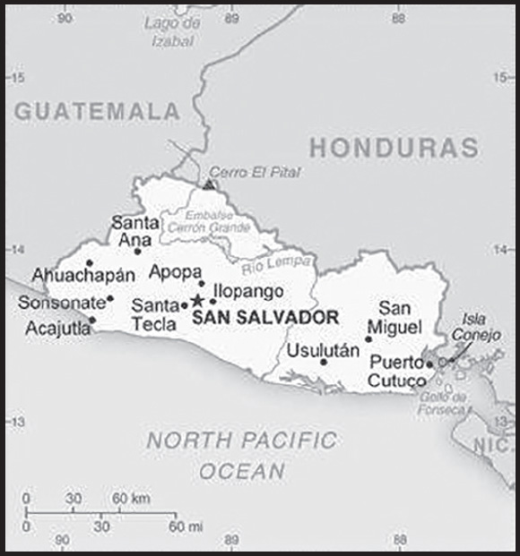
INTRODUCTION
Background: El Salvador achieved independence from Spain in 1821 and from the Central American Federation in 1839. A 12-year civil war, which cost about 75,000 lives, was brought to a close in 1992 when the government and leftist rebels signed a treaty that provided for military and political reforms. El Salvador is beset by one of the world’s highest homicide rates and pervasive criminal gangs.
GEOGRAPHY
Location: Central America, bordering the North Pacific Ocean, between Guatemala and Honduras
Geographic coordinates: 13 50 N, 88 55 W
Map references: Central America and the Caribbean
Area: total: 21,041 sq km
land: 20,721 sq km
water: 320 sq km
comparison ranking: total 153
Area - comparative: about the same size as New Jersey
Land boundaries: total: 590 km
border countries (2): Guatemala 199 km; Honduras 391 km
Coastline: 307 km
Maritime claims: territorial sea: 12 nm
contiguous zone: 24 nm
exclusive economic zone: 200 nm
Climate: tropical; rainy season (May to October); dry season (November to April); tropical on coast; temperate in uplands
Terrain: mostly mountains with narrow coastal belt and central plateau
Elevation: highest point: Cerro El Pital 2,730 m
lowest point: Pacific Ocean 0 m
mean elevation: 442 m
Natural resources: hydropower, geothermal power, petroleum, arable land
Land use: agricultural land: 74.7% (2018 est.)
arable land: 33.1% (2018 est.)
permanent crops: 10.9% (2018 est.)
permanent pasture: 30.7% (2018 est.)
forest: 13.6% (2018 est.)
other: 11.7% (2018 est.)
Irrigated land: 274 sq km (2020)
Population distribution: although it is the smallest country in land area in Central America, El Salvador has a population that is 18 times larger than Belize; at least 20% of the population lives abroad; high population density country-wide, with particular concentration around the capital of San Salvador
Natural hazards: known as the Land of Volcanoes; frequent and sometimes destructive earthquakes and volcanic activity; extremely susceptible to hurricanes
volcanism: significant volcanic activity; San Salvador (1,893 m), which last erupted in 1917, has the potential to cause major harm to the country’s capital, which lies just below the volcano’s slopes; San Miguel (2,130 m), which last erupted in 2002, is one of the most active volcanoes in the country; other historically active volcanoes include Conchaguita, Ilopango, Izalco, and Santa Ana
Geography - note: smallest Central American country and only one without a coastline on the Caribbean Sea
PEOPLE AND SOCIETY
Population: 6,602,370 (2023 est.)
comparison ranking: 109
Nationality: noun: Salvadoran(s)
adjective: Salvadoran
Ethnic groups: Mestizo 86.3%, White 12.7%, Amerindian 0.2% (includes Lenca, Kakawira, Nahua-Pipil), Black 0.1%, other 0.6% (2007 est.)
Languages: Spanish (official), Nawat (among some Amerindians)
major-language sample(s):
La Libreta Informativa del Mundo, la fuente indispensable de información básica. (Spanish)
Religions: Roman Catholic 50%, Protestant 36%, other 2%, none 12% (2014 est.)
Demographic profile: El Salvador is the smallest and most densely populated country in Central America. It is well into its demographic transition, experiencing slower population growth, a decline in its number of youths, and the gradual aging of its population. The increased use of family planning has substantially lowered El Salvador’s fertility rate, from approximately 6 children per woman in the 1970s to replacement level today. A 2008 national family planning survey showed that female sterilization remained the most common contraception method in El Salvador - its sterilization rate is among the highest in Latin America and the Caribbean - but that the use of injectable contraceptives is growing. Fertility differences between rich and poor and urban and rural women are narrowing.
Salvadorans fled during the 1979 to 1992 civil war mainly to the United States but also to Canada and to neighboring Mexico, Guatemala, Honduras, Nicaragua, and Costa Rica. Emigration to the United States increased again in the 1990s and 2000s as a result of deteriorating economic conditions, natural disasters (Hurricane Mitch in 1998 and earthquakes in 2001), and family reunification. At least 20% of El Salvador’s population lives abroad. The remittances they send home account for close to 20% of GDP, are the second largest source of external income after exports, and have helped reduce poverty.
Age structure: 0-14 years: 25.4% (male 857,304/female 819,670)
15-64 years: 66.39% (male 2,072,784/female 2,310,573)
65 years and over: 8.21% (2023 est.) (male 232,684/female 309,355)
Dependency ratios: total dependency ratio: 51.3
youth dependency ratio: 39
elderly dependency ratio: 12.3
potential support ratio: 8.1 (2021 est.)
Median age: total: 27.7 years (2020)
male: 26.2 years
female: 29.3 years
comparison ranking: total 145
Population growth rate: 0.46% (2023 est.)
comparison ranking: 156
Birth rate: 17.49 births/1,000 population (2023 est.)
comparison ranking: 86
Death rate: 5.92 deaths/1,000 population (2023 est.)
comparison ranking: 161
Net migration rate: -7.01 migrant(s)/1,000 population (2023 est.)
comparison ranking: 215
Population distribution: although it is the smallest country in land area in Central America, El Salvador has a population that is 18 times larger than Belize; at least 20% of the population lives abroad; high population density country-wide, with particular concentration around the capital of San Salvador
Urbanization: urban population: 75.4% of total population (2023)
rate of urbanization: 1.33% annual rate of change (2020-25 est.)
Major urban areas - population: 1.116 million SAN SALVADOR (capital) (2023)
Sex ratio: at birth: 1.05 male(s)/female
0-14 years: 1.05 male(s)/female
15-64 years: 0.9 male(s)/female
65 years and over: 0.75 male(s)/female
total population: 0.92 male(s)/female (2023 est.)
Mother’s mean age at first birth: 20.8 years (2008 est.)
note: data represents median age at first birth among women 25-29
Maternal mortality ratio: 43 deaths/100,000 live births (2020 est.)
comparison ranking: 100
Infant mortality rate: total: 11.9 deaths/1,000 live births (2023 est.)
male: 13.55 deaths/1,000 live births
female: 10.18 deaths/1,000 live births
comparison ranking: total 116
Life expectancy at birth: total population: 75.63 years (2023 est.)
male: 72.16 years
female: 79.27 years
comparison ranking: total population 123
Total fertility rate: 2.04 children born/woman (2023 est.)
comparison ranking: 100
Gross reproduction rate: 0.99 (2023 est.)
Contraceptive prevalence rate: 71.9% (2014)
Drinking water source: improved: urban: 99.6% of population
rural: 94.2% of population
total: 98.2% of population
unimproved: urban: 0.4% of population
rural: 5.8% of population
total: 1.8% of population (2020 est.)
Current health expenditure: 9.9% of GDP (2020)
Physicians density: 2.87 physicians/1,000 population (2018)
Hospital bed density: 1.2 beds/1,000 population (2017)
Sanitation facility access: improved: urban: 100% of population
rural: 97.1% of population
total: 99.2% of population
unimproved: urban: 0% of population
rural: 2.9% of population
total: 0.8% of population (2020 est.)
Major infectious diseases: degree of risk: high (2023)
food or waterborne diseases: bacterial and protozoal diarrhea
vectorborne diseases: dengue fever
Obesity - adult prevalence rate: 24.6% (2016)
comparison ranking: 57
Alcohol consumption per capita: total: 2.94 liters of pure alcohol (2019 est.)
beer: 1.5 liters of pure alcohol (2019 est.)
wine: 0.06 liters of pure alcohol (2019 est.)
spirits: 1.37 liters of pure alcohol (2019 est.)
other alcohols: 0 liters of pure alcohol (2019 est.)
comparison ranking: total 116
Tobacco use: total: 7.9% (2020 est.)
male: 14.1% (2020 est.)
female: 1.7% (2020 est.)
comparison ranking: total 151
Children under the age of 5 years underweight: 5% (2014)
comparison ranking: 74
Currently married women (ages 15-49): 55% (2023 est.)
Child marriage: women married by age 15: 4.3%
women married by age 18: 19.7% (2021 est.)
Education expenditures: 4.1% of GDP (2020 est.)
comparison ranking: 111
Literacy: definition: age 15 and over can read and write
total population: 89.1%
male: 91.3%
female: 87.3% (2019)
School life expectancy (primary to tertiary education): total: 12 years
male: 12 years
female: 12 years (2018)
Youth unemployment rate (ages 15-24): total: 13.7% (2021 est.)
male: 11.3%
female: 18.3%
comparison ranking: total 129
ENVIRONMENT
Environment - current issues: deforestation; soil erosion; water pollution; contamination of soils from disposal of toxic wastes
Environment - international agreements: party to: Biodiversity, Climate Change, Climate Change-Kyoto Protocol, Climate Change-Paris Agreement, Comprehensive Nuclear Test Ban, Desertification, Endangered Species, Hazardous Wastes, Nuclear Test Ban, Ozone Layer Protection, Ship Pollution, Wetlands
signed, but not ratified: Law of the Sea
Climate: tropical; rainy season (May to October); dry season (November to April); tropical on coast; temperate in uplands
Land use: agricultural land: 74.7% (2018 est.)
arable land: 33.1% (2018 est.)
permanent crops: 10.9% (2018 est.)
permanent pasture: 30.7% (2018 est.)
forest: 13.6% (2018 est.)
other: 11.7% (2018 est.)
Urbanization: urban population: 75.4% of total population (2023)
rate of urbanization: 1.33% annual rate of change (2020-25 est.)
Revenue from forest resources: 0.6% of GDP (2018 est.)
comparison ranking: 62
Revenue from coal: 0% of GDP (2018 est.)
comparison ranking: 158
Air pollutants: particulate matter emissions: 22.15 micrograms per cubic meter (2019 est.)
carbon dioxide emissions: 7.17 megatons (2016 est.)
methane emissions: 4.71 megatons (2020 est.)
Waste and recycling: municipal solid waste generated annually: 1,648,996 tons (2010 est.)
Total water withdrawal: municipal: 470 million cubic meters (2020 est.)
industrial: 210 million cubic meters (2020 est.)
agricultural: 1.43 billion cubic meters (2020 est.)
Total renewable water resources: 26.27 billion cubic meters (2020 est.)
GOVERNMENT
Country name: conventional long form: Republic of El Salvador
conventional short form: El Salvador
local long form: República de El Salvador
local short form: El Salvador
etymology: name is an abbreviation of the original Spanish conquistador designation for the area “Provincia de Nuestro Senor Jesus Cristo, el Salvador del Mundo” (Province of Our Lord Jesus Christ, the Saviour of the World), which became simply “El Salvador” (The Savior)
Government type: presidential republic
Capital: name: San Salvador
geographic coordinates: 13 42 N, 89 12 W
time difference: UTC-6 (1 hour behind Washington, DC, during Standard Time)
etymology: Spanish for “Holy Savior” (referring to Jesus Christ)
Administrative divisions: 14 departments (departamentos, singular - departamento); Ahuachapan, Cabanas, Chalatenango, Cuscatlan, La Libertad, La Paz, La Union, Morazan, San Miguel, San Salvador, San Vicente, Santa Ana, Sonsonate, Usulutan
Independence: 15 September 1821 (from Spain)
National holiday: Independence Day, 15 September (1821)
Constitution: history: many previous; latest drafted 16 December 1983, enacted 23 December 1983
amendments: proposals require agreement by absolute majority of the Legislative Assembly membership; passage requires at least two-thirds majority vote of the Assembly; constitutional articles on basic principles, and citizen rights and freedoms cannot be amended; amended 2003, 2009, 2014
Legal system: civil law system with minor common law influence; judicial review of legislative acts in the Supreme Court
International law organization participation: has not submitted an ICJ jurisdiction declaration; non-party state to the ICCt
Citizenship: citizenship by birth: yes
citizenship by descent only: yes
dual citizenship recognized: yes
residency requirement for naturalization: 5 years
Suffrage: 18 years of age; universal
Executive branch: chief of state: President Nayib Armando BUKELE Ortez (since 1 June 2019); Vice President Félix Augusto Antonio ULLOA Garay (since 1 June 2019); note - the president is both chief of state and head of government
head of government: President Nayib Armando BUKELE Ortez (since 1 June 2019); Vice President Félix Augusto Antonio ULLOA Garay (since 1 June 2019)
cabinet: Council of Ministers selected by the president
elections/appointments: president and vice president directly elected on the same ballot by absolute majority popular vote in 2 rounds if needed for a single 5-year term; election last held on 3 February 2019 (next to be held on February 2024)
election results:
2019: Nayib Armando BUKELE Ortez elected president - Nayib Armando BUKELE Ortez (GANA) 53.1%, Carlos CALLEJA Hakker (ARENA) 31.72%, Hugo MARTINEZ (FMLN) 14.41%, other 0.77%
2014: Salvador SANCHEZ CEREN elected president in second round; percent of vote in first round - Salvador SANCHEZ CEREN (FMLN) 48.9%, Norman QUIJANO (ARENA) 39%, Antonio SACA (CN) 11.4%, other 0.7%; percent of vote in second round - Salvador SANCHEZ CEREN 50.1%, Norman QUIJANO 49.9%
Legislative branch: description: unicameral Legislative Assembly or Asamblea Legislativa (84 seats; members directly elected in multi-seat constituencies and a single nationwide constituency by open-list proportional representation vote to serve 3-year terms)
elections: last held on 28 February 2021 (next to be held in 2024)
election results: percent of vote by party - NI 66.5%, ARENA 12.2%, FMLN 6.9%, GANA 5.3%, PCN 4.1%, other 5%; seats by party - NI 56, ARENA 14, GANA 5, FMLN 4, other 5; composition - men 61, women 23, percent of women 27.4%
Judicial branch: highest court(s): Supreme Court or Corte Suprema de Justicia (consists of 15 judges, including its president, and 15 substitute judges organized into Constitutional, Civil, Penal, and Administrative Conflict Chambers)
judge selection and term of office: judges elected by the Legislative Assembly on the recommendation of both the National Council of the Judicature, an independent body elected by the Legislative Assembly, and the Bar Association; judges elected for 9-year terms, with renewal of one-third of membership every 3 years; consecutive reelection is allowed
subordinate courts: Appellate Courts; Courts of First Instance; Courts of Peace
Political parties and leaders: Christian Democratic Party or PDC [Reynaldo CARBALLO]
Farabundo Marti National Liberation Front or FMLN [Oscar ORTIZ]
Great Alliance for National Unity or GANA [Nelson GUARDADO]
National Coalition Party or PCN [Manuel RODRIGUEZ]
Nationalist Republican Alliance or ARENA [Erick SALGUERO]
New Ideas (Nuevas Ideas) or NI [Xavier Zablah BUKELE]
Our Time (Nuestro Tiempo) or NT [Juan VALIENTE]
Vamos or V [Josue ALVARADO Flores]
International organization participation: BCIE, CACM, CD, CELAC, FAO, G-11, G-77, IADB, IAEA, IBRD, ICAO, ICC (national committees), ICRM, IDA, IFAD, IFC, IFRCS, ILO, IMF, IMO, Interpol, IOC, IOM, IPU, ISO (correspondent), ITSO, ITU, ITUC (NGOs), LAES, LAIA (observer), MIGA, MINURSO, MINUSTAH, NAM (observer), OAS, OPANAL, OPCW, Pacific Alliance (observer), PCA, Petrocaribe, SICA, UN, UNCTAD, UNESCO, UNIDO, UNIFIL, Union Latina, UNISFA, UNMISS, UNOCI, UNWTO, UPU, WCO, WFTU (NGOs), WHO, WIPO, WMO, WTO
Diplomatic representation in the US: chief of mission: Ambassador Carmen Milena MAYORGA VALERA (since 23 December 2020)
chancery: 1400 16th Street NW, Suite 100, Washington, DC 20036
telephone: [1] (202) 595-7500
FAX: [1] (202) 232-3763
email address and website:
consulate(s) general: Atlanta, Boston, Brentwood (NY), Charlotte, Chicago, Dallas, Denver, Houston, Las Vegas (NV), Laredo (TX), Los Angeles, McAllen (TX), New York, San Bernardino (CA), San Francisco, Tucson (AZ), Washington (DC), Woodbridge (VA)
Diplomatic representation from the US: chief of mission: Ambassador William H. DUNCAN (since 24 January 2023)
embassy: Final Boulevard Santa Elena, Antiguo Cuscatlan, La Libertad, San Salvador mailing address: 3450 San Salvador Place, Washington, DC 20521-3450
telephone: [503] 2501-2999
FAX: [503] 2501-2150
email address and website:
Flag description: three equal horizontal bands of cobalt blue (top), white, and cobalt blue with the national coat of arms centered in the white band; the coat of arms features a round emblem encircled by the words REPUBLICA DE EL SALVADOR EN LA AMERICA CENTRAL; the banner is based on the former blue-white-blue flag of the Federal Republic of Central America; the blue bands symbolize the Pacific Ocean and the Caribbean Sea, while the white band represents the land between the two bodies of water, as well as peace and prosperity
note: similar to the flag of Nicaragua, which has a different coat of arms centered in the white band; also similar to the flag of Honduras, which has five blue stars arranged in an X pattern centered in the white band
National symbol(s): turquoise-browed motmot (bird); national colors: blue, white
National anthem: name: “Himno Nacional de El Salvador” (National Anthem of El Salvador)
lyrics/music: Juan Jose CANAS/Juan ABERLE
note: officially adopted 1953, in use since 1879; at 4:20 minutes, the anthem of El Salvador is one of the world’s longest
National heritage: total World Heritage Sites: 1 (cultural)
selected World Heritage Site locales: Joya de Cerén Archaeological Site
ECONOMY
Economic overview: growth-challenged Central American economy buttressed via remittances; dense labor force; fairly aggressive COVID-19 stimulus plan; new and lower banking reserve requirements; earthquake, tropical storm, and crime disruptions; widespread corruption
Real GDP (purchasing power parity): $57.371 billion (2021 est.)
$52.024 billion (2020 est.)
$56.657 billion (2019 est.)
note: data are in 2017 dollars
comparison ranking: 110
Real GDP growth rate: 10.28% (2021 est.)
-8.18% (2020 est.)
2.44% (2019 est.)
comparison ranking: 30
Real GDP per capita: $9,100 (2021 est.)
$8,300 (2020 est.)
$9,000 (2019 est.)
note: data are in 2017 dollars
comparison ranking: 148
GDP (official exchange rate)
$27.023 billion (2019 est.)
Inflation rate (consumer prices): 3.47% (2021 est.)
-0.37% (2020 est.)
0.08% (2019 est.)
comparison ranking: 109
Credit ratings: Fitch rating: B- (2017)
Moody’s rating: B3 (2018)
Standard & Poors rating: B- (2018)
note: The year refers to the year in which the current credit rating was first obtained.
GDP - composition, by sector of origin
agriculture: 12% (2017 est.)
industry: 27.7% (2017 est.)
services: 60.3% (2017 est.)
comparison rankings: services 123; industry 96; agriculture 78
GDP - composition, by end use
household consumption: 84.5% (2017 est.)
government consumption: 15.8% (2017 est.)
investment in fixed capital: 16.9% (2017 est.)
investment in inventories: 0% (2017 est.)
exports of goods and services: 27.6% (2017 est.)
imports of goods and services: -44.9% (2017 est.)
Agricultural products: sugar cane, maize, milk, poultry, sorghum, beans, coconuts, eggs, apples, oranges
Industries: food processing, beverages, petroleum, chemicals, fertilizer, textiles, furniture, light metals
Industrial production growth rate: 9.47% (2021 est.)
comparison ranking: 32
Labor force: 2.658 million (2021 est.)
comparison ranking: 114
Labor force - by occupation: agriculture: 21%
industry: 20%
services: 58% (2011 est.)
Unemployment rate: 5.94% (2021 est.)
6.25% (2020 est.)
4.17% (2019 est.)
note: data are official rates; but underemployment is high
comparison ranking: 131
Youth unemployment rate (ages 15-24): total: 13.7% (2021 est.)
male: 11.3%
female: 18.3%
comparison ranking: total 129
Population below poverty line: 22.8% (2019 est.)
Gini Index coefficient - distribution of family income: 38.8 (2019 est.)
comparison ranking: 63
Average household expenditures: on food: 26.5% of household expenditures (2018 est.)
on alcohol and tobacco: 0.5% of household expenditures (2018 est.)
Household income or consumption by percentage share: lowest 10%: 2.2%
highest 10%: 32.3% (2014 est.)
Budget: revenues: $6.448 billion (2019 est.)
expenditures: $7.273 billion (2019 est.)
Budget surplus (+) or deficit (-): -2.5% (of GDP) (2017 est.)
comparison ranking: 113
Public debt: 71.41% of GDP (2020 est.)
53.88% of GDP (2019 est.)
52.21% of GDP (2018 est.)
note: El Salvador’s total public debt includes non-financial public sector debt, financial public sector debt, and central bank debt
comparison ranking: 58
Taxes and other revenues: 18.66% (of GDP) (2020 est.)
comparison ranking: 102
Fiscal year: calendar year
Current account balance: -$1.457 billion (2021 est.)
$202.947 million (2020 est.)
-$113.356 million (2019 est.)
comparison ranking: 144
Exports: $8.491 billion (2021 est.) note: data are in current year dollars
$6.295 billion (2020 est.) note: data are in current year dollars
$8.057 billion (2019 est.) note: data are in current year dollars
comparison ranking: 113
Exports - partners: United States 40%, Guatemala 15%, Honduras 15%, Nicaragua 6% (2019)
Exports - commodities: clothing, electrical capacitors, plastic lids, sugar, packaged medicines, toilet paper (2021)
Imports: $15.754 billion (2021 est.) note: data are in current year dollars
$10.764 billion (2020 est.) note: data are in current year dollars
$12.469 billion (2019 est.) note: data are in current year dollars
comparison ranking: 98
Imports - partners: United States 30%, China 14%, Guatemala 13%, Mexico 8%, Honduras 6% (2019)
Imports - commodities: refined petroleum, packaged medicines, clothing, broadcasting equipment, natural gas (2019)
Reserves of foreign exchange and gold: $3.426 billion (31 December 2021 est.)
$3.083 billion (31 December 2020 est.)
$4.446 billion (31 December 2019 est.)
comparison ranking: 114
Debt - external: $17.24 billion (2019 est.)
$16.712 billion (2018 est.)
comparison ranking: 100
Exchange rates: note: the US dollar is used as a medium of exchange and circulates freely in the economy
Exchange rates: 1 (2021 est.)
1 (2020 est.)
1 (2019 est.)
1 (2018 est.)
1 (2017 est.)
ENERGY
Electricity access: population without electricity: (2020) less than 1 million
electrification - total population: 97.8% (2021)
electrification - urban areas: 99.2% (2021)
electrification - rural areas: 94% (2021)
Electricity: installed generating capacity: 2.586 million kW (2020 est.)
consumption: 6,443,200,000 kWh (2019 est.)
exports: 158 million kWh (2019 est.)
imports: 1.45 billion kWh (2019 est.)
transmission/distribution losses: 795.8 million kWh (2019 est.)
comparison rankings: installed generating capacity 112; transmission/distribution losses 120; imports 65; exports 88; consumption 115
Electricity generation sources: fossil fuels: 28.2% of total installed capacity (2020 est.)
solar: 7.5% of total installed capacity (2020 est.)
hydroelectricity: 30% of total installed capacity (2020 est.)
geothermal: 22.2% of total installed capacity (2020 est.)
biomass and waste: 12.1% of total installed capacity (2020 est.)
Coal: production: 0 metric tons (2020 est.)
consumption: 1,000 metric tons (2020 est.)
exports: 0 metric tons (2020 est.)
imports: 1,000 metric tons (2020 est.)
proven reserves: 0 metric tons (2019 est.)
Petroleum: total petroleum production: 0 bbl/day (2021 est.)
refined petroleum consumption: 59,100 bbl/day (2019 est.)
crude oil estimated reserves: 0 barrels (2021 est.)
Refined petroleum products - production: 0 bbl/day (2015 est.)
comparison ranking: 170
Refined petroleum products - exports: 347 bbl/day (2015 est.)
comparison ranking: 115
Refined petroleum products - imports: 49,280 bbl/day (2015 est.)
comparison ranking: 82
Carbon dioxide emissions: 7.632 million metric tonnes of CO2 (2019 est.)
from coal and metallurgical coke: 2,000 metric tonnes of CO2 (2019 est.)
from petroleum and other liquids: 7.63 million metric tonnes of CO2 (2019 est.)
comparison ranking: total emissions 122
Energy consumption per capita: 24.124 million Btu/person (2019 est.)
comparison ranking: 131
COMMUNICATIONS
Telephones - fixed lines: total subscriptions: 856,090 (2021 est.)
subscriptions per 100 inhabitants: 14 (2021 est.)
comparison ranking: total subscriptions 74
Telephones - mobile cellular: total subscriptions: 11,071,073 (2021 est.)
subscriptions per 100 inhabitants: 175 (2021 est.)
comparison ranking: total subscriptions 87
Telecommunication systems: general assessment: El Salvador is the smallest country in central America geographically, it has the fourth largest economy in the region; the country’s telecom sector has been restricted by poor infrastructure and unequal income distribution; there have been organizational delays which have slowed the development of telecom services; El Salvador’s fixed-line teledensity is substantially lower than the Latin American and Caribbean average; there has been a significant drop in the number of fixed lines since 2010, particularly in 2017, largely due to the substitution for mobile-only alternatives; about 94% of all telephony lines in the country are on mobile networks; mobile subscriptions are remarkably high considering El Salvador’s economic indicators, being about a third higher than average for Latin America and the Caribbean; the country was one of the last in the region to provide LTE services, mainly due to the inadequate provision of suitable spectrum; the multi-spectrum auction conducted at the end of 2019 has allowed MNOs to improve the reach and quality of their service offerings; El Salvador’s telecom legislation is one of the more liberal in Latin America, encouraging competition in most areas and permitting foreign investment; there are no regulations which promote wholesale broadband; the only effective cross-platform competition in the broadband market comes from the few cable operators; there has been some market consolidation in recent years (2021)
domestic: fixed-line services, roughly 14 per 100, mobile-cellular competition now at 175 subscribers per 100 inhabitants (2021)
international: country code - 503; satellite earth station - 1 Intelsat (Atlantic Ocean); connected to Central American Microwave System (2019)
Broadcast media: multiple privately owned national terrestrial TV networks, supplemented by cable TV networks that carry international channels; hundreds of commercial radio broadcast stations and two known government-owned radio broadcast station; transition to digital transmission to begin in 2018 along with adaptation of the Japanese-Brazilian Digital Standard (ISDB- T) (2022)
Internet country code: .sv
Internet users: total: 3.969 million (2021 est.)
percent of population: 63% (2021 est.)
comparison ranking: total 109
Broadband - fixed subscriptions: total: 586,000 (2020 est.)
subscriptions per 100 inhabitants: 9 (2020 est.)
comparison ranking: total 87
TRANSPORTATION
National air transport system: number of registered air carriers: 1 (2020)
inventory of registered aircraft operated by air carriers: 13
annual passenger traffic on registered air carriers: 2,545,105 (2018)
annual freight traffic on registered air carriers: 10.73 million (2018) mt-km
Civil aircraft registration country code prefix: YS
Airports: 68 (2021)
comparison ranking: total 73
Airports - with paved runways: 5
note: paved runways have a concrete or asphalt surface but not all have facilities for refueling, maintenance, or air traffic control; the length of a runway required for aircraft to safely operate depends on a number of factors including the type of aircraft, the takeoff weight (including passengers, cargo, and fuel), engine types, flap settings, landing speed, elevation of the airport, and average maximum daily air temperature; paved runways can reach a length of 5,000 m (16,000 ft.), but the “typical” length of a commercial airline runway is between 2,500-4,000 m (8,000-13,000 ft.)
Airports - with unpaved runways: 63
note: unpaved runways have a surface composition such as grass or packed earth and are most suited to the operation of light aircraft; unpaved runways are usually short, often less than 1,000 m (3,280 ft.) in length; airports with unpaved runways often lack facilities for refueling, maintenance, or air traffic control
Heliports: 2 (2021)
Railways: total: 12.5 km (2014)
narrow gauge: 12.5 km (2014) 0.914-mm gauge
comparison ranking: total 136
Roadways: total: 9,012 km (2017)
paved: 5,341 km (2017)
unpaved: 3,671 km (2017)
comparison ranking: total 138
Waterways: 422 km (2022) (Rio Lempa River is partially navigable by small craft)
comparison ranking: 95
Merchant marine: total: 4 (2022)
by type: other 4
comparison ranking: total 168
Ports and terminals: major seaport(s): Puerto Cutuco
oil terminal(s): Acajutla offshore terminal
MILITARY AND SECURITY
Military and security forces: the Armed Force of El Salvador (La Fuerza Armada de El Salvador, FAES): Army of El Salvador (Ejercito de El Salvador, ES), Navy of El Salvador (Fuerza Naval de El Salvador, FNES), Salvadoran Air Force (Fuerza Aerea Salvadorena, FAS) (2023)
note: the National Civil Police (Policia Nacional Civil, PNC) are under the Ministry of Justice and Public Safety; in 2016, El Salvador created a combined Army commando and PNC unit to combat criminal gang violence
Military expenditures: 1.2% of GDP (2022 est.)
1.2% of GDP (2021 est.)
1.2% of GDP (2020 est.)
1.2% of GDP (2019 est.)
1.1% of GDP (2018 est.)
comparison ranking: 110
Military and security service personnel strengths: approximately 25,000 active military personnel (21,000 Army; 2,000 Navy; 2,000 Air Force) (2023)
Military equipment inventories and acquisitions: the FAES has a mix of mostly older imported platforms, largely from the US (2023)
Military service age and obligation: 18-30 years of age for selective compulsory military service; 16-22 years of age for voluntary military service for men and women; service obligation is 12 months, with 11 months for officers and non-commissioned officers (2023)
note: as of 2016, women made up about 6% of the active duty military
Military deployments: 110 Mali (MINUSMA) (2023)
Military - note: the Armed Force of El Salvador (FAES) is responsible for defending national sovereignty and ensuring territorial integrity but also has considerable domestic security responsibilities; while the National Civil Police (PNC) is responsible for maintaining public security, the country’s constitution allows the president to use the FAES “in exceptional circumstances” to maintain internal peace and public security; in 2016, the government created a special 1,000-strong joint unit of Army commandos and police to fight criminal gangs; more military personnel were devoted to internal security beginning in 2019 when President BUKELE signed a decree authorizing military involvement in police duties to combat rising gang violence, organized crime, and narcotics trafficking, as well as assisting with border security; since the decree, a considerable portion of the Army has been deployed in support of the PNC; in multiple cases since 2022, for example, as many as 8,000 troops have been deployed alongside thousands of police on operations against criminal gang members
the FAES trains regularly, as well as with regional partners and the US, in such areas as internal security and disaster relief operations; it has deployed small numbers of personnel on UN peacekeeping missions and in support of military operations in Iraq (2003-2009); the FAES is deployed throughout the country in zones; the Army’s combat units are 6 infantry brigades, plus a special security brigade comprised of border guards and military police, and an artillery brigade; the Navy operates about 10 patrol boats and has a small force of naval commandos; the Air Force has a few dozen light ground attack fixed-wing aircraft and multirole helicopters
the military led the country for much of the 20th century; from 1980 to 1992, it fought a bloody civil war against guerrillas from the Farabundo Martí National Liberation Front or FMLN, the paramilitary arm of the Democratic Revolutionary Front (Frente Democrático Revolucionario), a coalition of left-wing dissident political groups backed by Cuba and the Soviet Union; the FAES received considerable US support during the conflict; significant human rights violations occurred during the war and approximately 75,000 Salvadorans, mostly civilians, were killed (2023)
SPACE
Space agency/agencies: El Salvador Aerospace Institute (ESAI; established 2018) is an aerospace think tank that is authorized by the Salvadoran Government decree to lead the country’s national aerospace strategy (2023)
Space program overview: small, nascent space effort; ESAI serves as a link and coordination body for the aerospace industry with a focus on research, development, and innovation, particularly in the fields of science, technology, and engineering; has sought training and cooperation on space programs from South Korea and Turkey (2023)
note: further details about the key activities, programs, and milestones of the country’s space program, as well as government spending estimates on the space sector, appear in Appendix S
TRANSNATIONAL ISSUES
Disputes - international: El Salvador-Honduras: International Court of Justice (ICJ) ruled on the delimitation of “bolsones” (disputed areas) along the El Salvador-Honduras border in 1992 with final settlement by the parties in 2006 after an Organization of American States survey and a further ICJ ruling in 2003; the 1992 ICJ ruling advised a tripartite resolution to a maritime boundary in the Gulf of Fonseca with consideration of Honduran access to the Pacific; El Salvador continues to claim tiny Conejo Island, not mentioned in the ICJ ruling, off Honduras in the Gulf of Fonseca.
Refugees and internally displaced persons:
IDPs: 52,000 (2022)
Trafficking in persons: tier rating: Tier 2 Watch List — El Salvador does not fully meet the minimum standards for the elimination of trafficking but is making significant efforts to do so; El Salvador hired more police and prosecutors in specialized anti-trafficking units and provided awareness training for Salvadorans participating in temporary work programs abroad; however, the government did not demonstrate overall increasing efforts, compared with the previous year, to improve its anti-trafficking capacity; the government investigated, prosecuted, and convicted fewer traffickers; less than half of all victims received government services or referrals to care providers, and services provided were inadequate; the government arrested and detained thousands of suspected gang members, disabling criminal networks that fueled demand for sex and labor trafficking, but authorities arrested and detained children affiliated with gangs without screening for trafficking indicators; interagency coordination remained weak, government data was unreliable, and the national anti-trafficking council did not reconcile the data or publish a report on the government’s 2022 efforts; therefore, El Salvador remained on Tier 2 Watch list (2023)
trafficking profile: human traffickers exploit domestic and foreign victims in El Salvador, and traffickers exploit victims from El Salvador abroad; adults and children are exploited in sex trafficking within the country; orphans, adolescent girls, and LGBTQI+ persons are at particular risk; sex trafficking reportedly occurs in the tourism industry; traffickers exploit victims within their own communities or homes, sometimes their own children or other family members; Salvadoran adults and children are exploited in forced labor in agriculture, domestic service, and begging; adults and children from neighboring countries—particularly Guatemala, Honduras, and Nicaragua—are exploited in sex trafficking and forced labor in construction, domestic service, or the informal sector; traffickers recruit victims in regions of El Salvador with high levels of violence and capitalize on fear to coerce victims and their families through threats of violence; in 2022, territorial gang control decreased dramatically across El Salvador, following the arrests of thousands of suspected gang members under the government’s state of exception; reports indicate extortion and violence declined significantly, but no data is available on the state of exception’s impact on trafficking; prior to the state of exception, limited government presence in gang-controlled territory exacerbated trafficking risks among vulnerable groups; many families were displaced fleeing gang exploitation of children; transnational criminal organizations and gangs, including MS-13 and Barrio 18, recruited, abducted, trained, armed, and subjected children to forced labor—including assassinations, extortion, and drug trafficking; these groups subjected women and children, including LGBTQI+ children, to sex trafficking and forced labor in domestic service and child care; Salvadoran men, women, and children are exploited in sex trafficking and forced labor in Belize, Guatemala, Mexico, and the US; traffickers exploit some Salvadorans who irregularly migrate to the US in forced labor, criminal activity, and sex trafficking en route or upon arrival; traffickers exploit some victims from Asia, South America, or other Central American countries in sex and labor trafficking in El Salvador; reported corruption and complicity among some government officials may have obstructed anti-trafficking law enforcement efforts (2023)
Illicit drugs: a transit country for illicit drugs destined for the United States; a major source of precursor or essential chemicals used in the production of illicit narcotics
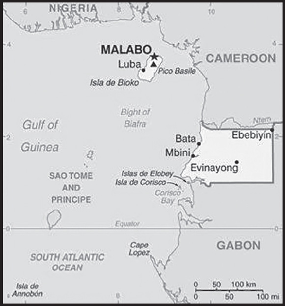
INTRODUCTION
Background: Equatorial Guinea consists of a continental territory and five inhabited islands; it is one of the smallest countries by area and population in Africa. The mainland region, contemporarily known as Rio Muni, was most likely predominantly inhibited by Pygmy ethnic groups prior to the migration of various Bantu-speaking ethnic groups around the second millennium BC. The island of Bioko, the largest of Equatorial Guinea’s five inhabited islands and the location of the country’s capital of Malabo, has been occupied since at least 1000 B.C. In the early 1470s, Portuguese explorers landed on Bioko Island and Portugal soon after established control of the island and other areas of modern Equatorial Guinea. In 1778, Portugal ceded its colonial hold over present-day Equatorial Guinea to Spain in the Treaty of El Pardo. The borders of modern-day Equatorial Guinea would evolve between 1778 and 1968 as the area remained under European colonial rule.
In 1968, Equatorial Guinea was granted independence from Spain and elected Francisco MACIAS NGUEMA as its first president. President MACIAS consolidated power soon after his election and ruled brutally for approximately 11 years. Under his regime, Equatorial Guinea experienced mass suppression, purges, and killings. Some estimates indicate that a third of the population either went into exile or was killed under President MACIAS’ rule. In 1979, present-day President Teodoro OBIANG NGUEMA MBASOGO, then a senior military officer, deposed President MACIAS in a violent coup. President OBIANG has ruled since and has been elected in non-competitive contests several times, most recently in November 2022. The president exerts almost total control over the political system and there is nearly no space for political opposition. Equatorial Guinea experienced rapid economic growth in the early years of the 21st century due to the discovery of large offshore oil reserves in 1996. Production peaked in 2004 and has declined since. The country’s economic windfall from oil production resulted in massive increases in government revenue, a significant portion of which was designated for the development of infrastructure. Systemic corruption, however, has hindered socio-economic development and there have been limited improvements in the population’s living standards. Equatorial Guinea continues to seek to diversify its economy, increase foreign investment, and assume a greater role in regional and international affairs.
GEOGRAPHY
Location: Central Africa, bordering the Bight of Biafra, between Cameroon and Gabon
Geographic coordinates: 2 00 N, 10 00 E
Map references: Africa
Area: total: 28,051 sq km
land: 28,051 sq km
water: 0 sq km
comparison ranking: total 145
Area - comparative: slightly smaller than Maryland
Land boundaries: total: 528 km
border countries (2): Cameroon 183 km; Gabon 345 km
Coastline: 296 km
Maritime claims: territorial sea: 12 nm
exclusive economic zone: 200 nm
Climate: tropical; always hot, humid
Terrain: coastal plains rise to interior hills; islands are volcanic
Elevation: highest point: Pico Basile 3,008 m
lowest point: Atlantic Ocean 0 m
mean elevation: 577 m
Natural resources: petroleum, natural gas, timber, gold, bauxite, diamonds, tantalum, sand and gravel, clay
Land use: agricultural land: 10.1% (2018 est.)
arable land: 4.3% (2018 est.)
permanent crops: 2.1% (2018 est.)
permanent pasture: 3.7% (2018 est.)
forest: 57.5% (2018 est.)
other: 32.4% (2018 est.)
Population distribution: only two large cities over 30,000 people (Bata on the mainland, and the capital Malabo on the island of Bioko); small communities are scattered throughout the mainland and the five inhabited islands as shown in this population distribution map
Natural hazards: violent windstorms; flash floods
volcanism: Santa Isabel (3,007 m), which last erupted in 1923, is the country’s only historically active volcano; Santa Isabel, along with two dormant volcanoes, form Bioko Island in the Gulf of Guinea
Geography - note: insular and continental regions widely separated; despite its name, no part of the Equator passes through Equatorial Guinea; the mainland part of the country is located just north of the Equator
PEOPLE AND SOCIETY
Population: 1,737,695 (2023 est.)
comparison ranking: 154
Nationality: noun: Equatorial Guinean(s) or Equatoguinean(s)
adjective: Equatorial Guinean or Equatoguinean
Ethnic groups: Fang 85.7%, Bubi 6.5%, Ndowe 3.6%, Annobon 1.6%, Bujeba 1.1%, other 1.4% (1994 est.)
Languages: Spanish (official) 67.6%, other (includes Fang, Bubi, Portuguese (official), French (official), Portuguese-based Creoles spoken in Ano Bom) 32.4% (1994 est.)
major-language sample(s):
La Libreta Informativa del Mundo, la fuente indispensable de información básica. (Spanish)
Religions: Roman Catholic 88%, Protestant 5%, Muslim 2%, other 5% (animist, Baha’i, Jewish) (2015 est.)
Demographic profile: Equatorial Guinea is one of the smallest and least populated countries in continental Africa and is the only independent African country where Spanish is an official language. Despite a boom in oil production in the 1990s, authoritarianism, corruption, and resource mismanagement have concentrated the benefits among a small elite. These practices have perpetuated income inequality and unbalanced development, such as low public spending on education and health care. Unemployment remains problematic because the oil-dominated economy employs a small labor force dependent on skilled foreign workers. The agricultural sector, Equatorial Guinea’s main employer, continues to deteriorate because of a lack of investment and the migration of rural workers to urban areas. About two-thirds of the population lives below the poverty line as of 2020.
Equatorial Guinea’s large and growing youth population – about 60% are under the age of 25 as of 2022 – is particularly affected because job creation in the non-oil sectors is limited, and young people often do not have the skills needed in the labor market. Equatorial Guinean children frequently enter school late, have poor attendance, and have high dropout rates. Thousands of Equatorial Guineans fled across the border to Gabon in the 1970s to escape the dictatorship of Francisco MACIAS NGUEMA; smaller numbers have followed in the decades since. Continued inequitable economic growth and high youth unemployment increases the likelihood of ethnic and regional violence.
Age structure: 0-14 years: 36.05% (male 323,846/female 302,666)
15-64 years: 59.01% (male 561,260/female 464,130)
65 years and over: 4.94% (2023 est.) (male 44,561/female 41,232)
Dependency ratios: total dependency ratio: 72.2
youth dependency ratio: 66.7
elderly dependency ratio: 5.4
potential support ratio: 18.5 (2021 est.)
Median age: total: 20.3 years (2020)
male: 19.9 years
female: 20.7 years
comparison ranking: total 193
Population growth rate: 3.36% (2023 est.)
comparison ranking: 5
Birth rate: 29.46 births/1,000 population (2023 est.)
comparison ranking: 30
Death rate: 8.9 deaths/1,000 population (2023 est.)
comparison ranking: 64
Net migration rate: 13.01 migrant(s)/1,000 population (2023 est.)
comparison ranking: 5
Population distribution: only two large cities over 30,000 people (Bata on the mainland, and the capital Malabo on the island of Bioko); small communities are scattered throughout the mainland and the five inhabited islands as shown in this population distribution map
Urbanization: urban population: 74.4% of total population (2023)
rate of urbanization: 3.62% annual rate of change (2020-25 est.)
Major urban areas - population: 297,000 MALABO (capital) (2018)
Sex ratio: at birth: 1.03 male(s)/female
0-14 years: 1.07 male(s)/female
15-64 years: 1.21 male(s)/female
65 years and over: 1.08 male(s)/female
total population: 1.15 male(s)/female (2023 est.)
Maternal mortality ratio: 212 deaths/100,000 live births (2020 est.)
comparison ranking: 45
Infant mortality rate: total: 77.85 deaths/1,000 live births (2023 est.)
male: 83.76 deaths/1,000 live births
female: 71.77 deaths/1,000 live births
comparison ranking: total 4
Life expectancy at birth: total population: 63.8 years (2023 est.)
male: 61.53 years
female: 66.13 years
comparison ranking: total population 208
Total fertility rate: 4.19 children born/woman (2023 est.)
comparison ranking: 22
Gross reproduction rate: 2.06 (2023 est.)
Drinking water source: improved: urban: 81.7% of population
rural: 32.1% of population
total: 67.6% of population
unimproved: urban: 18.3% of population
rural: 67.9% of population
total: 32.4% of population (2017 est.)
Current health expenditure: 3.8% of GDP (2020)
Physicians density: 0.4 physicians/1,000 population (2017)
Sanitation facility access: improved: urban: 81.2% of population
rural: 63.4% of population
total: 76.2% of population
unimproved: urban: 18.8% of population
rural: 36.6% of population
total: 23.8% of population (2020 est.)
Major infectious diseases: degree of risk: very high (2023)
food or waterborne diseases: bacterial and protozoal diarrhea, hepatitis A, and typhoid fever
vectorborne diseases: malaria and dengue fever
animal contact diseases: rabies
Obesity - adult prevalence rate: 8% (2016)
comparison ranking: 156
Alcohol consumption per capita: total: 6.11 liters of pure alcohol (2019 est.)
beer: 3.83 liters of pure alcohol (2019 est.)
wine: 1.24 liters of pure alcohol (2019 est.)
spirits: 0.99 liters of pure alcohol (2019 est.)
other alcohols: 0.05 liters of pure alcohol (2019 est.)
comparison ranking: total 69
Currently married women (ages 15-49): 60.2% (2023 est.)
Literacy: definition: age 15 and over can read and write
total population: 95.3%
male: 97.4%
female: 93% (2015)
Youth unemployment rate (ages 15-24): total: 18.3% (2021 est.)
male: 17.1%
female: 19.9%
comparison ranking: total 93
ENVIRONMENT
Environment - current issues: deforestation (forests are threatened by agricultural expansion, fires, and grazing); desertification; water pollution (tap water is non-potable); wildlife preservation
Environment - international agreements: party to: Biodiversity, Climate Change, Climate Change-Kyoto Protocol, Climate Change-Paris Agreement, Desertification, Endangered Species, Hazardous Wastes, Law of the Sea, Marine Dumping-London Convention, Nuclear Test Ban, Ozone Layer Protection, Ship Pollution, Wetlands
signed, but not ratified: Comprehensive Nuclear Test Ban
Climate: tropical; always hot, humid
Land use: agricultural land: 10.1% (2018 est.)
arable land: 4.3% (2018 est.)
permanent crops: 2.1% (2018 est.)
permanent pasture: 3.7% (2018 est.)
forest: 57.5% (2018 est.)
other: 32.4% (2018 est.)
Urbanization: urban population: 74.4% of total population (2023)
rate of urbanization: 3.62% annual rate of change (2020-25 est.)
Revenue from forest resources: 1.52% of GDP (2018 est.)
comparison ranking: 42
Revenue from coal: 0% of GDP (2018 est.)
comparison ranking: 135
Air pollutants: particulate matter emissions: 25.67 micrograms per cubic meter (2019 est.)
carbon dioxide emissions: 5.65 megatons (2016 est.)
methane emissions: 11.21 megatons (2020 est.)
Waste and recycling: municipal solid waste generated annually: 198,443 tons (2016 est.)
Total water withdrawal: municipal: 20 million cubic meters (2020 est.)
industrial: 3 million cubic meters (2017 est.)
agricultural: 1 million cubic meters (2017 est.)
Total renewable water resources: 26 billion cubic meters (2020 est.)
GOVERNMENT
Country name: conventional long form: Republic of Equatorial Guinea
conventional short form: Equatorial Guinea
local long form: Republica de Guinea Ecuatorial (Spanish)/ Republique de Guinee Equatoriale (French)
local short form: Guinea Ecuatorial (Spanish)/ Guinee Equatoriale (French)
former: Spanish Guinea
etymology: the country is named for the Guinea region of West Africa that lies along the Gulf of Guinea and stretches north to the Sahel; the “equatorial” refers to the fact that the country lies just north of the Equator
Government type: presidential republic
Capital: name: Malabo; note - Malabo is on the island of Bioko; in 2017, some governmental offices began to move to a new capital of Ciudad de la Paz (formerly referred to as Oyala) on the mainland near Djibloho, but a lack of funds has halted progress on construction
geographic coordinates: 3 45 N, 8 47 E
time difference: UTC+1 (6 hours ahead of Washington, DC, during Standard Time)
etymology: named after King MALABO (Malabo Lopelo Melaka) (1837–1937), the last king of the Bubi, the ethnic group indigenous to the island of Bioko; the name of the new capital, Ciudad de la Paz, translates to “City of Peace” in Spanish
Administrative divisions: 8 provinces (provincias, singular - provincia); Annobon, Bioko Norte, Bioko Sur, Centro Sur, Djibloho, Kie-Ntem, Litoral, Wele-Nzas
Independence: 12 October 1968 (from Spain)
National holiday: Independence Day, 12 October (1968)
Constitution: history: previous 1968, 1973, 1982; approved by referendum 17 November 1991
amendments: proposed by the president of the republic or supported by three fourths of the membership in either house of the National Assembly; passage requires three-fourths majority vote by both houses of the Assembly and approval in a referendum if requested by the president; amended several times, last in 2012
Legal system: mixed system of civil and customary law
International law organization participation: accepts compulsory ICJ jurisdiction; accepts ICCt jurisdiction
Citizenship: citizenship by birth: no
citizenship by descent only: at least one parent must be a citizen of Equatorial Guinea
dual citizenship recognized: no
residency requirement for naturalization: 10 years
Suffrage: 18 years of age; universal
Executive branch: chief of state: President Brig. Gen. (Ret.) Teodoro OBIANG Nguema Mbasogo (since 3 August 1979 when he seized power in a military coup); First Vice President Teodoro Nguema OBIANG Mangue (since 20 November 2022)
head of government: Prime Minister Manuela ROKA Botey (since 1 February 2023); First Deputy Prime Minister Clemente Engonga NGUEMA Onguene (since 23 June 2016); Second Deputy Prime Minister Angel MESIE Mibuy (since 5 February 2018); Third Deputy Prime Minister Alfonso Nsue MOKUY (since 23 June 2016)
cabinet: Council of Ministers appointed by the president and overseen by the prime minister
elections/appointments: president directly elected by simple majority popular vote for a 7-year term (eligible for a second term); election last held on 20 November 2022 (next to be held in 2029); prime minister and deputy prime ministers appointed by the president
election results: Teodoro OBIANG Nguema Mbasogo reelected president; percent of vote - Teodoro OBIANG Nguema Mbasogo (PDGE) 95%, other 6.1%
Legislative branch: description: bicameral National Assembly or Asemblea Nacional consists of:
Senate or Senado (70 seats statutory, 74 seats for current term; 55 members directly elected in multi-seat constituencies by closed party-list proportional representation vote, 15 appointed by the president, and 4 ex-officio)
Chamber of Deputies or Camara de los Diputados (100 seats; members directly elected in multi-seat constituencies by closed party-list proportional representation vote to serve 5-year terms)
elections: Senate - last held on 19 January 2023 (next to be held in 2028)
Chamber of Deputies - last held on 19 January 2023 (next to be held in 2028)
election results:
Senate - percent of vote by party - NA; elected seats by party - PDGE 55; composition (including 15 appointed and 2 ex-officio) - men 58, women 16, percent of women 21.6%
Chamber of Deputies - percent of vote by party - NA; seats by party - PDGE 100; composition - men 69, women 31, percent of women 31%; note - total National Assembly percent of women 27%
Judicial branch: highest court(s): Supreme Court of Justice (consists of the chief justice - who is also chief of state - and 9 judges organized into civil, criminal, commercial, labor, administrative, and customary sections); Constitutional Court (consists of the court president and 4 members)
judge selection and term of office: Supreme Court judges appointed by the president for 5-year terms; Constitutional Court members appointed by the president, 2 of whom are nominated by the Chamber of Deputies; note - judges subject to dismissal by the president at any time
subordinate courts: Court of Guarantees; military courts; Courts of Appeal; first instance tribunals; district and county tribunals
Political parties and leaders: Center Right Union or UCD [Avelino MOCACHE MEHENGA]
Convergence Party for Social Democracy or CPDS [Andres ESONO ONDO]
Democratic Party for Equatorial Guinea or PDGE [Teodoro Obiang NGUEMA MBASOGO]
Juntos Podemos (coalition includes CPDS, FDR, UDC)
National Congress of Equatorial Guinea [Agustin MASOKO ABEGUE]
National Democratic Party [Benedicto OBIANG MANGUE]
National Union for Democracy [Thomas MBA MONABANG]
Popular Action of Equatorial Guinea or APGE [Carmelo MBA BACALE]
Popular Union or UP [Daniel MARTINEZ AYECABA]
Social Democratic Coalition Party (PCSD) [Buenaventura MONSUY ASUMU]
International organization participation: ACP, AfDB, AU, BDEAC, CEMAC, CPLP, FAO, Francophonie, FZ, G-77, IBRD, ICAO, ICRM, IDA, IFAD, IFC, IFRCS, ILO, IMF, IMO, Interpol, IOC, IPU, ITSO, ITU, MIGA, NAM, OAS (observer), OIF, OPCW, UN, UNCTAD, UNESCO, UNIDO, UNWTO, UPU, WHO, WIPO, WTO (observer)
Diplomatic representation in the US: chief of mission: Ambassador Miguel Ntutumu EVUNA Andeme (since 23 February 2015)
chancery: 2020 16th Street NW, Washington, DC 20009
telephone: [1] (202) 518-5700
FAX: [1] (202) 518-5252
email address and website:
consulate(s) general: Houston
Diplomatic representation from the US: chief of mission: Ambassador David R. GILMOUR (since 24 May 2022)
embassy: Malabo II Highway (between the Headquarters of Sonagas and the offices of the United Nations), Malabo
mailing address: 2320 Malabo Place, Washington, DC 20521-2520
telephone: [240] 333 09-57-41
email address and website:
Flag description: three equal horizontal bands of green (top), white, and red, with a blue isosceles triangle based on the hoist side and the coat of arms centered in the white band; the coat of arms has six yellow six-pointed stars (representing the mainland and five offshore islands) above a gray shield bearing a silk-cotton tree and below which is a scroll with the motto UNIDAD, PAZ, JUSTICIA (Unity, Peace, Justice); green symbolizes the jungle and natural resources, blue represents the sea that connects the mainland to the islands, white stands for peace, and red recalls the fight for independence
National symbol(s): silk cotton tree; national colors: green, white, red, blue
National anthem: name: “Caminemos pisando la senda” (Let Us Tread the Path)
lyrics/music: Atanasio Ndongo MIYONO/Atanasio Ndongo MIYONO or Ramiro Sanchez LOPEZ (disputed)
note: adopted 1968
ECONOMY
Economic overview: growing CEMAC economy and new OPEC member; large oil and gas reserves; targeting economic diversification and poverty reduction; still recovering from CEMAC crisis; improving public financial management; persistent poverty; hard-hit by COVID-19
Real GDP (purchasing power parity): $23.924 billion (2021 est.)
$24.152 billion (2020 est.)
$25.222 billion (2019 est.)
note: data are in 2017 dollars
comparison ranking: 148
Real GDP growth rate: -0.95% (2021 est.)
-4.24% (2020 est.)
-5.48% (2019 est.)
comparison ranking: 197
Real GDP per capita: $14,600 (2021 est.)
$15,100 (2020 est.)
$16,200 (2019 est.)
note: data are in 2017 dollars
comparison ranking: 110
GDP (official exchange rate)
$10.634 billion (2019 est.)
Inflation rate (consumer prices): 4.77% (2020 est.)
1.24% (2019 est.)
1.35% (2018 est.)
comparison ranking: 71
GDP - composition, by sector of origin
agriculture: 2.5% (2017 est.)
industry: 54.6% (2017 est.)
services: 42.9% (2017 est.)
comparison rankings: services 203; industry 6; agriculture 162
GDP - composition, by end use
household consumption: 50% (2017 est.)
government consumption: 21.8% (2017 est.)
investment in fixed capital: 10.2% (2017 est.)
investment in inventories: 0.1% (2017 est.)
exports of goods and services: 56.9% (2017 est.)
imports of goods and services: -39% (2017 est.)
Agricultural products: sweet potatoes, cassava, roots/tubers nes, plantains, oil palm fruit, bananas, coconuts, coffee, cocoa, eggs
Industries: petroleum, natural gas, sawmilling
Industrial production growth rate: -6.46% (2021 est.)
comparison ranking: 190
Labor force: 549,800 (2021 est.)
comparison ranking: 159
Unemployment rate: 9.24% (2021 est.)
9.9% (2020 est.)
8.68% (2019 est.)
comparison ranking: 77
Youth unemployment rate (ages 15-24): total: 18.3% (2021 est.)
male: 17.1%
female: 19.9%
comparison ranking: total 93
Population below poverty line: 44% (2011 est.)
Budget: revenues: $2.604 billion (2018 est.)
expenditures: $2.535 billion (2018 est.)
Budget surplus (+) or deficit (-): -3.3% (of GDP) (2017 est.)
comparison ranking: 140
Public debt: 37.4% of GDP (2017 est.)
43.3% of GDP (2016 est.)
comparison ranking: 143
Taxes and other revenues: 7.85% (of GDP) (2020 est.)
comparison ranking: 210
Fiscal year: calendar year
Current account balance: -$738 million (2017 est.)
-$1.457 billion (2016 est.)
comparison ranking: 130
Exports: $8.776 billion (2019 est.)
$8.914 billion (2018 est.)
$9.94 billion (2017 est.)
comparison ranking: 111
Exports - partners: China 34%, India 19%, Spain 11%, United States 7% (2019)
Exports - commodities: crude petroleum, natural gas, industrial alcohols, lumber, veneer sheeting (2021)
Imports: $6.245 billion (2019 est.)
$6.129 billion (2018 est.)
$5.708 billion (2017 est.)
comparison ranking: 133
Imports - partners: United States 22%, Spain 19%, China 12%, United Kingdom 6%, United Arab Emirates 5% (2019)
Imports - commodities: gas turbines, beer, ships, industrial machinery, excavation machinery (2019)
Reserves of foreign exchange and gold: $40.817 million (31 December 2019 est.)
$48.93 million (31 December 2018 est.)
$45.503 million (31 December 2017 est.)
comparison ranking: 193
Debt - external: $1.211 billion (31 December 2017 est.)
$1.074 billion (31 December 2016 est.)
comparison ranking: 163
Exchange rates: Cooperation Financiere en Afrique Centrale francs (XAF) per US dollar -
Exchange rates: 554.531 (2021 est.)
575.586 (2020 est.)
585.911 (2019 est.)
555.446 (2018 est.)
580.657 (2017 est.)
ENERGY
Electricity access: electrification - total population: 66.7% (2021)
electrification - urban areas: 90.3% (2021)
electrification - rural areas: 47% (2020)
Electricity: installed generating capacity: 349,000 kW (2020 est.)
consumption: 1,002,960,000 kWh (2019 est.)
exports: 0 kWh (2019 est.)
imports: 0 kWh (2019 est.)
transmission/distribution losses: 183 million kWh (2019 est.)
comparison rankings: installed generating capacity 157; transmission/distribution losses 149; imports 143; exports 126; consumption 159
Electricity generation sources: fossil fuels: 89.4% of total installed capacity (2020 est.)
hydroelectricity: 10.6% of total installed capacity (2020 est.)
Petroleum: total petroleum production: 142,600 bbl/day (2021 est.)
refined petroleum consumption: 22,300 bbl/day (2019 est.)
crude oil and lease condensate exports: 184,500 bbl/day (2018 est.)
crude oil and lease condensate imports: 0 bbl/day (2018 est.)
crude oil estimated reserves: 1.1 billion barrels (2021 est.)
Refined petroleum products - imports: 5,094 bbl/day (2015 est.)
comparison ranking: 171
Natural gas: production: 4,569,369,000 cubic meters (2019 est.)
consumption: 1,080,003,000 cubic meters (2019 est.)
exports: 3,568,030,000 cubic meters (2019 est.)
imports: 0 cubic meters (2021 est.)
proven reserves: 139.007 billion cubic meters (2021 est.)
Carbon dioxide emissions: 4.528 million metric tonnes of CO2 (2019 est.)
from coal and metallurgical coke: 0 metric tonnes of CO2 (2019 est.)
from petroleum and other liquids: 2.409 million metric tonnes of CO2 (2019 est.)
from consumed natural gas: 2.119 million metric tonnes of CO2 (2019 est.)
comparison ranking: total emissions 137
Energy consumption per capita: 57.596 million Btu/person (2019 est.)
comparison ranking: 95
COMMUNICATIONS
Telephones - fixed lines: total subscriptions: 11,000 (2021 est.)
subscriptions per 100 inhabitants: (2021 est.) less than 1
comparison ranking: total subscriptions 189
Telephones - mobile cellular: total subscriptions: 650,000 (2021 est.)
subscriptions per 100 inhabitants: 39 (2021 est.)
comparison ranking: total subscriptions 170
Telecommunication systems: general assessment: the telecom service is forecasted to register a growth of more than 6% during the period of 2022-2026; mobile data is the largest contributor to total service revenue in 2021, followed by mobile voice, fixed broadband, mobile messaging, and fixed voice; the launch of the international submarine cable ACE, which connects 13 West African countries with Europe, will improve international capacity, bringing opportunities to data center providers; 4G network expansion and 4G service promotion will allow consumers and businesses to leverage 4G services (2022)
domestic: fixed-line density is less than 1 per 100 persons and mobile-cellular subscribership is roughly 39 per 100 (2021)
international: country code - 240; landing points for the ACE, Ceiba-1, and Ceiba-2 submarine cables providing communication from Bata and Malabo, Equatorial Guinea to numerous Western African and European countries; satellite earth station - 1 Intelsat (Indian Ocean) (2019)
Broadcast media: the state maintains control of broadcast media with domestic broadcast media limited to 1 state-owned TV station, 1 private TV station owned by the president’s eldest son (who is the Vice President), 1 state-owned radio station, and 1 private radio station owned by the president’s eldest son; satellite TV service is available; transmissions of multiple international broadcasters are generally accessible (2019)
Internet country code: .gq
Internet users: total: 864,000 (2021 est.)
percent of population: 54% (2021 est.)
comparison ranking: total 152
Broadband - fixed subscriptions: total: 1,000 (2020 est.)
subscriptions per 100 inhabitants: 0.1 (2020 est.)
comparison ranking: total 202
TRANSPORTATION
National air transport system: number of registered air carriers: 6 (2020)
inventory of registered aircraft operated by air carriers: 15
annual passenger traffic on registered air carriers: 466,435 (2018)
annual freight traffic on registered air carriers: 350,000 (2018) mt-km
Civil aircraft registration country code prefix: 3C
Airports: 7 (2021)
comparison ranking: total 170
Airports - with paved runways: 6
note: paved runways have a concrete or asphalt surface but not all have facilities for refueling, maintenance, or air traffic control; the length of a runway required for aircraft to safely operate depends on a number of factors including the type of aircraft, the takeoff weight (including passengers, cargo, and fuel), engine types, flap settings, landing speed, elevation of the airport, and average maximum daily air temperature; paved runways can reach a length of 5,000 m (16,000 ft.), but the “typical” length of a commercial airline runway is between 2,500-4,000 m (8,000-13,000 ft.)
Airports - with unpaved runways: 1
note: unpaved runways have a surface composition such as grass or packed earth and are most suited to the operation of light aircraft; unpaved runways are usually short, often less than 1,000 m (3,280 ft.) in length; airports with unpaved runways often lack facilities for refueling, maintenance, or air traffic control
Pipelines: 42 km condensate, 5 km condensate/gas, 79 km gas, 71 km oil (2013)
Roadways: total: 2,880 km (2017)
comparison ranking: total 165
Merchant marine: total: 46 (2022)
by type: bulk carrier 1, general cargo 12, oil tanker 7, other 26
comparison ranking: total 122
Ports and terminals: major seaport(s): Bata, Luba, Malabo
LNG terminal(s) (export): Bioko Island
MILITARY AND SECURITY
Military and security forces: Equatorial Guinea Armed Forces (Fuerzas Armadas de Guinea Ecuatorial, FAGE): Equatorial Guinea National Guard (Guardia Nacional de Guinea Ecuatorial, GNGE (Army)), Navy, Air Force; Gendarmerie (Guardia Civil) (2023)
note: police report to the Ministry of National Security, while gendarmes report to the Ministry of National Defense; police generally are responsible for maintaining law and order in the cities, while gendarmes are responsible for security outside cities and for special events; military personnel also fulfill some police functions in border areas, sensitive sites, and high-traffic areas
Military expenditures: 1.1% of GDP (2022 est.)
1.3% of GDP (2021 est.)
1.5% of GDP (2020 est.)
1.5% of GDP (2019 est.)
1.1% of GDP (2018 est.)
comparison ranking: 126
Military and security service personnel strengths: approximately 1,500 active-duty troops; approximately 500 Gendarmerie (2023)
Military equipment inventories and acquisitions: the FAGE is armed with mostly older (typically Soviet-era) and second-hand weapons systems; in recent years, it has sought to modernize its naval inventory with purchases of vessels from several countries, including Bulgaria and Israel; China and Russia have also supplied small amounts of equipment to the FAGE (2023)
Military service age and obligation: 18 years of age for selective compulsory military service, although conscription is rare in practice; 24-month service obligation (2023)
Military - note: the FAGE’s National Guard (Army) has only three small infantry battalions with limited combat capabilities; the country has invested heavily in naval capabilities in recent years to protect its oil installations and combat piracy and crime in the Gulf of Guinea; while the Navy was small, its inventory includes a light frigate and a corvette, as well as several off-shore patrol boats; the Air Force has only a few operational combat aircraft and ground attack-capable helicopters (2023)
TRANSNATIONAL ISSUES
Disputes - international: Equatorial Guinea-Cameroon: in 2002, ICJ ruled on an equidistance settlement of Cameroon-Equatorial Guinea-Nigeria maritime boundary in the Gulf of Guinea, but a dispute between Equatorial Guinea and Cameroon over an island at the mouth of the Ntem River and imprecisely defined maritime coordinates in the ICJ decision delayed final delimitation
Equatorial Guinea-Gabon: dispute over Mbane Island and lesser islands in the Corisco Bay submitted to ICJ in 2016
Trafficking in persons: tier rating:
Tier 2 Watch List — Equatorial Guinea does not fully meet the minimum standards for the elimination of trafficking but is making significant efforts to do so; the government increased anti-trafficking awareness campaigns, as well as finalized and began implementing an updated 2022-2024 national action plan and standard operating procedures on victim protection and care; officials improved internal coordination, trained local leaders and law enforcement officials in trafficking indicators, victim identification, and investigation; however, the government did not demonstrate overall increased anti-trafficking efforts compared with the previous year; officials have never convicted a trafficker under its 2004 anti-trafficking law, did not prosecute traffickers or identify victims during the reporting period, and the law did not criminalize all forms of trafficking; senior government officials allegedly were complicit in trafficking crimes; because the government devoted sufficient resources to a plan that, if implemented, would constitute significant efforts to meet minimum standards, Equatorial Guinea was granted a waiver per the Trafficking Victims Protection Act from an otherwise required downgrade to Tier 3, and therefore remained on Tier 2 Watch List for the third consecutive year (2022)
trafficking profile: human traffickers exploit domestic and foreign victims in Equatorial Guinea and Equatoguineans abroad; the majority of trafficking victims are subjected to forced domestic service and commercial sex in cities, particularly in the hospitality and restaurant sector; local and foreign women, including Latin Americans, are exploited in commercial sex domestically, while some Equatoguinean women are sex trafficked in Spain; some children from rural areas have been forced into domestic servitude; children from nearby countries are forced to labor as domestic workers, market workers, vendors, and launderers; individuals recruited from African countries and temporary workers from Brazil, the Dominican Republic, and Venezuela are sometimes exploited in forced labor and sex trafficking; observers report LGBTQI+ youth are often left homeless and stigmatized by family and society, increasing their vulnerability to trafficking (2022)
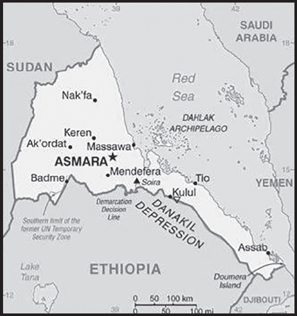
INTRODUCTION
Background: After independence from Italian colonial control in 1941 and 10 years of British administrative control, the UN established Eritrea as an autonomous region within the Ethiopian federation in 1952. Ethiopia’s full annexation of Eritrea as a province 10 years later sparked a violent 30-year conflict for independence that ended in 1991 with Eritrean fighters defeating government forces. Eritreans overwhelmingly approved independence in a 1993 referendum. ISAIAS Afwerki has been Eritrea’s only president since independence; his rule, particularly since 2001, has been characterized by highly autocratic and repressive actions. His government has created a highly militarized society by instituting an unpopular program of mandatory conscription into national service – divided between military and civilian service – of indefinite length. A two-and-a-half-year border war with Ethiopia that erupted in 1998 ended under UN auspices in December 2000. A subsequent 2007 Eritrea-Ethiopia Boundary Commission (EEBC) demarcation was rejected by Ethiopia. More than a decade of a tense “no peace, no war” stalemate ended in 2018 after the newly elected Ethiopian prime minister accepted the EEBC’s 2007 ruling, and the two countries signed declarations of peace and friendship. Following the July 2018 peace agreement with Ethiopia, Eritrean leaders engaged in intensive diplomacy around the Horn of Africa, bolstering regional peace, security, and cooperation, as well as brokering rapprochements between governments and opposition groups. In November 2018, the UN Security Council lifted an arms embargo that had been imposed on Eritrea since 2009, after the UN Somalia-Eritrea Monitoring Group reported they had not found evidence of Eritrean support in recent years for al-Shabaab. The country’s rapprochement with Ethiopia led to a resumption of economic ties, with increased air transport, trade, tourism, and port activities, until late 2020, but the economy remains agriculture-dependent, and Eritrea is still one of Africa’s poorest nations. Eritrea faced new international condemnation and US sanctions in mid-2021 for its participation in the war in Ethiopia’s Tigray Regional State, where Eritrean forces were found to have committed war crimes and crimes against humanity. As most Eritrean troops were departing northern Ethiopia in January 2023, ISAIAS began a series of diplomatic engagements aimed at bolstering Eritrea’s foreign partnerships and regional influence. Despite the country’s improved relations with its neighbors, ISAIAS has not let up on repression and conscription and militarization continue.
GEOGRAPHY
Location: Eastern Africa, bordering the Red Sea, between Djibouti and Sudan
Geographic coordinates: 15 00 N, 39 00 E
Map references: Africa
Area: total: 117,600 sq km
land: 101,000 sq km
water: 16,600 sq km
comparison ranking: total 101
Area - comparative: slightly smaller than Pennsylvania
Land boundaries: total: 1,840 km
border countries (3): Djibouti 125 km; Ethiopia 1,033 km; Sudan 682 km
Coastline: 2,234 km (mainland on Red Sea 1,151 km, islands in Red Sea 1,083 km)
Maritime claims: territorial sea: 12 nm
Climate: hot, dry desert strip along Red Sea coast; cooler and wetter in the central highlands (up to 61 cm of rainfall annually, heaviest June to September); semiarid in western hills and lowlands
Terrain: dominated by extension of Ethiopian north-south trending highlands, descending on the east to a coastal desert plain, on the northwest to hilly terrain and on the southwest to flat-to-rolling plains
Elevation: highest point: Soira 3,018 m
lowest point: near Kulul within the Danakil Depression -75 m
mean elevation: 853 m
Natural resources: gold, potash, zinc, copper, salt, possibly oil and natural gas, fish
Land use: agricultural land: 75.1% (2018 est.)
arable land: 6.8% (2018 est.)
permanent crops: 0% (2018 est.)
permanent pasture: 68.3% (2018 est.)
forest: 15.1% (2018 est.)
other: 9.8% (2018 est.)
Irrigated land: 210 sq km (2012)
Population distribution: density is highest in the center of the country in and around the cities of Asmara (capital) and Keren; smaller settlements exist in the north and south as shown in this population distribution map
Natural hazards: frequent droughts, rare earthquakes and volcanoes; locust swarms
volcanism: Dubbi (1,625 m), which last erupted in 1861, was the country’s only historically active volcano until Nabro (2,218 m) came to life on 12 June 2011
Geography - note: strategic geopolitical position along world’s busiest shipping lanes; Eritrea retained the entire coastline of Ethiopia along the Red Sea upon de jure independence from Ethiopia on 24 May 1993
PEOPLE AND SOCIETY
Population: 6,274,796 (2023 est.)
comparison ranking: 111
Nationality: noun: Eritrean(s)
adjective: Eritrean
Ethnic groups: Tigrinya 50%, Tigre 30%, Saho 4%, Afar 4%, Kunama 4%, Bilen 3%, Hedareb/Beja 2%, Nara 2%, Rashaida 1% (2021 est.)
note: data represent Eritrea’s nine recognized ethnic groups
Languages: Tigrinya (official), Arabic (official), English (official), Tigre, Kunama, Afar, other Cushitic languages
Religions: Eritrean Orthodox, Roman Catholic, Evangelical Lutheran, Sunni Muslim
Demographic profile: Eritrea is a persistently poor country that has made progress in some socioeconomic categories but not in others. Education and human capital formation are national priorities for facilitating economic development and eradicating poverty. To this end, Eritrea has made great strides in improving adult literacy – doubling the literacy rate over the last 20 years – in large part because of its successful adult education programs. The overall literacy rate was estimated to be more than 75% in 2018; more work needs to be done to raise female literacy and school attendance among nomadic and rural communities. Subsistence farming fails to meet the needs of Eritrea’s growing population because of repeated droughts, dwindling arable land, overgrazing, soil erosion, and a shortage of farmers due to conscription and displacement. The government’s emphasis on spending on defense over agriculture and its lack of foreign exchange to import food also contribute to food insecurity.
Eritrea has been a leading refugee source country since at least the 1960s, when its 30-year war for independence from Ethiopia began. Since gaining independence in 1993, Eritreans have continued migrating to Sudan, Ethiopia, Yemen, Egypt, or Israel because of a lack of basic human rights or political freedom, educational and job opportunities, or to seek asylum because of militarization. Eritrea’s large diaspora has been a source of vital remittances, funding its war for independence and providing 30% of the country’s GDP annually since it became independent.
In the last few years, Eritreans have increasingly been trafficked and held hostage by Bedouins in the Sinai Desert, where they are victims of organ harvesting, rape, extortion, and torture. Some Eritrean trafficking victims are kidnapped after being smuggled to Sudan or Ethiopia, while others are kidnapped from within or around refugee camps or crossing Eritrea’s borders. Eritreans composed approximately 90% of the conservatively estimated 25,000-30,000 victims of Sinai trafficking from 2009-2013, according to a 2013 consultancy firm report.
Age structure: 0-14 years: 36.27% (male 1,145,134/female 1,130,829)
15-64 years: 59.73% (male 1,842,953/female 1,904,677)
65 years and over: 4% (2023 est.) (male 100,158/female 151,045)
Dependency ratios: total dependency ratio: 77.9
youth dependency ratio: 70.8
elderly dependency ratio: 7.1
potential support ratio: 14 (2021 est.)
Median age: total: 20.3 years (2020)
male: 19.7 years
female: 20.8 years
comparison ranking: total 190
Population growth rate: 1.08% (2023 est.)
comparison ranking: 87
Birth rate: 26.72 births/1,000 population (2023 est.)
comparison ranking: 40
Death rate: 6.6 deaths/1,000 population (2023 est.)
comparison ranking: 131
Net migration rate: -9.38 migrant(s)/1,000 population (2023 est.)
comparison ranking: 221
Population distribution: density is highest in the center of the country in and around the cities of Asmara (capital) and Keren; smaller settlements exist in the north and south as shown in this population distribution map
Urbanization: urban population: 43.3% of total population (2023)
rate of urbanization: 3.67% annual rate of change (2020-25 est.)
Major urban areas - population: 1.073 million ASMARA (capital) (2023)
Sex ratio: at birth: 1.03 male(s)/female
0-14 years: 1.01 male(s)/female
15-64 years: 0.97 male(s)/female
65 years and over: 0.66 male(s)/female
total population: 0.97 male(s)/female (2023 est.)
Mother’s mean age at first birth: 21.3 years (2010 est.)
note: data represents median age at first birth among women 25-29
Maternal mortality ratio: 322 deaths/100,000 live births (2020 est.)
comparison ranking: 28
Infant mortality rate: total: 40.63 deaths/1,000 live births (2023 est.)
male: 47.45 deaths/1,000 live births
female: 33.62 deaths/1,000 live births
comparison ranking: total 30
Life expectancy at birth: total population: 67.19 years (2023 est.)
male: 64.56 years
female: 69.89 years
comparison ranking: total population 195
Total fertility rate: 3.5 children born/woman (2023 est.)
comparison ranking: 35
Gross reproduction rate: 1.73 (2023 est.)
Drinking water source: improved: urban: 73.2% of population
rural: 53.3% of population
total: 57.8% of population
unimproved: urban: 26.8% of population
rural: 46.7% of population
total: 42.2% of population (2015 est.)
Current health expenditure: 4.1% of GDP (2020)
Physicians density: 0.08 physicians/1,000 population (2020)
Hospital bed density: 0.7 beds/1,000 population (2011)
Sanitation facility access: improved: urban: 44.5% of population
rural: 7.3% of population
total: 15.7% of population
unimproved: urban: 55.5% of population
rural: 92.7% of population
total: 84.3% of population (2017 est.)
Major infectious diseases: degree of risk: high (2023)
food or waterborne diseases: bacterial diarrhea, hepatitis A, and typhoid fever
vectorborne diseases: malaria and dengue fever
Obesity - adult prevalence rate: 5% (2016)
comparison ranking: 183
Alcohol consumption per capita: total: 0.93 liters of pure alcohol (2019 est.)
beer: 0.42 liters of pure alcohol (2019 est.)
wine: 0 liters of pure alcohol (2019 est.)
spirits: 0 liters of pure alcohol (2019 est.)
other alcohols: 0.51 liters of pure alcohol (2019 est.)
comparison ranking: total 153
Tobacco use: total: 7.5% (2020 est.)
male: 14.7% (2020 est.)
female: 0.2% (2020 est.)
comparison ranking: total 153
Currently married women (ages 15-49): 52.3% (2023 est.)
Literacy: definition: age 15 and over can read and write
total population: 76.6%
male: 84.4%
female: 68.9% (2018)
School life expectancy (primary to tertiary education): total: 8 years
male: 8 years
female: 7 years (2015)
Youth unemployment rate (ages 15-24): total: 14.6% (2021 est.)
male: 13.1%
female: 16.4%
comparison ranking: total 121
ENVIRONMENT
Environment - current issues: deforestation; desertification; soil erosion; overgrazing
Environment - international agreements: party to: Biodiversity, Climate Change, Climate Change-Kyoto Protocol, Comprehensive Nuclear Test Ban, Desertification, Endangered Species, Hazardous Wastes, Ozone Layer Protection, Whaling
signed, but not ratified: Climate Change-Paris Agreement
Climate: hot, dry desert strip along Red Sea coast; cooler and wetter in the central highlands (up to 61 cm of rainfall annually, heaviest June to September); semiarid in western hills and lowlands
Land use: agricultural land: 75.1% (2018 est.)
arable land: 6.8% (2018 est.)
permanent crops: 0% (2018 est.)
permanent pasture: 68.3% (2018 est.)
forest: 15.1% (2018 est.)
other: 9.8% (2018 est.)
Urbanization: urban population: 43.3% of total population (2023)
rate of urbanization: 3.67% annual rate of change (2020-25 est.)
Air pollutants: particulate matter emissions: 22.74 micrograms per cubic meter (2019 est.)
carbon dioxide emissions: 0.71 megatons (2016 est.)
methane emissions: 4.48 megatons (2020 est.)
Waste and recycling: municipal solid waste generated annually: 726,957 tons (2011 est.)
Total water withdrawal: municipal: 30 million cubic meters (2020 est.)
industrial: 1 million cubic meters (2017 est.)
agricultural: 550 million cubic meters (2020 est.)
Total renewable water resources: 7.32 billion cubic meters (2020 est.)
GOVERNMENT
Country name: conventional long form: State of Eritrea
conventional short form: Eritrea
local long form: Hagere Ertra
local short form: Ertra
former: Eritrea Autonomous Region in Ethiopia
etymology: the country name derives from the ancient Greek appellation “Erythra Thalassa” meaning Red Sea, which is the major water body bordering the country
Government type: presidential republic
Capital: name: Asmara
geographic coordinates: 15 20 N, 38 56 E
time difference: UTC+3 (8 hours ahead of Washington, DC, during Standard Time)
etymology: the name means “they [women] made them unite,” which according to Tigrinya oral tradition refers to the women of the four clans in the Asmara area who persuaded their menfolk to unite and defeat their common enemy; the name has also been translated as “live in peace”
Administrative divisions: 6 regions (zobatat, singular - zoba); ‘Anseba, Debub (South), Debubawi K’eyyih Bahri (Southern Red Sea), Gash-Barka, Ma’ikel (Central), Semienawi K’eyyih Bahri (Northern Red Sea)
Independence: 24 May 1993 (from Ethiopia)
National holiday: Independence Day, 24 May (1991)
Constitution: history: ratified by the Constituent Assembly 23 May 1997 (never implemented)
amendments: proposed by the president of Eritrea or by assent of at least one half of the National Assembly membership; passage requires at least an initial three-quarters majority vote by the Assembly and, after one year, final passage by at least four-fifths majority vote by the Assembly
Legal system: mixed legal system of civil, customary, and Islamic religious law
International law organization participation: has not submitted an ICJ jurisdiction declaration; non-party state to the ICCt
Citizenship: citizenship by birth: no
citizenship by descent only: at least one parent must be a citizen of Eritrea
dual citizenship recognized: no
residency requirement for naturalization: 20 years
Suffrage: 18 years of age; universal
Executive branch: chief of state: President ISAIAS Afwerki (since 24 May 1993); note - the president is both chief of state and head of government and is head of the State Council and National Assembly
head of government: President ISAIAS Afwerki (since 8 June 1993)
cabinet: State Council appointed by the president
elections/appointments: president indirectly elected by the National Assembly for a 5-year term (eligible for a second term), according to the constitution; the only election held was on 24 May 1993, following independence from Ethiopia (next postponed indefinitely)
election results: ISAIAS Afwerki elected president by the transitional National Assembly; percent of National Assembly vote - ISAIAS Afwerki (PFDJ) 95%, other 5%
Legislative branch: description: unicameral National Assembly (Hagerawi Baito) (150 seats; 75 members directly elected by simple majority vote and 75 members indirectly elected by the ruling party; members serve 5-year terms)
elections: in May 1997, following the adoption of the new constitution, 75 members of the PFDJ Central Committee (the old Central Committee of the EPLF), 60 members of the 527-member Constituent Assembly, which had been established in 1997 to discuss and ratify the new constitution, and 15 representatives of Eritreans living abroad were formed into a Transitional National Assembly to serve as the country’s legislative body until countrywide elections to form a National Assembly were held; although only 75 of 150 members of the Transitional National Assembly were elected, the constitution stipulates that once past the transition stage, all members of the National Assembly will be elected by secret ballot of all eligible voters; National Assembly elections scheduled for December 2001 were postponed indefinitely due to the war with Ethiopia, and as of 2023, there was no sitting legislative body
election results: NA
Judicial branch: highest court(s): High Court (consists of 20 judges and organized into civil, commercial, criminal, labor, administrative, and customary sections)
judge selection and term of office: High Court judges appointed by the president
subordinate courts: regional/zonal courts; community courts; special courts; sharia courts (for issues dealing with Muslim marriage, inheritance, and family); military courts
Political parties and leaders: People’s Front for Democracy and Justice or PFDJ [ISAIAS Afwerki] (the only party recognized by the government)
International organization participation: ACP, AfDB, AU, COMESA, FAO, G-77, IAEA, IBRD, ICAO, ICC (NGOs), IDA, IFAD, IFC, IFRCS (observer), IGAD, ILO, IMF, IMO, Interpol, IOC, ISO (correspondent), ITU, ITUC (NGOs), LAS (observer), MIGA, NAM, OPCW, PCA, UN, UNCTAD, UNESCO, UNHRC, UNIDO, UNWTO, UPU, WCO, WFTU (NGOs), WHO, WIPO, WMO
Diplomatic representation in the US: chief of mission: Ambassador (vacant); Chargé d’Affaires Berhane Gebrehiwet SOLOMON (since 15 March 2011)
chancery: 1708 New Hampshire Avenue NW, Washington, DC 20009
telephone: [1] (202) 319-1991
FAX: [1] (202) 319-1304
email address and website:
embassyeritrea@embassyeritrea.org
https://us.embassyeritrea.org/
Diplomatic representation from the US: chief of mission: Ambassador (vacant); Chargé d’Affaires Leslie FRERIKSEN (since 18 July 2022)
embassy: 179 Alaa Street, Asmara
mailing address: 7170 Asmara Place, Washington DC 20521-7170
telephone: [291] (1) 12-00-04
FAX: [291] (1) 12-75-84
email address and website:
Flag description: red isosceles triangle (based on the hoist side) dividing the flag into two right triangles; the upper triangle is green, the lower one is blue; a gold wreath encircling a gold olive branch is centered on the hoist side of the red triangle; green stands for the country’s agriculture economy, red signifies the blood shed in the fight for freedom, and blue symbolizes the bounty of the sea; the wreath-olive branch symbol is similar to that on the first flag of Eritrea from 1952; the shape of the red triangle broadly mimics the shape of the country
note: one of several flags where a prominent component of the design reflects the shape of the country; other such flags are those of Bosnia and Herzegovina, Brazil, and Vanuatu
National symbol(s): camel; national colors: green, red, blue
National anthem: name: “Ertra, Ertra, Ertra” (Eritrea, Eritrea, Eritrea)
lyrics/music: SOLOMON Tsehaye Beraki/Isaac Abraham MEHAREZGI and ARON Tekle Tesfatsion
note: adopted 1993; upon independence from Ethiopia
National heritage: total World Heritage Sites: 1 (cultural)
selected World Heritage Site locales: Asmara: A Modernist African City
ECONOMY
Economic overview: largely agrarian economy with a significant mining sector; substantial fiscal surplus due to tight controls; high and vulnerable debts; increased Ethiopian trade and shared port usage decreasing prices; financial and economic data integrity challenges
Real GDP (purchasing power parity): $9.702 billion (2017 est.)
$8.953 billion (2016 est.)
$8.791 billion (2015 est.)
note: data are in 2017 dollars
comparison ranking: 164
Real GDP growth rate: 5% (2017 est.)
1.9% (2016 est.)
2.6% (2015 est.)
comparison ranking: 90
Real GDP per capita: $1,600 (2017 est.)
$1,500 (2016 est.)
$1,500 (2015 est.)
note: data are in 2017 dollars
comparison ranking: 217
GDP (official exchange rate)
$5.813 billion (2017 est.)
Inflation rate (consumer prices): 9% (2017 est.)
9% (2016 est.)
comparison ranking: 29
GDP - composition, by sector of origin
agriculture: 11.7% (2017 est.)
industry: 29.6% (2017 est.)
services: 58.7% (2017 est.)
comparison rankings: services 133; industry 79; agriculture 83
GDP - composition, by end use
household consumption: 80.9% (2017 est.)
government consumption: 24.3% (2017 est.)
investment in fixed capital: 6.4% (2017 est.)
investment in inventories: 0.1% (2017 est.)
exports of goods and services: 10.9% (2017 est.)
imports of goods and services: -22.5% (2017 est.)
Agricultural products: sorghum, milk, vegetables, barley, cereals, pulses nes, roots/tubers nes, wheat, millet, beef
Industries: food processing, beverages, clothing and textiles, light manufacturing, salt, cement
Industrial production growth rate: 5.4% (2017 est.)
comparison ranking: 83
Labor force: 1.675 million (2021 est.)
comparison ranking: 132
Labor force - by occupation: agriculture: 80%
industry: 20% (2004 est.)
Unemployment rate: 8.05% (2021 est.)
7.86% (2020 est.)
5.99% (2019 est.)
comparison ranking: 95
Youth unemployment rate (ages 15-24): total: 14.6% (2021 est.)
male: 13.1%
female: 16.4%
comparison ranking: total 121
Population below poverty line: 50% (2004 est.)
Budget: revenues: $633 million (2018 est.)
expenditures: $549 million (2018 est.)
Budget surplus (+) or deficit (-): -9.8% (of GDP) (2017 est.)
comparison ranking: 209
Public debt: 131.2% of GDP (2017 est.)
132.8% of GDP (2016 est.)
comparison ranking: 9
Taxes and other revenues: 34.9% (of GDP) (2017 est.)
comparison ranking: 20
Fiscal year: calendar year
Current account balance: -$137 million (2017 est.)
-$105 million (2016 est.)
comparison ranking: 95
Exports: $624.3 million (2017 est.)
$485.4 million (2016 est.)
comparison ranking: 187
Exports - partners: China 62%, South Korea 28.3% (2017)
Exports - commodities: zinc, copper, gold, clothing, stone grinders (2021)
Imports: $1.127 billion (2017 est.)
$1.048 billion (2016 est.)
comparison ranking: 185
Imports - partners: UAE 14.5%, China 13.2%, Saudi Arabia 13.2%, Italy 12.9%, Turkey 5.6%, South Africa 4.6% (2017)
Imports - commodities: machinery, petroleum products, food, manufactured goods
Reserves of foreign exchange and gold: $191,694,400 (31 December 2019 est.)
$163,033,700 (31 December 2018 est.)
$143,412,400 (31 December 2017 est.)
comparison ranking: 184
Debt - external: $792.7 million (31 December 2017 est.)
$875.6 million (31 December 2016 est.)
comparison ranking: 170
Exchange rates: nakfa (ERN) per US dollar -
Exchange rates: 15.075 (2021 est.)
15.075 (2020 est.)
15.075 (2019 est.)
15.075 (2018 est.)
15.075 (2017 est.)
ENERGY
Electricity access: population without electricity: 3 million (2020)
electrification - total population: 52.5% (2021)
electrification - urban areas: 75.6% (2019)
electrification - rural areas: 35.7% (2021)
Electricity: installed generating capacity: 228,000 kW (2020 est.)
consumption: 394.46 million kWh (2019 est.)
exports: 0 kWh (2019 est.)
imports: 0 kWh (2019 est.)
transmission/distribution losses: 61 million kWh (2019 est.)
comparison rankings: installed generating capacity 166; transmission/distribution losses 169; imports 178; exports 170; consumption 176
Electricity generation sources: fossil fuels: 93.8% of total installed capacity (2020 est.)
solar: 5.7% of total installed capacity (2020 est.)
wind: 0.5% of total installed capacity (2020 est.)
Petroleum: total petroleum production: 0 bbl/day (2021 est.)
refined petroleum consumption: 5,200 bbl/day (2019 est.)
Refined petroleum products - imports: 3,897 bbl/day (2015 est.)
comparison ranking: 179
Carbon dioxide emissions: 798,000 metric tonnes of CO2 (2019 est.)
from petroleum and other liquids: 798,000 metric tonnes of CO2 (2019 est.)
comparison ranking: total emissions 179
Energy consumption per capita: 3.217 million Btu/person (2019 est.)
comparison ranking: 182
COMMUNICATIONS
Telephones - fixed lines: total subscriptions: 66,000 (2021 est.)
subscriptions per 100 inhabitants: 2 (2021 est.)
comparison ranking: total subscriptions 147
Telephones - mobile cellular: total subscriptions: 1.8 million (2021 est.)
subscriptions per 100 inhabitants: 50 (2021 est.)
comparison ranking: total subscriptions 156
Telecommunication systems: general assessment: Eritrea’s telecom sector operates under a state-owned monopoly for fixed and mobile services; as a result of such restrictions on competition, the country has the least developed telecommunications market in Africa; mobile penetration stands at only about 20%, while fixed-line internet use barely registers; this is exacerbated by the very low use of computers, with only about 4% of households having a computer, and most of these being in the capital, Asmara; the 3G network continues to rollout which provides basic internet access to the majority of Eritreans; investment in telecom infrastructure is still required to improve the quality of services; the government has embarked on a work program to do exactly that, specifically aimed at extending services to remote areas, improving the quality of services, and ensuring that more telecoms infrastructure is supported by solar power to compensate for the poor state of the electricity network (2022)
domestic: fixed-line subscribership is less than 2 per 100 persons and mobile-cellular is just over 50 per 100 (2021)
international: country code - 291 (2019)
Broadcast media: government controls broadcast media with private ownership prohibited; 1 state-owned TV station; 2 state-owned radio networks; purchases of satellite dishes and subscriptions to international broadcast media are permitted (2023)
Internet country code: .er
Internet users: total: 792,000 (2021 est.)
percent of population: 22% (2021 est.)
comparison ranking: total 156
Broadband - fixed subscriptions: total: 5,000 (2020 est.)
subscriptions per 100 inhabitants: 0.1 (2020 est.)
comparison ranking: total 189
TRANSPORTATION
National air transport system: number of registered air carriers: 1 (2020)
inventory of registered aircraft operated by air carriers: 1
annual passenger traffic on registered air carriers: 102,729 (2018)
Civil aircraft registration country code prefix: E3
Airports: 13 (2021)
comparison ranking: total 152
Airports - with paved runways: 4
note: paved runways have a concrete or asphalt surface but not all have facilities for refueling, maintenance, or air traffic control; the length of a runway required for aircraft to safely operate depends on a number of factors including the type of aircraft, the takeoff weight (including passengers, cargo, and fuel), engine types, flap settings, landing speed, elevation of the airport, and average maximum daily air temperature; paved runways can reach a length of 5,000 m (16,000 ft.), but the “typical” length of a commercial airline runway is between 2,500-4,000 m (8,000-13,000 ft.)
Airports - with unpaved runways: 9
note: unpaved runways have a surface composition such as grass or packed earth and are most suited to the operation of light aircraft; unpaved runways are usually short, often less than 1,000 m (3,280 ft.) in length; airports with unpaved runways often lack facilities for refueling, maintenance, or air traffic control
Heliports: 1 (2021)
Railways: total: 306 km (2018)
narrow gauge: 306 km (2018) 0.950-m gauge
comparison ranking: total 122
Roadways: total: 16,000 km (2018)
paved: 1,600 km (2000)
unpaved: 14,400 km (2000)
comparison ranking: total 120
Merchant marine: total: 9 (2022)
by type: general cargo 4, oil tanker 1, other 4
comparison ranking: total 159
Ports and terminals: major seaport(s): Assab, Massawa
MILITARY AND SECURITY
Military and security forces: Eritrean Defense Forces (EDF): Eritrean Ground Forces, Eritrean Navy, Eritrean Air Force (includes Air Defense Force); Hizbawi Serawit (aka People’s Army or People’s Militia) (2023)
note: police are responsible for maintaining internal security, but the government sometimes used the armed forces, reserves, demobilized soldiers, or civilian militia to meet domestic as well as external security requirements; the armed forces have authority to arrest and detain civilians
Military expenditures: 10% of GDP (2019 est.)
10.2% of GDP (2018 est.)
10.3% of GDP (2017 est.)
10.4% of GDP (2016 est.)
10.6% of GDP (2015 est.)
comparison ranking: 1
Military and security service personnel strengths: limited available information; estimated 150,000-200,000 personnel (2023)
Military equipment inventories and acquisitions: the EDF inventory is comprised primarily of older Russian and Soviet-era systems; Eritrea was under a UN arms embargo from 2009 to 2018; from the 1990s to 2008, Russia was the leading supplier of arms to Eritrea, and in recent years, Eritrea has expressed interest in purchasing additional Russian equipment; in 2022, it reportedly received some UAVs from Russia (2023)
Military service age and obligation: Eritrea mandates military service for all citizens between the ages of 18 and 40; 18-month conscript service obligation, which includes 4-6 months of military training and 12 months of military or other national service (military service is most common); in practice, military and national service is often extended indefinitely; citizens up to the age of 55 eligible for recall during mobilization (2023)
note: as of 2020, women were estimated to make up as much as 30% of the Eritrean military
Military - note: the military’s primary responsibilities are external defense, border security, and providing the regime a vehicle for national cohesion; the Army is the dominant service; it is a large, conscript-based force and estimated to have more than 20 infantry divisions, including some that are mechanized, as well as a division of commandos/special forces; the Air Force has a small number of Soviet-era combat aircraft and helicopters, while the Navy maintains a limited number of coastal patrol vessels
since the country’s independence in 1991, the Eritrean military has participated in numerous conflicts, including the Hanish Island Crisis with Yemen (1995), the First Congo War (1996-1997), the Second Sudanese Civil War (1996-1998), the Eritrea-Ethiopia War (1998-2000), the Djiboutian-Eritrean border conflict (2008), and the Tigray conflict in Ethiopia (2020-2022); during the Tigray conflict, the Eritrean Defense Forces were accused of widespread human rights abuses including executions, rape, and torture of civilians within Ethiopia (2023)
TRANSNATIONAL ISSUES
Disputes - international: Eritrea and Ethiopia agreed to abide by 2002 Ethiopia-Eritrea Boundary Commission’s (EEBC) delimitation decision, but neither party responded to the revised line detailed in the November 2006 EEBC Demarcation Statement; Sudan accuses Eritrea of supporting eastern Sudanese rebel groups; in 2008, Eritrean troops moved across the border on Ras Doumera peninsula and occupied Doumera Island with undefined sovereignty in the Red Sea
Trafficking in persons: tier rating: Tier 3 — Eritrea does not fully meet the minimum standards for the elimination of trafficking and is not making significant efforts to do so; a government policy or pattern of human trafficking existed; the government continued to exploit its nationals in forced labor in its compulsory national service and citizen militia by forcing them to serve indefinitely or for arbitrary periods; the government did not demonstrate any efforts to address human trafficking (2022)
trafficking profile: human traffickers exploit domestic victims in Eritrea and abroad; National Service is mandatory at age 18 and may take a variety of forms, including military service and physical labor but also government office jobs and teaching; the 18-month limit on compulsory national service was suspended since the 1998-2000 Eritrean-Ethiopian border conflict, blocking the demobilization of most individuals who are forced to serve indefinitely under threats of detention, torture, or familial reprisal; Eritreans who flee the country, usually with the aim of reaching Europe, seek the help of paid smugglers and are vulnerable to trafficking when they cross the border clandestinely into Sudan and Ethiopia; Eritreans are subject to forced labor and sex trafficking mainly in Sudan, Ethiopia, and Libya (2022)