G
INTRODUCTION
Background: Gabon, a sparsely populated country known for its dense rainforests and vast petroleum reserves, is one of the most prosperous and stable countries in central Africa. Approximately 40 ethnic groups are represented, the largest of which is the Fang, a group that covers the northern third of Gabon and expands north into Equatorial Guinea and Cameroon. From about the early 1300s, various kingdoms emerged in and surrounding present-day Gabon, including the Kingdoms of Loango and Orungu. Because most early Bantu languages spoken in these kingdoms did not have a written form, historical traditions were passed on orally, resulting in much of Gabon’s early history being lost over time. Portuguese traders who arrived in the mid-1400s gave the area its name of Gabon. At that time, indigenous trade networks began to engage with European traders, exchanging goods such as ivory and wood. For a century beginning in the 1760s, trade came to focus mostly on enslaved people. While many groups in Gabon participated in the slave trade, the Fang were a notable exception. As the slave trade declined in the late 1800s, France colonized the country and directed a widespread extraction of Gabonese resources. Anti-colonial rhetoric by Gabon’s educated elites increased significantly in the early 1900s, but no widespread rebellion materialized. French decolonization following World War II led to the country’s independence in 1960.
Within a year of independence, the government changed from a parliamentary to a presidential system, and Leon M’BA won the first presidential election in 1961. El Hadj Omar BONGO Ondimba - one of the longest ruling heads of state in history - was M’BA’s vice president and assumed the presidency after M’BA’s death in 1967. BONGO went on to dominate the country’s political scene for four decades (1967-2009). In 1968, he declared Gabon a single-party state and created the Parti Democratique Gabonais (PDG), which remains the predominant party in Gabonese politics today. In the early 1990s, he reintroduced a multiparty system under a new constitution after he was confronted with growing political opposition. He was reelected by wide margins in 1995, 1998, 2002, and 2005 against a divided opposition and amidst allegations of fraud. Following President BONGO’s death in 2009, a new election brought his son, Ali BONGO Ondimba, to power. President Ali BONGO Ondimba was reelected in 2016 in a close election against a united opposition. Gabon’s Constitutional Court reviewed the contested election results and ruled in his favor. President Ali BONGO Ondimba won a third term in Gabon’s 26 August 2023 election, but he was overthrown in a military coup on 30 August 2023. Gen. Brice OLIGUI Nguema led a military group called the Committee for the Transition and Restoration of Institutions that arrested and detained President BONGO, canceled the election results, and dissolved state institutions. On 4 September 2023, Gen. OLIGUI was sworn in as transitional president of Gabon.
GEOGRAPHY
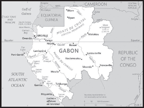
Location: Central Africa, bordering the Atlantic Ocean at the Equator, between Republic of the Congo and Equatorial Guinea
Geographic coordinates: 1 00 S, 11 45 E
Map references: Africa
Area: total: 267,667 sq km
land: 257,667 sq km
water: 10,000 sq km
comparison ranking: total 78
Area - comparative: slightly smaller than Colorado
Land boundaries: total: 3,261 km
border countries (3): Cameroon 349 km; Republic of the Congo 2,567 km; Equatorial Guinea 345 km
Coastline: 885 km
Maritime claims: territorial sea: 12 nm
contiguous zone: 24 nm
exclusive economic zone: 200 nm
Climate: tropical; always hot, humid
Terrain: narrow coastal plain; hilly interior; savanna in east and south
Elevation: highest point: Mont Bengoue 1,050 m
lowest point: Atlantic Ocean 0 m
mean elevation: 377 m
Natural resources: petroleum, natural gas, diamond, niobium, manganese, uranium, gold, timber, iron ore, hydropower
Land use: agricultural land: 19% (2018 est.)
arable land: 1.2% (2018 est.)
permanent crops: 0.6% (2018 est.)
permanent pasture: 17.2% (2018 est.)
forest: 81% (2018 est.)
other: 0% (2018 est.)
Irrigated land: 40 sq km (2012)
Major watersheds (area sq km): Atlantic Ocean drainage: Congo (3,730,881 sq km)
Major aquifers: Congo Basin
Population distribution: the relatively small population is spread in pockets throughout the country; the largest urban center is the capital of Libreville, located along the Atlantic coast in the northwest as shown in this population distribution map
Natural hazards: none
Geography - note: a small population and oil and mineral reserves have helped Gabon become one of Africa’s wealthier countries; in general, these circumstances have allowed the country to maintain and conserve its pristine rain forest and rich biodiversity
PEOPLE AND SOCIETY
Population: 2,397,368 (2023 est.)
comparison ranking: 146
Nationality: noun: Gabonese (singular and plural)
adjective: Gabonese
Ethnic groups: Gabonese-born 80.1% (includes Fang 23.2%, Shira-Punu/Vili 18.9%, Nzabi-Duma 11.3%, Mbede-Teke 6.9%, Myene 5%, Kota-Kele 4.9%, Okande-Tsogo 2.1%, Pygmy 0.3%, other 7.5%), Cameroonian 4.6%, Malian 2.4%, Beninese 2.1%, acquired Gabonese nationality 1.6%, Togolese 1.6%, Senegalese 1.1%, Congolese (Brazzaville) 1%, other 5.5% (includes Congolese (Kinshasa), Equatorial Guinean, Nigerian) (2012 est.)
Languages: French (official), Fang, Myene, Nzebi, Bapounou/Eschira, Bandjabi
Religions: Roman Catholic 42.3%, Protestant 12.3%, other Christian 27.4%, Muslim 9.8%, animist 0.6%, other 0.5%, none/no answer 7.1% (2012 est.)
Demographic profile: Gabon’s oil revenues have given it one of the highest per capita income levels in Sub-Saharan Africa, but the wealth is not evenly distributed and poverty is widespread. Unemployment is especially prevalent among the large youth population; more than 60% of the population is under the age of 25 as of 2020. With a fertility rate still averaging more than 3 children per woman, the youth population will continue to grow and further strain the mismatch between Gabon’s supply of jobs and the skills of its labor force.
Gabon has been a magnet to migrants from neighboring countries since the 1960s because of the discovery of oil, as well as the country’s political stability and timber, mineral, and natural gas resources. Nonetheless, income inequality and high unemployment have created slums in Libreville full of migrant workers from Senegal, Nigeria, Cameroon, Benin, Togo, and elsewhere in West Africa. In 2011, Gabon declared an end to refugee status for 9,500 remaining Congolese nationals to whom it had granted asylum during the Republic of the Congo’s civil war between 1997 and 2003. About 5,400 of these refugees received permits to reside in Gabon.
Age structure: 0-14 years: 35.04% (male 424,741/female 415,342)
15-64 years: 60.76% (male 765,729/female 690,931)
65 years and over: 4.2% (2023 est.) (male 50,920/female 49,705)
Dependency ratios: total dependency ratio: 67.6
youth dependency ratio: 61
elderly dependency ratio: 6.5
potential support ratio: 15.3 (2021 est.)
Median age: total: 21 years (2020)
male: 21.4 years
female: 20.6 years
comparison ranking: total 187
Population growth rate: 2.39% (2023 est.)
comparison ranking: 28
Birth rate: 25.89 births/1,000 population (2023 est.)
comparison ranking: 43
Death rate: 5.59 deaths/1,000 population (2023 est.)
comparison ranking: 176
Net migration rate: 3.59 migrant(s)/1,000 population (2023 est.)
comparison ranking: 33
Population distribution: the relatively small population is spread in pockets throughout the country; the largest urban center is the capital of Libreville, located along the Atlantic coast in the northwest as shown in this population distribution map
Urbanization: urban population: 91% of total population (2023)
rate of urbanization: 2.27% annual rate of change (2020-25 est.)
Major urban areas - population: 870,000 LIBREVILLE (capital) (2023)
Sex ratio: at birth: 1.03 male(s)/female
0-14 years: 1.02 male(s)/female
15-64 years: 1.11 male(s)/female
65 years and over: 1.02 male(s)/female
total population: 1.07 male(s)/female (2023 est.)
Mother’s mean age at first birth: 19.6 years (2012 est.)
note: data represents median age at first birth among women 20-49
Maternal mortality ratio: 227 deaths/100,000 live births (2020 est.)
comparison ranking: 40
Infant mortality rate: total: 27.7 deaths/1,000 live births (2023 est.)
male: 30.61 deaths/1,000 live births
female: 24.71 deaths/1,000 live births
comparison ranking: total 57
Life expectancy at birth: total population: 70.03 years (2023 est.)
male: 68.3 years
female: 71.81 years
comparison ranking: total population 175
Total fertility rate: 3.26 children born/woman (2023 est.)
comparison ranking: 42
Gross reproduction rate: 1.61 (2023 est.)
Contraceptive prevalence rate: 31.1% (2012)
Drinking water source: improved: urban: 97.2% of population
rural: 55.3% of population
total: 93.1% of population
unimproved: urban: 2.8% of population
rural: 44.7% of population
total: 6.9% of population (2020 est.)
Current health expenditure: 3.4% of GDP (2020)
Physicians density: 0.65 physicians/1,000 population (2018)
Hospital bed density: 6.3 beds/1,000 population
Sanitation facility access: improved: urban: 81.3% of population
rural: 55.1% of population
total: 78.7% of population
unimproved: urban: 18.7% of population
rural: 44.9% of population
total: 21.3% of population (2020 est.)
Major infectious diseases: degree of risk: very high (2023)
food or waterborne diseases: bacterial diarrhea, hepatitis A, and typhoid fever
vectorborne diseases: malaria and dengue fever
water contact diseases: schistosomiasis
animal contact diseases: rabies
Obesity - adult prevalence rate: 15% (2016)
comparison ranking: 127
Alcohol consumption per capita: total: 6.47 liters of pure alcohol (2019 est.)
beer: 5.31 liters of pure alcohol (2019 est.)
wine: 0.62 liters of pure alcohol (2019 est.)
spirits: 0.5 liters of pure alcohol (2019 est.)
other alcohols: 0.04 liters of pure alcohol (2019 est.)
comparison ranking: total 64
Children under the age of 5 years underweight: 6.4% (2019/20)
comparison ranking: 69
Currently married women (ages 15-49): 49.7% (2023 est.)
Education expenditures: 3.2% of GDP (2020 est.)
comparison ranking: 150
Literacy: definition: age 15 and over can read and write
total population: 85.5%
male: 86.2%
female: 84.7% (2021)
Youth unemployment rate (ages 15-24): total: 38.4% (2021 est.)
male: 33.7%
female: 44.4%
comparison ranking: total 18
ENVIRONMENT
Environment - current issues: deforestation (the forests that cover three-quarters of the country are threatened by excessive logging); burgeoning population exacerbating disposal of solid waste; oil industry contributing to water pollution; wildlife poaching
Environment - international agreements: party to: Biodiversity, Climate Change, Climate Change-Kyoto Protocol, Climate Change-Paris Agreement, Comprehensive Nuclear Test Ban, Desertification, Endangered Species, Hazardous Wastes, Law of the Sea, Marine Dumping-London Convention, Nuclear Test Ban, Ozone Layer Protection, Ship Pollution, Tropical Timber 2006, Wetlands, Whaling
signed, but not ratified: none of the selected agreements
Climate: tropical; always hot, humid
Land use: agricultural land: 19% (2018 est.)
arable land: 1.2% (2018 est.)
permanent crops: 0.6% (2018 est.)
permanent pasture: 17.2% (2018 est.)
forest: 81% (2018 est.)
other: 0% (2018 est.)
Urbanization: urban population: 91% of total population (2023)
rate of urbanization: 2.27% annual rate of change (2020-25 est.)
Revenue from forest resources: 2.6% of GDP (2018 est.)
comparison ranking: 26
Revenue from coal: 0% of GDP (2018 est.)
comparison ranking: 68
Air pollutants: particulate matter emissions: 26.29 micrograms per cubic meter (2019 est.)
carbon dioxide emissions: 5.32 megatons (2016 est.)
methane emissions: 1.13 megatons (2020 est.)
Waste and recycling: municipal solid waste generated annually: 238,102 tons (1995 est.)
Major watersheds (area sq km): Atlantic Ocean drainage: Congo (3,730,881 sq km)
Major aquifers: Congo Basin
Total water withdrawal: municipal: 80 million cubic meters (2020 est.)
industrial: 10 million cubic meters (2020 est.)
agricultural: 40 million cubic meters (2020 est.)
Total renewable water resources: 166 billion cubic meters (2020 est.)
GOVERNMENT
Country name: conventional long form: Gabonese Republic
conventional short form: Gabon
local long form: Republique Gabonaise
local short form: Gabon
etymology: name originates from the Portuguese word “gabao” meaning “cloak,” which is roughly the shape that the early explorers gave to the estuary of the Komo River by the capital of Libreville
Government type: presidential republic
Capital: name: Libreville
geographic coordinates: 0 23 N, 9 27 E
time difference: UTC+1 (6 hours ahead of Washington, DC, during Standard Time)
etymology: original site settled by freed slaves and the name means “free town” in French; named in imitation of Freetown, the capital of Sierra Leone
Administrative divisions: 9 provinces; Estuaire, Haut-Ogooue, Moyen-Ogooue, Ngounie, Nyanga, Ogooue-Ivindo, Ogooue-Lolo, Ogooue-Maritime, Woleu-Ntem
Independence: 17 August 1960 (from France)
National holiday: Independence Day, 17 August (1960)
Constitution: history: previous 1961; latest drafted May 1990, adopted 15 March 1991, promulgated 26 March 1991
amendments: proposed by the president of the republic, by the Council of Ministers, or by one third of either house of Parliament; passage requires Constitutional Court evaluation, at least two-thirds majority vote of two thirds of the Parliament membership convened in joint session, and approval in a referendum; constitutional articles on Gabon’s democratic form of government cannot be amended; amended several times, last in 2023 (presidential term reduced to 5 years and election reduced to a single vote)
Legal system: mixed legal system of French civil law and customary law
International law organization participation: has not submitted an ICJ jurisdiction declaration; accepts ICCt jurisdiction
Citizenship: citizenship by birth: no
citizenship by descent only: at least one parent must be a citizen of Gabon
dual citizenship recognized: no
residency requirement for naturalization: 10 years
Suffrage: 18 years of age; universal
Executive branch: chief of state: Transitional President Gen. Brice OLIGUI Nguema (since 4 September 2023); note - on 30 August 2023, Gen. Brice OLIGUI Nguema led a military group called the Committee for the Transition and Restoration of Institutions in a coup in which President Ali BONGO Ondimba was arrested and detained, election results were canceled, and state institutions dissolved; on 4 September 2023, Gen. OLIGUI was sworn in as transitional president
head of government: Interim Prime Minister Raymond Ndong SIMA (since 8 September 2023)
cabinet: formerly the Council of Ministers, appointed by the prime minister in consultation with the president
elections/appointments: formerly, the president directly elected by plurality vote for a 5-year term (no term limits); election last held on 26 August 2023; prime minister appointed by the president; note - on 30 August 2023, Gen. Brice OLIGUI Nguema led a military group called Committee for the Transition and Restoration of Institutions in a coup in which President Ali BONGO Ondimba was arrested and detained, election results were canceled, and state institutions dissolved; on 4 September 2023, OLIGUI was sworn in as transitional president; a general election is planned for August 2025
election results:
2016: Ali BONGO Ondimba reelected president; percent of vote - Ali BONGO Ondimba (PDG) 49.8%, Jean PING (UFC) 48.2%, other 2.0%
2009: Ali BONGO Ondimba elected president; percent of vote - Ali BONGO Ondimba (PDG) 41.7%, Andre MBA OBAME (independent) 25.9%, Pierre MAMBOUNDOU (UPG) 25.2%, Zacharie MYBOTO (UGDD) 3.9%, other 3.3%
Legislative branch: description:
Transitional Parliament (formerly the bicameral Parliament) consists of:
Senate (70 seats; members appointed by Transitional president; member term NA)
National Assembly (98 seats; members appointed by the Transitional president; member term NA)
note - all members represent legally recognized political parties or leading political figures, civil society, and defense and security forces
elections: on 11 September 2023, Transitional President Gen. Brice OLIGUI Nguema appointed 168 members to the Transitional Parliament; elections for a permanent legislature reportedly to follow 2-year transition
election results: all members of the Transitional Parliament appointed by the Transitional president
Judicial branch: highest court(s): Supreme Court (consists of 4 permanent specialized supreme courts - Supreme Court or Cour de Cassation, Administrative Supreme Court or Conseil d’Etat, Accounting Supreme Court or Cour des Comptes, Constitutional Court or Cour Constitutionnelle, and the non-permanent Court of State Security, initiated only for cases of high treason by the president and criminal activity by executive branch officials)
judge selection and term of office: appointment and tenure of Supreme, Administrative, Accounting, and State Security courts NA; Constitutional Court judges appointed - 3 by the national president, 3 by the president of the Senate, and 3 by the president of the National Assembly; judges serve single renewable 7-year terms
subordinate courts: Courts of Appeal; county courts; military courts
Political parties and leaders: Gabonese Democratic Party or PDG [Ali BONGO Ondimba]
Restoration of Republican Values or RV
The Democrats or LD [Guy NZOUBA-NDAMA]
Paul Mba Abessole
International organization participation: ACP, AfDB, AU (suspended), BDEAC, CEMAC, FAO, FZ, G-24, G-77, IAEA, IBRD, ICAO, ICCt, ICRM, IDA, IDB, IFAD, IFC, IFRCS, ILO, IMF, IMO, IMSO, Interpol, IOC, IOM, IPU, ISO, ITSO, ITU, ITUC (NGOs), MIGA, MINUSCA, NAM, OIC, OIF, OPCW, UN, UNCTAD, UNESCO, UNHRC, UNIDO, UNWTO, UPU, WCO, WHO, WIPO, WMO, WTO
Diplomatic representation in the US: chief of mission: Ambassador Noel Nelson MESSONE (12 December 2022)
chancery: 2034 20th Street NW, Suite 200, Washington, DC 20009
telephone: [1] (202) 797-1000
FAX: [1] (301) 332-0668
email address and website:
https://gabonembassyusa.org/en/
Diplomatic representation from the US: chief of mission: Ambassador (vacant); Chargé d’Affaires Ellen B. THORBURN (since 27 October 2022); note - also accredited to Sao Tome and Principe
embassy: Sabliere, B.P. 4000, Libreville
mailing address: 2270 Libreville Place, Washington, DC 20521-2270
telephone: [241] 011-45-71-00
FAX: [241] 011-45-71-05
email address and website:
Flag description: three equal horizontal bands of green (top), yellow, and blue; green represents the country’s forests and natural resources, gold represents the equator (which transects Gabon) as well as the sun, blue represents the sea
National symbol(s): black panther; national colors: green, yellow, blue
National anthem: name: “La Concorde” (The Concorde)
lyrics/music: Georges Aleka DAMAS
note: adopted 1960
National heritage: total World Heritage Sites: 2 (1 natural, 1 mixed)
selected World Heritage Site locales: Ecosystem and Relict Cultural Landscape of Lopé-Okanda (m); Ivindo National Park (n)
ECONOMY
Economic overview: natural resource-rich, upper-middle-income, Central African economy; sparsely populated but high urbanization; young labor force; oil, manganese, and rubber exporter; foreign investment dependent; data integrity issue on poverty and income
Real GDP (purchasing power parity): $32.34 billion (2021 est.)
$31.874 billion (2020 est.)
$32.471 billion (2019 est.)
note: data are in 2017 dollars
comparison ranking: 136
Real GDP growth rate: 1.46% (2021 est.)
-1.84% (2020 est.)
3.92% (2019 est.)
comparison ranking: 176
Real GDP per capita: $13,800 (2021 est.)
$13,900 (2020 est.)
$14,500 (2019 est.)
note: data are in 2017 dollars
comparison ranking: 119
GDP (official exchange rate): $16.064 billion (2019 est.)
Inflation rate (consumer prices): 1.18% (2020 est.)
2.46% (2019 est.)
4.75% (2018 est.)
comparison ranking: 196
Credit ratings:
Fitch rating: CCC (2020)
Moody’s rating: Caa1 (2018)
Standard & Poors rating: N/A (2016)
note: The year refers to the year in which the current credit rating was first obtained.
GDP - composition, by sector of origin: agriculture: 5% (2017 est.)
industry: 44.7% (2017 est.)
services: 50.4% (2017 est.)
comparison rankings: services 177; industry 19; agriculture 127
GDP - composition, by end use: household consumption: 37.6% (2017 est.)
government consumption: 14.1% (2017 est.)
investment in fixed capital: 29% (2017 est.)
investment in inventories: -0.6% (2016 est.)
exports of goods and services: 46.7% (2017 est.)
imports of goods and services: -26.8% (2017 est.)
Agricultural products: plantains, cassava, sugar cane, yams, taro, vegetables, maize, groundnuts, game meat, rubber
Industries: petroleum extraction and refining; manganese, gold; chemicals, ship repair, food and beverages, textiles, lumbering and plywood, cement
Industrial production growth rate: 3.2% (2021 est.)
comparison ranking: 122
Labor force: 718,400 (2021 est.)
comparison ranking: 153
Labor force - by occupation: agriculture: 64%
industry: 12%
services: 24% (2005 est.)
Unemployment rate: 22.26% (2021 est.)
21.97% (2020 est.)
20.74% (2019 est.)
comparison ranking: 16
Youth unemployment rate (ages 15-24): total: 38.4% (2021 est.)
male: 33.7%
female: 44.4%
comparison ranking: total 18
Population below poverty line: 33.4% (2017 est.)
Gini Index coefficient - distribution of family income: 38 (2017 est.)
comparison ranking: 71
Household income or consumption by percentage share: lowest 10%: 2.5%
highest 10%: 32.7% (2005)
Budget: revenues: $3.296 billion (2019 est.)
expenditures: $2.937 billion (2019 est.)
Budget surplus (+) or deficit (-): -1.9% (of GDP) (2017 est.)
comparison ranking: 101
Public debt: 62.7% of GDP (2017 est.)
64.2% of GDP (2016 est.)
comparison ranking: 76
Taxes and other revenues: 11.48% (of GDP) (2019 est.)
comparison ranking: 181
Fiscal year: calendar year
Current account balance: -$725 million (2017 est.)
-$1.389 billion (2016 est.)
comparison ranking: 128
Exports: $10.8 billion (2019 est.)
$9.533 billion (2018 est.)
$9.145 billion (2017 est.)
comparison ranking: 102
Exports - partners: China 63%, Singapore 5% (2019)
Exports - commodities: crude petroleum, manganese, lumber, veneer sheeting, refined petroleum (2021)
Imports: $5.02 billion (2019 est.)
$4.722 billion (2018 est.)
$4.749 billion (2017 est.)
comparison ranking: 143
Imports - partners: France 22%, China 17%, Belgium 6%, United States 6%, United Arab Emirates 5% (2019)
Imports - commodities: poultry meats, excavation machinery, packaged medicines, cars, rice (2019)
Reserves of foreign exchange and gold: $1.372 billion (31 December 2019 est.)
$1.321 billion (31 December 2018 est.)
$965.054 million (31 December 2017 est.)
comparison ranking: 140
Debt - external: $6.49 billion (31 December 2017 est.)
$5.321 billion (31 December 2016 est.)
comparison ranking: 126
Exchange rates: Cooperation Financiere en Afrique Centrale francs (XAF) per US dollar -
Exchange rates: 554.531 (2021 est.)
575.586 (2020 est.)
585.911 (2019 est.)
555.446 (2018 est.)
580.657 (2017 est.)
ENERGY
Electricity access: population without electricity: (2020) less than 1 million
electrification - total population: 91.8% (2021)
electrification - urban areas: 98.6% (2021)
electrification - rural areas: 26.7% (2021)
Electricity: installed generating capacity: 784,000 kW (2020 est.)
consumption: 3.134 billion kWh (2019 est.)
exports: 0 kWh (2019 est.)
imports: 511 million kWh (2019 est.)
transmission/distribution losses: 389 million kWh (2019 est.)
comparison rankings: installed generating capacity 138; transmission/distribution losses 134; imports 87; exports 128; consumption 138
Electricity generation sources: fossil fuels: 40.6% of total installed capacity (2020 est.)
solar: 0.1% of total installed capacity (2020 est.)
hydroelectricity: 59% of total installed capacity (2020 est.)
biomass and waste: 0.3% of total installed capacity (2020 est.)
Petroleum: total petroleum production: 175,000 bbl/day (2021 est.)
refined petroleum consumption: 14,400 bbl/day (2019 est.)
crude oil and lease condensate exports: 178,400 bbl/day (2018 est.)
crude oil and lease condensate imports: 0 bbl/day (2018 est.)
crude oil estimated reserves: 2 billion barrels (2021 est.)
Refined petroleum products - production: 16,580 bbl/day (2017 est.)
comparison ranking: 91
Refined petroleum products - exports: 4,662 bbl/day (2015 est.)
comparison ranking: 91
Refined petroleum products - imports: 10,680 bbl/day (2015 est.)
comparison ranking: 146
Natural gas: production: 319.102 million cubic meters (2019 est.)
consumption: 319.102 million cubic meters (2019 est.)
proven reserves: 25.995 billion cubic meters (2021 est.)
Carbon dioxide emissions: 2.651 million metric tonnes of CO2 (2019 est.)
from coal and metallurgical coke: 0 metric tonnes of CO2 (2019 est.)
from petroleum and other liquids: 2.025 million metric tonnes of CO2 (2019 est.)
from consumed natural gas: 626,000 metric tonnes of CO2 (2019 est.)
comparison ranking: total emissions 152
Energy consumption per capita: 26.786 million Btu/person (2019 est.)
comparison ranking: 127
COMMUNICATIONS
Telephones - fixed lines: total subscriptions: 31,708 (2021 est.)
subscriptions per 100 inhabitants: 1 (2021 est.)
comparison ranking: total subscriptions 166
Telephones - mobile cellular: total subscriptions: 3,144,609 (2021 est.)
subscriptions per 100 inhabitants: 134 (2021 est.)
comparison ranking: total subscriptions 140
Telecommunication systems: general assessment: the telecom market was liberalized in 1999 when the government awarded three mobile telephony licenses and two ISP licenses and established an independent regulatory authority; in contrast with the mobile market, Gabon’s fixed-line and internet sectors have remained underdeveloped due to a lack of competition and high prices; the country has sufficient international bandwidth on the SAT-3/WASC/SAFE submarine cable; the arrival of the ACE submarine cable, combined with progressing work on the CAB cable, has increased back haul capacity supporting mobile data traffic (2022)
domestic: fixed-line 1 per 100 subscriptions; mobile cellular subscriptions are 134 per 100 persons (2021)
international: country code - 241; landing points for the SAT-3/WASC, ACE and Libreville-Port Gentil Cable fiber-optic submarine cable that provides connectivity to Europe and West Africa; satellite earth stations - 3 Intelsat (Atlantic Ocean) (2019)
Broadcast media: state owns and operates 2 TV stations and 2 radio broadcast stations; a few private radio and TV stations; transmissions of at least 2 international broadcasters are accessible; satellite service subscriptions are available
Internet country code: .ga
Internet users: total: 1.656 million (2021 est.)
percent of population: 72% (2021 est.)
comparison ranking: total 142
Broadband - fixed subscriptions: total: 44,607 (2020 est.)
subscriptions per 100 inhabitants: 2 (2020 est.)
comparison ranking: total 144
TRANSPORTATION
National air transport system: number of registered air carriers: 3 (2020)
inventory of registered aircraft operated by air carriers: 8
Civil aircraft registration country code prefix: TR
Airports: 44 (2021)
comparison ranking: total 97
Airports - with paved runways: 14
note: paved runways have a concrete or asphalt surface but not all have facilities for refueling, maintenance, or air traffic control; the length of a runway required for aircraft to safely operate depends on a number of factors including the type of aircraft, the takeoff weight (including passengers, cargo, and fuel), engine types, flap settings, landing speed, elevation of the airport, and average maximum daily air temperature; paved runways can reach a length of 5,000 m (16,000 ft.), but the “typical” length of a commercial airline runway is between 2,500-4,000 m (8,000-13,000 ft.)
Airports - with unpaved runways: 30
note: unpaved runways have a surface composition such as grass or packed earth and are most suited to the operation of light aircraft; unpaved runways are usually short, often less than 1,000 m (3,280 ft.) in length; airports with unpaved runways often lack facilities for refueling, maintenance, or air traffic control
Pipelines: 807 km gas, 1,639 km oil, 3 km water (2013)
Railways: total: 649 km (2014)
standard gauge: 649 km (2014) 1.435-m gauge
comparison ranking: total 105
Roadways: total: 14,300 km (2001)
paved: 900 km (2001)
unpaved: 13,400 km (2001)
comparison ranking: total 126
Waterways: 1,600 km (2010) (310 km on Ogooue River)
comparison ranking: 51
Merchant marine: total: 71 (2022)
by type: bulk carrier 2, general cargo 19, oil tanker 20, other 30
comparison ranking: total 107
Ports and terminals: major seaport(s): Libreville, Owendo, Port-Gentil
oil terminal(s): Gamba, Lucina
MILITARY AND SECURITY
Military and security forces: Gabonese Armed Forces (Force Armées Gabonaise or FAG; aka Gabonese Defense and Security Forces): Land Forces (Army), National Navy, Air Force, National Gendarmerie (includes Coast Guard), Corps of Firemen; Republican Guard (2023)
note: the National Police Forces, under the Ministry of Interior, and the National Gendarmerie, under the Ministry of Defense, are responsible for law enforcement and public security; elements of the armed forces and the Republican Guard, an elite unit that protects the president under his direct authority, sometimes perform internal security functions
Military expenditures: 1.3% of GDP (2022 est.)
1.7% of GDP (2021 est.)
1.8% of GDP (2020 est.)
1.6% of GDP (2019 est.)
1.6% of GDP (2018 est.)
comparison ranking: 105
Military and security service personnel strengths: approximately 6,500 active-duty troops including the Republican Guard and Gendarmerie (2023)
Military equipment inventories and acquisitions: the Gabonese military is lightly armed with a mix of equipment from a variety of suppliers including Brazil, China, France, Germany, and South Africa (2023)
Military service age and obligation: 18-26 years of age for voluntary military service; no conscription (2023)
Military - note: the Gabonese military is a small and lightly-armed force that is responsible for both external and internal security; in August 2023, it seized control of the government in a coup; some members of the military attempted a failed coup in 2019; the Army’s core forces are the Republican Guard and an airborne infantry battalion, which are supported by several small regionally-based infantry units; the Gendarmerie has regionally-based “legions,” as well as mobile forces, a national parks security unit, and a special intervention group; the Air Force has a small number of older French-made fighter aircraft and some combat helicopters, also mostly of French origin; the Navy has a small force of patrol boats (2023)
SPACE
Space agency/agencies: Gabonese Studies and Space Observations Agency (Agence Gabonaise d’Etudes et d’Observations Spatiales or AGEOS; established 2015) (2023)
Space program overview: has a small space program focused on the acquisition, processing, analysis, and furnishing of data from foreign remote sensing (RS) satellites for environmental management, mapping, natural resources, land use planning, and maritime surveillance, as well as research and innovation; has relationships with Brazil, China, the European Space Agency (ESA) and its member states (particularly France), Kenya, Niger, Rwanda, South Africa, and the US; shares RS data with neighboring countries (2023)
note: further details about the key activities, programs, and milestones of the country’s space program, as well as government spending estimates on the space sector, appear in Appendix S
TRANSNATIONAL ISSUES
Disputes - international: dispute with Equatorial Guinea over Mbane Island and lesser islands in the Corisco Bay submitted to ICJ in 2016
Trafficking in persons: tier rating: Tier 2 Watch List — Gabon does not fully meet the minimum standards for the elimination of trafficking but is making significant efforts to do so; officials increased funding and capacity at an NGO-run shelter for victims, and also increased prosecutions and convictions of alleged traffickers; however, the government did not demonstrate overall increasing efforts, compared to the previous year, to expand its anti-trafficking capacity; authorities did not report any referrals of victims to services and did not report efforts to identify, protect, or provide justice for adult victims—potential efforts that have been inadequate for several years; for the fourth consecutive year, the government did not adopt its anti-trafficking National Action Plan and lacked inter-ministerial coordination; officials did not report investigating allegations of judicial corruption related to trafficking crimes; therefore, Gabon remained on Tier 2 Watch List for the second consecutive year (2023)
trafficking profile: human traffickers exploit domestic and foreign victims in Gabon, as well as victims from Gabon abroad; Gabon is a primary destination and transit country for West and Central African men, women, and children subjected to forced labor and sex trafficking; poverty continues to represent a key risk factor in forced labor and sex trafficking; girls are exploited in forced labor in domestic service, markets, or roadside restaurants, and boys are forced to work as street vendors, mechanics, and laborers in the fishing sector; West African women are coerced into domestic servitude or commercial sex within Gabon; criminals may exploit children in illegal gold mines and wildlife trafficking; Gabonese labor recruiters associated with large agricultural firms exploit English-speaking Cameroonians displaced by violence and insecurity in Cameroon’s Northwest and Southwest regions, forcing some Cameroonians to work on rubber and palm oil plantations in northern Gabon; West African traffickers reportedly exploit children from other countries to work in markets and urban centers in Gabon; smugglers who assist foreign adults migrating to or through Gabon subject them to forced labor or commercial sex; some families willingly give children to intermediaries promising education or employment who instead subject the children to forced labor; women are exploited in sex trafficking at roadside bars, and brothel owners reportedly conduct child sex trafficking; traffickers often operate outside the capital to avoid detection and take advantage of Gabon’s porous borders and unguarded beaches to import victims by car or boat (2023)
INTRODUCTION
Background: In the 10th century, Muslim merchants established some of The Gambia’s earliest large settlements as trans-Saharan trade hubs. These settlements eventually grew into major export centers sending slaves, gold, and ivory across the Sahara. Between the 16th and 17th centuries, European colonial powers began establishing trade with The Gambia. In 1664, the United Kingdom established a colony in The Gambia focused on exporting enslaved people across the Atlantic. During the roughly 300 years of the trans-Atlantic slave trade, the UK and other European powers may have exported as many as 3 million people from The Gambia.
The Gambia gained its independence from the UK in 1965. Geographically surrounded by Senegal, it formed the short-lived confederation of Senegambia between 1982 and 1989. In 1994, Yahya JAMMEH led a military coup overthrowing the president and banning political activity. He subsequently won every presidential election until 2016, when he lost to Adama BARROW, who headed an opposition coalition during free and fair elections. BARROW won reelection in December 2021. The Gambia is the only member of the Economic Community of West African States that does not have presidential term limits. Since the 2016 election, The Gambia and the US have enjoyed improved relations. US assistance to the country has supported military education and training programs, capacity building, and democracy-strengthening activities.
GEOGRAPHY
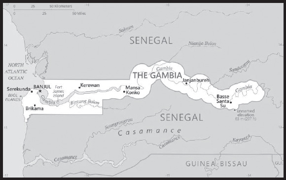
Location: Western Africa, bordering the North Atlantic Ocean and Senegal
Geographic coordinates: 13 28 N, 16 34 W
Map references: Africa
Area: total: 11,300 sq km
land: 10,120 sq km
water: 1,180 sq km
comparison ranking: total 165
Area - comparative: slightly less than twice the size of Delaware
Land boundaries: total: 749 km
border countries (1): Senegal 749 km
Coastline: 80 km
Maritime claims: territorial sea: 12 nm
contiguous zone: 18 nm
continental shelf: extent not specified
exclusive fishing zone: 200 nm
Climate: tropical; hot, rainy season (June to November); cooler, dry season (November to May)
Terrain: flood plain of the Gambia River flanked by some low hills
Elevation: highest point: unnamed elevation 63 m; 3 km southeast of the town of Sabi
lowest point: Atlantic Ocean 0 m
mean elevation: 34 m
Natural resources: fish, clay, silica sand, titanium (rutile and ilmenite), tin, zircon
Land use: agricultural land: 56.1% (2018 est.)
arable land: 41% (2018 est.)
permanent crops: 0.5% (2018 est.)
permanent pasture: 14.6% (2018 est.)
forest: 43.9% (2018 est.)
other: 0% (2018 est.)
Irrigated land: 50 sq km (2012)
Major rivers (by length in km): Gambia river mouth (shared with Senegal and Guinea [s]) - 1,094 km
note – [s] after country name indicates river source; [m] after country name indicates river mouth
Major aquifers: Senegalo-Mauritanian Basin
Population distribution: settlements are found scattered along the Gambia River; the largest communities, including the capital of Banjul, and the country’s largest city, Serekunda, are found at the mouth of the Gambia River along the Atlantic coast as shown in this population distribution map
Natural hazards: droughts
Geography - note: almost an enclave of Senegal; smallest country on the African mainland
PEOPLE AND SOCIETY
Population: 2,468,569 (2023 est.)
comparison ranking: 144
Nationality: noun: Gambian(s)
adjective: Gambian
Ethnic groups: Mandinka/Jahanka 33.3%, Fulani/Tukulur/Lorobo 18.2%, Wolof 12.9%, Jola/Karoninka 11%, Serahuleh 7.2%, Serer 3.5%, other 4%, non-Gambian 9.9% (2019-20 est.)
Languages: English (official), Mandinka, Wolof, Fula, other indigenous vernaculars
Religions: Muslim 96.4%, Christian 3.5%, other or none 0.1% (2019-20 est.)
Demographic profile: The Gambia’s youthful age structure – approximately 55% of the population is under the age of 25 as of 2021 – is likely to persist because the country’s total fertility rate remains strong at nearly 4 children per woman. The overall literacy rate is around 50%, and is significantly lower for women than for men. At least 70% of the populace are farmers who are reliant on rain-fed agriculture and cannot afford improved seeds and fertilizers. Crop failures caused by droughts between 2011 and 2013 increased poverty, food shortages, and malnutrition.
The Gambia is a source country for migrants and a transit and destination country for migrants and refugees. Since the 1980s, economic deterioration, drought, and high unemployment, especially among youths, have driven both domestic migration (largely urban) and migration abroad (legal and illegal). Emigrants are largely skilled workers, including doctors and nurses, and provide a significant amount of remittances. The top receiving countries for Gambian emigrants are Spain, the US, Nigeria, Senegal, and the UK. While the Gambia and Spain do not share historic, cultural, or trade ties, rural Gambians have migrated to Spain in large numbers because of its proximity and the availability of jobs in its underground economy (this flow slowed following the onset of Spain’s late 2007 economic crisis).
The Gambia’s role as a host country to refugees is a result of wars in several of its neighboring West African countries. Since 2006, refugees from the Casamance conflict in Senegal have replaced their pattern of flight and return with permanent settlement in The Gambia, often moving in with relatives along the Senegal-Gambia border. The strain of providing for about 7,400 Casamance refugees increased poverty among Gambian villagers. The number of refugees decreased to around 3,500 by 2022.
Age structure: 0-14 years: 38.86% (male 484,113/female 475,134)
15-64 years: 57.57% (male 700,049/female 721,057)
65 years and over: 3.57% (2023 est.) (male 38,954/female 49,262)
Dependency ratios: total dependency ratio: 85
youth dependency ratio: 80.5
elderly dependency ratio: 4.5
potential support ratio: 22.2 (2021 est.)
Median age: total: 21.8 years (2020)
male: 21.5 years
female: 22.2 years
comparison ranking: total 183
Population growth rate: 2.23% (2023 est.)
comparison ranking: 33
Birth rate: 28.03 births/1,000 population (2023 est.)
comparison ranking: 34
Death rate: 5.71 deaths/1,000 population (2023 est.)
comparison ranking: 170
Net migration rate: -0.04 migrant(s)/1,000 population (2023 est.)
comparison ranking: 98
Population distribution: settlements are found scattered along the Gambia River; the largest communities, including the capital of Banjul, and the country’s largest city, Serekunda, are found at the mouth of the Gambia River along the Atlantic coast as shown in this population distribution map
Urbanization: urban population: 64.5% of total population (2023)
rate of urbanization: 3.75% annual rate of change (2020-25 est.)
Major urban areas - population: 481,000 BANJUL (capital) (2023)
note: includes the local government areas of Banjul and Kanifing
Sex ratio: at birth: 1.03 male(s)/female
0-14 years: 1.02 male(s)/female
15-64 years: 0.97 male(s)/female
65 years and over: 0.79 male(s)/female
total population: 0.98 male(s)/female (2023 est.)
Mother’s mean age at first birth: 20.7 years (2019/20 est.)
note: data represents median age at first birth among women 25-49
Maternal mortality ratio: 458 deaths/100,000 live births (2020 est.)
comparison ranking: 17
Infant mortality rate: total: 36.44 deaths/1,000 live births (2023 est.)
male: 39.92 deaths/1,000 live births
female: 32.86 deaths/1,000 live births
comparison ranking: total 38
Life expectancy at birth: total population: 67.98 years (2023 est.)
male: 66.26 years
female: 69.75 years
comparison ranking: total population 188
Total fertility rate: 3.66 children born/woman (2023 est.)
comparison ranking: 32
Gross reproduction rate: 1.8 (2023 est.)
Contraceptive prevalence rate: 18.9% (2019/20)
Drinking water source: improved: urban: 91.8% of population
rural: 85.7% of population
total: 89.5% of population
unimproved: urban: 8.2% of population
rural: 14.3% of population
total: 10.5% of population (2020 est.)
Current health expenditure: 2.6% of GDP (2020)
Physicians density: 0.08 physicians/1,000 population (2020)
Hospital bed density: 1.1 beds/1,000 population (2011)
Sanitation facility access: improved: urban: 75.8% of population
rural: 33.6% of population
total: 60% of population
unimproved: urban: 24.2% of population
rural: 66.4% of population
total: 40% of population (2020 est.)
Major infectious diseases: degree of risk: very high (2023)
food or waterborne diseases: bacterial and protozoal diarrhea, hepatitis A, and typhoid fever
vectorborne diseases: malaria and dengue fever
water contact diseases: schistosomiasis
animal contact diseases: rabies
respiratory diseases: meningococcal meningitis
Obesity - adult prevalence rate: 10.3% (2016)
comparison ranking: 138
Alcohol consumption per capita: total: 2.67 liters of pure alcohol (2019 est.)
beer: 0.21 liters of pure alcohol (2019 est.)
wine: 0 liters of pure alcohol (2019 est.)
spirits: 0.02 liters of pure alcohol (2019 est.)
other alcohols: 2.44 liters of pure alcohol (2019 est.)
comparison ranking: total 121
Tobacco use: total: 11.1% (2020 est.)
male: 21.4% (2020 est.)
female: 0.8% (2020 est.)
comparison ranking: total 130
Children under the age of 5 years underweight: 11.6% (2019/20)
comparison ranking: 50
Currently married women (ages 15-49): 60.9% (2023 est.)
Child marriage: women married by age 15: 5.6%
women married by age 18: 23.1%
men married by age 18: 0.2% (2020 est.)
Education expenditures: 2.8% of GDP (2020 est.)
comparison ranking: 166
Literacy: definition: age 15 and over can read and write
total population: 58.1%
male: 65.2%
female: 51.2% (2021)
Youth unemployment rate (ages 15-24): total: 15.5% (2021 est.)
male: 11.4%
female: 20.5%
comparison ranking: total 114
ENVIRONMENT
Environment - current issues: deforestation due to slash-and-burn agriculture; desertification; water pollution; water-borne diseases
Environment - international agreements: party to: Biodiversity, Climate Change, Climate Change-Kyoto Protocol, Climate Change-Paris Agreement, Desertification, Endangered Species, Hazardous Wastes, Law of the Sea, Nuclear Test Ban, Ozone Layer Protection, Ship Pollution, Wetlands, Whaling
signed, but not ratified: Comprehensive Nuclear Test Ban
Climate: tropical; hot, rainy season (June to November); cooler, dry season (November to May)
Land use: agricultural land: 56.1% (2018 est.)
arable land: 41% (2018 est.)
permanent crops: 0.5% (2018 est.)
permanent pasture: 14.6% (2018 est.)
forest: 43.9% (2018 est.)
other: 0% (2018 est.)
Urbanization: urban population: 64.5% of total population (2023)
rate of urbanization: 3.75% annual rate of change (2020-25 est.)
Revenue from forest resources: 2.47% of GDP (2018 est.)
comparison ranking: 28
Revenue from coal: 0% of GDP (2018 est.)
comparison ranking: 53
Air pollutants: particulate matter emissions: 39.1 micrograms per cubic meter (2019 est.)
carbon dioxide emissions: 0.53 megatons (2016 est.)
methane emissions: 1.96 megatons (2020 est.)
Waste and recycling: municipal solid waste generated annually: 193,441 tons (2002 est.)
Major rivers (by length in km): Gambia river mouth (shared with Senegal and Guinea [s]) - 1,094 km
note – [s] after country name indicates river source; [m] after country name indicates river mouth
Major aquifers: Senegalo-Mauritanian Basin
Total water withdrawal: municipal: 40 million cubic meters (2020 est.)
industrial: 20 million cubic meters (2020 est.)
agricultural: 40 million cubic meters (2020 est.)
Total renewable water resources: 8 billion cubic meters (2020 est.)
GOVERNMENT
Country name: conventional long form: Republic of The Gambia
conventional short form: The Gambia
etymology: named for the Gambia River that flows through the heart of the country
Government type: presidential republic
Capital: name: Banjul
geographic coordinates: 13 27 N, 16 34 W
time difference: UTC 0 (5 hours ahead of Washington, DC, during Standard Time)
etymology: Banjul is located on Saint Mary’s Island at the mouth of the Gambia River; the Mandinka used to gather fibrous plants on the island for the manufacture of ropes; “bang julo” is Mandinka for “rope fiber”; mispronunciation over time caused the term became the word Banjul
Administrative divisions: 5 regions, 1 city*, and 1 municipality**; Banjul*, Central River, Kanifing**, Lower River, North Bank, Upper River, West Coast
Independence: 18 February 1965 (from the UK)
National holiday: Independence Day, 18 February (1965)
Constitution: history: previous 1965 (Independence Act), 1970; latest adopted 8 April 1996, approved by referendum 8 August 1996, effective 16 January 1997; note - in early 2018, the “Constitutional Review Commission,” was established to draft and assist in instituting a new constitution; a second draft completed in March 2020 was rejected by the National Assembly in September; the president announced in January 2022 government plans to draft a new constitution
amendments: proposed by the National Assembly; passage requires at least three-fourths majority vote by the Assembly membership in each of several readings and approval by the president of the republic; a referendum is required for amendments affecting national sovereignty, fundamental rights and freedoms, government structures and authorities, taxation, and public funding; passage by referendum requires participation of at least 50% of eligible voters and approval by at least 75% of votes cast; amended 2001, 2004, 2018
Legal system: mixed legal system of English common law, Islamic law, and customary law
International law organization participation: accepts compulsory ICJ jurisdiction with reservations; accepts ICCt jurisdiction
Citizenship: citizenship by birth: yes
citizenship by descent only: yes
dual citizenship recognized: no
residency requirement for naturalization: 5 years
Suffrage: 18 years of age; universal
Executive branch: chief of state: President Adama BARROW (since 19 January 2022); Vice President Isatou TOURAY (since 15 March 2019); note - the president is both chief of state and head of government
head of government: President Adama BARROW (since 19 January 2022); Vice President Isatou TOURAY (since 15 March 2019)
cabinet: Cabinet appointed by the president
elections/appointments: president directly elected by simple majority popular vote for a 5-year term (no term limits); election last held on 4 December 2021 (next to be held in 2026); vice president appointed by the president
election results:
2021: Adama BARROW reelected president; percent of vote - Adama BARROW (NPP) 53.2%, Ousainou DARBOE (UDP) 27.7%, Mamma KANDEH (GDC) 12.3%, other 6.8%
2016: Adama BARROW elected president; percent of vote - Adama BARROW (Coalition 2016) 43.3%, Yahya JAMMEH (APRC) 39.6%, Mamma KANDEH (GDC) 17.1%
Legislative branch: description: unicameral National Assembly (58 seats; 53 members directly elected in single-seat constituencies by simple majority vote and 5 appointed by the president; members serve 5-year terms)
elections: last held on 9 April 2022 (next to be held in 2027)
election results: percent of vote by party - NPP 33.9%, UDP 28.3%, independent 22.6%, NRP 7.5%, PDOIS 3.7%, APRL 3.7%; seats by party - NPP 18, UDP 15, independent 12, NRP 4, APRL 2, PDOIS 2; composition - men 52, women 6, percent of women 10.3%
Judicial branch: highest court(s): Supreme Court of The Gambia (consists of the chief justice and 6 justices; court sessions held with 5 justices)
judge selection and term of office: justices appointed by the president after consultation with the Judicial Service Commission, a 6-member independent body of high-level judicial officials, a presidential appointee, and a National Assembly appointee; justices appointed for life or until mandatory retirement at age 75
subordinate courts: Court of Appeal; High Court; Special Criminal Court; Khadis or Muslim courts; district tribunals; magistrates courts; cadi courts
Political parties and leaders: Alliance for Patriotic Reorientation and Construction or APRC [Fabakary JATTA]
Coalition 2016 [collective leadership] (electoral coalition includes UDP, PDOIS, NRP, GMC, GDC, PPP, and GPDP)
Gambia Democratic Congress or GDC [Mama KANDEH]
Gambia Moral Congress or GMC [Mai FATTY]
Gambia Party for Democracy and Progress or GPDP [Sarja JARJOU]
National Convention Party or NCP [Yaya SANYANG and Majanko SAMUSA (both claiming leadership)]
National Democratic Action Movement or NDAM [Lamin Yaa JUARA]
National People’s Party or NPP [Adama BARROW]
National Reconciliation Party or NRP [Hamat BAH]
People’s Democratic Organization for Independence and Socialism or PDOIS [Halifa SALLAH]
People’s Progressive Party or PPP [Yaya CEESAY)]
United Democratic Party or UDP [Ousainou DARBOE]
International organization participation: ACP, AfDB, AU, ECOWAS, FAO, G-77, IBRD, ICAO, ICCt, ICRM, IDA, IDB, IFAD, IFC, IFRCS, ILO, IMF, IMO, Interpol, IOC, IOM, IPU, ISO (correspondent), ITSO, ITU, ITUC (NGOs), MIGA, MINUSMA, NAM, OIC, OPCW, UN, UNAMID, UNCTAD, UNESCO, UNHRC, UNIDO, UNISFA, UNMIL, UNOCI, UNWTO, UPU, WCO, WFTU (NGOs), WHO, WIPO, WMO, WTO
Diplomatic representation in the US: chief of mission: Ambassador Momodou Lamin BAH (12 December 2022)
chancery: 5630 16th Street NW, Washington, DC 20011
telephone: [1] (202) 785-1399; [1] (202) 785-1428
FAX: [1] (202) 785-1430
email address and website:
https://www.gambiaembassydc.us/home
Diplomatic representation from the US: chief of mission: Ambassador Sharon L. CROMER (since 18 March 2022)
embassy: Kairaba Avenue, Fajara, P.M.B. 19, Banjul
mailing address: 2070 Banjul Place, Washington DC 20521-2070
telephone: [220] 439-2856
FAX: [220] 439-2475
email address and website:
Flag description: three equal horizontal bands of red (top), blue with white edges, and green; red stands for the sun and the savannah, blue represents the Gambia River, and green symbolizes forests and agriculture; the white stripes denote unity and peace
National symbol(s): lion; national colors: red, blue, green, white
National anthem: name: “For The Gambia, Our Homeland”
lyrics/music: Virginia Julie HOWE/adapted by Jeremy Frederick HOWE
note: adopted 1965; the music is an adaptation of the traditional Mandinka song “Foday Kaba Dumbuya”
National heritage: total World Heritage Sites: 2 (both cultural)
selected World Heritage Site locales: Kunta Kinteh Island and Related Sites; Stone Circles of Senegambia
ECONOMY
Economic overview: small West African economy; COVID-19 reversed robust growth trends; good fiscal management; substantial foreign direct investment and remittances; G20 Debt Service Suspension Initiative participant; widespread poverty; increasing Chinese relations
Real GDP (purchasing power parity): $5.482 billion (2021 est.)
$5.258 billion (2020 est.)
$5.227 billion (2019 est.)
note: data are in 2017 dollars
comparison ranking: 176
Real GDP growth rate: 4.27% (2021 est.)
0.59% (2020 est.)
6.22% (2019 est.)
comparison ranking: 110
Real GDP per capita: $2,100 (2021 est.)
$2,000 (2020 est.)
$2,100 (2019 est.)
note: data are in 2017 dollars
comparison ranking: 209
GDP (official exchange rate): $1.746 billion (2019 est.)
Inflation rate (consumer prices): 7.37% (2021 est.)
5.93% (2020 est.)
7.12% (2019 est.)
comparison ranking: 40
GDP - composition, by sector of origin: agriculture: 20.4% (2017 est.)
industry: 14.2% (2017 est.)
services: 65.4% (2017 est.)
comparison rankings: services 94; industry 186; agriculture 45
GDP - composition, by end use: household consumption: 90.7% (2017 est.)
government consumption: 12% (2017 est.)
investment in fixed capital: 19.2% (2017 est.)
investment in inventories: -2.7% (2017 est.)
exports of goods and services: 20.8% (2017 est.)
imports of goods and services: -40% (2017 est.)
Agricultural products: groundnuts, milk, oil palm fruit, millet, sorghum, rice, maize, vegetables, cassava, fruit
Industries: peanuts, fish, hides, tourism, beverages, agricultural machinery assembly, woodworking, metalworking, clothing
Industrial production growth rate: 10.4% (2021 est.)
comparison ranking: 26
Labor force: 856,100 (2021 est.)
comparison ranking: 150
Labor force - by occupation: agriculture: 75%
industry: 19%
services: 6% (1996 est.)
Unemployment rate: 11.21% (2021 est.)
11.08% (2020 est.)
9.5% (2019 est.)
comparison ranking: 62
Youth unemployment rate (ages 15-24): total: 15.5% (2021 est.)
male: 11.4%
female: 20.5%
comparison ranking: total 114
Population below poverty line: 48.6% (2015 est.)
Gini Index coefficient - distribution of family income: 35.9 (2015 est.)
comparison ranking: 90
Household income or consumption by percentage share: lowest 10%: 2%
highest 10%: 36.9% (2003)
Budget: revenues: $252 million (2018 est.)
expenditures: $353 million (2018 est.)
Budget surplus (+) or deficit (-): -2.6% (of GDP) (2017 est.)
comparison ranking: 115
Public debt: 88% of GDP (2017 est.)
82.3% of GDP (2016 est.)
comparison ranking: 35
Taxes and other revenues: 20.3% (of GDP) (2017 est.)
comparison ranking: 88
Fiscal year: calendar year
Current account balance: -$94.081 million (2021 est.)
-$86.553 million (2020 est.)
-$37.078 million (2019 est.)
comparison ranking: 91
Exports: $135.448 million (2021 est.) note: data are in current year dollars
$175.682 million (2020 est.)
$360.208 million (2019 est.)
comparison ranking: 206
Exports - partners: China 38%, India 22%, Mali 7%, Chile 5% (2017)
Exports - commodities: cashews, lumber, refined petroleum, shellfish, scrap iron, fish, sesame seeds (2021)
Imports: $726 million (2021 est.) note: data are in current year dollars
$691 million (2020 est.)
$641 million (2019 est.)
comparison ranking: 195
Imports - partners: China 33%, India 10%, Senegal 5%, Brazil 5% (2019)
Imports - commodities: clothing and apparel, refined petroleum, rice, raw sugar, palm oil (2019)
Reserves of foreign exchange and gold: $652.671 million (31 December 2021 est.)
$387.046 million (31 December 2020 est.)
$256.957 million (31 December 2019 est.)
comparison ranking: 162
Debt - external: $586.8 million (31 December 2017 est.)
$571.2 million (31 December 2016 est.)
comparison ranking: 175
Exchange rates: dalasis (GMD) per US dollar -
Exchange rates: 51.484 (2021 est.)
51.502 (2020 est.)
50.062 (2019 est.)
48.152 (2018 est.)
46.609 (2017 est.)
ENERGY
Electricity access: population without electricity: (2020) less than 1 million
electrification - total population: 63.6% (2021)
electrification - urban areas: 82.5% (2021)
electrification - rural areas: 31.2% (2021)
Electricity: installed generating capacity: 137,000 kW (2020 est.)
consumption: 235.035 million kWh (2019 est.)
exports: 0 kWh (2019 est.)
imports: 0 kWh (2019 est.)
transmission/distribution losses: 69.8 million kWh (2019 est.)
comparison rankings: installed generating capacity 178; transmission/distribution losses 165; imports 122; exports 102; consumption 183
Electricity generation sources: fossil fuels: 98.9% of total installed capacity (2020 est.)
solar: 1% of total installed capacity (2020 est.)
Petroleum: total petroleum production: 0 bbl/day (2021 est.)
refined petroleum consumption: 3,900 bbl/day (2019 est.)
Refined petroleum products - exports: 42 bbl/day (2015 est.)
comparison ranking: 122
Refined petroleum products - imports: 3,738 bbl/day (2015 est.)
comparison ranking: 181
Carbon dioxide emissions: 606,000 metric tonnes of CO2 (2019 est.)
from petroleum and other liquids: 606,000 metric tonnes of CO2 (2019 est.)
comparison ranking: total emissions 186
Energy consumption per capita: 3.547 million Btu/person (2019 est.)
comparison ranking: 177
COMMUNICATIONS
Telephones - fixed lines: total subscriptions: 60,000 (2021 est.)
subscriptions per 100 inhabitants: 2 (2021 est.)
comparison ranking: total subscriptions 149
Telephones - mobile cellular: total subscriptions: 27 million (2021 est.)
subscriptions per 100 inhabitants: 100 (2021 est.)
comparison ranking: total subscriptions 49
Telecommunication systems: general assessment: Gambia’s telecom market has five mobile networks providing effective competition; mobile subscriptions are well above the African average, itself a testament to the poor condition of the fixed-line infrastructure and the lack of availability of fixed services in many rural areas of the country; there are only four licensed ISPs, which are small networks serving local areas, and so competition is minimal; their limited services are complemented by the fixed-wireless offerings of three of the MNOs; the government has embarked on a National Broadband Network program aimed at closing the digital divide affecting many parts of the country; despite efforts to improve internet connectivity, the country ranks among the lowest globally in terms of digital readiness. (2022)
domestic: fixed-line subscriptions are 2 per 100 and mobile-cellular teledensity nearly 110 per 100 persons (2021)
international: country code - 220; landing point for the ACE submarine cable to West Africa and Europe; microwave radio relay links to Senegal and Guinea-Bissau; satellite earth station - 1 Intelsat (Atlantic Ocean) (2019)
Broadcast media: 1 state-run TV-channel; one privately-owned TV-station; 1 Online TV-station; three state-owned radio station and 31 privately owned radio stations; eight community radio stations; transmissions of multiple international broadcasters are available, some via shortwave radio; cable and satellite TV subscription services are obtainable in some parts of the country
(2019)
Internet country code: .gm
Internet users: total: 858,000 (2021 est.)
percent of population: 33% (2021 est.)
comparison ranking: total 153
Broadband - fixed subscriptions: total: 5,000 (2020 est.)
subscriptions per 100 inhabitants: 0.2 (2020 est.)
comparison ranking: total 187
TRANSPORTATION
National air transport system: number of registered air carriers: 2 (2020)
inventory of registered aircraft operated by air carriers: 6
annual passenger traffic on registered air carriers: 53,735 (2018)
Civil aircraft registration country code prefix: C5
Airports: 1 (2021)
comparison ranking: total 225
Airports - with paved runways: 1
note: paved runways have a concrete or asphalt surface but not all have facilities for refueling, maintenance, or air traffic control; the length of a runway required for aircraft to safely operate depends on a number of factors including the type of aircraft, the takeoff weight (including passengers, cargo, and fuel), engine types, flap settings, landing speed, elevation of the airport, and average maximum daily air temperature; paved runways can reach a length of 5,000 m (16,000 ft.), but the “typical” length of a commercial airline runway is between 2,500-4,000 m (8,000-13,000 ft.)
Roadways: total: 2,977 km (2011)
paved:518 km (2011)
unpaved: 2,459 km (2011)
comparison ranking: total 162
Waterways: 390 km (2010) (on River Gambia; small oceangoing vessels can reach 190 km)
comparison ranking: 97
Merchant marine: total: 9 (2022)
by type: general cargo 1, other 8
comparison ranking: total 158
Ports and terminals: major seaport(s): Banjul
MILITARY AND SECURITY
Military and security forces: Gambian Armed Forces (GAF; aka Armed Forces of the Gambia): the Gambian National Army (GNA), Gambia Navy, Gambia Air Force, Republican National Guard (2023)
note: the National Guard is responsible for VIP protection, riot control, and presidential security; the Gambia Police Force under the Ministry of Interior maintains internal security
Military expenditures: 0.7% of GDP (2022 est.)
0.8% of GDP (2021 est.)
0.8% of GDP (2020 est.)
0.8% of GDP (2019 est.)
0.7% of GDP (2018 est.)
comparison ranking: 147
Military and security service personnel strengths: estimated 3,000 military personnel (2023)
Military equipment inventories and acquisitions: the GAF has a limited and obsolescent or secondhand equipment inventory originating from several suppliers, including China, Turkey, the UK, and the US (2023)
Military service age and obligation: 18-25 years of age for male and female voluntary military service (18-22 for officers); no conscription; service obligation six months (2023)
Military - note: the Gambian security forces have a history of involvement in domestic politics, including multiple coups attempts and mutinies, with the latest being an attempted coup in 2022; since 2017, Gambia’s security sector has been undergoing reforms as part of a national reconstruction effort to recover from the 22 years of Yahya JAMMEH’s autocratic rule under which the security forces were severely under-resourced in terms of finances and equipment and were largely directed towards regime protection and suppressing dissent; international partners, including member states of the EU, particularly France and Germany, Turkey, and the US have provided support to military and police reforms; several members of the Economic Community of West African States (ECOWAS) have also provided security forces for stability, as well as assistance and training through the ECOWAS Mission in the Gambia (ECOMIG); as of 2023, ECOMIG continued to provide about 1,000 military and gendarmerie personnel from Ghana, Nigeria, and Senegal
the GAF is a lightly armed force with about five small infantry battalions, a handful of coastal patrol boats, and a few aircraft; in addition to external defense, the responsibilities of the GAF include providing maritime security, countering human trafficking, aiding civil authorities in emergencies and natural disaster relief, and engaging in activities such as engineering, education, health, and agriculture for domestic socio-economic development; the GAF also participates in peacekeeping missions, and since its first deployments in the 1990s, has been involved in more than 10 UN peacekeeping missions while contributing about 4,000 total troops
the GAF traces its origins to the Gambia Regiment of the British Army; established in 1901, the Gambia Regiment was part of the West African Frontier Force (WAFF, later Royal West African Frontier Force or RWAFF) and served in both World Wars, including the British 1944-45 military campaign in Burma; the Gambia Regiment was disbanded in 1958 and replaced by the Field Force, a police paramilitary unit; the Field Force was responsible for The Gambia’s security until the establishment of the GAF in 1985; in addition, a defense agreement signed in 1965 between The Gambia and Senegal provided mutual assistance in the face of an external threat; from 1981-1989, The Gambia and Senegal formed a Confederal Army that was made up of troops from both countries (2023)
TRANSNATIONAL ISSUES
Disputes - international: attempts to stem refugees, cross-border raids, arms smuggling, and other illegal activities by separatists from southern Senegal’s Casamance region, as well as from conflicts in other west African states
Refugees and internally displaced persons: IDPs: 5,600 (2022)
INTRODUCTION
Background: The Gaza Strip has been under the de facto governing authority of the Islamic Resistance Movement (HAMAS) since 2007, and has faced years of conflict, poverty, and humanitarian crises. Inhabited since at least the 15th century B.C., the Gaza Strip area has been dominated by many different peoples and empires throughout its history; it was incorporated into the Ottoman Empire in the early 16th century. The Gaza Strip fell to British forces during World War I, becoming a part of the British Mandate of Palestine. Following the 1948 Arab-Israeli War, Egypt administered the newly formed Gaza Strip; Israel captured it in the Six-Day War in 1967. Under a series of agreements known as the Oslo Accords signed between 1993 and 1999, Israel transferred to the newly-created Palestinian Authority (PA) security and civilian responsibility for many Palestinian-populated areas of the Gaza Strip as well as the West Bank.
In 2000, a violent intifada or uprising began, and in 2001 negotiations to determine the permanent status of the West Bank and Gaza Strip stalled. Subsequent attempts to re-start negotiations have not resulted in progress toward determining final status of the Israeli-Palestinian conflict. Israel in late 2005 unilaterally withdrew all of its settlers and soldiers and dismantled its military facilities in the Gaza Strip, but it continues to control the Gaza Strip’s land and maritime borders and airspace. In early 2006, HAMAS won a majority in the Palestinian Legislative Council election. Fatah, the dominant Palestinian political faction in the West Bank, and HAMAS failed to maintain a unity government, leading to violent clashes between their respective supporters and HAMAS’s violent seizure of all PA military and governmental institutions in the Gaza Strip in June 2007. Since HAMAS’s takeover, Israel and Egypt have enforced tight restrictions on movement and access of goods and individuals into and out of the territory. Fatah and HAMAS have since reached a series of agreements aimed at restoring political unity between the Gaza Strip and the West Bank but have struggled to enact them.
Palestinian militants in the Gaza Strip and the Israel Defense Forces periodically exchange projectiles and air strikes, respectively, threatening broader conflict. In May 2021, HAMAS launched rockets at Israel, sparking an 11-day conflict that also involved other Gaza-based militant groups. Egypt, Qatar, and the UN Special Coordinator for the Middle East Peace Process have negotiated ceasefires to avert a broader conflict. Since 2018, HAMAS has also coordinated demonstrations along the Gaza-Israel security fence. Many of these protests have turned violent, resulting in several Israeli soldiers’ deaths and injuries as well as more than 200 Palestinian deaths and thousands of injuries, most of which occurred during weekly March of Return protests from 2018 to the end of 2019.
On 7 October 2023, Hamas militants inside the Gaza Strip launched a combined unguided rocket and ground attack inside southern Israel, followed soon after by Israeli Defense Forces (IDF) air strikes inside Gaza. The following day, Israeli Prime Minister NETANYAHU formally declared war on Gaza. The IDF, on 28 October, launched a large-scale ground assault inside Gaza.
GEOGRAPHY
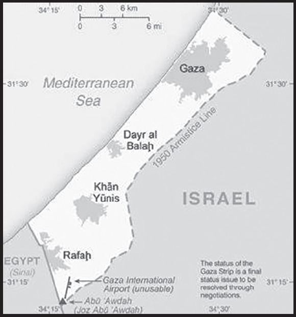
Location: Middle East, bordering the Mediterranean Sea, between Egypt and Israel
Geographic coordinates: 31 25 N, 34 20 E
Map references: Middle East
Area: total: 360 sq km
land: 360 sq km
water: 0 sq km
comparison ranking: total 206
Area - comparative: slightly more than twice the size of Washington, DC
Land boundaries: total: 72 km
border countries (2): Egypt 13 km; Israel 59 km
Coastline: 40 km
Maritime claims: see entry for Israel note: effective 3 January 2009, the Gaza maritime area is closed to all maritime traffic and is under blockade imposed by Israeli Navy until further notice
Climate: temperate, mild winters, dry and warm to hot summers
Terrain: flat to rolling, sand- and dune-covered coastal plain
Elevation: highest point: Abu ’Awdah (Joz Abu ’Awdah) 105 m
lowest point: Mediterranean Sea 0 m
Natural resources: arable land, natural gas
Irrigated land: (2013) 151 sq km; note - includes the West Bank
Population distribution: population concentrated in major cities, particularly Gaza City in the north
Natural hazards: droughts
Geography - note: once a strategic strip of land along Mideast-North African trade routes that has experienced an incredibly turbulent history; the town of Gaza itself has been besieged countless times in its history; Israel evacuated its civilian settlements and soldiers from the Gaza Strip in 2005
PEOPLE AND SOCIETY
Population: 2,098,389 (2023 est.)
comparison ranking: 150
Ethnic groups: Palestinian Arab
Languages: Arabic, Hebrew (spoken by many Palestinians), English (widely understood)
major-language sample(s):

(Arabic)
Religions: Muslim 98.0 - 99.0% (predominantly Sunni), Christian <1.0%, other, unaffiliated, unspecified <1.0% (2012 est.)
note: Israel dismantled its settlements in September 2005; Gaza has had no Jewish population since then
Age structure: 0-14 years: 39.75% (male 415,804/female 394,236)
15-64 years: 57.34% (male 580,693/female 587,807)
65 years and over: 2.91% (2023 est.) (male 31,671/female 27,533)
Dependency ratios: total dependency ratio: 74.3
youth dependency ratio: 68.2
elderly dependency ratio: 6.1
potential support ratio: 16.5 (2021 est.)
note: data represent Gaza Strip and the West Bank
Median age: total: 18 years (2020)
male: 17.7 years
female: 18.4 years
comparison ranking: total 215
Population growth rate: 1.99% (2023 est.)
comparison ranking: 39
Birth rate: 27.2 births/1,000 population (2023 est.)
comparison ranking: 39
Death rate: 2.88 deaths/1,000 population (2023 est.)
comparison ranking: 225
Net migration rate: -4.46 migrant(s)/1,000 population (2023 est.)
comparison ranking: 198
Population distribution: population concentrated in major cities, particularly Gaza City in the north
Urbanization: urban population: 77.6% of total population (2023)
rate of urbanization: 2.85% annual rate of change (2020-25 est.)
note: data represent Gaza Strip and the West Bank
Major urban areas - population: 778,000 Gaza (2023)
Sex ratio: at birth: 1.06 male(s)/female
0-14 years: 1.05 male(s)/female
15-64 years: 0.99 male(s)/female
65 years and over: 1.15 male(s)/female
total population: 1.02 male(s)/female (2023 est.)
Maternal mortality ratio: 20 deaths/100,000 live births (2020 est.)
note: data represent Gaza Strip and the West Bank
comparison ranking: 126
Infant mortality rate: total: 14.87 deaths/1,000 live births (2023 est.)
male: 16.01 deaths/1,000 live births
female: 13.67 deaths/1,000 live births
comparison ranking: total 98
Life expectancy at birth: total population: 75.66 years (2023 est.)
male: 73.92 years
female: 77.5 years
comparison ranking: total population 122
Total fertility rate: 3.34 children born/woman (2023 est.)
comparison ranking: 40
Gross reproduction rate: 1.62 (2023 est.)
Contraceptive prevalence rate: 57.3% (2019/20)
note: includes Gaza Strip and West Bank
Drinking water source: improved: urban: 98.9% of population
rural: 99% of population
total: 98.9% of population
unimproved: urban: 1.1% of population
rural: 1% of population
total: 1.1% of population (2020 est.)
note: includes Gaza Strip and the West Bank
Physicians density: 2.71 physicians/1,000 population (2020)
Hospital bed density: 1.3 beds/1,000 population (2019)
Sanitation facility access: improved: urban: 99.9% of population
rural: 98.6% of population
total: 99.6% of population
unimproved: urban: 0.1% of population
rural: 1.4% of population
total: 0.4% of population (2020 est.)
note: note includes Gaza Strip and the West Bank
Major infectious diseases: note: on 21 March 2022, the US Centers for Disease Control and Prevention (CDC) issued a Travel Alert for polio in Asia; the Gaza Strip is currently considered a high risk to travelers for polio; the CDC recommends that before any international travel, anyone unvaccinated, incompletely vaccinated, or with an unknown polio vaccination status should complete the routine polio vaccine series; before travel to any high-risk destination, the CDC recommends that adults who previously completed the full, routine polio vaccine series receive a single, lifetime booster dose of polio vaccine
Children under the age of 5 years underweight: 2.1% (2019/20)
note: estimate is for Gaza Strip and the West Bank
comparison ranking: 102
Currently married women (ages 15-49): 62.4% (2023 est.)
note: data includes Gaza and the West Bank
Child marriage: women married by age 15: 0.7%
women married by age 18: 13.4% (2020 est.)
note: includes both the Gaza Strip and the West Bank
Education expenditures: 5.3% of GDP (2018 est.)
note: includes Gaza Strip and the West Bank
comparison ranking: 66
Literacy: definition: age 15 and over can read and write
total population: 97.5%
male: 98.8%
female: 96.2% (2020)
note: estimates are for Gaza Strip and the West Bank
School life expectancy (primary to tertiary education): total: 13 years
male: 12 years
female: 14 years (2021)
note: data represent Gaza Strip and the West Bank
Youth unemployment rate (ages 15-24): total: 39.6% (2021 est.)
male: 33.7%
female: 69%
note: includes the West Bank
comparison ranking: total 15
ENVIRONMENT
Environment - current issues: soil degradation; desertification; water pollution from chemicals and pesticides; salination of fresh water; improper sewage treatment; water-borne disease; depletion and contamination of underground water resources
Climate: temperate, mild winters, dry and warm to hot summers
Urbanization: urban population: 77.6% of total population (2023)
rate of urbanization: 2.85% annual rate of change (2020-25 est.)
note: data represent Gaza Strip and the West Bank
Revenue from forest resources: 0% of GDP (2018 est.)
comparison ranking: 197
Air pollutants: particulate matter emissions: 30.82 micrograms per cubic meter (2019 est.)
carbon dioxide emissions: 3.23 megatons (2016 est.)
note: data represent combined total from the Gaza Strip and the West Bank.
Waste and recycling: municipal solid waste generated annually: 1.387 million tons (2016 est.)
municipal solid waste recycled annually: 6,935 tons (2013 est.)
percent of municipal solid waste recycled: 0.5% (2013 est.)
note: data represent combined total from the Gaza Strip and the West Bank.
Total water withdrawal: municipal: 181.2 million cubic meters (2017 est.)
industrial: 32 million cubic meters (2017 est.)
agricultural: 162 million cubic meters (2017 est.)
note: data represent combined total from the Gaza Strip and the West Bank.
Total renewable water resources: 840 million cubic meters (2020 est.)
note: data represent combined total from the Gaza Strip and the West Bank.
GOVERNMENT
Country name: conventional long form: none
conventional short form: Gaza Strip
local long form: none
local short form: Qita’ Ghazzah
etymology: named for the largest city in the enclave, Gaza, whose settlement can be traced back to at least the 15th century B.C. (as “Ghazzat”)
ECONOMY
Real GDP (purchasing power parity): $27.779 billion (2021 est.)
$25.95 billion (2020 est.)
$29.262 billion (2019 est.)
see entry for the West Bank
comparison ranking: 142
Real GDP growth rate: 7.05% (2021 est.)
-11.32% (2020 est.)
1.36% (2019 est.)
note: excludes the West Bank
comparison ranking: 56
Real GDP per capita: $5,600 (2021 est.)
$5,400 (2020 est.)
$6,200 (2019 est.)
see entry for the the West Bank
comparison ranking: 169
GDP (official exchange rate): $2.938 billion (2014 est.)
note: excludes the West Bank
Inflation rate (consumer prices): 1.24% (2021 est.)
-0.74% (2020 est.)
1.58% (2019 est.)
note: excludes the West Bank
comparison ranking: 190
GDP - composition, by sector of origin: agriculture: 3% (2017 est.)
industry: 21.1% (2017 est.)
services: 75% (2017 est.)
note: data exclude the West Bank
comparison rankings: services 47; industry 138; agriculture 150
GDP - composition, by end use: household consumption: 88.6% (2017 est.)
government consumption: 26.3% (2017 est.)
investment in fixed capital: 22.4% (2017 est.)
investment in inventories: 0% (2017 est.)
exports of goods and services: 18.6% (2017 est.)
imports of goods and services: -55.6% (2017 est.)
note: data exclude the West Bank
Agricultural products: tomatoes, cucumbers, olives, poultry, milk, potatoes, sheep milk, eggplants, gourds
Industries: textiles, food processing, furniture
Industrial production growth rate: 6.22% (2021 est.)
note: see entry for the West Bank
comparison ranking: 70
Labor force: 1.249 million (2021 est.)
note: excludes the West Bank
comparison ranking: 137
Labor force - by occupation: agriculture: 5.2%
industry: 10%
services: 84.8% (2015 est.)
note: data exclude the West Bank
Unemployment rate: 24.9% (2021 est.)
25.89% (2020 est.)
25.34% (2019 est.)
note: data exclude the West Bank
comparison ranking: 9
Youth unemployment rate (ages 15-24): total: 39.6% (2021 est.)
male: 33.7%
female: 69%
note: includes the West Bank
comparison ranking: total 15
Population below poverty line: 30% (2011 est.)
note: data exclude the West Bank
Gini Index coefficient - distribution of family income: 33.7 (2016 est.)
comparison ranking: 119
Budget: revenues: $3.803 billion (2020 est.)
expenditures: $5.002 billion (2020 est.)
see entry for the West Bank
Taxes and other revenues: 18.78% (of GDP) (2018 est.)
comparison ranking: 100
Fiscal year: calendar year
Current account balance: -$1.486 billion (2021 est.)
-$1.903 billion (2020 est.)
-$1.779 billion (2019 est.)
note: excludes the West Bank
comparison ranking: 145
Exports: $3.18 billion (2021 est.)
$2.385 billion (2020 est.)
$2.659 billion (2019 est.)
comparison ranking: 147
Exports - commodities: building stone, scrap iron, plastic lids, furniture, seating, dates, olive oil (2021)
note: data includes both Gaza Strip and West Bank export commodities
Imports: $10.245 billion (2021 est.)
$8.065 billion (2020 est.)
$9.161 billion (2019 est.)
see entry for the West Bank
comparison ranking: 112
Imports - commodities: food, consumer goods, fuel
Reserves of foreign exchange and gold: $872.541 million (31 December 2021 est.)
$697.075 million (31 December 2020 est.)
$658.352 million (31 December 2019 est.)
comparison ranking: 152
Debt - external: see entry for the West Bank
Exchange rates: see entry for the West Bank
ENERGY
Electricity access: electrification - total population: 100% (2021)
note: data for Gaza Strip and West Bank combined
Electricity: installed generating capacity: 215,000 kW (2020 est.)
consumption: 5,702,816,000 kWh (2019 est.)
imports: 5.9 billion kWh (2019 est.)
transmission/distribution losses: 847 million kWh (2019 est.)
comparison rankings: installed generating capacity 168; transmission/distribution losses 119; imports 37; exports 157; consumption 122
Electricity generation sources: fossil fuels: 100% of total installed capacity (2020 est.)
Petroleum: total petroleum production: 0 bbl/day (2021 est.)
refined petroleum consumption: 24,600 bbl/day (2019 est.)
Carbon dioxide emissions: 3.341 million metric tonnes of CO2 (2019 est.)
from petroleum and other liquids: 3.341 million metric tonnes of CO2 (2019 est.)
comparison ranking: total emissions 145
Energy consumption per capita: 13.604 million Btu/person (2019 est.)
comparison ranking: 143
COMMUNICATIONS
Telephones - fixed lines: total subscriptions: 485,829 (2021 est.)
subscriptions per 100 inhabitants: 9 (2021 est.)
includes the West Bank
comparison ranking: total subscriptions 94
Telephones - mobile cellular: total subscriptions: 4,052,966 (2021 est.)
subscriptions per 100 inhabitants: 78 (2021 est.)
includes the West Bank
comparison ranking: total subscriptions 132
Telecommunication systems: general assessment:
Israel, which controls Palestinian frequencies and telecom infrastructure, limits mobile internet speeds in the Palestinian territories to levels that are significantly lower than in Israel and Jewish West Bank settlements; the World Bank urged Israel to let Palestinian cellular companies set up more advanced networks, and to ease restrictions on the import of equipment needed to build and operate them; Israel is rolling out fifth generation technology for its citizens, while the West Bank operates on 3G and Gaza, 2G; Israeli mobile operators don’t officially service Palestinian areas, but many Palestinians use the faster Israeli networks with SIM cards; the Times of Israel reported in November that Israel tentatively agreed to let Palestinian operators launch 4G services
(2022)
domestic: fixed-line 9 per 100 and mobile-cellular 28 per 100 (includes West Bank) (2021)
international: country code 970 or 972 (2018)
Broadcast media: 1 TV station and about 10 radio stations; satellite TV accessible
Internet country code: .ps; note - IANA has designated .ps for the Gaza Strip, same as the West Bank
Internet users: total: 3,602,452 (2020 est.)
percent of population: 75% (2020 est.)
note: includes the West Bank
comparison ranking: total 113
Broadband - fixed subscriptions: total: 376,911 (2020 est.)
subscriptions per 100 inhabitants: 7 (2020 est.)
note: includes the West Bank
comparison ranking: total 100
TRANSPORTATION
Airports: 1 (2021)
comparison ranking: total 231
Airports - with paved runways: 1
note: non-operational
Heliports: 1 (2021)
Roadways: note: see entry for the West Bank
Ports and terminals: major seaport(s): Gaza
MILITARY AND SECURITY
Military and security forces: HAMAS does not have a conventional military in the Gaza Strip but maintains security forces in addition to its military wing, the ’Izz al-Din al-Qassam Brigades; the military wing reports to the HAMAS Political Bureau; there are several other militant groups operating in the Gaza Strip, most notably the Al-Quds Brigades of Palestine Islamic Jihad, which are usually but not always beholden to HAMAS’s authority (2023)
Military expenditures: not available
Military and security service personnel strengths: the military wing of HAMAS has an estimated 20-25,000 fighters (2023)
Military equipment inventories and acquisitions: the military wing of HAMAS is armed with light weapons, including an inventory of improvised rocket, anti-tank missile, and mortar capabilities; HAMAS acquires its weapons through smuggling or local construction and receives some military support from Iran (2023)
Military - note: since seizing control of the Gaza Strip in 2007, HAMAS has had repeated clashes with Israel, including armed conflicts in 2008-2009, 2012, 2014, 2021, and 2023; Palestine Islamic Jihad (PIJ) also operates in the Gaza Strip and has cooperated with HAMAS; see Appendix T for more details on HAMAS and PIJ (2023)
TERRORISM
Terrorist group(s): Terrorist group(s): Army of Islam; Abdallah Azzam Brigades; al-Aqsa Martyrs Brigade; HAMAS; Islamic Revolutionary Guard Corps/Qods Force; Islamic State of Iraq and ash-Sham - Sinai Province (ISIS-SP); Mujahidin Shura Council in the Environs of Jerusalem; Palestine Islamic Jihad (PIJ); Palestine Liberation Front; Popular Front for the Liberation of Palestine (PFLP); PFLP-General Command
note: details about the history, aims, leadership, organization, areas of operation, tactics, targets, weapons, size, and sources of support of the group(s) appear(s) in Appendix-T
TRANSNATIONAL ISSUES
Disputes - international: borders with both Egypt and Israel are sealed with barriers, fences, and walls; Israel completed an underground anti-tunnel barrier in 2021
Refugees and internally displaced persons: refugees (country of origin): 1.6 million (Palestinian refugees) (2022)
IDPs: 1.6 million (includes persons displaced within the Gaza Strip due to the intensification of the Israeli-Palestinian conflict since June 2014 and other Palestinian IDPs in the Gaza Strip and West Bank who fled as long ago as 1967, although confirmed cumulative data do not go back beyond 2006) (2023); note - data represent Gaza Strip
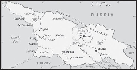
INTRODUCTION
Background: The region of present day Georgia contained the ancient kingdoms of Colchis and Kartli-Iberia. The area came under Roman influence in the first centuries A.D., and Christianity became the state religion in the 330s. Domination by Persians, Arabs, and Turks was followed by a Georgian golden age (11th-13th centuries) that was cut short by the Mongol invasion of 1236. Subsequently, the Ottoman and Persian empires competed for influence in the region. Georgia was absorbed into the Russian Empire in the 19th century. Independent for three years (1918-1921) following the Russian revolution, it was forcibly incorporated into the USSR in 1921 and regained its independence when the Soviet Union dissolved in 1991.
Mounting public discontent over rampant corruption and ineffective government services, followed by an attempt by the incumbent Georgian Government to manipulate parliamentary elections in November 2003, touched off widespread protests that led to the resignation of Eduard SHEVARDNADZE, president since 1995. In the aftermath of that popular movement, which became known as the “Rose Revolution,” new elections in early 2004 swept Mikheil SAAKASHVILI into power along with his United National Movement (UNM) party. SAAKASHVILI made progress on market reforms and good governance during his time in power but also faced accusations of abuse of office. Progress was also complicated by Russian assistance and support to the separatist regions of Abkhazia and South Ossetia that led to periodic flare-ups in tension and violence and that culminated in a five-day conflict in August 2008 between Russia and Georgia, including the invasion of large portions of Georgian territory. Russian troops pledged to pull back from most occupied Georgian territory, but in late August 2008 Russia unilaterally recognized the independence of Abkhazia and South Ossetia, and Russian military forces remain in those regions.
Billionaire Bidzina IVANISHVILI’s unexpected entry into politics in October 2011 brought the divided opposition together under his Georgian Dream coalition, which won a majority of seats in the October 2012 parliamentary elections and removed UNM from power. Conceding defeat, SAAKASHVILI named IVANISHVILI as prime minister and allowed Georgian Dream to create a new government before leaving the country after his presidential term ended in 2013. At the time, these changes in leadership represented unique examples of a former Soviet state that emerged to conduct democratic and peaceful government transitions of power. IVANISHVILI voluntarily resigned from office after the presidential succession, and in the following years, the prime minister position has seen frequent turnover. Most recently, Irakli GARIBASHVILI became prime minister in February 2021. In October 2021, SAAKASHVILI returned to Georgia, where he was immediately arrested to serve six years in prison on outstanding abuse of office convictions. Popular support for integration with the West is high in Georgia. Joining the EU and NATO are among the country’s top foreign policy goals and Georgia applied for EU membership in March 2022. The EU and Georgia signed an Association Agreement in June 2014 and it fully entered into force in July 2016. Georgia and the EU have a Deep and Comprehensive Free Trade Agreement and Georgian citizens since 2017 can travel to the Schengen area without a visa.
GEOGRAPHY
Location: Southwestern Asia, bordering the Black Sea, between Turkey and Russia, with a sliver of land north of the Caucasus extending into Europe; note - Georgia views itself as part of Europe; geopolitically, it can be classified as falling within Europe, the Middle East, or both
Geographic coordinates: 42 00 N, 43 30 E
Map references: Asia
Area: total: 69,700 sq km
land: 69,700 sq km
water: 0 sq km
note: approximately 12,560 sq km, or about 18% of Georgia’s area, is Russian occupied; the seized area includes all of Abkhazia and the breakaway region of South Ossetia, which consists of the northern part of Shida Kartli, eastern slivers of the Imereti region and Racha-Lechkhumi and Kvemo Svaneti, and part of western Mtskheta-Mtianeti
comparison ranking: total 121
Area - comparative: slightly smaller than South Carolina; slightly larger than West Virginia
Land boundaries: total: 1,814 km
border countries (4): Armenia 219 km; Azerbaijan 428 km; Russia 894 km; Turkey 273 km
Coastline: 310 km
Maritime claims: territorial sea: 12 nm
exclusive economic zone: 200 nm
Climate: warm and pleasant; Mediterranean-like on Black Sea coast
Terrain: largely mountainous with Great Caucasus Mountains in the north and Lesser Caucasus Mountains in the south; Kolkhet’is Dablobi (Kolkhida Lowland) opens to the Black Sea in the west; Mtkvari River Basin in the east; fertile soils in river valley flood plains and foothills of Kolkhida Lowland
Elevation: highest point: Mt’a Shkhara 5,193 m
lowest point: Black Sea 0 m
mean elevation: 1,432 m
Natural resources: timber, hydropower, manganese deposits, iron ore, copper, minor coal and oil deposits; coastal climate and soils allow for important tea and citrus growth
Land use: agricultural land: 35.5% (2018 est.)
arable land: 5.8% (2018 est.)
permanent crops: 1.8% (2018 est.)
permanent pasture: 27.9% (2018 est.)
forest: 39.4% (2018 est.)
other: 25.1% (2018 est.)
Irrigated land: 4,330 sq km (2012)
Population distribution: settlement concentrated in the central valley, particularly in the capital city of Tbilisi in the east; smaller urban agglomerations dot the Black Sea coast, with Bat’umi being the largest
Natural hazards: earthquakes
Geography - note: note 1: strategically located east of the Black Sea; Georgia controls much of the Caucasus Mountains and the routes through them
note 2: the world’s four deepest caves are all in Georgia, including two that are the only known caves on earth deeper than 2,000 m: Krubera Cave at -2,197 m (-7,208 ft; reached in 2012) and Veryovkina Cave at -2,212 (-7,257 ft; reached in 2018)
PEOPLE AND SOCIETY
Population: 4,936,390 (2023 est.)
comparison ranking: 126
Nationality: noun: Georgian(s)
adjective: Georgian
Ethnic groups: Georgian 86.8%, Azeri 6.3%, Armenian 4.5%, other 2.3% (includes Russian, Ossetian, Yazidi, Ukrainian, Kist, Greek) (2014 est.)
Languages: Georgian (official) 87.6%, Azeri 6.2%, Armenian 3.9%, Russian 1.2%, other 1%; note - Abkhaz is the official language in Abkhazia (2014 est.)
major-language sample(s):
(Georgian)
Religions: Eastern Orthodox Christian (official) 83.4%, Muslim 10.7%, Armenian Apostolic Christian 2.9%, other 1.2% (includes Roman Catholic Christian, Jehovah’s Witness, Yazidi, Protestant Christian, Jewish), none 0.5%, unspecified/no answer 1.2% (2014 est.)
Demographic profile: Analyzing population trends in Georgia since independence in 1991 has proven difficult due to a lack of reliable demographic statistics. Censuses were fairly accurately and regularly updated through a vital statistics system during Georgia’s period of Soviet rule, but from independence until about 2010, the system broke down as a result of institutional and economic change, social unrest, and large-scale outmigration. The 2002 census is believed to have significantly overestimated the size of Georgia’s population, in part because respondents continued to include relatives living abroad as part of their household count. The 2014 census indicates that Georgia’s population is decreasing and aging. Census data shows that the median age increased from 34.5 years in 2002 to 37.7 years in 2014. The working-age population (ages 15-65 years) was fairly high in 2002 and rose between 2005 and 2011. Nonetheless, Georgia did not reap economic benefits from this age structure, since the working-age population increase seems to have stimulated labor outmigration to Russia, Ukraine, and other neighboring countries.
Since the Russian invasion of Ukraine in 2022, Georgia has seen its economy grow to its highest level in years due to the influx of Russian businesses, information and communications technology specialists, and money transfers. This growth may only be temporary and conditions could still easily change depending on future events. Meanwhile, the Russian inflow is also a source of concern, as some Georgians fear it could prompt Putin to target their country next. In addition, Ukrainian refugees use Georgia not just as a transit country but also as a destination. Some 25,000 Ukrainians remain in the country as of November 2022; they pose an additional strain on resources in Georgia, which has a significant population of its own displaced citizens – from the 2008 Russian occupation of Abkhazia and South Ossetia – who continue to need government support.
Age structure: 0-14 years: 18.41% (male 468,459/female 440,195)
15-64 years: 63.65% (male 1,543,748/female 1,598,047)
65 years and over: 17.95% (2023 est.) (male 348,822/female 537,119)
Dependency ratios: total dependency ratio: 55.4
youth dependency ratio: 32.8
elderly dependency ratio: 22.6
potential support ratio: 4.4 (2021 est.)
Median age: total: 38.6 years (2020)
male: 35.9 years
female: 41.4 years
comparison ranking: total 60
Population growth rate: 0.01% (2023 est.)
comparison ranking: 191
Birth rate: 10.79 births/1,000 population (2023 est.)
comparison ranking: 173
Death rate: 10.76 deaths/1,000 population (2023 est.)
comparison ranking: 26
Net migration rate: 0.06 migrant(s)/1,000 population (2023 est.)
comparison ranking: 81
Population distribution: settlement concentrated in the central valley, particularly in the capital city of Tbilisi in the east; smaller urban agglomerations dot the Black Sea coast, with Bat’umi being the largest
Urbanization: urban population: 60.7% of total population (2023)
rate of urbanization: 0.35% annual rate of change (2020-25 est.)
note: data include Abkhazia and South Ossetia
Major urban areas - population: 1.082 million TBILISI (capital) (2023)
Sex ratio: at birth: 1.05 male(s)/female
0-14 years: 1.06 male(s)/female
15-64 years: 0.97 male(s)/female
65 years and over: 0.65 male(s)/female
total population: 0.92 male(s)/female (2023 est.)
Mother’s mean age at first birth: 25.9 years (2019 est.)
note: data does not cover Abkhazia and South Ossetia
Maternal mortality ratio: 28 deaths/100,000 live births (2020 est.)
comparison ranking: 114
Infant mortality rate: total: 14.45 deaths/1,000 live births (2023 est.)
male: 16.55 deaths/1,000 live births
female: 12.23 deaths/1,000 live births
comparison ranking: total 101
Life expectancy at birth: total population: 77.74 years (2023 est.)
male: 73.72 years
female: 81.96 years
comparison ranking: total population 90
Total fertility rate: 1.75 children born/woman (2023 est.)
comparison ranking: 152
Gross reproduction rate: 0.85 (2023 est.)
Contraceptive prevalence rate: 40.6% (2018)
Drinking water source: improved: urban: 99.4% of population
rural: 94.3% of population
total: 97.3% of population
unimproved: urban: 0.6% of population
rural: 5.7% of population
total: 2.7% of population (2020 est.)
Current health expenditure: 7.6% of GDP (2020)
Physicians density: 5.11 physicians/1,000 population (2020)
Hospital bed density: 2.9 beds/1,000 population (2014)
Sanitation facility access: improved: urban: 96.3% of population
rural: 72.7% of population
total: 86.7% of population
unimproved: urban: 3.7% of population
rural: 27.3% of population
total: 13.3% of population (2020 est.)
Obesity - adult prevalence rate: 21.7% (2016)
comparison ranking: 85
Alcohol consumption per capita: total: 7.45 liters of pure alcohol (2019 est.)
beer: 1.71 liters of pure alcohol (2019 est.)
wine: 3.19 liters of pure alcohol (2019 est.)
spirits: 2.52 liters of pure alcohol (2019 est.)
other alcohols: 0.02 liters of pure alcohol (2019 est.)
comparison ranking: total 53
Tobacco use: total: 31.7% (2020 est.)
male: 56.3% (2020 est.)
female: 7.1% (2020 est.)
comparison ranking: total 24
Children under the age of 5 years underweight: 2.1% (2018)
comparison ranking: 104
Currently married women (ages 15-49): 67.1% (2023 est.)
Child marriage: women married by age 15: 0.3%
women married by age 18: 13.9%
men married by age 18: 0.5% (2018 est.)
Education expenditures: 3.6% of GDP (2021 est.)
comparison ranking: 135
Literacy: definition: age 15 and over can read and write
total population: 99.6%
male: 99.7%
female: 99.5% (2019)
School life expectancy (primary to tertiary education): total: 16 years
male: 16 years
female: 16 years (2021)
Youth unemployment rate (ages 15-24): total: 28.3% (2021 est.)
male: 27.4%
female: 29.9%
comparison ranking: total 45
ENVIRONMENT
Environment - current issues: air pollution, particularly in Rust’avi; heavy water pollution of Mtkvari River and the Black Sea; inadequate supplies of potable water; soil pollution from toxic chemicals; land and forest degradation; biodiversity loss; waste management
Environment - international agreements: party to: Air Pollution, Biodiversity, Climate Change, Climate Change-Kyoto Protocol, Climate Change-Paris Agreement, Comprehensive Nuclear Test Ban, Desertification, Endangered Species, Hazardous Wastes, Law of the Sea, Marine Dumping-London Protocol, Ozone Layer Protection, Ship Pollution, Wetlands
signed, but not ratified: none of the selected agreements
Climate: warm and pleasant; Mediterranean-like on Black Sea coast
Land use: agricultural land: 35.5% (2018 est.)
arable land: 5.8% (2018 est.)
permanent crops: 1.8% (2018 est.)
permanent pasture: 27.9% (2018 est.)
forest: 39.4% (2018 est.)
other: 25.1% (2018 est.)
Urbanization: urban population: 60.7% of total population (2023)
rate of urbanization: 0.35% annual rate of change (2020-25 est.)
note: data include Abkhazia and South Ossetia
Revenue from forest resources: 0.07% of GDP (2018 est.)
comparison ranking: 122
Revenue from coal: 0.01% of GDP (2018 est.)
comparison ranking: 52
Air pollutants: particulate matter emissions: 19.06 micrograms per cubic meter (2019 est.)
carbon dioxide emissions: 10.13 megatons (2016 est.)
methane emissions: 6.05 megatons (2020 est.)
Waste and recycling: municipal solid waste generated annually: 800,000 tons (2015 est.)
Total water withdrawal: municipal: 610 million cubic meters (2020 est.)
industrial: 340 million cubic meters (2020 est.)
agricultural: 710 million cubic meters (2020 est.)
Total renewable water resources: 63.33 billion cubic meters (2020 est.)
GOVERNMENT
Country name: conventional long form: none
conventional short form: Georgia
local long form: none
local short form: Sak’art’velo
former: Georgian Soviet Socialist Republic
etymology: the Western name may derive from the Persian designation “gurgan” meaning “Land of the Wolves”; the native name “Sak’art’velo” means “Land of the Kartvelians” and refers to the core central Georgian region of Kartli
Government type: semi-presidential republic
Capital: name: Tbilisi
geographic coordinates: 41 41 N, 44 50 E
time difference: UTC+4 (9 hours ahead of Washington, DC, during Standard Time)
etymology: the name in Georgian means “warm place,” referring to the numerous sulfuric hot springs in the area
Administrative divisions: 9 regions (mkharebi, singular - mkhare), 1 city (kalaki), and 2 autonomous republics (avtomnoy respubliki, singular - avtom respublika)
regions: Guria, Imereti, Kakheti, Kvemo Kartli, Mtskheta Mtianeti, Racha-Lechkhumi and Kvemo Svaneti, Samegrelo and Zemo Svaneti, Samtskhe-Javakheti, Shida Kartli; note - the breakaway region of South Ossetia consists of the northern part of Shida Kartli, eastern slivers of the Imereti region and Racha-Lechkhumi and Kvemo Svaneti, and part of western Mtskheta-Mtianeti
city: Tbilisi
autonomous republics: Abkhazia or Ap’khazet’is Avtonomiuri Respublika (Sokhumi), Ajaria or Acharis Avtonomiuri Respublika (Bat’umi)
note 1: the administrative centers of the two autonomous republics are shown in parentheses
note 2: the United States recognizes the breakaway regions of Abkhazia and South Ossetia to be part of Georgia
Independence: 9 April 1991 (from the Soviet Union); notable earlier date: A.D. 1008 (Georgia unified under King BAGRAT III)
National holiday: Independence Day, 26 May (1918); note - 26 May 1918 was the date of independence from Soviet Russia, 9 April 1991 was the date of independence from the Soviet Union
Constitution: history: previous 1921, 1978 (based on 1977 Soviet Union constitution); latest approved 24 August 1995, effective 17 October 1995
amendments: proposed as a draft law supported by more than one half of the Parliament membership or by petition of at least 200,000 voters; passage requires support by at least three fourths of the Parliament membership in two successive sessions three months apart and the signature and promulgation by the president of Georgia; amended several times, last in 2020 (legislative electoral system revised)
Legal system: civil law system
International law organization participation: accepts compulsory ICJ jurisdiction; accepts ICCt jurisdiction
Citizenship: citizenship by birth: no
citizenship by descent only: at least one parent must be a citizen of Georgia
dual citizenship recognized: no
residency requirement for naturalization: 10 years
Suffrage: 18 years of age; universal
Executive branch: chief of state: President Salome ZOURABICHVILI (since 16 December 2018)
head of government: Prime Minister Irakli GARIBASHVILI (since 22 February 2021)
cabinet: Cabinet of Ministers
elections/appointments: president directly elected by absolute majority popular vote in 2 rounds if needed for a 5-year term (eligible for a second term); election last held on 28 November 2018 (next to be held in 2024); prime minister nominated by Parliament, appointed by the president
note - 2017 constitutional amendments made the 2018 election the last where the president was directly elected; future presidents will be elected by a 300-member College of Electors; in light of these changes, ZOURABICHVILI was allowed a six-year term
election results:
2018: Salome ZOURABICHVILI elected president in runoff; percent of vote - Salome ZOURABICHVILI (independent, backed by Georgian Dream) 59.5%, Grigol VASHADZE (UNM) 40.5%; Irakli GARIBASHVILI approved as prime minister by Parliamentary vote 89-2
2013: Giorgi MARGVELASHVILI elected president (Georgian Dream) 62.1%, David BAKRADZE (ENM) 21.7%, Nino BURJANADZE (DM-UG) 10.2%, other 6%
Legislative branch: description: unicameral Parliament or Sakartvelos Parlamenti (150 seats statutory, 140 (as of May 2023); 120 members directly elected in a single nationwide constituency by closed, party-list proportional representation vote and 30 directly elected in single-seat constituencies by at least 50% majority vote, with a runoff if needed; no party earning less than 40% of total votes may claim a majority; members serve 4-year terms)
elections: last held on 31 October and 21 November 2020 (next to be held in October 2024)
election results: percent of vote by party - Georgian Dream 48.2%, UNM 27.2%, European Georgia 3.8%, Lelo 3.2%, Strategy 3.2%, Alliance of Patriots 3.1%, Girchi 2.9%, Citizens 1.3%, Labor 1%; seats by party - Georgian Dream 90, UNM 36, European Georgia 5, Lelo 4, Strategy 4, Alliance of Patriots 4, Girchi 4, Citizens 2, Labor 1; composition (as of October 2021) - men 117, women 27, percent of women 19.3%
Judicial branch: highest court(s): Supreme Court (consists of 28 judges organized into several specialized judicial chambers; number of judges determined by the president of Georgia); Constitutional Court (consists of 9 judges); note - the Abkhazian and Ajarian Autonomous republics each have a supreme court and a hierarchy of lower courts
judge selection and term of office: Supreme Court judges nominated by the High Council of Justice (a 14-member body consisting of the Supreme Court chairperson, common court judges, and appointees of the president of Georgia) and appointed by Parliament; judges appointed for life; Constitutional Court judges appointed 3 each by the president, by Parliament, and by the Supreme Court judges; judges appointed for 10-year terms
subordinate courts: Courts of Appeal; regional (town) and district courts
Political parties and leaders: Alliance of Patriots [Davit TARKHAN-MOURAVI]
Citizens Party [Aleko ELISASHVILI]
Democratic Movement-United Georgia or DM-UC [Nino BURJANADZE]
European Georgia-Movement for Liberty [Giga BOKERIA]
European Socialists [Fridon INJIA]
For Georgia [Giorgi GAKHARIA]
Georgian Dream-Democratic Georgia [Irakli KOBAKHIDZE]
Girchi-More Freedom [Zurab JAPARIDZE]
Labor Party [Shalva NATELASHVILI]
Lelo for Georgia [Mamuka KHAZARADZE]
New Political Centre-Girchi [Iago KHVICHIA]
Republican Party [Khatuna SAMNIDZE]
Strategy Aghmashenebeli [Giorgi VASHADZE]
United National Movement or UNM [Levan KHABEISHVILI]
International organization participation: ADB, BSEC, CD, CE, CPLP (associate), EAPC, EBRD, FAO, G-11, GCTU, GUAM, IAEA, IBRD, ICAO, ICC (national committees), ICCt, ICRM, IDA, IFAD, IFC, IFRCS, ILO, IMF, IMO, Interpol, IOC, IOM, IPU, ISO (correspondent), ITSO, ITU, ITUC (NGOs), MIGA, OAS (observer), OIF (observer), OPCW, OSCE, PFP, SELEC (observer), UN, UNCTAD, UNESCO, UNIDO, UNWTO, UPU, WCO, WHO, WIPO, WMO, WTO
Diplomatic representation in the US: chief of mission: Ambassador David ZALKALIANI (since 7 June 2022)
chancery: 1824 R Street NW, Washington, DC 20009
telephone: [1] (202) 387-2390
FAX: [1] (202) 387-0864
email address and website:
https://georgiaembassyusa.org/contact/
consulate(s) general: New York
Diplomatic representation from the US: chief of mission: Ambassador Robin DUNNIGAN (since 12 October 2023)
embassy: 29 Georgian-American Friendship Avenue, Didi Dighomi, Tbilisi, 0131
mailing address: 7060 Tbilisi Place, Washington, DC 20521-7060
telephone: [995] (32) 227-70-00
FAX: [995] (32) 253-23-10
email address and website:
Flag description: white rectangle with a central red cross extending to all four sides of the flag; each of the four quadrants displays a small red bolnur-katskhuri cross; sometimes referred to as the Five-Cross Flag; although adopted as the official Georgian flag in 2004, the five-cross design is based on a 14th century banner of the Kingdom of Georgia
National symbol(s): Saint George, lion; national colors: red, white
National anthem: name: “Tavisupleba” (Liberty)
lyrics/music: Davit MAGRADSE/Zakaria PALIASHVILI (adapted by Joseb KETSCHAKMADSE)
note: adopted 2004; after the Rose Revolution, a new anthem with music based on the operas “Abesalom da Eteri” and “Daisi” was adopted
National heritage: total World Heritage Sites: 4 (3 cultural, 1 natural)
selected World Heritage Site locales: Gelati Monastery (c); Historical Monuments of Mtskheta (c); Upper Svaneti (c); Colchic Rainforests and Wetlands (n)
ECONOMY
Economic overview: COVID-19 crippled tourism, transportation, and construction sectors; rising unemployment, public debts and poverty; foreign investment and domestic bond issuance
Real GDP (purchasing power parity): $57.434 billion (2021 est.)
$51.993 billion (2020 est.)
$55.762 billion (2019 est.)
note: data are in 2017 dollars
comparison ranking: 109
Real GDP growth rate: 10.47% (2021 est.)
-6.76% (2020 est.)
4.98% (2019 est.)
comparison ranking: 26
Real GDP per capita: $15,500 (2021 est.)
$14,000 (2020 est.)
$15,000 (2019 est.)
note: data are in 2017 dollars
comparison ranking: 105
GDP (official exchange rate): $17.694 billion (2019 est.)
Inflation rate (consumer prices): 9.57% (2021 est.)
5.2% (2020 est.)
4.85% (2019 est.)
comparison ranking: 25
Credit ratings: Fitch rating: BB (2019)
Moody’s rating: Ba2 (2017)
Standard & Poors rating: BB (2019)
note: The year refers to the year in which the current credit rating was first obtained.
GDP - composition, by sector of origin: agriculture: 8.2% (2017 est.)
industry: 23.7% (2017 est.)
services: 67.9% (2017 est.)
comparison rankings: services 83; industry 119; agriculture 98
GDP - composition, by end use: household consumption: 62.8% (2017 est.)
government consumption: 17.1% (2017 est.)
investment in fixed capital: 29.5% (2017 est.)
investment in inventories: 2.4% (2017 est.)
exports of goods and services: 50.4% (2017 est.)
imports of goods and services: -62.2% (2017 est.)
Agricultural products: milk, grapes, maize, potatoes, wheat, watermelons, tomatoes, tangerines/mandarins, barley, apples
Industries: steel, machine tools, electrical appliances, mining (manganese, copper, gold), chemicals, wood products, wine
Industrial production growth rate: 2.4% (2021 est.)
comparison ranking: 130
Labor force: 1.724 million (2021 est.)
comparison ranking: 129
Labor force - by occupation: agriculture: 55.6%
industry: 8.9%
services: 35.5% (2006 est.)
Unemployment rate: 10.66% (2021 est.)
18.5% (2020 est.)
11.57% (2019 est.)
comparison ranking: 66
Youth unemployment rate (ages 15-24): total: 28.3% (2021 est.)
male: 27.4%
female: 29.9%
comparison ranking: total 45
Population below poverty line: 19.5% (2019 est.)
Gini Index coefficient - distribution of family income: 34.5 (2020 est.)
comparison ranking: 108
Average household expenditures: on food: 32.3% of household expenditures (2018 est.)
on alcohol and tobacco: 3.4% of household expenditures (2018 est.)
Household income or consumption by percentage share: lowest 10%: 2%
highest 10%: 31.3% (2008)
Budget: revenues: $4.737 billion (2019 est.)
expenditures: $5.059 billion (2019 est.)
Budget surplus (+) or deficit (-): -3.8% (of GDP) (2017 est.)
comparison ranking: 151
Public debt: 65.88% of GDP (2020 est.)
45.15% of GDP (2019 est.)
38.89% of GDP (2018 est.)
note: data cover general government debt and include debt instruments issued (or owned) by government entities other than the treasury; the data include treasury debt held by foreign entities; the data include debt issued by subnational entities; Georgia does not maintain intragovernmental debt or social funds
comparison ranking: 66
Taxes and other revenues: 21.41% (of GDP) (2020 est.)
comparison ranking: 77
Fiscal year: calendar year
Current account balance: -$1.937 billion (2021 est.)
-$1.981 billion (2020 est.)
-$1.025 billion (2019 est.)
comparison ranking: 155
Exports: $8.086 billion (2021 est.) note: data are in current year dollars
$5.927 billion (2020 est.) note: data are in current year dollars
$9.546 billion (2019 est.) note: data are in current year dollars
comparison ranking: 114
Exports - partners: Russia 12%, Azerbaijan 12%, Armenia 9%, Bulgaria 8%, China 6%, Turkey 6%, Ukraine 6% (2019)
Exports - commodities: copper, iron alloys, cars, wine, refined petroleum, nitrogen fertilizers, liquors (2021)
Imports: $11.151 billion (2021 est.) note: data are in current year dollars
$8.967 billion (2020 est.) note: data are in current year dollars
$11.162 billion (2019 est.) note: data are in current year dollars
comparison ranking: 106
Imports - partners: Turkey 17%, China 11%, Russia 9%, Azerbaijan 6%, United States 6%, Germany 5% (2019)
Imports - commodities: cars, refined petroleum, copper, packaged medicines, natural gas (2019)
Reserves of foreign exchange and gold: $4.271 billion (31 December 2021 est.)
$3.913 billion (31 December 2020 est.)
$3.506 billion (31 December 2019 est.)
comparison ranking: 107
Debt - external: $18.149 billion (2019 est.)
$17.608 billion (2018 est.)
comparison ranking: 96
Exchange rates: laris (GEL) per US dollar -
Exchange rates: 3.222 (2021 est.)
3.109 (2020 est.)
2.818 (2019 est.)
2.534 (2018 est.)
2.51 (2017 est.)
ENERGY
Electricity access: electrification - total population: 100% (2021)
Electricity: installed generating capacity: 4.579 million kW (2020 est.)
consumption: 12,062,080,000 kWh (2019 est.)
exports: 256 million kWh (2020 est.)
imports: 1.712 billion kWh (2020 est.)
transmission/distribution losses: 918.2 million kWh (2019 est.)
comparison rankings: imports 62; exports 85; installed generating capacity 92; transmission/distribution losses 115; consumption 92
Electricity generation sources: fossil fuels: 25.3% of total installed capacity (2020 est.)
wind: 0.8% of total installed capacity (2020 est.)
hydroelectricity: 73.9% of total installed capacity (2020 est.)
Coal: production: 99,000 metric tons (2020 est.)
consumption: 362,000 metric tons (2020 est.)
exports: 1,000 metric tons (2020 est.)
imports: 277,000 metric tons (2020 est.)
proven reserves: 201 million metric tons (2019 est.)
Petroleum: total petroleum production: 300 bbl/day (2021 est.)
refined petroleum consumption: 32,400 bbl/day (2019 est.)
crude oil and lease condensate exports: 100 bbl/day (2018 est.)
crude oil and lease condensate imports: 0 bbl/day (2018 est.)
crude oil estimated reserves: 35 million barrels (2021 est.)
Refined petroleum products - production: 247 bbl/day (2017 est.)
comparison ranking: 106
Refined petroleum products - exports: 2,052 bbl/day (2015 est.)
comparison ranking: 104
Refined petroleum products - imports: 28,490 bbl/day (2015 est.)
comparison ranking: 101
Natural gas: production: 6.088 million cubic meters (2020 est.)
consumption: 2.54 billion cubic meters (2020 est.)
exports: 0 cubic meters (2021 est.)
imports: 2.535 billion cubic meters (2020 est.)
proven reserves: 8.495 billion cubic meters (2021 est.)
Carbon dioxide emissions: 10.299 million metric tonnes of CO2 (2019 est.)
from coal and metallurgical coke: 1.063 million metric tonnes of CO2 (2019 est.)
from petroleum and other liquids: 4.245 million metric tonnes of CO2 (2019 est.)
from consumed natural gas: 4.992 million metric tonnes of CO2 (2019 est.)
comparison ranking: total emissions 104
Energy consumption per capita: 63.286 million Btu/person (2019 est.)
comparison ranking: 87
COMMUNICATIONS
Telephones - fixed lines: total subscriptions: 337,923 (2021 est.)
subscriptions per 100 inhabitants: 9 (2021 est.)
comparison ranking: total subscriptions 106
Telephones - mobile cellular: total subscriptions: 5,163,558 (2021 est.)
subscriptions per 100 inhabitants: 137 (2021 est.)
comparison ranking: total subscriptions 123
Telecommunication systems: general assessment: the telecom sector has been attempting for many years to overcome the decades of under-investment in its fixed-line infrastructure during the Soviet era; concerted efforts to privatize state-owned enterprises and open up the telecom market have been mostly successful, with a large number of networks now competing in both the fixed-line and the mobile segments; more needs to be done, however, to give investors the confidence to enter a market that has barely moved in terms of revenue growth over the last decade, and where regulatory overreach has sometimes come perilously close to arresting further development; Georgia’s government moved fast following the collapse of the Soviet Union to liberalize the country’s telecom market; this resulted in a relatively high number of networks competing in the under-developed fixed-line segment as well as in the emerging mobile market; both segments remain dominated by just a few companies (2022)
domestic: fixed-line subscriptions 9 per 100, mobile-cellular teledensity roughly 137 per 100 persons (2021)
international: country code - 995; landing points for the Georgia-Russia, Diamond Link Global, and Caucasus Cable System fiber-optic submarine cable that provides connectivity to Russia, Romania and Bulgaria; international service is available by microwave, landline, and satellite through the Moscow switch; international electronic mail and telex service are available (2019)
Broadcast media: The Tbilisi-based Georgian Public Broadcaster (GPB) includes Channel 1, Channel 2, and the Batumi-based Adjara TV, and the State Budget funds all three; there are also a number of independent commercial television broadcasters, such as Imedi, Rustavi 2, Pirveli TV, Maestro, Kavkasia, Georgian Dream Studios (GDS), Obiektivi, Mtavari Arkhi, and a small Russian language operator TOK TV; Tabula and Post TV are web-based television outlets; all of these broadcasters and web-based television outlets, except GDS, carry the news; the Georgian Orthodox Church also operates a satellite-based television station called Unanimity; there are 26 regional television broadcasters across Georgia that are members of the Georgian Association of Regional Broadcasters and/or the Alliance of Georgian Broadcasters; the broadcaster organizations seek to strengthen the regional media’s capacities and distribution of regional products: a nationwide digital switchover occurred in 2015; there are several dozen private radio stations; GPB operates 2 radio stations (2019)
Internet country code: .ge
Internet users: total: 2.888 million (2021 est.)
percent of population: 76% (2021 est.)
comparison ranking: total 123
Broadband - fixed subscriptions: total: 986,809 (2021 est.)
subscriptions per 100 inhabitants: 25 (2021 est.)
comparison ranking: total 75
TRANSPORTATION
National air transport system: number of registered air carriers: 4 (2020)
inventory of registered aircraft operated by air carriers: 12
annual passenger traffic on registered air carriers: 516,034 (2018)
annual freight traffic on registered air carriers: 750,000 (2018) mt-km
Civil aircraft registration country code prefix: 4L
Airports: 22 (2021)
comparison ranking: total 134
Airports - with paved runways: 18
note: paved runways have a concrete or asphalt surface but not all have facilities for refueling, maintenance, or air traffic control; the length of a runway required for aircraft to safely operate depends on a number of factors including the type of aircraft, the takeoff weight (including passengers, cargo, and fuel), engine types, flap settings, landing speed, elevation of the airport, and average maximum daily air temperature; paved runways can reach a length of 5,000 m (16,000 ft.), but the “typical” length of a commercial airline runway is between 2,500-4,000 m (8,000-13,000 ft.)
Airports - with unpaved runways: 4
note: unpaved runways have a surface composition such as grass or packed earth and are most suited to the operation of light aircraft; unpaved runways are usually short, often less than 1,000 m (3,280 ft.) in length; airports with unpaved runways often lack facilities for refueling, maintenance, or air traffic control
Heliports: 2 (2021)
Pipelines: 1,596 km gas, 1,175 km oil (2013)
Railways: total: 1,363 km (2014)
narrow gauge: 37 km (2014) 0.912-m gauge (37 km electrified)
broad gauge: 1,326 km (2014) 1.520-m gauge (1,251 km electrified)
comparison ranking: total 84
Roadways: total: 20,295 km (2018)
comparison ranking: total 113
Merchant marine: total: 24 (2022)
by type: general cargo 3, other 21
comparison ranking: total 143
Ports and terminals: major seaport(s): Black Sea - Batumi, Poti
MILITARY AND SECURITY
Military and security forces: Defense Forces of Georgia (DFG; aka Georgian Defense Forces or GDF): Ground Forces, Air Force, National Guard, Special Operations Forces, National Guard; Ministry of Internal Affairs: Border Police, Coast Guard (includes Georgian naval forces, which were merged with the Coast Guard in 2009) (2023)
note: the Ministry of Internal Affairs also has forces for protecting strategic infrastructure and conducting special operations
Military expenditures: 1.4% of GDP (2022 est.)
1.7% of GDP (2021 est.)
1.8% of GDP (2020 est.)
1.8% of GDP (2019)
1.9% of GDP (2018)
comparison ranking: 97
Military and security service personnel strengths: estimates vary; approximately 30,000 troops, including active National Guard forces (2023)
note: in December 2020, the Parliament of Georgia adopted a resolution determining that the Georgian Defense Forces would have a maximum peacetime strength of 37,000 troops
Military equipment inventories and acquisitions: the majority of the military’s inventory consists of Soviet-era weapons and equipment, although in recent years it has received armaments from a number of European countries, as well as the US (2023)
Military service age and obligation: 18-27 years of age for voluntary military service for men and women; conscription was abolished in 2016, but reinstated in 2017 for men 18-27 years of age; conscript service obligation is 12 months (2023)
note 1: approximately 6-7,000 individuals are called up annually for conscription for service; approximately 25% enter the Defense Forces, while the remainder serve in the Ministry of Internal Affairs or as prison guards in the Ministry of Corrections
note 2: as of 2022, women made up about 8% of the military’s full-time personnel
Military - note: the Defense Forces of Georgia (DFG) are responsible for protecting the independence, sovereignty, and territorial integrity of the country; the DFG also provides units for multinational military operations abroad and supports the Border Police in border protection and civil authorities in counter-terrorist operations, if requested; it is focused primarily on Russia, which maintains military bases and troops in occupied Abkhazia and South Ossetia; a five-day conflict with Russian forces in 2008 resulted in the defeat and expulsion of Georgian forces from the breakaway regions
Georgia is not a member of NATO but has had a relationship with the Alliance since 1992 and declared its aspiration to join in 2002; the military is working to make itself more compatible with NATO and has participated in multinational exercises and security operations abroad with NATO, such as Afghanistan, where it was one of the top non-NATO contributors, and Kosovo; the DFG has also contributed troops to EU and UN missions
the DFG is divided into two regional commands (eastern and western); the Ground Forces make up the majority of the DFG, with four infantry and two artillery brigades; the Coast Guard/naval forces operate a mix of coastal patrol craft and patrol boats, while the Air Force has a handful of refurbished Soviet-era ground attack aircraft (2023)
TRANSNATIONAL ISSUES
Disputes - international: Russia’s military support and subsequent recognition of Abkhazia and South Ossetia independence in 2008 continue to sour relations with Georgia; Russia maintains military bases and troops in Abkhazia and South Ossetia
Refugees and internally displaced persons: refugees (country of origin): 27,000 (Ukraine) (as of 4 October 2023)
IDPs: 308,000 (displaced in the 1990s as a result of armed conflict in the breakaway republics of Abkhazia and South Ossetia; displaced in 2008 by fighting between Georgia and Russia over South Ossetia) (2022)
stateless persons: 530 (2022)
Illicit drugs: a transit country for opiates produced in Asia trafficked into Ukraine or Moldova via the Black Sea for other European destinations; not a major corridor for synthetic drug smuggling operations; domestic synthetic market for ecstasy/MDMA, amphetamines, and cannabis with ecstasy laced with fentanyl the drug of choice
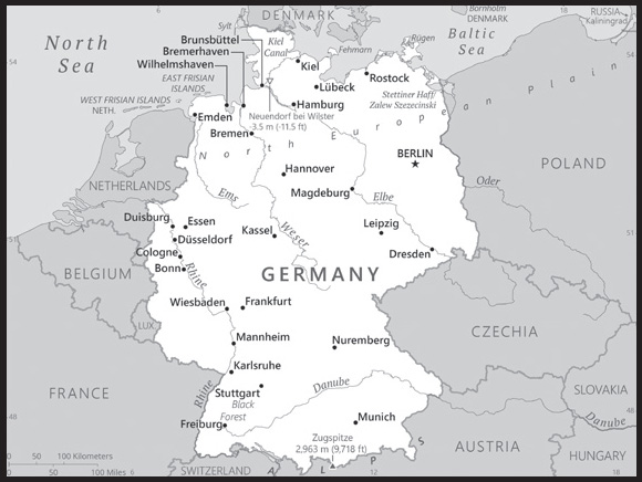
INTRODUCTION
Background: As Europe’s largest economy and second most populous nation (after Russia), Germany is a key member of the continent’s economic, political, and defense organizations. European power struggles immersed Germany in two devastating world wars in the first half of the 20th century and left the country occupied by the victorious Allied powers of the US, UK, France, and the Soviet Union in 1945. With the advent of the Cold War, two German states were formed in 1949: the western Federal Republic of Germany (FRG) and the eastern German Democratic Republic (GDR). The democratic FRG embedded itself in key western economic and security organizations, the EC (now the EU) and NATO, while the communist GDR was on the front line of the Soviet-led Warsaw Pact. The decline of the USSR and the end of the Cold War allowed for German reunification in 1990. Since then, Germany has expended considerable funds to bring eastern productivity and wages up to western standards. In January 1999, Germany and 10 other EU countries introduced a common European exchange currency, the euro.
GEOGRAPHY
Location: Central Europe, bordering the Baltic Sea and the North Sea, between the Netherlands and Poland, south of Denmark
Geographic coordinates: 51 00 N, 9 00 E
Map references: Europe
Area: total: 357,022 sq km
land: 348,672 sq km
water: 8,350 sq km
comparison ranking: total 64
Area - comparative: three times the size of Pennsylvania; slightly smaller than Montana
Land boundaries: total: 3,694 km
border countries (9): Austria 801 km; Belgium 133 km; Czechia 704 km; Denmark 140 km; France 418 km; Luxembourg 128 km; Netherlands 575 km; Poland 447 km; Switzerland 348 km
Coastline: 2,389 km
Maritime claims: territorial sea: 12 nm
exclusive economic zone: 200 nm
continental shelf: 200-m depth or to the depth of exploitation
Climate: temperate and marine; cool, cloudy, wet winters and summers; occasional warm mountain (foehn) wind
Terrain: lowlands in north, uplands in center, Bavarian Alps in south
Elevation: highest point: Zugspitze 2,963 m
lowest point: Neuendorf bei Wilster -3.5 m
mean elevation: 263 m
Natural resources: coal, lignite, natural gas, iron ore, copper, nickel, uranium, potash, salt, construction materials, timber, arable land
Land use: agricultural land: 48% (2018 est.)
arable land: 34.1% (2018 est.)
permanent crops: 0.6% (2018 est.)
permanent pasture: 13.3% (2018 est.)
forest: 31.8% (2018 est.)
other: 20.2% (2018 est.)
Irrigated land: 5,056 sq km (2020)
Major lakes (area sq km): fresh water lake(s): Lake Constance (shared with Switzerland and Austria) - 540 sq km
salt water lake(s): Stettiner Haff/Zalew Szczecinski (shared with Poland) - 900 sq km
Major rivers (by length in km): Donau (Danube) river source (shared with Austria, Slovakia, Czechia, Hungary, Croatia, Serbia, Bulgaria, Ukraine, Moldova, and Romania [m]) - 2,888 km; Elbe river mouth (shared with Czechia [s]) - 1,252 km; Rhein (Rhine) (shared with Switzerland [s], France, and Netherlands [m]) - 1,233 km
note – [s] after country name indicates river source; [m] after country name indicates river mouth
Major watersheds (area sq km): Atlantic Ocean drainage: Rhine-Maas (198,735 sq km), (Black Sea) Danube (795,656 sq km)
Population distribution: second most populous country in Europe; a fairly even distribution throughout most of the country, with urban areas attracting larger and denser populations, particularly in the far western part of the industrial state of North Rhine-Westphalia
Natural hazards: flooding
Geography - note: strategic location on North European Plain and along the entrance to the Baltic Sea; most major rivers in Germany - the Rhine, Weser, Oder, Elbe - flow northward; the Danube, which originates in the Black Forest, flows eastward
PEOPLE AND SOCIETY
Population: 84,220,184 (2023 est.)
comparison ranking: 18
Nationality: noun: German(s)
adjective: German
Ethnic groups: German 86.3%, Turkish 1.8%, Polish 1%, Syrian 1%, Romanian 1%, other/stateless/unspecified 8.9% (2020 est.)
note: data represent population by nationality
Languages: German (official); note - Danish, Frisian, Sorbian, and Romani are official minority languages; Low German, Danish, North Frisian, Sater Frisian, Lower Sorbian, Upper Sorbian, and Romani are recognized as regional languages under the European Charter for Regional or Minority Languages
major-language sample(s):
Das World Factbook, die unverzichtbare Quelle für grundlegende Informationen. (German)
Religions: Roman Catholic 26%, Protestant 23.7%, Muslim 3.6%, other 4.8%, none 41.9% (2021 est.)
Age structure: 0-14 years: 13.75% (male 5,905,124/female 5,673,727)
15-64 years: 62.97% (male 26,934,889/female 26,097,401)
65 years and over: 23.28% (2023 est.) (male 8,784,872/female 10,824,171)
Dependency ratios: total dependency ratio: 56.4
youth dependency ratio: 21.7
elderly dependency ratio: 34.7
potential support ratio: 2.9 (2021 est.)
Median age: total: 47.8 years (2020)
male: 46.5 years
female: 49.1 years
comparison ranking: total 4
Population growth rate: -0.12% (2023 est.)
comparison ranking: 206
Birth rate: 9.02 births/1,000 population (2023 est.)
comparison ranking: 199
Death rate: 11.97 deaths/1,000 population (2023 est.)
comparison ranking: 15
Net migration rate: 1.78 migrant(s)/1,000 population (2023 est.)
comparison ranking: 51
Population distribution: second most populous country in Europe; a fairly even distribution throughout most of the country, with urban areas attracting larger and denser populations, particularly in the far western part of the industrial state of North Rhine-Westphalia
Urbanization: urban population: 77.8% of total population (2023)
rate of urbanization: 0.13% annual rate of change (2020-25 est.)
Major urban areas - population: 3.574 million BERLIN (capital), 1.788 million Hamburg, 1.576 million Munich, 1.144 million Cologne, 796,000 Frankfurt (2023)
Sex ratio: at birth: 1.05 male(s)/female
0-14 years: 1.04 male(s)/female
15-64 years: 1.03 male(s)/female
65 years and over: 0.81 male(s)/female
total population: 0.98 male(s)/female (2023 est.)
Mother’s mean age at first birth: 29.9 years (2020 est.)
Maternal mortality ratio: 4 deaths/100,000 live births (2020 est.)
comparison ranking: 175
Infant mortality rate: total: 3.14 deaths/1,000 live births (2023 est.)
male: 3.51 deaths/1,000 live births
female: 2.76 deaths/1,000 live births
comparison ranking: total 208
Life expectancy at birth: total population: 81.72 years (2023 est.)
male: 79.37 years
female: 84.2 years
comparison ranking: total population 38
Total fertility rate: 1.58 children born/woman (2023 est.)
comparison ranking: 191
Gross reproduction rate: 0.77 (2023 est.)
Contraceptive prevalence rate: 67% (2018)
note: percent of women aged 18-49
Drinking water source: improved: total: 100% of population
unimproved: total: 0% of population (2020 est.)
Current health expenditure: 12.8% of GDP (2020)
Physicians density: 4.44 physicians/1,000 population (2020)
Hospital bed density: 8 beds/1,000 population (2017)
Sanitation facility access: improved: total: 100% of population
unimproved: total: 0% of population (2020 est.)
Obesity - adult prevalence rate: 22.3% (2016)
comparison ranking: 79
Alcohol consumption per capita: total: 10.56 liters of pure alcohol (2019 est.)
beer: 5.57 liters of pure alcohol (2019 est.)
wine: 3.02 liters of pure alcohol (2019 est.)
spirits: 1.97 liters of pure alcohol (2019 est.)
other alcohols: 0 liters of pure alcohol (2019 est.)
comparison ranking: total 19
Tobacco use: total: 22% (2020 est.)
male: 24.1% (2020 est.)
female: 19.9% (2020 est.)
comparison ranking: total 74
Children under the age of 5 years underweight: 0.5% (2014/17)
comparison ranking: 121
Currently married women (ages 15-49): 54.4% (2023 est.)
Education expenditures: 4.7% of GDP (2020 est.)
comparison ranking: 89
School life expectancy (primary to tertiary education): total: 17 years
male: 17 years
female: 17 years (2020)
Youth unemployment rate (ages 15-24): total: 7% (2021 est.)
male: 7.2%
female: 6.6%
comparison ranking: total 178
ENVIRONMENT
Environment - current issues: emissions from coal-burning utilities and industries contribute to air pollution; acid rain, resulting from sulfur dioxide emissions, is damaging forests; pollution in the Baltic Sea from raw sewage and industrial effluents from rivers in eastern Germany; hazardous waste disposal; government established a mechanism for ending the use of nuclear power by 2022; government working to meet EU commitment to identify nature preservation areas in line with the EU’s Flora, Fauna, and Habitat directive
Environment - international agreements: party to: Air Pollution, Air Pollution-Heavy Metals, Air Pollution-Multi-effect Protocol, Air Pollution-Nitrogen Oxides, Air Pollution-Persistent Organic Pollutants, Air Pollution-Sulphur 85, Air Pollution-Sulphur 94, Air Pollution-Volatile Organic Compounds, Antarctic-Environmental Protection, Antarctic-Marine Living Resources, Antarctic Seals, Antarctic Treaty, Biodiversity, Climate Change, Climate Change-Kyoto Protocol, Climate Change-Paris Agreement, Comprehensive Nuclear Test Ban, Desertification, Endangered Species, Environmental Modification, Hazardous Wastes, Law of the Sea, Marine Dumping-London Convention, Marine Dumping-London Protocol, Nuclear Test Ban, Ozone Layer Protection, Ship Pollution, Tropical Timber 2006, Wetlands, Whaling
signed, but not ratified: none of the selected agreements
Climate: temperate and marine; cool, cloudy, wet winters and summers; occasional warm mountain (foehn) wind
Land use: agricultural land: 48% (2018 est.)
arable land: 34.1% (2018 est.)
permanent crops: 0.6% (2018 est.)
permanent pasture: 13.3% (2018 est.)
forest: 31.8% (2018 est.)
other: 20.2% (2018 est.)
Urbanization: urban population: 77.8% of total population (2023)
rate of urbanization: 0.13% annual rate of change (2020-25 est.)
Revenue from forest resources: 0.03% of GDP (2018 est.)
comparison ranking: 137
Revenue from coal: 0.02% of GDP (2018 est.)
comparison ranking: 44
Air pollutants: particulate matter emissions: 10.73 micrograms per cubic meter (2019 est.)
carbon dioxide emissions: 727.97 megatons (2016 est.)
methane emissions: 49.92 megatons (2020 est.)
Waste and recycling: municipal solid waste generated annually: 51.046 million tons (2015 est.)
municipal solid waste recycled annually: 24,415,302 tons (2015 est.)
percent of municipal solid waste recycled: 47.8% (2015 est.)
Major lakes (area sq km): fresh water lake(s): Lake Constance (shared with Switzerland and Austria) - 540 sq km
salt water lake(s): Stettiner Haff/Zalew Szczecinski (shared with Poland) - 900 sq km
Major rivers (by length in km): Donau (Danube) river source (shared with Austria, Slovakia, Czechia, Hungary, Croatia, Serbia, Bulgaria, Ukraine, Moldova, and Romania [m]) - 2,888 km; Elbe river mouth (shared with Czechia [s]) - 1,252 km; Rhein (Rhine) (shared with Switzerland [s], France, and Netherlands [m]) - 1,233 km
note – [s] after country name indicates river source; [m] after country name indicates river mouth
Major watersheds (area sq km): Atlantic Ocean drainage: Rhine-Maas (198,735 sq km), (Black Sea) Danube (795,656 sq km)
Total water withdrawal: municipal: 10.4 billion cubic meters (2020 est.)
industrial: 17.68 billion cubic meters (2020 est.)
agricultural: 400 million cubic meters (2020 est.)
Total renewable water resources: 154 billion cubic meters (2020 est.)
GOVERNMENT
Country name: conventional long form: Federal Republic of Germany
conventional short form: Germany
local long form: Bundesrepublik Deutschland
local short form: Deutschland
former: German Reich
etymology: the Gauls (Celts) of Western Europe may have referred to the newly arriving Germanic tribes who settled in neighboring areas east of the Rhine during the first centuries B.C. as “Germani,” a term the Romans adopted as “Germania”; the native designation “Deutsch” comes from the Old High German “diutisc” meaning “of the people”
Government type: federal parliamentary republic
Capital: name: Berlin
geographic coordinates: 52 31 N, 13 24 E
time difference: UTC+1 (6 hours ahead of Washington, DC, during Standard Time)
daylight saving time: +1hr, begins last Sunday in March; ends last Sunday in October
etymology: the origin of the name is unclear but may be related to the old West Slavic (Polabian) word “berl” or “birl,” meaning “swamp”
Administrative divisions: 16 states (Laender, singular - Land); Baden-Wuerttemberg, Bayern (Bavaria), Berlin, Brandenburg, Bremen, Hamburg, Hessen (Hesse), Mecklenburg-Vorpommern (Mecklenburg-Western Pomerania), Niedersachsen (Lower Saxony), Nordrhein-Westfalen (North Rhine-Westphalia), Rheinland-Pfalz (Rhineland-Palatinate), Saarland, Sachsen (Saxony), Sachsen-Anhalt (Saxony-Anhalt), Schleswig-Holstein, Thueringen (Thuringia); note - Bayern, Sachsen, and Thueringen refer to themselves as free states (Freistaaten, singular - Freistaat), while Bremen calls itself a Free Hanseatic City (Freie Hansestadt) and Hamburg considers itself a Free and Hanseatic City (Freie und Hansestadt)
Independence: 18 January 1871 (establishment of the German Empire); divided into four zones of occupation (UK, US, USSR, and France) in 1945 following World War II; Federal Republic of Germany (FRG or West Germany) proclaimed on 23 May 1949 and included the former UK, US, and French zones; German Democratic Republic (GDR or East Germany) proclaimed on 7 October 1949 and included the former USSR zone; West Germany and East Germany unified on 3 October 1990; all four powers formally relinquished rights on 15 March 1991; notable earlier dates: 10 August 843 (Eastern Francia established from the division of the Carolingian Empire); 2 February 962 (crowning of OTTO I, recognized as the first Holy Roman Emperor)
National holiday: German Unity Day, 3 October (1990)
Constitution: history: previous 1919 (Weimar Constitution); latest drafted 10-23 August 1948, approved 12 May 1949, promulgated 23 May 1949, entered into force 24 May 1949
amendments: proposed by Parliament; passage and enactment into law require two-thirds majority vote by both the Bundesrat (upper house) and the Bundestag (lower house) of Parliament; articles including those on basic human rights and freedoms cannot be amended; amended many times, last in 2020; note - in early 2021, the German federal government introduced a bill to incorporate children’s rights into the constitution
Legal system: civil law system
International law organization participation: accepts compulsory ICJ jurisdiction with reservations; accepts ICCt jurisdiction
Citizenship: citizenship by birth: no
citizenship by descent only: at least one parent must be a German citizen or a resident alien who has lived in Germany at least 8 years
dual citizenship recognized: yes, but requires prior permission from government
residency requirement for naturalization: 8 years
Suffrage: 18 years of age; universal; age 16 for some state and municipal elections
Executive branch: chief of state: President Frank-Walter STEINMEIER (since 19 March 2017)
head of government: Chancellor Olaf SCHOLZ (since 8 December 2021)
cabinet: Cabinet or Bundesminister (Federal Ministers) recommended by the chancellor, appointed by the president
elections/appointments: president indirectly elected by a Federal Convention consisting of all members of the Federal Parliament (Bundestag) and an equivalent number of delegates indirectly elected by the state parliaments; president serves a 5-year term (eligible for a second term); election last held on 13 February 2022 (next to be held in February 2027); following the most recent Federal Parliament election, the party or coalition with the most representatives usually elects the chancellor who is appointed by the president to serve a renewable 4-year term; Federal Parliament vote for chancellor last held on 8 December 2021 (next to be held after the Bundestag election in 2025)
election results:
2017: Frank-Walter STEINMEIER reelected president; Federal Convention vote count - Frank-Walter STEINMEIER (SPD) 1,045, Max OTTE (CDU) 140, Gerhard TRABERT (The Left) 96, Stefanie GEBAUER (Free Voters) 58, abstentions 86; Olaf SCHOLZ (SPD) elected chancellor; Federal Parliament vote - 395 to 303
2012: Joachim GAUCK elected president; Federal Convention vote count - Joachim GAUCK (Independent) 911, Beate KLARSFELD (The Left) 126, Olaf ROSE 3
Legislative branch: description: bicameral Parliament or Parlament consists of:
Federal Council or Bundesrat (69 seats statutory, 71 current; members appointed by each of the 16 state governments)
Federal Diet or Bundestag (736 seats statutory, 736 for the 2021-25 term - total seats can vary each electoral term; currently includes 4 seats for independent members; approximately one-half of members directly elected in multi-seat constituencies by proportional representation vote and approximately one-half directly elected in single-seat constituencies by simple majority vote; members’ terms depend upon the states they represent)
elections:
Bundesrat - none; determined by the composition of the state-level governments; the composition of the Bundesrat has the potential to change any time one of the 16 states holds an election
Bundestag - last held on 26 September 2021 (next to be held in September 2025 at the latest); almost all postwar German governments have been coalitions
election results:
Bundesrat - composition - men 46, women 23, percent of women 33.3%
Bundestag - percent of vote by party - SPD 28%, CDU/CSU 26.8%, Alliance ‘90/Greens 16%, FDP 12.5%, AfD 11%, The Left 5.3%, other .04%; seats by party - SPD 206, CDU/CSU 197, Alliance ‘90/Greens 118, FDP 92, AfD 81, The Left 39, other 3; composition - men 479, women 257, percent of women 34.9%; note - total Parliament percent of women 34.8%
note: due to Germany’s recognition of the concepts of “overhang” (when a party’s share of the nationwide votes would entitle it to fewer seats than the number of individual constituency seats won in an election under Germany’s mixed member proportional system) and “leveling” (whereby additional seats are elected to supplement the members directly elected by each constituency in order to ensure that each party’s share of the total seats is roughly proportional to the party’s overall shares of votes at the national level), the 20th Bundestag is the largest to date
Judicial branch: highest court(s): Federal Court of Justice (court consists of 127 judges, including the court president, vice presidents, presiding judges, other judges and organized into 25 Senates subdivided into 12 civil panels, 5 criminal panels, and 8 special panels); Federal Constitutional Court or Bundesverfassungsgericht (consists of 2 Senates each subdivided into 3 chambers, each with a chairman and 8 members)
judge selection and term of office: Federal Court of Justice judges selected by the Judges Election Committee, which consists of the Secretaries of Justice from each of the 16 federated states and 16 members appointed by the Federal Parliament; judges appointed by the president; judges serve until mandatory retirement at age 65; Federal Constitutional Court judges - one-half elected by the House of Representatives and one-half by the Senate; judges appointed for 12- year terms with mandatory retirement at age 68
subordinate courts: Federal Administrative Court; Federal Finance Court; Federal Labor Court; Federal Social Court; each of the 16 federated states or Land has its own constitutional court and a hierarchy of ordinary (civil, criminal, family) and specialized (administrative, finance, labor, social) courts; two English-speaking commercial courts opened in late 2020 in the state of Baden-Wuerttemberg - English-speaking Stuttgart Commercial Court and English-speaking Mannheim Commercial Court
Political parties and leaders: Alliance ‘90/Greens [Ricarda LANG and Omid NOURIPOUR]
Alternative for Germany or AfD [Alice WEIDEL and Tino CHRUPALLA]
Christian Democratic Union or CDU [Friedrich MERZ]
Christian Social Union or CSU [Markus SOEDER]
Free Democratic Party or FDP [Christian LINDNER]
Free Voters [Hubert AIWANGER]
The Left or Die Linke [Janine WISSLER and Martin SCHIRDEWAN]
Social Democratic Party or SPD [Saskia ESKEN and Lars KLINGBEIL]
International organization participation: ADB (nonregional member), AfDB (nonregional member), Arctic Council (observer), Australia Group, BIS, BSEC (observer), CBSS, CD, CDB, CE, CERN, EAPC, EBRD, ECB, EIB, EITI (implementing country), EMU, ESA, EU, FAO, FATF, G-5, G-7, G-8, G-10, G-20, IADB, IAEA, IBRD, ICAO, ICC (national committees), ICCt, ICRM, IDA, IEA, IFAD, IFC, IFRCS, IGAD (partners), IHO, ILO, IMF, IMO, IMSO, Interpol, IOC, IOM, IPU, ISO, ITSO, ITU, ITUC (NGOs), MIGA, MINURSO, MINUSMA, NATO, NEA, NSG, OAS (observer), OECD, OPCW, OSCE, Pacific Alliance (observer), Paris Club, PCA, Schengen Convention, SELEC (observer), SICA (observer), UN, UNAMID, UNCTAD, UNESCO, UNHCR, UNHRC, UNIDO, UNIFIL, UNMISS, UNRWA, UNSOM, UNWTO, UPU, Wassenaar Arrangement, WCO, WHO, WIPO, WMO, WTO, ZC
Diplomatic representation in the US: chief of mission: Ambassador Andreas MICHAELIS (since 15 September 2023)
chancery: 4645 Reservoir Road NW, Washington, DC 20007
telephone: [1] (202) 298-4000
FAX: [1] (202) 298-4261
email address and website:
https://www.germany.info/us-en
consulate(s) general: Atlanta, Boston, Chicago, Houston, Los Angeles, Miami, New York, San Francisco
Diplomatic representation from the US: chief of mission: Ambassador Amy GUTMANN (since 17 February 2022)
embassy: Pariser Platz 2, 10117 Berlin
Clayallee 170, 14191 Berlin (administrative services)
mailing address: 5090 Berlin Place, Washington DC 20521-5090
telephone: [49] (30) 8305-0
FAX: [49] (30) 8305-1215
email address and website:
consulate(s) general: Dusseldorf, Frankfurt am Main, Hamburg, Leipzig, Munich
Flag description: three equal horizontal bands of black (top), red, and gold; these colors have played an important role in German history and can be traced back to the medieval banner of the Holy Roman Emperor - a black eagle with red claws and beak on a gold field
National symbol(s): eagle; national colors: black, red, yellow
National anthem: name: “Das Lied der Deutschen” (Song of the Germans)
lyrics/music: August Heinrich HOFFMANN VON FALLERSLEBEN/Franz Joseph HAYDN
note: adopted 1922; the anthem, also known as “Deutschlandlied” (Song of Germany), was originally adopted for its connection to the March 1848 liberal revolution; following appropriation by the Nazis of the first verse, specifically the phrase, “Deutschland, Deutschland ueber alles” (Germany, Germany above all) to promote nationalism, it was banned after 1945; in 1952, its third verse was adopted by West Germany as its national anthem; in 1990, it became the national anthem for the reunited Germany
National heritage: total World Heritage Sites: 52 (49 cultural, 3 natural)
selected World Heritage Site locales: Museumsinsel (Museum Island), Berlin (c); Palaces and Parks of Potsdam and Berlin (c); Speyer Cathedral (c); Upper Middle Rhine Valley (c); Aachen Cathedral (c); Bauhaus and its Sites in Weimar, Dessau, and Bernau (c); Caves and Ice Age Art in the Swabian Jura (c); Mines of Rammelsberg, Historic Town of Goslar, and Upper Harz Water Management System (c); Roman Monuments, Cathedral of St. Peter, and Church of Our Lady in Trier (c); Hanseatic City of Lübeck (c); Old Town of Regensburg (c); Messel Pit Fossil Site (n)
ECONOMY
Economic overview: leading EU service-based export-driven economy; highly skilled and educated labor force; fairly fiscally conservative; energy-related economic disruptions due to Russian gas cessations; increased defense spending and rising debts
Real GDP (purchasing power parity): $4.424 trillion (2021 est.)
$4.311 trillion (2020 est.)
$4.477 trillion (2019 est.)
note: data are in 2017 dollars
comparison ranking: 5
Real GDP growth rate: 2.63% (2021 est.)
-3.7% (2020 est.)
1.06% (2019 est.)
comparison ranking: 151
Real GDP per capita: $53,200 (2021 est.)
$51,800 (2020 est.)
$53,900 (2019 est.)
note: data are in 2017 dollars
comparison ranking: 26
GDP (official exchange rate): $3,860,923,000,000 (2019 est.)
Inflation rate (consumer prices): 3.14% (2021 est.)
0.51% (2020 est.)
1.45% (2019 est.)
comparison ranking: 119
Credit ratings: Fitch rating: AAA (1994)
Moody’s rating: Aaa (1986)
Standard & Poors rating: AAA (1983)
note: The year refers to the year in which the current credit rating was first obtained. Credit ratings prior to 1989 refer to West Germany.
GDP - composition, by sector of origin: agriculture: 0.7% (2017 est.)
industry: 30.7% (2017 est.)
services: 68.6% (2017 est.)
comparison rankings: services 79; industry 73; agriculture 208
GDP - composition, by end use: household consumption: 53.1% (2017 est.)
government consumption: 19.5% (2017 est.)
investment in fixed capital: 20.4% (2017 est.)
investment in inventories: -0.5% (2017 est.)
exports of goods and services: 47.3% (2017 est.)
imports of goods and services: -39.7% (2017 est.)
Agricultural products: milk, pork, wheat, beef, potatoes, barley, rapeseeds, chicken, eggs, sugar beets
Industries: automotive, mechanical engineering, chemicals, electrical and batteries, manufacturing, metals, finance and banking, telecommunications, healthcare, retail
Industrial production growth rate: 3.61% (2021 est.)
comparison ranking: 108
Labor force: 43.968 million (2021 est.)
comparison ranking: 15
Labor force - by occupation: agriculture: 1.4%
industry: 24.2%
services: 74.3% (2016)
Unemployment rate: 3.54% (2021 est.)
3.81% (2020 est.)
3.14% (2019 est.)
comparison ranking: 187
Youth unemployment rate (ages 15-24): total: 7% (2021 est.)
male: 7.2%
female: 6.6%
comparison ranking: total 178
Population below poverty line: 14.8% (2018 est.)
Gini Index coefficient - distribution of family income: 31.7 (2018 est.)
comparison ranking: 137
Average household expenditures: on food: 10.7% of household expenditures (2018 est.)
on alcohol and tobacco: 3.2% of household expenditures (2018 est.)
Household income or consumption by percentage share: lowest 10%: 3.6%
highest 10%: 24% (2000)
Budget: revenues: $1.785 trillion (2020 est.)
expenditures: $1.945 trillion (2020 est.)
Budget surplus (+) or deficit (-): 1.3% (of GDP) (2017 est.)
comparison ranking: 26
Public debt: 63.9% of GDP (2017 est.)
67.9% of GDP (2016 est.)
note: general government gross debt is defined in the Maastricht Treaty as consolidated general government gross debt at nominal value, outstanding at the end of the year in the following categories of government liabilities (as defined in ESA95): currency and deposits (AF.2), securities other than shares excluding financial derivatives (AF.3, excluding AF.34), and loans (AF.4); the general government sector comprises the sub-sectors of central government, state government, local government and social security funds; the series are presented as a percentage of GDP and in millions of euros; GDP used as a denominator is the gross domestic product at current market prices; data expressed in national currency are converted into euro using end-of-year exchange rates provided by the European Central Bank
comparison ranking: 69
Taxes and other revenues: 10.55% (of GDP) (2020 est.)
comparison ranking: 190
Fiscal year: calendar year
Current account balance: $313.754 billion (2021 est.)
$274.2 billion (2020 est.)
$294.407 billion (2019 est.)
comparison ranking: 2
Exports: $2.004 trillion (2021 est.) note: data are in current year dollars
$1.676 trillion (2020 est.) note: data are in current year dollars
$1.816 trillion (2019 est.) note: data are in current year dollars
comparison ranking: 3
Exports - partners: United States 9%, China 8%, France 8%, Netherlands 6%, Italy 6% (2021)
Exports - commodities: cars and vehicle parts, packaged medicines, medical cultures and vaccines, aircraft, industrial machinery, medical instruments (2021)
Imports: $1.775 trillion (2021 est.) note: data are in current year dollars
$1.454 trillion (2020 est.) note: data are in current year dollars
$1.595 trillion (2019 est.) note: data are in current year dollars
comparison ranking: 3
Imports - partners: China 10%, Netherlands 10%, Poland 7%, Italy 6%, France 6% (2021)
Imports - commodities: cars and vehicle parts, medical cultures/vaccines, packaged medicines, crude petroleum, natural gas, computers (2021)
Reserves of foreign exchange and gold: $295.736 billion (31 December 2021 est.)
$268.409 billion (31 December 2020 est.)
$224.028 billion (31 December 2019 est.)
comparison ranking: 13
Debt - external: $5,671,463,000,000 (2019 est.)
$5,751,408,000,000 (2018 est.)
comparison ranking: 4
Exchange rates: euros (EUR) per US dollar -
Exchange rates: 0.845 (2021 est.)
0.876 (2020 est.)
0.893 (2019 est.)
0.847 (2018 est.)
0.885 (2017 est.)
ENERGY
Electricity access: electrification - total population: 100% (2021)
Electricity: installed generating capacity: 248.265 million kW (2020 est.)
consumption: 500.35 billion kWh (2020 est.)
exports: 66.931 billion kWh (2020 est.)
imports: 48.047 billion kWh (2020 est.)
transmission/distribution losses: 25.97 billion kWh (2020 est.)
comparison rankings: transmission/distribution losses 17; imports 2; exports 2; consumption 9; installed generating capacity 6
Electricity generation sources: fossil fuels: 40.5% of total installed capacity (2020 est.)
nuclear: 11.1% of total installed capacity (2020 est.)
solar: 9.2% of total installed capacity (2020 est.)
wind: 23.9% of total installed capacity (2020 est.)
hydroelectricity: 4.5% of total installed capacity (2020 est.)
tide and wave: 0.2% of total installed capacity (2020 est.)
geothermal: 0% of total installed capacity (2020 est.)
biomass and waste: 10.4% of total installed capacity (2020 est.)
note: as of April 2023, Germany has closed its three remaining nuclear power plants
Nuclear energy: Number of operational nuclear reactors: 0
Number of nuclear reactors under construction: 0
Net capacity of operational nuclear reactors: 0GW
Percent of total electricity production: 0%
Percent of total energy produced: 0%
Number of nuclear reactors permanently shut down: 33
Coal: production: 114.86 million metric tons (2020 est.)
consumption: 145.379 million metric tons (2020 est.)
exports: 2.317 million metric tons (2020 est.)
imports: 31.503 million metric tons (2020 est.)
proven reserves: 35.9 billion metric tons (2019 est.)
Petroleum: total petroleum production: 135,000 bbl/day (2021 est.)
refined petroleum consumption: 2,346,500 bbl/day (2019 est.)
crude oil and lease condensate exports: 0 bbl/day (2018 est.)
crude oil and lease condensate imports: 1,720,600 bbl/day (2018 est.)
crude oil estimated reserves: 115.2 million barrels (2021 est.)
Refined petroleum products - production: 2.158 million bbl/day (2017 est.)
comparison ranking: 9
Refined petroleum products - exports: 494,000 bbl/day (2017 est.)
comparison ranking: 17
Refined petroleum products - imports: 883,800 bbl/day (2017 est.)
comparison ranking: 9
Natural gas: production: 5.129 billion cubic meters (2020 est.)
consumption: 8.755 billion cubic meters (2020 est.)
exports: 0 cubic meters (2020 est.)
imports: 83.12 billion cubic meters (2020 est.)
proven reserves: 23.39 billion cubic meters (2021 est.)
Carbon dioxide emissions: 726.881 million metric tonnes of CO2 (2019 est.)
from coal and metallurgical coke: 218.636 million metric tonnes of CO2 (2019 est.)
from petroleum and other liquids: 316.064 million metric tonnes of CO2 (2019 est.)
from consumed natural gas: 192.181 million metric tonnes of CO2 (2019 est.)
comparison ranking: total emissions 6
Energy consumption per capita: 161.174 million Btu/person (2019 est.)
comparison ranking: 31
COMMUNICATIONS
Telephones - fixed lines: total subscriptions: 38.6 million (2021 est.)
subscriptions per 100 inhabitants: 46 (2021 est.)
comparison ranking: total subscriptions 4
Telephones - mobile cellular: total subscriptions: 106.4 million (2021 est.)
subscriptions per 100 inhabitants: 128 (2021 est.)
comparison ranking: total subscriptions 16
Telecommunication systems: general assessment: with one of Europe’s largest telecom markets, Germany hosts a number of significant operators which offer effective competition in the mobile and broadband sectors; the German mobile market is driven by mobile data, with the number of mobile broadband subscribers having increased rapidly in recent years; with LTE now effectively universally available, considerable progress has recently been made in building out 5G networks (2022)
domestic: 46 per 100 for fixed-line and 128 per 100 for mobile-cellular subscriptions (2021)
international: country code - 49; landing points for SeaMeWe-3, TAT-14, AC-1, CONTACT-3, Fehmarn Balt, C-Lion1, GC1, GlobalConnect-KPN, and Germany-Denmark 2 & 3 - submarine cables to Europe, Africa, the Middle East, Asia, Southeast Asia and Australia; as well as earth stations in the Inmarsat, Intelsat, Eutelsat, and Intersputnik satellite systems (2019)
Broadcast media: a mixture of publicly operated and privately owned TV and radio stations; 70 national and regional public broadcasters compete with nearly 400 privately owned national and regional TV stations; more than 90% of households have cable or satellite TV; hundreds of radio stations including multiple national radio networks, regional radio networks, and a large number of local radio stations
Internet country code: .de
Internet users: total: 75.53 million (2021 est.)
percent of population: 91% (2021 est.)
comparison ranking: total 11
Broadband - fixed subscriptions: total: 36,215,303 (2020 est.)
subscriptions per 100 inhabitants: 43 (2020 est.)
comparison ranking: total 5
TRANSPORTATION
National air transport system: number of registered air carriers: 20 (2020)
inventory of registered aircraft operated by air carriers: 1,113
annual passenger traffic on registered air carriers: 109,796,202 (2018)
annual freight traffic on registered air carriers: 7,969,860,000 (2018) mt-km
Civil aircraft registration country code prefix: D
Airports: 539 (2021)
comparison ranking: total 12
Airports - with paved runways: 318
civil airports: 49
military airports: 21
joint use (civil-military) airports: 6
other airports: 242
note: paved runways have a concrete or asphalt surface but not all have facilities for refueling, maintenance, or air traffic control; the length of a runway required for aircraft to safely operate depends on a number of factors including the type of aircraft, the takeoff weight (including passengers, cargo, and fuel), engine types, flap settings, landing speed, elevation of the airport, and average maximum daily air temperature; paved runways can reach a length of 5,000 m (16,000 ft.), but the “typical” length of a commercial airline runway is between 2,500-4,000 m (8,000-13,000 ft.)
Airports - with unpaved runways: 221
note: unpaved runways have a surface composition such as grass or packed earth and are most suited to the operation of light aircraft; unpaved runways are usually short, often less than 1,000 m (3,280 ft.) in length; airports with unpaved runways often lack facilities for refueling, maintenance, or air traffic control
Heliports: 23 (2021)
Pipelines: 37 km condensate, 26,985 km gas, 2,400 km oil, 4,479 km refined products, 8 km water (2013)
Railways: total: 39,379 km (2020) 20,942 km electrified
15 km 0.900-mm gauge, 24 km 0.750-mm gauge (2015)
comparison ranking: total 6
Roadways: total: 830,000 km (2022) 830,000 km
paved: 830,000 km (2022) (includes 13,155 km of expressways)
note: includes local roads
comparison ranking: total 10
Waterways: 7,300 km (2022) (Rhine River carries most goods; Main-Danube Canal links North Sea and Black Sea)
comparison ranking: 20
Merchant marine: total: 592 (2022)
by type: bulk carrier 1, container ship 72, general cargo 79, oil tanker 34, other 406
comparison ranking: total 38
Ports and terminals: major seaport(s):
Baltic Sea: Kiel, Rostock
North Sea: Bremerhaven, Brunsbuttel, Emden, Hamburg, Wilhelmshaven
oil terminal(s): Brunsbuttel Canal terminals
container port(s) (TEUs): Bremen/Bremerhaven (5,018,900), Hamburg (8,715,000) (2021)
LNG terminal(s) (import): Hamburg; Brunsbuettel (FSRU); Lubmin (FSRU); Wilhelmshaven (FSRU)
river port(s): Bremen (Weser); Bremerhaven (Geeste); Duisburg, Karlsruhe, Neuss-Dusseldorf (Rhine); Lubeck (Wakenitz); Brunsbuttel, Hamburg (Elbe)
Transportation - note: Germany operates one PC 5 or 6 class icebreaker based in the North Atlantic
note - PC indicates a Polar Class vessel: PC 5 - year-round operation in medium first-year ice which may include old ice inclusions (ice thickness up to 70-120 cm); PC 6 - summer/autumn operation in medium first-year ice which may include old ice inclusions (ice thickness up to 30-70 cm)
MILITARY AND SECURITY
Military and security forces: Federal Armed Forces (Bundeswehr): Army (Heer), Navy (Deutsche Marine, includes naval air arm), Air Force (Luftwaffe, includes air defense), Joint Support and Enabling Service (Streitkraeftebasis, SKB), Central Medical Service (Zentraler Sanitaetsdienst, ZSanDstBw), Cyber and Information Space Command (Kommando Cyber und Informationsraum, Kdo CIR) (2023)
note: responsibility for internal and border security is shared by the police forces of the 16 states, the Federal Criminal Police Office, and the Federal Police; the states’ police forces report to their respective interior ministries while the Federal Police forces report to the Federal Ministry of the Interior
Military expenditures: 1.6% of GDP (2023 est.)
1.5% of GDP (2022 est.)
1.5% of GDP (2021)
1.5% of GDP (2020)
1.4% of GDP (2019)
comparison ranking: 86
Military and security service personnel strengths: approximately 185,000 active-duty armed forces personnel (62,000 Army; 16,000 Navy; 27,000 Air Force; 20,000 Medical Service, 14,000 Cyber and Information Space Command; 45,000 other, including central staff, support, logistics, etc.) (2023)
Military equipment inventories and acquisitions: the German Federal Armed Forces inventory is comprised of weapons systems produced domestically or jointly with other European countries and Western imports, particularly from the US; in recent years, the US has been the leading foreign supplier; Germany’s defense industry is capable of manufacturing the full spectrum of air, land, and naval military weapons systems, and is one of the world’s leading arms exporters (2023)
Military service age and obligation: 17-23 years of age for voluntary military service for men and women (must have completed compulsory full-time education and have German citizenship); conscription ended July 2011; service obligation 7-23 months or 12 years; in July 2020, the government launched a new voluntary conscript initiative focused on homeland security tasks; volunteers serve for 7 months plus 5 months as reservists over a 6 year period (2023)
note: women have been eligible for voluntary service in all military branches and positions since 2001 and accounted for about 12% of the active-duty German military in 2023
Military deployments: up to 500 Iraq (NATO); up to 1,400 Lithuania (NATO); up to 1,000 Mali (MINUSMA/EUTM); 100 Niger; 280 Slovakia (NATO) (2023)
note 1: in November 2022, Germany pledged to withdraw its troops from Mali by Spring 2024
note 2: in response to Russia’s 2022 invasion of Ukraine, some NATO countries, including Germany, have sent additional troops and equipment to the battlegroups deployed in NATO territory in eastern Europe
Military - note: the Bundeswehr’s core mission is the defense of Germany and its NATO partners; it has a wide range of peacetime duties, including crisis management, cyber security, deterrence, homeland security, humanitarian and disaster relief, and international peacekeeping and stability operations; as a key member of NATO and the EU, the Bundeswehr typically operates in a coalition environment, and its capabilities are largely based on NATO and EU planning goals and needs; it has participated in a range of NATO and EU missions in Europe, Africa, and Asia, as well as global maritime operations; the Bundeswehr has close bilateral defense ties with a number of EU countries, including the Czechia, France, the Netherlands, and Romania, as well as the UK and the US; it also contributes forces to UN peacekeeping missions
the Bundeswehr was established in 1955; at the height of the Cold War in the 1980s, it had nearly 600,000 personnel, over 7,000 tanks, and 1,000 combat aircraft; in addition, over 400,000 soldiers from other NATO countries—including about 200,000 US military personnel—were stationed in West Germany; in the years following the collapse of the Soviet Union and the end of the Cold War, the Bundeswehr shrank by more than 60% in size (over 90% in tanks and about 80% in aircraft), while funding fell from nearly 3% of GDP and over 4% of government spending in the mid-1980s to 1.2% and 1.6% respectively; by the 2010s, Bundeswehr’s ability to fulfill its regional security commitments had deteriorated; the Russian annexation of Crimea in 2014 and full-scale assault on Ukraine in 2022 led to renewed emphasis on Germany’s leadership role in European defense and NATO and efforts to boost funding for the Bundeswehr to improve readiness, modernize, and expand
the current Bundeswehr Army is comprised of two armored divisions and a rapid forces division; the armored divisions have multiple armored and mechanized infantry brigades, including a Dutch brigade and a bi-national Franco-German brigade; one of the divisions also has a mountain infantry brigade; the rapid forces division has airborne, special operations, and helicopter forces, as well as a Dutch air mobile infantry brigade
the Navy is organized into flotillas for high seas and coastal operations; the high seas flotilla has 12 frigates, while the coastal flotilla has five corvettes and six submarines, plus mine warfare vessels, special operations forces, and marines; the marines cooperate closely with their Dutch counterparts, the Corps Mariniers, and together form a bi-national amphibious group; the Navy also has an aviation command for missions such as maritime surveillance, anti-submarine, and anti-surface warfare
the Air Force has commands for air, transport/logistics, and space operations; it has about 200 combat aircraft, plus dozens of aircraft for other missions, such as transport, tankers, electronic warfare, and reconnaissance, as well as more than 80 helicopters of various types (2023)
SPACE
Space agency/agencies: German Aerospace Center (Deutsches Zentrum für Luft- und Raumfahrt, DLR; established 1997); predecessor organization, German Test and Research Institute for Aviation and Space Flight, was established in 1969; note – the Federal Republic of Germany was allowed to research space flight after gaining sovereignty in 1955 (2023)
Space launch site(s): none; launched an initiative in 2020 with the aim of launching SLVs from a floating, mobile platform in the North Sea, with a logistics base in Bremerhaven (2023)
Space program overview: has one of Europe’s largest space programs; is a key member of the European Space Agency (ESA) and one of its largest contributors; builds and operates satellites, satellite/space launch vehicles (SLVs), space probes, unmanned orbiters, and reusable space planes; conducts research and develops a range of other space-related capabilities technologies, including satellite payloads (cameras, remote sensing, communications, optics, sensors, etc.), rockets and rocket propulsion, propulsion assisted landing technologies, and aeronautics; participates in ESA’s astronaut training program and human space flight operations and hosts the European Astronaut Center; participates in other international space programs, such as the International Space Station (ISS); hosts the mission control centers for the ISS and the ESA, as well as the European Organization for the Exploitation of Meteorological Satellites (EUMETSAT); in addition to ESA/EU and their member states, has ties to a range of foreign space programs, including those of China, Japan, Russia, and the US; has a robust commercial space industry sector that develops a broad range of space capabilities, including satellite launchers, and cooperates closely with DLR, ESA, and other international commercial entities and government agencies (2023)
note: further details about the key activities, programs, and milestones of the country’s space program, as well as government spending estimates on the space sector, appear in Appendix S
TERRORISM
Terrorist group(s): Terrorist group(s): Islamic Revolutionary Guard Corps/Qods Force; Islamic State of Iraq and ash-Sham (ISIS); al-Qa’ida
note: details about the history, aims, leadership, organization, areas of operation, tactics, targets, weapons, size, and sources of support of the group(s) appear(s) in Appendix-T
TRANSNATIONAL ISSUES
Disputes - international: none identified
Refugees and internally displaced persons: refugees (country of origin): 664,238 (Syria), 183,631 (Afghanistan), 151,254 (Iraq), 64,496 (Eritrea), 47,658 (Iran), 38,755 (Turkey), 32,155 (Somalia), 13,334 (Russia), 12,155 (Nigeria), 9,250 (Pakistan), 6,257 (Serbia and Kosovo), 6,912 (Ethiopia), 5,532 (Azerbaijan) (mid-year 2022); 1,114,070 (Ukraine) (as of 11 October 2023)
stateless persons: 28,941 (2022)
Illicit drugs: maritime transshipment point for cocaine heading for European drug; a major source of precursor or essential chemicals used in the production of illicit narcotics
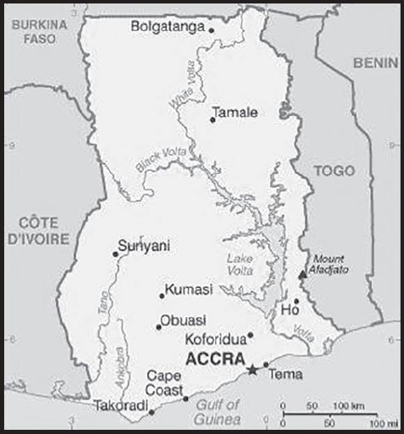
INTRODUCTION
Background: Ghana is a multiethnic country rich in natural resources and is one of the most stable and democratic countries in West Africa. Ghana has been inhabited for at least several thousand years, however, little is known about its early inhabitants. By the 12th century, the gold trade started to boom in Bono (Bonoman) state in what is today southern Ghana, and it became the genesis of Akan power and wealth in the region. Beginning in the 15th century, the Portuguese, followed by other European powers, arrived and contested for trading rights. Numerous kingdoms and empires emerged in the area, among the most powerful were the Kingdom of Dagbon in the north and the Asante (Ashanti) Empire in the south. By the mid-18th century, Asante was a highly organized state with immense wealth; it provided enslaved people for the Atlantic slave trade, and in return received firearms that facilitated its territorial expansion. The Asante resisted increasing British influence in the coastal areas, engaging in a series of wars during the 19th century before ultimately falling under British control. Formed from the merger of the British colony of the Gold Coast and the Togoland trust territory, Ghana in 1957 became the first Sub-Saharan country in colonial Africa to gain its independence, with Kwame NKRUMAH as its first leader.
Ghana endured a series of coups before Lt. Jerry RAWLINGS took power in 1981 and banned political parties. After approving a new constitution and restoring multiparty politics in 1992, RAWLINGS won presidential elections in 1992 and 1996 but was constitutionally prevented from running for a third term in 2000. John KUFUOR of the opposition New Patriotic Party (NPP) succeeded him and was reelected in 2004. John Atta MILLS of the National Democratic Congress won the 2008 presidential election and took over as head of state. MILLS died in July 2012 and was constitutionally succeeded by his vice president, John Dramani MAHAMA, who subsequently won the December 2012 presidential election. In 2016, Nana Addo Dankwa AKUFO-ADDO of the NPP defeated MAHAMA, marking the third time that Ghana’s presidency had changed parties since the return to democracy. AKUFO-ADDO was reelected in 2020. In recent years, Ghana has taken an active role in promoting regional stability and is highly integrated in international affairs.
GEOGRAPHY
Location: Western Africa, bordering the Gulf of Guinea, between Cote d’Ivoire and Togo
Geographic coordinates: 8 00 N, 2 00 W
Map references: Africa
Area: total: 238,533 sq km
land: 227,533 sq km
water: 11,000 sq km
comparison ranking: total 82
Area - comparative: slightly smaller than Oregon
Land boundaries: total: 2,420 km
border countries (3): Burkina Faso 602 km; Cote d’Ivoire 720 km; Togo 1098 km
Coastline: 539 km
Maritime claims: territorial sea: 12 nm
contiguous zone: 24 nm
exclusive economic zone: 200 nm
continental shelf: 200 nm
Climate: tropical; warm and comparatively dry along southeast coast; hot and humid in southwest; hot and dry in north
Terrain: mostly low plains with dissected plateau in south-central area
Elevation: highest point: Mount Afadjato 885 m
lowest point: Atlantic Ocean 0 m
mean elevation: 190 m
Natural resources: gold, timber, industrial diamonds, bauxite, manganese, fish, rubber, hydropower, petroleum, silver, salt, limestone
Land use: agricultural land: 69.1% (2018 est.)
arable land: 20.7% (2018 est.)
permanent crops: 11.9% (2018 est.)
permanent pasture: 36.5% (2018 est.)
forest: 21.2% (2018 est.)
other: 9.7% (2018 est.)
Irrigated land: 360 sq km (2013)
Major rivers (by length in km): Volta river mouth (shared with Burkina Faso [s]) - 1,600 km
note – [s] after country name indicates river source; [m] after country name indicates river mouth
Major watersheds (area sq km): Atlantic Ocean drainage: Volta (410,991 sq km)
Population distribution: population is concentrated in the southern half of the country, with the highest concentrations being on or near the Atlantic coast as shown in this population distribution map
Natural hazards: dry, dusty, northeastern harmattan winds from January to March; droughts
Geography - note: Lake Volta is the world’s largest artificial lake (manmade reservoir) by surface area (8,482 sq km; 3,275 sq mi); the lake was created following the completion of the Akosombo Dam in 1965, which holds back the White Volta and Black Volta Rivers
PEOPLE AND SOCIETY
Population: 33,846,114 (2023 est.)
comparison ranking: 44
Nationality: noun: Ghanaian(s)
adjective: Ghanaian
Ethnic groups: Akan 45.7%, Mole-Dagbani 18.5%, Ewe 12.8%, Ga-Dangme 7.1%, Gurma 6.4%, Guan 3.2%, Grusi 2.7%, Mande 2%, other 1.6% (2021 est.)
Languages: Asante 16%, Ewe 14%, Fante 11.6%, Boron (Brong) 4.9%, Dagomba 4.4%, Dangme 4.2%, Dagarte (Dagaba) 3.9%, Kokomba 3.5%, Akyem 3.2%, Ga 3.1%, other 31.2% (2010 est.)
note: English is the official language
Religions: Christian 71.3% (Pentecostal/Charismatic 31.6%, Protestant 17.4%, Catholic 10%, other 12.3%), Muslim 19.9%, traditionalist 3.2%, other 4.5%, none 1.1% (2021 est.)
Demographic profile: Ghana has a young age structure, with approximately 56% of the population under the age of 25 as of 2020. Its total fertility rate fell significantly during the 1980s and 1990s but has stalled at around four children per woman for the last few years. Fertility remains higher in the northern region than the Greater Accra region. On average, desired fertility has remained stable for several years; urban dwellers want fewer children than rural residents. Increased life expectancy, due to better health care, nutrition, and hygiene, and reduced fertility have increased Ghana’s share of elderly persons; Ghana’s proportion of persons aged 60+ is among the highest in Sub-Saharan Africa. Poverty has declined in Ghana, but it remains pervasive in the northern region, which is susceptible to droughts and floods and has less access to transportation infrastructure, markets, fertile farming land, and industrial centers. The northern region also has lower school enrollment, higher illiteracy, and fewer opportunities for women.
Ghana was a country of immigration in the early years after its 1957 independence, attracting labor migrants largely from Nigeria and other neighboring countries to mine minerals and harvest cocoa – immigrants composed about 12% of Ghana’s population in 1960. In the late 1960s, worsening economic and social conditions discouraged immigration, and hundreds of thousands of immigrants, mostly Nigerians, were expelled.
During the 1970s, severe drought and an economic downturn transformed Ghana into a country of emigration; neighboring Cote d’Ivoire was the initial destination. Later, hundreds of thousands of Ghanaians migrated to Nigeria to work in its booming oil industry, but most were deported in 1983 and 1985 as oil prices plummeted. Many Ghanaians then turned to more distant destinations, including other parts of Africa, Europe, and North America, but the majority continued to migrate within West Africa. Since the 1990s, increased emigration of skilled Ghanaians, especially to the US and the UK, drained the country of its health care and education professionals. Internally, poverty and other developmental disparities continue to drive Ghanaians from the north to the south, particularly to its urban centers.
Age structure: 0-14 years: 37.72% (male 6,445,288/female 6,321,989)
15-64 years: 57.92% (male 9,420,940/female 10,181,376)
65 years and over: 4.36% (2023 est.) (male 660,991/female 815,530)
Dependency ratios: total dependency ratio: 68.7
youth dependency ratio: 62.9
elderly dependency ratio: 5.9
potential support ratio: 17 (2021 est.)
Median age: total: 21.4 years (2020)
male: 21 years
female: 21.9 years
comparison ranking: total 184
Population growth rate: 2.19% (2023 est.)
comparison ranking: 35
Birth rate: 28.04 births/1,000 population (2023 est.)
comparison ranking: 33
Death rate: 5.99 deaths/1,000 population (2023 est.)
comparison ranking: 157
Net migration rate: -0.16 migrant(s)/1,000 population (2023 est.)
comparison ranking: 106
Population distribution: population is concentrated in the southern half of the country, with the highest concentrations being on or near the Atlantic coast as shown in this population distribution map
Urbanization: urban population: 59.2% of total population (2023)
rate of urbanization: 3.06% annual rate of change (2020-25 est.)
Major urban areas - population: 3.768 million Kumasi, 2.660 million ACCRA (capital), 1.078 million Sekondi Takoradi (2023)
Sex ratio: at birth: 1.03 male(s)/female
0-14 years: 1.02 male(s)/female
15-64 years: 0.93 male(s)/female
65 years and over: 0.81 male(s)/female
total population: 0.95 male(s)/female (2023 est.)
Mother’s mean age at first birth: 20.7 years (2014 est.)
note: data represents median age at first birth among women 25-49
Maternal mortality ratio: 263 deaths/100,000 live births (2020 est.)
comparison ranking: 34
Infant mortality rate: total: 31.87 deaths/1,000 live births (2023 est.)
male: 35.25 deaths/1,000 live births
female: 28.38 deaths/1,000 live births
comparison ranking: total 46
Life expectancy at birth: total population: 69.72 years (2023 est.)
male: 68.06 years
female: 71.44 years
comparison ranking: total population 178
Total fertility rate: 3.61 children born/woman (2023 est.)
comparison ranking: 33
Gross reproduction rate: 1.78 (2023 est.)
Contraceptive prevalence rate: 27.2% (2017/18)
Drinking water source: improved: urban: 98.7% of population
rural: 83.8% of population
total: 92.4% of population
unimproved: urban: 1.3% of population
rural: 16.2% of population
total: 7.6% of population (2020 est.)
Current health expenditure: 4% of GDP (2020)
Physicians density: 0.17 physicians/1,000 population (2020)
Hospital bed density: 0.9 beds/1,000 population (2011)
Sanitation facility access: improved: urban: 84.8% of population
rural: 52.8% of population
total: 71.1% of population
unimproved: urban: 15.2% of population
rural: 47.2% of population
total: 28.9% of population (2020 est.)
Major infectious diseases: degree of risk: very high (2023)
food or waterborne diseases: bacterial and protozoal diarrhea, hepatitis A, and typhoid fever
vectorborne diseases: malaria and dengue fever
water contact diseases: schistosomiasis
animal contact diseases: rabies
respiratory diseases: meningococcal meningitis
note: on 31 August 2023, the US Centers for Disease Control and Prevention (CDC) issued a Travel Alert for polio in Africa; Ghana is currently considered a high risk to travelers for circulating vaccine-derived polioviruses (cVDPV); vaccine-derived poliovirus (VDPV) is a strain of the weakened poliovirus that was initially included in oral polio vaccine (OPV) and that has changed over time and behaves more like the wild or naturally occurring virus; this means it can be spread more easily to people who are unvaccinated against polio and who come in contact with the stool or respiratory secretions, such as from a sneeze, of an “infected” person who received oral polio vaccine; the CDC recommends that before any international travel, anyone unvaccinated, incompletely vaccinated, or with an unknown polio vaccination status should complete the routine polio vaccine series; before travel to any high-risk destination, the CDC recommends that adults who previously completed the full, routine polio vaccine series receive a single, lifetime booster dose of polio vaccine
Obesity - adult prevalence rate: 10.9% (2016)
comparison ranking: 136
Alcohol consumption per capita: total: 1.59 liters of pure alcohol (2019 est.)
beer: 0.53 liters of pure alcohol (2019 est.)
wine: 0.05 liters of pure alcohol (2019 est.)
spirits: 0.39 liters of pure alcohol (2019 est.)
other alcohols: 0.61 liters of pure alcohol (2019 est.)
comparison ranking: total 137
Tobacco use: total: 3.5% (2020 est.)
male: 6.6% (2020 est.)
female: 0.3% (2020 est.)
comparison ranking: total 164
Children under the age of 5 years underweight: 12.6% (2017/18)
comparison ranking: 41
Currently married women (ages 15-49): 54.3% (2023 est.)
Child marriage: women married by age 15: 5%
women married by age 18: 19.3%
men married by age 18: 3.9% (2018 est.)
Education expenditures: 3.9% of GDP (2018 est.)
comparison ranking: 121
Literacy: definition: age 15 and over can read and write
total population: 79%
male: 83.5%
female: 74.5% (2018)
School life expectancy (primary to tertiary education): total: 12 years
male: 12 years
female: 12 years (2020)
Youth unemployment rate (ages 15-24): total: 9.6% (2021 est.)
male: 9.7%
female: 9.4%
comparison ranking: total 158
ENVIRONMENT
Environment - current issues: recurrent drought in north severely affects agricultural activities; deforestation; overgrazing; soil erosion; poaching and habitat destruction threaten wildlife populations; water pollution; inadequate supplies of potable water
Environment - international agreements: party to: Biodiversity, Climate Change, Climate Change-Kyoto Protocol, Climate Change-Paris Agreement, Comprehensive Nuclear Test Ban, Desertification, Endangered Species, Environmental Modification, Hazardous Wastes, Law of the Sea, Marine Dumping-London Protocol, Nuclear Test Ban, Ozone Layer Protection, Ship Pollution, Tropical Timber 2006, Wetlands, Whaling
signed, but not ratified: Marine Life Conservation
Climate: tropical; warm and comparatively dry along southeast coast; hot and humid in southwest; hot and dry in north
Land use: agricultural land: 69.1% (2018 est.)
arable land: 20.7% (2018 est.)
permanent crops: 11.9% (2018 est.)
permanent pasture: 36.5% (2018 est.)
forest: 21.2% (2018 est.)
other: 9.7% (2018 est.)
Urbanization: urban population: 59.2% of total population (2023)
rate of urbanization: 3.06% annual rate of change (2020-25 est.)
Revenue from forest resources: 3.51% of GDP (2018 est.)
comparison ranking: 21
Revenue from coal: 0% of GDP (2018 est.)
comparison ranking: 139
Air pollutants: particulate matter emissions: 46.04 micrograms per cubic meter (2019 est.)
carbon dioxide emissions: 16.67 megatons (2016 est.)
methane emissions: 22.75 megatons (2020 est.)
Waste and recycling: municipal solid waste generated annually: 3,538,275 tons (2005 est.)
Major rivers (by length in km): Volta river mouth (shared with Burkina Faso [s]) - 1,600 km
note – [s] after country name indicates river source; [m] after country name indicates river mouth
Major watersheds (area sq km): Atlantic Ocean drainage: Volta (410,991 sq km)
Total water withdrawal: municipal: 300 million cubic meters (2020 est.)
industrial: 100 million cubic meters (2020 est.)
agricultural: 1.07 billion cubic meters (2020 est.)
Total renewable water resources: 56.2 billion cubic meters (2020 est.)
GOVERNMENT
Country name: conventional long form: Republic of Ghana
conventional short form: Ghana
former: Gold Coast
etymology: named for the medieval West African kingdom of the same name but whose location was actually further north than the modern country
Government type: presidential republic
Capital: name: Accra
geographic coordinates: 5 33 N, 0 13 W
time difference: UTC 0 (5 hours ahead of Washington, DC, during Standard Time)
etymology: the name derives from the Akan word “nkran” meaning “ants,” and refers to the numerous anthills in the area around the capital
Administrative divisions: 16 regions; Ahafo, Ashanti, Bono, Bono East, Central, Eastern, Greater Accra, North East, Northern, Oti, Savannah, Upper East, Upper West, Volta, Western, Western North
Independence: 6 March 1957 (from the UK)
National holiday: Independence Day, 6 March (1957)
Constitution: history: several previous; latest drafted 31 March 1992, approved and promulgated 28 April 1992, entered into force 7 January 1993
amendments: proposed by Parliament; consideration requires prior referral to the Council of State, a body of prominent citizens who advise the president of the republic; passage of amendments to “entrenched” constitutional articles (including those on national sovereignty, fundamental rights and freedoms, the structure and authorities of the branches of government, and amendment procedures) requires approval in a referendum by at least 40% participation of eligible voters and at least 75% of votes cast, followed by at least two-thirds majority vote in Parliament, and assent of the president; amendments to non-entrenched articles do not require referenda; amended 1996
Legal system: mixed system of English common law and customary law
International law organization participation: has not submitted an ICJ jurisdiction declaration; accepts ICCt jurisdiction
Citizenship: citizenship by birth: no
citizenship by descent only: at least one parent or grandparent must be a citizen of Ghana
dual citizenship recognized: yes
residency requirement for naturalization: 5 years
Suffrage: 18 years of age; universal
Executive branch: chief of state: President Nana Addo Dankwa AKUFO-ADDO (since 7 January 2017); Vice President Mahamudu BAWUMIA (since 7 January 2017); the president is both chief of state and head of government
head of government: President Nana Addo Dankwa AKUFO-ADDO (since 7 January 2017); Vice President Mahamudu BAWUMIA (since 7 January 2017)
cabinet: Council of Ministers; nominated by the president, approved by Parliament
elections/appointments: president and vice president directly elected on the same ballot by absolute majority popular vote in 2 rounds if needed for a 4-year term (eligible for a second term); election last held on 7 December 2020 (next to be held in December 2024)
election results: Nana Addo Dankwa AKUFO-ADDO reelected president in the first round; percent of vote - Nana Addo Dankwa AKUFO-ADDO (NPP) 51.3%, John Dramani MAHAMA (NDC) 47.4%, other 1.3% (2020)
Legislative branch: description: unicameral Parliament (275 seats; members directly elected in single-seat constituencies by simple majority vote to serve 4-year terms)
elections: last held on 7 December 2020 (next to be held in December 2024)
election results: percent of vote by party - NA; seats by party (preliminary) - NPP 137, NDC 137, independent 1; composition - men 235, women 40, percent of women 14.5%
Judicial branch: highest court(s): Supreme Court (consists of the chief justice and 13 justices)
judge selection and term of office: chief justice appointed by the president in consultation with the Council of State (a small advisory body of prominent citizens) and with the approval of Parliament; other justices appointed by the president upon the advice of the Judicial Council (an 18-member independent body of judicial, military and police officials, and presidential nominees) and on the advice of the Council of State; justices can retire at age 60, with compulsory retirement at age 70
subordinate courts: Court of Appeal; High Court; Circuit Court; District Court; regional tribunals
Political parties and leaders: All Peoples Congress or APC [Hassan AYARIGA]
Convention People’s Party or CPP [Onsy Kwame NKRUMAH, acting]
Ghana Freedom Party or GFP [Akua DONKOR]
Ghana Union Movement or GUM [Christian Kwabena ANDREWS]
Great Consolidated Popular Party or GCPP [Henry Herbert LARTEY]
Liberal Party of Ghana or LPG [Kofi AKPALOO]
National Democratic Congress or NDC [John Dramani MAHAMA]
National Democratic Party or NDP [Nana Konadu Agyeman RAWLINGS]
New Patriotic Party or NPP [Nana Addo Dankwa AKUFO-ADDO]
People’s National Convention or PNC [Janet NABIA]
Progressive People’s Party or PPP [Paa Kwesi NDUOM]
United Front Party or UFP [Dr. Nana A. BOATENG]
United Progressive Party or UPP [Akwasi Addai ODIKE]
note: Ghana has more than 20 registered parties; included are those which participated in the 2020 general election
International organization participation: ACP, AfDB, ATMIS, AU, C, ECOWAS, EITI (compliant country), FAO, G-24, G-77, IAEA, IBRD, ICAO, ICC (national committees), ICCt, ICRM, IDA, IFAD, IFC, IFRCS, ILO, IMF, IMO, IMSO, Interpol, IOC, IOM, IPU, ISO, ITSO, ITU, ITUC (NGOs), MIGA, MINURSO, MINUSMA, MONUSCO, NAM, OAS (observer), OIF, OPCW, UN, UNAMID, UNCTAD, UNESCO, UNHCR, UNIDO, UNIFIL, UNISFA, UNMIL, UNMISS, UNOCI, UNSOM, UNWTO, UPU, WCO, WFTU (NGOs), WHO, WIPO, WMO, WTO
Diplomatic representation in the US: chief of mission: Ambassador Alima MAHAMA (since 7 July 2021)
chancery: 3512 International Drive NW, Washington, DC 20008
telephone: [1] (202) 686-4520
FAX: [1] (202) 686-4527
email address and website:
consulate(s) general: New York
Diplomatic representation from the US: chief of mission: Ambassador Virginia E. PALMER (since 16 June 2022)
embassy: No. 24, Fourth Circular Road, Cantonments, Accra, P.O. Box 2288, Accra
mailing address: 2020 Accra Place, Washington DC 20521-2020
telephone: [233] (0) 30-274-1000
email address and website:
Flag description: three equal horizontal bands of red (top), yellow, and green, with a large black five-pointed star centered in the yellow band; red symbolizes the blood shed for independence, yellow represents the country’s mineral wealth, while green stands for its forests and natural wealth; the black star is said to be the lodestar of African freedom
note: uses the popular Pan-African colors of Ethiopia; similar to the flag of Bolivia, which has a coat of arms centered in the yellow band
National symbol(s): black star, golden eagle; national colors: red, yellow, green, black
National anthem: name: “God Bless Our Homeland Ghana”
lyrics/music: unknown/Philip GBEHO
note: music adopted 1957, lyrics adopted 1966; the lyrics were changed twice, in 1960 when a republic was declared and after a 1966 coup
National heritage: total World Heritage Sites: 2 (both cultural)
selected World Heritage Site locales: Forts and Castles, Volta, Greater Accra, Central and Western Regions; Asante Traditional Buildings
ECONOMY
Economic overview: West African trade and agrarian economy; COVID-19 reversed nearly 4 decades of continuous growth; major diamond, gold, cocoa, and oil exporter; high public debts; financial and energy sector reform programs adding to fiscal pressures; high remittances
Real GDP (purchasing power parity): $178.455 billion (2021 est.)
$169.382 billion (2020 est.)
$168.516 billion (2019 est.)
note: data are in 2017 dollars
comparison ranking: 71
Real GDP growth rate: 5.36% (2021 est.)
0.51% (2020 est.)
6.51% (2019 est.)
comparison ranking: 84
Real GDP per capita: $5,400 (2021 est.)
$5,300 (2020 est.)
$5,300 (2019 est.)
note: data are in 2017 dollars
comparison ranking: 172
GDP (official exchange rate): $65.363 billion (2019 est.)
Inflation rate (consumer prices): 9.97% (2021 est.)
9.89% (2020 est.)
7.14% (2019 est.)
comparison ranking: 24
Credit ratings: Fitch rating: B (2013)
Moody’s rating: B3 (2015)
Standard & Poors rating: B- (2020)
note: The year refers to the year in which the current credit rating was first obtained.
GDP - composition, by sector of origin: agriculture: 18.3% (2017 est.)
industry: 24.5% (2017 est.)
services: 57.2% (2017 est.)
comparison rankings: services 141; industry 112; agriculture 52
GDP - composition, by end use: household consumption: 80.1% (2017 est.)
government consumption: 8.6% (2017 est.)
investment in fixed capital: 13.7% (2017 est.)
investment in inventories: 1.1% (2017 est.)
exports of goods and services: 43% (2017 est.)
imports of goods and services: -46.5% (2017 est.)
Agricultural products: cassava, yams, plantains, maize, oil palm fruit, taro, rice, cocoa, oranges, pineapples
Industries: mining, lumbering, light manufacturing, aluminum smelting, food processing, cement, small commercial ship building, petroleum
Industrial production growth rate: -0.8% (2021 est.)
comparison ranking: 167
Labor force: 14.095 million (2021 est.)
comparison ranking: 44
Labor force - by occupation: agriculture: 44.7%
industry: 14.4%
services: 40.9% (2013 est.)
Unemployment rate: 4.7% (2021 est.)
4.65% (2020 est.)
4.32% (2019 est.)
comparison ranking: 161
Youth unemployment rate (ages 15-24): total: 9.6% (2021 est.)
male: 9.7%
female: 9.4%
comparison ranking: total 158
Population below poverty line: 23.4% (2016 est.)
Gini Index coefficient - distribution of family income: 43.5 (2016 est.)
comparison ranking: 35
Average household expenditures: on food: 41.3% of household expenditures (2018 est.)
on alcohol and tobacco: 1% of household expenditures (2018 est.)
Household income or consumption by percentage share: lowest 10%: 2%
highest 10%: 32.8% (2006)
Budget: revenues: $9.492 billion (2018 est.)
expenditures: $14.062 billion (2018 est.)
Budget surplus (+) or deficit (-): -6% (of GDP) (2017 est.)
comparison ranking: 184
Public debt: 71.8% of GDP (2017 est.)
73.4% of GDP (2016 est.)
comparison ranking: 56
Taxes and other revenues: 11.34% (of GDP) (2020 est.)
comparison ranking: 184
Fiscal year: calendar year
Current account balance: -$2.541 billion (2021 est.)
-$2.134 billion (2020 est.)
-$1.864 billion (2019 est.)
comparison ranking: 165
Exports: $23.901 billion (2021 est.) note: data are in current year dollars
$22.077 billion (2020 est.) note: data are in current year dollars
$25.592 billion (2019 est.)
comparison ranking: 81
Exports - partners: Switzerland 23%, United Arab Emirates 12%, China 12%, India 9%, Netherlands 5% (2020)
Exports - commodities: gold, crude petroleum, cocoa products, cashews, manganese (2021)
Imports: $25.967 billion (2021 est.) note: data are in current year dollars
$24.545 billion (2020 est.) note: data are in current year dollars
$26.908 billion (2019 est.)
comparison ranking: 80
Imports - partners: China 42%, Netherlands 5%, United States 5%, India 5%, United Arab Emirates 3% (2020)
Imports - commodities: refined petroleum, cars, rice, delivery trucks, iron (2020)
Reserves of foreign exchange and gold: $9.917 billion (31 December 2021 est.)
$7.884 billion (31 December 2020 est.)
$7.563 billion (31 December 2019 est.)
comparison ranking: 78
Debt - external: $20.467 billion (2019 est.)
$17.885 billion (2018 est.)
comparison ranking: 93
Exchange rates: cedis (GHC) per US dollar -
Exchange rates: 5.806 (2021 est.)
5.596 (2020 est.)
5.217 (2019 est.)
4.585 (2018 est.)
4.351 (2017 est.)
ENERGY
Electricity access: population without electricity: 5 million (2020)
electrification - total population: 86.3% (2021)
electrification - urban areas: 95.2% (2021)
electrification - rural areas: 74% (2021)
Electricity: installed generating capacity: 5.312 million kW (2020 est.)
consumption: 13,107,757,000 kWh (2019 est.)
exports: 1.801 billion kWh (2020 est.)
imports: 58 million kWh (2020 est.)
transmission/distribution losses: 2.474 billion kWh (2019 est.)
comparison rankings: imports 113; exports 54; installed generating capacity 85; transmission/distribution losses 78; consumption 87
Electricity generation sources: fossil fuels: 63.8% of total installed capacity (2020 est.)
solar: 0.3% of total installed capacity (2020 est.)
hydroelectricity: 35.9% of total installed capacity (2020 est.)
biomass and waste: 0.1% of total installed capacity (2020 est.)
Coal: production: 0 metric tons (2020 est.)
consumption: 48,000 metric tons (2020 est.)
exports: 0 metric tons (2020 est.)
imports: 48,000 metric tons (2020 est.)
proven reserves: 0 metric tons (2019 est.)
Petroleum: total petroleum production: 185,700 bbl/day (2021 est.)
refined petroleum consumption: 98,000 bbl/day (2019 est.)
crude oil and lease condensate exports: 176,800 bbl/day (2018 est.)
crude oil and lease condensate imports: 3,900 bbl/day (2018 est.)
crude oil estimated reserves: 660 million barrels (2021 est.)
Refined petroleum products - production: 2,073 bbl/day (2015 est.)
comparison ranking: 104
Refined petroleum products - exports: 2,654 bbl/day (2015 est.)
comparison ranking: 100
Refined petroleum products - imports: 85,110 bbl/day (2015 est.)
comparison ranking: 59
Natural gas: production: 1,598,653,000 cubic meters (2019 est.)
consumption: 2,224,568,000 cubic meters (2019 est.)
exports: 0 cubic meters (2021 est.)
imports: 625.915 million cubic meters (2019 est.)
proven reserves: 22.653 billion cubic meters (2021 est.)
Carbon dioxide emissions: 18.093 million metric tonnes of CO2 (2019 est.)
from coal and metallurgical coke: 160,000 metric tonnes of CO2 (2019 est.)
from petroleum and other liquids: 13.569 million metric tonnes of CO2 (2019 est.)
from consumed natural gas: 4.364 million metric tonnes of CO2 (2019 est.)
comparison ranking: total emissions 88
Energy consumption per capita: 11.239 million Btu/person (2019 est.)
comparison ranking: 152
COMMUNICATIONS
Telephones - fixed lines: total subscriptions: 315,271 (2021 est.)
subscriptions per 100 inhabitants: 1 (2021 est.)
comparison ranking: total subscriptions 107
Telephones - mobile cellular: total subscriptions: 40,454,073 (2021 est.)
subscriptions per 100 inhabitants: 123 (2021 est.)
comparison ranking: total subscriptions 40
Telecommunication systems: general assessment: challenged by unreliable electricity and shortage of skilled labor, Ghana seeks to extend telecom services nationally; investment in fiber infrastructure and off-grid solutions provide data coverage to over 23 million people; launch of LTE has improved mobile data services, including m-commerce and banking; moderately competitive Internet market, most through mobile networks; international submarine cables, and terrestrial cables have improved Internet capacity; LTE services are widely available; the relatively high cost of 5G-compatible devices also inhibits most subscribers from migrating from 3G and LTE platforms (2022)
domestic: fixed-line data less than 1 per 100 subscriptions; mobile-cellular subscriptions 123 per 100 persons (2021)
international: country code - 233; landing points for the SAT-3/WASC, MainOne, ACE, WACS and GLO-1 fiber-optic submarine cables that provide connectivity to South and West Africa, and Europe; satellite earth stations - 4 Intelsat (Atlantic Ocean); microwave radio relay link to Panaftel system connects Ghana to its neighbors; GhanaSat-1 nanosatellite launched in 2017 (2017)
Broadcast media: state-owned TV station, 2 state-owned radio networks; several privately owned TV stations and a large number of privately owned radio stations; transmissions of multiple international broadcasters are accessible; several cable and satellite TV subscription services are obtainable
Internet country code: .gh
Internet users: total: 22.44 million (2021 est.)
percent of population: 68% (2021 est.)
comparison ranking: total 38
Broadband - fixed subscriptions: total: 78,371 (2020 est.)
subscriptions per 100 inhabitants: 0.3 (2020 est.)
comparison ranking: total 132
TRANSPORTATION
National air transport system: number of registered air carriers: 3 (2020)
inventory of registered aircraft operated by air carriers: 21
annual passenger traffic on registered air carriers: 467,438 (2018)
Civil aircraft registration country code prefix: 9G
Airports: 10 (2021)
comparison ranking: total 155
Airports - with paved runways: 7
note: paved runways have a concrete or asphalt surface but not all have facilities for refueling, maintenance, or air traffic control; the length of a runway required for aircraft to safely operate depends on a number of factors including the type of aircraft, the takeoff weight (including passengers, cargo, and fuel), engine types, flap settings, landing speed, elevation of the airport, and average maximum daily air temperature; paved runways can reach a length of 5,000 m (16,000 ft.), but the “typical” length of a commercial airline runway is between 2,500-4,000 m (8,000-13,000 ft.)
Airports - with unpaved runways: 3
note: unpaved runways have a surface composition such as grass or packed earth and are most suited to the operation of light aircraft; unpaved runways are usually short, often less than 1,000 m (3,280 ft.) in length; airports with unpaved runways often lack facilities for refueling, maintenance, or air traffic control
Pipelines: 681.3 km gas, 11.4 km oil, 435 km refined products (2022)
Railways: total: 947 km (2022)
narrow gauge: 947 km (2022) 1.067-m gauge
comparison ranking: total 92
Roadways: total: 65,725 km (2021)
paved: 14,948 km (2021)
unpaved: 50,777 km (2021)
urban: 28,480 km 27% total paved 73% total unpaved
comparison ranking: total 72
Waterways: 1,293 km (2011) (168 km for launches and lighters on Volta, Ankobra, and Tano Rivers; 1,125 km of arterial and feeder waterways on Lake Volta)
comparison ranking: 60
Merchant marine: total: 52 (2022)
by type: general cargo 7, oil tanker 3, other 42
comparison ranking: total 118
Ports and terminals: major seaport(s): Takoradi, Tema
MILITARY AND SECURITY
Military and security forces: Ghana Armed Forces: Army, Navy, Air Force (2023)
note: the Ghana Police Service is under the Ministry of the Interior
Military expenditures: 0.4% of GDP (2022 est.)
0.5% of GDP (2021 est.)
0.4% of GDP (2020 est.)
0.4% of GDP (2019 est.)
0.3% of GDP (2018 est.)
comparison ranking: 162
Military and security service personnel strengths: approximately 14,000 active personnel (10,000 Army; 2,000 Navy; 2,000 Air Force) (2023)
Military equipment inventories and acquisitions: the military’s inventory is a mix older and some newer Russian, Chinese, and Western equipment (2023)
Military service age and obligation: 18-27 years of age for voluntary military service, with basic education certificate; no conscription (2023)
Military deployments: 140 Mali (MINUSMA); 875 Lebanon (UNIFIL); 725 (plus about 275 police) South Sudan (UNMISS); 650 Sudan (UNISFA) (2023)
note: since sending a contingent of troops to the Congo in 1960, the military has been a regular contributor to African-and UN-sponsored peacekeeping missions
Military - note: the military’s primary missions are border defense, assisting with internal security, peacekeeping, and protecting the country’s territorial waters, particularly its offshore oil and gas infrastructure; it has benefited from cooperation with foreign partners, such as the UK and the US, and experience gained from participation in multiple international peacekeeping missions; the government in recent years has committed to an increase in funding for equipment acquisitions, including armor, mechanized, and special forces capabilities for the Army, light attack aircraft for the Air Force, and more modern coastal patrol vessels for the Navy; the Army’s primary combat forces include several battalions of light infantry, a motorized rapid reaction/presidential guard battalion, and small regiments of light armored reconnaissance and special forces; the Navy has 2 ocean-going patrol vessels, several coastal patrol craft, and a special forces unit, while the Air Force operates a few ground attack aircraft and multipurpose helicopters
in 2022, Ghana began beefing up its military presence in the north of the country against threats from the terrorist organization Jama’at Nasr al-Islam wal Muslimin (JNIM), a coalition of al-Qa’ida linked militant groups, which has conducted attacks in the neighboring countries of Burkina Faso, Cote d’Ivoire, and Togo; Ghana’s northern frontier with Burkina Faso is also an area with well-established smuggling routes, porous borders, and illegal gold mining; Ghana has also pushed an initiative to bolster security cooperation and intelligence sharing among Gulf of Guinea neighbors and Sahel countries
the military traces its origins to the Gold Coast Constabulary that was established in 1879 and renamed the Gold Coast Regiment in 1901; the Gold Coast Regiment was part of the West African Frontier Force (WAFF), a multi-regiment force formed by the British colonial office in 1900 to garrison the West African colonies of Gold Coast (Ghana), Nigeria (Lagos and the protectorates of Northern and Southern Nigeria), Sierra Leone, and Gambia; the WAFF served with distinction in both East and West Africa during World War I; in 1928, it received royal recognition and was re-named the Royal West African Frontier Force (RWAFF); the RWAFF went on to serve in World War II as part of the British 81st and 82nd (West African) divisions in the East Africa and Burma campaigns; following independence in 1957, the Gold Coast Regiment formed the basis for the new Ghanaian Army (2023)
SPACE
Space agency/agencies: Ghana Space Science and Technology Center (GSSTC; established 2011); note – the GSSTC is slated to become the Ghana Space Agency in 2023 (2023)
Space program overview: has a small, nascent space program focused on research in space sciences and exploiting remote sensing (RS) technology for natural resource management, weather forecasting, agriculture, and national security issues; relies on foreign imagery for analysis but seeks to develop its own RS satellite capabilities; one of Africa’s leaders in satellite dish research; trains aerospace scientists and engineers; has established relations on space-related issues with China, Japan, and South Africa; cooperating with Egypt, Kenya, Nigeria, Sudan, and Uganda to establish a joint satellite to monitor climate changes in the African continent; partner of the Square Kilometer Array (SKA) international astronomy initiative (2023)
note: further details about the key activities, programs, and milestones of the country’s space program, as well as government spending estimates on the space sector, appear Appendix S
TRANSNATIONAL ISSUES
Disputes - international: disputed maritime border with Cote d’Ivoire was resolved in 2017 through a decision of a Special Chamber of the International Tribunal for the Law of the Sea (ITLOS)
Illicit drugs: Ghana is a transit and destination point for illicit drugs trafficked from Asia and South America to other African countries, Europe, and to a lesser extent North America; not a significant source for drugs entering the United States; limited local consumption of controlled pharmaceuticals, cocaine, and heroin from Asia and South America; cannabis cultivated and produced in large quantities in most rural areas of Ghana