INTRODUCTION
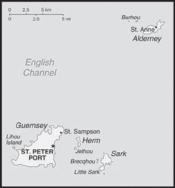
Background: Guernsey and the other Channel Islands represent the last remnants of the medieval Duchy of Normandy, which held sway in both France and England. The islands were the only British soil occupied by German troops in World War II. The Bailiwick of Guernsey consists of the main island of Guernsey and a number of smaller islands including Alderney, Sark, Herm, Jethou, Brecqhou, and Lihou. The Bailiwick is a self-governing British Crown dependency that is not part of the UK. However, the UK Government is constitutionally responsible for its defense and international representation.
GEOGRAPHY
Location: Western Europe, islands in the English Channel, northwest of France
Geographic coordinates: 49 28 N, 2 35 W
Map references: Europe
Area: total: 78 sq km
land: 78 sq km
water: 0 sq km
note: includes Alderney, Guernsey, Herm, Sark, and some other smaller islands
comparison ranking: total 227
Area - comparative: about one-half the size of Washington, DC
Land boundaries: total: 0 km
Coastline: 50 km
Maritime claims: territorial sea: 12 nm
exclusive fishing zone: 12 nm
Climate: temperate with mild winters and cool summers; about 50% of days are overcast
Terrain: mostly flat with low hills in southwest
Elevation: highest point: Le Moulin on Sark 114 m
lowest point: English Channel 0 m
Natural resources: Cropland
Natural hazards: very large tidal variation and fast currents can make local waters dangerous
Geography - note: large, deepwater harbor at Saint Peter Port
PEOPLE AND SOCIETY
Population: 67,642 (2023 est.)
comparison ranking: 203
Nationality: noun: Channel Islander(s)
adjective: Channel Islander
Ethnic groups: Guernsey 53.1%, UK and Ireland 23.9%, Portugal 2.2%, Latvia 1.5%, other Europe 2.8%, other 4.4%, unspecified 11.4% (2020 est.)
note: data represent population by country of birth; the native population is of British and Norman-French descent
Languages: English, French, Norman-French dialect spoken in country districts
Religions: Protestant (Anglican, Presbyterian, Baptist, Congregational, Methodist), Roman Catholic
Age structure: 0-14 years: 14.38% (male 5,006/female 4,722)
15-64 years: 64.48% (male 22,005/female 21,611)
65 years and over: 21.14% (2023 est.) (male 6,646/female 7,652)
Dependency ratios: total dependency ratio: 48.6
youth dependency ratio: 23.9
elderly dependency ratio: 24.6
potential support ratio: 4.1 (2021 est.)
note: data represent Guernsey and Jersey
Median age: total: 44.3 years (2020)
male: 43 years
female: 45.6 years
comparison ranking: total 17
Population growth rate: 0.22% (2023 est.)
comparison ranking: 175
Birth rate: 9.73 births/1,000 population (2023 est.)
comparison ranking: 190
Death rate: 9.17 deaths/1,000 population (2023 est.)
comparison ranking: 55
Net migration rate: 1.64 migrant(s)/1,000 population (2023 est.)
comparison ranking: 55
Urbanization: urban population: 31.2% of total population (2023)
rate of urbanization: 0.68% annual rate of change (2020-25 est.)
note: data include Guernsey and Jersey
Major urban areas - population: 16,000 SAINT PETER PORT (capital) (2018)
Sex ratio: at birth: 1.05 male(s)/female
0-14 years: 1.06 male(s)/female
15-64 years: 1.02 male(s)/female
65 years and over: 0.87 male(s)/female
total population: 0.99 male(s)/female (2023 est.)
Infant mortality rate: total: 3.3 deaths/1,000 live births (2023 est.)
male: 3.79 deaths/1,000 live births
female: 2.78 deaths/1,000 live births
comparison ranking: total 202
Life expectancy at birth: total population: 83.42 years (2023 est.)
male: 80.73 years
female: 86.24 years
comparison ranking: total population 12
Total fertility rate: 1.59 children born/woman (2023 est.)
comparison ranking: 188
Gross reproduction rate: 0.77 (2023 est.)
Drinking water source: improved: total: 94.2% of population
unimproved: total: 5.9% of population (2017 est.)
note: includes data for Jersey
Current health expenditure: NA
Sanitation facility access: improved:
total: 98% of population
unimproved: total: 1.2% of population (2017)
note: data represent Guernsey and Jersey
Youth unemployment rate (ages 15-24): total: 15.8% (2021 est.)
male: 15.9%
female: 15.6%
comparison ranking: total 110
ENVIRONMENT
Environment - current issues: coastal erosion, coastal flooding; declining biodiversity due to land abandonment and succession to scrub or woodland
Climate: temperate with mild winters and cool summers; about 50% of days are overcast
Urbanization: urban population: 31.2% of total population (2023)
rate of urbanization: 0.68% annual rate of change (2020-25 est.)
note: data include Guernsey and Jersey
Waste and recycling: municipal solid waste generated annually: 178,933 tons (2016 est.)
municipal solid waste recycled annually: 50,871 tons (2016 est.)
percent of municipal solid waste recycled: 28.4% (2016 est.)
note: data include combined totals for Guernsey and Jersey.
GOVERNMENT
Country name: conventional long form: Bailiwick of Guernsey
conventional short form: Guernsey
former: Norman Isles
etymology: the name is of Old Norse origin, but the meaning of the root “Guern(s)” is uncertain; the “-ey” ending means “island”
Government type: parliamentary democracy (States of Deliberation)
Dependency status: British crown dependency
Capital: name: Saint Peter Port
geographic coordinates: 49 27 N, 2 32 W
time difference: UTC 0 (5 hours ahead of Washington, DC, during Standard Time)
daylight saving time: +1hr, begins last Sunday in March; ends last Sunday in October
etymology: Saint Peter Port is the name of the town and its surrounding parish; the “port” distinguishes this parish from that of Saint Peter on the other side of the island
Administrative divisions: none (British Crown dependency); there are no first-order administrative divisions as defined by the US Government, but there are 10 parishes: Castel, Forest, Saint Andrew, Saint Martin, Saint Peter Port, Saint Pierre du Bois, Saint Sampson, Saint Saviour, Torteval, Vale
note: two additional parishes for Guernsey are sometimes listed - Saint Anne on the island of Alderney and Saint Peter on the island of Sark - but they are generally not included in the enumeration of parishes
Independence: none (British Crown dependency)
National holiday: Liberation Day, 9 May (1945)
Constitution: history: unwritten; includes royal charters, statutes, and common law and practice
amendments: new laws or changes to existing laws are initiated by the States of Deliberation; passage requires majority vote; many laws have been passed; in 2019, 60 laws were passed
Legal system: customary legal system based on Norman customary law; includes elements of the French civil code and English common law
Citizenship: see United Kingdom
Suffrage: 16 years of age; universal
Executive branch: chief of state: King CHARLES III (since 8 September 2022); represented by Lieutenant-Governor Richard CRIPWELL (since 15 February 2022)
head of government: Chief Minister Peter FERBRACHE (since 16 October 2020); Bailiff Richard McMAHON (since 11 May 2020); note - the chief minister is the president of the Policy and Resources Committee and is the de facto head of government; the Policy and Resources Committee, elected by the States of Deliberation, functions as the executive; the 5 members all have equal voting rights
cabinet: none
elections/appointments: the monarchy is hereditary; lieutenant governor and bailiff appointed by the monarch; chief minister, who is the president of the Policy and Resources Committee indirectly elected by the States of Deliberation for a 4-year term; last held on 7 October 2020 (next to be held in 2024)
election results:
2020: Peter FERBRACHE (independent) elected president of the Policy and Resources Committee and chief minister: percent of States of Guernsey vote - 57.5%
2016: Gavin ST. PIER (independent) elected president of the Policy and Resources Committee and chief minister
Legislative branch: description: unicameral States of Deliberation (40 seats; 38 People’s Deputies and 2 representatives of the States of Alderney; members directly elected by majority vote to serve 4-year terms); note - non-voting members include the bailiff (presiding officer), attorney-general, and solicitor-general
elections: last held on 7 October 2020 (next to be held in June 2025)
election results: percent of vote - independents 62.6%, GPI 24.0%, GP 10.0%, APG 3.4%; seats - independents 22, GPI 10, GP 6; composition - men 32, women 8, percent of women 20%
Judicial branch: highest court(s): Guernsey Court of Appeal (consists of the Bailiff of Guernsey, who is the ex-officio president of the Guernsey Court of Appeal, and at least 12 judges); Royal Court (organized into 3 divisions - Full Court sits with 1 judge and 7 to 12 jurats acting as judges of fact, Ordinary Court sits with 1 judge and normally 3 jurats, and Matrimonial Causes Division sits with 1 judge and 4 jurats); note - appeals beyond Guernsey courts are heard by the Judicial Committee of the Privy Council (in London)
judge selection and term of office: Royal Court Bailiff, Deputy Bailiff, and Court of Appeal justices appointed by the British Crown and hold office at Her Majesty’s pleasure; jurats elected by the States of Election, a body chaired by the Bailiff and a number of jurats
subordinate courts: Court of Alderney; Court of the Seneschal of Sark; Magistrates’ Court (includes Juvenile Court); Contracts Court; Ecclesiastical Court; Court of Chief Pleas
Political parties and leaders: Alliance Party Guernsey or APG [Barry WEIR]
Guernsey Partnership of Independents or GPI [Gavin ST PIER]
Guernsey Party or GP [Mark HEYLAR]
International organization participation: UPU
Diplomatic representation in the US: none (British crown dependency)
Diplomatic representation from the US: embassy: none (British crown dependency)
Flag description: white with the red cross of Saint George (patron saint of England) extending to the edges of the flag and a yellow equal- armed cross of William the Conqueror superimposed on the Saint George cross; the red cross represents the old ties with England and the fact that Guernsey is a British Crown dependency; the gold cross is a replica of the one used by William the Conqueror at the Battle of Hastings in 1066
National symbol(s): Guernsey cow, donkey; national colors: red, white, yellow
National anthem: name: “Sarnia Cherie” (Guernsey Dear)
lyrics/music: George DEIGHTON/Domencio SANTANGELO
note: adopted 1911; serves as a local anthem; as a British crown dependency, “God Save the King” is official (see United Kingdom)
ECONOMY
Economic overview: high-income English Channel island economy; strong financial sector but stressed due to COVID-19 disruptions; manufacturing, tourism, and construction industries suffered but expected to recover; stable inflation; maintains independent taxation authority
Real GDP (purchasing power parity): $3.465 billion (2015 est.)
$3.451 billion (2014 est.)
$3.42 billion (2013 est.)
note: data are in 2015 dollars
comparison ranking: 189
Real GDP growth rate: 0.4% (2015 est.)
1.2% (2014 est.)
4.2% (2012 est.)
comparison ranking: 189
Real GDP per capita: $52,500 (2014 est.)
comparison ranking: 27
GDP (official exchange rate): $2.742 billion (2005 est.)
Inflation rate (consumer prices): 6.8% (2022 est.)
3.4% (June 2006 est.)
note: data represent Retail Price Index inflation rates
comparison ranking: 112
GDP - composition, by sector of origin
agriculture: 3% (2000)
industry: 10% (2000)
services: 87% (2000)
comparison rankings: services 13; industry 206; agriculture 151
Agricultural products: tomatoes, greenhouse flowers, sweet peppers, eggplant, fruit; Guernsey cattle
Industries: tourism, banking
Labor force: 86,800 (2021 est.)
comparison ranking: 184
Unemployment rate: 7.37% (2021 est.)
7.69% (2020 est.)
6.41% (2019 est.)
comparison ranking: 107
Youth unemployment rate (ages 15-24): total: 15.8% (2021 est.)
male: 15.9%
female: 15.6%
comparison ranking: total 110
Budget: revenues: $563.6 million (2005)
expenditures: $530.9 million (2005 est.)
Budget surplus (+) or deficit (-): 1.2% (of GDP) (2005)
comparison ranking: 29
Taxes and other revenues: 20.6% (of GDP) (2005)
comparison ranking: 85
Fiscal year: calendar year
Exports - partners: almost entirely United Kingdom (2022)
Exports - commodities: aircraft, photo lab equipment, clocks, ships, paintings, scientific instruments (2022)
Imports - partners: almost entirely United Kingdom (2022)
Imports - commodities: ships, aircraft, refined petroleum, mineral manufactures, beverages (2022)
Exchange rates: Guernsey pound per US dollar
Exchange rates: 0.7836 (2017 est.)
0.738 (2016 est.)
0.738 (2015)
0.6542 (2014)
0.607 (2013)
ENERGY
Electricity access: electrification - total population: 100% (2021)
COMMUNICATIONS
Telephones - fixed lines: total subscriptions: 33,930 (2021 est.)
subscriptions per 100 inhabitants: 53 (2021 est.)
comparison ranking: total subscriptions 165
Telephones - mobile cellular: total subscriptions: 71,485 (2021 est.)
subscriptions per 100 inhabitants: 112 (2021 est.)
comparison ranking: total subscriptions 196
Telecommunication systems: general assessment: fixed network broadband services are those delivered over physical copper connections, fiber connections and fixed wireless communications links (e.g. WiMax); they do not include services delivered over 2G, 3G and 4G mobile networks (2021)
domestic: fixed-line 53 per 100 and mobile-cellular 112 per 100 persons (2021)
international: country code - 44; landing points for Guernsey-Jersey, HUGO, INGRID, Channel Islands -9 Liberty and UK-Channel Islands-7 submarine cable to UK and France (2019)
Broadcast media: multiple UK terrestrial TV broadcasts are received via a transmitter in Jersey with relays in Jersey, Guernsey, and Alderney; satellite packages are available; BBC Radio Guernsey and 1 other radio station operating
Internet country code: .gg
Internet users: total: 55,069 (2021 est.)
percent of population: 86.6% (2021 est.)
comparison ranking: total 200
Broadband - fixed subscriptions: total: 25,336 (2020 est.)
subscriptions per 100 inhabitants: 40 (2020 est.)
comparison ranking: total 158
TRANSPORTATION
National air transport system: number of registered air carriers: 1 (2020) (registered in UK)
inventory of registered aircraft operated by air carriers: 9 (registered in UK)
Civil aircraft registration country code prefix: 2
Airports: 2 (2021)
comparison ranking: total 205
Airports - with paved runways: 2
note: paved runways have a concrete or asphalt surface but not all have facilities for refueling, maintenance, or air traffic control; the length of a runway required for aircraft to safely operate depends on a number of factors including the type of aircraft, the takeoff weight (including passengers, cargo, and fuel), engine types, flap settings, landing speed, elevation of the airport, and average maximum daily air temperature; paved runways can reach a length of 5,000 m (16,000 ft.), but the “typical” length of a commercial airline runway is between 2,500-4,000 m (8,000-13,000 ft.)
Roadways: total: 260 km (2017)
comparison ranking: total 204
Ports and terminals: major seaport(s): Braye Bay, Saint Peter Port
MILITARY AND SECURITY
Military - note: defense is the responsibility of the UK
TRANSNATIONAL ISSUES
Disputes - international: none identified
Illicit drugs: NA
INTRODUCTION
Background: Guinea’s deep Muslim heritage arrived via the neighboring Almoravid Empire in the 11th century. Following Almoravid decline, Guinea existed on the fringe of several African kingdoms, all competing for regional dominance. In the 13th century, the Mali Empire took control of Guinea, encouraging its already growing Muslim faith. After the fall of the West African empires, various smaller kingdoms controlled Guinea. In the 18th century, Fulani Muslims established an Islamic state in central Guinea that represents one of the earliest examples of a written constitution and alternating leadership. While European traders first arrived in the 16th century, it was the French who secured colonial rule in the 19th century.
In 1958, Guinea achieved independence from France. Sekou TOURE became Guinea’s first post-independence president; he established a dictatorial regime and ruled until his death in 1984, after which General Lansana CONTE staged a coup and seized the government. He too established an authoritarian regime and manipulated presidential elections until his death in December 2008, when Captain Moussa Dadis CAMARA led a military coup, seized power, and suspended the constitution. In September 2009, presidential guards opened fire on an opposition rally, killing more than 150 people in Conakry, the capital. In early December 2009, CAMARA was wounded in an assassination attempt and exiled to Burkina Faso. In 2010 and 2013 respectively, the country held its first free and fair presidential and legislative elections. Alpha CONDE won the 2010 and 2015 presidential elections. CONDE’s first cabinet was the first all-civilian government in Guinean history. In March 2020, Guinea passed a new constitution in a national referendum that changed presidential term limit rules. CONDE argued that, given this change, he was allowed to run for a third term, which he then won in October 2020. On 5 September 2021, Col Mamady DOUMBOUYA led special forces troops in a successful military coup, ousting and detaining CONDE and establishing the National Committee for Reconciliation and Development (CNRD). DOUMBOUYA and the CNRD suspended the constitution and dissolved the government and the legislature. DOUMBOUYA was sworn in as transition president on 1 October 2021, and appointed Mohamed BEAVOGUI as transition prime minister a week later. BEAVOGUI subsequently formed a largely technocratic cabinet. The National Transition Council (CNT), which acts as the legislative body for the transition, was formed on 22 January 2022. The 81-member CNT is led by Dr. Dansa KOUROUMA and consists of appointed members representing a broad swath of Guinean society.
GEOGRAPHY
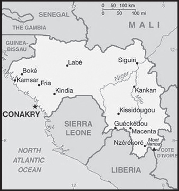
Location: Western Africa, bordering the North Atlantic Ocean, between Guinea-Bissau and Sierra Leone
Geographic coordinates: 11 00 N, 10 00 W
Map references: Africa
Area: total: 245,857 sq km
land: 245,717 sq km
water: 140 sq km
comparison ranking: total 79
Area - comparative: slightly smaller than Oregon; slightly larger than twice the size of Pennsylvania
Land boundaries: total: 4,046 km
border countries (6): Cote d’Ivoire 816 km; Guinea-Bissau 421 km; Liberia 590 km; Mali 1062 km; Senegal 363 km; Sierra Leone 794 km
Coastline: 320 km
Maritime claims: territorial sea: 12 nm
exclusive economic zone: 200 nm
Climate: generally hot and humid; monsoonal-type rainy season (June to November) with southwesterly winds; dry season (December to May) with northeasterly harmattan winds
Terrain: generally flat coastal plain, hilly to mountainous interior
Elevation: highest point: Mont Nimba 1,752 m
lowest point: Atlantic Ocean 0 m
mean elevation: 472 m
Natural resources: bauxite, iron ore, diamonds, gold, uranium, hydropower, fish, salt
Land use: agricultural land: 58.1% (2018 est.)
arable land: 11.8% (2018 est.)
permanent crops: 2.8% (2018 est.)
permanent pasture: 43.5% (2018 est.)
forest: 26.5% (2018 est.)
other: 15.4% (2018 est.)
Irrigated land: 950 sq km (2012)
Major rivers (by length in km): Niger river source (shared with Mali, and Nigeria [m]) - 4,200 km; Gambie (Gambia) river source (shared with Senegal and The Gambia [m]) - 1,094 km
note – [s] after country name indicates river source; [m] after country name indicates river mouth
Major watersheds (area sq km): Atlantic Ocean drainage: Niger (2,261,741 sq km), Senegal (456,397 sq km)
Population distribution: areas of highest density are in the west and south; interior is sparsely populated as shown in this population distribution map
Natural hazards: hot, dry, dusty harmattan haze may reduce visibility during dry season
Geography - note: the Niger and its important tributary the Milo River have their sources in the Guinean highlands
PEOPLE AND SOCIETY
Population: 13,607,249 (2023 est.)
comparison ranking: 75
Nationality: noun: Guinean(s)
adjective: Guinean
Ethnic groups: Fulani (Peuhl) 33.4%, Malinke 29.4%, Susu 21.2%, Guerze 7.8%, Kissi 6.2%, Toma 1.6%, other/foreign 0.4% (2018 est.)
Languages: French (official), Pular, Maninka, Susu, other native languages
note: about 40 languages are spoken; each ethnic group has its own language
Religions: Muslim 89.1%, Christian 6.8%, animist 1.6%, other 0.1%, none 2.4% (2014 est.)
Demographic profile: Guinea’s strong population growth is a result of declining mortality rates and sustained elevated fertility. The population growth rate was somewhat tempered in the 2000s because of a period of net outmigration. Although life expectancy and mortality rates have improved over the last two decades, the nearly universal practice of female genital cutting continues to contribute to high infant and maternal mortality rates. Guinea’s total fertility remains high at about 5 children per woman as of 2022 because of the ongoing preference for larger families, low contraceptive usage and availability, a lack of educational attainment and empowerment among women, and poverty. A lack of literacy and vocational training programs limit job prospects for youths, but even those with university degrees often have no option but to work in the informal sector. About 60% of the country’s large youth population is unemployed.
Tensions and refugees have spilled over Guinea’s borders with Sierra Leone, Liberia, and Cote d’Ivoire. During the 1990s Guinea harbored as many as half a million refugees from Sierra Leone and Liberia, more refugees than any other African country for much of that decade. About half sought refuge in the volatile “Parrot’s Beak” region of southwest Guinea, a wedge of land jutting into Sierra Leone near the Liberian border. Many were relocated within Guinea in the early 2000s because the area suffered repeated crossborder attacks from various government and rebel forces, as well as anti-refugee violence.
Age structure: 0-14 years: 40.96% (male 2,809,865/female 2,763,294)
15-64 years: 55.05% (male 3,741,047/female 3,749,281)
65 years and over: 4% (2023 est.) (male 245,323/female 298,439)
Dependency ratios: total dependency ratio: 82.4
youth dependency ratio: 76.3
elderly dependency ratio: 6.1
potential support ratio: 16.3 (2021 est.)
Median age: total: 19.1 years (2020)
male: 18.9 years
female: 19.4 years
comparison ranking: total 205
Population growth rate: 2.75% (2023 est.)
comparison ranking: 14
Birth rate: 35.47 births/1,000 population (2023 est.)
comparison ranking: 13
Death rate: 7.97 deaths/1,000 population (2023 est.)
comparison ranking: 91
Net migration rate: 0 migrant(s)/1,000 population (2023 est.)
comparison ranking: 92
Population distribution: areas of highest density are in the west and south; interior is sparsely populated as shown in this population distribution map
Urbanization: urban population: 38.1% of total population (2023)
rate of urbanization: 3.64% annual rate of change (2020-25 est.)
Major urban areas - population: 2.111 million CONAKRY (capital) (2023)
Sex ratio: at birth: 1.03 male(s)/female
0-14 years: 1.02 male(s)/female
15-64 years: 1 male(s)/female
65 years and over: 0.82 male(s)/female
total population: 1 male(s)/female (2023 est.)
Mother’s mean age at first birth: 19.9 years (2018 est.)
note: data represents median age at first birth among women 20-49
Maternal mortality ratio: 553 deaths/100,000 live births (2020 est.)
comparison ranking: 10
Infant mortality rate: total: 48.32 deaths/1,000 live births (2023 est.)
male: 52.98 deaths/1,000 live births
female: 43.51 deaths/1,000 live births
comparison ranking: total 19
Life expectancy at birth: total population: 64.27 years (2023 est.)
male: 62.38 years
female: 66.21 years
comparison ranking: total population 205
Total fertility rate: 4.82 children born/woman (2023 est.)
comparison ranking: 11
Gross reproduction rate: 2.37 (2023 est.)
Contraceptive prevalence rate: 10.9% (2018)
Drinking water source: improved: urban: 99.5% of population
rural: 76.9% of population
total: 85.2% of population
unimproved: urban: 0.5% of population
rural: 23.1% of population
total: 14.8% of population (2020 est.)
Current health expenditure: 4% of GDP (2020)
Physicians density: 0.23 physicians/1,000 population (2018)
Hospital bed density: 0.3 beds/1,000 population (2011)
Sanitation facility access: improved: urban: 90.9% of population
rural: 38.7% of population
total: 58% of population
unimproved: urban: 9.1% of population
rural: 61.3% of population
total: 42% of population (2020 est.)
Major infectious diseases: degree of risk: very high (2023)
food or waterborne diseases: bacterial and protozoal diarrhea, hepatitis A, and typhoid fever
vectorborne diseases: malaria and dengue fever
water contact diseases: schistosomiasis
animal contact diseases: rabies
aerosolized dust or soil contact diseases: Lassa fever
note: on 20 September 2023, the Centers for Disease Control and Prevention updated a Travel Health Alert for a diphtheria outbreak in several states in Guinea; vaccination against diphtheria is essential to protect against disease; if you are traveling to an affected area, you should be up to date with your diphtheria vaccines; before travel, discuss the need for a booster dose with your healthcare professional; diphtheria is a serious infection caused by strains of Corynebacterium diphtheriae bacteria that make a toxin from which people get very sick; diphtheria bacteria spread from person to person through respiratory droplets like from coughing or sneezing; people can also get sick from touching open sores or ulcers of people sick with diphtheria (see attached map)
Diphtheria outbreak in Guinea.: Obesity - adult prevalence rate
7.7% (2016)
comparison ranking: 158
Alcohol consumption per capita: total: 0.33 liters of pure alcohol (2019 est.)
beer: 0.29 liters of pure alcohol (2019 est.)
wine: 0.01 liters of pure alcohol (2019 est.)
spirits: 0.03 liters of pure alcohol (2019 est.)
other alcohols: 0 liters of pure alcohol (2019 est.)
comparison ranking: total 168
Children under the age of 5 years underweight: 16.3% (2018)
comparison ranking: 30
Currently married women (ages 15-49): 68.7% (2023 est.)
Child marriage: women married by age 15: 17%
women married by age 18: 46.5%
men married by age 18: 1.9% (2018 est.)
Education expenditures: 2.2% of GDP (2020 est.)
comparison ranking: 181
Literacy: definition: age 15 and over can read and write
total population: 45.3%
male: 61.2%
female: 31.3% (2021)
School life expectancy (primary to tertiary education): total: 9 years
male: 10 years
female: 8 years (2014)
Youth unemployment rate (ages 15-24): total: 8.2% (2021 est.)
male: 7%
female: 9.2%
comparison ranking: total 167
ENVIRONMENT
Environment - current issues: deforestation; inadequate potable water; desertification; soil contamination and erosion; overfishing, overpopulation in forest region; poor mining practices lead to environmental damage; water pollution; improper waste disposal
Environment - international agreements: party to: Biodiversity, Climate Change, Climate Change-Kyoto Protocol, Climate Change-Paris Agreement, Comprehensive Nuclear Test Ban, Desertification, Endangered Species, Hazardous Wastes, Law of the Sea, Ozone Layer Protection, Ship Pollution, Wetlands, Whaling
signed, but not ratified: none of the selected agreements
Climate: generally hot and humid; monsoonal-type rainy season (June to November) with southwesterly winds; dry season (December to May) with northeasterly harmattan winds
Land use: agricultural land: 58.1% (2018 est.)
arable land: 11.8% (2018 est.)
permanent crops: 2.8% (2018 est.)
permanent pasture: 43.5% (2018 est.)
forest: 26.5% (2018 est.)
other: 15.4% (2018 est.)
Urbanization: urban population: 38.1% of total population (2023)
rate of urbanization: 3.64% annual rate of change (2020-25 est.)
Food insecurity: severe localized food insecurity: due to reduced incomes - about 1.22 million people are projected to be in need of food assistance between June and August 2022, primarily due to food access constraints on account of the economic effects of the COVID-19 pandemic (2022)
Revenue from forest resources: 4.81% of GDP (2018 est.)
comparison ranking: 12
Revenue from coal: 0% of GDP (2018 est.)
comparison ranking: 114
Air pollutants: particulate matter emissions: 37.57 micrograms per cubic meter (2019 est.)
carbon dioxide emissions: 3 megatons (2016 est.)
methane emissions: 11.13 megatons (2020 est.)
Waste and recycling: municipal solid waste generated annually: 596,911 tons (1996 est.)
municipal solid waste recycled annually: 29,846 tons (2005 est.)
percent of municipal solid waste recycled: 5% (2005 est.)
Major rivers (by length in km): Niger river source (shared with Mali, and Nigeria [m]) - 4,200 km; Gambie (Gambia) river source (shared with Senegal and The Gambia [m]) - 1,094 km
note – [s] after country name indicates river source; [m] after country name indicates river mouth
Major watersheds (area sq km): Atlantic Ocean drainage: Niger (2,261,741 sq km), Senegal (456,397 sq km)
Total water withdrawal: municipal: 230 million cubic meters (2020 est.)
industrial: 60 million cubic meters (2020 est.)
agricultural: 600 million cubic meters (2020 est.)
Total renewable water resources: 226 billion cubic meters (2020 est.)
GOVERNMENT
Country name: conventional long form: Republic of Guinea
conventional short form: Guinea
local long form: Republique de Guinee
local short form: Guinee
former: French Guinea
etymology: the country is named after the Guinea region of West Africa that lies along the Gulf of Guinea and stretches north to the Sahel
Government type: presidential republic
Capital: name: Conakry
geographic coordinates: 9 30 N, 13 42 W
time difference: UTC 0 (5 hours ahead of Washington, DC, during Standard Time)
etymology: according to tradition, the name derives from the fusion of the name Cona, a Baga wine and cheese producer who lived on Tombo Island (the original site of the present-day capital), and the word nakiri, which in Susu means “the other bank” or “the other side”; supposedly, Baga’s palm grove produced the best wine on the island and people traveling to sample his vintage, would say: “I am going to Cona, on the other bank (Cona-nakiri),” which over time became Conakry
Administrative divisions: 7 regions administrative (administrative regions) and 1 gouvenorat (governorate)*; Boke, Conakry*, Faranah, Kankan, Kindia, Labe, Mamou, N’Zerekore
Independence: 2 October 1958 (from France)
National holiday: Independence Day, 2 October (1958)
Constitution: history: previous 1958, 1990; latest 2010, which was suspended on 5 September 2021 via a coup d’etat; on 27 September, the Transitional Charter was released, which supersedes the constitution until a new constitution is promulgated
amendments: proposed by the National Assembly or by the president of the republic; consideration of proposals requires approval by simple majority vote by the Assembly; passage requires approval in referendum; the president can opt to submit amendments directly to the Assembly, in which case approval requires at least two-thirds majority vote; revised in 2020
Legal system: civil law system based on the French model
International law organization participation: accepts compulsory ICJ jurisdiction with reservations; accepts ICCt jurisdiction
Citizenship: citizenship by birth: no
citizenship by descent only: at least one parent must be a citizen of Guinea
dual citizenship recognized: no
residency requirement for naturalization: na
Suffrage: 18 years of age; universal
Executive branch: chief of state: President Col. Mamady DOUMBOUYA (since 1 October 2021); note - on 5 September 2021, Col. Mamady DOUMBOUYA led a military coup in which President CONDE was arrested and detained, the constitution suspended, and the government and People’s National Assembly dissolved; on 1 October 2021, DOUMBOUYA was sworn in as transitional president
head of government: Prime Minister Bernard GOMOU (since 20 August 2022); note - GOMOU had been acting prime minister since 16 July 2022 replacing Mohamed BEAVOGui who stepped down due to health reasons
cabinet: formerly the Council of Ministers appointed by the president; note - on 5 September 2021, the military arrested and detained the president, suspended the constitution, and dissolved the government and legislature
elections/appointments: formerly, the president was directly elected by absolute majority popular vote in 2 rounds if needed for a 5-year term (eligible for a second term) and the prime minister appointed by the president; election last held on 18 October 2020; note - a new election time table has not been announced by the transitional government
election results:
note: following a military coup on 5 September 2021, coup leader Col. Mamady DOUMBOUYA was sworn in as transitional president on 1 October 2021
2020: Alpha CONDE reelected president in the first round; percent of vote - Alpha CONDE (RPG) 59.5%, Cellou Dalein DIALLO (UFDG) 33.5%, other 7%
Legislative branch: description: formerly the People’s National Assembly; note - on 5 September 2021, Col. Mamady DOUMBOUYA led a military coup in which President CONDE was arrested and detained, the constitution suspended, and the government and People’s National Assembly dissolved; on 22 January 2022, an 81-member Transitional National Council was installed
elections: 81 members to the Transitional National Council were appointed by the transitional president Col. Mamady DOUMBOUYA on 22 January 2022; elections for a permanent legislature had not been announced as of late January 2022
election results: 81 members of the National Transitional Council appointed on 22 January 2022 by the transitional president; the members represent all of the country’s socio-professional organizations and political parties
Judicial branch: highest court(s): Supreme Court or Cour Supreme (organized into Administrative Chamber and Civil, Penal, and Social Chamber; court consists of the first president, 2 chamber presidents, 10 councilors, the solicitor general, and NA deputies); Constitutional Court - suspended on 5 September 2021
judge selection and term of office: Supreme Court first president appointed by the national president after consultation with the National Assembly; other members appointed by presidential decree; members serve 9-year terms until age 65
subordinate courts: Court of Appeal or Cour d’Appel; High Court of Justice or Cour d’Assises; Court of Account (Court of Auditors); Courts of First Instance (Tribunal de Premiere Instance); labor court; military tribunal; justices of the peace; specialized courts
Political parties and leaders: African Congress for Democracy and Renewal or CADRE [Daniel KOLIE]
Alliance for National Renewal or ARN [Pepe Koulemou KOULEMOU]
Alliance for National Renewal or ARENA [Sekou Koureissy CONDE]
Bloc Liberal or BL [Faya MILLIMONO]
Citizen Generation or GECI [Mohamed SOUMAH]
Citizen Party for the Defense of Collective Interests or PCDIC [Hamidou BARRY]
Democratic Alliance for Renewal or ADR [Alpha Oumar Taran DIALLO]
Democratic National Movement or MND [Ousmane DORE]
Democratic Union for Renewal and Progress or UDRP [Edouard Zoutomou KPOGHOMOU]
Democratic Union of Guinea or UDG [Mamadou SYLLA]
Democratic People’s Movement of Guinea or MPDG [Siaka BARRY]
Democratic Workers’ Party of Guinea or PDTG [Talibi Dos CAMARA]
Front for the National Alliance or FAN [Makale CAMARA]
Generation for Reconciliation Union and Prosperity or GRUP [Papa Koly KOUROUMA]
Guinea for Democracy and Balance or GDE [Aboubacar SOUMAH]
Guinean Party for Peaceful Coexistence and Development or PGCD [Nene Moussa Maleya CAMARA]
Guinean Party for Solidarity and Democracy or PGSD [Elie KAMANO]
Guinean Union for Democracy and Development or uGdd [Francis HABA]
Guinean Rally for Development or RGD [Abdoul Kabele CAMARA]
Guinean Rally for Unity and Development or RGUD [Abraham BOURE]
Guinean Renaissance Party or PGR [Ibrahima Sory CONDE]
Modern Guinea [Thierno Yaya DIALLO]
Movement for Solidarity and Development or MSD [Abdoulaye DIALLO]
National Committee for Reconciliation and Development [Colonel Mamady DOUMBOUYA]
National Front for Development or FND [Alhousseine Makanera KAKE]
National Union for Prosperity or UNP [Alpha Mady SOUMAH]
National Party for Hope and Development or PEDN [Lansana KOUYATE]
New Democratic Forces or NFD [Mouctar DIALLO]
New Generation for the Republic or NGR [Abbe SYLLA]
New Guinea or NG [Mohamed CISSE]
New Political Generation or NGP [Badra KONE]
Party for Progress and Change or PPC [Aboubacar Biro SOUMAH]
Party of Citizen Action through Labor or PACT [Makale TRAORE]
Party of Democrats for Hope or PADES [Ousmane KABA]
Party of Freedom and Progress or PLP [Laye Souleymane DIALLO]
Party of Hope for National Development or PEDN [Lansana KOUYATE]
Rally for Renaissance and Development or RRD [Abdoulaye KOUROUMA]
Rally for the Guinean People or RPG (vacant)
Rally for the Integrated Development of Guinea or RDIG [Jean Marc TELIANO]
Rally for the Republic or RPR [Diabaty DORE]
Union for Progress and Renewal or UPR [Ousmane BAH]
Union for the Defense of Republican Interests or UDIR [Bouya KONATE]
Union for the Progress of Guinea or UPG [Jacques GBONIMY]
Union of Democratic Forces or UFD [Mamadou Baadiko BAH]
Union of Democratic Forces of Guinea or UFDG [Cellou Dalein DIALLO]
Union of Democrats for the Renaissance of Guinea or UDRG [Amadou Oury BAH]
Union of Republican Forces or UFR [Sidya TOURE]
Unity and Progress Party or PUP [Fode BANGOURA]
International organization participation: ACP, AfDB, EITI (compliant country), FAO, G-77, IBRD, ICAO, ICCt, ICRM, IDA, IDB, IFAD, IFC, IFRCS, ILO, IMF, IMO, Interpol, IOC, IOM, IPU, ISO (correspondent), ITSO, ITU, ITUC (NGOs), MIGA, MINURSO, MINUSMA, MONUSCO, NAM, OIC, OIF, OPCW, UN, UNCTAD, UNESCO, UNHCR, UNIDO, UNISFA, UNMISS, UNOCI, UNWTO, UPU, WCO, WFTU (NGOs), WHO, WIPO, WMO, WTO
Diplomatic representation in the US: chief of mission: Ambassador Fatoumata KABA (since 19 April 2023)
chancery: 2112 Leroy Place NW, Washington, DC 20008
telephone: [1] (202) 986-4300
FAX: [1] (202) 986-3800
email address and website:
http://guineaembassyusa.org/en/welcome-to-the-embassy-of-guinea-washington-usa/
Diplomatic representation from the US: chief of mission: Ambassador Troy Damian FITRELL (since January 2022)
embassy: Transversale No. 2, Centre Administratif de Koloma, Commune de Ratoma, Conakry
mailing address: 2110 Conakry Place, Washington DC 20521-2110
telephone: [224] 65-10-40-00
FAX: [224] 65-10-42-97
email address and website:
Flag description: three equal vertical bands of red (hoist side), yellow, and green; red represents the people’s sacrifice for liberation and work; yellow stands for the sun, for the riches of the earth, and for justice; green symbolizes the country’s vegetation and unity
note: uses the popular Pan-African colors of Ethiopia; the colors from left to right are the reverse of those on the flags of neighboring Mali and Senegal
National symbol(s): elephant; national colors: red, yellow, green
National anthem: name: “Liberte” (Liberty)
lyrics/music: unknown/Fodeba KEITA
note: adopted 1958
National heritage: total World Heritage Sites: 1 (natural)
selected World Heritage Site locales: Mount Nimba Strict Nature Reserve
ECONOMY
Economic overview: growing but primarily agrarian West African economy; major mining sector; improving fiscal and debt balances prior to COVID-19; economy increasingly vulnerable to climate change; slow infrastructure improvements; gender wealth and human capital gaps
Real GDP (purchasing power parity): $35.729 billion (2021 est.)
$34.388 billion (2020 est.)
$32.775 billion (2019 est.)
note: data are in 2017 dollars
comparison ranking: 131
Real GDP growth rate: 3.9% (2021 est.)
4.92% (2020 est.)
5.62% (2019 est.)
comparison ranking: 124
Real GDP per capita: $2,600 (2021 est.)
$2,600 (2020 est.)
$2,500 (2019 est.)
note: data are in 2017 dollars
comparison ranking: 201
GDP (official exchange rate): $13.55 billion (2019 est.)
Inflation rate (consumer prices): 12.6% (2021 est.)
10.6% (2020 est.)
9.47% (2019 est.)
comparison ranking: 19
GDP - composition, by sector of origin
agriculture: 19.8% (2017 est.)
industry: 32.1% (2017 est.)
services: 48.1% (2017 est.)
comparison rankings: services 188; industry 67; agriculture 50
GDP - composition, by end use: household consumption: 80.8% (2017 est.)
government consumption: 6.6% (2017 est.)
investment in fixed capital: 9.1% (2017 est.)
investment in inventories: 18.5% (2017 est.)
exports of goods and services: 21.9% (2017 est.)
imports of goods and services: -36.9% (2017 est.)
Agricultural products: rice, cassava, groundnuts, maize, oil palm fruit, fonio, plantains, sugar cane, sweet potatoes, vegetables
Industries: bauxite, gold, diamonds, iron ore; light manufacturing, agricultural processing
Industrial production growth rate: 3.9% (2021 est.)
comparison ranking: 106
Labor force: 4.89 million (2021 est.)
comparison ranking: 89
Labor force - by occupation: agriculture: 76%
industry: 24% (2006 est.)
Unemployment rate: 6.34% (2021 est.)
6.1% (2020 est.)
5.02% (2019 est.)
comparison ranking: 124
Youth unemployment rate (ages 15-24): total: 8.2% (2021 est.)
male: 7%
female: 9.2%
comparison ranking: total 167
Population below poverty line: 43.7% (2018 est.)
Gini Index coefficient - distribution of family income: 29.6 (2018 est.)
comparison ranking: 151
Household income or consumption by percentage share: lowest 10%: 2.7%
highest 10%: 30.3% (2007)
Budget: revenues: $1.949 billion (2019 est.)
expenditures: $2.014 billion (2019 est.)
Budget surplus (+) or deficit (-): -0.5% (of GDP) (2017 est.)
comparison ranking: 62
Public debt: 37.9% of GDP (2017 est.)
41.8% of GDP (2016 est.)
comparison ranking: 141
Taxes and other revenues: 16.6% (of GDP) (2017 est.)
comparison ranking: 127
Fiscal year: calendar year
Current account balance: $4.639 billion (2021 est.)
$2.685 billion (2020 est.)
-$314.62 million (2019 est.)
comparison ranking: 33
Exports: $10.266 billion (2021 est.) note: data are in current year dollars
$8.996 billion (2020 est.) note: data are in current year dollars
$4.041 billion (2019 est.)
comparison ranking: 103
Exports - partners: United Arab Emirates 39%, China 36%, India 6% (2019)
Exports - commodities: gold, aluminum ores and oxide, iron ores, cocoa beans, cashews, frozen fish (2021)
Imports: $5.353 billion (2021 est.) note: data are in current year dollars
$6.314 billion (2020 est.) note: data are in current year dollars
$4.32 billion (2019 est.)
comparison ranking: 141
Imports - partners: China 39%, India 8%, Netherlands 6%, Belgium 5%, United Arab Emirates 5% (2019)
Imports - commodities: rice, refined petroleum, packaged medicines, delivery trucks, cars (2019)
Reserves of foreign exchange and gold: $1.499 billion (31 December 2020 est.)
$1.379 billion (31 December 2019 est.)
$1.242 billion (31 December 2018 est.)
comparison ranking: 138
Debt - external: $1.458 billion (31 December 2017 est.)
$1.462 billion (31 December 2016 est.)
comparison ranking: 160
Exchange rates: Guinean francs (GNF) per US dollar -
Exchange rates: 9,565.082 (2020 est.)
9,183.876 (2019 est.)
9,011.134 (2018 est.)
9,088.319 (2017 est.)
8,967.927 (2016 est.)
ENERGY
Electricity access: population without electricity: 7 million (2020)
electrification - total population: 46.8% (2021)
electrification - urban areas: 89.8% (2021)
electrification - rural areas: 21.2% (2021)
Electricity: installed generating capacity: 992,000 kW (2020 est.)
consumption: 1.781 billion kWh (2019 est.)
exports: 0 kWh (2019 est.)
imports: 0 kWh (2019 est.)
transmission/distribution losses: 280 million kWh (2019 est.)
comparison rankings: installed generating capacity 135; transmission/distribution losses 141; imports 135; exports 118; consumption 149
Electricity generation sources: fossil fuels: 22.2% of total installed capacity (2020 est.)
solar: 0.7% of total installed capacity (2020 est.)
hydroelectricity: 77.1% of total installed capacity (2020 est.)
Petroleum: total petroleum production: 0 bbl/day (2021 est.)
refined petroleum consumption: 19,800 bbl/day (2019 est.)
Refined petroleum products - imports: 18,460 bbl/day (2015 est.)
comparison ranking: 128
Carbon dioxide emissions: 2.981 million metric tonnes of CO2 (2019 est.)
comparison ranking: total emissions 149
Energy consumption per capita: 4.133 million Btu/person (2019 est.)
comparison ranking: 173
COMMUNICATIONS
Telephones - fixed lines: total subscriptions: 0 (2018 est.)
subscriptions per 100 inhabitants: 0 (2018 est.)
comparison ranking: total subscriptions 223
Telephones - mobile cellular: total subscriptions: 13.795 million (2020 est.)
subscriptions per 100 inhabitants: 105 (2020 est.)
comparison ranking: total subscriptions 74
Telecommunication systems: general assessment: the number of mobile subscribers grew strongly while revenue also increased steadily; fixed broadband services are still very limited and expensive, though there have been some positive developments in recent years; the landing of the first international submarine cable in 2012, and the setting up of an IXP in mid-2013, increased the bandwidth available to the ISPs, and helped reduce the cost of internet services for end-users; a National Backbone Network was completed in mid-2020, connecting administrative centers across the country; almost all internet connections are made via mobile networks; GSM services account for a dwindling proportion of connections, in line with the greater reach of services based on 3G and LTE (2022)
domestic: fixed-line teledensity is less than 1 per 100 persons; mobile-cellular subscribership is just over 105 per 100 persons (2020)
international: country code - 224; ACE submarine cable connecting Guinea with 20 landing points in Western and South Africa and Europe; satellite earth station - 1 Intelsat (Atlantic Ocean (2019)
Broadcast media: Government maintains marginal control over broadcast media; single state-run TV station; state-run radio broadcast station also operates several stations in rural areas; a dozen private television stations; a steadily increasing number of privately owned radio stations, nearly all in Conakry, and about a dozen community radio stations; foreign TV programming available via satellite and cable subscription services
(2022)
Internet country code: .gn
Internet users: total: 4.9 million (2021 est.)
percent of population: 35% (2021 est.)
comparison ranking: total 93
Broadband - fixed subscriptions: total: 1,000 (2020 est.)
subscriptions per 100 inhabitants: 0.01 (2020 est.)
comparison ranking: total 203
TRANSPORTATION
Civil aircraft registration country code prefix: 3X
Airports: 16 (2021)
comparison ranking: total 143
Airports - with paved runways: 4
note: paved runways have a concrete or asphalt surface but not all have facilities for refueling, maintenance, or air traffic control; the length of a runway required for aircraft to safely operate depends on a number of factors including the type of aircraft, the takeoff weight (including passengers, cargo, and fuel), engine types, flap settings, landing speed, elevation of the airport, and average maximum daily air temperature; paved runways can reach a length of 5,000 m (16,000 ft.), but the “typical” length of a commercial airline runway is between 2,500-4,000 m (8,000-13,000 ft.)
Airports - with unpaved runways: 12
note: unpaved runways have a surface composition such as grass or packed earth and are most suited to the operation of light aircraft; unpaved runways are usually short, often less than 1,000 m (3,280 ft.) in length; airports with unpaved runways often lack facilities for refueling, maintenance, or air traffic control
Railways: total: 1,086 km (2017)
standard gauge: 279 km (2017) 1.435-m gauge
narrow gauge: 807 km (2017) 1.000-m gauge
comparison ranking: total 88
Roadways: total: 44,301 km (2018)
paved: 3,346 km (2018)
unpaved: 40,955 km (2018)
comparison ranking: total 84
Waterways: 1,300 km (2011) (navigable by shallow-draft native craft in the northern part of the Niger River system) comparison ranking: 58
Merchant marine: total: 3 (2022)
by type: general cargo 1, other 2
comparison ranking: total 172
Ports and terminals: major seaport(s): Conakry, Kamsar
MILITARY AND SECURITY
Military and security forces: National (or Guinean) Armed Forces: Army, Guinean Navy (Armee de Mer or Marine Guineenne), Guinean Air Force (Force Aerienne de Guinee), Presidential Security Battalion (Battailon Autonome de la Sécurité Presidentielle, BASP), Gendarmerie (2023)
note: the National Gendarmerie is overseen by the Ministry of Defense, while the National Police is under the Ministry of Security; the Gendarmerie and National Police share responsibility for internal security, but only the Gendarmerie can arrest police or military officials
Military expenditures: 1.8% of GDP (2022 est.)
1.5% of GDP (2021 est.)
1.4% of GDP (2020 est.)
1.6% of GDP (2019 est.)
1.8% of GDP (2018 est.)
comparison ranking: 68
Military and security service personnel strengths: approximately 12,000 active personnel, including about 1,500 Gendarmerie (2023)
Military equipment inventories and acquisitions: the inventory of the Guinean military consists largely of aging and outdated (mostly Soviet-era) equipment; in recent years, it has received small amounts of equipment from China, France, and South Africa (2023)
Military service age and obligation: 18 years of age for voluntary and selective conscripted service; 9-12 months of service (2023)
Military deployments: 670 Mali (MINUSMA) (2023)
Military - note: the Guinean military is a small and lightly armed force that is responsible for external defense, but also has some domestic security responsibilities and has historically been involved in suppressing public protests; the military has undergone some attempts at reform since 2010, but in 2021 the Army’s special forces led a successful coup; the Army has a mix of approximately 10 infantry, light armor, commando, and special forces battalions, as well as a presidential guard force; piracy and natural resource protection in the Gulf of Guinea are key areas of concern for the small Navy, which possesses only a few patrol boats; the Air Force has a handful of serviceable aircraft, including helicopter gunships (2023)
TRANSNATIONAL ISSUES
Disputes - international: Guinea-Liberia: the border is not disputed and there is joint border management, although the border is porous and there have been occasional disputes relating to military encroachments and use of the boundary rivers
Guinea-Mali: the border is not disputed, although there have been periodic clashes between border communities over land rights and access to natural resources
Illicit drugs: NA
INTRODUCTION
Background: For much of its history, Guinea-Bissau was under the control of the Mali Empire and the Kaabu Kingdom. In the 16th century, Portugal began establishing trading posts along Guinea-Bissau’s shoreline. Initially, the Portuguese were restricted to the coastline and islands. However, the slave and gold trades were lucrative to local African leaders, and the Portuguese were slowly able to expand their power and influence inland. Starting in the 18th century, the Mali Empire and Kingdom of Kaabu slowly disintegrated into smaller local entities. By the 19th century, Portugal had fully incorporated Guinea-Bissau into its empire.
Since gaining independence in 1974, Guinea-Bissau has experienced considerable political and military upheaval. In 1980, a military coup established General Joao Bernardo ‘Nino’ VIEIRA as president. VIEIRA’s regime suppressed political opposition and purged political rivals. Several coup attempts through the 1980s and early 1990s failed to unseat him. In May 1999, a military mutiny and civil war led to VIEIRA’s ouster. In February 2000, a transitional government turned over power to opposition leader Kumba YALA. In September 2003, a bloodless military coup overthrew YALA and installed businessman Henrique ROSA as interim president. In 2005, former President VIEIRA was reelected, pledging to pursue economic development and national reconciliation; he was assassinated in March 2009. In June 2009, Malam Bacai SANHA was elected president, but he passed away in January 2012 from a long-term illness. In April 2012, a military coup prevented the second-round of the presidential election from taking place. Following mediation from the Economic Community of Western African States, a civilian transitional government assumed power. In 2014, Jose Mario VAZ was elected president after a free and fair election. In June 2019, VAZ became the first president in Guinea-Bissau’s history to complete a full presidential term. Umaro Sissoco EMBALO was elected president in December 2019, but he did not take office until February 2020 because of a prolonged challenge to the election results.
GEOGRAPHY
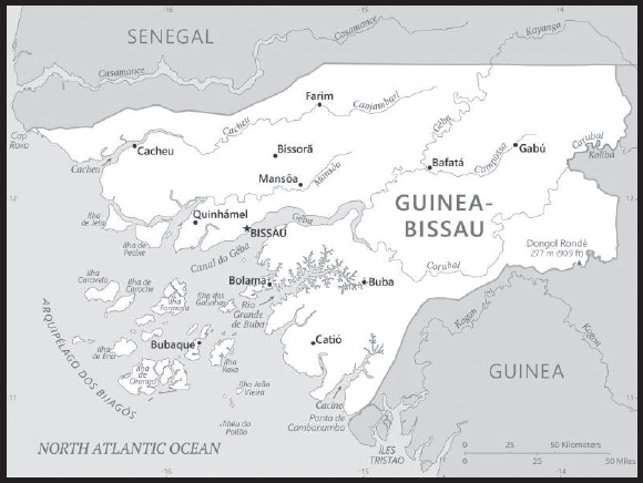
Location: Western Africa, bordering the North Atlantic Ocean, between Guinea and Senegal
Geographic coordinates: 12 00 N, 15 00 W
Map references: Africa
Area: total: 36,125 sq km
land: 28,120 sq km
water: 8,005 sq km
comparison ranking: total 137
Area - comparative: slightly less than three times the size of Connecticut
Land boundaries: total: 762 km
border countries (2): Guinea 421 km; Senegal 341 km
Coastline: 350 km
Maritime claims: territorial sea: 12 nm
exclusive economic zone: 200 nm
Climate: tropical; generally hot and humid; monsoonal-type rainy season (June to November) with southwesterly winds; dry season (December to May) with northeasterly harmattan winds
Terrain: mostly low-lying coastal plain with a deeply indented estuarine coastline rising to savanna in east; numerous off-shore islands including the Arquipelago Dos Bijagos consisting of 18 main islands and many small islets
Elevation: highest point: Dongol Ronde 277 m
lowest point: Atlantic Ocean 0 m
mean elevation: 70 m
Natural resources: fish, timber, phosphates, bauxite, clay, granite, limestone, unexploited deposits of petroleum
Land use: agricultural land: 44.8% (2018 est.)
arable land: 8.2% (2018 est.)
permanent crops: 6.9% (2018 est.)
permanent pasture: 29.7% (2018 est.)
forest: 55.2% (2018 est.)
other: 0% (2018 est.)
Irrigated land: 250 sq km (2012)
Major aquifers: Senegalo-Mauritanian Basin
Population distribution: approximately one-fifth of the population lives in the capital city of Bissau along the Atlantic coast; the remainder is distributed among the eight other, mainly rural, regions as shown in this population distribution map
Natural hazards: hot, dry, dusty harmattan haze may reduce visibility during dry season; brush fires
Geography - note: this small country is swampy along its western coast and low-lying inland
PEOPLE AND SOCIETY
Population: 2,078,820 (2023 est.)
comparison ranking: 151
Nationality: noun: Bissau-Guinean(s)
adjective: Bissau-Guinean
Ethnic groups: Balanta 30%, Fulani 30%, Manjaco 14%, Mandinga 13%, Papel 7%, unspecified smaller ethnic groups 6% (2015 est.)
Languages: Portuguese-based Creole, Portuguese (official; largely used as a second or third language), Pular (a Fula language), Mandingo
Religions: Muslim 46.1%, folk religions 30.6%, Christian 18.9%, other or unaffiliated 4.4% (2020 est.)
Demographic profile: Guinea-Bissau’s young and growing population is sustained by high fertility; approximately 60% of the population is under the age of 25 as of 2020. Its large reproductive-age population and total fertility rate of more than 4 children per woman offsets the country’s high infant and maternal mortality rates. The latter is among the world’s highest because of the prevalence of early childbearing, a lack of birth spacing, the high percentage of births outside of health care facilities, and a shortage of medicines and supplies.
Guinea-Bissau’s history of political instability, a civil war, and several coups (the latest in 2012) have resulted in a fragile state with a weak economy, high unemployment, rampant corruption, widespread poverty, and thriving drug and child trafficking. With the country lacking educational infrastructure, school funding and materials, and qualified teachers, and with the cultural emphasis placed on religious education, parents frequently send boys to study in residential Koranic schools (daaras) in Senegal and The Gambia. They often are extremely deprived and are forced into street begging or agricultural work by marabouts (Muslim religious teachers), who enrich themselves at the expense of the children. Boys who leave their marabouts often end up on the streets of Dakar or other large Senegalese towns and are vulnerable to even worse abuse.
Some young men lacking in education and job prospects become involved in the flourishing international drug trade. Local drug use and associated violent crime are growing.
Age structure: 0-14 years: 42.51% (male 444,214/female 439,517)
15-64 years: 54.38% (male 545,116/female 585,284)
65 years and over: 3.11% (2023 est.) (male 26,890/female 37,799)
Dependency ratios: total dependency ratio: 76.6
youth dependency ratio: 71.6
elderly dependency ratio: 5
potential support ratio: 20.1 (2021 est.)
Median age: total: 18 years (2020)
male: 17.4 years
female: 18.6 years
comparison ranking: total 214
Population growth rate: 2.54% (2023 est.)
comparison ranking: 19
Birth rate: 36.25 births/1,000 population (2023 est.)
comparison ranking: 12
Death rate: 7.32 deaths/1,000 population (2023 est.)
comparison ranking: 109
Net migration rate: -3.54 migrant(s)/1,000 population (2023 est.)
comparison ranking: 188
Population distribution: approximately one-fifth of the population lives in the capital city of Bissau along the Atlantic coast; the remainder is distributed among the eight other, mainly rural, regions as shown in this population distribution map
Urbanization: urban population: 45.5% of total population (2023)
rate of urbanization: 3.22% annual rate of change (2020-25 est.)
Major urban areas - population: 664,000 BISSAU (capital) (2023)
Sex ratio: at birth: 1.03 male(s)/female
0-14 years: 1.01 male(s)/female
15-64 years: 0.93 male(s)/female
65 years and over: 0.71 male(s)/female
total population: 0.96 male(s)/female (2023 est.)
Maternal mortality ratio: 725 deaths/100,000 live births (2020 est.)
comparison ranking: 5
Infant mortality rate: total: 47.69 deaths/1,000 live births (2023 est.)
male: 53.39 deaths/1,000 live births
female: 41.82 deaths/1,000 live births
comparison ranking: total 21
Life expectancy at birth: total population: 64.1 years (2023 est.)
male: 61.84 years
female: 66.42 years
comparison ranking: total population 206
Total fertility rate: 4.65 children born/woman (2023 est.)
comparison ranking: 14
Gross reproduction rate: 2.29 (2023 est.)
Contraceptive prevalence rate: 20.6% (2018/19)
Drinking water source: improved: urban: 90.6% of population
rural: 59.1% of population
total: 73.1% of population
unimproved: urban: 9.4% of population
rural: 40.9% of population
total: 26.9% of population (2020 est.)
Current health expenditure: 8.4% of GDP (2020)
Physicians density: 0.2 physicians/1,000 population (2020)
Sanitation facility access: improved: urban: 62.4% of population
rural: 7.6% of population
total: 31.8% of population
unimproved: urban: 37.6% of population
rural: 92.4% of population
total: 68.2% of population (2020 est.)
Major infectious diseases: degree of risk: very high (2023)
food or waterborne diseases: bacterial and protozoal diarrhea, hepatitis A, and typhoid fever
vectorborne diseases: malaria and dengue fever
water contact diseases: schistosomiasis
animal contact diseases: rabies
Obesity - adult prevalence rate: 9.5% (2016)
comparison ranking: 144
Alcohol consumption per capita: total: 3.21 liters of pure alcohol (2019 est.)
beer: 0.41 liters of pure alcohol (2019 est.)
wine: 0.98 liters of pure alcohol (2019 est.)
spirits: 0.54 liters of pure alcohol (2019 est.)
other alcohols: 1.28 liters of pure alcohol (2019 est.)
comparison ranking: total 108
Tobacco use: total: 9% (2020 est.)
male: 17% (2020 est.)
female: 0.9% (2020 est.)
comparison ranking: total 139
Children under the age of 5 years underweight: 18.8% (2019)
comparison ranking: 22
Currently married women (ages 15-49): 56.7% (2023 est.)
Child marriage: women married by age 15: 8.1%
women married by age 18: 25.7%
men married by age 18: 2.2% (2019 est.)
Education expenditures: 2.7% of GDP (2020 est.)
comparison ranking: 168
Literacy: definition: age 15 and over can read and write
total population: 52.9%
male: 67%
female: 39.9% (2021)
Youth unemployment rate (ages 15-24): total: 12.8% (2021 est.)
male: 11.6%
female: 14.2%
comparison ranking: total 135
ENVIRONMENT
Environment - current issues: deforestation (rampant felling of trees for timber and agricultural purposes); soil erosion; overgrazing; overfishing
Environment - international agreements: party to: Biodiversity, Climate Change, Climate Change-Kyoto Protocol, Climate Change-Paris Agreement, Comprehensive Nuclear Test Ban, Desertification, Endangered Species, Hazardous Wastes, Law of the Sea, Nuclear Test Ban, Ozone Layer Protection, Ship Pollution, Wetlands, Whaling
signed, but not ratified: none of the selected agreements
Climate: tropical; generally hot and humid; monsoonal-type rainy season (June to November) with southwesterly winds; dry season (December to May) with northeasterly harmattan winds
Land use: agricultural land: 44.8% (2018 est.)
arable land: 8.2% (2018 est.)
permanent crops: 6.9% (2018 est.)
permanent pasture: 29.7% (2018 est.)
forest: 55.2% (2018 est.)
other: 0% (2018 est.)
Urbanization: urban population: 45.5% of total population (2023)
rate of urbanization: 3.22% annual rate of change (2020-25 est.)
Revenue from forest resources: 9.24% of GDP (2018 est.)
comparison ranking: 4
Revenue from coal: 0% of GDP (2018 est.)
comparison ranking: 179
Air pollutants: particulate matter emissions: 34.85 micrograms per cubic meter (2019 est.)
carbon dioxide emissions: 0.29 megatons (2016 est.)
methane emissions: 1.46 megatons (2020 est.)
Waste and recycling: municipal solid waste generated annually: 289,514 tons (2015 est.)
Major aquifers: Senegalo-Mauritanian Basin
Total water withdrawal: municipal: 30 million cubic meters (2020 est.)
industrial: 10 million cubic meters (2020 est.)
agricultural: 140 million cubic meters (2020 est.)
Total renewable water resources: 31.4 billion cubic meters (2020 est.)
GOVERNMENT
Country name: conventional long form: Republic of Guinea-Bissau
conventional short form: Guinea-Bissau
local long form: Republica da Guine-Bissau
local short form: Guine-Bissau
former: Portuguese Guinea
etymology: the country is named after the Guinea region of West Africa that lies along the Gulf of Guinea and stretches north to the Sahel; “Bissau,” the name of the capital city, distinguishes the country from neighboring Guinea
Government type: semi-presidential republic
Capital: name: Bissau
geographic coordinates: 11 51 N, 15 35 W
time difference: UTC 0 (5 hours ahead of Washington, DC, during Standard Time)
etymology: the meaning of Bissau is uncertain, it might be an alternative name for the Papel people who live in the area of the city of Bissau
Administrative divisions: 9 regions (regioes, singular - regiao); Bafata, Biombo, Bissau, Bolama/Bijagos, Cacheu, Gabu, Oio, Quinara, Tombali
Independence: 24 September 1973 (declared); 10 September 1974 (from Portugal)
National holiday: Independence Day, 24 September (1973)
Constitution: history: promulgated 16 May 1984; note - constitution suspended following military coup April 2012, restored 2014; note - in May 2020, President EMBALO established a commission to draft a revised constitution
amendments: proposed by the National People’s Assembly if supported by at least one third of its members, by the Council of State (a presidential consultant body), or by the government; passage requires approval by at least two-thirds majority vote of the Assembly; constitutional articles on the republican and secular form of government and national sovereignty cannot be amended; amended 1991, 1993, 1996
Legal system: mixed legal system of civil law, which incorporated Portuguese law at independence and influenced by Economic Community of West African States (ECOWAS), West African Economic and Monetary Union (UEMOA), African Francophone Public Law, and customary law
International law organization participation: accepts compulsory ICJ jurisdiction; non-party state to the ICCt
Citizenship: citizenship by birth: yes
citizenship by descent only: yes
dual citizenship recognized: no
residency requirement for naturalization: 5 years
Suffrage: 18 years of age; universal
Executive branch: chief of state: President Umaro Sissoko EMBALO (since 27 February 2020); note - President EMBALO was declared winner of the 29 December 2019 runoff presidential election by the electoral commission, in late February 2020, EMBALO inaugurated himself with only military leadership present, even though the Supreme Court of Justice had yet to rule on an electoral litigation appeal lodged by his political rival Domingos Simoes PEREIRA
head of government: Prime Minister Nuno NABIAM (since 27 February 2020)
cabinet: Cabinet nominated by the prime minister, appointed by the president
elections/appointments: president directly elected by absolute majority popular vote in 2 rounds if needed for up to 2 consecutive 5-year terms; election last held on 24 November 2019 with a runoff on 29 December 2019 (next to be held in 2024); prime minister appointed by the president after consultation with party leaders in the National People’s Assembly; note - the president cannot apply for a third consecutive term
election results: Umaro Sissoco EMBALO elected president in second round; percent of vote in first round - Domingos Simoes PEREIRA (PAIGC) 40.1%, Umaro Sissoco EMBALO (Madem G15) 27.7%, Nuno Gomez NABIAM (APU-PDGB) 13.2%, Jose Mario VAZ (independent) 12.4%, other 6.6%; percent of vote in second round - Umaro Sissoco EMBALO 53.6%, Domingos Simoes PEREIRA 46.5% (2019)
Legislative branch: description: unicameral National People’s Assembly or Assembleia Nacional Popular (102 seats; 100 members directly elected in 27 multi-seat constituencies by closed party-list proportional representation vote and 2 elected in single-seat constituencies for citizens living abroad (Africa 1, Europe 1); all members serve 4-year terms)
elections: last election held 4 June 2023 (next election on 30 June 2027)
election results: percent of vote by party - PAIGC 39.4%, Madem G-15 21.1%, PRS 14.9%, other 12.5%; seats by party - PAIGC 54, Madem G-15 29, PRS- 12, other 7; composition - men 92, women 10, percent of women 9.8%
Judicial branch: highest court(s): Supreme Court or Supremo Tribunal de Justica (consists of 9 judges and organized into Civil, Criminal, and Social and Administrative Disputes Chambers); note - the Supreme Court has both appellate and constitutional jurisdiction
judge selection and term of office: judges nominated by the Higher Council of the Magistrate, a major government organ responsible for judge appointments, dismissals, and judiciary discipline; judges appointed by the president for life
subordinate courts: Appeals Court; regional (first instance) courts; military court
Political parties and leaders: African Party for the Independence of Guinea and Cabo Verde or PAIGC [Domingos SIMOES PEREIRA]
Democratic Convergence Party or PCD [Vicente FERNANDES]
Movement for Democratic Alternation Group of 15 or MADEM-G15 [Braima CAMARA]
National People’s Assembly – Democratic Party of Guinea Bissau or APU-PDGB [Nuno Gomes NABIAM]
New Democracy Party or PND [Mamadu Iaia DJALO]
Party for Social Renewal or PRS [Alberto NAMBEIA]
Republican Party for Independence and Development or PRID [Aristides GOMES]
Union for Change or UM [Agnelo REGALA]
International organization participation: ACP, AfDB, AOSIS, AU, CPLP, ECOWAS, FAO, FZ, G-77, IBRD, ICAO, ICRM, IDA, IDB, IFAD, IFC, IFRCS, ILO, IMF, IMO, Interpol, IOC, IOM, IPU, ITSO, ITU, ITUC (NGOs), MIGA, MINUSMA, NAM, OIC, OIF, OPCW, UN, UNCTAD, UNESCO, UNIDO, UNWTO, UPU, WADB (regional), WAEMU, WCO, WFTU (NGOs), WHO, WIPO, WMO, WTO
Diplomatic representation in the US: chief of mission: none; note - Guinea-Bissau does not have official representation in Washington, DC
Diplomatic representation from the US: chief of mission: Ambassador Mike RAYNOR (since 20 April 2022)
mailing address: 2080 Bissau Place, Washington DC 20521-2080
email address and website:
Flag description: two equal horizontal bands of yellow (top) and green with a vertical red band on the hoist side; there is a black five-pointed star centered in the red band; yellow symbolizes the sun; green denotes hope; red represents blood shed during the struggle for independence; the black star stands for African unity
note: uses the popular Pan-African colors of Ethiopia; the flag design was heavily influenced by the Ghanaian flag
National symbol(s): black star; national colors: red, yellow, green, black
National anthem: name: “Esta e a Nossa Patria Bem Amada” (This Is Our Beloved Country)
lyrics/music: Amilcar Lopes CABRAL/XIAO He
note: adopted 1974; a delegation from then Portuguese Guinea visited China in 1963 and heard music by XIAO He; Amilcar Lopes CABRAL, the leader of Guinea-Bissau’s independence movement, asked the composer to create a piece that would inspire his people to struggle for independence
ECONOMY
Economic overview: extremely poor West African economy; ethnically diverse labor force; increasing government expenditures; slight inflation due to food supply disruptions; major cashew exporter; systemic banking instabilities and corruption; vulnerable to oil price shocks
Real GDP (purchasing power parity): $3.774 billion (2021 est.)
$3.636 billion (2020 est.)
$3.725 billion (2019 est.)
note: data are in 2017 dollars
comparison ranking: 186
Real GDP growth rate: 3.8% (2021 est.)
-2.4% (2020 est.)
4.5% (2019 est.)
comparison ranking: 125
Real GDP per capita: $1,800 (2021 est.)
$1,800 (2020 est.)
$1,900 (2019 est.)
note: data are in 2017 dollars
comparison ranking: 214
GDP (official exchange rate): $1.339 billion (2019 est.)
Inflation rate (consumer prices): 2.24% (2021 est.)
1.14% (2020 est.)
0.25% (2019 est.)
comparison ranking: 148
GDP - composition, by sector of origin
agriculture: 50% (2017 est.)
industry: 13.1% (2017 est.)
services: 36.9% (2017 est.)
comparison rankings: services 217; industry 191; agriculture 4
GDP - composition, by end use: household consumption: 83.9% (2017 est.)
government consumption: 12% (2017 est.)
investment in fixed capital: 4.1% (2017 est.)
investment in inventories: 0.2% (2017 est.)
exports of goods and services: 26.4% (2017 est.)
imports of goods and services: -26.5% (2017 est.)
Agricultural products: rice, cashew nuts, roots/tubers nes, oil palm fruit, plantains, cassava, groundnuts, vegetables, coconuts, fruit
Industries: agricultural products processing, beer, soft drinks
Industrial production growth rate: -0.7% (2020 est.)
comparison ranking: 166
Labor force: 867,500 (2021 est.)
comparison ranking: 149
Labor force - by occupation: agriculture: 82%
industry and services: 18% (2000 est.)
Unemployment rate: 6.76% (2021 est.)
6.74% (2020 est.)
6.04% (2019 est.)
comparison ranking: 115
Youth unemployment rate (ages 15-24): total: 12.8% (2021 est.)
male: 11.6%
female: 14.2%
comparison ranking: total 135
Population below poverty line: 67% (2015 est.)
Gini Index coefficient - distribution of family income: 34.8 (2018 est.)
comparison ranking: 106
Household income or consumption by percentage share: lowest 10%: 2.9%
highest 10%: 28% (2002)
Budget: revenues: $222 million (2019 est.)
expenditures: $278 million (2019 est.)
Budget surplus (+) or deficit (-): -1.3% (of GDP) (2017 est.)
comparison ranking: 87
Public debt: 53.9% of GDP (2017 est.)
57.9% of GDP (2016 est.)
comparison ranking: 93
Taxes and other revenues: 9.46% (of GDP) (2019 est.)
comparison ranking: 197
Fiscal year: calendar year
Current account balance: -$38.683 million (2020 est.)
-$127.41 million (2019 est.)
-$54.134 million (2018 est.)
comparison ranking: 86
Exports: $232.536 million (2020 est.) note: data are in current year dollars
$291.805 million (2019 est.) note: data are in current year dollars
$380.428 million (2018 est.)
comparison ranking: 199
Exports - partners: India 50%, Belgium 28%, Cote d’Ivoire 8% (2019)
Exports - commodities: cashews, natural gas, mackerel, fish, scrap vessels (2021)
Imports: $439 million (2020 est.) note: data are in current year dollars
$502 million (2019 est.) note: data are in current year dollars
$459 million (2018 est.)
comparison ranking: 202
Imports - partners: Portugal 31%, Senegal 20%, China 10%, Netherlands 7%, Pakistan 7% (2019)
Imports - commodities: refined petroleum, rice, wheat products, soups/broths, malt extract (2019)
Reserves of foreign exchange and gold: $356.4 million (31 December 2017 est.)
$349.4 million (31 December 2016 est.)
comparison ranking: 173
Debt - external: $1.095 billion (31 December 2010 est.)
$941.5 million (31 December 2000 est.)
comparison ranking: 164
Exchange rates: Communaute Financiere Africaine francs (XOF) per US dollar -
Exchange rates: 554.531 (2021 est.)
575.586 (2020 est.)
585.911 (2019 est.)
555.446 (2018 est.)
580.657 (2017 est.)
ENERGY
Electricity access: population without electricity: 1 million (2020)
electrification - total population: 35.7% (2021)
electrification - urban areas: 60.5% (2021)
electrification - rural areas: 15.8% (2021)
Electricity: installed generating capacity: 28,000 kW (2020 est.)
consumption: 76.458 million kWh (2019 est.)
exports: 0 kWh (2019 est.)
imports: 0 kWh (2019 est.)
transmission/distribution losses: 6 million kWh (2019 est.)
comparison rankings: installed generating capacity 202; transmission/distribution losses 200; imports 183; exports 176; consumption 199
Electricity generation sources: fossil fuels: 97.6% of total installed capacity (2020 est.)
solar: 2.4% of total installed capacity (2020 est.)
Petroleum: total petroleum production: 0 bbl/day (2021 est.)
refined petroleum consumption: 2,200 bbl/day (2019 est.)
Refined petroleum products - imports: 2,625 bbl/day (2015 est.)
comparison ranking: 186
Carbon dioxide emissions: 342,000 metric tonnes of CO2 (2019 est.)
from petroleum and other liquids: 342,000 metric tonnes of CO2 (2019 est.)
comparison ranking: total emissions 193
Energy consumption per capita: 2.46 million Btu/person (2019 est.)
comparison ranking: 184
COMMUNICATIONS
Telephones - fixed lines: total subscriptions: 4,800 (2009 est.)
subscriptions per 100 inhabitants: (2009 est.) less than 1
comparison ranking: total subscriptions 206
Telephones - mobile cellular: total subscriptions: 2,236,511 (2021 est.)
subscriptions per 100 inhabitants: 109 (2021 est.)
comparison ranking: total subscriptions 147
Telecommunication systems: general assessment: small system including a combination of microwave radio relay, open-wire lines, radiotelephone, and mobile cellular communications; 2 mobile network operators; one of the poorest countries in the world and this is reflected in the country’s telecommunications development; radio is the most important source of information for the public (2020)
domestic: fixed-line teledensity less than 1 per 100 persons; mobile cellular teledensity is just over 109 per 100 persons (2021)
international: country code - 245; ACE submarine cable connecting Guinea-Bissau with 20 landing points in Western and South Africa and Europe (2019)
Broadcast media: 1 state-owned TV station, Televisao da Guine-Bissau (TGB) and a second station, Radio e Televisao de Portugal (RTP) Africa, is operated by Portuguese public broadcaster (RTP); 1 state-owned radio station, several private radio stations, and some community radio stations; multiple international broadcasters are available (2019)
Internet country code: .gw
Internet users: total: 735,000 (2021 est.)
percent of population: 35% (2021 est.)
comparison ranking: total 159
Broadband - fixed subscriptions: total: 2,383 (2020 est.)
subscriptions per 100 inhabitants: 0.1 (2020 est.)
comparison ranking: total 198
TRANSPORTATION
Civil aircraft registration country code prefix: J5
Airports: 8 (2021)
comparison ranking: total 161
Airports - with paved runways: 2
note: paved runways have a concrete or asphalt surface but not all have facilities for refueling, maintenance, or air traffic control; the length of a runway required for aircraft to safely operate depends on a number of factors including the type of aircraft, the takeoff weight (including passengers, cargo, and fuel), engine types, flap settings, landing speed, elevation of the airport, and average maximum daily air temperature; paved runways can reach a length of 5,000 m (16,000 ft.), but the “typical” length of a commercial airline runway is between 2,500-4,000 m (8,000-13,000 ft.)
Airports - with unpaved runways: 6
note: unpaved runways have a surface composition such as grass or packed earth and are most suited to the operation of light aircraft; unpaved runways are usually short, often less than 1,000 m (3,280 ft.) in length; airports with unpaved runways often lack facilities for refueling, maintenance, or air traffic control
Roadways: total: 4,400 km (2018)
paved: 453 km (2018)
unpaved: 3,947 km (2018)
comparison ranking: total 150
Waterways: 1,367 km (2022) major rivers Geba- 550km, Corubal 560 km, Cacheu 257 km (rivers are partially navigable; many inlets and creeks provide shallow-water access to much of interior)
comparison ranking: 56
Merchant marine: total: 8 (2022)
by type: general cargo 5, other 3
comparison ranking: total 162
Ports and terminals: major seaport(s): Bissau, Buba, Cacheu, Farim
MILITARY AND SECURITY
Military and security forces: People’s Revolutionary Armed Force (FARP): Army, Navy, Air Force
Ministry of Internal Administration: Guard Nacional (a gendarmerie force), Public Order Police, Border Police, Rapid Intervention Police, Maritime Police (2023)
note: the Public Order Police is responsible for maintaining law and order, while the Judicial Police, under the Ministry of Justice, has primary responsibility for investigating drug trafficking, terrorism, and other transnational crimes
Military expenditures: 1.6% of GDP (2022 est.)
1.8% of GDP (2021 est.)
1.7% of GDP (2020 est.)
1.9% of GDP (2019 est.)
1.7% of GDP (2018 est.)
comparison ranking: 83
Military and security service personnel strengths: approximately 4,000 active troops, including a few hundred air and naval personnel (2023)
Military equipment inventories and acquisitions: the FARP is armed mostly with Soviet-era equipment, much of which is reportedly unserviceable (2023)
Military service age and obligation: 18-25 years of age for selective compulsory military service for men and women (Air Force service is voluntary); 16 years of age or younger, with parental consent, for voluntary service (2023)
Military - note: the FARP is focused on external security, but also has some internal security duties, and it has been influential in the country’s politics since independence was gained in 1974, having staged at least nine coups as well as several mutinies; FARP members were suspected of coup plotting as recently as 2021, and the military has been accused of involvement in narcotics trafficking; since the 2000s, the FARP has undergone various attempts at defense and security sector reforms with limited success under the auspices of the African Union, the EU, the Economic Community of West Africa (ECOWAS), and the UN
from 2012-2020, ECOWAS deployed a security force to Guinea-Bissau to manage the post-coup transition, including protecting key political figures and public buildings, restoring civil institutions, and re-establishing the rule of law; at the height of the deployment, the force, known as the ECOWAS Mission in Guinea-Bissau (ECOMIB), deployed nearly 700 military and police personnel from Burkina Faso, Nigeria, and Senegal (2023)
TRANSNATIONAL ISSUES
Disputes - international: Guinea-Bissau - Senegal: there are no border disputes and the frontier is relatively stable although some rebels conducting a longstanding low-grade insurgency in the southern Casamance region of Senegal have used Guinea-Bissau as a safe haven
Refugees and internally displaced persons: refugees (country of origin): 7,757 (Senegal) (2022)
Trafficking in persons: tier rating: Tier 3 — Guinea-Bissau does not fully meet the minimum standards for the elimination of trafficking and is not making significant efforts to do so, therefore Guinea-Bissau remained on Tier 3; despite the lack of efforts, the government took some steps to address trafficking, including investigating cases, identifying potential victims, launching a national referral mechanism, and convening its anti-trafficking committee; however, Guinea-Bissau has never convicted a trafficker and failed to prosecute alleged traffickers for the third consecutive year; the government continued to lack adequate victim identification and services, and has lacked sufficient resources and political will to comprehensively combat trafficking (2022)
trafficking profile: human traffickers exploit domestic and foreign victims in Guinea-Bissau and Bissau-Guineans abroad; forced child begging is the most prevalent form of trafficking; boys reportedly were transported to southern Senegal for forced manual and agricultural labor; girls may be subjected to forced domestic service and child prostitution in Guinea, Senegal and the Gambia; women are recruited and exploited in domestic servitude abroad; girls, and to a lesser extent boys, are exploited in child sex tourism in the Bijagos, an archipelago off the coast of Guinea-Bissau that is largely devoid of government and law enforcement presence; Cuban nationals in Guinea-Bissau may have been forced to work by the Cuban government (2022)
Illicit drugs: important transit country for South American cocaine en route to Europe; enabling environment for trafficker operations due to pervasive corruption; archipelago-like geography near the capital facilitates drug smuggling
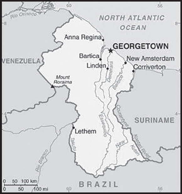
INTRODUCTION
Background: Originally a Dutch colony in the 17th century, by 1815 Guyana had become a British possession. The abolition of slavery led to settlement of urban areas by former slaves and the importation of indentured servants from India to work the sugar plantations. The resulting ethnocultural divide has persisted and has led to turbulent politics. Guyana achieved independence from the UK in 1966, and since then it has been ruled mostly by socialist-oriented governments. In 1992, Cheddi JAGAN was elected president in what is considered the country’s first free and fair election since independence. After his death five years later, his wife, Janet JAGAN, became president but resigned in 1999 due to poor health. Her successor, Bharrat JAGDEO, was elected in 2001 and again in 2006. Early elections held in May 2015 resulted in the first change in governing party and the replacement of President Donald RAMOTAR by current President David GRANGER. After a December 2018 no-confidence vote against the GRANGER government, national elections were constitutionally required to take place within three months. After over a year of extra-constitutional rule by the GRANGER administration, elections were held, though voting irregularities led to a nationwide recount. The current Irfaan ALI administration was sworn in to office in August 2020. The discovery of oil in 2015 has been the primary economic and political focus, with many hoping the significant reserves will transform one of the poorest countries in the region. Guyana is the only English-speaking country in South America and shares cultural and historical bonds with the Anglophone Caribbean.
GEOGRAPHY
Location: Northern South America, bordering the North Atlantic Ocean, between Suriname and Venezuela
Geographic coordinates: 5 00 N, 59 00 W
Map references: South America
Area: total: 214,969 sq km
land: 196,849 sq km
water: 18,120 sq km
comparison ranking: total 85
Area - comparative: slightly smaller than Idaho; almost twice the size of Tennessee
Land boundaries: total: 2,933 km
border countries (3): Brazil 1,308 km; Suriname 836 km; Venezuela 789 km
Coastline: 459 km
Maritime claims: territorial sea: 12 nm
exclusive economic zone: 200 nm
continental shelf: 200 nm or to the outer edge of the continental margin
Climate: tropical; hot, humid, moderated by northeast trade winds; two rainy seasons (May to August, November to January)
Terrain: mostly rolling highlands; low coastal plain; savanna in south
Elevation: highest point: Laberintos del Norte on Mount Roraima 2,775 m
lowest point: Atlantic Ocean 0 m
mean elevation: 207 m
Natural resources: bauxite, gold, diamonds, hardwood timber, shrimp, fish
Land use: agricultural land: 8.4% (2018 est.)
arable land: 2.1% (2018 est.)
permanent crops: 0.1% (2018 est.)
permanent pasture: 6.2% (2018 est.)
forest: 77.4% (2018 est.)
other: 14.2% (2018 est.)
Irrigated land: 1,430 sq km (2012)
Major watersheds (area sq km): Atlantic Ocean drainage: Amazon (6,145,186 sq km), Orinoco (953,675 sq km)
Population distribution: population is heavily concentrated in the northeast in and around Georgetown, with noteable concentrations along the Berbice River to the east; the remainder of the country is sparsely populated
Natural hazards: flash flood threat during rainy seasons
Geography - note: the third-smallest country in South America after Suriname and Uruguay; substantial portions of its western and eastern territories are claimed by Venezuela and Suriname respectively; contains some of the largest unspoiled rainforests on the continent
PEOPLE AND SOCIETY
Population: 791,739 (2023 est.)
comparison ranking: 166
Nationality: noun: Guyanese (singular and plural)
adjective: Guyanese
Ethnic groups: East Indian 39.8%, African descent 29.3%, mixed 19.9%, Amerindian 10.5%, other 0.5% (includes Portuguese, Chinese, White) (2012 est.)
Languages: English (official), Guyanese Creole, Amerindian languages (including Caribbean and Arawak languages), Indian languages (including Caribbean Hindustani, a dialect of Hindi), Chinese (2014 est.)
Religions: Protestant 34.8% (Pentecostal 22.8%, Seventh Day Adventist 5.4%, Anglican 5.2%, Methodist 1.4%), Hindu 24.8%, other Christian 20.8%, Roman Catholic 7.1%, Muslim 6.8%, Jehovah’s Witness 1.3%, Rastafarian 0.5%, other 0.9%, none 3.1% (2012 est.)
Demographic profile: Guyana is the only English-speaking country in South America and shares cultural and historical bonds with the Anglophone Caribbean. Guyana’s two largest ethnic groups are the Afro-Guyanese (descendants of African slaves) and the Indo-Guyanese (descendants of Indian indentured laborers), which together comprise about three quarters of Guyana’s population. Tensions periodically have boiled over between the two groups, which back ethnically based political parties and vote along ethnic lines. Poverty reduction has stagnated since the late 1990s. About one-third of the Guyanese population lives below the poverty line; indigenous people are disproportionately affected. Although Guyana’s literacy rate is reported to be among the highest in the Western Hemisphere, the level of functional literacy is considerably lower, which has been attributed to poor education quality, teacher training, and infrastructure.
Guyana’s emigration rate is among the highest in the world - more than 55% of its citizens reside abroad - and it is one of the largest recipients of remittances relative to GDP among Latin American and Caribbean counties. Although remittances are a vital source of income for most citizens, the pervasive emigration of skilled workers deprives Guyana of professionals in healthcare and other key sectors. More than 80% of Guyanese nationals with tertiary level educations have emigrated. Brain drain and the concentration of limited medical resources in Georgetown hamper Guyana’s ability to meet the health needs of its predominantly rural population. Guyana has one of the highest HIV prevalence rates in the region and continues to rely on international support for its HIV treatment and prevention programs.
Age structure: 0-14 years: 23.65% (male 95,605/female 91,654)
15-64 years: 68.49% (male 281,157/female 261,113)
65 years and over: 7.86% (2023 est.) (male 27,269/female 34,941)
Dependency ratios: total dependency ratio: 53.6
youth dependency ratio: 44.1
elderly dependency ratio: 9.5
potential support ratio: 10.6 (2021 est.)
Median age: total: 27.5 years (2020)
male: 27.2 years
female: 27.9 years
comparison ranking: total 146
Population growth rate: 0.28% (2023 est.)
comparison ranking: 169
Birth rate: 16.74 births/1,000 population (2023 est.)
comparison ranking: 93
Death rate: 6.95 deaths/1,000 population (2023 est.)
comparison ranking: 119
Net migration rate: -6.99 migrant(s)/1,000 population (2023 est.)
comparison ranking: 214
Population distribution: population is heavily concentrated in the northeast in and around Georgetown, with noteable concentrations along the Berbice River to the east; the remainder of the country is sparsely populated
Urbanization: urban population: 27.2% of total population (2023)
rate of urbanization: 1.01% annual rate of change (2020-25 est.)
Major urban areas - population: 110,000 GEORGETOWN (capital) (2018)
Sex ratio: at birth: 1.05 male(s)/female
0-14 years: 1.04 male(s)/female
15-64 years: 1.08 male(s)/female
65 years and over: 0.78 male(s)/female
total population: 1.04 male(s)/female (2023 est.)
Mother’s mean age at first birth: 20.8 years (2009 est.)
note: data represents median age at first birth among women 25-29
Maternal mortality ratio: 112 deaths/100,000 live births (2020 est.)
comparison ranking: 65
Infant mortality rate: total: 21.63 deaths/1,000 live births (2023 est.)
male: 24.45 deaths/1,000 live births
female: 18.67 deaths/1,000 live births
comparison ranking: total 75
Life expectancy at birth: total population: 72.15 years (2023 est.)
male: 70.32 years
female: 74.07 years
comparison ranking: total population 162
Total fertility rate: 2.06 children born/woman (2023 est.)
comparison ranking: 96
Gross reproduction rate: 1 (2023 est.)
Contraceptive prevalence rate: 29.9% (2019/20)
Drinking water source: improved: urban: 100% of population
rural: 95.6% of population
total: 96.8% of population
unimproved: urban: 0% of population
rural: 4.4% of population
total: 3.2% of population (2020 est.)
Current health expenditure: 5.5% of GDP (2020)
Physicians density: 1.42 physicians/1,000 population (2020)
Hospital bed density: 1.7 beds/1,000 population (2016)
Sanitation facility access: improved: urban: 97.8% of population
rural: 95.4% of population
total: 96% of population
unimproved: urban: 2.2% of population
rural: 4.6% of population
total: 4% of population (2020 est.)
Major infectious diseases: degree of risk: very high (2023)
food or waterborne diseases: bacterial and protozoal diarrhea, hepatitis A, and typhoid fever
vectorborne diseases: dengue fever and malaria
Obesity - adult prevalence rate: 20.2% (2016)
comparison ranking: 102
Alcohol consumption per capita: total: 5.11 liters of pure alcohol (2019 est.)
beer: 2.75 liters of pure alcohol (2019 est.)
wine: 0.04 liters of pure alcohol (2019 est.)
spirits: 2.3 liters of pure alcohol (2019 est.)
other alcohols: 0.02 liters of pure alcohol (2019 est.)
comparison ranking: total 83
Tobacco use: total: 12.1% (2020 est.)
male: 21.7% (2020 est.)
female: 2.4% (2020 est.)
comparison ranking: total 121
Children under the age of 5 years underweight: 9.4% (2019)
comparison ranking: 59
Currently married women (ages 15-49): 62.6% (2023 est.)
Education expenditures: 4.5% of GDP (2018 est.)
comparison ranking: 98
Literacy: definition: age 15 and over has ever attended school
total population: 88.8%
male: 89.3%
female: 88.4% (2021)
School life expectancy (primary to tertiary education): total: 11 years
male: 11 years
female: 12 years (2012)
Youth unemployment rate (ages 15-24): total: 29.9% (2021 est.)
male: 23.5%
female: 39.6%
comparison ranking: total 40
ENVIRONMENT
Environment - current issues: water pollution from sewage and agricultural and industrial chemicals; deforestation
Environment - international agreements: party to: Biodiversity, Climate Change, Climate Change-Kyoto Protocol, Climate Change-Paris Agreement, Comprehensive Nuclear Test Ban, Desertification, Endangered Species, Hazardous Wastes, Law of the Sea, Marine Dumping-London Protocol, Ozone Layer Protection, Ship Pollution, Tropical Timber 2006
signed, but not ratified: none of the selected agreements
Climate: tropical; hot, humid, moderated by northeast trade winds; two rainy seasons (May to August, November to January)
Land use: agricultural land: 8.4% (2018 est.)
arable land: 2.1% (2018 est.)
permanent crops: 0.1% (2018 est.)
permanent pasture: 6.2% (2018 est.)
forest: 77.4% (2018 est.)
other: 14.2% (2018 est.)
Urbanization: urban population: 27.2% of total population (2023)
rate of urbanization: 1.01% annual rate of change (2020-25 est.)
Revenue from forest resources: 4.56% of GDP (2018 est.)
comparison ranking: 13
Revenue from coal: 0% of GDP (2018 est.)
comparison ranking: 175
Air pollutants: particulate matter emissions: 11.11 micrograms per cubic meter (2019 est.)
carbon dioxide emissions: 2.38 megatons (2016 est.)
methane emissions: 1.81 megatons (2020 est.)
Waste and recycling: municipal solid waste generated annually: 179,252 tons (2010 est.)
municipal solid waste recycled annually: 968 tons (2010 est.)
percent of municipal solid waste recycled: 0.5% (2010 est.)
Major watersheds (area sq km): Atlantic Ocean drainage: Amazon (6,145,186 sq km), Orinoco (953,675 sq km)
Total water withdrawal: municipal: 60 million cubic meters (2020 est.)
industrial: 20 million cubic meters (2020 est.)
agricultural: 1.36 billion cubic meters (2020 est.)
Total renewable water resources: 271 billion cubic meters (2020 est.)
GOVERNMENT
Country name: conventional long form: Cooperative Republic of Guyana
conventional short form: Guyana
former: British Guiana
etymology: the name is derived from Guiana, the original name for the region that included British Guiana, Dutch Guiana, and French Guiana; ultimately the word is derived from an indigenous Amerindian language and means “Land of Many Waters” (referring to the area’s multitude of rivers and streams)
Government type: parliamentary republic
Capital: name: Georgetown
geographic coordinates: 6 48 N, 58 09 W
time difference: UTC-4 (1 hour ahead of Washington, DC, during Standard Time)
etymology: when the British took possession of the town from the Dutch in 1812, they renamed it Georgetown in honor of King GEORGE III (1738-1820)
Administrative divisions: 10 regions; Barima-Waini, Cuyuni-Mazaruni, Demerara-Mahaica, East Berbice-Corentyne, Essequibo Islands-West Demerara, Mahaica-Berbice, Pomeroon-Supenaam, Potaro-Siparuni, Upper Demerara-Berbice, Upper Takutu-Upper Essequibo
Independence: 26 May 1966 (from the UK)
National holiday: Republic Day, 23 February (1970)
Constitution: history: several previous; latest promulgated 6 October 1980
amendments: proposed by the National Assembly; passage of amendments affecting constitutional articles, such as national sovereignty, government structure and powers, and constitutional amendment procedures, requires approval by the Assembly membership, approval in a referendum, and assent of the president; other amendments only require Assembly approval; amended many times, last in 2016
Legal system: common law system, based on the English model, with some Roman-Dutch civil law influence
International law organization participation: has not submitted an ICJ jurisdiction declaration; accepts ICCt jurisdiction
Citizenship: citizenship by birth: yes
citizenship by descent only: yes
dual citizenship recognized: no
residency requirement for naturalization: na
Suffrage: 18 years of age; universal
Executive branch: chief of state: President Mohammed Irfaan ALI (since 2 August 2020); First Vice President Mark PHILLIPS (since 2 August 2020); Vice President Bharrat JAGDEO (since 2 August 2020); Prime Minister Mark PHILLIPS (since 2 August 2020); note - the president is both chief of state and head of government
head of government: President Mohammed Irfaan ALI (since 2 August 2020); First Vice President Mark PHILLIPS (since 2 August 2020); Vice President Bharrat JAGDEO (since 2 August 2020)
cabinet: Cabinet of Ministers appointed by the president, responsible to the National Assembly
elections/appointments: the predesignated candidate of the winning party in the last National Assembly election becomes president for a 5-year term (no term limits); election last held on 2 March 2020 (next to be held in 2025); prime minister appointed by the president
election results:
2020: Mohammed Irfaan ALI (PPP/C) designated president by the majority party in the National Assembly
2015: David GRANGER (APNU-AFC) designated president by the majority party in the National Assembly
Legislative branch: description: unicameral National Assembly (70 seats; 40 members directly elected in a single nationwide constituencies, 25 directly elected in multi-seat constituencies - all by closed-list proportional representation vote, 2 non-elected ministers, 2 non-elected parliamentary secretaries, and the speaker; members serve 5-year terms)
elections: last held on 2 March 2020 (next to be held in 2025)
election results: percent of vote by party - PPP/C 50.69%, APNU-AFC 47.34%, LJP 0.58%, ANUG 0.5%, TNM 0.05%, other 0.84%; seats by party - PPP/C 33, APNU-AFC 31, LJP-ANUG-TNM 1; composition (elected and non-elected) - men 45, women 25, percent of women 35.7%; note - the initial results were declared invalid and a partial recount was conducted from 6 May to 8 June 2020, in which PPP/C was declared the winner
Judicial branch: highest court(s): Supreme Court of Judicature (consists of the Court of Appeal with a chief justice and 3 justices, and the High Court with a chief justice and 10 justices organized into 3- or 5-judge panels); note - in 2009, Guyana acceded to the Caribbean Court of Justice as the final court of appeal in civil and criminal cases, replacing that of the Judicial Committee of the Privy Council (in London)
judge selection and term of office: Court of Appeal and High Court chief justices appointed by the president; other judges of both courts appointed by the Judicial Service Commission, a body appointed by the president; judges appointed for life with retirement at age 65
subordinate courts: Land Court; magistrates’ courts
Political parties and leaders: A New and United Guyana or ANUG [Ralph RAMKARRAN]
A Partnership for National Unity or APNU [Joseph HARMON]
Alliance for Change or AFC [Khemraj RAMJATTAN]
Justice for All Party [Chandra Narine SHARMA]
Liberty and Justice Party or LJP [Lenox SHUMAN]
National Independent Party or NIP [Saphier Husain SUBEDAR]
People’s Progressive Party/Civic or PPP/C [Dr. Bharrat JAGDEO]
The New Movement or TNM [Dr. Asha KISSOON]
The United Force or TUF [Marissa NADIR]
United Republican Party or URP [Vishnu BANDHU]
International organization participation: ACP, AOSIS, C, Caricom, CD, CDB, CELAC, FAO, G-77, IADB, IBRD, ICAO, ICCt, ICRM, IDA, IFAD, IFC, IFRCS, ILO, IMF, IMO, Interpol, IOC, IOM, ISO (correspondent), ITU, LAES, MIGA, NAM, OAS, OIC, OPANAL, OPCW, PCA, Petrocaribe, PROSUR, UN, UNASUR, UNCTAD, UNESCO, UNIDO, UPU, WCO, WFTU (NGOs), WHO, WIPO, WMO, WTO
Diplomatic representation in the US: chief of mission: Ambassador Samuel Archibald HINDS (since 7 July 2021)
chancery: 2490 Tracy Place NW, Washington, DC 20008
telephone: [1] (202) 265-6900
FAX: [1] (202) 232-1297
email address and website:
consulate(s) general: New York
Diplomatic representation from the US: chief of mission: Ambassador Sarah-Ann LYNCH (since 13 March 2019)
embassy: 100 Young and Duke Streets, Kingston, Georgetown
mailing address: 3170 Georgetown Place, Washington DC 20521-3170
telephone: [592] 225-4900 through 4909
FAX: [592] 225-8497
email address and website:
Flag description: green with a red isosceles triangle (based on the hoist side) superimposed on a long, yellow arrowhead; there is a narrow, black border between the red and yellow, and a narrow, white border between the yellow and the green; green represents forest and foliage; yellow stands for mineral resources and a bright future; white symbolizes Guyana’s rivers; red signifies zeal and the sacrifice of the people; black indicates perseverance; also referred to by its nickname The Golden Arrowhead
National symbol(s): Canje pheasant (hoatzin), jaguar, Victoria Regia water lily; national colors: red, yellow, green, black, white
National anthem: name: “Dear Land of Guyana, of Rivers and Plains”
lyrics/music: Archibald Leonard LUKERL/Robert Cyril Gladstone POTTER
note: adopted 1966
ECONOMY
Economic overview: small, hydrocarbon-driven South American export economy; major forest coverage being leveraged in carbon credit offsets to encourage preservation; strengthening financial sector; large bauxite and gold resources
Real GDP (purchasing power parity): $17.64 billion (2021 est.)
$14.693 billion (2020 est.)
$10.24 billion (2019 est.)
note: data are in 2017 dollars
comparison ranking: 157
Real GDP growth rate: 20.06% (2021 est.)
43.48% (2020 est.)
5.35% (2019 est.)
comparison ranking: 5
Real GDP per capita: $21,900 (2021 est.)
$18,400 (2020 est.)
$12,800 (2019 est.)
note: data are in 2017 dollars
comparison ranking: 85
GDP (official exchange rate): $3.561 billion (2017 est.)
Inflation rate (consumer prices): 5.03% (2021 est.)
0.99% (2020 est.)
2.09% (2019 est.)
comparison ranking: 68
GDP - composition, by sector of origin: agriculture: 15.4% (2017 est.)
industry: 15.3% (2017 est.)
services: 69.3% (2017 est.)
comparison rankings: services 74; industry 180; agriculture 64
GDP - composition, by end use: household consumption: 71.1% (2017 est.)
government consumption: 18.2% (2017 est.)
investment in fixed capital: 25.4% (2017 est.)
investment in inventories: 0% (2017 est.)
exports of goods and services: 47.8% (2017 est.)
imports of goods and services: -63% (2017 est.)
Agricultural products: rice, sugar cane, coconuts, pumpkins, squash, gourds, milk, eggplants, green chillies/peppers, poultry
Industries: bauxite, sugar, rice milling, timber, textiles, gold mining
Industrial production growth rate: 33.52% (2021 est.)
comparison ranking: 2
Labor force: 299,300 (2021 est.)
comparison ranking: 167
Unemployment rate: 16.42% (2021 est.)
16.43% (2020 est.)
13.99% (2019 est.)
comparison ranking: 29
Youth unemployment rate (ages 15-24): total: 29.9% (2021 est.)
male: 23.5%
female: 39.6%
comparison ranking: total 40
Population below poverty line: 35% (2006 est.)
Gini Index coefficient - distribution of family income: 44.6 (2007 est.)
comparison ranking: 29
Household income or consumption by percentage share: lowest 10%: 1.3%
highest 10%: 33.8% (1999)
Budget: revenues: $1.333 billion (2019 est.)
expenditures: $1.467 billion (2019 est.)
Budget surplus (+) or deficit (-): -4.5% (of GDP) (2017 est.)
comparison ranking: 163
Public debt: 52.2% of GDP (2017 est.)
50.7% of GDP (2016 est.)
comparison ranking: 100
Taxes and other revenues: 28.1% (of GDP) (2017 est.)
comparison ranking: 34
Fiscal year: calendar year
Current account balance: -$2.087 billion (2021 est.)
-$396.533 million (2020 est.)
-$2.717 billion (2019 est.)
comparison ranking: 158
Exports: $4.64 billion (2021 est.) note: data are in current year dollars
$2.799 billion (2020 est.) note: data are in current year dollars
$1.805 billion (2019 est.)
comparison ranking: 133
Exports - partners: United States 40%, Singapore 14%, United Arab Emirates 6%, United Kingdom 6%, Barbados 6% (2021)
Exports - commodities: crude petroleum, gold, rice, aluminum ores, railway shipping containers, rums (2021)
Imports: $6.611 billion (2021 est.) note: data are in current year dollars
$3.756 billion (2020 est.) note: data are in current year dollars
$5.025 billion (2019 est.)
comparison ranking: 129
Imports - partners: Singapore 33%, United States 19%, Trinidad and Tobago 12%, China 8%, Brazil 2% (2021)
Imports - commodities: floating drilling platforms, refined petroleum, valves, construction vehicles, cars (2021)
Reserves of foreign exchange and gold: $790.785 million (31 December 2021 est.)
$680.634 million (31 December 2020 est.)
$573.446 million (31 December 2019 est.)
comparison ranking: 155
Debt - external: $1.69 billion (31 December 2017 est.)
$1.542 billion (31 December 2016 est.)
comparison ranking: 157
Exchange rates: Guyanese dollars (GYD) per US dollar -
Exchange rates: 208.5 (2021 est.)
208.5 (2020 est.)
208.5 (2019 est.)
207.717 (2018 est.)
206.5 (2017 est.)
ENERGY
Electricity access: electrification - total population: 92.8% (2021)
electrification - urban areas: 97.5% (2021)
electrification - rural areas: 91.1% (2021.)
Electricity: installed generating capacity: 380,000 kW (2020 est.)
consumption: 905.4 million kWh (2019 est.)
exports: 0 kWh (2019 est.)
imports: 0 kWh (2019 est.)
transmission/distribution losses: 247 million kWh (2019 est.)
comparison rankings: installed generating capacity 156; transmission/distribution losses 144; imports 177; exports 169; consumption 164
Electricity generation sources: fossil fuels: 97.4% of total installed capacity (2020 est.)
solar: 1.6% of total installed capacity (2020 est.)
biomass and waste: 0.9% of total installed capacity (2020 est.)
Petroleum: total petroleum production: 110,200 bbl/day (2021 est.)
refined petroleum consumption: 18,100 bbl/day (2019 est.)
Refined petroleum products - imports: 13,720 bbl/day (2015 est.)
comparison ranking: 140
Carbon dioxide emissions: 2.743 million metric tonnes of CO2 (2019 est.)
from petroleum and other liquids: 2.743 million metric tonnes of CO2 (2019 est.)
comparison ranking: total emissions 150
Energy consumption per capita: 48.608 million Btu/person (2019 est.)
comparison ranking: 102
COMMUNICATIONS
Telephones - fixed lines: total subscriptions: 130,000 (2021 est.)
subscriptions per 100 inhabitants: 16 (2021 est.)
comparison ranking: total subscriptions 128
Telephones - mobile cellular: total subscriptions: 860,000 (2021 est.)
subscriptions per 100 inhabitants: 110 (2021 est.)
comparison ranking: total subscriptions 166
Telecommunication systems: general assessment: after many years of delays and legal challenges, the 2016 Telecommunications Act was brought into force in October 2020 by the newly elected government of the People’s Party Progressive (PPP); the Telecommunications Act sets out a framework for enabling competition across all segments of the telecommunications sector in Guyana; the mobile market has been open to competition since 2001; the Telecommunications Act presents the country with the potential to benefit from a more level playing field that may attract new players, but nevertheless Guyana’s relatively small size and low GDP may restrict it from reaching its full potential for some more years to come (2021)
domestic: fixed-line teledensity is about 16 per 100 persons; mobile-cellular teledensity about 110 per 100 persons (2021)
international: country code - 592; landing point for the SG-SCS submarine cable to Suriname, and the Caribbean; satellite earth station - 1 Intelsat (Atlantic Ocean) (2019)
Broadcast media: government-dominated broadcast media; the National Communications Network (NCN) TV is state-owned; a few private TV stations relay satellite services; the state owns and operates 2 radio stations broadcasting on multiple frequencies capable of reaching the entire country; government limits on licensing of new private radio stations has constrained competition in broadcast media
Internet country code: .gy
Internet users: total: 680,000 (2021 est.)
percent of population: 85% (2021 est.)
comparison ranking: total 161
Broadband - fixed subscriptions: total: 95,000 (2020 est.)
subscriptions per 100 inhabitants: 12 (2020 est.)
comparison ranking: total 128
TRANSPORTATION
Civil aircraft registration country code prefix: 8R
Airports: 117 (2021)
comparison ranking: total 48
Airports - with paved runways: 11
note: paved runways have a concrete or asphalt surface but not all have facilities for refueling, maintenance, or air traffic control; the length of a runway required for aircraft to safely operate depends on a number of factors including the type of aircraft, the takeoff weight (including passengers, cargo, and fuel), engine types, flap settings, landing speed, elevation of the airport, and average maximum daily air temperature; paved runways can reach a length of 5,000 m (16,000 ft.), but the “typical” length of a commercial airline runway is between 2,500-4,000 m (8,000-13,000 ft.)
Airports - with unpaved runways: 106
note: unpaved runways have a surface composition such as grass or packed earth and are most suited to the operation of light aircraft; unpaved runways are usually short, often less than 1,000 m (3,280 ft.) in length; airports with unpaved runways often lack facilities for refueling, maintenance, or air traffic control
Roadways: total: 3,995 km (2019)
paved: 799 km (2019)
unpaved: 3,196 km (2019)
comparison ranking: total 155
Waterways: 330 km (2012) (the Berbice, Demerara, and Essequibo Rivers are navigable by oceangoing vessels for 150 km, 100 km, and 80 km respectively)
comparison ranking: 100
Merchant marine: total: 89 (2022)
by type: bulk carrier 1, general cargo 45, oil tanker 12, other 31
comparison ranking: total 98
Ports and terminals: major seaport(s): Georgetown
MILITARY AND SECURITY
Military and security forces: the Guyana Defense Force is a unified force with ground, air, and coast guard components, as well as the Guyana National Reserve (2023)
Military expenditures: 0.6% of GDP (2022 est.)
1% of GDP (2021 est.)
1.2% of GDP (2020 est.)
1.3% of GDP (2019 est.)
1.3% of GDP (2018 est.)
comparison ranking: 152
Military and security service personnel strengths: approximately 3,000 active-duty military personnel (2023)
Military equipment inventories and acquisitions: the military has a limited inventory comprised mostly of second-hand platforms from a variety of foreign suppliers, including Brazil, China, the former Soviet Union, the UK, and the US (2023)
Military service age and obligation: 18-25 years of age or older for voluntary military service; no conscription (2023)
Military - note: the Guyana Defense Force (GDF) was established in 1965; its primary missions are defense of the country, including border security, assisting civil authorities with law and order as needed, and contributing to the Guyana’s economic development; key areas of concern include disaster response, illegal fishing, narcotics trafficking, piracy, and porous borders; the Gdf trains regularly and participates in both bilateral and multinational exercises; it has relationships with Brazil, China, France, the UK, and the US; the GDF’s ground force officers are trained at the British Royal Military Academy at Sandhurst, while coast guard officers receive training at the British Royal Naval College
the GDF’s ground combat forces include 3 infantry battalions (1 reserve), a special forces squadron, and an artillery company; the coast guard has an offshore patrol craft and a few patrol boats, as well as a small amphibious “raider” force; the air corps does not have any combat aircraft but instead provides tactical observation, transport, casualty evacuation, and other forms of support to the ground forces (2023)
TRANSNATIONAL ISSUES
Disputes - international: Guyana-Venezuela: Venezuela claims all of the area west of the Essequibo River and maintains that Guyana does not have jurisdiction to grant concessions in maritime areas off the Essequibo, waters which are potentially rich in hydrocarbon resources; Guyana submitted the dispute to the International Court of Justice in 2018
Guyana-Suriname: Suriname claims a triangle of land between the New and Kutari/Koetari Rivers in a historic dispute over the headwaters of the Courantyne River
Refugees and internally displaced persons: refugees (country of origin): 24,500 (Venezuela) (economic and political crisis; includes Venezuelans who have claimed asylum, are recognized as refugees, or received alternative legal stay) (2021)
Illicit drugs: a transit country for cocaine destined for the United States, Canada, the Caribbean, Europe, and West Africa; growing domestic marijuana cultivation and consumption