I
INTRODUCTION
Background: Settled by Norwegian and Celtic (Scottish and Irish) immigrants during the late 9th and 10th centuries A.D., Iceland boasts the world’s oldest functioning legislative assembly, the Althingi, established in 930. Independent for over 300 years, Iceland was subsequently ruled by Norway and Denmark. Fallout from the Askja volcano of 1875 devastated the Icelandic economy and caused widespread famine. Over the next quarter century, 20% of the island’s population emigrated, mostly to Canada and the US. Denmark granted limited home rule in 1874 and complete independence in 1944. The second half of the 20th century saw substantial economic growth driven primarily by the fishing industry. The economy diversified greatly after the country joined the European Economic Area in 1994, but Iceland was especially hard hit by the global financial crisis in the years following 2008. The economy is now on an upward trajectory, fueled primarily by a tourism and construction boom. Literacy, longevity, and social cohesion are first rate by world standards.
GEOGRAPHY
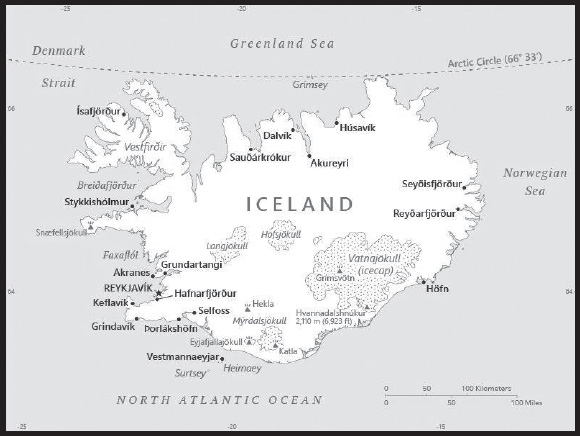
Location: Northern Europe, island between the Greenland Sea and the North Atlantic Ocean, northwest of the United Kingdom
Geographic coordinates: 65 00 N, 18 00 W
Map references: Arctic Region
Area: total: 103,000 sq km
land: 100,250 sq km:
water: 2,750 sq km
comparison ranking: total 108
Area - comparative: slightly smaller than Pennsylvania; about the same size as Kentucky
Land boundaries: total: 0 km
Coastline: 4,970 km
Maritime claims: territorial sea: 12 nm
exclusive economic zone: 200 nm
continental shelf: 200 nm or to the edge of the continental margin
Climate: temperate; moderated by North Atlantic Current; mild, windy winters; damp, cool summers
Terrain: mostly plateau interspersed with mountain peaks, icefields; coast deeply indented by bays and fiords
Elevation: highest point: Hvannadalshnukur (at Vatnajokull Glacier) 2,110 m
lowest point: Atlantic Ocean 0 m
mean elevation: 557 m
Natural resources: fish, hydropower, geothermal power, diatomite
Land use: agricultural land: 18.7% (2018 est.)
arable land: 1.2% (2018 est.)
permanent crops: 0% (2018 est.)
permanent pasture: 17.5% (2018 est.)
forest: 0.3% (2018 est.)
other: 81% (2018 est.)
Irrigated land: 0.5 sq km (2020)
Population distribution: Iceland is almost entirely urban with half of the population located in and around the capital of Reykjavik; smaller clusters are primarily found along the coast in the north and west
Natural hazards: earthquakes and volcanic activity
volcanism: Iceland, situated on top of a hotspot, experiences severe volcanic activity; Eyjafjallajokull (1,666 m) erupted in 2010, sending ash high into the atmosphere and seriously disrupting European air traffic; scientists continue to monitor nearby Katla (1,512 m), which has a high probability of eruption in the very near future, potentially disrupting air traffic; Grimsvoetn and Hekla are Iceland’s most active volcanoes; other historically active volcanoes include Askja, Bardarbunga, Brennisteinsfjoll, Esjufjoll, Hengill, Krafla, Krisuvik, Kverkfjoll, Oraefajokull, Reykjanes, Torfajokull, and Vestmannaeyjar
Geography - note: strategic location between Greenland and Europe; westernmost European country; Reykjavik is the northernmost national capital in the world; more land covered by glaciers than in all of continental Europe
PEOPLE AND SOCIETY
Population: 360,872 (2023 est.)
comparison ranking: 177
Nationality: noun: Icelander(s)
adjective: Icelandic
Ethnic groups: Icelandic 81.3%, Polish 5.6%, Danish 1%, other 12.1% (2021 est.)
note: data represent population by country of birth
Languages: Icelandic, English, Nordic languages, German
Religions: Evangelical Lutheran Church of Iceland (official) 62.3%, Roman Catholic 4%, Independent Congregation of Reykjavik 2.7%, Independent Congregation of Hafnarfjordur 2%, pagan worship 1.4%, Icelandic Ethical Humanist Association 1.1%, other (includes Zuist and Pentecostal) or unspecified 19%, none 7.6% (2021 est.)
Demographic profile: Iceland is one of the most gender-equal countries in the world. Its welfare policies enable both men and women to balance work and family life. Iceland lagged its Nordic neighbors in introducing new childcare policies, and even when they did in the 1990s, parents still faced a childcare gap between the paid parental leave period and the start of pre-school. The female labor participation rate continued to grow from the 1960s to the 2000s, as women’s educational attainment increased. Icelanders are marrying later, if they marry at all, and people are having children later. The interval between births has decreased. Non-marital cohabitation and childbearing outside of marriage are common. Approximately 2 out of 3 children are born out of wedlock, which is among the highest in Europe. Iceland’s total fertility rate (TFR) has been fairly stable, hovering around replacement level (2.1 children per woman), for decades – a rate higher even than its Nordic neighbors.
Iceland has fluctuated over time between being a country of net emigration and one of net immigration. Most Icelandic emigrants return to their native country after a few years. From 1960 to 1996, Iceland registered a net outflow, followed by a net inflow until the 2008 banking crisis. During and after the crisis, more Icelanders left the country than immigrated to it. Following the crisis, Iceland returned to being a country of net immigration. In 2017, the country’s foreign-born population accounted for 11% of the population and 17% had an immigrant background. The countries of origin have become more diverse over time, with Polish immigrants composing the largest share in 2017. Foreigners acquiring Icelandic citizenship must have a basic comprehension of the Icelandic language. The requirement that new citizens modify or change their names to be more Icelandic was dropped in 1996. The most popular emigration destination was Sweden, followed by Denmark and Norway in 2021.
Age structure: 0-14 years: 19.98% (male 36,771/female 35,314)
15-64 years: 63.39% (male 115,547/female 113,212)
65 years and over: 16.63% (2023 est.) (male 28,410/female 31,618)
Dependency ratios: total dependency ratio: 50.5
youth dependency ratio: 28
elderly dependency ratio: 22.5
potential support ratio: 4.5 (2021 est.)
Median age: total: 37.1 years (2020)
male: 36.6 years
female: 37.7 years
comparison ranking: total 74
Population growth rate: 0.89% (2023 est.)
comparison ranking: 104
Birth rate: 12.8 births/1,000 population (2023 est.)
comparison ranking: 139
Death rate: 6.57 deaths/1,000 population (2023 est.)
comparison ranking: 133
Net migration rate: 2.69 migrant(s)/1,000 population (2023 est.)
comparison ranking: 42
Population distribution: Iceland is almost entirely urban with half of the population located in and around the capital of Reykjavik; smaller clusters are primarily found along the coast in the north and west
Urbanization: urban population: 94% of total population (2023)
rate of urbanization: 0.74% annual rate of change (2020-25 est.)
Major urban areas - population: 216,000 REYKJAVIK (capital) (2018)
Sex ratio: at birth: 1.05 male(s)/female
0-14 years: 1.04 male(s)/female
15-64 years: 1.02 male(s)/female
65 years and over: 0.9 male(s)/female
total population: 1 male(s)/female (2023 est.)
Mother’s mean age at first birth: 28.7 years (2020 est.)
Maternal mortality ratio: 3 deaths/100,000 live births (2020 est.)
comparison ranking: 180
Infant mortality rate: total: 1.63 deaths/1,000 live births (2023 est.)
male: 1.82 deaths/1,000 live births
female: 1.44 deaths/1,000 live births
comparison ranking: total 225
Life expectancy at birth: total population: 83.83 years (2023 est.)
male: 81.61 years
female: 86.15 years
comparison ranking: total population 7
Total fertility rate: 1.95 children born/woman (2023 est.)
comparison ranking: 114
Gross reproduction rate: 0.95 (2023 est.)
Drinking water source: improved: total: 100% of population
unimproved: total: 0% of population (2020 est.)
Current health expenditure: 9.6% of GDP (2020)
Physicians density: 4.14 physicians/1,000 population (2019)
Hospital bed density: 2.8 beds/1,000 population (2019)
Sanitation facility access: improved: total: 100% of population
unimproved: total: 0% of population (2020 est.)
Obesity - adult prevalence rate: 21.9% (2016)
comparison ranking: 83
Alcohol consumption per capita: total: 7.72 liters of pure alcohol (2019 est.)
beer: 4.39 liters of pure alcohol (2019 est.)
wine: 2.11 liters of pure alcohol (2019 est.)
spirits: 1.22 liters of pure alcohol (2019 est.)
other alcohols: 0 liters of pure alcohol (2019 est.)
comparison ranking: total 49
Tobacco use: total: 12% (2020 est.)
male: 11.9% (2020 est.)
female: 12% (2020 est.)
comparison ranking: total 122
Currently married women (ages 15-49): 45.1% (2023 est.)
Education expenditures: 7.7% of GDP (2020 est.)
comparison ranking: 13
School life expectancy (primary to tertiary education): total: 19 years
male: 18 years
female: 21 years (2020)
Youth unemployment rate (ages 15-24): total: 13.4% (2021 est.)
male: 13%
female: 13.7%
comparison ranking: total 132
ENVIRONMENT
Environment - current issues: water pollution from fertilizer runoff
Environment - international agreements: party to: Air Pollution, Air Pollution-Persistent Organic Pollutants, Antarctic Treaty, Biodiversity, Climate Change, Climate Change-Kyoto Protocol, Climate Change-Paris Agreement, Comprehensive Nuclear Test Ban, Desertification, Endangered Species, Hazardous Wastes, Law of the Sea, Marine Dumping-London Convention, Marine Dumping- London Protocol, Nuclear Test Ban, Ozone Layer Protection, Ship Pollution, Wetlands, Whaling
signed, but not ratified: Air Pollution-Heavy Metals, Environmental Modification, Marine Life Conservation
Climate: temperate; moderated by North Atlantic Current; mild, windy winters; damp, cool summers
Land use: agricultural land: 18.7% (2018 est.)
arable land: 1.2% (2018 est.)
permanent crops: 0% (2018 est.)
permanent pasture: 17.5% (2018 est.)
forest: 0.3% (2018 est.)
other: 81% (2018 est.)
Urbanization: urban population: 94% of total population (2023)
rate of urbanization: 0.74% annual rate of change (2020-25 est.)
Revenue from forest resources: 0% of GDP (2018 est.)
comparison ranking: 164
Revenue from coal: 0% of GDP (2018 est.)
comparison ranking: 153
Air pollutants: particulate matter emissions: 5.79 micrograms per cubic meter (2019 est.)
carbon dioxide emissions: 2.06 megatons (2016 est.)
methane emissions: 0.59 megatons (2020 est.)
Waste and recycling: municipal solid waste generated annually: 525,000 tons (2015 est.)
municipal solid waste recycled annually: 293,003 tons (2013 est.)
percent of municipal solid waste recycled: 55.8% (2013 est.)
Total water withdrawal: municipal: 80 million cubic meters (2020 est.)
industrial: 200 million cubic meters (2020 est.)
agricultural: 300,000 cubic meters (2017 est.)
Total renewable water resources: 170 billion cubic meters (2020 est.)
GOVERNMENT
Country name: conventional long form: none
conventional short form: Iceland
local long form: none
local short form: Island
etymology: Floki VILGERDARSON, an early Norse explorer of the island (9th century), applied the name “Land of Ice” after spotting a fjord full of drift ice to the north and spending a bitter winter on the island; he eventually settled on the island, however, after he saw how it greened up in the summer and that it was, in fact, habitable
Government type: unitary parliamentary republic
Capital: name: Reykjavik
geographic coordinates: 64 09 N, 21 57 W
time difference: UTC 0 (5 hours ahead of Washington, DC, during Standard Time)
etymology: the name means “smoky bay” in Icelandic and refers to the steamy, smoke-like vapors discharged by hot springs in the area
Administrative divisions: 64 municipalities (sveitarfelog, singular - sveitarfelagidh); Akranes, Akureyri, Arneshreppur, Asahreppur, Blaskogabyggdh, Bolungarvik, Borgarbyggdh, Dalabyggdh, Dalvikurbyggdh, Eyjafjardharsveit, Eyja-og Miklaholtshreppur, Fjallabyggdh, Fjardhabyggdh, Fljotsdalshreppur, Floahreppur, Gardhabaer, Grimsnes-og Grafningshreppur, Grindavikurbaer, Grundarfjardharbaer, Grytubakkahreppur, Hafnarfjordhur, Horgarsveit, Hrunamannahreppur, Hunathing Vestra, Hunabyggdh, Hvalfjardharsveit, Hveragerdhi, Isafjardharbaer, Kaldrananeshreppur, Kjosarhreppur, Kopavogur, Langanesbyggdh, Mosfellsbaer, Mulathing, Myrdalshreppur, Nordhurthing, Rangarthing Eystra, Rangarthing Ytra, Reykholahreppur, Reykjanesbaer, Reykjavik, Seltjarnarnes, Skaftarhreppur, Skagabyggdh, Skagafjordhur, Skeidha-og Gnupverjahreppur, Skorradalshreppur, Snaefellsbaer, Strandabyggdh, Stykkisholmur, Sudhavikurhreppur, Sudhurnesjabaer, Svalbardhsstrandarhreppur, Sveitarfelagidh Arborg, Sveitarfelagidh Hornafjordhur, Sveitarfelagidh Olfus, Sveitarfelagidh Skagastrond, Sveitarfelagidh Vogar, Talknafjardharhreppur, Thingeyjarsveit, Tjorneshreppur, Vestmannaeyjar, Vesturbyggdh, Vopnafjardharhreppur
Independence: 1 December 1918 (became a sovereign state under the Danish Crown); 17 June 1944 (from Denmark; birthday of Jon SIGURDSSON, leader of Iceland’s 19th Century independence movement)
National holiday: Independence Day, 17 June (1944)
Constitution: history: several previous; latest ratified 16 June 1944, effective 17 June 1944 (at independence)
amendments: proposed by the Althingi; passage requires approval by the Althingi and by the next elected Althingi, and confirmation by the president of the republic; proposed amendments to Article 62 of the constitution – that the Evangelical Lutheran Church shall be the state church of Iceland – also require passage by referendum; amended many times, last in 2013
Legal system: civil law system influenced by the Danish model
International law organization participation: has not submitted an ICJ jurisdiction declaration; accepts ICCt jurisdiction
Citizenship: citizenship by birth: no
citizenship by descent only: at least one parent must be a citizen of Iceland
dual citizenship recognized: yes
residency requirement for naturalization: 3 to 7 years
Suffrage: 18 years of age; universal
Executive branch: chief of state: President Gudni Thorlacius JOHANNESSON (since 1 August 2016)
head of government: Prime Minister Katrin JAKOBSDOTTIR (since 30 November 2017)
cabinet: Cabinet appointed by the president upon the recommendation of the prime minister
elections/appointments: president directly elected by simple majority popular vote for a 4-year term (no term limits); election last held on 27 June 2020 (next to be held in 2024); following legislative elections, the leader of the majority party or majority coalition becomes prime minister
election results:
2020: Gudni Thorlacius JOHANNESSON reelected president; percent of vote - Gudni Thorlacius JOHANNESSON (independent) 92.2%, Gudmundur Franklin JONSSON (independent) 7.8%
2016: Gudni Thorlacius JOHANNESSON elected president; Gudni Thorlacius JOHANNESSON (independent) 39.1%, Halla TOMASDOTTIR (independent) 27.9%, Andri Snær MAGNASON (Democracy Movement) 14.3%, David ODDSSON (independent) 13.7%, other 5%
Legislative branch: description: unicameral Althingi or Parliament (63 seats; members directly elected in multi-seat constituencies by closed-list proportional representation vote using the D’Hondt method; members serve 4-year terms)
elections: last held on 25 September 2021 (next to be held in 2025)
election results:
percent of vote by party - IP 25.4%, PP 20.6%, LGM 12.7%, People’s Party 9.5%, Pirate Party 9.5%, SDA 9.5%, Reform Party 7.9%, CP 4.8%; seats by party - IP 16, PP 13, LGM 8, People’s Party 6, Pirate Party 6, SDA 6, Reform Party 5, CP 3; composition - men 33, women 30; percent of women 47.6%
Judicial branch: highest court(s): Supreme Court or Haestirettur (consists of 9 judges)
judge selection and term of office: judges proposed by Ministry of Interior selection committee and appointed by the president; judges appointed for an indefinite period
subordinate courts: Appellate Court or Landsrettur; 8 district courts; Labor Court
Political parties and leaders: Centrist Party (Midflokkurinn) or CP [Sigmundur David GUNNLAUGSSON]
Independence Party (Sjalfstaedisflokkurinn) or IP [Bjarni BENEDIKTSSON]
Left-Green Movement (Vinstrihreyfingin-graent frambod) or LGM [Katrin JAKOBSDOTTIR]
People’s Party (Flokkur Folksins) [Inga SAELAND]
Pirate Party (Piratar) [Thorhildur Sunna AEVARSDOTTIR]
Progressive Party (Framsoknarflokkurinn) or PP [Sigurdur Ingi JOHANNSSON]
Reform Party (Vidreisn) [Thorgerdur Katrin GUNNARSDOTTIR]
Social Democratic Alliance (Samfylkingin) or SDA [Kristrun FROSTADOTTIR]
International organization participation: Arctic Council, Australia Group, BIS, CBSS, CD, CE, EAPC, EBRD, EFTA, FAO, FATF, IAEA, IBRD, ICAO, ICC (national committees), ICCt, ICRM, IDA, IFAD, IFC, IFRCS, IHO, ILO, IMF, IMO, IMSO, Interpol, IOC, IOM, IPU, ISO, ITSO, ITU, ITUC (NGOs), MIGA, NATO, NC, NEA, NIB, NSG, OAS (observer), OECD, OPCW, OSCE, PCA, Schengen Convention, UN, UNCTAD, UNESCO, UPU, WCO, WHO, WIPO, WMO, WTO
Diplomatic representation in the US: chief of mission: Ambassador Bergdis ELLERTSDOTTIR (since 16 September 2019)
chancery: House of Sweden, 2900 K Street NW, #509, Washington, DC 20007
telephone: [1] (202) 265-6653
FAX: [1] (202) 265-6656
email address and website:
https://www.government.is/diplomatic-missions/embassy-of-iceland-in-washington-d.c/
consulate(s) general: New York
Diplomatic representation from the US: chief of mission: Ambassador Carrin F. PATMAN (since 6 October 2022)
embassy: Engjateigur 7, 105 Reykjavik
mailing address: 5640 Reykjavik Place, Washington, D.C. 20521-5640
telephone: [354] 595-2200
FAX: [354] 562-9118
email address and website:
Flag description: blue with a red cross outlined in white extending to the edges of the flag; the vertical part of the cross is shifted to the hoist side in the style of the Dannebrog (Danish flag); the colors represent three of the elements that make up the island: red is for the island’s volcanic fires, white recalls the snow and ice fields of the island, and blue is for the surrounding ocean
National symbol(s): gyrfalcon; national colors: blue, white, red
National anthem: name: “Lofsongur” (Song of Praise)
lyrics/music: Matthias JOCHUMSSON/Sveinbjorn SVEINBJORNSSON
note: adopted 1944; also known as “O, Gud vors lands” (O, God of Our Land), the anthem was originally written and performed in 1874
National heritage: total World Heritage Sites: 3 (1 cultural, 2 natural)
selected World Heritage Site locales: Thingvellir National Park (c); Surtsey (n); Vatnajökull National Park - Dynamic Nature of Fire and Ice (n)
ECONOMY
Economic overview: high-income European economy; frozen EU accession application but Schengen Area member; major tourism, fishing, and aluminum industries; complex regulatory environment; large FDI recipient; highly educated workforce
Real GDP (purchasing power parity): $19.962 billion (2021 est.)
$19.12 billion (2020 est.)
$20.524 billion (2019 est.)
note: data are in 2017 dollars
comparison ranking: 153
Real GDP growth rate: 4.4% (2021 est.)
-6.84% (2020 est.)
2.42% (2019 est.)
comparison ranking: 105
Real GDP per capita: $53,600 (2021 est.)
$52,200 (2020 est.)
$56,900 (2019 est.)
note: data are in 2017 dollars
comparison ranking: 25
GDP (official exchange rate): $24.614 billion (2019 est.)
Inflation rate (consumer prices): 4.44% (2021 est.)
2.85% (2020 est.)
3.01% (2019 est.)
comparison ranking: 79
Credit ratings: Fitch rating: A (2017)
Moody’s rating: A2 (2019)
Standard & Poors rating: A (2017)
note: The year refers to the year in which the current credit rating was first obtained.
GDP - composition, by sector of origin: agriculture: 5.8% (2017 est.)
industry: 19.7% (2017 est.)
services: 74.6% (2017 est.)
comparison rankings: services 48; industry 150; agriculture 122
GDP - composition, by end use: household consumption: 50.4% (2017 est.)
government consumption: 23.3% (2017 est.)
investment in fixed capital: 22.1% (2017 est.)
investment in inventories: 0% (2017 est.)
exports of goods and services: 47% (2017 est.)
imports of goods and services: -42.8% (2017 est.)
Agricultural products: milk, mutton, poultry, potatoes, barley, pork, eggs, beef, other meat, sheep skins
Industries: tourism, fish processing; aluminum smelting; geothermal power, hydropower; medical/pharmaceutical products
Industrial production growth rate: 5.65% (2021 est.)
comparison ranking: 77
Labor force: 200,300 (2021 est.)
comparison ranking: 177
Labor force - by occupation: agriculture: 4.8%
industry: 22.2%
services: 73% (2008)
Unemployment rate: 5.4% (2021 est.)
5.48% (2020 est.)
3.51% (2019 est.)
comparison ranking: 137
Youth unemployment rate (ages 15-24): total: 13.4% (2021 est.)
male: 13%
female: 13.7%
comparison ranking: total 132
Population below poverty line: 8.8% (2017 est.)
Gini Index coefficient - distribution of family income: 26.1 (2017 est.)
comparison ranking: 168
Budget: revenues: $11.776 billion (2018 est.)
expenditures: $11.536 billion (2018 est.)
Budget surplus (+) or deficit (-): 1.5% (of GDP) (2017 est.)
comparison ranking: 23
Public debt: 100.02% of GDP (2020 est.)
89.59% of GDP (2019 est.)
81.95% of GDP (2018 est.)
comparison ranking: 24
Taxes and other revenues: 22.33% (of GDP) (2020 est.)
comparison ranking: 68
Fiscal year: calendar year
Current account balance: -$409.262 million (2021 est.)
$407.806 million (2020 est.)
$1.612 billion (2019 est.)
comparison ranking: 114
Exports: $9.775 billion (2021 est.) note: data are in current year dollars
$7.501 billion (2020 est.) note: data are in current year dollars
$11.005 billion (2019 est.) note: data are in current year dollars
comparison ranking: 106
Exports - partners: Netherlands 24%, Spain 10%, Germany 10%, United Kingdom 9%, United States 7% (2021)
Exports - commodities: aluminum and aluminum products, fish fillets, salmon, iron alloys, animal meal (2021)
Imports: $10.234 billion (2021 est.) note: data are in current year dollars
$7.616 billion (2020 est.) note: data are in current year dollars
$9.891 billion (2019 est.) note: data are in current year dollars
comparison ranking: 114
Imports - partners: Norway 11%, Denmark 10%, Netherlands 9%, Germany 9%, China 7% (2021)
Imports - commodities: refined petroleum, aluminum oxide, carbon/graphite electronics, cars, packaged medicines (2019)
Reserves of foreign exchange and gold: $7.079 billion (31 December 2021 est.)
$6.419 billion (31 December 2020 est.)
$6.782 billion (31 December 2019 est.)
comparison ranking: 94
Debt - external: $19.422 billion (2019 est.)
$22.055 billion (2018 est.)
comparison ranking: 94
Exchange rates: Icelandic kronur (ISK) per US dollar -
Exchange rates: 126.989 (2021 est.)
135.422 (2020 est.) 122.607 (2019 est.)
108.3 (2018 est.)
106.84 (2017 est.)
ENERGY
Electricity access: electrification - total population: 100% (2021)
Electricity: installed generating capacity: 2.967 million kW (2020 est.)
consumption: 17,912,066,000 kWh (2020 est.)
exports: 0 kWh (2020 est.)
imports: 0 kWh (2020 est.)
transmission/distribution losses: 519 million kWh (2020 est.)
comparison rankings: transmission/distribution losses 129; imports 120; exports 100; consumption 74; installed generating capacity 108
Electricity generation sources: hydroelectricity: 67.6% of total installed capacity (2020 est.)
geothermal: 32.3% of total installed capacity (2020 est.)
Coal: production: 0 metric tons (2020 est.)
consumption: 142,000 metric tons (2020 est.)
exports: 0 metric tons (2020 est.)
imports: 136,000 metric tons (2020 est.)
proven reserves: 0 metric tons (2019 est.)
Petroleum: total petroleum production: 0 bbl/day (2021 est.)
refined petroleum consumption: 19,700 bbl/day (2019 est.)
Refined petroleum products - exports: 2,530 bbl/day (2017 est.)
comparison ranking: 101
Refined petroleum products - imports: 20,220 bbl/day (2017 est.)
comparison ranking: 120
Carbon dioxide emissions: 3.337 million metric tonnes of CO2 (2019 est.)
from coal and metallurgical coke: 459,000 metric tonnes of CO2 (2019 est.)
from petroleum and other liquids: 2.879 million metric tonnes of CO2 (2019 est.)
comparison ranking: total emissions 147
COMMUNICATIONS
Telephones - fixed lines: total subscriptions: 100,482 (2021 est.)
subscriptions per 100 inhabitants: 27 (2021 est.)
comparison ranking: total subscriptions 138
Telephones - mobile cellular: total subscriptions: 437,270 (2021 est.)
subscriptions per 100 inhabitants: 118 (2021 est.)
comparison ranking: total subscriptions 177
Telecommunication systems: general assessment: Iceland has one of the smallest yet most progressive telecom markets in Europe; the country in 2020 became the top in Europe for fiber penetration; it aims to provide a fixed broadband service of at least 100Mb/s to 99.9% of the population by the end of 2021, an ambitious target by international standards and one which it is likely to achieve given the progress which operators have made in extending the reach of fiber networks; there is effective competition in the mobile and broadband markets, with a number of players having emerged to challenge the dominance of the two leading operators which have interests across the telecom sectors; the telecom market has shown some resilience in recent years following the significant economic downturn a decade ago, supported by continuing investment in mobile and fixed-line broadband infrastructure by operators and well as by the government’s Telecommunications Fund which is supporting Next Generation Access networks, particularly in rural areas (2022)
domestic: 27 per 100 for fixed line and nearing 118 per 100 for mobile-cellular subscriptions (2021)
international: country code - 354; landing points for the CANTAT-3, FARICE-1, Greenland Connect and DANICE submarine cable system that provides connectivity to Canada, the Faroe Islands, Greenland, UK, Denmark, and Germany; satellite earth stations - 2 Intelsat (Atlantic Ocean), 1 Inmarsat (Atlantic and Indian Ocean regions); note - Iceland shares the Inmarsat earth station with the other Nordic countries (Denmark, Finland, Norway, and Sweden) (2019)
Broadcast media: state-owned public TV broadcaster (RUV) operates 21 TV channels nationally (RUV and RUV 2, though RUV 2 is used less frequently); RUV broadcasts nationally, every household in Iceland is required to have RUV as it doubles as the emergency broadcast network; RUV also operates stringer offices in the north (Akureyri) and the east (Egilsstadir) but operations are all run out of RUV headquarters in Reykjavik; there are 3 privately owned TV stations; Stod 2 (Channel 2) is owned by Syn, following 365 Media and Vodafone merger, and is headquartered in Reykjavik; Syn also operates 4 sports channels under Stod 2; N4 is the only television station headquartered outside of Reykjavik, in Akureyri, with local programming for the north, south, and east of Iceland; Hringbraut is the newest station and is headquartered in Reykjavik; all of these television stations have nationwide penetration as 100% of households have multi-channel services though digital and/or fiber-optic connections
RUV operates 3 radio stations (RAS 1, RAS2, and Rondo) as well as 4 regional stations (but they mostly act as range extenders for RUV radio broadcasts nationwide); there is 1 privately owned radio conglomerate, Syn (4 stations), that broadcasts nationwide, and 3 other radio stations that broadcast to the most densely populated regions of the country. In addition, there are upwards of 20 radio stations that operate regionally
(2019)
Internet country code: .is
Internet users: total: 370,000 (2021 est.)
percent of population: 100% (2021 est.)
comparison ranking: total 174
Broadband - fixed subscriptions: total: 141,816 (2020 est.)
subscriptions per 100 inhabitants: 42 (2020 est.)
comparison ranking: total 124
TRANSPORTATION
National air transport system: number of registered air carriers: 6 (2020)
inventory of registered aircraft operated by air carriers: 63
annual passenger traffic on registered air carriers: 7,819,740 (2018)
annual freight traffic on registered air carriers: 163.65 million (2018) mt-km
Civil aircraft registration country code prefix: TF
Airports: 96 (2021)
comparison ranking: total 60
Airports - with paved runways: 7
note: paved runways have a concrete or asphalt surface but not all have facilities for refueling, maintenance, or air traffic control; the length of a runway required for aircraft to safely operate depends on a number of factors including the type of aircraft, the takeoff weight (including passengers, cargo, and fuel), engine types, flap settings, landing speed, elevation of the airport, and average maximum daily air temperature; paved runways can reach a length of 5,000 m (16,000 ft.), but the “typical” length of a commercial airline runway is between 2,500-4,000 m (8,000-13,000 ft.)
Airports - with unpaved runways: 89
note: unpaved runways have a surface composition such as grass or packed earth and are most suited to the operation of light aircraft; unpaved runways are usually short, often less than 1,000 m (3,280 ft.) in length; airports with unpaved runways often lack facilities for refueling, maintenance, or air traffic control
Roadways: total: 12,898 km (2012)
paved/oiled gravel: 5,647 km (2012) (excludes urban roads)
unpaved: 7,251 km (2012)
comparison ranking: total 129
Merchant marine: total: 40 (2022)
by type: general cargo 5, oil tanker 2, other 33
comparison ranking: total 125
Ports and terminals: major seaport(s): Grundartangi, Hafnarfjordur, Reykjavik
MILITARY AND SECURITY
Military and security forces: no regular military forces; the Icelandic National Police, the nine regional police forces, and the Icelandic Coast Guard fall under the purview of the Ministry of Justice (2023)
note: the Icelandic Coast Guard is responsible for operational defense tasks in Iceland including but not limited to operation of Keflavik Air Base, special security zones, and Iceland’s air defense systems
Military equipment inventories and acquisitions: the Icelandic Coast Guard’s inventory consists of equipment from mostly European suppliers (2023)
Military - note: Iceland was one of the original 12 countries to sign the North Atlantic Treaty (also known as the Washington Treaty) in 1949; Iceland is the only NATO member that has no standing military force; defense of Iceland remains a NATO commitment and NATO maintains an air policing presence in Icelandic airspace; Iceland participates in international peacekeeping missions with the civilian-manned Icelandic Crisis Response Unit (ICRU)
Iceland cooperates with the militaries of other Nordic countries through the Nordic Defense Cooperation (NORDEFCO), which consists of Denmark, Finland, Iceland, Norway, and Sweden; areas of cooperation include armaments, education, human resources, training and exercises, and operations; NORDEFCO was established in 2009
in 1951, Iceland and the US concluded an agreement to make arrangements regarding the defense of Iceland and for the use of facilities in Iceland to that end; the agreement, along with NATO membership, is one of the two pillars of Iceland’s security policy; since 2007 Iceland has concluded cooperation agreements with Canada, Denmark, Norway, and the UK; it also has regular consultations with Germany and France on security and defense (2023)
TRANSNATIONAL ISSUES
Disputes - international: in 2019, Denmark signed continental shelf delimitation agreements with Iceland and Norway to parts of the continental shelf in the Ægir Basin, which is located north of the Faroe Islands
Refugees and internally displaced persons: stateless persons: 68 (2022)
INTRODUCTION
Background: The Indus Valley civilization, one of the world’s oldest, flourished during the 3rd and 2nd millennia B.C. and extended into northwestern India. Aryan tribes from the northwest infiltrated the Indian subcontinent about 1500 B.C.; their merger with the earlier Dravidian inhabitants created the classical Indian culture. The Maurya Empire of the 4th and 3rd centuries B.C. - which reached its zenith under ASHOKA - united much of South Asia. The Golden Age ushered in by the Gupta dynasty (4th to 6th centuries A.D.) saw a flowering of Indian science, art, and culture. Islam spread across the subcontinent over a period of 700 years. In the 10th and 11th centuries, Turks and Afghans invaded India and established the Delhi Sultanate. In the early 16th century, the Emperor BABUR established the Mughal Dynasty, which ruled India for more than three centuries. European explorers began establishing footholds in India during the 16th century.
By the 19th century, Great Britain had become the dominant political power on the subcontinent and India was seen as the “Jewel in the Crown” of the British Empire. The British Indian Army played a vital role in both World Wars. Years of nonviolent resistance to British rule, led by Mohandas GANDHI and Jawaharlal NEHRU, eventually resulted in Indian independence in 1947. Large-scale communal violence took place before and after the subcontinent partition into two separate states - India and Pakistan. The neighboring countries have fought three wars since independence, the last of which was in 1971 and resulted in East Pakistan becoming the separate nation of Bangladesh. India’s nuclear weapons tests in 1998 emboldened Pakistan to conduct its own tests that same year. In November 2008, terrorists originating from Pakistan conducted a series of coordinated attacks in Mumbai, India’s financial capital. India’s economic growth following the launch of economic reforms in 1991, a massive youthful population, and a strategic geographic location have contributed to India’s emergence as a regional and global power. However, India still faces pressing problems such as environmental degradation, extensive poverty, and widespread corruption, and its restrictive business climate challenges economic growth expectations.
GEOGRAPHY
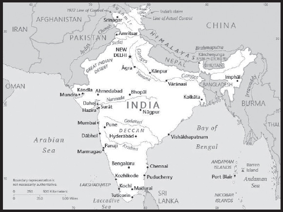
Location: Southern Asia, bordering the Arabian Sea and the Bay of Bengal, between Burma and Pakistan
Geographic coordinates: 20 00 N, 77 00 E
Map references: Asia
Area: total: 3,287,263 sq km
land: 2,973,193 sq km
water: 314,070 sq km
comparison ranking: total 8
Area - comparative: slightly more than one-third the size of the US
Land boundaries: total: 13,888 km
border countries (6): Bangladesh 4,142 km; Bhutan 659 km; Burma 1,468 km; China 2,659 km; Nepal 1,770 km; Pakistan 3,190 km
Coastline: 7,000 km
Maritime claims: territorial sea: 12 nm
contiguous zone: 24 nm
exclusive economic zone: 200 nm
continental shelf: 200 nm or to the edge of the continental margin
Climate: varies from tropical monsoon in south to temperate in north
Terrain: upland plain (Deccan Plateau) in south, flat to rolling plain along the Ganges, deserts in west, Himalayas in north
Elevation: highest point: Kanchenjunga 8,586 m
lowest point: Indian Ocean 0 m
mean elevation: 160 m
Natural resources: coal (fourth-largest reserves in the world), antimony, iron ore, lead, manganese, mica, bauxite, rare earth elements, titanium ore, chromite, natural gas, diamonds, petroleum, limestone, arable land
Land use: agricultural land: 60.5% (2018 est.)
arable land: 52.8% (2018 est.)
permanent crops: 4.2% (2018 est.)
permanent pasture: 3.5% (2018 est.)
forest: 23.1% (2018 est.)
other: 16.4% (2018 est.)
Irrigated land: 715,539 sq km (2020)
Major lakes (area sq km): salt water lake(s): Chilika Lake - 1,170 sq km
Major rivers (by length in km): Brahmaputra (shared with China [s] and Bangladesh [m]) - 3,969 km; Indus (shared with China [s] and Pakistan [m]) - 3,610 km; Ganges river source (shared with Bangladesh [m]) - 2,704 km; Godavari - 1,465 km; Sutlej (shared with China [s] and Pakistan [m]) - 1,372 km; Yamuna - 1,370 km; Narmada - 1,289 km; Chenab river source (shared with Pakistan [m]) - 1,086 km; Ghaghara river mouth (shared with China [s] and Nepal) - 1,080 km
note – [s] after country name indicates river source; [m] after country name indicates river mouth
Major watersheds (area sq km): Indian Ocean drainage: Brahmaputra (651,335 sq km), Ganges (1,016,124 sq km), Indus (1,081,718 sq km), Irrawaddy (413,710 sq km)
Major aquifers: Indus-Ganges-Brahmaputra Basin
Population distribution: with the notable exception of the deserts in the northwest, including the Thar Desert, and the mountain fringe in the north, a very high population density exists throughout most of the country; the core of the population is in the north along the banks of the Ganges, with other river valleys and southern coastal areas also having large population concentrations
Natural hazards: droughts; flash floods, as well as widespread and destructive flooding from monsoonal rains; severe thunderstorms; earthquakes
volcanism: Barren Island (354 m) in the Andaman Sea has been active in recent years
Geography - note: dominates South Asian subcontinent; near important Indian Ocean trade routes; Kanchenjunga, third tallest mountain in the world, lies on the border with Nepal
PEOPLE AND SOCIETY
Population: 1,399,179,585 (2023 est.)
comparison ranking: 2
Nationality: noun: Indian(s)
adjective: Indian
Ethnic groups: Indo-Aryan 72%, Dravidian 25%, and other 3% (2000)
Languages: Hindi 43.6%, Bengali 8%, Marathi 6.9%, Telugu 6.7%, Tamil 5.7%, Gujarati 4.6%, Urdu 4.2%, Kannada 3.6%, Odia 3.1%, Malayalam 2.9%, Punjabi 2.7%, Assamese 1.3%, Maithili 1.1%, other 5.6%; note - English enjoys the status of subsidiary official language but is the most important language for national, political, and commercial communication; there are 22 other officially recognized languages: Assamese, Bengali, Bodo, Dogri, Gujarati, Hindi, Kannada, Kashmiri, Konkani, Maithili, Malayalam, Manipuri, Marathi, Nepali, Odia, Punjabi, Sanskrit, Santali, Sindhi, Tamil, Telugu, Urdu; Hindustani is a popular variant of Hindi/Urdu spoken widely throughout northern India but is not an official language (2011 est.)
major-language sample(s):
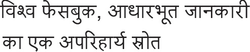
(Hindi)
Religions: Hindu 79.8%, Muslim 14.2%, Christian 2.3%, Sikh 1.7%, other and unspecified 2% (2011 est.)
Age structure: 0-14 years: 24.77% (male 182,143,540/female 164,492,120)
15-64 years: 68.42% (male 494,814,550/female 462,533,456)
65 years and over: 6.8% (2023 est.) (male 43,860,101/female 51,335,818)
Dependency ratios: total dependency ratio: 48.1
youth dependency ratio: 38.1
elderly dependency ratio: 10.1
potential support ratio: 9.9 (2021 est.)
Median age: total: 28.7 years (2020)
male: 28 years
female: 29.5 years
comparison ranking: total 141
Population growth rate: 0.7% (2023 est.)
comparison ranking: 127
Birth rate: 16.53 births/1,000 population (2023 est.)
comparison ranking: 94
Death rate: 9.65 deaths/1,000 population (2023 est.)
comparison ranking: 40
Net migration rate: 0.12 migrant(s)/1,000 population (2023 est.)
comparison ranking: 79
Population distribution: with the notable exception of the deserts in the northwest, including the Thar Desert, and the mountain fringe in the north, a very high population density exists throughout most of the country; the core of the population is in the north along the banks of the Ganges, with other river valleys and southern coastal areas also having large population concentrations
Urbanization: urban population: 36.4% of total population (2023)
rate of urbanization: 2.33% annual rate of change (2020-25 est.)
Major urban areas - population: 32.941 million NEW DELHI (capital), 21.297 million Mumbai, 15.333 million Kolkata, 13.608 million Bangalore, 11.776 million Chennai, 10.801 million Hyderabad (2023)
Sex ratio: at birth: 1.1 male(s)/female
0-14 years: 1.11 male(s)/female
15-64 years: 1.07 male(s)/female
65 years and over: 0.85 male(s)/female
total population: 1.06 male(s)/female (2023 est.)
Mother’s mean age at first birth: 21.2 years (2019/21)
note: data represents median age at first birth among women 25-49
Maternal mortality ratio: 103 deaths/100,000 live births (2020 est.)
comparison ranking: 68
Infant mortality rate: total: 30.36 deaths/1,000 live births (2023 est.)
male: 29.99 deaths/1,000 live births
female: 30.77 deaths/1,000 live births
comparison ranking: total 49
Life expectancy at birth: total population: 67.69 years (2023 est.)
male: 65.95 years
female: 69.61 years
comparison ranking: total population 191
Total fertility rate: 2.07 children born/woman (2023 est.)
comparison ranking: 95
Gross reproduction rate: 0.98 (2023 est.)
Contraceptive prevalence rate: 66.7% (2019/20)
Drinking water source: improved: urban: 96.9% of population
rural: 94.7% of population
total: 95.5% of population
unimproved: urban: 3.1% of population
rural: 5.3% of population
total: 4.5% of population (2020 est.)
Current health expenditure: 3% of GDP (2020)
Physicians density: 0.74 physicians/1,000 population (2020)
Hospital bed density: 0.5 beds/1,000 population (2017)
Sanitation facility access: improved: urban: 98.6% of population
rural: 75.2% of population
total: 83.4% of population
unimproved: urban: 1.4% of population
rural: 24.8% of population
total: 16.6% of population (2020 est.)
Major infectious diseases: degree of risk: very high (2023)
food or waterborne diseases: bacterial diarrhea, hepatitis A and E, and typhoid fever
vectorborne diseases: dengue fever, Crimean-Congo hemorrhagic fever, Japanese encephalitis, and malaria
water contact diseases: leptospirosis
animal contact diseases: rabies
Obesity - adult prevalence rate: 3.9% (2016)
comparison ranking: 189
Alcohol consumption per capita: total: 3.09 liters of pure alcohol (2019 est.)
beer: 0.23 liters of pure alcohol (2019 est.)
wine: 0 liters of pure alcohol (2019 est.)
spirits: 2.85 liters of pure alcohol (2019 est.)
other alcohols: 0 liters of pure alcohol (2019 est.)
comparison ranking: total 111
Tobacco use: total: 27.2% (2020 est.)
male: 41.3% (2020 est.)
female: 13% (2020 est.)
comparison ranking: total 40
Children under the age of 5 years underweight: 31.5% (2019/21)
comparison ranking: 5
Currently married women (ages 15-49): 72.6% (2023 est.)
Child marriage: women married by age 15: 4.8%
women married by age 18: 23.3%
men married by age 18: 2.6% (2021 est.)
Education expenditures: 4.5% of GDP (2020 est.)
comparison ranking: 100
Literacy: definition: age 15 and over can read and write
total population: 74.4%
male: 82.4%
female: 65.8% (2018)
School life expectancy (primary to tertiary education): total: 12 years
male: 12 years
female: 12 years (2020)
Youth unemployment rate (ages 15-24): total: 28.3% (2021 est.)
male: 28.6%
female: 26.7%
comparison ranking: total 46
ENVIRONMENT
Environment - current issues: deforestation; soil erosion; overgrazing; desertification; air pollution from industrial effluents and vehicle emissions; water pollution from raw sewage and runoff of agricultural pesticides; tap water is not potable throughout the country; huge and growing population is overstraining natural resources; preservation and quality of forests; biodiversity loss
Environment - international agreements: party to: Antarctic-Environmental Protection, Antarctic-Marine Living Resources, Antarctic Treaty, Biodiversity, Climate Change, Climate Change-Kyoto Protocol, Climate Change-Paris Agreement, Desertification, Endangered Species, Environmental Modification, Hazardous Wastes, Law of the Sea, Nuclear Test Ban, Ozone Layer Protection, Ship Pollution, Tropical Timber 2006, Wetlands, Whaling
signed, but not ratified: none of the selected agreements
Climate: varies from tropical monsoon in south to temperate in north
Land use: agricultural land: 60.5% (2018 est.)
arable land: 52.8% (2018 est.)
permanent crops: 4.2% (2018 est.)
permanent pasture: 3.5% (2018 est.)
forest: 23.1% (2018 est.)
other: 16.4% (2018 est.)
Urbanization: urban population: 36.4% of total population (2023)
rate of urbanization: 2.33% annual rate of change (2020-25 est.)
Revenue from forest resources: 0.14% of GDP (2018 est.)
comparison ranking: 103
Revenue from coal: 1.15% of GDP (2018 est.)
comparison ranking: 4
Air pollutants: particulate matter emissions: 50.17 micrograms per cubic meter (2019 est.)
carbon dioxide emissions: 2,407.67 megatons (2016 est.)
methane emissions: 559.11 megatons (2020 est.)
Waste and recycling: municipal solid waste generated annually: 168,403,240 tons (2001 est.)
municipal solid waste recycled annually: 8,420,162 tons (2013 est.)
percent of municipal solid waste recycled: 5% (2013 est.)
Major lakes (area sq km): salt water lake(s): Chilika Lake - 1,170 sq km
Major rivers (by length in km): Brahmaputra (shared with China [s] and Bangladesh [m]) - 3,969 km; Indus (shared with China [s] and Pakistan [m]) - 3,610 km; Ganges river source (shared with Bangladesh [m]) - 2,704 km; Godavari - 1,465 km; Sutlej (shared with China [s] and Pakistan [m]) - 1,372 km; Yamuna - 1,370 km; Narmada - 1,289 km; Chenab river source (shared with Pakistan [m]) - 1,086 km; Ghaghara river mouth (shared with China [s] and Nepal) - 1,080 km
note – [s] after country name indicates river source; [m] after country name indicates river mouth
Major watersheds (area sq km): Indian Ocean drainage: Brahmaputra (651,335 sq km), Ganges (1,016,124 sq km), Indus (1,081,718 sq km), Irrawaddy (413,710 sq km)
Major aquifers: Indus-Ganges-Brahmaputra Basin
Total water withdrawal: municipal: 56 billion cubic meters (2020 est.)
industrial: 17 billion cubic meters (2020 est.)
agricultural: 688 billion cubic meters (2020 est.)
Total renewable water resources: 1.91 trillion cubic meters (2019 est.)
GOVERNMENT
Country name: conventional long form: Republic of India
conventional short form: India
local long form: Republic of India (English)/ Bharatiya Ganarajya (Hindi)
local short form: India (English)/ Bharat (Hindi)
etymology: the English name derives from the Indus River; the Indian name “Bharat” may derive from the “Bharatas” tribe mentioned in the Vedas of the second millennium B.C.; the name is also associated with Emperor Bharata, the legendary conqueror of all of India
Government type: federal parliamentary republic
Capital: name: New Delhi
geographic coordinates: 28 36 N, 77 12 E
time difference: UTC+5.5 (10.5 hours ahead of Washington, DC, during Standard Time)
etymology: the city’s name is associated with various myths and legends; the original name for the city may have been Dhilli or Dhillika; alternatively, the name could be a corruption of the Hindustani words “dehleez” or “dehali” - both terms meaning “threshold” or “gateway” - and indicative of the city as a gateway to the Gangetic Plain; after the British decided to move the capital of their Indian Empire from Calcutta to Delhi in 1911, they created a new governmental district south of the latter designated as New Delhi; the new capital was not formally inaugurated until 1931
Administrative divisions: 28 states and 8 union territories*; Andaman and Nicobar Islands*, Andhra Pradesh, Arunachal Pradesh, Assam, Bihar, Chandigarh*, Chhattisgarh, Dadra and Nagar Haveli and Daman and Diu*, Delhi*, Goa, Gujarat, Haryana, Himachal Pradesh, Jammu and Kashmir*, Jharkhand, Karnataka, Kerala, Ladakh*, Lakshadweep*, Madhya Pradesh, Maharashtra, Manipur, Meghalaya, Mizoram, Nagaland, Odisha, Puducherry*, Punjab, Rajasthan, Sikkim, Tamil Nadu, Telangana, Tripura, Uttar Pradesh, Uttarakhand, West Bengal
note: although its status is that of a union territory, the official name of Delhi is National Capital Territory of Delhi
Independence: 15 August 1947 (from the UK)
National holiday: Republic Day, 26 January (1950)
Constitution: history: previous 1935 (preindependence); latest draft completed 4 November 1949, adopted 26 November 1949, effective 26 January 1950
amendments: proposed by either the Council of States or the House of the People; passage requires majority participation of the total membership in each house and at least two-thirds majority of voting members of each house, followed by assent of the president of India; proposed amendments to the constitutional amendment procedures also must be ratified by at least one half of the India state legislatures before presidential assent; amended many times, last in 2020
Legal system: common law system based on the English model; separate personal law codes apply to Muslims, Christians, and Hindus; judicial review of legislative acts
International law organization participation: accepts compulsory ICJ jurisdiction with reservations; non-party state to the ICCt
Citizenship: citizenship by birth: no
citizenship by descent only: at least one parent must be a citizen of India
dual citizenship recognized: no
residency requirement for naturalization: 5 years
Suffrage: 18 years of age; universal
Executive branch: chief of state: President Droupadi MURMU (since 25 July 2022); Vice President Jagdeep DHANKHAR (since 11 August 2022)
head of government: Prime Minister Narendra MODI (since 26 May 2014)
cabinet: Union Council of Ministers recommended by the prime minister, appointed by the president
elections/appointments: president indirectly elected by an electoral college consisting of elected members of both houses of Parliament for a 5-year term (no term limits); election last held on 18 July 2022 (next to be held in July 2027); vice president indirectly elected by an electoral college consisting of elected members of both houses of Parliament for a 5-year term (no term limits); election last held on 5 August 2022 (next to be held in August 2027); following legislative elections, the prime minister is elected by Lok Sabha members of the majority party
election results:
2022: Droupadi MURMU elected president; percent of electoral college vote - Droupadi MURMU (BJP) 64%, Yashwant SINHA (AITC) 35.9%; Jagdeep DHANKHAR elected vice president; percent of electoral college vote - Jagdeep DHANKHAR (BJP) 74.4%, Margaret ALVA (INC) 25.6%
2017: Ram Nath KOVIND elected president; percent of electoral college vote - Ram Nath KOVIND (BJP) 65.6%, Meira KUMAR (INC) 34.4%; Venkaiah NAIDU elected vice president; percent of electoral college vote - Venkaiah NAIDU (BJP) 67.9%, Gopal-krishna GANDHI 32.1%
Legislative branch: description: bicameral Parliament or Sansad consists of:
Council of States or Rajya Sabha (245 seats; 233 members indirectly elected by state and territorial assemblies by proportional representation vote and 12 members appointed by the president; members serve 6-year terms with one-third of the membership renewed every 2 years at various dates)
House of the People or Lok Sabha (545 seats; 543 members directly elected in single-seat constituencies by simple majority vote and 2 appointed by the president; members serve 5-year terms)
elections: Council of States - last held by state and territorial assemblies at various dates in 2019 (in progress March through July 2022 to fill 70 expiry seats)
House of the People - last held April-May 2019 in 7 phases (next to be held in 2024)
election results: Council of States - percent of vote by party - NA; seats by party - BJP 97, INC 34, AITC 13, DMK 10, other 2, independent 2; composition - men 209, women 29, percent of women 13.8%
House of the People - percent of vote by party - BJP 55.8%, INC 9.6%, AITC 4.4%, YSRCP 4.4%, DMK 4.2%, SS 3.3%, JDU 2.9%, BJD 2.2%, BSP 1.8%, TRS 1.7%, LJP 1.1%, NCP 0.9%, SP 0.9%, other 21.2%, independent 0.7%; seats by party - BJP 303, INC 52, DMK 24, AITC 22, YSRCP 22, SS 18, JDU 16, BJD 12, BSP 10, TRS 9, LJP 6, NCP 5, SP 5, other 35, independent 4, vacant 2; composition - men 465, women 78, percent of women 14.3%; note - total Parliament percent of women 11.3%
note: in late September 2023, both the Council of States and the House of the People passed a bill that reserves one-third of the House seats for women; implementation could begin for the House election in 2029
Judicial branch: highest court(s): Supreme Court (consists of 28 judges, including the chief justice)
judge selection and term of office: justices appointed by the president to serve until age 65
subordinate courts: High Courts; District Courts; Labour Court
note: in mid-2011, India’s Cabinet approved the “National Mission for Justice Delivery and Legal Reform” to eliminate judicial corruption and reduce the backlog of cases
Political parties and leaders: Aam Aadmi Party or AAP [Arvind KEJRIWAL]
All India Trinamool Congress or AITC [Mamata BANERJEE]
Bahujan Samaj Party or BSP [MAYAWATI]
Bharatiya Janata Party or BJP [Jagat Prakash NADDA]
Biju Janata Dal or BJD [Naveen PATNAIK]
Communist Party of India-Marxist or CPI(M) [Sitaram YECHURY]
Dravida Munnetra Khazhagam [Muthuvel Karunanidhi STALIN]
Indian National Congress or INC [Mallikarjun KHARGE]
Nationalist Congress Party or NCP [Sharad PAWAR]
Rashtriya Janata Dal or RJD [Lalu Prasad YADAV]
Samajwadi Party or SP [Akhilesh YADAV]
Shiromani Akali Dal or SAD [Sukhbir Singh BADAL]
Shiv Sena or SS [Uddhav THACKERAY]
Telegana Rashtra Samithi or TRS [K. Chandrashekar RAO]
Telugu Desam Party or TDP [N. Chandrababu NAIDU]
YSR Congress or YSRCP or YCP [Y.S. Jaganmohan REDDY]
note: India has dozens of national and regional political parties
International organization participation: ADB, AfDB (nonregional member), Arctic Council (observer), ARF, ASEAN (dialogue partner), BIMSTEC, BIS, BRICS, C, CD, CERN (observer), CICA, CP, EAS, FAO, FATF, G-15, G-20, G-24, G-5, G-77, IAEA, IBRD, ICAO, ICC (national committees), ICRM, IDA, IFAD, IFC, IFRCS, IHO, ILO, IMF, IMO, IMSO, Interpol, IOC, IOM, IPU, ISO, ITSO, ITU, ITUC (NGOs), LAS (observer), MIGA, MINURSO, MONUSCO, NAM, OAS (observer), OECD, OPCW, Pacific Alliance (observer), PCA, PIF (partner), Quad, SAARC, SACEP, SCO (observer), UN, UNCTAD, UNDOF, UNESCO, UNHCR, UNHRC, UNIDO, UNIFIL, UNISFA, UNITAR, UNMISS, UNOCI, UNSOM, UNWTO, UPU, Wassenaar Arrangement, WCO, WFTU (NGOs), WHO, WIPO, WMO, WTO
Diplomatic representation in the US: chief of mission: Ambassador Taranjit Singh SANDHU (since 6 February 2020)
chancery: 2107 Massachusetts Avenue NW, Washington, DC 20008; Consular Wing located at 2536 Massachusetts Avenue NW, Washington, DC 20008
telephone: [1] (202) 939-7000
FAX: [1] (202) 265-4351
email address and website:
minca.washington@mea.gov.in (community affairs)
https://www.indianembassyusa.gov.in/
consulate(s) general: Atlanta, Chicago, Houston, New York, San Francisco
Diplomatic representation from the US: chief of mission: Ambassador Eric M. GARCETTI (since 11 May 2023)
embassy: Shantipath, Chanakyapuri, New Delhi - 110021
mailing address: 9000 New Delhi Place, Washington DC 20521-9000
telephone: [91] (11) 2419-8000
FAX: [91] (11) 2419-0017
email address and website:
consulate(s) general: Chennai (Madras), Hyderabad, Kolkata (Calcutta), Mumbai (Bombay)
Flag description: three equal horizontal bands of saffron (subdued orange) (top), white, and green, with a blue chakra (24-spoked wheel) centered in the white band; saffron represents courage, sacrifice, and the spirit of renunciation; white signifies purity and truth; green stands for faith and fertility; the blue chakra symbolizes the wheel of life in movement and death in stagnation
note: similar to the flag of Niger, which has a small orange disk centered in the white band
National symbol(s): the Lion Capital of Ashoka, which depicts four Asiatic lions standing back to back mounted on a circular abacus, is the official emblem; Bengal tiger; lotus flower; national colors: saffron, white, green
National anthem: name: “Jana-Gana-Mana” (Thou Art the Ruler of the Minds of All People)
lyrics/music: Rabindranath TAGORE
note: adopted 1950; Rabindranath TAGORE, a Nobel laureate, also wrote Bangladesh’s national anthem
National heritage: total World Heritage Sites: 41 (33 cultural, 7 natural, 1 mixed)
selected World Heritage Site locales: Taj Mahal (c); Red Fort Complex (c); Ellora Caves (c); Hill Forts of Rajasthan (c); Sundarbans National Park (n); Rock Shelters of Bhimbetka (c); Champaner-Pavagadh Archaeological Park (c); Dholavira: A Harappan City (c); Jaipur (c); Mahabodhi Temple Complex at Bodh Gaya (c); Manas Wildlife Sanctuary (n); Nanda Devi and Valley of Flowers National Parks (n); Khangchendzonga National Park (m)
ECONOMY
Economic overview: largest South Asian economy; still informal domestic economies; COVID-19 reversed both economic growth and poverty reduction; credit access weaknesses contributing to lower private consumption and inflation; new social and infrastructure equity efforts
Real GDP (purchasing power parity): $9.279 trillion (2021 est.)
$8.538 trillion (2020 est.)
$9.14 trillion (2019 est.)
note: data are in 2017 dollars
comparison ranking: 3
Real GDP growth rate: 8.68% (2021 est.)
-6.6% (2020 est.)
3.74% (2019 est.)
comparison ranking: 33
Real GDP per capita: $6,600 (2021 est.)
$6,100 (2020 est.)
$6,600 (2019 est.)
note: data are in 2017 dollars
comparison ranking: 160
GDP (official exchange rate): $2.836 trillion (2019 est.)
Inflation rate (consumer prices): 5.13% (2021 est.)
6.62% (2020 est.)
3.73% (2019 est.)
comparison ranking: 62
Credit ratings: Fitch rating: BBB- (2006)
Moody’s rating: Baa3 (2020)
Standard & Poors rating: BBB- (2007)
note: The year refers to the year in which the current credit rating was first obtained.
GDP - composition, by sector of origin: agriculture: 15.4% (2016 est.)
industry: 23% (2016 est.)
services: 61.5% (2016 est.)
comparison rankings: services 110; industry 123; agriculture 63
GDP - composition, by end use: household consumption: 59.1% (2017 est.)
government consumption: 11.5% (2017 est.)
investment in fixed capital: 28.5% (2017 est.)
investment in inventories: 3.9% (2017 est.)
exports of goods and services: 19.1% (2017 est.)
imports of goods and services: -22% (2017 est.)
Agricultural products: sugarcane, rice, wheat, buffalo milk, milk, potatoes, vegetables, bananas, maize, mangoes/guavas
Industries: textiles, chemicals, food processing, steel, transportation equipment, cement, mining, petroleum, machinery, software, pharmaceuticals
Industrial production growth rate: 10.27% (2021 est.)
comparison ranking: 28
Labor force: 476.67 million (2021 est.)
comparison ranking: 2
Labor force - by occupation: agriculture: 47%
industry: 22%
services: 31% (FY 2014 est.)
Unemployment rate: 5.98% (2021 est.)
8% (2020 est.)
5.27% (2019 est.)
comparison ranking: 129
Youth unemployment rate (ages 15-24): total: 28.3% (2021 est.)
male: 28.6%
female: 26.7%
comparison ranking: total 46
Population below poverty line: 21.9% (2011 est.)
Gini Index coefficient - distribution of family income: 35.7 (2019 est.)
comparison ranking: 91
Average household expenditures: on food: 29.8% of household expenditures (2018 est.)
on alcohol and tobacco: 2.4% of household expenditures (2018 est.)
Household income or consumption by percentage share: lowest 10%: 3.6%
highest 10%: 29.8% (2011)
Budget: revenues: $495.007 billion (2020 est.)
expenditures: $818.94 billion (2020 est.)
Budget surplus (+) or deficit (-): -3.5% (of GDP) (2017 est.)
comparison ranking: 145
Public debt: 46.52% of GDP (2018 est.)
47.58% of GDP (2017 est.)
47.63% of GDP (2016 est.)
note: data cover central government debt, and exclude debt instruments issued (or owned) by government entities other than the treasury; the data include treasury debt held by foreign entities; the data exclude debt issued by subnational entities, as well as intragovernmental debt; intragovernmental debt consists of treasury borrowings from surpluses in the social funds, such as for retirement, medical care, and unemployment; debt instruments for the social funds are not sold at public auctions
comparison ranking: 119
Taxes and other revenues: 12.02% (of GDP) (2018 est.)
comparison ranking: 176
Fiscal year: 1 April - 31 March
Current account balance: -$33.422 billion (2021 est.)
$32.73 billion (2020 est.)
-$29.763 billion (2019 est.)
comparison ranking: 207
Exports: $643.08 billion (2021 est.) note: data are in current year dollars
$484.691 billion (2020 est.) note: data are in current year dollars
$546.033 billion (2019 est.) note: data are in current year dollars
comparison ranking: 13
Exports - partners: US 18%, UAE 6%, China 6%, Bangladesh 4%, Hong Kong 3% (2021)
Exports - commodities: refined petroleum, diamonds, packaged medicines, jewelry, rice (2021)
Imports: $717.119 billion (2021 est.) note: data are in current year dollars
$493.033 billion (2020 est.) note: data are in current year dollars
$619.485 billion (2019 est.) note: data are in current year dollars
comparison ranking: 9
Imports - partners: China 17%, United Arab Emirates 7%, United States 7%, Switzerland 6%, Saudi Arabia 5% (2021)
Imports - commodities: crude petroleum, gold, coal, diamonds, natural gas (2019)
Reserves of foreign exchange and gold: $638.485 billion (31 December 2021 est.)
$590.227 billion (31 December 2020 est.)
$463.47 billion (31 December 2019 est.)
comparison ranking: 5
Debt - external: $555.388 billion (2019 est.)
$518.34 billion (2018 est.)
comparison ranking: 23
Exchange rates: Indian rupees (INR) per US dollar -
Exchange rates: 73.918 (2021 est.)
74.1 (2020 est.)
70.42 (2019 est.)
68.389 (2018 est.)
65.122 (2017 est.)
ENERGY
Electricity access: population without electricity: 3 million (2020)
electrification - total population: 99.5% (2021)
electrification - urban areas: 100% (2021)
electrification - rural areas: 99.3% (2021)
Electricity: installed generating capacity: 432.768 million kW (2020 est.)
consumption: 1,229,387,712,000 kWh (2019 est.)
exports: 9.491 billion kWh (2019 est.)
imports: 5.794 billion kWh (2019 est.)
transmission/distribution losses: 270.701 billion kWh (2019 est.)
comparison rankings: installed generating capacity 3; transmission/distribution losses 2; imports 38; exports 21; consumption 3
Electricity generation sources: fossil fuels: 75.5% of total installed capacity (2020 est.)
nuclear: 2.8% of total installed capacity (2020 est.)
solar: 4.2% of total installed capacity (2020 est.)
wind: 4.6% of total installed capacity (2020 est.)
hydroelectricity: 10.7% of total installed capacity (2020 est.)
biomass and waste: 2.3% of total installed capacity (2020 est.)
Nuclear energy: Number of operational nuclear reactors: 19 (2023)
Number of nuclear reactors under construction: 8
Net capacity of operational nuclear reactors: 6.29GW (2023)
Percent of total electricity production: 3% (2021)
Percent of total energy produced: 2.7% (2021)
Number of nuclear reactors permanently shut down: 0
Coal: production: 743.214 million metric tons (2020 est.)
consumption: 883.979 million metric tons (2020 est.)
exports: 1.029 million metric tons (2020 est.)
imports: 219.212 million metric tons (2020 est.)
proven reserves: 105.931 billion metric tons (2019 est.)
Petroleum: total petroleum production: 771,400 bbl/day (2021 est.)
refined petroleum consumption: 4,920,100 bbl/day (2019 est.)
crude oil and lease condensate exports: 0 bbl/day (2018 est.)
crude oil and lease condensate imports: 4.53 million bbl/day (2018 est.)
crude oil estimated reserves: 4,604,900,000 barrels (2021 est.)
Refined petroleum products - production: 4.897 million bbl/day (2015 est.)
comparison ranking: 4
Refined petroleum products - exports: 1.305 million bbl/day (2015 est.)
comparison ranking: 7
Refined petroleum products - imports: 653,300 bbl/day (2015 est.)
comparison ranking: 11
Natural gas: production: 27,734,833,000 cubic meters (2020 est.)
consumption: 61,646,806,000 cubic meters (2020 est.)
exports: 91.916 million cubic meters (2019 est.)
imports: 33,911,973,000 cubic meters (2020 est.)
proven reserves: 1,380,614,000,000 cubic meters (2021 est.)
Carbon dioxide emissions: 2,314,738,000 metric tonnes of CO2 (2019 est.)
from coal and metallurgical coke: 1,574,331,000 metric tonnes of CO2 (2019 est.)
from petroleum and other liquids: 615.903 million metric tonnes of CO2 (2019 est.)
from consumed natural gas: 124.505 million metric tonnes of CO2 (2019 est.)
comparison ranking: total emissions 3
Energy consumption per capita: 23.231 million Btu/person (2019 est.)
comparison ranking: 132
COMMUNICATIONS
Telephones - fixed lines: total subscriptions: 23,773,751 (2021 est.)
subscriptions per 100 inhabitants: 2 (2021 est.)
comparison ranking: total subscriptions 11
Telephones - mobile cellular: total subscriptions: 1.15 billion (2021 est.)
subscriptions per 100 inhabitants: 82 (2021 est.)
comparison ranking: total subscriptions 2
Telecommunication systems: general assessment: India’s telecommunications sector has struggled for growth over the last five years; the sector’s lackluster performance has been in spite of concerted efforts by the government to bolster the underlying infrastructure in a bid to achieve universal coverage; instead, the country’s relatively liberal regulatory environment has encouraged fierce competition and price wars among the operators; State-owned as well as private operators have been forced to seek redress from the government in order to avoid bankruptcy; one particular area of contention has been the billions owed by the operators to the government in the form of Adjusted Gross Revenue (AGR) dues – usage and licensing fees charged by the Department of Telecommunications (DoT) – that have been the subject of long-standing court battles over what should be counted as revenue; the government won that battle in the Supreme Court in 2019, but the financial impairment of that decision has pushed a number of telcos to the brink; add the impact of the Covid-19 crisis in 2020 and 2021 to the mix, and the government had to come to the industry’s rescue by introducing a major reform package in September 2021; along with changes to the definition of AGR with regard to non-telecom revenue, the package includes a four-year moratorium on AGR dues and spectrum instalments; the government has also deferred the spectrum auctions for 5G until later in 2022; mobile spectrum in India is already in short supply in terms of providing the necessary capacity to reach universal coverage, but the cash-strapped MNOs may not yet be in a sufficiently strong financial position for which to make the 5G spectrum auction viable (2022)
domestic: fixed-line subscriptions 2 per 100 and mobile-cellular at nearly 82 per 100 (2021)
international: country code - 91; a number of major international submarine cable systems, including SEA-ME-WE-3 & 4, AAE-1, BBG, EIG, FALCON, FEA, GBICS, MENA, IMEWE, SEACOM/ Tata TGN-Eurasia, SAFE, WARF, Bharat Lanka Cable System, IOX, Chennai-Andaman & Nicobar Island Cable, SAEx2, Tata TGN-Tata Indicom and i2icn that provide connectivity to Europe, Africa, Asia, the Middle East, South East Asia, numerous Indian Ocean islands including Australia ; satellite earth stations - 8 Intelsat (Indian Ocean) and 1 Inmarsat; Indian Ocean region (2022)
Broadcast media: Doordarshan, India’s public TV network, has a monopoly on terrestrial broadcasting and operates about 20 national, regional, and local services; a large and increasing number of privately owned TV stations are distributed by cable and satellite service providers; in 2020, 130 million households paid for cable and satellite television across India and as of 2018, cable and satellite TV offered over 850 TV channels; government controls AM radio with All India Radio operating domestic and external networks; news broadcasts via radio are limited to the All India Radio Network; since 2000, privately owned FM stations have been permitted and their numbers have increased rapidly (2020)
Internet country code: .in
Internet users: total: 644 million (2021 est.)
percent of population: 46% (2021 est.)
comparison ranking: total 2
Broadband - fixed subscriptions: total: 22.95 million (2020 est.)
subscriptions per 100 inhabitants: 2 (2020 est.)
comparison ranking: total 9
TRANSPORTATION
National air transport system: number of registered air carriers: 14 (2020)
inventory of registered aircraft operated by air carriers: 485
annual passenger traffic on registered air carriers: 164,035,637 (2018)
annual freight traffic on registered air carriers: 2,703,960,000 (2018) mt-km
Civil aircraft registration country code prefix: VT
Airports: 346 (2021)
comparison ranking: total 21
Airports - with paved runways: 253
note: paved runways have a concrete or asphalt surface but not all have facilities for refueling, maintenance, or air traffic control; the length of a runway required for aircraft to safely operate depends on a number of factors including the type of aircraft, the takeoff weight (including passengers, cargo, and fuel), engine types, flap settings, landing speed, elevation of the airport, and average maximum daily air temperature; paved runways can reach a length of 5,000 m (16,000 ft.), but the “typical” length of a commercial airline runway is between 2,500-4,000 m (8,000-13,000 ft.)
Airports - with unpaved runways: 93
note: unpaved runways have a surface composition such as grass or packed earth and are most suited to the operation of light aircraft; unpaved runways are usually short, often less than 1,000 m (3,280 ft.) in length; airports with unpaved runways often lack facilities for refueling, maintenance, or air traffic control
Heliports: 45 (2021)
Pipelines: 17,389 km natural gas, 10, 419 km crude oil, 3,544 liquid petroleum gas, 14,729 km refined products (2020) 9 km condensate/gas, 20 km oil/gas/water (2013) (2020)
Railways: total: 65,554 km (2014)
narrow gauge: 1,604 km (2014) 1.000-m gauge
broad gauge: 63,950 km (2014) (39, 329 km electrified)
comparison ranking: total 4
Roadways: total: 6,371,847 km (2021) note: includes 140,995 km of national highways and expressways, 171.039 km of state highways, and 6,059,813 km of other roads
note: includes 96,214 km of national highways and expressways, 147,800 km of state highways, and 4,455,010 km of other roads
comparison ranking: total 2
Waterways: 14,500 km (2012) (5,200 km on major rivers and 485 km on canals suitable for mechanized vessels)
comparison ranking: 10
Merchant marine: total: 1,810 (2022)
by type: bulk carrier 65, container ship 23, general cargo 594, oil tanker 134, other 994
comparison ranking: total 15
Ports and terminals: major seaport(s): Chennai, Jawaharal Nehru Port, Kandla, Kolkata (Calcutta), Mumbai (Bombay), Sikka, Vishakhapatnam
container port(s) (TEUs): Jawaharal Nehru Port (5,630,000), Mundra (6,660,000) (2021)
LNG terminal(s) (import): Dabhol, Dahej, Dhamra, Ennore, Hazira, Kochi, Mundra
MILITARY AND SECURITY
Military and security forces: Indian Armed Forces: Army, Navy, Air Force, Coast Guard; Defense Security Corps
Ministry of Home Affairs: Central Armed Police Forces (includes Assam Rifles, Border Security Force, Central Industrial Security Force, Central Reserve Police Force, Indo-Tibetan Border Police, National Security Guards, Sashastra Seema Bal) (2023)
note 1: the Defense Security Corps provides security for Ministry of Defense sites
note 2: the Border Security Force (BSF) is responsible for the Indo-Pakistan and Indo-Bangladesh borders; the Sashastra Seema Bal (SSB or Armed Border Force) guards the Indo-Nepal and Indo-Bhutan borders
note 3: the Central Reserve Police Force (CRPF) includes a Rapid Reaction Force (RAF) for riot control and the Commando Battalion for Resolute Action (COBRA) for counter-insurgency operations
note 4: the Assam Rifles are under the administrative control of the Ministry of Home Affairs, while operational control falls under the Ministry of Defense (specifically the Indian Army)
note 5: the Territorial Army (TA) is a military reserve force composed of part-time volunteers who provide support services to the Indian Army; it is a part of Regular Army with the role of relieving the Regular Army from static duties and assisting civil authorities with natural calamities and maintaining essential services in emergencies, as well as providing units for the Regular Army as required
Military expenditures: 2% of GDP (2023 est.)
2.1% of GDP (2022 est.)
2.2% of GDP (2021 est.)
2.5% of GDP (2020 est.)
2.4% of GDP (2019 est.)
comparison ranking: 58
Military and security service personnel strengths: information varies; approximately 1.5 million active personnel (approximately 1.25 million Army; 65,000 Navy; 140,000 Air Force; 12,000 Coast Guard) (2023)
Military equipment inventories and acquisitions: the military’s inventory consists mostly of Russian- and Soviet-origin equipment along with a smaller mix of Western and domestically produced arms; Russia continues to be the leading provider of arms to India, although in recent years India has increased acquisitions from other suppliers, including France, Israel, and the US; India’s defense industry is capable of producing a range of air, land, missile, and naval weapons systems for both domestic use and export; it also produces weapons systems under license (2023)
Military service age and obligation: ages vary by service, but generally 16.5-27 years of age for voluntary military service for men and women; no conscription (2023)
note 1: in 2022, the Indian Government announced that it would begin recruiting 46,000 men aged 17.5-21 annually to serve on 4-year contracts under a process called the Agnipath scheme; at the end of their tenure, 25% would be retained for longer terms of service, while the remainder would be forced to leave the military, although some of those leaving would be eligible to serve in the Coast Guard, the Merchant Navy, civilian positions in the Ministry of Defense, and in the paramilitary forces of the Ministry of Home Affairs, such as the Central Armed Police Forces and Assam Rifles
note 2: as of 2023, women made up less than 1% of the Army, about 1% of the Air Force, and about 6% of the Navy
note 3: the Indian military accepts citizens of Nepal and Bhutan; descendants of refugees from Tibet who arrived before 1962 and have resided permanently in India; peoples of Indian origin from nations such as Burma, the Democratic Republic of the Congo, Ethiopia, Kenya, Malawi, Pakistan, Sri Lanka, Tanzania, Uganda, and Vietnam with the intention of permanently settling in India; eligible candidates from “friendly foreign nations” may apply to the Armed Forces Medical Services
note 4: the British began to recruit Nepalese citizens (Gurkhas) into the East India Company Army during the Anglo-Nepalese War (1814-1816), and the Gurkhas subsequently were brought into the British Indian Army; following the partition of India in 1947, an agreement between Nepal, India, and Great Britain allowed for the transfer of the 10 regiments from the British Indian Army to the separate British and Indian armies; six regiments of Gurkhas (aka Gorkhas in India) regiments went to the new Indian Army; a seventh regiment was later added
Military deployments: 1,800 Democratic Republic of the Congo (MONUSCO); 200 Golan Heights (UNDOF); 675 Lebanon (UNIFIL); 2,300 South Sudan (UNMISS); 580 Sudan (UNISFA) (2023)
Military - note: the Indian military is a large, experienced, professional, and well-equipped military that performs a variety of missions; it is primarily focused on China and Pakistan and territorial defense, while secondary missions include regional power projection, UN peacekeeping deployments, humanitarian operations, and support to internal security forces; it has fought in several significant conflicts and counterinsurgency operations since 1947 and regularly conducts large-scale exercises; the military may act internally under the Armed Forces (Special Powers) Act (AFSPA) of 1958, an act of the Indian Parliament that granted special powers to put down separatist movements in “disturbed areas”; the AFSPA, 1958 and a virtually identical law, the Armed Forces (Jammu & Kashmir) Special Powers Act, 1990, have been in force since 1958 in parts of northeast India, and since 1990 in Jammu & Kashmir
the Army is organized into 14 operational corps; the basic field formations under the corps are approximately 40 armored, artillery, infantry, mechanized, or mountain infantry divisions; there are also a number of independent airborne, armored, and artillery brigades, as well as special operations forces; in 2023, the Army announced that it was reorganizing its operational corps and divisions into division-sized “integrated battle groups,” which the Army assessed would be more agile and flexible
the Navy is a blue water force that operates in seas stretching from the western Mediterranean to the Strait of Malacca and the western Pacific; it routinely conducts months-long deployments, exercises with other navies, and conducts a variety of missions such as counter-piracy, humanitarian, and naval diplomacy; its principal ships include two aircraft carriers, more than 50 destroyers, frigates, corvettes, and large patrol vessels, 16 attack submarines, and two nuclear-powered ballistic missile capable submarines; the Navy also has several combat aircraft and anti-submarine warfare helicopter squadrons, as well as a marine amphibious brigade and a marine commando force
the Air Force is one of the World’s largest with more than 600 British-, French-, Russian/Soviet-, and domestically produced combat aircraft, plus nearly 500 combat helicopters; the tri-service Strategic Forces Command manages all of India’s strategic missile forces
the short 1962 Sino-India War left in place one of the World’s longest disputed international borders, resulting in occasional standoffs between Indian and Chinese security forces, including lethal clashes in 1975 and 2020; meanwhile, India and Pakistan have fought several conflicts since 1947, including the Indo-Pakistan War of 1965 and the Indo-Pakistan and Bangladesh War of Independence of 1971, as well as two clashes over the disputed region of Kashmir (the First Kashmir War of 1947 and the 1999 Kargil Conflict); a fragile cease-fire in Kashmir was reached in 2003, revised in 2018, and reaffirmed in 2021, although the Line of Control remains contested, and India has accused Pakistan of backing armed separatists and terrorist organizations in Jammu and Kashmir where Indian forces have conducted counterinsurgency operations since the 1980s; in addition, India and Pakistan have battled over the Siachen Glacier of Kashmir, which was seized by India in 1984 with Pakistan attempting to retake the area at least three times between 1985 and 1995; despite a cease-fire, both sides continue to maintain a permanent military presence there with outposts at altitudes above 20,000 feet (over 6,000 meters) where most casualties are due to extreme weather and the hazards of operating in the high mountain terrain of the world’s highest conflict, including avalanches, exposure, and altitude sickness (2023)
SPACE
Space agency/agencies: Indian Space Research Organization (ISRO; established 1969); the ISRO is subordinate to the Department of Space (DOS; established 1972); India’s first space organization was the Indian National Committee for Space Research (INCOSPAR; established 1962); Defense Space Agency (DSA; established 2019 to command the space assets of the Army, Navy, and Air Force; the Defense Imagery Processing and Analysis Center, Defense Satellite Control Center, and Defense Space Research Organization were also merged into the DSA); National Space Promotion and Authorization Center (established 2020 to facilitate India’s private sector in the country’s space program) (2023)
Space launch site(s): Satish Dhawan Space Center (aka Sriharikota Range; located in Andhra Pradesh); Vikram Sarabhai Space Center (Kerala) (2023)
Space program overview: has one of the world’s largest space programs; designs, builds, launches, operates, and tracks the full spectrum of satellites, including communications, navigation, remote sensing (RS), and scientific/technology; designs, builds, and launches rockets, space/satellite launch vehicles (SLVs), and lunar/interplanetary probes; launches satellites for foreign partners; developing human space flight capabilities with Russian assistance; researching and developing additional space-related technologies and capabilities; has space-related agreements with more than 50 countries, including China, France, Germany, Japan, Russia, and the US, as well as the European Space Agency; participates in international space projects such as the Square Kilometer Array (SKA) radio telescope; has a government-owned company under the administrative control of DOS; NewSpace India Limited (NSIL) is the commercial arm of the ISRO with the responsibility of researching and developing space-related technologies and promoting India’s growing space industry (2023)
note: further details about the key activities, programs, and milestones of the country’s space program, as well as government spending estimates on the space sector, appear in Appendix S
TERRORISM
Terrorist group(s): Terrorist group(s): Harakat ul-Mujahidin; Harakat ul-Jihad-i-Islami; Hizbul Mujahideen; Indian Mujahedeen; Islamic State of Iraq and ash-Sham – India; Jaish-e-Mohammed; Lashkar-e Tayyiba; al-Qa’ida; al-Qa’ida in the Indian Subcontinent; Islamic Revolutionary Guard Corps (IRGC)/Qods Force
note: details about the history, aims, leadership, organization, areas of operation, tactics, targets, weapons, size, and sources of support of the group(s) appear(s) in Appendix-T
TRANSNATIONAL ISSUES
Disputes - international: India-China: India’s relations with China have been fraught for decades; issues include disputed frontiers, as well as China’s support for Pakistan, India’s key rival, and China’s growing influence in India’s periphery, including in the Indian Ocean; in 2020, the two engaged in the worst bilateral border conflict since the Sino-Indian War of 1962; despite ongoing negotiations, including nearly 20 rounds of military-to-military talks as of 2023, tensions at the disputed border, known as the Line of Actual Control (LAC), remain high, and China holds a reported 580 square miles of territory previously patrolled by India; non-lethal clashes involving hundreds of soldiers from each side occured in December 2022; both countries maintain tens of thousands of troops and heavy weaponry at the LAC, and both continue to improve their infrastructure and military capabilities in the disputed border region
India-Pakistan: India and Pakistan have fought three wars since 1948 over the disputed former princely region of Kashmir, the most recent in 1999; the two sides are separated by a Line of Control (LoC), a provisional military control line established in 1972 that splits Kashmir into two administrative regions; both countries have maintained a fragile cease-fire since 2003, although they regularly exchange fire across the LoC; both sides accuse the other of violating the cease-fire and claim to be shooting in response to attacks; India largely cut off bilateral engagement following an early 2019 terrorist attack in Pulwama, in Indian-held Kashmir, and a subsequent Indian airstrike on a suspected militant camp inside Pakistan India’s government continues to hold Pakistan responsible for supporting cross-border anti-India militancy, while Islamabad highlights India’s alleged repression of the Kashmir Valley’s overwhelmingly Muslim populace
India-Bangladesh: boundary disputes have been arbitrated
India-Nepal: both sides claim ownership of the Kalapani-Limpiyadhura-Lipulekh tri-junction area, as well as the Susta area, located in the southern part of Nepal’s Nawalparasi district; there have also been sporadic disputes over other borders, such as in the Mechi River and Kali River regions related to issues of encroachment, land use, and cross-border crime
Refugees and internally displaced persons: refugees (country of origin): 92,131 (Sri Lanka), 72,315 (Tibet/China), 10,064 (Afghanistan) (mid-year 2022); 78,731 (Burma) (refugees and asylum seekers) (2023)
IDPs: 631,000 (armed conflict and intercommunal violence) (2022)
stateless persons: 20,330 (2022)
Illicit drugs: India is a source, transit, and destination for illicit narcotics and precursor chemicals; drug abuse in India growing, facilitated by illicit narcotics and the availability of over-the-counter medicines; commonly abused substances in India include heroin, cannabis, and cocaine, with growing use of pharmaceutical drugs in recent years including tramadol, opioids, and MDMA (ecstasy) analogues; largest producer of generic drugs in the world which is also used to produce illicit synthetic drugs such as pharmaceutical opioids, methamphetamine, heroin, MDMA, and ketamine
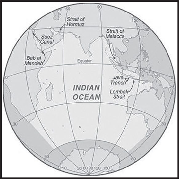
INTRODUCTION
Background: The Indian Ocean is the third largest of the world’s five oceans (after the Pacific Ocean and Atlantic Ocean, but larger than the Southern Ocean and Arctic Ocean). Four critically important access waterways are the Suez Canal (Egypt), Bab el Mandeb (Djibouti-Yemen), Strait of Hormuz (Iran-Oman), and Strait of Malacca (Indonesia-Malaysia). The decision by the International Hydrographic Organization in the spring of 2000 to delimit a fifth ocean, the Southern Ocean, removed the portion of the Indian Ocean south of 60 degrees south latitude.
GEOGRAPHY
Location: body of water between Africa, the Southern Ocean, Asia, and Australia
Geographic coordinates: 20 00 S, 80 00 E
Map references: Political Map of the World
Area: total: 70.56 million sq km
note: includes Andaman Sea, Arabian Sea, Bay of Bengal, Great Australian Bight, Gulf of Aden, Gulf of Oman, Mozambique Channel, Persian Gulf, Red Sea, Savu Sea, Strait of Malacca, Timor Sea, and other tributary water bodies
Area - comparative: almost 7 times the size of the US
Coastline: 66,526 km
Climate: northeast monsoon (December to April), southwest monsoon (June to October); tropical cyclones occur during May/June and October/November in the northern Indian Ocean and January/February in the southern Indian Ocean
Ocean volume:
ocean volume: 264 million cu km
percent of World Ocean total volume: 19.8%
Major ocean currents: the counterclockwise Indian Ocean Gyre comprised of the southward flowing warm Agulhas and East Madagascar Currents in the west, the eastward flowing South Indian Current in the south, the northward flowing cold West Australian Current in the east, and the westward flowing South Equatorial Current in the north; a distinctive annual reversal of surface currents occurs in the northern Indian Ocean; low atmospheric pressure over southwest Asia from hot, rising, summer air results in the southwest monsoon and southwest-to-northeast winds and clockwise currents, while high pressure over northern Asia from cold, falling, winter air results in the northeast monsoon and northeast-to-southwest winds and counterclockwise currents
Elevation: highest point: sea level
lowest point: Java Trench -7,192 m unnamed deep
mean depth: -3,741 m
ocean zones: Composed of water and in a fluid state, the oceans are delimited differently than the solid continents. Oceans are divided into three zones based on depth and light level. Although some sea creatures depend on light to live, others can do without it. Sunlight entering the water may travel about 1,000 m into the oceans under the right conditions, but there is rarely any significant light beyond 200 m.
The upper 200 m (656 ft) of oceans is called the euphotic, or “sunlight,” zone. This zone contains the vast majority of commercial fisheries and is home to many protected marine mammals and sea turtles. Only a small amount of light penetrates beyond this depth.
The zone between 200 m (656 ft) and 1,000 m (3,280 ft) is usually referred to as the “twilight” zone, but is officially the dysphotic zone. In this zone, the intensity of light rapidly dissipates as depth increases. Such a minuscule amount of light penetrates beyond a depth of 200 m that photosynthesis is no longer possible.
The aphotic, or “midnight,” zone exists in depths below 1,000 m (3,280 ft). Sunlight does not penetrate to these depths and the zone is bathed in darkness.
Distance Sunlight Travels in the Ocean: Natural resources oil and gas fields, fish, shrimp, sand and gravel aggregates, placer deposits, polymetallic nodules
Natural hazards: occasional icebergs pose navigational hazard in southern reaches
Geography - note: major chokepoints include Bab el Mandeb, Strait of Hormuz, Strait of Malacca, southern access to the Suez Canal, and the Lombok Strait
ENVIRONMENT
Environment - current issues: marine pollution caused by ocean dumping, waste disposal, and oil spills; deep sea mining; oil pollution in Arabian Sea, Persian Gulf, and Red Sea; coral reefs threatened due to climate change, direct human pressures, and inadequate governance, awareness, and political will; loss of biodiversity; endangered marine species include the dugong, seals, turtles, and whales
Climate: northeast monsoon (December to April), southwest monsoon (June to October); tropical cyclones occur during May/June and October/November in the northern Indian Ocean and January/February in the southern Indian Ocean
Marine fisheries: the Indian Ocean fisheries are the third most important in the world accounting for 15.5%, or 12,220,000 mt of the global catch in 2020; tuna, small pelagic fish, and shrimp are important species in these regions; the Food and Agriculture Organization delineated two fishing regions in the Indian Ocean:
Eastern Indian Ocean region (Region 57) is the most important region and the fifth largest producing region in the world with 8.4%, or 6,590,000 mt, of the global catch in 2020; the region encompasses the waters north of 55° South latitude and east of 80° East longitude including the Bay of Bengal and Andaman Sea with the major producers including India (2,362,481 mt), Indonesia (1,940,558 mt), Burma (1,114,777 mt), Bangladesh (877,837 mt), and Sri Lanka (373,369 mt); the principal catches include shad, Skipjack tuna, mackerel, shrimp, and sardinellas
Western Indian Ocean region (Region 51) is the world’s sixth largest producing region with more than 7.1% or 5,630,000 mt of the global catch in 2020; this region encompasses the waters north of 40° South latitude and west of 80° East longitude including the western Indian Ocean, Arabian Sea, Persian Gulf, and Red Sea as well as the waters along the east coast of Africa and Madagascar, the south coast of the Arabian Peninsula, and the west coast of India with major producers including India (2,207,125 mt), Oman (580,048 mt), Pakistan (341,730 mt), and Mozambique (274,791 mt); the principal catches include Skipjack and Yellowfin tuna, mackerel, sardines, shrimp, and cephalopods
Regional fisheries bodies: Indian Ocean Tuna Commission, Commission for the Conservation of Southern Bluefin Tuna, Regional Commission for Fisheries (Persian Gulf/Gulf of Oman), Southeast Asia Fisheries Development Center, Southwest Indian Ocean Fisheries Commission, South Indian Ocean Fisheries Agreement
GOVERNMENT
Country name: etymology: named for the country of India, which makes up much of its northern border
TRANSPORTATION
Ports and terminals: major seaport(s): Chennai (Madras, India); Colombo (Sri Lanka); Durban (South Africa); Jakarta (Indonesia); Kolkata (Calcutta, India); Melbourne (Australia); Mumbai (Bombay, India); Richards Bay (South Africa)
MILITARY AND SECURITY
Military - note: according to the International Maritime Bureau, areas of high risk for piracy and armed robbery against ships in territorial waters of littoral states and offshore waters include the Gulf of Aden, along the east coast of Africa, the Bay of Bengal, and the Strait of Malacca; in addition, the Maritime Administration of the US Department of Transportation advises that regional conflict, military activity, and political tensions pose threats to commercial vessels in the Persian Gulf, Strait of Hormuz, Gulf of Oman, Arabian Sea, Gulf of Aden, Bab al Mandeb Strait, Red Sea, and Somali Basin (2023)
TRANSNATIONAL ISSUES
Disputes - international: some maritime disputes (see littoral states)
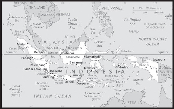
INTRODUCTION
Background: The archipelago was once largely under the control of Buddhist and Hindu rulers. By around the 7th century, a Buddhist kingdom arose on Sumatra and expanded into Java and the Malay Peninsula until it was conquered in the late 13th century by the Hindu Majapahit Empire from Java. Majapahit (1290-1527) united most of modern-day Indonesia and Malaysia. Traders introduced Islam in the trade ports around the 11th century, and Indonesians gradually adopted Islam over the next 500 years. The Portuguese conquered parts of Indonesia in the 16th century, but they were ousted by the Dutch (except in East Timor), who began colonizing the islands in the early 17th century. It would be the early 20th century before Dutch colonial rule was established across the entirety of what would become the boundaries of the modern Indonesian state.
Japan occupied the islands from 1942 to 1945. Indonesia declared its independence shortly before Japan’s surrender, but it required four years of sometimes brutal fighting, intermittent negotiations, and UN mediation before the Netherlands agreed to transfer sovereignty in 1949. A period of sometimes unruly parliamentary democracy ended in 1957 when President SOEKARNO declared martial law and instituted “Guided Democracy.” After an abortive coup in 1965 by alleged communist sympathizers, SOEKARNO was gradually eased from power. From 1967 until 1998, President SUHARTO ruled Indonesia with his “New Order” government. After street protests toppled SUHARTO in 1998, free and fair legislative elections took place in 1999. Indonesia is now the world’s third most populous democracy, the world’s largest archipelagic state, and the world’s largest Muslim-majority nation.
Indonesia faces a number of issues, including alleviating poverty, improving education, preventing terrorism, consolidating democracy after four decades of authoritarianism, implementing economic and financial reforms, stemming corruption, reforming the criminal justice system, addressing climate change, and controlling infectious diseases, particularly those of global and regional importance. In 2005, Indonesia reached a historic peace agreement with armed separatists in Aceh. Indonesia continues to face low intensity armed resistance in Papua by the separatist Free Papua Movement.
GEOGRAPHY
Location: Southeastern Asia, archipelago between the Indian Ocean and the Pacific Ocean
Geographic coordinates: 5 00 S, 120 00 E
Map references: Southeast Asia
Area: total: 1,904,569 sq km
land: 1,811,569 sq km
water: 93,000 sq km
comparison ranking: total 16
Area - comparative: slightly less than three times the size of Texas
Land boundaries: total: 2,958 km
border countries (3): Malaysia 1,881 km; Papua New Guinea 824 km; Timor-Leste 253 km
Coastline: 54,716 km
Maritime claims: territorial sea: 12 nm
exclusive economic zone: 200 nm
measured from claimed archipelagic straight baselines
Climate: tropical; hot, humid; more moderate in highlands
Terrain: mostly coastal lowlands; larger islands have interior mountains
Elevation: highest point: Puncak Jaya 4,884 m
lowest point: Indian Ocean 0 m
mean elevation: 367 m
Natural resources: petroleum, tin, natural gas, nickel, timber, bauxite, copper, fertile soils, coal, gold, silver
note: Indonesia is the World’s leading producer of nickel with an output of 1.6 million mt in 2022
Land use: agricultural land: 31.2% (2018 est.)
arable land: 13% (2018 est.)
permanent crops: 12.1% (2018 est.)
permanent pasture: 6.1% (2018 est.)
forest: 51.7% (2018 est.)
other: 17.1% (2018 est.)
Irrigated land: 67,220 sq km (2012)
Major lakes (area sq km): fresh water lake(s): Danau Toba - 1,150 sq km
note – located in the caldera of a super volcano that erupted more than 70,000 years ago; it is the largest volcanic lake in the World
Major rivers (by length in km): Sepik (shared with Papua New Guinea [s]) - 1,126 km; Fly (shared with Papua New Guinea [s]) - 1,050 km
note – [s] after country name indicates river source; [m] after country name indicates river mouth
Population distribution: major concentration on the island of Java, which is considered one of the most densely populated places on earth; of the outer islands (those surrounding Java and Bali), Sumatra contains some of the most significant clusters, particularly in the south near the Selat Sunda, and along the northeastern coast near Medan; the cities of Makasar (Sulawesi), Banjarmasin (Kalimantan) are also heavily populated
Natural hazards: occasional floods; severe droughts; tsunamis; earthquakes; volcanoes; forest fires
volcanism: Indonesia contains the most volcanoes of any country in the world - some 76 are historically active; significant volcanic activity occurs on Java, Sumatra, the Sunda Islands, Halmahera Island, Sulawesi Island, Sangihe Island, and in the Banda Sea; Merapi (2,968 m), Indonesia’s most active volcano and in eruption since 2010, has been deemed a Decade Volcano by the International Association of Volcanology and Chemistry of the Earth’s Interior, worthy of study due to its explosive history and close proximity to human populations; on 22 December 2018, a large explosion and flank collapse destroyed most of the 338 m high island of Anak Krakatau (Child of Krakatau) and generated a deadly tsunami inundating portions of western Java and southern Sumatra leaving more than 400 dead; other notable historically active volcanoes include Agung, Awu, Karangetang, Krakatau (Krakatoa), Makian, Raung, Sinabung, and Tambora; see note 2 under “Geography - note”
Geography - note: note 1: according to Indonesia’s National Coordinating Agency for Survey and Mapping, the total number of islands in the archipelago is 13,466, of which 922 are permanently inhabited (Indonesia is the world’s largest country comprised solely of islands); the country straddles the equator and occupies a strategic location astride or along major sea lanes from the Indian Ocean to the Pacific Ocean
note 2: Indonesia is one of the countries along the Ring of Fire, a belt of active volcanoes and earthquake epicenters bordering the Pacific Ocean; up to 90% of the world’s earthquakes and some 75% of the world’s volcanoes occur within the Ring of Fire; 80% of tsunamis, caused by volcanic or seismic events, occur within the “Pacific Ring of Fire”
note 3: despite having the fourth largest population in the world, Indonesia is the most heavily forested region on earth after the Amazon
note 4: two major food crops apparently developed on the island of New Guinea: bananas and sugarcane
PEOPLE AND SOCIETY
Population: 279,476,346 (2023 est.)
comparison ranking: 4
Nationality: noun: Indonesian(s)
adjective: Indonesian
Ethnic groups: Javanese 40.1%, Sundanese 15.5%, Malay 3.7%, Batak 3.6%, Madurese 3%, Betawi 2.9%, Minangkabau 2.7%, Buginese 2.7%, Bantenese 2%, Banjarese 1.7%, Balinese 1.7%, Acehnese 1.4%, Dayak 1.4%, Sasak 1.3%, Chinese 1.2%, other 15% (2010 est.)
Languages: Bahasa Indonesia (official, modified form of Malay), English, Dutch, local dialects (of which the most widely spoken is Javanese); note - more than 700 languages are used in Indonesia
major-language sample(s): Fakta Dunia, sumber informasi dasar yang sangat diperlukan. (Indonesian)
Religions: Muslim 87.2%, Protestant 7%, Roman Catholic 2.9%, Hindu 1.7%, other 0.9% (includes Buddhist and Confucian), unspecified 0.4% (2010 est.)
Demographic profile: Indonesia has the world’s fourth-largest population. It is predominantly Muslim and has the largest Muslim population of any country in the world. The population is projected to increase to as much as 320 million by 2045. A government-supported family planning program. The total fertility rate (TFR) – the average number of births per woman – from 5.6 in the mid-1960s to 2.7 in the mid-1990s. The success of the program was also due to the social acceptance of family planning, which received backing from influential Muslim leaders and organizations.
The fertility decline slowed in the late 1990’s when responsibility for family planning programs shifted to the district level, where the programs were not prioritized. Since 2012 the national government revitalized the national family planning program, and Indonesia’s TFR has slowly decreased to 2.3 in 2020. The government may reach its goal of achieving replacement level fertility – 2.1 children per woman – but the large number of women of childbearing age ensures significant population growth for many years.
Indonesia is a source country for labor migrants, a transit country for asylum seekers, and a destination mainly for highly skilled migrant workers. International labor migration, both legal and illegal, from Indonesia to other parts of Asia (most commonly Malaysia) and the Middle East has taken place for decades because of high unemployment and underemployment, poverty, and low wages domestically. Increasing numbers of migrant workers are drawn to Australia, Canada, New Zealand, and the US. The majority of Indonesian labor migration is temporary and consists predominantly of low-skilled workers, mainly women working as domestics.
Indonesia’s strategic location between Asia and Australia and between the Pacific and Indian Oceans – and its relatively easy accessibility via boat – appeal to asylum seekers. It is also an attractive transit location because of its easy entry requirements and the ability to continue on to Australia. Recent asylum seekers have come from Afghanistan, Burma (Rohingyas), Iraq, Somalia, and Sri Lanka. Since 2013, when Australia tightening its immigration policy, thousands of migrants and asylum seekers have been stranded in Indonesia, where they live in precarious conditions and receive only limited support from international organizations. The situation for refugees in Indonesia has also worsened because Australia and the US, which had resettled the majority of refugees in Indonesia, have significantly lowered their intake.
Age structure: 0-14 years: 24.22% (male 34,627,270/female 33,066,304)
15-64 years: 68.1% (male 95,267,122/female 95,063,200)
65 years and over: 7.68% (2023 est.) (male 9,892,325/female 11,560,125)
Dependency ratios: total dependency ratio: 47.6
youth dependency ratio: 37.6
elderly dependency ratio: 10
potential support ratio: 10 (2021 est.)
Median age: total: 31.1 years (2020)
male: 30.5 years
female: 31.8 years
comparison ranking: total 117
Population growth rate: 0.76% (2023 est.)
comparison ranking: 118
Birth rate: 15.05 births/1,000 population (2023 est.)
comparison ranking: 112
Death rate: 6.77 deaths/1,000 population (2023 est.)
comparison ranking: 125
Net migration rate: -0.71 migrant(s)/1,000 population (2023 est.)
comparison ranking: 133
Population distribution: major concentration on the island of Java, which is considered one of the most densely populated places on earth; of the outer islands (those surrounding Java and Bali), Sumatra contains some of the most significant clusters, particularly in the south near the Selat Sunda, and along the northeastern coast near Medan; the cities of Makasar (Sulawesi), Banjarmasin (Kalimantan) are also heavily populated
Urbanization: urban population: 58.6% of total population (2023)
rate of urbanization: 1.99% annual rate of change (2020-25 est.)
Major urban areas - population: 11.249 million JAKARTA (capital), 3.729 million Bekasi, 3.044 million Surabaya, 3.041 million Depok, 2.674 million Bandung, 2.514 million Tangerang (2023)
Sex ratio: at birth: 1.05 male(s)/female
0-14 years: 1.05 male(s)/female
15-64 years: 1 male(s)/female
65 years and over: 0.86 male(s)/female
total population: 1 male(s)/female (2023 est.)
Mother’s mean age at first birth: 22.4 years (2017 est.)
note: data represents median age at first birth among women 25-49
Maternal mortality ratio: 173 deaths/100,000 live births (2020 est.)
comparison ranking: 52
Infant mortality rate: total: 19.31 deaths/1,000 live births (2023 est.)
male: 21.71 deaths/1,000 live births
female: 16.78 deaths/1,000 live births
comparison ranking: total 81
Life expectancy at birth: total population: 73.33 years (2023 est.)
male: 71.1 years
female: 75.68 years
comparison ranking: total population 150
Total fertility rate: 1.99 children born/woman (2023 est.)
comparison ranking: 106
Gross reproduction rate: 0.97 (2023 est.)
Contraceptive prevalence rate: 55.5% (2018)
Drinking water source: improved: urban: 98.2% of population
rural: 86.8% of population
total: 93.3% of population
unimproved: urban: 1.8% of population
rural: 13.2% of population
total: 6.7% of population (2020 est.)
Current health expenditure: 3.4% of GDP (2020)
Physicians density: 0.62 physicians/1,000 population (2020)
Hospital bed density: 1 beds/1,000 population (2017)
Sanitation facility access: improved: urban: 97.2% of population
rural: 86.5% of population
total: 92.5% of population
unimproved: urban: 2.8% of population
rural: 13.5% of population
total: 7.5% of population (2020 est.)
Major infectious diseases: degree of risk: very high (2023)
food or waterborne diseases: bacterial diarrhea, hepatitis A, and typhoid fever
vectorborne diseases: dengue fever and malaria
note: on 31 August 2023, the US Centers for Disease Control and Prevention (CDC) issued a Travel Alert for polio in Southeast Asia; Indonesia is currently considered a high risk to travelers for circulating vaccine-derived polioviruses (cVDPV); vaccine-derived poliovirus (VDPV) is a strain of the weakened poliovirus that was initially included in oral polio vaccine (OPV) and that has changed over time and behaves more like the wild or naturally occurring virus; this means it can be spread more easily to people who are unvaccinated against polio and who come in contact with the stool or respiratory secretions, such as from a sneeze, of an “infected” person who received oral polio vaccine; the CDC recommends that before any international travel, anyone unvaccinated, incompletely vaccinated, or with an unknown polio vaccination status should complete the routine polio vaccine series; before travel to any high-risk destination, the CDC recommends that adults who previously completed the full, routine polio vaccine series receive a single, lifetime booster dose of polio vaccine
Obesity - adult prevalence rate: 6.9% (2016)
comparison ranking: 162
Alcohol consumption per capita: total: 0.08 liters of pure alcohol (2019 est.)
beer: 0.06 liters of pure alcohol (2019 est.)
wine: 0.01 liters of pure alcohol (2019 est.)
spirits: 0.02 liters of pure alcohol (2019 est.)
other alcohols: 0 liters of pure alcohol (2019 est.)
comparison ranking: total 178
Tobacco use: total: 37.6% (2020 est.)
male: 71.4% (2020 est.)
female: 3.7% (2020 est.)
comparison ranking: total 9
Children under the age of 5 years underweight: 17.7% (2018)
comparison ranking: 26
Currently married women (ages 15-49): 70% (2023 est.)
Child marriage: women married by age 15: 2%
women married by age 18: 16.3% (2017 est.)
Education expenditures: 3.5% of GDP (2020 est.)
comparison ranking: 141
Literacy: definition: age 15 and over can read and write
total population: 96%
male: 97.4%
female: 94.6% (2020)
School life expectancy (primary to tertiary education): total: 14 years
male: 14 years
female: 14 years (2018)
Youth unemployment rate (ages 15-24): total: 16.1% (2021 est.)
male: 16.3%
female: 15.7%
comparison ranking: total 107
People - note: Indonesia is the fourth most populous nation in the World after China, India, and the United States; more than half of the Indonesian population - roughly 150 million people or 55% - live on the island of Java (about the size of California) making it the most crowded island on earth
ENVIRONMENT
Environment - current issues: large-scale deforestation (much of it illegal) and related wildfires cause heavy smog; over-exploitation of marine resources; environmental problems associated with rapid urbanization and economic development, including air pollution, traffic congestion, garbage management, and reliable water and waste water services; water pollution from industrial wastes, sewage
Environment - international agreements: party to: Biodiversity, Climate Change, Climate Change-Kyoto Protocol, Climate Change-Paris Agreement, Comprehensive Nuclear Test Ban, Desertification, Endangered Species, Hazardous Wastes, Law of the Sea, Nuclear Test Ban, Ozone Layer Protection, Ship Pollution, Tropical Timber 2006, Wetlands
signed, but not ratified: Marine Life Conservation
Climate: tropical; hot, humid; more moderate in highlands
Land use: agricultural land: 31.2% (2018 est.)
arable land: 13% (2018 est.)
permanent crops: 12.1% (2018 est.)
permanent pasture: 6.1% (2018 est.)
forest: 51.7% (2018 est.)
other: 17.1% (2018 est.)
Urbanization: urban population: 58.6% of total population (2023)
rate of urbanization: 1.99% annual rate of change (2020-25 est.)
Revenue from forest resources: 0.39% of GDP (2018 est.)
comparison ranking: 71
Revenue from coal: 1.06% of GDP (2018 est.)
comparison ranking: 5
Air pollutants: particulate matter emissions: 19.34 micrograms per cubic meter (2019 est.)
carbon dioxide emissions: 563.32 megatons (2016 est.)
methane emissions: 244.5 megatons (2020 est.)
Waste and recycling: municipal solid waste generated annually: 65.2 million tons (2016 est.)
municipal solid waste recycled annually: 4.564 million tons (2016 est.)
percent of municipal solid waste recycled: 7% (2016 est.)
Major lakes (area sq km): fresh water lake(s): Danau Toba - 1,150 sq km
note – located in the caldera of a super volcano that erupted more than 70,000 years ago; it is the largest volcanic lake in the World
Major rivers (by length in km): Sepik (shared with Papua New Guinea [s]) - 1,126 km; Fly (shared with Papua New Guinea [s]) - 1,050 km
note – [s] after country name indicates river source; [m] after country name indicates river mouth
Total water withdrawal: municipal: 23.8 billion cubic meters (2020 est.)
industrial: 9.14 billion cubic meters (2020 est.)
agricultural: 189.7 billion cubic meters (2020 est.)
Total renewable water resources: 2.02 trillion cubic meters (2020 est.)
GOVERNMENT
Country name: conventional long form: Republic of Indonesia
conventional short form: Indonesia
local long form: Republik Indonesia
local short form: Indonesia
former: Netherlands East Indies (Dutch East Indies), Netherlands New Guinea
etymology: the name is an 18th-century construct of two Greek words, “Indos” (India) and “nesoi” (islands), meaning “Indian islands”
Government type: presidential republic
Capital: name: Jakarta; note - Indonesian lawmakers on 18 January 2022 approved the relocation of the country’s capital from Jakarta to a site on the island of Borneo between Samarinda City and the port city of Balikpapan; Nusantara (“archipelago”), the name of the new capital, is expected to be established in August 2024
geographic coordinates: 6 10 S, 106 49 E
time difference: UTC+7 (12 hours ahead of Washington, DC, during Standard Time)
time zone note: Indonesia has three time zones
etymology: “Jakarta” derives from the Sanscrit “Jayakarta” meaning “victorious city” and refers to a successful defeat and expulsion of the Portuguese in 1527; previously the port had been named “Sunda Kelapa”
Administrative divisions: 35 provinces (provinsi-provinsi, singular - provinsi), 1 autonomous province*, 1 special region** (daerah istimewa), and 1 national capital district*** (daerah khusus ibukota); Aceh*, Bali, Banten, Bengkulu, Gorontalo, Jakarta***, Jambi, Jawa Barat (West Java), Jawa Tengah (Central Java), Jawa Timur (East Java), Kalimantan Barat (West Kalimantan), Kalimantan Selatan (South Kalimantan), Kalimantan Tengah (Central Kalimantan), Kalimantan Timur (East Kalimantan), Kalimantan Utara (North Kalimantan), Kepulauan Bangka Belitung (Bangka Belitung Islands), Kepulauan Riau (Riau Islands), Lampung, Maluku, Maluku Utara (North Maluku), Nusa Tenggara Barat (West Nusa Tenggara), Nusa Tenggara Timur (East Nusa Tenggara), Papua, Papua Barat (West Papua), Papua Barat Daya (Southwest Papua), Papua Pegunungan (Papua Highlands), Papua Selatan (South Papua), Papua Tengah (Central Papua), Riau, Sulawesi Barat (West Sulawesi), Sulawesi Selatan (South Sulawesi), Sulawesi Tengah (Central Sulawesi), Sulawesi Tenggara (Southeast Sulawesi), Sulawesi Utara (North Sulawesi), Sumatera Barat (West Sumatra), Sumatera Selatan (South Sumatra), Sumatera Utara (North Sumatra), Yogyakarta**
note: following the implementation of decentralization beginning on 1 January 2001, regencies and municipalities have become the key administrative units responsible for providing most government services
Independence: 17 August 1945 (declared independence from the Netherlands)
National holiday: Independence Day, 17 August (1945)
Constitution: history: drafted July to August 1945, effective 18 August 1945, abrogated by 1949 and 1950 constitutions; 1945 constitution restored 5 July 1959
amendments: proposed by the People’s Consultative Assembly, with at least two thirds of its members present; passage requires simple majority vote by the Assembly membership; constitutional articles on the unitary form of the state cannot be amended; amended several times, last in 2002
Legal system: civil law system based on the Roman-Dutch model and influenced by customary law
International law organization participation: has not submitted an ICJ jurisdiction declaration; non-party state to the ICCt
Citizenship: citizenship by birth: no
citizenship by descent only: at least one parent must be a citizen of Indonesia
dual citizenship recognized: no
residency requirement for naturalization: 5 continuous years
Suffrage: 17 years of age; universal; married persons regardless of age
Executive branch: chief of state: President Joko “Jokowi” WIDODO (since 20 October 2014); Vice President Ma’ruf AMIN (since 20 October 2019); note - the president is both chief of state and head of government
head of government: President Joko “Jokowi” WIDODO (since 20 October 2014); Vice President Ma’ruf AMIN (since 20 October 2019)
cabinet: Cabinet appointed by the president
elections/appointments: president and vice president directly elected by absolute majority popular vote for a 5-year term (eligible for a second term); election last held on 17 April 2019 (next to be held on 14 February 2024)
election results:
2019: Joko WIDODO elected president; percent of vote - Joko WIDODO (PDI-P) 55.5%, PRABOWO Subianto Djojohadikusumo (GERINDRA) 44.5%
2014: Joko WIDODO elected president; percent of vote - Joko WIDODO (PDI-P) 53.15%, PRABOWO Subianto Djojohadikusumo (GERINDRA) 46.85%
Legislative branch: description: bicameral People’s Consultative Assembly or Majelis Permusyawaratan Rakyat consists of:
Regional Representative Council or Dewan Perwakilan Daerah (136 seats; non-partisan members directly elected in multi-seat constituencies - 4 each from the country’s 34 electoral districts - by proportional representation vote to serve 5-year terms); note - the Regional Representative Council has no legislative authority
House of Representatives or Dewan Perwakilan Rakyat (575 seats; members directly elected in multi-seat constituencies by single non-transferable vote to serve 5-year terms)
elections: Regional Representative Council - last held on 17 April 2019 (next to be held in February 2024)
House of Representatives - last held on 17 April 2019 (next to be held in February 2024)
election results: Regional Representative Council - all seats elected on a non-partisan basis; composition - men 102, women 34, percent of women 25%
House of Representatives - percent of vote by party - PDI-P 19.3%, Gerindra 12.6%, Golkar 12.3%, PKB 9.7%, Nasdem 9.1%, PKS 8.2%, PD 7.8%, PAN 6.8%, PPP 4.5%, other 9.6%; seats by party - PDI-P 128, Golkar 85, Gerindra 78, Nasdem 59, PKB 58, PD 54, PKS 50, PAN 44, PPP 19; composition - men 449, women 126, percent of women 21.9%; total People’s Consultative Assembly percent of women 22.5%
Judicial branch: highest court(s): Supreme Court or Mahkamah Agung (51 judges divided into 8 chambers); Constitutional Court or Mahkamah Konstitusi (consists of 9 judges)
judge selection and term of office: Supreme Court judges nominated by Judicial Commission, appointed by president with concurrence of parliament; judges serve until retirement at age 65; Constitutional Court judges - 3 nominated by president, 3 by Supreme Court, and 3 by parliament; judges appointed by the president; judges serve until mandatory retirement at age 70
subordinate courts: High Courts of Appeal, district courts, religious courts
Political parties and leaders: Democrat Party or PD [Agus Harimurti YUDHOYONO]
Functional Groups Party or GOLKAR [Airlangga HARTARTO]
Great Indonesia Movement Party or GERINDRA [PRABOWO Subianto Djojohadikusumo]
Indonesia Democratic Party-Struggle or PDI-P [MEGAWATI Sukarnoputri]
National Awakening Party or PKB [Muhaiman ISKANDAR]
National Democratic Party or NasDem [Surya PALOH]
National Mandate Party or PAN [Zulkifli HASAN]
Prosperous Justice Party or PKS [Ahmad SYAIKHU]
United Development Party or PPP [Muhamad MARDIONO]
note: these parties are those represented in national and regional legislatures; additional parties are represented in only regional legislatures
International organization participation: ADB, APEC, ARF, ASEAN, BIS, CD, CICA (observer), CP, D-8, EAS, EITI (compliant country), FAO, G-11, G-15, G-20, G-77, IAEA, IBRD, ICAO, ICC (national committees), ICRM, IDA, IDB, IFAD, IFC, IFRCS, IHO, ILO, IMF, IMO, IMSO, Interpol, IOC, IOM (observer), IORA, IPU, ISO, ITSO, ITU, ITUC (NGOs), MIGA, MINURSO, MINUSTAH, MONUSCO, MSG (associate member), NAM, OECD (enhanced engagement), OIC, OPCW, PIF (partner), UN, UNAMID, UNCTAD, UNESCO, UNHRC, UNIDO, UNIFIL, UNISFA, UNMIL, UNWTO, UPU, WCO, WFTU (NGOs), WHO, WIPO, WMO, WTO
Diplomatic representation in the US: chief of mission: Ambassador Rosan Perkasa ROESLANI (since 13 January 2022)
chancery: 2020 Massachusetts Avenue NW, Washington, DC 20036
telephone: [1] (202) 775-5200
FAX: [1] (202) 775-5236
email address and website:
https://www.kemlu.go.id/washington/en#!
consulate(s) general: Chicago, Houston, Los Angeles, New York, San Francisco
Diplomatic representation from the US: chief of mission: Ambassador Sung Y. KIM (since 21 October 2020)
embassy: Jl. Medan Merdeka Selatan No. 3-5, Jakarta 10110
mailing address: 8200 Jakarta Place, Washington DC 20521-8200
telephone: [62] (21) 5083-1000
FAX: [62] (21) 385-7189
email address and website:
consulate(s) general: Surabaya
consulate(s): Medan
Flag description: two equal horizontal bands of red (top) and white; the colors derive from the banner of the Majapahit Empire of the 13th-15th centuries; red symbolizes courage, white represents purity
note: similar to the flag of Monaco, which is shorter; also similar to the flag of Poland, which is white (top) and red
National symbol(s): garuda (mythical bird); national colors: red, white
National anthem: name: “Indonesia Raya” (Great Indonesia)
lyrics/music: Wage Rudolf SOEPRATMAN
note: adopted 1945
National heritage: total World Heritage Sites: 10 (6 cultural, 4 natural)
selected World Heritage Site locales: Borobudur Temple Compounds (c); Komodo National Park (n); Prambanan Temple Compounds (c); Ujung Kulon National Park (n); Sangiran Early Man Site (c); Lorentz National Park (n); Tropical Rainforest Heritage of Sumatra (n); Cultural Landscape of Bali Province (c); Ombilin Coal Mining Heritage of Sawahlunto (c); Cosmological Axis of Yogyakarta and its Historic Landmarks (c)
ECONOMY
Economic overview: one of the fastest growing economies and largest in Southeast Asia; upper middle-income country; human capital and competitiveness phase of its 20-year development plan; COVID-19 reversed poverty reduction trajectory; strengthening financial resilience
Real GDP (purchasing power parity): $3.246 trillion (2021 est.)
$3.131 trillion (2020 est.)
$3.197 trillion (2019 est.)
note: data are in 2017 dollars
comparison ranking: 7
Real GDP growth rate: 3.69% (2021 est.)
-2.07% (2020 est.)
5.02% (2019 est.)
comparison ranking: 129
Real GDP per capita: $11,900 (2021 est.)
$11,500 (2020 est.)
$11,900 (2019 est.)
note: data are in 2017 dollars
comparison ranking: 130
GDP (official exchange rate): $1,119,720,000,000 (2019 est.)
Inflation rate (consumer prices): 1.56% (2021 est.)
1.92% (2020 est.)
3.03% (2019 est.)
comparison ranking: 176
Credit ratings: Fitch rating: BBB (2017)
Moody’s rating: Baa2 (2018)
Standard & Poors rating: BBB (2019)
note: The year refers to the year in which the current credit rating was first obtained.
GDP - composition, by sector of origin: agriculture: 13.7% (2017 est.)
industry: 41% (2017 est.)
services: 45.4% (2017 est.)
comparison rankings: services 197; industry 26; agriculture 71
GDP - composition, by end use: household consumption: 57.3% (2017 est.)
government consumption: 9.1% (2017 est.)
investment in fixed capital: 32.1% (2017 est.)
investment in inventories: 0.3% (2017 est.)
exports of goods and services: 20.4% (2017 est.)
imports of goods and services: -19.2% (2017 est.)
Agricultural products: oil palm fruit, rice, maize, sugar cane, coconuts, cassava, bananas, eggs, poultry, rubber
Industries: petroleum and natural gas, textiles, automotive, electrical appliances, apparel, footwear, mining, cement, medical instruments and appliances, handicrafts, chemical fertilizers, plywood, rubber, processed food, jewelry, and tourism
Industrial production growth rate: 3.42% (2021 est.)
comparison ranking: 113
Labor force: 138.119 million (2021 est.)
comparison ranking: 4
Labor force - by occupation: agriculture: 32%
industry: 21%
services: 47% (2016 est.)
Unemployment rate: 4.41% (2021 est.)
4.28% (2020 est.)
3.62% (2019 est.)
comparison ranking: 166
Youth unemployment rate (ages 15-24): total: 16.1% (2021 est.)
male: 16.3%
female: 15.7%
comparison ranking: total 107
Population below poverty line: 9.4% (2019 est.)
Gini Index coefficient - distribution of family income: 37.9 (2021 est.)
comparison ranking: 72
Average household expenditures: on food: 31.7% of household expenditures (2018 est.)
on alcohol and tobacco: 7.2% of household expenditures (2018 est.)
Household income or consumption by percentage share: lowest 10%: 3.4%
highest 10%: 28.2% (2010)
Budget: revenues: $130.872 billion (2020 est.)
expenditures: $192.97 billion (2020 est.)
Budget surplus (+) or deficit (-): -2.7% (of GDP) (2017 est.)
comparison ranking: 122
Public debt: 42.92% of GDP (2020 est.)
33.73% of GDP (2019 est.)
33.14% of GDP (2018 est.)
comparison ranking: 129
Taxes and other revenues: 8.31% (of GDP) (2020 est.)
comparison ranking: 208
Fiscal year: calendar year
Current account balance: $3.459 billion (2021 est.)
-$4.433 billion (2020 est.)
-$30.279 billion (2019 est.)
comparison ranking: 35
Exports: $246.87 billion (2021 est.) note: data are in current year dollars
$178.418 billion (2020 est.) note: data are in current year dollars
$200.097 billion (2019 est.) note: data are in current year dollars
comparison ranking: 32
Exports - partners: China 22%, United States 11%, Japan 8%, India 6%, Singapore 5% (2021)
Exports - commodities: coal, palm oil, natural gas, iron alloys, stainless steel (2021)
Imports: $217.715 billion (2021 est.) note: data are in current year dollars
$159.872 billion (2020 est.) note: data are in current year dollars
$204.23 billion (2019 est.) note: data are in current year dollars
comparison ranking: 31
Imports - partners: China 27%, Singapore 12%, Japan 8%, Thailand 5%, United States 5%, South Korea 5%, Malaysia 5% (2019)
Imports - commodities: refined petroleum, crude petroleum, vehicle parts, telephones, natural gas (2019)
Reserves of foreign exchange and gold: $144.908 billion (31 December 2021 est.)
$135.916 billion (31 December 2020 est.)
$129.186 billion (31 December 2019 est.)
comparison ranking: 22
Debt - external: $393.252 billion (2019 est.)
$360.945 billion (2018 est.)
comparison ranking: 31
Exchange rates: Indonesian rupiah (IDR) per US dollar -
Exchange rates: 14,308.144 (2021 est.)
14,582.203 (2020 est.)
14,147.671 (2019 est.)
14,236.939 (2018 est.)
13,380.834 (2017 est.)
ENERGY
Electricity access: population without electricity: (2020) less than 1 million
electrification - total population: 99.2% (2021)
electrification - urban areas: 99.9% (2021)
electrification - rural areas: 98.2% (2021)
Electricity: installed generating capacity: 69.065 million kW (2020 est.)
consumption: 256,742,190,000 kWh (2019 est.)
exports: 0 kWh (2020 est.)
imports: 1.553 billion kWh (2020 est.)
transmission/distribution losses: 25.08 billion kWh (2019 est.)
comparison rankings: imports 64; exports 151; installed generating capacity 19; transmission/distribution losses 18; consumption 18
Electricity generation sources: fossil fuels: 82.3% of total installed capacity (2020 est.)
wind: 0.2% of total installed capacity (2020 est.)
hydroelectricity: 6.8% of total installed capacity (2020 est.)
geothermal: 5.7% of total installed capacity (2020 est.)
biomass and waste: 5% of total installed capacity (2020 est.)
Coal: production: 563.728 million metric tons (2020 est.)
consumption: 132.548 million metric tons (2020 est.)
exports: 409.892 million metric tons (2020 est.)
imports: 8.95 million metric tons (2020 est.)
proven reserves: 39.891 billion metric tons (2019 est.)
Petroleum: total petroleum production: 842,300 bbl/day (2021 est.)
refined petroleum consumption: 1.649 million bbl/day (2019 est.)
crude oil and lease condensate exports: 204,000 bbl/day (2018 est.)
crude oil and lease condensate imports: 309,700 bbl/day (2018 est.)
crude oil estimated reserves: 2.48 billion barrels (2021 est.)
Refined petroleum products - production: 950,000 bbl/day (2015 est.)
comparison ranking: 18
Refined petroleum products - exports: 79,930 bbl/day (2015 est.)
comparison ranking: 47
Refined petroleum products - imports: 591,500 bbl/day (2015 est.)
comparison ranking: 15
Natural gas: production: 62,612,013,000 cubic meters (2020 est.)
consumption: 38,673,953,000 cubic meters (2020 est.)
exports: 23,938,060,000 cubic meters (2020 est.)
imports: 0 cubic meters (2021 est.)
proven reserves: 1,408,478,000,000 cubic meters (2021 est.)
Carbon dioxide emissions: 563.543 million metric tonnes of CO2 (2019 est.)
from coal and metallurgical coke: 267.326 million metric tonnes of CO2 (2019 est.)
from petroleum and other liquids: 209.279 million metric tonnes of CO2 (2019 est.)
from consumed natural gas: 86.938 million metric tonnes of CO2 (2019 est.)
comparison ranking: total emissions 11
Energy consumption per capita: 29.68 million Btu/person (2019 est.)
comparison ranking: 122
COMMUNICATIONS
Telephones - fixed lines: total subscriptions: 8,998,814 (2021 est.)
subscriptions per 100 inhabitants: 3 (2021 est.)
comparison ranking: total subscriptions 19
Telephones - mobile cellular: total subscriptions: 365,872,608 (2021 est.)
subscriptions per 100 inhabitants: 134 (2021 est.)
comparison ranking: total subscriptions 3
Telecommunication systems: general assessment: Indonesia faces more than the usual number of obstacles in terms of enabling widespread access to quality telecommunications services for its population of more than 270 million; the geographical challenges have been further compounded by a variety of social, political, and economic problems over the years that have kept the country’s wealth distributed very thinly; the fixed-line (fiber) and mobile operators have continued to expand and upgrade their networks across the country; Indonesia’s 18,000 islands (many of which, however, are sparsely populated) makes the deployment of fixed-line infrastructure on a broad scale difficult; there has been renewed activity in fiber optic cable, but the bundling of fixed-line telephony with TV and internet services will see the country’s teledensity stabilize; mobile subscriptions have reached more than 130% and is projected to exceed 150% by 2026; with 4G LTE universally available, the major mobile companies have been busy launching 5G services in selected areas; the rollout of 5G will be hampered by the lack of availability of suitable frequencies; the 4G had to be reallocated from broadcasting services, and indications are that the same process is going to have to be followed in order to allow the expansion of 5G into its core frequency bands (3.3 to 4.2GHz) (2022)
domestic: fixed-line subscribership roughly 3 per 100 and mobile-cellular 134 per 100 persons (2021)
international: country code - 62; landing points for the SEA-ME-WE-3 & 5, DAMAI, JASUKA, BDM, Dumai-Melaka Cable System, IGG, JIBA, Link 1, 3, 4, & 5, PGASCOM, B3J2, Tanjung Pandam-Sungai Kakap Cable System, JAKABARE, JAYABAYA, INDIGO-West, Matrix Cable System, ASC, SJJK, Jaka2LaDeMa, S-U-B Cable System, JBCS, MKCS, BALOK, Palapa Ring East, West and Middle, SMPCS Packet-1 and 2, LTCS, TSCS, SEA-US and Kamal Domestic Submarine Cable System, 35 submarine cable networks that provide links throughout Asia, the Middle East, Australia, Southeast Asia, Africa and Europe; satellite earth stations - 2 Intelsat (1 Indian Ocean and 1 Pacific Ocean) (2019)
Broadcast media: mixture of about a dozen national TV networks - 1 public broadcaster, the remainder private broadcasters - each with multiple transmitters; more than 100 local TV stations; widespread use of satellite and cable TV systems; public radio broadcaster operates 6 national networks, as well as regional and local stations; overall, more than 700 radio stations with more than 650 privately operated (2019)
Internet country code: .id
Internet users: total: 167.4 million (2021 est.)
percent of population: 62% (2021 est.)
comparison ranking: total 5
Broadband - fixed subscriptions: total: 11,722,218 (2020 est.)
subscriptions per 100 inhabitants: 4 (2020 est.)
comparison ranking: total 17
TRANSPORTATION
National air transport system: number of registered air carriers: 25 (2020)
inventory of registered aircraft operated by air carriers: 611
annual passenger traffic on registered air carriers: 115,154,100 (2018)
annual freight traffic on registered air carriers: 1,131,910,000 (2018) mt-km
Civil aircraft registration country code prefix: PK
Airports: 673 (2021)
comparison ranking: total 10
Airports - with paved runways: 186
note: paved runways have a concrete or asphalt surface but not all have facilities for refueling, maintenance, or air traffic control; the length of a runway required for aircraft to safely operate depends on a number of factors including the type of aircraft, the takeoff weight (including passengers, cargo, and fuel), engine types, flap settings, landing speed, elevation of the airport, and average maximum daily air temperature; paved runways can reach a length of 5,000 m (16,000 ft.), but the “typical” length of a commercial airline runway is between 2,500-4,000 m (8,000-13,000 ft.)
Airports - with unpaved runways: 487
note: unpaved runways have a surface composition such as grass or packed earth and are most suited to the operation of light aircraft; unpaved runways are usually short, often less than 1,000 m (3,280 ft.) in length; airports with unpaved runways often lack facilities for refueling, maintenance, or air traffic control
Heliports: 76 (2021)
Pipelines: 1,064 km condensate, 150 km condensate/gas, 11,702 km gas, 119 km liquid petroleum gas, 7,767 km oil, 77 km oil/gas /water, 728 km refined products, 53 km unknown, 44 km water (2013)
Railways: total: 8,159 km (2014)
narrow gauge: 8,159 km (2014) 1.067-m gauge (565 km electrified)
note: 4,816 km operational
comparison ranking: total 27
Roadways: total: 496,607 km (2011)
paved: 283,102 km (2011)
unpaved: 213,505 km (2011)
comparison ranking: total 15
Waterways: 21,579 km (2011)
comparison ranking: 8
Merchant marine: total: 11,015 (2022)
by type: bulk carrier 154, container ship 218, general cargo 2,310, oil tanker 700, other 7,633
comparison ranking: total 1
Ports and terminals: major seaport(s): Banjarmasin, Belawan, Kotabaru, Krueg Geukueh, Palembang, Panjang, Sungai Pakning, Tanjung Perak, Tanjung Priok
container port(s) (TEUs): Tanjung Perak (3,901,215), Tanjung Priok (6,849,227) (2021)
LNG terminal(s) (export): Bontang, Tangguh
LNG terminal(s) (import): Arun, Lampung, West Java
MILITARY AND SECURITY
Military and security forces: Indonesian National Armed Forces (Tentara Nasional Indonesia, TNI): Army (TNI-Angkatan Darat (TNI-AD)), Navy (TNI-Angkatan Laut (TNI-AL); includes Marine Corps (Korps Marinir or KorMar)), Air Force (TNI-Angkatan Udara (TNI-AU)) (2023)
note 1: in 2014, Indonesia created a Maritime Security Agency (Bakamla) to coordinate the actions of all maritime security agencies, including the Navy, the Indonesian Sea and Coast Guard (Kesatuan Penjagaan Laut dan Pantai, KPLP), the Water Police (Polair), Customs (Bea Cukai), and Ministry of Marine Affairs and Fisheries
note 2: the Indonesian National Police, which reports directly to the president, includes a paramilitary Mobile Brigade Corps (BRIMOB); following the Bali terror bombing in 2002, the National Police formed a special counterterrorism force called Detachment 88 (Densus or Detasemen Khusus 88 Antiteror); Detachment 88 often works with the TNI’s Joint Special Operations Command, which has counterterrorism and counterinsurgency units; the National Police are also bolstered by the KAMRA “People’s Security” police auxiliaries
Military expenditures: 0.8% of GDP (2023 est.)
0.8% of GDP (2022 est.)
0.8% of GDP (2021 est.)
0.8% of GDP (2020 est.)
0.8% of GDP (2019 est.)
comparison ranking: 134
Military and security service personnel strengths: approximately 400,000 active-duty troops (300,000 Army; 60,000 Navy, including about 20,000 marines; 30,000 Air Force) (2023)
Military equipment inventories and acquisitions: the military’s inventory is a wide mix of Chinese, Russian, and Western (including US) equipment; in recent years, the top suppliers have included China, France, Germany, the Netherlands, South Korea, and the US; the TNI has been engaged in a modernization program for more than a decade with uneven success; Indonesia has a growing defense industry fueled by technology transfers and cooperation agreements with several countries; in 2019, the Indonesian Government said that growing its domestic defense industry was a national priority over the following 10 years (2023)
Military service age and obligation: 18-45 years of age for voluntary military service for men and women, with selective conscription authorized (men, age 18), but not utilized; 24-month service obligation, with reserve obligation to age 45 (officers) (2023)
note: as of 2023, women comprised about 7% of the Indonesian military
Military deployments: 225 (plus about 140 police) Central African Republic (MINUSCA); 1,025 Democratic Republic of the Congo (MONUSCO); 1,225 Lebanon (UNIFIL) (2023)
Military - note: the military is responsible for external defense, combatting separatism, and responding to natural disasters; in certain conditions it may provide operational support to police, such as for counterterrorism operations, maintaining public order, and addressing communal conflicts; the TNI has undergone reforms since the 1990s to improve its professionalism and limit its involvement in internal politics; the infantry-heavy Army is the largest service and deployed throughout the country in 14 area (KODAM) and three joint area (KOGABWILHAN) defense commands; it also has a special forces command (KOPASSUS) and three strategic reserve (KOSTRAD) infantry division headquarters; as of 2023, the Army was conducting counter-insurgency operations in Papua against the West Papua Liberation Army, the military wing of the Free Papua Organization, which has been fighting a low-level insurgency since Indonesia annexed the former Dutch colony in the 1960s; it has also been assisting police in Sulawesi in countering the Mujahideen Indonesia Timur (MIT; aka East Indonesia Mujahideen), a local militant group affiliated with the Islamic State of Iraq and ash-Sham (ISIS); the Navy is organized and equipped for coastal defense and patrolling Indonesia’s territorial waters where it faces such issues as piracy, transnational crime, illegal fishing, and incursions by Chinese vessels; its warships include more than 30 frigates and corvettes and a substantial number of patrol vessels, plus a handful of attack-type submarines; the Navy also has a maritime aviation component and an amphibious force with several marine infantry brigades and amphibious assault ships; the Air Force has more than 100 combat aircraft
Indonesia is not a formal claimant in the South China Sea, although some of its waters lie within China’s “nine-dash line” maritime claims, resulting in some stand offs in recent years; since 2016, the Indonesian military has bolstered its presence on Great Natuna Island (aka Pulau Natuna Besar), the main island of the Middle Natuna Archipelago, which is part of the Riau Islands Province, and held military exercises in the surrounding waters (2023)
SPACE
Space agency/agencies: National Research and Innovation Agency (BRIN; established 2021); BRIN integrated five previously separate Indonesian institutions, including the National Institute of Aeronautics and Space of Indonesia (Lembaga Penerbangan Dan Antariksa Nasional or LAPAN; established 1964), and nearly 50 governmental research divisions; BRIN is under the Ministry of Research and Technology and manages Indonesia’s space program through the Indonesian Space Agency (INASA; formed 2022) and the Research Organization for Aeronautics and Space (ORPA; formed 2021) (2023)
Space launch site(s): Stasiun Peluncuran Roket rocket launch facility (West Java); building an space launch facility/spaceport on Biak, Papua (estimated completion date is 2025) (2023)
Space program overview: has had a space program since the 1960s that has focused largely on rocket development and the acquisition and operation of satellites; operates satellites; manufactures remote sensing (RS) satellites; has a sounding (research) rocket program geared towards development of an indigenous orbital satellite launch vehicle (SLV) and independent satellite launch capabilities; researching and developing a range of other space-related technologies and capabilities related to satellite payloads, communications, RS, and astronomy; has relations with several foreign space agencies and industries, including those of France, Germany, India, Japan, Russia, and the US (2023)
note: further details about the key activities, programs, and milestones of the country’s space program, as well as government spending estimates on the space sector, appear in Appendix S
TERRORISM
Terrorist group(s): Terrorist group(s): Islamic State of Iraq and ash-Sham (aka Jemaah Anshorut Daulah); Jemaah Islamiyah
note: details about the history, aims, leadership, organization, areas of operation, tactics, targets, weapons, size, and sources of support of the group(s) appear(s) in Appendix-T
TRANSNATIONAL ISSUES
Disputes - international: Indonesia has a stated foreign policy objective of establishing stable fixed land and maritime boundaries with all of its neighbors; three stretches of land borders with Timor-Leste have yet to be delimited, two of which are in the Oecussi exclave area, and no maritime or Exclusive Economic Zone (EEZ) boundaries have been established between the countries; all borders between Indonesia and Australia have been agreed upon bilaterally, but a 1997 treaty that would settle the last of their maritime and EEZ boundary has yet to be ratified by Indonesia’s legislature; Indonesian groups challenge Australia’s claim to Ashmore Reef; Australia has closed parts of the Ashmore and Cartier Reserve to Indonesian traditional fishing and placed restrictions on certain catches; land and maritime negotiations with Malaysia are ongoing, and disputed areas include the controversial Tanjung Datu and Camar Wulan border area in Borneo and the maritime boundary in the Ambalat oil block in the Celebes Sea; Indonesia and Singapore continue to work on finalizing their 1973 maritime boundary agreement by defining unresolved areas north of Indonesia’s Batam Island; Indonesian secessionists, squatters, and illegal migrants create repatriation problems for Papua New Guinea; maritime delimitation talks continue with Palau; EEZ negotiations with Vietnam are ongoing, and the two countries in Fall 2011 agreed to work together to reduce illegal fishing along their maritime boundary
Refugees and internally displaced persons: refugees (country of origin): 5,684 (Afghanistan) (mid-year 2022)
IDPs: 72,000 (inter-communal, inter-faith, and separatist violence between 1998 and 2004 in Aceh and Papua; religious attacks and land conflicts in 2007 and 2013; most IDPs in Aceh, Maluku, East Nusa Tengarra) (2022)
stateless persons: 866 (2022)
Illicit drugs: major transit point and destination for illicit narcotics; a destination for methamphetamine, ecstasy, and other illicit drugs; methamphetamine production facilities within Indonesia
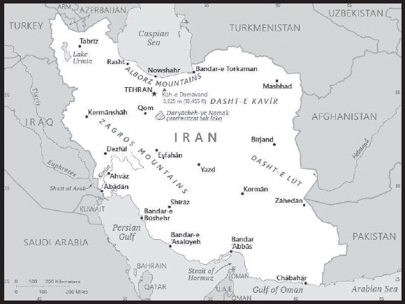
INTRODUCTION
Background: Known as Persia until 1935, Iran became an Islamic republic in 1979 after the ruling monarchy was overthrown and Shah Mohammad Reza PAHLAVI was forced into exile. Conservative clerical forces led by Ayatollah Ruhollah KHOMEINI established a theocratic system of government with ultimate political authority vested in a learned religious scholar referred to commonly as the Supreme Leader who, according to the constitution, is accountable only to the Assembly of Experts - a popularly elected 88-member body of clerics. US-Iranian relations became strained when a group of Iranian students seized the US Embassy in Tehran in November 1979 and held embassy personnel hostage until mid-January 1981. The US cut off diplomatic relations with Iran in April 1980. During the period 1980-88, Iran fought a bloody, indecisive war with Iraq that eventually expanded into the Persian Gulf and led to clashes between US Navy and Iranian military forces. Iran has been designated a state sponsor of terrorism and was subject to US, UN, and EU economic sanctions and export controls because of its continued involvement in terrorism and concerns over possible military dimensions of its nuclear program until Joint Comprehensive Plan of Action (JCPOA) Implementation Day in 2016. The US began gradually re-imposing sanctions on Iran after the Us withdrawal from JCPOA in May 2018.
Following the election of reformer Hojjat ol-Eslam Mohammad KHATAMI as president in 1997 and a reformist Majles (legislature) in 2000, a campaign to foster political reform in response to popular dissatisfaction was initiated. The movement floundered as conservative politicians, supported by the Supreme Leader, unelected institutions of authority like the Guardians Council, and the security services reversed and blocked reform measures while increasing security repression. Starting with nationwide municipal elections in 2003 and continuing through Majles elections in 2004, conservatives reestablished control over Iran’s elected government institutions, which culminated with the August 2005 inauguration of hardliner Mahmud AHMADI-NEJAD as president. His controversial reelection in June 2009 sparked nationwide protests over allegations of electoral fraud, which persisted until early 2011. President AHMADI-NEJAD’s independent streak angered regime establishment figures, including the Supreme Leader, leading to conservative opposition to his agenda for the last year of his presidency, and an alienation of his political supporters. In June 2013, Iranians elected a centrist cleric Dr. Hasan Fereidun RUHANI to the presidency. A longtime senior member in the regime, he made promises of reforming society and Iran’s foreign policy. In July 2015, Iran and the five UNSC permanent members, plus Germany (P5+1) finalized the JCPOA under which Iran agreed to restrictions on its nuclear program in exchange for sanctions relief; however, the US reimposed sanctions in 2018 dealing a blow to RUHANI’s legacy and the Iranian economy. In November 2019, Tehran’s decision to increase the price of gasoline overnight sparked nationwide protests, which the regime violently suppressed within a week. Conservatives won the majority of seats in Iranian Majles elections in elections in February 2020 and hardline cleric Ebrahim RAISI - who had a decades-long career in Iran’s judiciary - was elected president in June 2021, resulting in a hardline and conservative monopoly across the regime’s elected and unelected institutions.
As president, RAISI has concentrated on deepening Iran’s foreign relations with anti-US states - particularly China and Russia - to weather US sanctions and diplomatic pressure, while supporting negotiations to restore a nuclear deal that began in 2021. RAISI contended with nationwide protests that began in September 2022 and persisted for over three months following the death of a Kurdish Iranian woman, Mahsa AMINI, in morality police custody. Young people and women led the protests and in contrast to previous periods of unrest, this latest bout focused on demands for regime change rather than reform within the system or the redressal of economic grievances.
GEOGRAPHY
Location: Middle East, bordering the Gulf of Oman, the Persian Gulf, and the Caspian Sea, between Iraq and Pakistan
Geographic coordinates: 32 00 N, 53 00 E
Map references: Middle East
Area: total: 1,648,195 sq km
land: 1,531,595 sq km
water: 116,600 sq km
comparison ranking: total 19
Area - comparative: almost 2.5 times the size of Texas; slightly smaller than Alaska
Land boundaries: total: 5,894 km
border countries (7): Afghanistan 921 km; Armenia 44 km; Azerbaijan 689 km; Iraq 1,599 km; Pakistan 959 km; Turkey 534 km; Turkmenistan 1,148 km
Coastline: 2,440 km - note: Iran also borders the Caspian Sea (740 km)
Maritime claims: territorial sea: 12 nm
contiguous zone: 24 nm
exclusive economic zone: bilateral agreements or median lines in the Persian Gulf
continental shelf: natural prolongation
Climate: mostly arid or semiarid, subtropical along Caspian coast
Terrain: rugged, mountainous rim; high, central basin with deserts, mountains; small, discontinuous plains along both coasts
Elevation: highest point: Kuh-e Damavand 5,625 m
lowest point: Caspian Sea -28 m
mean elevation: 1,305 m
Natural resources: petroleum, natural gas, coal, chromium, copper, iron ore, lead, manganese, zinc, sulfur
Land use: agricultural land: 30.1% (2018 est.)
arable land: 10.8% (2018 est.)
permanent crops: 1.2% (2018 est.)
permanent pasture: 18.1% (2018 est.)
forest: 6.8% (2018 est.)
other: 63.1% (2018 est.)
Irrigated land: 79,721 sq km (2020)
Major lakes (area sq km): salt water lake(s): Caspian Sea (shared with Russia, Azerbaijan, Turkmenistan, and Kazakhstan) - 374,000 sq km; Lake Urmia - 5,200 sq km; Lake Namak - 750 sq km
Major rivers (by length in km): Euphrates (shared with Turkey [s], Syria, and Iraq [m]) - 3,596 km; Tigris (shared with Turkey, Syria, and Iraq [m]) - 1,950 km; Helmand (shared with Afghanistan [s]) - 1,130 km note - [s] after country name indicates river source; [m] after country name indicates river mouth
Major watersheds (area sq km): Indian Ocean drainage: (Persian Gulf) Tigris and Euphrates (918,044 sq km)
Population distribution: population is concentrated in the north, northwest, and west, reflecting the position of the Zagros and Elburz Mountains; the vast dry areas in the center and eastern parts of the country, around the deserts of the Dasht-e Kavir and Dasht-e Lut, have a much lower population density
Natural hazards: periodic droughts, floods; dust storms, sandstorms; earthquakes
Geography - note: strategic location on the Persian Gulf and Strait of Hormuz, which are vital maritime pathways for crude oil transport
PEOPLE AND SOCIETY
Population: 87,590,873 (2023 est.)
comparison ranking: 17
Nationality: noun: Iranian(s)
adjective: Iranian
Ethnic groups: Persian, Azeri, Kurd, Lur, Baloch, Arab, Turkmen, and Turkic tribes
Languages: Persian Farsi (official), Azeri and other Turkic dialects, Kurdish, Gilaki and Mazandarani, Luri, Balochi, Arabic
major-language sample(s):

(Persian)
Religions: Muslim (official) 99.6% (Shia 90-95%, Sunni 5-10%), other (includes Zoroastrian, Jewish, and Christian) 0.3%, unspecified 0.2% (2016 est.)
Age structure: 0-14 years: 23.51% (male 10,533,573/female 10,060,225)
15-64 years: 69.82% (male 31,140,117/female 30,014,613)
65 years and over: 6.67% (2023 est.) (male 2,723,298/female 3,119,047)
Dependency ratios: total dependency ratio: 45.3
youth dependency ratio: 34.6
elderly dependency ratio: 10.7
potential support ratio: 9.3 (2021 est.)
Median age: total: 31.7 years (2020)
male: 31.5 years
female: 32 years
comparison ranking: total 113
Population growth rate: 0.93% (2023 est.)
comparison ranking: 98
Birth rate: 14.79 births/1,000 population (2023 est.)
comparison ranking: 116
Death rate: 5.2 deaths/1,000 population (2023 est.)
comparison ranking: 187
Net migration rate: -0.3 migrant(s)/1,000 population (2023 est.)
comparison ranking: 120
Population distribution: population is concentrated in the north, northwest, and west, reflecting the position of the Zagros and Elburz Mountains; the vast dry areas in the center and eastern parts of the country, around the deserts of the Dasht-e Kavir and Dasht-e Lut, have a much lower population density
Urbanization: urban population: 77.3% of total population (2023)
rate of urbanization: 1.32% annual rate of change (2020-25 est.)
Major urban areas - population: 9.500 million TEHRAN (capital), 3.368 million Mashhad, 2.258 million Esfahan, 1.721 million Shiraz, 1.661 million Tabriz, 1.594 million Karaj (2023)
Sex ratio: at birth: 1.05 male(s)/female
0-14 years: 1.05 male(s)/female
15-64 years: 1.04 male(s)/female
65 years and over: 0.87 male(s)/female
total population: 1.03 male(s)/female (2023 est.)
Maternal mortality ratio: 22 deaths/100,000 live births (2020 est.)
comparison ranking: 119
Infant mortality rate: total: 14.58 deaths/1,000 live births (2023 est.)
male: 15.7 deaths/1,000 live births
female: 13.4 deaths/1,000 live births
comparison ranking: total 100
Life expectancy at birth: total population: 75.44 years (2023 est.)
male: 74.07 years
female: 76.87 years
comparison ranking: total population 127
Total fertility rate: 1.92 children born/woman (2023 est.)
comparison ranking: 118
Gross reproduction rate: 0.94 (2023 est.)
Drinking water source: improved: urban: 99.8% of population
rural: 98.1% of population
total: 99.4% of population
unimproved: urban: 0.2% of population
rural: 1.9% of population
total: 0.6% of population (2020 est.)
Current health expenditure: 5.3% of GDP (2020)
Physicians density: 1.58 physicians/1,000 population (2018)
Hospital bed density: 1.6 beds/1,000 population (2017)
Sanitation facility access: improved:
total: 100% of population
unimproved: total: 0% of population (2020 est.)
Major infectious diseases: degree of risk: intermediate (2023)
food or waterborne diseases: bacterial diarrhea
vectorborne diseases: Crimean-Congo hemorrhagic fever
Obesity - adult prevalence rate: 25.8% (2016)
comparison ranking: 47
Alcohol consumption per capita: total: 0.02 liters of pure alcohol (2019 est.)
beer: 0 liters of pure alcohol (2019 est.)
wine: 0 liters of pure alcohol (2019 est.)
spirits: 0.02 liters of pure alcohol (2019 est.)
other alcohols: 0 liters of pure alcohol (2019 est.)
comparison ranking: total 181
Tobacco use: total: 13.6% (2020 est.)
male: 24.1% (2020 est.)
female: 3.1% (2020 est.)
comparison ranking: total 113
Children under the age of 5 years underweight: 4.3% (2017)
comparison ranking: 78
Currently married women (ages 15-49): 70.3% (2023 est.)
Education expenditures: 3.6% of GDP (2020 est.)
comparison ranking: 137
Literacy: definition: age 15 and over can read and write
total population: 88.7%
male: 92.4%
female: 88.7% (2021)
School life expectancy (primary to tertiary education): total: 15 years
male: 15 years
female: 15 years (2020)
Youth unemployment rate (ages 15-24): total: 27.2% (2021 est.)
male: 24%
female: 41.7%
comparison ranking: total 51
ENVIRONMENT
Environment - current issues: air pollution, especially in urban areas, from vehicle emissions, refinery operations, and industrial effluents; deforestation; overgrazing; desertification; oil pollution in the Persian Gulf; wetland losses from drought; soil degradation (salination); inadequate supplies of potable water; water pollution from raw sewage and industrial waste; urbanization
Environment - international agreements: party to: Biodiversity, Climate Change, Climate Change-Kyoto Protocol, Desertification, Endangered Species, Hazardous Wastes, Marine Dumping-London Convention, Marine Dumping-London Protocol, Nuclear Test Ban, Ozone Layer Protection, Ship Pollution, Wetlands
signed, but not ratified: Climate Change-Paris Agreement, Comprehensive Nuclear Test Ban, Environmental Modification, Law of the Sea, Marine Life Conservation
Climate: mostly arid or semiarid, subtropical along Caspian coast
Land use: agricultural land: 30.1% (2018 est.)
arable land: 10.8% (2018 est.)
permanent crops: 1.2% (2018 est.)
permanent pasture: 18.1% (2018 est.)
forest: 6.8% (2018 est.)
other: 63.1% (2018 est.)
Urbanization: urban population: 77.3% of total population (2023)
rate of urbanization: 1.32% annual rate of change (2020-25 est.)
Revenue from forest resources: 0.01% of GDP (2017 est.)
comparison ranking: 152
Revenue from coal: 0.01% of GDP (2017 est.)
comparison ranking: 47
Air pollutants: particulate matter emissions: 31.62 micrograms per cubic meter (2019 est.)
carbon dioxide emissions: 661.71 megatons (2016 est.)
methane emissions: 158.71 megatons (2020 est.)
Waste and recycling: municipal solid waste generated annually: 17.885 million tons (2017 est.)
municipal solid waste recycled annually: 894,250 tons (2017 est.)
percent of municipal solid waste recycled: 5% (2017 est.)
Major lakes (area sq km): salt water lake(s): Caspian Sea (shared with Russia, Azerbaijan, Turkmenistan, and Kazakhstan) - 374,000 sq km; Lake Urmia - 5,200 sq km; Lake Namak - 750 sq km
Major rivers (by length in km): Euphrates (shared with Turkey [s], Syria, and Iraq [m]) - 3,596 km; Tigris (shared with Turkey, Syria, and Iraq [m]) - 1,950 km; Helmand (shared with Afghanistan [s]) - 1,130 km
note – [s] after country name indicates river source; [m] after country name indicates river mouth
Major watersheds (area sq km): Indian Ocean drainage: (Persian Gulf) Tigris and Euphrates (918,044 sq km)
Total water withdrawal: municipal: 6.2 billion cubic meters (2020 est.)
industrial: 1.1 billion cubic meters (2020 est.)
agricultural: 86 billion cubic meters (2020 est.)
Total renewable water resources: 137.05 billion cubic meters (2020 est.)
GOVERNMENT
Country name: conventional long form: Islamic Republic of Iran
conventional short form: Iran
local long form: Jomhuri-ye Eslami-ye Iran
local short form: Iran
former: Persia
etymology: name derives from the Avestan term “aryanam” meaning “Land of the Noble [Ones]”
Government type: theocratic republic
Capital: name: Tehran
geographic coordinates: 35 42 N, 51 25 E
time difference: UTC+3.5 (8.5 hours ahead of Washington, DC, during Standard Time)
daylight saving time: +1hr, begins fourth Wednesday in March; ends fourth Friday in September
etymology: various explanations of the city’s name have been proffered, but the most plausible states that it derives from the Persian words tah meaning “end or bottom” and ran meaning “[mountain] slope” to signify “bottom of the mountain slope”; Tehran lies at the bottom slope of the Elburz Mountains
Administrative divisions: 31 provinces (ostanha, singular - ostan); Alborz, Ardabil, Azarbayjan-e Gharbi (West Azerbaijan), Azarbayjan-e Sharqi (East Azerbaijan), Bushehr, Chahar Mahal va Bakhtiari, Esfahan, Fars, Gilan, Golestan, Hamadan, Hormozgan, Ilam, Kerman, Kermanshah, Khorasan-e Jonubi (South Khorasan), Khorasan-e Razavi (Razavi Khorasan), Khorasan-e Shomali (North Khorasan), Khuzestan, Kohgiluyeh va Bowyer Ahmad, Kordestan, Lorestan, Markazi, Mazandaran, Qazvin, Qom, Semnan, Sistan va Baluchestan, Tehran, Yazd, Zanjan
Independence: 1 April 1979 (Islamic Republic of Iran proclaimed); notable earlier dates: ca. 550 B.C. (Achaemenid (Persian) Empire established); A.D. 1501 (Iran reunified under the Safavid Dynasty); 1794 (beginning of Qajar Dynasty); 12 December 1925 (modern Iran established under the PAHLAVI Dynasty)
National holiday: Republic Day, 1 April (1979)
Constitution: history: previous 1906; latest adopted 24 October 1979, effective 3 December 1979
amendments: proposed by the supreme leader – after consultation with the Exigency Council – and submitted as an edict to the “Council for Revision of the Constitution,” a body consisting of various executive, legislative, judicial, and academic leaders and members; passage requires absolute majority vote in a referendum and approval of the supreme leader; articles including Iran’s political system, its religious basis, and its form of government cannot be amended; amended 1989
Legal system: religious legal system based on secular and Islamic law
International law organization participation: has not submitted an ICJ jurisdiction declaration; non-party state to the ICCt
Citizenship: citizenship by birth: no
citizenship by descent only: the father must be a citizen of Iran
dual citizenship recognized: no
residency requirement for naturalization: 5 years
Suffrage: 18 years of age; universal
Executive branch: chief of state: Supreme Leader Ali Hoseini-KHAMENEI (since 4 June 1989)
head of government: President Ebrahim RAISI (since 18 June 2021); First Vice President Mohammad MOKHBER (since 8 August 2021)
cabinet: Council of Ministers selected by the president with legislative approval; the supreme leader has some control over appointments to several ministries
elections/appointments: supreme leader appointed for life by Assembly of Experts; president directly elected by absolute majority popular vote in 2 rounds if needed for a 4-year term (eligible for a second term and an additional nonconsecutive term); election last held on 18 June 2021 (next to be held in June 2025)
election results:
2021: Ebrahim RAISI elected president; percent of vote - Ebrahim RAISI (independent) 72.4%, Mohsen REZAI (RFII) 13.8%, Abbdolnaser HEMATI (ECP) 9.8%, Amir-Hosein Qazizadeh-HASHEMI (Islamic Law Party) 4%
2017: Hasan Fereidun RUHANI reelected president; percent of vote - Hasan Fereidun RUHANI (Moderation and Development Party) 58.8%, Ebrahim RAISI (Combat Clergy Association) 39.4%, Mostafa Mir-SALIM Islamic Coalition Party) 1.2%, Mostafa HASHEMI-TABA (Executives of Construction Party) 0.5%
Legislative branch: description: unicameral Islamic Consultative Assembly or Majles-e Shura-ye Eslami or Majles (290 seats; 285 members directly elected in single- and multi-seat constituencies by 2-round vote, and 1 seat each for Zoroastrians, Jews, Assyrian and Chaldean Christians, Armenians in the north of the country and Armenians in the south; members serve 4-year terms); note - all candidates to the Majles must be approved by the Council of Guardians, a 12-member group of which 6 are appointed by the supreme leader and 6 are jurists nominated by the judiciary and elected by the Majles
elections: first round held on 21 February 2020 and second round for 11 remaining seats held on 11 September 2020 (next full Majles election to be held in 2024)
election results: percent of vote by coalition (first round) - NA; seats by coalition (first round) - conservatives and hardliners 226, reformists 19, independents 40, religious minorities 5; as of June 2021 by-elections; composition - men 274, women 16, percent of women 5.6%
Judicial branch: highest court(s): Supreme Court (consists of the chief justice and organized into 42 two-bench branches, each with a justice and a judge)
judge selection and term of office: Supreme Court president appointed by the head of the High Judicial Council (HJC), a 5-member body to include the Supreme Court chief justice, the prosecutor general, and 3 clergy, in consultation with judges of the Supreme Court; president appointed for a single, renewable 5-year term; other judges appointed by the HJC; judge tenure NA
subordinate courts: Penal Courts I and II; Islamic Revolutionary Courts; Courts of Peace; Special Clerical Court (functions outside the judicial system and handles cases involving clerics); military courts
Political parties and leaders: Combatant Clergy Association [Mostafa PURMOHAMMADI] (an active political group)
Executives of Construction Party [Hossein MARASHI]
Front of Islamic Revolutionary Stability [Sadegh MAHSULI, secretary general]
Islamic Coalition Party [Asadollah BADAMCHIAN]
Militant Clerics Society (Majma-e Ruhaniyoun-e Mobarez) or MRM [Mohammad Mousavi KHOEINIHA]
Moderation and Development Party [Hassan RUHANI]
National Trust Party (Hezb-e E’temad-eMelli) or HEM [Elias HAZRATI]
Progress and Justice Society [Mohammad Saeed AHADIAN]
Union of Islamic Iran People’s Party (Hezb-e Ettehad-e Iran-e Eslami) [Azar MANSURI]
International organization participation: CICA, CP, D-8, ECO, FAO, G-15, G-24, G-77, IAEA, IBRD, ICAO, ICC (national committees), ICRM, IDA, IDB, IFAD, IFC, IFRCS, IHO, ILO, IMF, IMO, IMSO, Interpol, IOC, IOM, IPU, ISO, ITSO, ITU, MIGA, NAM, OIC, OPCW, OPEC, PCA, SAARC (observer), SCO (observer), UN, UNAMID, UNCTAD, UNESCO, UNHCR, UNIDO, UNITAR, UNWTO, UPU, WCO, WFTU (NGOs), WHO, WIPO, WMO, WTO (observer)
Diplomatic representation in the US: chief of mission: none; Iran has an Interests Section in the Pakistani Embassy; address: Iranian Interests Section, Embassy of Pakistan, 1250 23rd Street NW, Washington, DC 20037; telephone: [1] (202) 965-4990; FAX [1] (202) 965-1073; email: requests@daftar.org; info@daftarwashington.com; website: https://daftar.org/
Diplomatic representation from the US: embassy: none; the US Interests Section is located in the Embassy of Switzerland; US Foreign Interests Section, Embassy of Switzerland, Pasdaran, Shahid Mousavi Street (Golestan 5th), Corner of Paydarfard Street, No. 55, Tehran
Flag description: three equal horizontal bands of green (top), white, and red; the national emblem (a stylized representation of the word Allah in the shape of a tulip, a symbol of martyrdom) in red is centered in the white band; ALLAH AKBAR (God is Great) in white Arabic script is repeated 11 times along the bottom edge of the green band and 11 times along the top edge of the red band; green is the color of Islam and also represents growth, white symbolizes honesty and peace, red stands for bravery and martyrdom
National symbol(s): lion; national colors: green, white, red
National anthem: name: “Soroud-e Melli-ye Jomhouri-ye Eslami-ye Iran” (National Anthem of the Islamic Republic of Iran)
lyrics/music: multiple authors/Hassan RIAHI
note 1: adopted 1990; Iran has had six national anthems; the first, entitled “Salam-e Shah” (Royal Salute) was in use from 1873-1909; next came “Salamati-ye Dowlat-e Elliye-ye Iran” (Salute of the Sublime State of Persia, 1909-1933); it was followed by “Sorud-e melli” (The Imperial Anthem of Iran; 1933-1979), which chronicled the exploits of the Pahlavi Dynasty; “Ey Iran” (Oh Iran) functioned unofficially as the national anthem for a brief period between the ouster of the Shah in 1979 and the early days of the Islamic Republic in 1980; “Payandeh Bada Iran” (Long Live Iran) was used between 1980 and 1990 during the time of Ayatollah KHOMEINI
note 2: a recording of the current Iranian national anthem is unavailable since the US Navy Band does not record anthems for countries from which the US does not anticipate official visits; the US does not have diplomatic relations with Iran
National heritage: total World Heritage Sites: 27 (25 cultural, 2 natural)
selected World Heritage Site locales: Persepolis (c); Tchogha Zanbil (c); Bam and its Cultural Landscape (c); Golestan Palace (c); Shushtar Historical Hydraulic System (c); Pasargadae (c); Hyrcanian Forests (n); Tabriz Historic Bazaar Complex (c); Meidan Emam, Esfahan (c); Bisotun (c)
ECONOMY
Economic overview: traditionally state-controlled economy but reforming state-owned financial entities; strong oil/gas, agricultural, and service sectors; recent massive inflation due to exchange rate depreciation, international sanctions, and investor uncertainty; increasing poverty
Real GDP (purchasing power parity): $1.319 trillion (2021 est.)
$1.26 trillion (2020 est.)
$1.219 trillion (2019 est.)
note: data are in 2017 dollars
comparison ranking: 18
Real GDP growth rate: 4.72% (2021 est.)
3.33% (2020 est.)
-2.66% (2019 est.)
comparison ranking: 97
Real GDP per capita: $15,000 (2021 est.)
$14,400 (2020 est.)
$14,100 (2019 est.)
note: data are in 2017 dollars
comparison ranking: 106
GDP (official exchange rate): $581.252 billion (2019 est.)
Inflation rate (consumer prices): 43.39% (2021 est.)
30.59% (2020 est.)
39.91% (2019 est.)
note: official Iranian estimate
comparison ranking: 6
GDP - composition, by sector of origin: agriculture: 9.6% (2016 est.)
industry: 35.3% (2016 est.)
services: 55% (2017 est.)
comparison rankings: services 154; industry 45; agriculture 92
GDP - composition, by end use: household consumption: 49.7% (2017 est.)
government consumption: 14% (2017 est.)
investment in fixed capital: 20.6% (2017 est.)
investment in inventories: 14.5% (2017 est.)
exports of goods and services: 26% (2017 est.)
imports of goods and services: -24.9% (2017 est.)
Agricultural products: wheat, sugar cane, milk, sugar beet, tomatoes, barley, potatoes, oranges, poultry, apples
Industries: petroleum, petrochemicals, gas, fertilizer, caustic soda, textiles, cement and other construction materials, food processing (particularly sugar refining and vegetable oil production), ferrous and nonferrous metal fabrication, armaments
Industrial production growth rate: 3.21% (2021 est.)
comparison ranking: 121
Labor force: 27.682 million (2021 est.)
note: shortage of skilled labor
comparison ranking: 24
Labor force - by occupation: agriculture: 16.3%
industry: 35.1%
services: 48.6% (2013 est.)
Unemployment rate: 11.46% (2021 est.)
12.17% (2020 est.)
10.74% (2019 est.)
note: data are Iranian Government numbers
comparison ranking: 60
Youth unemployment rate (ages 15-24): total: 27.2% (2021 est.)
male: 24%
female: 41.7%
comparison ranking: total 51
Population below poverty line: 18.7% (2007 est.)
Gini Index coefficient - distribution of family income: 40.9 (2019 est.)
comparison ranking: 50
Average household expenditures: on food: 27.9% of household expenditures (2018 est.)
on alcohol and tobacco: 0.6% of household expenditures (2018 est.)
Household income or consumption by percentage share: lowest 10%: 2.6%
highest 10%: 29.6% (2005)
Budget: revenues: $60.714 billion (2019 est.)
expenditures: $90.238 billion (2019 est.)
Budget surplus (+) or deficit (-): -2.3% (of GDP) (2017 est.)
comparison ranking: 109
Public debt: 39.5% of GDP (2017 est.)
47.5% of GDP (2016 est.)
note: includes publicly guaranteed debt
comparison ranking: 137
Taxes and other revenues: 17.3% (of GDP) (2017 est.)
comparison ranking: 116
Fiscal year: 21 March - 20 March
Current account balance: $9.491 billion (2017 est.)
$16.28 billion (2016 est.)
comparison ranking: 27
Exports: $101.4 billion (2017 est.)
$83.98 billion (2016 est.)
comparison ranking: 45
Exports - partners: China 48%, India 12%, South Korea 8%, Turkey 6%, United Arab Emirates 5% (2019)
Exports - commodities: ethylene polymers, pistachios, iron, copper, industrial alcohols, aluminum (2021)
Imports: $76.39 billion (2017 est.)
$63.14 billion (2016 est.)
comparison ranking: 52
Imports - partners: China 28%, United Arab Emirates 20%, India 11%, Turkey 7%, Brazil 6%, Germany 5% (2019)
Imports - commodities: rice, corn, broadcasting equipment, soybean products, beef (2019)
Reserves of foreign exchange and gold: $120.6 billion (31 December 2017 est.)
$133.7 billion (31 December 2016 est.)
comparison ranking: 24
Debt - external: $7.995 billion (31 December 2017 est.)
$8.196 billion (31 December 2016 est.)
comparison ranking: 121
Exchange rates: Iranian rials (IRR) per US dollar -
Exchange rates: 42,000 (2021 est.)
42,000 (2020 est.)
42,000 (2019 est.)
40,864.329 (2018 est.)
33,226.298 (2017 est.)
ENERGY
Electricity access: electrification - total population: 100% (2021)
Electricity: installed generating capacity: 80.553 million kW (2020 est.)
consumption: 279,826,390,000 kWh (2019 est.)
exports: 6.365 billion kWh (2019 est.)
imports: 2.738 billion kWh (2019 est.)
transmission/distribution losses: 34.303 billion kWh (2019 est.)
comparison rankings: installed generating capacity 17; transmission/distribution losses 10; imports 54; exports 29; consumption 14
Electricity generation sources: fossil fuels: 88.7% of total installed capacity (2020 est.)
nuclear: 1.9% of total installed capacity (2020 est.)
solar: 0.1% of total installed capacity (2020 est.)
wind: 0.2% of total installed capacity (2020 est.)
hydroelectricity: 9.1% of total installed capacity (2020 est.)
tide and wave: 0% of total installed capacity (2020 est.)
geothermal: 0% of total installed capacity (2020 est.)
biomass and waste: 0% of total installed capacity (2020 est.)
Nuclear energy: Number of operational nuclear reactors: 1 (2023)
Number of nuclear reactors under construction: 1
Net capacity of operational nuclear reactors: 0.92GW (2023)
Percent of total electricity production: 0.1% (2021)
Percent of total energy produced: 0.19% (2021)
Number of nuclear reactors permanently shut down: 0
Coal: production: 2.783 million metric tons (2020 est.)
consumption: 2.794 million metric tons (2020 est.)
exports: 76,000 metric tons (2020 est.)
imports: 87,000 metric tons (2020 est.)
proven reserves: 1.203 billion metric tons (2019 est.)
Petroleum: total petroleum production: 3,450,300 bbl/day (2021 est.)
refined petroleum consumption: 1.934 million bbl/day (2019 est.)
crude oil and lease condensate exports: 2,230,900 bbl/day (2018 est.)
crude oil and lease condensate imports: 33,500 bbl/day (2018 est.)
crude oil estimated reserves: 208.6 billion barrels (2021 est.)
Refined petroleum products - production: 1.764 million bbl/day (2015 est.)
comparison ranking: 11
Refined petroleum products - exports: 397,200 bbl/day (2015 est.)
comparison ranking: 21
Refined petroleum products - imports: 64,160 bbl/day (2015 est.)
comparison ranking: 72
Natural gas: production: 237,561,415,000 cubic meters (2019 est.)
consumption: 220,704,282,000 cubic meters (2019 est.)
exports: 17,607,046,000 cubic meters (2019 est.)
imports: 1,153,457,000 cubic meters (2019 est.)
proven reserves: 33,987,296,000,000 cubic meters (2021 est.)
Carbon dioxide emissions: 646.038 million metric tonnes of CO2 (2019 est.)
from coal and metallurgical coke: 5.142 million metric tonnes of CO2 (2019 est.)
from petroleum and other liquids: 204.21 million metric tonnes of CO2 (2019 est.)
from consumed natural gas: 436.687 million metric tonnes of CO2 (2019 est.)
comparison ranking: total emissions 8
Energy consumption per capita: 145.54 million Btu/person (2019 est.)
comparison ranking: 36
COMMUNICATIONS
Telephones - fixed lines: total subscriptions: 29,306,782 (2021 est.)
subscriptions per 100 inhabitants: 33 (2021 est.)
comparison ranking: total subscriptions 7
Telephones - mobile cellular: total subscriptions: 135,899,424 (2021 est.)
subscriptions per 100 inhabitants: 155 (2021 est.)
comparison ranking: total subscriptions 13
Telecommunication systems: general assessment: Iran’s telecom infrastructure has suffered from sanctions in recent years, which prevented the import of equipment and devices and encouraged widespread smuggling, with a consequent loss of tax revenue; to address this, the government introduced a device registration scheme, and bolstered the capacity for domestically manufactured mobile phones; companies have invested in broadening the reach of their LTE networks, which has increased network capacity and improved the quality of mobile broadband services; the country is also looking to 5G; the sector is still limited by low frequency bands; the government is addressing this with plans to reallocate the 3.5GHz band for 5G use; Iran is keen to grow its digital economy; Iran offers significant opportunities for growth in the telecoms sector; the country has one of the largest populations in the Middle East, and there is a high proportion of youthful, tech savvy users having considerable demand for both fixed and mobile telecom services; companies are offering national roaming to improve services in rural areas (2022)
domestic: approximately 33 per 100 for fixed-line and 155 per 100 for mobile-cellular subscriptions (2021)
international: country code - 98; landing points for Kuwait-Iran, GBICS & MENA, FALCON, OMRAN/3PEG Cable System, POI and UAE-Iran submarine fiber-optic cable to the Middle East, Africa and India; (TAE) fiber-optic line runs from Azerbaijan through the northern portion of Iran to Turkmenistan with expansion to Georgia and Azerbaijan; HF radio and microwave radio relay to Turkey, Azerbaijan, Pakistan, Afghanistan, Turkmenistan, Syria, Kuwait, Tajikistan, and Uzbekistan; satellite earth stations - 13 (9 Intelsat and 4 Inmarsat) (2019)
Broadcast media: state-run broadcast media with no private, independent broadcasters; Islamic Republic of Iran Broadcasting (IRIB), the state-run TV broadcaster, operates more than 60 television channels, more than 50 radio stations, and dozens of newspapers and websites; about 20 foreign Persian-language TV stations broadcasting on satellite TV are capable of being seen in Iran; satellite dishes are illegal and, while their use is subjectively tolerated, authorities confiscate satellite dishes from time to time; most major international broadcasters transmit to Iran (2023)
Internet country code: .ir
Internet users: total: 69.52 million (2021 est.)
percent of population: 79% (2021 est.)
comparison ranking: total 13
Broadband - fixed subscriptions: total: 9,564,195 (2020 est.)
subscriptions per 100 inhabitants: 11 (2020 est.)
comparison ranking: total 21
TRANSPORTATION
National air transport system: number of registered air carriers: 22 (2020)
inventory of registered aircraft operated by air carriers: 237
annual passenger traffic on registered air carriers: 25,604,871 (2018)
annual freight traffic on registered air carriers: 290.74 million (2018) mt-km
Civil aircraft registration country code prefix: EP
Airports: 319 (2021)
comparison ranking: total 22
Airports - with paved runways: 140
note: paved runways have a concrete or asphalt surface but not all have facilities for refueling, maintenance, or air traffic control; the length of a runway required for aircraft to safely operate depends on a number of factors including the type of aircraft, the takeoff weight (including passengers, cargo, and fuel), engine types, flap settings, landing speed, elevation of the airport, and average maximum daily air temperature; paved runways can reach a length of 5,000 m (16,000 ft.), but the “typical” length of a commercial airline runway is between 2,500-4,000 m (8,000-13,000 ft.)
Airports - with unpaved runways: 179
note: unpaved runways have a surface composition such as grass or packed earth and are most suited to the operation of light aircraft; unpaved runways are usually short, often less than 1,000 m (3,280 ft.) in length; airports with unpaved runways often lack facilities for refueling, maintenance, or air traffic control
Heliports: 26 (2021)
Pipelines: 7 km condensate, 973 km condensate/gas, 20,794 km gas, 570 km liquid petroleum gas, 8,625 km oil, 7,937 km refined products (2013)
Railways: total: 8,483.5 km (2014)
standard gauge: 8,389.5 km (2014) 1.435-m gauge (189.5 km electrified)
broad gauge: 94 km (2014) 1.676-m gauge
comparison ranking: total 25
Roadways: total: 223,485 km (2018)
paved: 195,485 km (2018)
unpaved: 28,000 km (2018)
comparison ranking: total 23
Waterways: 850 km (2012) (on Karun River; some navigation on Lake Urmia)
comparison ranking: 76
Merchant marine: total: 942 (2022)
by type: bulk carrier 32, container ship 31, general cargo 393, oil tanker 83, other 403
comparison ranking: total 25
Ports and terminals: major seaport(s): Bandar-e Asaluyeh, Bandar Abbas, Bandar-e Emam Khomeyni
container port(s) (TEUs): Bandar Abbas
MILITARY AND SECURITY
Military and security forces: the military forces of Iran are divided between the Islamic Republic of Iran Regular Forces (Artesh) and the Islamic Revolutionary Guard Corps (Sepah); Islamic Republic of Iran Regular Forces or Islamic Republic of Iran Army (Artesh): Ground Forces, Navy (includes marines), Air Force, Air Defense Forces; Islamic Revolutionary Guard Corps (IRGC or Sepah): Ground Forces, Navy (includes marines), Aerospace Force (controls strategic missile force), Qods Force (aka Quds Force; special operations), Cyber Electronic Command, Basij Paramilitary Forces
Ministry of Interior: Law Enforcement Command
Ministry of Intelligence and Security (2023)
note 1: the Artesh Navy operates Iran’s larger warships and operates in the Gulf of Oman, the Caspian Sea, and deep waters in the region and beyond; the IRGC Navy has responsibility for the closer-in waters of the Persian Gulf and Strait of Hormuz
note 2: the Basij is a volunteer paramilitary group under the IRGC with local organizations across the country, which sometimes acts as an auxiliary law enforcement unit for the IRGC; it is formally known as the Organization for the Mobilization of the Oppressed; it is also known as the Popular Mobilization Army
note 3: the Ministry of Intelligence and Security and law enforcement forces under the Interior Ministry, which report to the president, and the IRGC, which reports to the supreme leader, share responsibility for law enforcement and maintaining order
note 4: the Law Enforcement Command (FARAJA) is the uniformed police of Iran and includes branches for public security, traffic control, anti-narcotics, special forces (riot control, counterterrorism, hostage rescue, etc), intelligence, and criminal investigations; it has responsibility for border security (Border Guard Command)
Military expenditures: 2.5% of GDP (2022 est.)
2.3% of GDP (2021 est.)
2.1% of GDP (2020 est.)
2.5% of GDP (2019 est.)
3.4% of GDP (2018 est.)
comparison ranking: 42
Military and security service personnel strengths: information varies; up to 600,000 active armed forces personnel; approximately 400,000 Islamic Republic of Iran Regular Forces (350,000 Ground Forces; 18,000 Navy; 40,000 Air Force/Air Defense Forces); approximately 150-190,000 Islamic Revolutionary Guard Corps (100-150,000 Ground Forces; 20,000 Navy; 15,000 Aerospace Force; 5-15,000 Qods Force); estimated 90,000 active Basij Paramilitary Forces (2023)
Military equipment inventories and acquisitions: the Iranian military’s inventory includes a mix of domestically produced and mostly older foreign equipment largely of Chinese, Russian, Soviet, and US origin (US equipment acquired prior to the Islamic Revolution in 1979); it also has some military equipment from North Korea, including midget submarines and ballistic missiles; in recent years, Iran has received some newer equipment from Russia; Iran has a defense industry with the capacity to develop, produce, support, and sustain air, land, missile, and naval weapons programs (2023)
Military service age and obligation: military service is compulsory for all Iranian men 18/19 to approximately age 40; 16 for voluntary military service (may be as low as 15 for the Basij); conscript military service obligation is 18-24 months, depending on the location of service (soldiers serving in places of high security risk and deprived areas serve shorter terms); women exempted from military service (2023)
note: conscripts serve in the Artesh, IRGC, and Law Enforcement; approximately 80% of Artesh ground forces personnel are conscripts, while Navy and Air/Air Defense Force personnel are primarily volunteers; conscripts reportedly comprise more than 50% of the IRGC
Military deployments: continues to maintain a military presence in Syria reportedly of a few thousand personnel, mostly of special operations and IRGC forces (2023)
note: Iran has recruited, trained, and funded thousands of Syrian and foreign fighters to support the ASAD regime during the Syrian civil war
Military - note: the Islamic Revolutionary Guard Corps (IRGC) was formed in May 1979 in the immediate aftermath of Shah Mohammad Reza PAHLAVI’s fall, as leftists, nationalists, and Islamists jockeyed for power; while the interim prime minister controlled the government and state institutions, such as the Army, followers of Ayatollah Ruhollah KHOMEINI organized counterweights, including the IRGC, to protect the Islamic revolution; the IRGC’s command structure bypassed the elected president and went directly to KHOMEINI; the IRGC played a critical role in helping KHOMEINI consolidate power in the aftermath of the 1979 revolution, and it ensured that KHOMEINI’s Islamic revolutionary vision prevailed against domestic challenges from nationalists and leftist factions in the scramble for control after the Shah’s departure; the Iran-Iraq War (1980–88) transformed the IRGC into more of a conventional fighting force with its own ground, air, naval, and special forces, plus control over Iran’s strategic missile and rocket forces; today, the IRGC is a highly institutionalized and parallel military force to Iran’s regular armed forces (Artesh); it is heavily involved in internal security and has significant influence in the political and economic spheres of Iranian society, as well as Iran’s foreign policy; on the economic front, it owns factories and corporations and subsidiaries in banking, infrastructure, housing, airlines, tourism and other sectors; its special operations forces, known as the Qods/Quds Force, specialize in foreign missions and have provided advice, funding, guidance, material support, training, and weapons to militants in countries such as Afghanistan, Iraq, Syria, and Yemen, as well as extremist groups, including HAMAS, Hizballah, Kata’ib Hizballah, and Palestine Islamic Jihad (see Appendix T for additional details on the IRGC and Qods Force); the Qods Force also conducts intelligence and reconnaissance operations
the Supreme Council for National Security (SCNS) is the senior-most body for formulating Iran’s foreign and security policy; it is formally chaired by the president, who also appoints the SCNS secretary; its members include the speaker of the Majles, the head of the judiciary, the chief of the Armed Forces General Staff (chief of defense or CHOD), the commanders of the Artesh (regular forces) and IRGC, and the ministers of defense, foreign affairs, interior, and intelligence; the SCNS reports to the supreme leader; the supreme leader is the commander-in-chief of the armed forces
the Iranian Armed Forces are divided between the regular forces (Artesh) and the IRGC; the Artesh primarily focuses on defending Iran’s borders and territorial waters from external threats, while the IRGC has a broader mission to defend the Iranian revolution from any foreign or domestic threat; in 1989, Iran established the Armed Forces General Staff to coordinate military action across both the Artesh and the IRGC; Iran also has a joint military headquarters, the Khatam ol-Anbia Central Headquarters, to command the Artesh and IRGC in wartime
the Artesh Ground Force consists of about 50 combat brigades, mostly infantry with a sizable contingent of airborne, armored, commando, mechanized, and special operations forces; most units are concentrated along the Iran-Iraq border, reflecting the force’s primary mission to defend against foreign invasion; the IRGC Ground Force is organized into 31 provincial corps and a Tehran city corps, which are postured to counter internal unrest and a ground invasion; the corps have a broad mix of armored, infantry, mechanized, and commando units; the IRGC’s special operations forces are known as the Qods Force; the IRGC controls the Basij Paramilitary Forces, which are also organized into provincial corps with mobile/rapid-reaction, security, infantry, and commando battalions
the Artesh Navy is considered Iran’s “blue water” navy and has the primary mission of defending Iranian territorial waters and protecting the country’s economic interests in the Caspian Sea, Gulf of Oman, and beyond; it has approximately 10 frigates and corvettes, plus a small force of attack and midget submarines (note - Iran is the only Persian Gulf nation with a submarine force); the IRGC Navy is tasked with protecting primarily the Iranian littoral waters in the Persian Gulf and Strait of Hormuz and employs a force of mostly small, fast attack vessels armed with a variety of weapons systems including anti-ship missiles
Iran’s air and air defense capabilities are split primarily across three services: the Islamic Republic of Iran Air Force (IRIAF) and the Islamic Republic of Iran Air Defense Force (IRIADF), both under the Artesh, and the IRGC Aerospace Force (IRGCASF); the IRIAF operates the majority of Iran’s combat aircraft and has more than 200 such aircraft, a considerable portion of which are older US models acquired before the 1979 revolution; the remainder includes older Chinese-, French-, and Russian-produced aircraft; the IRIADF controls the country’s surface-to-air missile capabilities; the IRGCASF operates some ground attack aircraft and most of Iran’s unmanned aerial vehicles; it also controls Iran’s cruise and ballistic missile force (2023)
SPACE
Space agency/agencies: Iranian Space Agency (ISA; created in 2003 from merging the activities of the Iranian Remote Sensing Center and some of the activities of the Telecommunications Company of Iran); Iran Space Research Center (established, 2000); Ministry of Defense and Armed Forces Logistics; Aerospace Industries Organization (AIO; under the Ministry of Defense); Islamic Revolutionary Guard Corps (IRGC) Space Command (formed in 2020) (2023)
Space launch site(s): Imam Khomeini Space Center (aka Semnan Space Center; Semnan province); Shahroud Space Center (IGRC military base; Semnan Province); Qom Space Center (Qom Province); inaugurated its first space monitoring center located near Delijan (Markazi Province) in 2013 (2023)
Space program overview: has an ambitious civil and military space program focused on acquiring and operating satellites and developing indigenous satellite/space launch vehicles (SLV); designs, builds, and operates satellites, including communications, remote sensing (RS), and scientific; manufactures and operates SLVs; researching and developing other space-related capabilities and technologies in such areas as telecommunications, RS, navigation, and space situational awareness; UN Security Council and other international sanctions against Iran’s weapons of mass destruction program have severely limited Iran’s cooperation with foreign space agencies and commercial space industries; in recent years, however, it has cooperated with North Korea and Russia on space issues; Iran has also had relations with regional and international space organizations, such as the Asia-Pacific Space Cooperation Organization and the International Telecommunications Satellite Organization; it was a founding member of the UN Committee on the Peaceful Uses of Outer Space (COPUOS) established in 1958 (2023)
note: further details about the key activities, programs, and milestones of the country’s space program, as well as government spending estimates on the space sector, appear in Appendix S
TERRORISM
Terrorist group(s): Terrorist group(s): Islamic Revolutionary Guard Corps (IRGC)/Qods Force; Islamic State of Iraq and ash-Sham (ISIS); Jaysh al Adl (Jundallah); Kurdistan Workers’ Party (PKK); al-Qa’ida
note: details about the history, aims, leadership, organization, areas of operation, tactics, targets, weapons, size, and sources of support of the group(s) appear(s) in Appendix-T
TRANSNATIONAL ISSUES
Disputes - international: Iran-Afghanistan: Iran protests Afghanistan’s limiting flow of dammed Helmand River tributaries during drought; Afghan and Iranian commissioners have discussed boundary monument densification and resurvey
Iran-Azerbaijan-Kazakhstan-Russia: Azerbaijan, Kazakhstan, and Russia ratified a Caspian seabed delimitation treaty in 2018 based on equidistance, while Iran continues to insist on a one-fifth slice of the sea
Iran-Iraq: Iraq’s lack of a maritime boundary with Iran prompts jurisdiction disputes beyond the mouth of the Shatt al Arab in the Persian Gulf
Iran-UAE: Iran and UAE dispute Tunb Islands and Abu Musa Island, which are occupied by Iran; the dispute was rehashed at the September 2021 UN General Assembly meeting; Iran’s Islamic Revolution Guards Corp opened an airport on Greater Tunb in February 2022
Refugees and internally displaced persons: refugees (country of origin): 500,000 undocumented Afghans, 750,000 Afghan refugee card holders, 12,000 Iraqi refugee card holders (2022)
stateless persons: 34 (mid-year 2021)
Trafficking in persons: tier rating: Tier 3 — Iran does not fully meet the minimum standards for the elimination of trafficking and is not making significant efforts to do so; therefore, Iran remained in Tier 3; the government took some steps to address trafficking, including forming an anti-trafficking committee to develop strategies and programs to combat trafficking; however, the government continued a policy of recruiting and using child soldiers and coercing adults to fight for Iranian-led militias in Syria; officials continued to perpetrate and condone trafficking crimes; authorities failed to identify and protect trafficking victims among vulnerable populations and continued to treat trafficking victims as criminals; victims continued to face severe punishment or death for unlawful acts traffickers compelled them to commit (2022)
trafficking profile: human traffickers exploit domestic and foreign victims in Iran, and Iranians are exploited abroad; the continuing decline of the Iranian economy has significantly exacerbated human trafficking, particularly for vulnerable and marginalized groups such as ethnic minorities, refugee and migrants, women, and children; women and girls, as well as some men, are highly vulnerable to sex trafficking in Iran; Iranian and Afghan boys and girls are forced into prostitution domestically; Iranian women, boys, and girls are vulnerable to sex trafficking in Afghanistan, Armenia, Georgia, Iraq, Pakistan, Turkey, and the United Arab Emirates; Iranian and Afghan refugee and migrant children, orphans, and homeless children increasingly are vulnerable to forced labor in Iran; criminal groups reportedly play a significant role in human trafficking in Iran, including kidnaping or purchasing Iranian and migrant children for forced labor and sexual exploitation; Afghan refugees and migrants, as well as Pakistani migrants, are vulnerable to abuse and labor exploitation (2022)
Illicit drugs: significant transit and destination country for opiates and cannabis products mainly from Afghanistan and Pakistan; produces and consumes methamphetamine and traffics it to international markets; one of the primary transshipment routes for Southwest Asian heroin to Europe; opium and cannabis most widely used drugs domestically along with increase in crystal methamphetamine