K
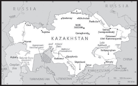
INTRODUCTION
Background: Ethnic Kazakhs derive from a mix of Turkic nomadic tribes that migrated to the region in the 15th century. The Kazakh steppe was conquered by the Russian Empire in the 18th and 19th centuries, and Kazakhstan became a Soviet Republic in 1925. Repression and starvation caused by forced agricultural collectivization led to more than a million deaths in the early 1930s. During the 1950s and 1960s, the agricultural “Virgin Lands” program led to an influx of settlers (mostly ethnic Russians, but also other nationalities) and at the time of Kazakhstan’s independence in 1991, ethnic Kazakhs were a minority. Non-Muslim ethnic minorities departed Kazakhstan in large numbers from the mid-1990s through the mid-2000s and a national program has repatriated about a million ethnic Kazakhs (from Uzbekistan, Tajikistan, Mongolia, and the Xinjiang region of China) back to Kazakhstan. As a result of this shift, the ethnic Kazakh share of the population now exceeds two-thirds.
Kazakhstan’s economy is the largest in Central Asia, mainly due to the country’s vast natural resources. Current issues include: diversifying the economy, attracting foreign direct investment, enhancing Kazakhstan’s economic competitiveness, and strengthening economic relations with neighboring states and foreign powers.
GEOGRAPHY
Location: Central Asia, northwest of China; a small portion west of the Ural (Oral) River in easternmost Europe
Geographic coordinates: 48 00 N, 68 00 E
Map references: Asia
Area: total: 2,724,900 sq km
land: 2,699,700 sq km
water: 25,200 sq km
comparison ranking: total 10
Area - comparative: slightly less than four times the size of Texas
Land boundaries: total: 13,364 km
border countries (5): China 1,765 km; Kyrgyzstan 1,212 km; Russia 7,644 km; Turkmenistan 413 km; Uzbekistan 2,330 km
Coastline: 0 km (landlocked); note - Kazakhstan borders the Aral Sea, now split into two bodies of water (1,070 km), and the Caspian Sea (1,894 km)
Maritime claims: none (landlocked)
Climate: continental, cold winters and hot summers, arid and semiarid
Terrain: vast flat steppe extending from the Volga in the west to the Altai Mountains in the east and from the plains of western Siberia in the north to oases and deserts of Central Asia in the south
Elevation: highest point: Pik Khan-Tengri 7,010 m
note - the northern most 7,000 meter peak in the World
lowest point: Qauyndy Oyysy -132 m
mean elevation: 387 m
Natural resources: major deposits of petroleum, natural gas, coal, iron ore, manganese, chrome ore, nickel, cobalt, copper, molybdenum, lead, zinc, bauxite, gold, uranium
Land use: agricultural land: 77.4% (2018 est.)
arable land: 8.9% (2018 est.)
permanent crops: 0% (2018 est.)
permanent pasture: 68.5% (2018 est.)
forest: 1.2% (2018 est.)
other: 21.4% (2018 est.)
Irrigated land: 18,099 sq km (2020)
Major lakes (area sq km): fresh water lake(s): Ozero Balkhash - 22,000 sq km; Ozero Zaysan - 1,800 sq km
salt water lake(s): Caspian Sea (shared with Iran, Azerbaijan, Turkmenistan, and Russia) - 374,000 sq km; Aral Sea (north) - 3,300 sq km; Ozero Alakol - 2,650 sq km; Ozero Teniz 1,590 sq km; Ozero Seletytenzi - 780 sq km; Ozero Sasykkol - 740 sq km
Major rivers (by length in km): Syr Darya river mouth (shared with Kyrgyzstan [s], Uzbekistan, and Tajikistan) - 3,078 km
note – [s] after country name indicates river source; [m] after country name indicates river mouth
Major watersheds (area sq km): Internal (endorheic basin) drainage: Tarim Basin (1,152,448 sq km), Amu Darya (534,739 sq km), Syr Darya (782,617 sq km), Lake Balkash (510,015 sq km)
Population distribution: most of the country displays a low population density, particularly the interior; population clusters appear in urban agglomerations in the far northern and southern portions of the country
Natural hazards: earthquakes in the south; mudslides around Almaty
Geography - note: World’s largest landlocked country and one of only two landlocked countries in the world that extends into two continents (the other is Azerbaijan); Russia leases approximately 6,000 sq km of territory enclosing the Baikonur Cosmodrome; in January 2004, Kazakhstan and Russia extended the lease to 2050
PEOPLE AND SOCIETY
Population: 19,543,464 (2023 est.)
comparison ranking: 64
Nationality: noun: Kazakhstani(s)
adjective: Kazakhstani
Ethnic groups: Kazakh (Qazaq) 69.6%, Russian 17.9%, Uzbek 3.3%, Uyghur 1.5%, Ukrainian 1.3%, Tatar 1%, other 5.3% (2022 est.)
Languages: Kazakh (official, Qazaq) 83.1% (understand spoken language) and trilingual (Kazakh, Russian, English) 22.3% (2017 est.); Russian (official, used in everyday business, designated the “language of interethnic communication”) 94.4% (understand spoken language) (2009 est.)
major-language sample(s):

(Kazakh)

(Russian)
Religions: Muslim 70.2%, Christian 26.2% (mainly Russian Orthodox), other 0.2%, atheist 2.8%, unspecified 0.5% (2009 est.)
Demographic profile: Nearly 40% of Kazakhstan’s population is under the age of 25. Like many former Soviet states, Kazakhstan’s total fertility rate (TFR) – the average number of births per woman – decreased after independence amidst economic problems and fell below replacement level, 2.1. However, in the late 2000s, as the economy improved and incomes rose, Kazakhstan experienced a small baby boom and TFR reached 2.5. TFR has since fallen and is now just over 2.1. Mortality rates are also decreasing and life expectancy is rising, signs that Kazakhstan’s demographic transition is progressing.
Kazakhstan has a diverse population consisting of Asian ethnic groups (predominantly Kazakhs, as well as Uzbeks, Uighurs, and Tatars) and ethnic Europeans (mainly Russians but also Ukrainians and Germans). Approximately two thirds of Kazakhstan’s population today is Kazakh. During the mid-20th century, as Kazakhstan industrialized, waves of ethnic Russians and deportees from other parts of the Soviet Union arrived. Eventually, the ethnic Russian population outnumbered the Kazakhs. In the 1990s, following Kazakhstan’s independence, Russian and other ethnic Europeans began emigrating, while some ethnic Kazakhs (referred to as Oralmans) returned to their homeland from neighboring countries, China, and Mongolia. As a result, the country’s ethnic make-up changed, and a Kazakh majority was reestablished.
In recent years, Kazakhstan has shifted from being mainly a migrant-sending country to a migrant-receiving country. Due to its oil- driven economic boom, Kazakhstan has become a more popular destination. The country needs highly skilled workers in the industrial, business, and education sectors and low-skilled labor in agriculture, markets, services, and construction. Kazakhstan is increasingly reliant on migrant workers, primarily from Kyrgyzstan, Tajikistan, and Uzbekistan, to fill its labor shortage. At the same time, highly skilled Kazakhs continue to emigrate, mostly to Russia, seeking higher salaries or further education.
Age structure: 0-14 years: 25.26% (male 2386022/female 2,551,575)
15-64 years: 65.29% (male 6,226,792/female 6,533,887)
65 years and over: 9.44% (2023 est.) (male 660,397/female 1,184,791)
Dependency ratios: total dependency ratio: 60
youth dependency ratio: 47.2
elderly dependency ratio: 12.7
potential support ratio: 7.9 (2021 est.)
Median age: total: 31.6 years (2020)
male: 30.3 years
female: 32.8 years
comparison ranking: total 114
Population growth rate: 0.73% (2023 est.)
comparison ranking: 123
Birth rate: 14.92 births/1,000 population (2023 est.)
comparison ranking: 115
Death rate: 8.05 deaths/1,000 population (2023 est.)
comparison ranking: 86
Net migration rate: 0.39 migrant(s)/1,000 population (2023 est.)
comparison ranking: 73
Population distribution: most of the country displays a low population density, particularly the interior; population clusters appear in urban agglomerations in the far northern and southern portions of the country
Urbanization: urban population: 58.2% of total population (2023)
rate of urbanization: 1.19% annual rate of change (2020-25 est.)
Major urban areas - population: 1.987 million Almaty, 1.291 million NUR-SULTAN (capital), 1.155 million Shimkent (2023)
Sex ratio: at birth: 0.94 male(s)/female
0-14 years: 0.94 male(s)/female
15-64 years: 0.95 male(s)/female
65 years and over: 0.56 male(s)/female
total population: 0.9 male(s)/female (2023 est.)
Mother’s mean age at first birth: 28.9 years (2019 est.)
Maternal mortality ratio: 13 deaths/100,000 live births (2020 est.)
comparison ranking: 139
Infant mortality rate: total: 18.77 deaths/1,000 live births (2023 est.)
male: 21.29 deaths/1,000 live births
female: 16.41 deaths/1,000 live births
comparison ranking: total 85
Life expectancy at birth: total population: 72.8 years (2023 est.)
male: 67.73 years
female: 77.56 years
comparison ranking: total population 154
Total fertility rate: 2.08 children born/woman (2023 est.)
comparison ranking: 94
Gross reproduction rate: 1.08 (2023 est.)
Contraceptive prevalence rate: 53% (2018)
note: percent of women aged 18-49
Drinking water source: improved: urban: 100% of population
rural: 93.8% of population
total: 97.4% of population
unimproved: urban: 0% of population
rural: 6.2% of population
total: 2.6% of population (2020 est.)
Current health expenditure: 3.8% of GDP (2020)
Physicians density: 3.98 physicians/1,000 population (2020)
Hospital bed density: 6.1 beds/1,000 population (2014)
Sanitation facility access: improved:
total: 99.9% of population
unimproved:
total: 0.1% of population (2020 est.)
Obesity - adult prevalence rate: 21% (2016)
comparison ranking: 94
Alcohol consumption per capita: total: 3.73 liters of pure alcohol (2019 est.)
beer: 2.52 liters of pure alcohol (2019 est.)
wine: 0.16 liters of pure alcohol (2019 est.)
spirits: 1.05 liters of pure alcohol (2019 est.)
other alcohols: 0 liters of pure alcohol (2019 est.)
comparison ranking: total 100
Tobacco use: total: 23.2% (2020 est.)
male: 39.6% (2020 est.)
female: 6.7% (2020 est.)
comparison ranking: total 63
Children under the age of 5 years underweight: 2% (2015)
comparison ranking: 105
Currently married women (ages 15-49): 61.8% (2023 est.)
Education expenditures: 4.5% of GDP (2020 est.)
comparison ranking: 97
Literacy: definition: age 15 and over can read and write
total population: 99.8%
male: 99.8%
female: 99.7% (2018)
School life expectancy (primary to tertiary education): total: 16 years
male: 15 years
female: 16 years (2020)
Youth unemployment rate (ages 15-24): total: 3.7% (2021 est.)
male: 3.3%
female: 4.3%
comparison ranking: total 194
ENVIRONMENT
Environment - current issues: radioactive or toxic chemical sites associated with former defense industries and test ranges scattered throughout the country pose health risks for humans and animals; industrial pollution is severe in some cities; because the two main rivers that flowed into the Aral Sea have been diverted for irrigation, it is drying up and leaving behind a harmful layer of chemical pesticides and natural salts; these substances are then picked up by the wind and blown into noxious dust storms; pollution in the Caspian Sea; desertification; soil pollution from overuse of agricultural chemicals and salination from poor infrastructure and wasteful irrigation practices
Environment - international agreements: party to: Air Pollution, Antarctic Treaty, Biodiversity, Climate Change, Climate Change-Kyoto Protocol, Climate Change-Paris Agreement, Comprehensive Nuclear Test Ban, Desertification, Endangered Species, Environmental Modification, Hazardous Wastes, Ozone Layer Protection, Ship Pollution, Wetlands
signed, but not ratified: none of the selected agreements
Climate: continental, cold winters and hot summers, arid and semiarid
Land use: agricultural land: 77.4% (2018 est.)
arable land: 8.9% (2018 est.)
permanent crops: 0% (2018 est.)
permanent pasture: 68.5% (2018 est.)
forest: 1.2% (2018 est.)
other: 21.4% (2018 est.)
Urbanization: urban population: 58.2% of total population (2023)
rate of urbanization: 1.19% annual rate of change (2020-25 est.)
Revenue from forest resources: 0% of GDP (2018 est.)
comparison ranking: 162
Revenue from coal: 0.99% of GDP (2018 est.)
comparison ranking: 6
Air pollutants: particulate matter emissions: 26.5 micrograms per cubic meter (2019 est.)
carbon dioxide emissions: 247.21 megatons (2016 est.)
methane emissions: 45.03 megatons (2020 est.)
Waste and recycling: municipal solid waste generated annually: 4,659,740 tons (2012 est.)
municipal solid waste recycled annually: 136,064 tons (2012 est.)
percent of municipal solid waste recycled: 2.9% (2012 est.)
Major lakes (area sq km): fresh water lake(s): Ozero Balkhash - 22,000 sq km; Ozero Zaysan - 1,800 sq km
salt water lake(s): Caspian Sea (shared with Iran, Azerbaijan, Turkmenistan, and Russia) - 374,000 sq km; Aral Sea (north) - 3,300 sq km; Ozero Alakol - 2,650 sq km; Ozero Teniz 1,590 sq km; Ozero Seletytenzi - 780 sq km; Ozero Sasykkol - 740 sq km
Major rivers (by length in km): Syr Darya river mouth (shared with Kyrgyzstan [s], Uzbekistan, and Tajikistan) - 3,078 km
note – [s] after country name indicates river source; [m] after country name indicates river mouth
Major watersheds (area sq km): Internal (endorheic basin) drainage: Tarim Basin (1,152,448 sq km), Amu Darya (534,739 sq km), Syr Darya (782,617 sq km), Lake Balkash (510,015 sq km)
Total water withdrawal: municipal: 4.62 billion cubic meters (2020 est.)
industrial: 4.54 billion cubic meters (2020 est.)
agricultural: 15.4 billion cubic meters (2020 est.)
Total renewable water resources: 108.41 billion cubic meters (2020 est.)
GOVERNMENT
Country name: conventional long form: Republic of Kazakhstan
conventional short form: Kazakhstan
local long form: Qazaqstan Respublikasy
local short form: Qazaqstan
former: Kazakh Soviet Socialist Republic
etymology: the name “Kazakh” may derive from the Turkic word “kaz” meaning “to wander,” recalling the Kazakh’s nomadic lifestyle; the Persian suffix “-stan” means “place of” or “country,” so the word Kazakhstan literally means “Land of the Wanderers”
Government type: presidential republic
Capital: name: Astana
geographic coordinates: 51 10 N, 71 25 E
time difference: UTC+6 (11 hours ahead of Washington, DC, during Standard Time)
time zone note: Kazakhstan has two time zones
etymology: the name means “capital city” in Kazakh
note: on 17 September 2022, Kazakhstan changed the name of its capital city from Nur-Sultan back to Astana; this was not the first time the city had its name changed; founded in 1830 as Akmoly, it became Akmolinsk in 1832, Tselinograd in 1961, Akmola (Aqmola) in 1992, Astana in 1998, and Nur-Sultan in 2019; the latest name change occurred just three and a half years after the city was renamed to honor a long-serving (28-year) former president, who subsequently fell out of favor
Administrative divisions: 17 provinces (oblystar, singular - oblys) and 4 cities* (qalalar, singular - qala); Abay (Semey), Almaty (Qonaev), Almaty*, Aqmola (Kokshetau), Aqtobe, Astana*, Atyrau, Batys Qazaqstan [West Kazakhstan] (Oral), Bayqongyr*, Mangghystau (Aqtau), Pavlodar, Qaraghandy, Qostanay, Qyzylorda, Shyghys Qazaqstan [East Kazakhstan] (Oskemen), Shymkent*, Soltustik Qazaqstan [North Kazakhstan] (Petropavl), Turkistan, Ulytau (Zhezqazghan), Zhambyl (Taraz), Zhetisu (Taldyqorghan)
note: administrative divisions have the same names as their administrative centers (exceptions have the administrative center name following in parentheses); in 1995, the Governments of Kazakhstan and Russia entered into an agreement whereby Russia would lease for a period of 20 years an area of 6,000 sq km enclosing the Baikonur space launch facilities and the city of Bayqongyr (Baikonur, formerly Leninsk); in 2004, a new agreement extended the lease to 2050
Independence: 16 December 1991 (from the Soviet Union)
National holiday: Independence Day, 16 December (1991)
Constitution: history: previous 1937, 1978 (preindependence), 1993; latest approved by referendum 30 August 1995, effective 5 September 1995
amendments: introduced by a referendum initiated by the president of the republic, on the recommendation of Parliament, or by the government; the president has the option of submitting draft amendments to Parliament or directly to a referendum; passage of amendments by Parliament requires four-fifths majority vote of both houses and the signature of the president; passage by referendum requires absolute majority vote by more than one half of the voters in at least two thirds of the oblasts, major cities, and the capital, followed by the signature of the president; amended several times, last in 2022
Legal system: civil law system influenced by Roman-Germanic law and by the theory and practice of the Russian Federation
International law organization participation: has not submitted an ICJ jurisdiction declaration; non-party state to the ICCt
Citizenship: citizenship by birth: no
citizenship by descent only: at least one parent must be a citizen of Kazakhstan
dual citizenship recognized: no
residency requirement for naturalization: 5 years
Suffrage: 18 years of age; universal
Executive branch: chief of state: President Kasym-Zhomart TOKAYEV (since 20 March 2019)
head of government: Prime Minister Alikhan SMAILOV (since 11 January 2022); note - Prime Minister Askar MAMIN resigned on 5 January 2022 in the wake of massive protests of his government that began 2 January 2022 following a sudden, steep rise in gasoline prices
cabinet: the president appoints ministers based on the prime minister’s recommendations; the president has veto power over all appointments and independently appoints the ministers of defense, internal affairs, and foreign affairs
elections/appointments: president directly elected by simple majority popular vote for a 7-year term (prior to September 2022, the president of Kazakhstan could serve up to two terms of 5 years each; the legislation was changed in September 2022, reducing the maximum number of terms to one term of 7 years); election last held on 20 November 2022 (next to be held in 2029); prime minister and deputy prime ministers appointed by the president, approved by the Mazhilis
election results:
2022: Kasym-Zhomart TOKAYEV elected president; percent of vote -Kasym-Zhomart TOKAYEV (Amanat) 81.3%, Zhiguli DAYRABAEV (Auyl) 3.4%, Qaraqat or Karakat ÄBDEN (KÄQŪA) 2.6%, Meyram KAZHYKEN (Amanat) 2.5%, Nurlan AUYESBAYEV (NSDP) 2.2%, Saltanat TURSYNBEKOVA (QA-DJ) 2.1%, other 5.8%
2019: Kasym-Zhomart TOKAYEV elected president; percent of vote - Kasym-Zhomart TOKAYEV (Amanat) 71%, Amirzhan KOSANOV (Ult Tagdyry) 16.2%, Daniya YESPAYEVA (Ak Zhol) 5.1%, other 7.7%
Legislative branch: description: bicameral Parliament of the Republic of Kazakhstan consists of:
Senate (50 seats); 40 members indirectly elected by 2-round majority vote by the oblast-level assemblies and 10 members appointed by decree of the president; members serve 6-year terms, with one-half of the membership renewed every 3 years)
Mazhilis (98 seats; 69 members directly elected in a single national constituency by party list proportional representation vote (5% minimum threshold to gain seats) and 29 directly elected in single-seat constituencies to serve 5-year terms
elections: Senate - last held on 14 January 2023 (next to be held in 2026)
Mazhilis - last held on 19 March 2023 (next to be held in 2026)
election results:
Senate - percent of vote by party - NA; seats by party - NA; composition (as of April 2023) - men 39, women 11, percent of women 22%
Mazhilis - percent of vote by party - Amanat (formerly Nur Otan) 53.9%, Auvl 10.9%, Respublica 8.6%, Ak Zhol 8.4%, QHP 6.8%, NSDP 5.2%, Baytak 2.3%, Against all 3.9%; percent of vote by party (single-mandate districts) Amanat (formerly Nur Otan) 75.9%, Independent 24%; seats by party Amanat (formerly Nur Qtan) 62, Auvl 8, Respublica 6, Ak Zhol 6, Qhp 5, NSDP 4, Independents 7; composition (as of March 2023) - men 80, women 18, percent of women 18.4%; note - total Parliament percent of women 19.6%
Judicial branch: highest court(s): Supreme Court of the Republic (consists of 44 members); Constitutional Council (consists of the chairperson and 6 members)
judge selection and term of office: Supreme Court judges proposed by the president of the republic on recommendation of the Supreme Judicial Council and confirmed by the Senate; judges normally serve until age 65 but can be extended to age 70; Constitutional Council - the president of the republic, the Senate chairperson, and the Mazhilis chairperson each appoints 2 members for a 6-year term; chairperson of the Constitutional Council appointed by the president for a 6-year term
subordinate courts: regional and local courts
Political parties and leaders: Ak Zhol (Bright Path) Party or Democratic Party of Kazakhstan Ak Zhol [Azat PERUASHEV]
Amanat Party [Yerlan KOSHANOV] (formerly Nur Otan (Radiant Fatherland))
Baytak (Boundless) Party [Azamatkhan AMIRTAY]
National Social Democratic Party or NSDP [Askhat RAKHIMZHANOV]
People’s Democratic (Patriotic) Party or Auyl or AHDPP [Ali BEKTAYEV]
People’s Party of Kazakhstan or QHP [Yermkhamet YERTYSBAYEV]
Respublica Party [Avdarbek KHODZHANAZAROV]
International organization participation: ADB, CICA, CIS, CSTO, EAEU, EAPC, EBRD, ECO, EITI (compliant country), FAO, GCTU, IAEA, IBRD, ICAO, ICC (NGOs), ICRM, IDA, IDB, IFAD, IFC, IFRCS, ILO, IMF, IMO, Interpol, IOC, IOM, IPU, ISO, ITSO, ITU, MIGA, MINURSO, NAM (observer), NSG, OAS (observer), OIC, OPCW, OSCE, PFP, SCO, UN, UNCTAD, UNESCO, UNHRC, UNIDO, UN Security Council (temporary), UNWTO, UPU, WCO, WFTU (NGOs), WHO, WIPO, WMO, WTO, ZC
Diplomatic representation in the US: chief of mission: Ambassador Yerzhan ASHIKBAYEV (since 7 July 2021)
chancery: 1401 16th Street NW, Washington, DC 20036
telephone: [1] (202) 232-5488
FAX: [1] (202) 232-5845
email address and website:
https://www.gov.kz/memleket/entities/mfa-washington?lang=en
consulate(s) general: New York
Diplomatic representation from the US: chief of mission: Ambassador Daniel N. ROSENBLUM (since 14 November 2022)
embassy: Rakhymzhan Koshkarbayev Avenue, No. 3, Nur-Sultan 010010
mailing address: 2230 Nur-Sultan Place, Washington DC 20521-2230
telephone: [7] (7172) 70-21-00
FAX: [7] (7172) 54-09-14
email address and website:
consulate(s) general: Almaty
Flag description: a gold sun with 32 rays above a soaring golden steppe eagle, both centered on a sky blue background; the hoist side displays a national ornamental pattern “koshkar-muiz” (the horns of the ram) in gold; the blue color is of religious significance to the Turkic peoples of the country, and so symbolizes cultural and ethnic unity; it also represents the endless sky as well as water; the sun, a source of life and energy, exemplifies wealth and plenitude; the sun’s rays are shaped like grain, which is the basis of abundance and prosperity; the eagle has appeared on the flags of Kazakh tribes for centuries and represents freedom, power, and the flight to the future
National symbol(s): golden eagle; national colors: blue, yellow
National anthem: name: “Menin Qazaqstanim” (My Kazakhstan)
lyrics/music: Zhumeken NAZHIMEDENOV and Nursultan NAZARBAYEV/Shamshi KALDAYAKOV
note: adopted 2006; President Nursultan NAZARBAYEV played a role in revising the lyrics
National heritage: total World Heritage Sites: 5 (3 cultural, 2 natural)
selected World Heritage Site locales: Mausoleum of Khoja Ahmed Yasawi (c); Petroglyphs at Tanbaly (c); Saryarka - Steppe and Lakes of Northern Kazakhstan (n); Silk Roads: the Chang’an-Tianshan Corridor (c); Western Tien-Shan (n)
ECONOMY
Economic overview: oil and gas giant, with growing international investment; domestic economy hit hard by COVID-19 disruptions; reforming civil society and improving business confidence; legacy state controls and Russian influence inhibit growth and autonomy
Real GDP (purchasing power parity): $496.126 billion (2021 est.)
$475.672 billion (2020 est.)
$487.869 billion (2019 est.)
note: data are in 2017 dollars
comparison ranking: 41
Real GDP growth rate: 4.3% (2021 est.)
-2.5% (2020 est.)
4.5% (2019 est.)
comparison ranking: 108
Real GDP per capita: $26,100 (2021 est.)
$25,400 (2020 est.)
$26,400 (2019 est.)
note: data are in 2017 dollars
comparison ranking: 78
GDP (official exchange rate): $181.194 billion (2019 est.)
Inflation rate (consumer prices): 6.75% (2020 est.)
5.25% (2019 est.)
6.02% (2018 est.)
comparison ranking: 47
Credit ratings: Fitch rating: BBB (2016)
Moody’s rating: Baa3 (2016)
Standard & Poors rating: BBB- (2016)
note: The year refers to the year in which the current credit rating was first obtained.
GDP - composition, by sector of origin: agriculture: 4.7% (2017 est.)
industry: 34.1% (2017 est.)
services: 61.2% (2017 est.)
comparison rankings: services 112; industry 49; agriculture 128
GDP - composition, by end use: household consumption: 53.2% (2017 est.)
government consumption: 11.1% (2017 est.)
investment in fixed capital: 22.5% (2017 est.)
investment in inventories: 4.8% (2017 est.)
exports of goods and services: 35.4% (2017 est.)
imports of goods and services: -27.1% (2017 est.)
Agricultural products: wheat, milk, potatoes, barley, watermelons, melons, linseed, onions, maize, sunflower seed
Industries: oil, coal, iron ore, manganese, chromite, lead, zinc, copper, titanium, bauxite, gold, silver, phosphates, sulfur, uranium, iron and steel; tractors and other agricultural machinery, electric motors, construction materials
Industrial production growth rate: 5.1% (2021 est.)
comparison ranking: 87
Labor force: 9.248 million (2021 est.)
comparison ranking: 58
Labor force - by occupation: agriculture: 18.1%
industry: 20.4%
services: 61.6% (2017 est.)
Unemployment rate: 4.9% (2021 est.)
4.89% (2020 est.)
4.8% (2019 est.)
comparison ranking: 154
Youth unemployment rate (ages 15-24): total: 3.7% (2021 est.)
male: 3.3%
female: 4.3%
comparison ranking: total 194
Population below poverty line: 4.3% (2018 est.)
Gini Index coefficient - distribution of family income: 27.8 (2018 est.)
comparison ranking: 162
Average household expenditures: on food: 44.9% of household expenditures (2018 est.)
on alcohol and tobacco: 1.7% of household expenditures (2018 est.)
Household income or consumption by percentage share: lowest 10%: 4.2%
highest 10%: 23.3% (2016)
Budget: revenues: $29.955 billion (2020 est.)
expenditures: $41.994 billion (2020 est.)
Budget surplus (+) or deficit (-): -1.8% (of GDP) (2017 est.)
comparison ranking: 98
Public debt: 26.63% of GDP (2020 est.)
18.48% of GDP (2019 est.)
21.99% of GDP (2018 est.)
comparison ranking: 176
Taxes and other revenues: 8.32% (of GDP) (2020 est.)
comparison ranking: 207
Fiscal year: calendar year
Current account balance: -$7.862 billion (2021 est.)
-$7.59 billion (2020 est.)
-$8.282 billion (2019 est.)
comparison ranking: 194
Exports: $66.132 billion (2021 est.) note: data are in current year dollars
$52.355 billion (2020 est.) note: data are in current year dollars
$65.919 billion (2019 est.) note: data are in current year dollars
comparison ranking: 55
Exports - partners: China 13%, Italy 12%, Russia 10%, Netherlands 7%, France 6%, South Korea 5% (2019)
Exports - commodities: crude petroleum, gold, copper, iron alloys, natural gas (2021)
Imports: $49.196 billion (2021 est.) note: data are in current year dollars
$46.218 billion (2020 est.) note: data are in current year dollars
$52.539 billion (2019 est.) note: data are in current year dollars
comparison ranking: 63
Imports - partners: Russia 34%, China 24% (2019)
Imports - commodities: packaged medicines, natural gas, cars, broadcasting equipment, aircraft (2019)
Reserves of foreign exchange and gold: $34.378 billion (31 December 2021 est.)
$35.638 billion (31 December 2020 est.)
$28.958 billion (31 December 2019 est.)
comparison ranking: 57
Debt - external: $159.351 billion (2019 est.)
$163.73 billion (2018 est.)
comparison ranking: 46
Exchange rates: tenge (KZT) per US dollar -
Exchange rates: 425.908 (2021 est.)
412.953 (2020 est.)
382.747 (2019 est.)
344.706 (2018 est.)
326.001 (2017 est.)
ENERGY
Electricity access: electrification - total population: 100% (2021)
Electricity: installed generating capacity: 25.022 million kW (2020 est.)
consumption: 92,133,960,000 kWh (2019 est.)
exports: 2.419 billion kWh (2019 est.)
imports: 1.935 billion kWh (2019 est.)
transmission/distribution losses: 9.689 billion kWh (2019 est.)
comparison rankings: installed generating capacity 40; transmission/distribution losses 34; imports 57; exports 48; consumption 34
Electricity generation sources: fossil fuels: 88.2% of total installed capacity (2020 est.)
solar: 0.9% of total installed capacity (2020 est.)
wind: 0.7% of total installed capacity (2020 est.)
hydroelectricity: 10.1% of total installed capacity (2020 est.)
Nuclear energy: Number of operational nuclear reactors: 0
Number of nuclear reactors under construction: 0
Net capacity of operational nuclear reactors: 0GW
Percent of total electricity production: 0%
Percent of total energy produced: 0%
Number of nuclear reactors permanently shut down: 1
Coal: production: 102.338 million metric tons (2020 est.)
consumption: 74.819 million metric tons (2020 est.)
exports: 3.002 million metric tons (2020 est.)
imports: 993,000 metric tons (2020 est.)
proven reserves: 25.605 billion metric tons (2019 est.)
Petroleum: total petroleum production: 1,864,900 bbl/day (2021 est.)
refined petroleum consumption: 320,600 bbl/day (2019 est.)
crude oil and lease condensate exports: 1,531,600 bbl/day (2018 est.)
crude oil and lease condensate imports: 500 bbl/day (2018 est.)
crude oil estimated reserves: 30 billion barrels (2021 est.)
Refined petroleum products - production: 290,700 bbl/day (2015 est.)
comparison ranking: 44
Refined petroleum products - exports: 105,900 bbl/day (2015 est.)
comparison ranking: 41
Refined petroleum products - imports: 39,120 bbl/day (2015 est.)
comparison ranking: 90
Natural gas: production: 25.786 billion cubic meters (2019 est.)
consumption: 14.557 billion cubic meters (2019 est.)
exports: 16.418 billion cubic meters (2019 est.)
imports: 7.714 billion cubic meters (2019 est.)
proven reserves: 2.407 trillion cubic meters (2021 est.)
Carbon dioxide emissions: 263.689 million metric tonnes of CO2 (2019 est.)
from coal and metallurgical coke: 195.926 million metric tonnes of CO2 (2019 est.)
from petroleum and other liquids: 39.205 million metric tonnes of CO2 (2019 est.)
from consumed natural gas: 28.557 million metric tonnes of CO2 (2019 est.)
comparison ranking: total emissions 25
Energy consumption per capita: 180.726 million Btu/person (2019 est.)
comparison ranking: 23
COMMUNICATIONS
Telephones - fixed lines: total subscriptions: 2,997,400 (2021 est.)
subscriptions per 100 inhabitants: 16 (2021 est.)
comparison ranking: total subscriptions 41
Telephones - mobile cellular: total subscriptions: 24.323 million (2021 est.)
subscriptions per 100 inhabitants: 127 (2021 est.)
comparison ranking: total subscriptions 52
Telecommunication systems: general assessment: Kazakhstan has one of the most developed telecommunications sectors in the Central Asian region; this is especially true of the mobile segment; the principal telcos have successfully generated revenue growth on the back of value-added services and the extended each of LTE and fiber networks; this has resulted in strong growth in mobile fixed line traffic; the mobile segment dominates the telecom sector in Kazakhstan overall, there was a drop in the number of subscribers in 2020; these effects also limited growth in 2021, though the easing of restrictions in 2022 resulted in a stronger recovery; the extensive deployment of LTE networks across the country, and the launch of limited 5G services in mid-2023 will provide a steady increase mobile broadband services (2021)
domestic: fixed telephone subscriptions are 16 per 100 persons; mobile-cellular subscriber base 127 per 100 persons (2021)
international: country code - 7; international traffic with other former Soviet republics and China carried by landline and microwave radio relay and with other countries by satellite and by the TAE fiber-optic cable; satellite earth stations - 2 Intelsat
Broadcast media: the state owns nearly all radio and TV transmission facilities and operates national TV and radio networks; there are 96 TV channels, many of which are owned by the government, and 4 state-run radio stations; some former state-owned media outlets have been privatized; households with satellite dishes have access to foreign media; a small number of commercial radio stations operate along with state-run radio stations; recent legislation requires all media outlets to register with the government and all TV providers to broadcast in digital format by 2018; broadcasts reach some 99% of the population as well as neighboring countries (2018)
Internet country code: .kz
Internet users: total: 17.29 million (2021 est.)
percent of population: 91% (2021 est.)
comparison ranking: total 44
Broadband - fixed subscriptions: total: 2,620,400 (2020 est.)
subscriptions per 100 inhabitants: 14 (2020 est.)
comparison ranking: total 48
TRANSPORTATION
National air transport system: number of registered air carriers: 12 (2020)
inventory of registered aircraft operated by air carriers: 84
annual passenger traffic on registered air carriers: 7,143,797 (2018)
annual freight traffic on registered air carriers: 50.22 million (2018) mt-km
Civil aircraft registration country code prefix: UP
Airports: 96 (2021)
comparison ranking: total 59
Airports - with paved runways: 63
civil airports: 18
military airports: 5
joint use (civil-military) airports: 2
other airports: 38
note: paved runways have a concrete or asphalt surface but not all have facilities for refueling, maintenance, or air traffic control; the length of a runway required for aircraft to safely operate depends on a number of factors including the type of aircraft, the takeoff weight (including passengers, cargo, and fuel), engine types, flap settings, landing speed, elevation of the airport, and average maximum daily air temperature; paved runways can reach a length of 5,000 m (16,000 ft.), but the “typical” length of a commercial airline runway is between 2,500-4,000 m (8,000-13,000 ft.)
Airports - with unpaved runways: 33
note: unpaved runways have a surface composition such as grass or packed earth and are most suited to the operation of light aircraft; unpaved runways are usually short, often less than 1,000 m (3,280 ft.) in length; airports with unpaved runways often lack facilities for refueling, maintenance, or air traffic control
Heliports: 3 (2021)
Pipelines: 658 km condensate, 15,429 km gas (2020), 8,020 km oil (2020), 1,095 km refined products, 1,975 km water (2017) (2020)
Railways: total: 16,636 km (2021)
broad gauge: 16,636 km (2021) 1.520-m gauge (4,237 km electrified)
comparison ranking: total 17
Roadways: total: 96,167 km (2021)
paved: 83,813 km (2021)
unpaved: 12,354 km (2021)
comparison ranking: total 50
Waterways: 43,983 km (2020) (on the Ertis (Irtysh) River (80%) and Syr Darya (Syrdariya) River)
comparison ranking: 4
Merchant marine: total: 120 (2022)
by type: general cargo 3, oil tanker 7, other 110
comparison ranking: total 83
Ports and terminals: major seaport(s): Caspian Sea - Aqtau (Shevchenko), Atyrau (Gur’yev)
river port(s): Oskemen (Ust-Kamenogorsk), Pavlodar, Semey (Semipalatinsk) (Irtysh River)
MILITARY AND SECURITY
Military and security forces: Armed Forces of the Republic of Kazakhstan: Land Forces, Naval Forces, Air and Air Defense Forces
Ministry of Internal Affairs: National Police, National Guard
Committee for National Security (KNB): Border Guard Service (2023)
note: the National Guard is a gendarmerie type force administered by the Ministry of Internal Affairs, but also serves the Ministry of Defense; it is responsible for fighting crime, maintaining public order, and ensuring public safety; other duties include anti-terrorism operations, guarding prisons, riot control, and territorial defense in time of war
Military expenditures: 0.7% of GDP (2022 est.)
1% of GDP (2021 est.)
1.1% of GDP (2020 est.)
1.1% of GDP (2019 est.)
0.9% of GDP (2018 est.)
comparison ranking: 148
Military and security service personnel strengths: information varies; approximately 40,000 active-duty personnel (25,000 Land Forces; 3,000 Naval Forces; 12,000 Air and Air Defense Forces); approximately 30,000 National Guard (2023)
Military equipment inventories and acquisitions: the Kazakh military’s inventory is comprised of mostly older Russian and Soviet-era equipment, and Russia continues to be the leading supplier of arms (2023)
Military service age and obligation: all men 18-27 are required to serve in the military for 12-24 months; women may volunteer (2023)
note: as of 2022, more than 10,000 women served in the Kyrgyz Armed Forces and the National Guard
Military - note: Kazakhstan’s armed forces were formed in 1992 following the breakup of the Soviet Union and the disbandment of the Soviet Turkestan Military District whose forces formed the core of the new Kazakh military; the military’s principal responsibilities are territorial defense while the National Police, National Guard, Committee for National Security, and Border Service have primary responsibility for internal security, although the military may provide assistance as required; the military also participates in humanitarian and peacekeeping operations; in 2008, Kazakhstan opened up Central Asia’s first peacekeeper training center for military personnel of Kazakhstan, NATO, and other partners
in 2022, Kazakhstan initiated a wide-ranging effort to enhance the country’s security sector, including organizational changes such as establishing new National Guard units, enhancing existing ones, and forming a special operations force, spending increases for equipment acquisitions, a new doctrine with renewed emphasis on defense of the border, and reforms to improve professionalism in the military
information on the military’s structure varies with the Land Forces reportedly having about 15 combat brigades, which include a mix of air assault and mechanized infantry, tank, artillery, and surface-to-surface missile forces; the Naval Forces include a naval infantry brigade and patrol craft for operating on the Caspian Sea; the Air Defense Forces have over 100 combat aircraft, largely of Soviet-origin, but also some more modern Russian-made fighter aircraft; the National Guard is organized into regions and deployed throughout the country
Kazakhstan has been a member of the Collective Security Treaty Organization (CSTO) since 1994 and has obligated troops to CSTO’s rapid reaction force; it also has a relationship with NATO focused on democratic, institutional, and defense reforms; relations with NATO started in 1992, and Kazakhstan joined NATO’s Partnership for Peace program in 1995 (2023)
SPACE
Space agency/agencies: National Space Agency of the Republic of Kazakhstan (KazCosmos; established 2007) (2023)
Space launch site(s): Baikonur Cosmodrome/Space Center (Baikonur; the cosmodrome and the surrounding area are leased and administered by Russia until 2050 for approximately $115 million/year; Baikonur cosmodrome was originally built by the Soviet Union in the mid-1950s; largest space launch facility in the World and site of the World’s first successful satellite launch in 1957); note – in 2018, Kazakhstan and Russia agreed that Kazakhstan would build, maintain, and operate a new space launch facility (Baiterek) at the Baikonur space center (estimated to be ready for operations in 2024) (2023)
Space program overview: has an active and ambitious space program that originated with the former Soviet Union; focused on the acquisition and operation of satellites; builds (with foreign assistance) and operates communications, remote sensing (RS), and scientific satellites; building space infrastructure, such as launch and testing facilities, ground stations, and rocket manufacturing; has an astronaut (cosmonaut) program; has relations with a variety of foreign space agencies and industries, including those of China, France, Germany, India, Israel, Italy, Japan, Russia, Saudi Arabia, Sweden, Thailand, Turkey, Ukraine, UAE, and the UK; has state-owned and private companies that assist in the development and building of the country’s space program, including satellites, satellite payloads, and associated capabilities; they also work closely with foreign commercial entities (2023)
note: further details about the key activities, programs, and milestones of the country’s space program, as well as government spending estimates on the space sector, appear in Appendix S
TRANSNATIONAL ISSUES
Disputes - international: Kazakhstan-China: in 1998, Kazakhstan and China agreed to split two disputed border areas nearly evenly; demarcation with China completed in 2002
Kazakhstan-Kyrgyzstan: in January 2019, Kyrgyzstan ratified the 2017 agreement on the demarcation of the Kyrgyzstan-Kazakhstan border
Kazakhstan-Russia: Russia boundary delimitation was ratified on November 2005; field demarcation commenced in 2007 and was expected to be completed by 2013
Kazakhstan-Turkmenistan: Kazakhstan and Turkmenistan signed a treaty on the delimitation and demarcation process in 2001; field demarcation of the boundaries with Kazakhstan commenced in 2005; Turkmenistan and Kazakhstan agreed to their border in the Caspian Sea in 2014
Kazakhstan-Uzbekistan: field demarcation of the boundaries with Kazakhstan commenced in 2004; disputed territory is held by Uzbekistan but the overwhelming majority of residents are ethnic Kazakhs; the two countries agreed on draft final demarcation documents in March 2022 and planned to hold another meeting in April 2022
Refugees and internally displaced persons: stateless persons: 7,558 (2022)
Illicit drugs: part of the “Northern Route,” land drug trafficking route from Afghanistan to Russia and Europe; domestic manufacturing of synthetics increasing and domestic drug use trends to synthetic drugs outpacing heroin and cannabis;
INTRODUCTION
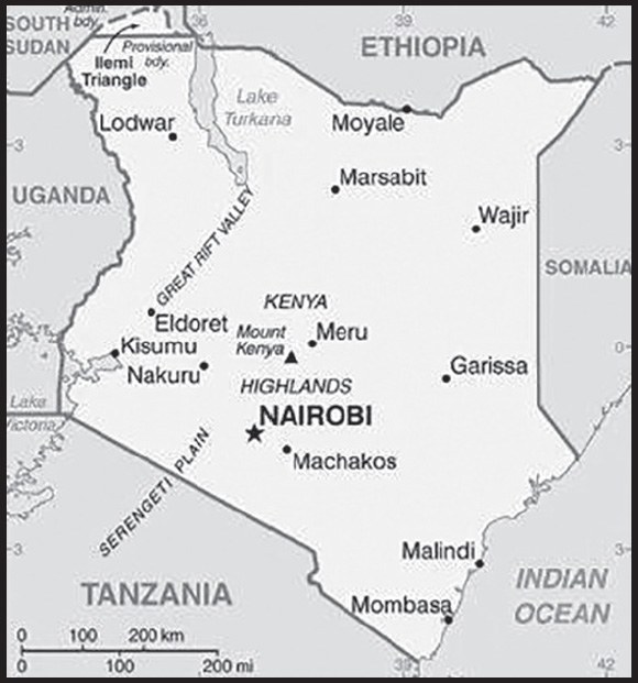
Background: Trade centers such as Mombasa have existed along the Kenyan and Tanzanian coastlines, known as the Land of Zanj, since at least the 2nd century. These centers traded with the outside world, including China, India, Indonesia, the Middle East, North Africa, and Persia. By around the 9th century, the mix of Africans, Arabs, and Persians who lived and traded there became known as Swahili (“people of the coast”) with a distinct language (KiSwahili) and culture. The Portuguese arrived in the 1490s and, using Mombasa as a base, sought to monopolize trade in the Indian Ocean. The Portuguese were pushed out in the late 1600s by the combined forces of Oman and Pate, an island off the coast. In 1890, Germany and the UK divided up the region, with the UK taking the north and the Germans the south, including present-day Tanzania, Burundi, and Rwanda. The British established the East Africa Protectorate in 1895, which in 1920 was converted into a colony and named Kenya after its highest mountain. Numerous political disputes between the colony and the UK subsequently led to the violent Mau Mau Uprising, which began in 1952, and the eventual declaration of independence in 1963.
Jomo KENYATTA, the founding president and an icon of the liberation struggle, led Kenya from independence in 1963 until his death in 1978, when Vice President Daniel Arap MOI took power in a constitutional succession. The country was a de facto one-party state from 1969 until 1982, after which time the ruling Kenya African National Union (KANU) changed the constitution to make itself the sole legal political party in Kenya. MOI acceded to internal and external pressure for political liberalization in late 1991. The ethnically fractured opposition failed to dislodge KANU from power in elections in 1992 and 1997, which were marred by violence and fraud. President MOI stepped down in December 2002 following fair and peaceful elections. Mwai KIBAKI, running as the candidate of the multiethnic, united opposition group, the National Rainbow Coalition (NARC), defeated KANU candidate Uhuru KENYATTA, the son of founding president Jomo KENYATTA, and assumed the presidency following a campaign centered on an anticorruption platform.
KIBAKI’s reelection in 2007 resulted in two months of post-election ethnic violence that caused the death of more than 1,100 people and the dislocation of hundreds of thousands. Opposition candidate, Raila ODINGA, accused the government of widespread vote rigging. African Union-sponsored mediation led by former UN Secretary General Kofi ANNAN resulted in a power-sharing accord that brought ODINGA into the government in the restored position of prime minister. The power sharing accord included a broad reform agenda, the centerpiece of which was constitutional reform. In 2010, Kenyans overwhelmingly adopted a new constitution in a national referendum. The new constitution introduced additional checks and balances to executive power and devolved power and resources to 47 newly created counties. It also eliminated the position of prime minister. Uhuru KENYATTA won the first presidential election under the new constitution in March 2013. KENYATTA won a second and final term in office in November 2017 following a contentious, repeat election. In August 2022, William RUTO won a close presidential election; he assumed the office the following month after the Kenyan Supreme Court upheld the victory.
GEOGRAPHY
Location: Eastern Africa, bordering the Indian Ocean, between Somalia and Tanzania
Geographic coordinates: 1 00 N, 38 00 E
Map references: Africa
Area: total: 580,367 sq km
land: 569,140 sq km
water: 11,227 sq km
comparison ranking: total 51
Area - comparative: five times the size of Ohio; slightly more than twice the size of Nevada
Land boundaries: total: 3,457 km
border countries (5): Ethiopia 867 km; Somalia 684 km; South Sudan 317 km; Tanzania 775 km; Uganda 814 km
Coastline: 536 km
Maritime claims: territorial sea: 12 nm
exclusive economic zone: 200 nm
continental shelf: 200-m depth or to the depth of exploitation
Climate: varies from tropical along coast to arid in interior
Terrain: low plains rise to central highlands bisected by Great Rift Valley; fertile plateau in west
Elevation: highest point: Mount Kenya 5,199 m
lowest point: Indian Ocean 0 m
mean elevation: 762 m
Natural resources: limestone, soda ash, salt, gemstones, fluorspar, zinc, diatomite, gypsum, wildlife, hydropower
Land use: agricultural land: 48.1% (2018 est.)
arable land: 9.8% (2018 est.)
permanent crops: 0.9% (2018 est.)
permanent pasture: 37.4% (2018 est.)
forest: 6.1% (2018 est.)
other: 45.8% (2018 est.)
Irrigated land: 1,030 sq km (2012)
Major lakes (area sq km): fresh water lake(s): Lake Victoria (shared with Tanzania and Uganda) - 62,940 sq km
salt water lake(s): Lake Turkana (shared with Ethiopia) - 6,400 sq km
Major watersheds (area sq km): Atlantic Ocean drainage: (Mediterranean Sea) Nile (3,254,853 sq km)
Major aquifers: Ogaden-Juba Basin
Population distribution: population heavily concentrated in the west along the shore of Lake Victoria; other areas of high density include the capital of Nairobi, and in the southeast along the Indian Ocean coast as shown in this population distribution map
Natural hazards: recurring drought; flooding during rainy seasons
volcanism: limited volcanic activity; the Barrier (1,032 m) last erupted in 1921; South Island is the only other historically active volcano
Geography - note: the Kenyan Highlands comprise one of the most successful agricultural production regions in Africa; glaciers are found on Mount Kenya, Africa’s second highest peak; unique physiography supports abundant and varied wildlife of scientific and economic value; Lake Victoria, the world’s largest tropical lake and the second largest fresh water lake, is shared among three countries: Kenya, Tanzania, and Uganda
PEOPLE AND SOCIETY
Population: 57,052,004 (2023 est.)
comparison ranking: 27
Nationality: noun: Kenyan(s)
adjective: Kenyan
Ethnic groups: Kikuyu 17.1%, Luhya 14.3%, Kalenjin 13.4%, Luo 10.7%, Kamba 9.8%, Somali 5.8%, Kisii 5.7%, Mijikenda 5.2%, Meru 4.2%, Maasai 2.5%, Turkana 2.1%, non-Kenyan 1%, other 8.2% (2019 est.)
Languages: English (official), Kiswahili (official), numerous indigenous languages
major-language sample(s):
The World Factbook, the indispensable source for basic information. (English)
The World Factbook, Chanzo cha Lazima Kuhusu Habari ya Msingi. (Kiswahili)
Religions: Christian 85.5% (Protestant 33.4%, Catholic 20.6%, Evangelical 20.4%, African Instituted Churches 7%, other Christian 4.1%), Muslim 10.9%, other 1.8%, none 1.6%, don’t know/no answer 0.2% (2019 est.)
Demographic profile: Kenya has experienced dramatic population growth since the mid-20th century as a result of its high birth rate and its declining mortality rate. Almost 40% of Kenyans are under the age of 15 as of 2020 because of sustained high fertility, early marriage and childbearing, and an unmet need for family planning. Kenya’s persistent rapid population growth strains the labor market, social services, arable land, and natural resources. Although Kenya in 1967 was the first Sub-Saharan country to launch a nationwide family planning program, progress in reducing the birth rate has largely stalled since the late 1990s, when the government decreased its support for family planning to focus on the HIV epidemic. Government commitment and international technical support spurred Kenyan contraceptive use, decreasing the fertility rate (children per woman) from about 8 in the late 1970s to less than 5 children twenty years later, but it has plateaued at about 3 children as of 2022.
Kenya is a source of emigrants and a host country for refugees. In the 1960s and 1970s, Kenyans pursued higher education in the UK because of colonial ties, but as British immigration rules tightened, the US, the then Soviet Union, and Canada became attractive study destinations. Kenya’s stagnant economy and political problems during the 1980s and 1990s led to an outpouring of Kenyan students and professionals seeking permanent opportunities in the West and southern Africa. Nevertheless, Kenya’s relative stability since its independence in 1963 has attracted hundreds of thousands of refugees escaping violent conflicts in neighboring countries; Kenya was sheltering nearly 280,000 Somali refugees as of 2022.
Age structure: 0-14 years: 36.45% (male 10,447,425/female 10,349,611)
15-64 years: 60.26% (male 17,196,347/female 17,185,035)
65 years and over: 3.28% (2023 est.) (male 855,757/female 1,017,829)
Dependency ratios: total dependency ratio: 70.2
youth dependency ratio: 65.3
elderly dependency ratio: 4.8
potential support ratio: 20.7 (2021 est.)
Median age: total: 20 years (2020)
male: 19.9 years
female: 20.1 years
comparison ranking: total 195
Population growth rate: 2.09% (2023 est.)
comparison ranking: 38
Birth rate: 26.01 births/1,000 population (2023 est.)
comparison ranking: 42
Death rate: 4.95 deaths/1,000 population (2023 est.)
comparison ranking: 195
Net migration rate: -0.19 migrant(s)/1,000 population (2023 est.)
comparison ranking: 107
Population distribution: population heavily concentrated in the west along the shore of Lake Victoria; other areas of high density include the capital of Nairobi, and in the southeast along the Indian Ocean coast as shown in this population distribution map
Urbanization: urban population: 29.5% of total population (2023)
rate of urbanization: 4.09% annual rate of change (2020-25 est.)
Major urban areas - population: 5.325 million NAIROBI (capital), 1.440 million Mombassa (2023)
Sex ratio: at birth: 1.02 male(s)/female
0-14 years: 1.01 male(s)/female
15-64 years: 1 male(s)/female
65 years and over: 0.84 male(s)/female
total population: 1 male(s)/female (2023 est.)
Mother’s mean age at first birth: 20.3 years (2014 est.)
note: data represents median age at first birth among women 25-49
Maternal mortality ratio: 530 deaths/100,000 live births (2020 est.)
comparison ranking: 12
Infant mortality rate: total: 26.94 deaths/1,000 live births (2023 est.)
male: 29.94 deaths/1,000 live births
female: 23.88 deaths/1,000 live births
comparison ranking: total 59
Life expectancy at birth: total population: 70.04 years (2023 est.)
male: 68.31 years
female: 71.82 years
comparison ranking: total population 174
Total fertility rate: 3.23 children born/woman (2023 est.)
comparison ranking: 44
Gross reproduction rate: 1.6 (2023 est.)
Contraceptive prevalence rate: 64.6% (2020)
Drinking water source: improved: urban: 91.3% of population
rural: 63.3% of population
total: 71.2% of population
unimproved: urban: 8.7% of population
rural: 36.7% of population
total: 28.8% of population (2020 est.)
Current health expenditure: 4.3% of GDP (2020)
Physicians density: 0.16 physicians/1,000 population (2018)
Sanitation facility access: improved: urban: 84% of population
rural: 48.1% of population
total: 58.2% of population
unimproved: urban: 16% of population
rural: 51.9% of population
total: 41.8% of population (2020 est.)
Major infectious diseases: degree of risk: very high (2023)
food or waterborne diseases: bacterial and protozoal diarrhea, hepatitis A, and typhoid fever
vectorborne diseases: malaria, dengue fever, and Rift Valley fever
water contact diseases: schistosomiasis
animal contact diseases: rabies
Obesity - adult prevalence rate: 7.1% (2016)
comparison ranking: 161
Alcohol consumption per capita: total: 1.68 liters of pure alcohol (2019 est.)
beer: 0.81 liters of pure alcohol (2019 est.)
wine: 0.04 liters of pure alcohol (2019 est.)
spirits: 0.81 liters of pure alcohol (2019 est.)
other alcohols: 0.03 liters of pure alcohol (2019 est.)
comparison ranking: total 134
Tobacco use: total: 11.1% (2020 est.)
male: 19.5% (2020 est.)
female: 2.7% (2020 est.)
comparison ranking: total 129
Children under the age of 5 years underweight: 10.1% (2022)
comparison ranking: 56
Currently married women (ages 15-49): 56.8% (2023 est.)
Education expenditures: 4.8% of GDP (2021 est.)
comparison ranking: 83
Literacy: definition: age 15 and over can read and write
total population: 82.6%
male: 85.5%
female: 79.8% (2021)
Youth unemployment rate (ages 15-24): total: 13.8% (2021 est.)
male: 12.8%
female: 14.9%
comparison ranking: total 128
ENVIRONMENT
Environment - current issues: water pollution from urban and industrial wastes; water shortage and degraded water quality from increased use of pesticides and fertilizers; flooding; water hyacinth infestation in Lake Victoria; deforestation; soil erosion; desertification; poaching
Environment - international agreements: party to: Biodiversity, Climate Change, Climate Change-Kyoto Protocol, Climate Change-Paris Agreement, Comprehensive Nuclear Test Ban, Desertification, Endangered Species, Hazardous Wastes, Law of the Sea, Marine Dumping-London Convention, Marine Dumping-London Protocol, Marine Life Conservation, Nuclear Test Ban, Ozone Layer Protection, Ship Pollution, Wetlands, Whaling
signed, but not ratified: none of the selected agreements
Climate: varies from tropical along coast to arid in interior
Land use: agricultural land: 48.1% (2018 est.)
arable land: 9.8% (2018 est.)
permanent crops: 0.9% (2018 est.)
permanent pasture: 37.4% (2018 est.)
forest: 6.1% (2018 est.)
other: 45.8% (2018 est.)
Urbanization: urban population: 29.5% of total population (2023)
rate of urbanization: 4.09% annual rate of change (2020-25 est.)
Food insecurity: exceptional shortfall in aggregate food production/supplies: due to drought conditions - about 4.4 million people were projected to be severely acutely food insecure between October and December 2022 reflecting consecutive poor rainy seasons since late 2020 that affected crop and livestock production; prices of maize are at high levels across the country due to reduced availabilities and high fuel prices inflating production and transportation costs (2023)
Revenue from forest resources: 1.3% of GDP (2018 est.)
comparison ranking: 47
Revenue from coal: 0% of GDP (2018 est.)
comparison ranking: 142
Air pollutants: particulate matter emissions: 12.52 micrograms per cubic meter (2019 est.)
carbon dioxide emissions: 17.91 megatons (2016 est.)
methane emissions: 37.65 megatons (2020 est.)
Waste and recycling: municipal solid waste generated annually: 5,595,099 tons (2010 est.)
municipal solid waste recycled annually: 447,608 tons (2009 est.)
percent of municipal solid waste recycled: 8% (2009 est.)
Major lakes (area sq km): fresh water lake(s): Lake Victoria (shared with Tanzania and Uganda) - 62,940 sq km
salt water lake(s): Lake Turkana (shared with Ethiopia) - 6,400 sq km
Major watersheds (area sq km): Atlantic Ocean drainage: (Mediterranean Sea) Nile (3,254,853 sq km)
Major aquifers: Ogaden-Juba Basin
Total water withdrawal: municipal: 500 million cubic meters (2020 est.)
industrial: 300 million cubic meters (2020 est.)
agricultural: 3.23 billion cubic meters (2020 est.)
Total renewable water resources: 30.7 billion cubic meters (2020 est.)
GOVERNMENT
Country name: conventional long form: Republic of Kenya
conventional short form: Kenya
local long form: Republic of Kenya (English)/ Jamhuri ya Kenya (Swahili)
local short form: Kenya
former: British East Africa
etymology: named for Mount Kenya; the meaning of the name is unclear but may derive from the Kikuyu, Embu, and Kamba words “kirinyaga,” “kirenyaa,” and “kiinyaa” - all of which mean “God’s resting place”
Government type: presidential republic
Capital: name: Nairobi
geographic coordinates: 1 17 S, 36 49 E
time difference: UTC+3 (8 hours ahead of Washington, DC, during Standard Time)
etymology: the name derives from the Maasai expression meaning “cool waters” and refers to a cold water stream that flowed through the area in the late 19th century
Administrative divisions: 47 counties; Baringo, Bomet, Bungoma, Busia, Elgeyo/Marakwet, Embu, Garissa, Homa Bay, Isiolo, Kajiado, Kakamega, Kericho, Kiambu, Kilifi, Kirinyaga, Kisii, Kisumu, Kitui, Kwale, Laikipia, Lamu, Machakos, Makueni, Mandera, Marsabit, Meru, Migori, Mombasa, Murang’a, Nairobi City, Nakuru, Nandi, Narok, Nyamira, Nyandarua, Nyeri, Samburu, Siaya, Taita/Taveta, Tana River, Tharaka-Nithi, Trans Nzoia, Turkana, Uasin Gishu, Vihiga, Wajir, West Pokot
Independence: 12 December 1963 (from the UK)
National holiday: Jamhuri Day (Independence Day), 12 December (1963); note - Madaraka Day, 1 June (1963) marks the day Kenya attained internal self-rule
Constitution: history: current constitution passed by referendum on 4 August 2010
amendments: amendments can be proposed by either house of Parliament or by petition of at least one million eligible voters; passage of amendments by Parliament requires approval by at least two-thirds majority vote of both houses in each of two readings, approval in a referendum by majority of votes cast by at least 20% of eligible voters in at least one half of Kenya’s counties, and approval by the president; passage of amendments introduced by petition requires approval by a majority of county assemblies, approval by majority vote of both houses, and approval by the president
Legal system: mixed legal system of English common law, Islamic law, and customary law; judicial review in the new Supreme Court established by the new constitution
International law organization participation: accepts compulsory ICJ jurisdiction with reservations; accepts ICCt jurisdiction
Citizenship: citizenship by birth: no
citizenship by descent only: at least one parent must be a citizen of Kenya
dual citizenship recognized: yes
residency requirement for naturalization: 4 out of the previous 7 years
Suffrage: 18 years of age; universal
Executive branch: chief of state: President William RUTO (since 13 September 2022); note - the president is both chief of state and head of government
head of government: President William RUTO (since 13 September 2022)
cabinet: Cabinet appointed by the president, subject to confirmation by the National Assembly
elections/appointments: president and deputy president directly elected on the same ballot by majority vote nationwide and at least 25% of the votes cast in at least 24 of the 47 counties; failure to meet these thresholds requires a runoff between the top two candidates; election last held on 9 August 2022 (next to be held in 2027)
election results:
2017: Uhuru KENYATTA reelected president; percent of vote - Uhuru KENYATTA (JP) 98.3%, Raila ODINGA (ODM) 1%, other 0.7%; note - Kenya held a previous presidential election on 8 August 2017, but Kenya’s Supreme Court on 1 September 2017 nullified the results, citing irregularities; the political opposition boycotted the October vote
2013: Uhuru KENYATTA elected president in first round; percent of vote - Uhuru KENYATTA (TNA) 50.1%, Raila ODINGA (ODM) 43.7%, Musalia MUDAVADI (UDF) 4.0%, other 2.2%
Legislative branch: description: bicameral Parliament consists of:
Senate (68 seats; 47 members directly elected in single-seat constituencies by simple majority vote and 20 directly elected by proportional representation vote - 16 women, 2 representing youth, 2 representing the disabled, and one Senate speaker; members serve 5-year terms)
National Assembly (350 seats; 290 members directly elected in single-seat constituencies by simple majority vote, 47 women in single-seat constituencies elected by simple majority vote, and 12 members nominated by the National Assembly - 6 representing youth and 6 representing the disabled, and one Assembly speaker; members serve 5-year terms)
elections: Senate - last held on 9 August 2022 (next to be held in August 2027)
National Assembly - last held on 9 August 2022 (next to be held in August 2027)
election results: Senate - percent of vote by party/coalition - NA; seats by party/coalition - Kenya Kwanza 34; Azimio La Umoja 33; composition - men 47, women 21, percent of women is 31%
National Assembly - percent of vote by party/coalition - NA; seats by party/coalition - Azimio La Umoja 173, Kenya Kwanza 161, independent 12, other 3; composition - men 275, women 75, percent of women 21.4%; note - total Parliament percent of women 23%
Judicial branch: highest court(s): Supreme Court (consists of chief and deputy chief justices and 5 judges)
judge selection and term of office: chief and deputy chief justices nominated by Judicial Service Commission (JSC) and appointed by the president with approval of the National Assembly; other judges nominated by the JSC and appointed by president; chief justice serves a nonrenewable 10-year term or until age 70, whichever comes first; other judges serve until age 70
subordinate courts: High Court; Court of Appeal; military courts; magistrates’ courts; religious courts
Political parties and leaders: Azimio La Umoja–One Kenya Coalition Party [Raila ODINGA] (includes DAP-K, JP, KANU, KUP, MCC, MDG, ODM, PAA, UDM, UDP, UPA, UPIA, and WDM-K)
Amani National Congress or ANC [Musalia MUDAVADI]
Chama Cha Kazi or CCK [Moses KURIA]
Democratic Action Party or DAP-K [Wafula WAMUNYINYI]
Democratic Party or DP [Joseph MUNYAO, Chairman]
Forum for the Restoration of Democracy–Kenya or FORD-Kenya [Moses WETANGULA]
Grand Dream Development Party or GDDP [Fabian KYULE]
Jubilee Party or JP [Uhuru KENYATTA] (previously the National Alliance Pary)
Kenya African National Union or KANU [Gideon MOI]
Kenya Kwanza coalition [William RUTO] (includes ANC, CCK, DP, FORD-Kenya, TSP, and UDA)
Kenya Union Party or KUP [John LONYANGAPUO]
Maendeleo Chap Chap Party or MCC [Alfred MUTUA]
Movement for Democracy and Growth or MDG [David OCHIENG]
National Agenda Party or NAP-K [Alfayo AGUFANA]
National Ordinary People Empowerment Union or NOPEU [Rodgers MPURU, Secretary General}
Orange Democratic Movement or ODM [Raila ODINGA]
Pamoja African Alliance or PAA [Amason KINGI]
The Service Party or TSP [Mwangi KIUNJURI]
United Democratic Alliance or UDA [William RUTO]
United Democratic Movement or UDM [Philip MURGOR]
United Democratic Party or UDP [Cyrus Jirongo]
United Party of Independent Alliance or UPIA [Ukur YATANI]
United Progressive Alliance or UPA [Kenneth NYAMWAMU]
Wiper Democratic Movement-Kenya or WDM-K [Kalonzo MUSYOKA]
note: includes only parties with seats in the Senate and National Assembly
International organization participation: ACP, AfDB, ATMIS, AU, C, CD, COMESA, EAC, EADB, FAO, G-15, G-77, IAEA, IBRD, ICAO, ICCT, ICRM, IDA, IFAD, IFC, IFRCS, IGAD, ILO, IMF, IMO, IMSO, Interpol, IOC, IOM, IPU, ISO, ITSO, ITU, ITUC (NGOs), MIGA, MINUSMA, MONUSCO, NAM, OPCW, PCA, UN, UNAMID, UNCTAD, UNESCO, UNHCR, UNIDO, UNIFIL, UNISFA, UNMIL, UNMISS, UNSOM, UNWTO, UPU, WCO, WHO, WMO, WTO
Diplomatic representation in the US: chief of mission: Ambassador Lazarus Ombai AMAYO (since 17 July 2020)
chancery: 2249 R St NW, Washington, DC 20008
telephone: [1] (202) 387-6101
FAX: [1] (202) 462-3829
email address and website:
information@kenyaembassydc.org
consulate(s) general: Los Angeles
consulate(s): New York
Diplomatic representation from the US: chief of mission: Ambassador Margaret “Meg” WHITMAN (since 5 August 2022)
embassy: P.O. Box 606 Village Market, 00621 Nairobi
mailing address: 8900 Nairobi Place, Washington, DC 20521-8900
telephone: [254] (20) 363-6000
FAX: [254] (20) 363-6157
email address and website:
Flag description: three equal horizontal bands of black (top), red, and green; the red band is edged in white; a large Maasai warrior’s shield covering crossed spears is superimposed at the center; black symbolizes the majority population, red the blood shed in the struggle for freedom, green stands for natural wealth, and white for peace; the shield and crossed spears symbolize the defense of freedom
National symbol(s): lion; national colors: black, red, green, white
National anthem: name: “Ee Mungu Nguvu Yetu” (Oh God of All Creation)
lyrics/music: Graham HYSLOP, Thomas KALUME, Peter KIBUKOSYA, Washington OMONDI, and George W. SENOGA-ZAKE/traditional, adapted by Graham HYSLOP, Thomas KALUME, Peter KIBUKOSYA, Washington OMONDI, and George W. SENOGA-ZAKE
note: adopted 1963; based on a traditional Kenyan folk song
National heritage: total World Heritage Sites: 7 (4 cultural, 3 natural)
selected World Heritage Site locales: Lake Turkana National Parks (n); Mount Kenya National Park (n); Lamu Old Town (c); Sacred Mijikenda Kaya Forests (c); Fort Jesus, Mombasa (c); Kenya Lake System in the Great Rift Valley (n); Thimlich Ohinga Archaeological Site (c)
ECONOMY
Economic overview: fast growing, third largest Sub-Saharan economy; strong agriculture and emerging services and tourism industries; current account deficit and high debt; broadband and mobile-money platform investments; surging inflation due to oil and food hikes; new investor-friendly incentives; environmentally fragile economy
Real GDP (purchasing power parity): $251.431 billion (2021 est.)
$233.852 billion (2020 est.)
$234.438 billion (2019 est.)
note: data are in 2017 dollars
comparison ranking: 62
Real GDP growth rate: 7.52% (2021 est.)
-0.25% (2020 est.)
5.11% (2019 est.)
comparison ranking: 50
Real GDP per capita: $4,700 (2021 est.)
$4,500 (2020 est.)
$4,600 (2019 est.)
note: data are in 2017 dollars
comparison ranking: 181
GDP (official exchange rate): $95.52 billion (2019 est.)
Inflation rate (consumer prices): 6.11% (2021 est.)
5.4% (2020 est.)
5.24% (2019 est.)
comparison ranking: 50
Credit ratings: Fitch rating: B+ (2007)
Moody’s rating: B2 (2018)
Standard & Poors rating: B+ (2010)
note: The year refers to the year in which the current credit rating was first obtained.
GDP - composition, by sector of origin: agriculture: 34.5% (2017 est.)
industry: 17.8% (2017 est.)
services: 47.5% (2017 est.)
comparison rankings: services 191; industry 164; agriculture 13
GDP - composition, by end use: household consumption: 79.5% (2017 est.)
government consumption: 14.3% (2017 est.)
investment in fixed capital: 18.9% (2017 est.)
investment in inventories: -1% (2017 est.)
exports of goods and services: 13.9% (2017 est.)
imports of goods and services: -25.5% (2017 est.)
Agricultural products: milk, tea, beef, maize, sugar cane, tomatoes, mangoes/guavas, potatoes, beans, bananas
Industries: agriculture, transportation, services, manufacturing, construction, telecommunications, tourism, retail
Industrial production growth rate: 7.17% (2021 est.)
comparison ranking: 59
Labor force: 23.915 million (2021 est.)
comparison ranking: 27
Labor force - by occupation: agriculture: 61.1%
industry: 6.7%
services: 32.2% (2005 est.)
Unemployment rate: 5.74% (2021 est.)
5.73% (2020 est.)
5.01% (2019 est.)
comparison ranking: 132
Youth unemployment rate (ages 15-24): total: 13.8% (2021 est.)
male: 12.8%
female: 14.9%
comparison ranking: total 128
Population below poverty line: 36.1% (2015 est.)
Gini Index coefficient - distribution of family income: 40.8 (2015 est.)
comparison ranking: 51
Average household expenditures: on food: 52.9% of household expenditures (2018 est.)
on alcohol and tobacco: 4.1% of household expenditures (2018 est.)
Household income or consumption by percentage share: lowest 10%: 1.8%
highest 10%: 37.8% (2005)
Budget: revenues: $16.885 billion (2019 est.)
expenditures: $24.271 billion (2019 est.)
Budget surplus (+) or deficit (-): -6.7% (of GDP) (2017 est.)
comparison ranking: 190
Public debt: 54.2% of GDP (2017 est.)
53.2% of GDP (2016 est.)
comparison ranking: 91
Taxes and other revenues: 14.3% (of GDP) (2020 est.)
comparison ranking: 153
Fiscal year: 1 July - 30 June
Current account balance: -$5.744 billion (2021 est.)
-$4.792 billion (2020 est.)
-$5.258 billion (2019 est.)
comparison ranking: 191
Exports: $11.825 billion (2021 est.) note: data are in current year dollars
$9.709 billion (2020 est.) note: data are in current year dollars
$11.471 billion (2019 est.)
comparison ranking: 96
Exports - partners: Uganda 14%, Pakistan 8%, Netherlands 8%, United States 8%, United Kingdom 7% (2020)
Exports - commodities: tea, cut flowers, coffee, refined petroleum, titanium (2021)
Imports: $21.853 billion (2021 est.) note: data are in current year dollars
$17.717 billion (2020 est.) note: data are in current year dollars
$20.408 billion (2019 est.)
comparison ranking: 89
Imports - partners: China 27%, India 11%, United Arab Emirates 7%, Japan 4%, Saudi Arabia 3% (2020)
Imports - commodities: refined petroleum, palm oil, broadcasting equipment, packaged medicines, cars (2020)
Reserves of foreign exchange and gold: $9.491 billion (31 December 2021 est.)
$8.297 billion (31 December 2020 est.)
$9.116 billion (31 December 2019 est.)
comparison ranking: 85
Debt - external: $29.289 billion (2019 est.)
$25.706 billion (2018 est.)
comparison ranking: 86
Exchange rates: Kenyan shillings (KES) per US dollar -
Exchange rates: 109.638 (2021 est.)
106.451 (2020 est.)
101.991 (2019 est.)
101.302 (2018 est.)
103.41 (2017 est.)
ENERGY
Electricity access: population without electricity: 12 million (2020)
electrification - total population: 76.5% (2021)
electrification - urban areas: 97.5% (2021)
electrification - rural areas: 68.1% (2021)
Electricity: installed generating capacity: 3.304 million kW (2020 est.)
consumption: 8.243 billion kWh (2019 est.)
exports: 16 million kWh (2019 est.)
imports: 277 million kWh (2019 est.)
transmission/distribution losses: 2.724 billion kWh (2019 est.)
comparison rankings: installed generating capacity 104; transmission/distribution losses 71; imports 97; exports 95; consumption 106
Electricity generation sources: fossil fuels: 8.3% of total installed capacity (2020 est.)
solar: 1% of total installed capacity (2020 est.)
wind: 10.7% of total installed capacity (2020 est.)
hydroelectricity: 32.6% of total installed capacity (2020 est.)
geothermal: 46.2% of total installed capacity (2020 est.)
biomass and waste: 1.2% of total installed capacity (2020 est.)
Coal: production: 0 metric tons (2020 est.)
consumption: 821,000 metric tons (2020 est.)
exports: 0 metric tons (2020 est.)
imports: 822,000 metric tons (2020 est.)
proven reserves: 0 metric tons (2019 est.)
Petroleum: total petroleum production: 0 bbl/day (2021 est.)
refined petroleum consumption: 116,400 bbl/day (2019 est.)
Refined petroleum products - production: 13,960 bbl/day (2015 est.)
comparison ranking: 96
Refined petroleum products - exports: 173 bbl/day (2015 est.)
comparison ranking: 118
Refined petroleum products - imports: 90,620 bbl/day (2015 est.)
comparison ranking: 57
Natural gas: production: 0 cubic meters (2021 est.)
consumption: 0 cubic meters (2021 est.)
exports: 0 cubic meters (2021 est.)
imports: 0 cubic meters (2021 est.)
proven reserves: 0 cubic meters (2021 est.)
Carbon dioxide emissions: 17.709 million metric tonnes of CO2 (2019 est.)
from coal and metallurgical coke: 1.25 million metric tonnes of CO2 (2019 est.)
from petroleum and other liquids: 16.459 million metric tonnes of CO2 (2019 est.)
from consumed natural gas: 0 metric tonnes of CO2 (2019 est.)
comparison ranking: total emissions 90
Energy consumption per capita: 6.31 million Btu/person (2019 est.)
comparison ranking: 166
COMMUNICATIONS
Telephones - fixed lines: total subscriptions: 61,096 (2021 est.)
subscriptions per 100 inhabitants: (2021 est.) less than 1
comparison ranking: total subscriptions 148
Telephones - mobile cellular: total subscriptions: 65,085,720 (2021 est.)
subscriptions per 100 inhabitants: 123 (2021 est.)
comparison ranking: total subscriptions 26
Telecommunication systems: general assessment: Kenya’s telecom market continues to undergo considerable changes in the wake of increased competition, improved international connectivity, and rapid developments in the mobile market; the country is directly connected to a number of submarine cables, and with Mombasa through a terrestrial network, the country serves as a key junction for onward connectivity to the Arabian states and the Far East; numerous competitors are rolling out national and metropolitan backbone networks and wireless access networks to deliver services to population centers across the country; several fiber infrastructure sharing agreements have been forged, and as a result the number of fiber broadband connections has increased sharply in recent years; much of the progress in the broadband segment is due to the government’s revised national broadband strategy, which has been updated with goals through to 2030, and which are largely dependent on mobile broadband platforms based on LTE and 5G (2022)
domestic: fixed-line subscriptions stand at less than 1 per 100 persons; mobile-cellular subscriptions at 123 per 100 persons (2021)
international: country code - 254; landing point for the EASSy, TEAMS, LION2, DARE1, PEACE Cable, and SEACOM fiber-optic submarine cable systems covering East, North and South Africa, Europe, the Middle East, and Asia; satellite earth stations - 4 Intelsat; launched first micro satellites in 2018 (2019)
Broadcast media: about a half-dozen large-scale privately owned media companies with TV and radio stations, as well as a state-owned TV broadcaster, provide service nationwide; satellite and cable TV subscription services available; state-owned radio broadcaster operates 2 national radio channels and provides regional and local radio services in multiple languages; many private radio stations broadcast on a national level along with over 100 private and non-profit regional stations broadcasting in local languages; TV transmissions of all major international broadcasters available, mostly via paid subscriptions; direct radio frequency modulation transmissions available for several foreign government-owned broadcasters (2019)
Internet country code: .ke
Internet users: total: 15.37 million (2021 est.)
percent of population: 29% (2021 est.)
comparison ranking: total 49
Broadband - fixed subscriptions: total: 674,191 (2020 est.)
subscriptions per 100 inhabitants: 1 (2020 est.)
comparison ranking: total 82
TRANSPORTATION
National air transport system: number of registered air carriers: 25 (2020)
inventory of registered aircraft operated by air carriers: 188
annual passenger traffic on registered air carriers: 5,935,831 (2018)
annual freight traffic on registered air carriers: 294.97 million (2018) mt-km
Civil aircraft registration country code prefix: 5Y
Airports: 197 (2021)
comparison ranking: total 29
Airports - with paved runways: 16
note: paved runways have a concrete or asphalt surface but not all have facilities for refueling, maintenance, or air traffic control; the length of a runway required for aircraft to safely operate depends on a number of factors including the type of aircraft, the takeoff weight (including passengers, cargo, and fuel), engine types, flap settings, landing speed, elevation of the airport, and average maximum daily air temperature; paved runways can reach a length of 5,000 m (16,000 ft.), but the “typical” length of a commercial airline runway is between 2,500-4,000 m (8,000-13,000 ft.)
Airports - with unpaved runways: 181
note: unpaved runways have a surface composition such as grass or packed earth and are most suited to the operation of light aircraft; unpaved runways are usually short, often less than 1,000 m (3,280 ft.) in length; airports with unpaved runways often lack facilities for refueling, maintenance, or air traffic control
Pipelines: 4 km oil, 1,432 km refined products (2018)
Railways: total: 3,819 km (2018)
standard gauge: 485 km (2018) 1.435-m gauge
narrow gauge: 3,334 km (2018) 1.000-m gauge
comparison ranking: total 51
Roadways: total: 161,452 km (2018)
paved: 14,420 km (2017) (8,500 km highways, 1,872 urban roads, and 4,048 rural roads)
unpaved: 147,032 km (2017)
comparison ranking: total 32
Waterways: (2011) none specifically; the only significant inland waterway is the part of Lake Victoria within the boundaries of Kenya; Kisumu is the main port and has ferry connections to Uganda and Tanzania
Merchant marine: total: 25 (2022)
by type: oil tanker 3, other 22
comparison ranking: total 140
Ports and terminals: major seaport(s): Kisumu, Mombasa
LNG terminal(s) (import): Mombasa
MILITARY AND SECURITY
Military and security forces: Kenya Defense Forces (KDF): Kenya Army, Kenya Navy, Kenya Air Force (2023)
note 1: the National Police Service maintains internal security and reports to the Ministry of Interior and Coordination of National Government; it includes a paramilitary General Service Unit and Rapid Deployment Unit
note 2: the Kenya Coast Guard Service (established 2018) is under the Ministry of Interior but led by a military officer and comprised of personnel from the military, as well as the National Police Service, intelligence services, and other government agencies
Military expenditures: 1.1% of GDP (2022 est.)
1.2% of GDP (2021 est.)
1.2% of GDP (2020 est.)
1.2% of GDP (2019 est.)
1.3% of GDP (2018 est.)
comparison ranking: 118
Military and security service personnel strengths: approximately 24,000 personnel (20,000 Army; 1,500 Navy; 2,500 Air Force) (2023)
Military equipment inventories and acquisitions: the KDF’s inventory traditionally carried mostly older or second-hand Western weapons systems, particularly from France, the UK, and the US; however, since the 2000s it has sought to modernize and diversify its imports, and suppliers have included several countries including China, Italy, and the US (2023)
Military service age and obligation: no conscription; 18-26 years of age for voluntary service for men and women (under 18 with parental consent; upper limit 30 years of age for specialists, tradesmen, or women with a diploma; 39 years of age for chaplains/imams); 9-year service obligation (7 years for Kenyan Navy) and subsequent 3-year re-enlistments; applicants must be Kenyan citizens (2023)
Military deployments: 260 Democratic Republic of the Congo (MONUSCO); up to 3,600 troops deployed in Somalia under ATMIS (note - ATMIS troop contingents are drawing down towards a final exit in December 2024) (2023)
note: in November 2022, Kenya sent approximately 1,000 troops to the eastern part of the Democratic Republic of the Congo (DRC) as part of a newly formed East Africa Community Regional Force (EACRF) to assist the DRC military against the rebel group M23; the force is led by Kenya
Military - note: the KDF is considered to be an experienced, effective, and professional force; it has conducted operations in neighboring Somalia since 2011 and taken part in numerous regional peacekeeping and security missions; it is a leading member of the Africa Standby Force; the KDF trains regularly, participates in multinational exercises, and has ties to a variety of foreign militaries, including those of France, the UK, and the US; its chief security concerns and missions include protecting the country’s sovereignty and territory, regional disputes, the threat posed by the al-Shabaab terrorist group based in neighboring Somalia, maritime crime and piracy, and assisting civil authorities in responding to emergency, disaster, or political unrest as requested
the Army has 5 combat brigades, including 3 infantry, an armored, and an artillery brigade; it also has a helicopter-equipped air cavalry battalion and a special operations regiment comprised of airborne, special forces, and ranger battalions; the Navy has several offshore patrol vessels, large coastal patrol boats, and missile-armed craft; the Air Force has a small inventory of older US-origin fighter aircraft, as well as some transport aircraft and combat helicopters
Kenyan military forces intervened in Somalia in October 2011 to combat the al Qaida-affiliated al-Shabaab terrorist group, which had conducted numerous cross-border attacks into Kenya; in November 2011, the UN and the African Union invited Kenya to incorporate its forces into the African Union Mission in Somalia (AMISOM); Kenyan forces were formally integrated into AMISOM in February 2012; they consist of approximately 3,600 troops and are responsible for AMISOM’s Sector 2 comprising Lower and Middle Jubba (see Appendix T for additional details on al-Shabaab; note - as of May 2022, AMISOM was renamed the AU Transition Mission in Somalia or ATMIS)
the Kenya Military Forces were created following independence in 1963; the current KDF was established and its composition laid out in the 2010 constitution; it is governed by the Kenya Defense Forces Act of 2012; the Army traces its origins back to the Kings African Rifles (KAR), a British colonial regiment raised from Britain’s East Africa possessions from 1902 until independence in the 1960s; the KAR conducted both military and internal security functions within the colonial territories, and served outside the territories during the World Wars (2023)
SPACE
Space agency/agencies: Kenya Space Agency (KSA; established, 2017); predecessor organization, the National Space Secretariat was established in 2009 (2023)
Space launch site(s): Luigi Broglio Space Center (aka Malindi Space Center, Malindi Station, San Marco Satellite Launching and Tracking Station; Kilifi County; over 20 sounding rockets and nine satellites launched from the site, 1967-1989); note – Kenya’s equatorial latitude makes it an attractive location for near-equatorial-orbit rocket and satellite launches (2023)
Space program overview: has a national space strategy focused on acquiring and applying space technologies and applications for agriculture, communications, disaster and resource management, security, urban planning, and weather monitoring; jointly develops and builds nanosatellites with foreign partners; operates satellites; researching and developing satellite payloads and imagery data analysis capabilities; has cooperated on space issues with China, Japan, Italy, and the US, as well as African partners; developing a satellite imagery/geospatial analysis and data sharing portal that contains 17 years of satellite imagery for other African countries, including Ghana, Senegal, Sierra Leone, and Tanzania; cooperating with Egypt, Ethiopia, Ghana, Nigeria, Sudan, and Uganda to establish a joint remote sensing (RS) satellite to monitor climate changes on the African continent (African Development Satellite program) (2023)
note: further details about the key activities, programs, and milestones of the country’s space program, as well as government spending estimates on the space sector, appear in Appendix S
TERRORISM
Terrorist group(s): Terrorist group(s): al-Shabaab; Islamic Revolutionary Guard Corps (IRGC)/Qods Force
note: details about the history, aims, leadership, organization, areas of operation, tactics, targets, weapons, size, and sources of support of the group(s) appear(s) in Appendix-T
TRANSNATIONAL ISSUES
Disputes - international: Kenya-Ethiopia: their border was demarcated in the 1950s and approved in 1970; in 2012, Kenya and Ethiopia agreed to redemarcate their boundary following disputes over beacons and cross-border crime
Kenya-Somalia: Kenya works hard to prevent the clan and militia fighting in Somalia from spreading across the border, which has long been open to nomadic pastoralists; in 2021, the International Court of Justice (ICJ) gave Somalia control over a disputed ocean area where the seabeds are believed to hold vasts oil and gas deposits; the ICJ ruling gave Somalia the rights to several offshore oil exploration blocks previously claimed by Kenya; Kenya did not recognize the court’s decision
Kenya-South Sudan: two thirds of the boundary that separates Kenya and South Sudan’s sovereignty known as the Ilemi Triangle has been unclear since British colonial times; Kenya has administered the area since colonial times; officials from Kenya and South Sudan signed a memorandum of understanding on boundary delimitation and demarcation and agreed to set up a joint committee; as of July 2019, the demarcation process was to begin in 90 days, but was delayed due to a lack of funding
Kenya-Sudan: Kenya served as an important mediator in brokering Sudan’s north-south separation in February 2005
Kenya-Tanzania: Kenya and Tanzania were conducting a joint reaffirmation process in November 2021 to ensure the border was visibly marked with pillars
Kenya-Uganda: Kenya and Uganda began a joint demarcation of the boundary in 2021
Refugees and internally displaced persons: refugees (country of origin): 290,635 (Somalia), 170,292 (South Sudan), 58,824 (Democratic Republic of the Congo), 21,847 (Ethiopia), 8,392 (Burundi), 5,756 (Sudan) (2023)
IDPs: 30,000 (election-related violence, intercommunal violence, resource conflicts, al-Shabaab attacks in 2017 and 2018) (2022)
stateless persons: 16,779 (2022); note - the stateless population consists of Nubians, Kenyan Somalis, and coastal Arabs; the Nubians are descendants of Sudanese soldiers recruited by the British to fight for them in East Africa more than a century ago; Nubians did not receive Kenyan citizenship when the country became independent in 1963; only recently have Nubians become a formally recognized tribe and had less trouble obtaining national IDs; Galjeel and other Somalis who have lived in Kenya for decades are included with more recent Somali refugees and denied ID cards
Illicit drugs: a transit country for illicit drugs and precursor chemicals; domestic drug consumption of cannabis and miraa (khat) is growing; heroin enters Kenya via Tanzania and in shipments across the Indian Ocean from Southwest Asia mostly destined for international markets, principally Europe; cocaine enters Kenya primarily via transshipment through Ethiopia
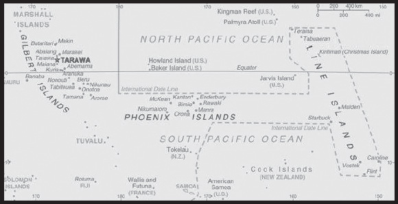
INTRODUCTION
Background: Kiribati is made up of three distinct island groups - the Gilbert Islands, the Line Islands, and the Phoenix Islands. The first Austronesian voyagers arrived in the Gilbert Islands as early as 3000 B.C., but these islands were not widely settled until about A.D. 200 by Micronesians. Around 1300, Samoans and Tongans invaded the southern Gilbert Islands, bringing Polynesian cultural elements with them. Later arrivals by Fijians brought Melanesian elements to the Gilbert Islands, and extensive intermarriage between the Micronesian, Polynesian, and Melanesian people led to the creation of what would become Gilbertese cultural traditions by the time Europeans spotted the islands in the 1600s. The Phoenix Islands and Line Islands were both visited by various Melanesian and Polynesian peoples, but their isolation and lack of natural resources meant that long-term settlements were not possible and both island groups were uninhabited by the time of European contact.
Kiribati experienced sustained European contact by the 1760s; all three island groups were named and charted by 1826. American whaling ships frequently passed through the islands, and the UK declared a protectorate over the Gilbert and nearby Ellice Islands in 1892 to block growing US influence. Phosphate-rich Banaba Island was annexed to the protectorate in 1900. In 1916, the protectorate became a colony, and some Line Islands were added in 1916 and 1919, with the final ones added in 1972. The Phoenix Islands were added to the colony in 1937, and the UK agreed to share jurisdiction of some of them with the US because of their strategic location for aviation. Japan occupied the northern Gilbert Islands in 1941; the islands of Makin and Tarawa were the sites of major US amphibious victories over entrenched Japanese garrisons in 1943. The UK continued to rule the colony after World War II. The Ellice Islands became its own colony in 1974. The Gilbert Islands became fully self-governing in 1977 and independent in 1979 as Kiribati, the Gilbertese spelling of Gilberts. The US relinquished all claims to the sparsely inhabited Phoenix and Line Islands in a 1979 treaty of friendship.
In 1994, Kiribati adjusted the international date line to the east of the Line Islands, bringing all islands in the country to the same day and giving Kiribati the earliest time zone in the world. Kiribati is a leading climate change advocate. In 2012, Kiribati purchased a 22 sq km (8.5 sq mi) plot of land in Fiji for potential eventual resettlement of its population because of climate change.
GEOGRAPHY
Location: Oceania, group of 32 coral atolls and one raised coral island in the Pacific Ocean, straddling the Equator; the capital Tarawa is about halfway between Hawaii and Australia
Geographic coordinates: 1 25 N, 173 00 E
Map references: Oceania
Area: total: 811 sq km
land: 811 sq km
water: 0 sq km
note: includes three island groups - Gilbert Islands, Line Islands, and Phoenix Islands - dispersed over about 3.5 million sq km (1.35 million sq mi)
comparison ranking: total 186
Area - comparative: four times the size of Washington, DC
Land boundaries: total: 0 km
Coastline: 1,143 km
Maritime claims: territorial sea: 12 nm
exclusive economic zone: 200 nm
Climate: tropical; marine, hot and humid, moderated by trade winds
Terrain: mostly low-lying coral atolls surrounded by extensive reefs
Elevation: highest point: unnamed elevation on Banaba 81 m
lowest point: Pacific Ocean 0 m
mean elevation: 2 m
Natural resources: phosphate (production discontinued in 1979), coconuts (copra), fish
Land use: agricultural land: 42% (2018 est.)
arable land: 2.5% (2018 est.)
permanent crops: 39.5% (2018 est.)
permanent pasture: 0% (2018 est.)
forest: 15% (2018 est.)
other: 43% (2018 est.)
Irrigated land: 0 sq km (2022)
Population distribution: consists of three achipelagos spread out over an area roughly the size of India; the eastern Line Islands and central Phoenix Islands are sparsely populated, but the western Gilbert Islands are some of the most densely settled places on earth, with the main island of South Tarawa boasting a population density similar to Tokyo or Hong Kong
Natural hazards: typhoons can occur any time, but usually November to March; occasional tornadoes; low level of some of the islands make them sensitive to changes in sea level
Geography - note: 21 of the 33 islands are inhabited; Banaba (Ocean Island) in Kiribati is one of the three great phosphate rock islands in the Pacific Ocean - the others are Makatea in French Polynesia, and Nauru; Kiribati is the only country in the world to fall into all four hemispheres (northern, southern, eastern, and western)
PEOPLE AND SOCIETY
Population: 115,372 (2023 est.)
comparison ranking: 189
Nationality: noun: I-Kiribati (singular and plural)
adjective: Kiribati
Ethnic groups: I-Kiribati 95.78%, I-Kiribati/mixed 3.8%, Tuvaluan 0.2%, other 1.7% (2020 est.)
Languages: Gilbertese, English (official)
Religions: Roman Catholic 58.9%, Kiribati Uniting Church 21.2%, Kiribati Protestant Church 8.4%, Church of Jesus Christ 5.6%, Seventh Day Adventist 2.1%, Baha’i 2.1%, other 1.7% (2020 est.)
Age structure: 0-14 years: 27.06% (male 15,906/female 15,314)
15-64 years: 67.77% (male 37,634/female 40,559)
65 years and over: 5.17% (2023 est.) (male 2,314/female 3,645)
Dependency ratios: total dependency ratio: 66.4
youth dependency ratio: 60.2
elderly dependency ratio: 6.2
potential support ratio: 16.1 (2021 est.)
Median age: total: 25.7 years (2020)
male: 24.8 years
female: 26.6 years
comparison ranking: total 157
Population growth rate: 1.02% (2023 est.)
comparison ranking: 91
Birth rate: 19.92 births/1,000 population (2023 est.)
comparison ranking: 71
Death rate: 6.91 deaths/1,000 population (2023 est.)
comparison ranking: 121
Net migration rate: -2.79 migrant(s)/1,000 population (2023 est.)
comparison ranking: 179
Population distribution: consists of three achipelagos spread out over an area roughly the size of India; the eastern Line Islands and central Phoenix Islands are sparsely populated, but the western Gilbert Islands are some of the most densely settled places on earth, with the main island of South Tarawa boasting a population density similar to Tokyo or Hong Kong
Urbanization: urban population: 57.8% of total population (2023)
rate of urbanization: 2.77% annual rate of change (2020-25 est.)
Major urban areas - population: 64,000 TARAWA (capital) (2018)
Sex ratio: at birth: 1.05 male(s)/female
0-14 years: 1.04 male(s)/female
15-64 years: 0.93 male(s)/female
65 years and over: 0.63 male(s)/female
total population: 0.94 male(s)/female (2023 est.)
Mother’s mean age at first birth: 23.1 years (2009 est.)
note: data represents median age at first birth among women 25-29
Maternal mortality ratio: 76 deaths/100,000 live births (2020 est.)
comparison ranking: 79
Infant mortality rate: total: 32.2 deaths/1,000 live births (2023 est.)
male: 34.17 deaths/1,000 live births
female: 30.14 deaths/1,000 live births
comparison ranking: total 44
Life expectancy at birth: total population: 68.22 years (2023 est.)
male: 65.6 years
female: 70.97 years
comparison ranking: total population 187
Total fertility rate: 2.18 children born/woman (2023 est.)
comparison ranking: 87
Gross reproduction rate: 1.06 (2023 est.)
Contraceptive prevalence rate: 33.5% (2018/19)
Drinking water source: improved: urban: 97.2% of population
rural: 63.1% of population
total: 82% of population
unimproved: urban: 2.8% of population
rural: 36.9% of population
total: 18% of population (2020 est.)
Current health expenditure: 11.6% of GDP (2020)
Physicians density: 0.2 physicians/1,000 population (2013)
Hospital bed density: 1.9 beds/1,000 population (2016)
Sanitation facility access: improved: urban: 75.4% of population
rural: 45.4% of population
total: 62.1% of population
unimproved: urban: 24.6% of population
rural: 54.6% of population
total: 37.9% of population (2020 est.)
Obesity - adult prevalence rate: 46% (2016)
comparison ranking: 9
Alcohol consumption per capita: total: 0.43 liters of pure alcohol (2019 est.)
beer: 0.26 liters of pure alcohol (2019 est.)
wine: 0 liters of pure alcohol (2019 est.)
spirits: 0.17 liters of pure alcohol (2019 est.)
other alcohols: 0 liters of pure alcohol (2019 est.)
comparison ranking: total 165
Tobacco use: total: 40.6% (2020 est.)
male: 53.9% (2020 est.)
female: 27.3% (2020 est.)
comparison ranking: total 3
Children under the age of 5 years underweight: 6.9% (2018/19)
comparison ranking: 67
Currently married women (ages 15-49): 67.6% (2023 est.)
Child marriage: women married by age 15: 2.4%
women married by age 18: 18.4%
men married by age 18: 8.6% (2019 est.)
Education expenditures: 12.4% of GDP (2019 est.)
comparison ranking: 3
Youth unemployment rate (ages 15-24): total: 22.5% (2019 est.)
male: 21.2%
female: 24.6%
comparison ranking: total 72
ENVIRONMENT
Environment - current issues: heavy pollution in lagoon of south Tarawa atoll due to overcrowding mixed with traditional practices such as lagoon latrines and open-pit dumping; ground water at risk; potential for water shortages, disease; coastal erosion
Environment - international agreements: party to: Biodiversity, Climate Change, Climate Change-Kyoto Protocol, Climate Change-Paris Agreement, Comprehensive Nuclear Test Ban, Desertification, Hazardous Wastes, Law of the Sea, Marine Dumping-London Convention, Ozone Layer Protection, Ship Pollution, Wetlands, Whaling
signed, but not ratified: none of the selected agreements
Climate: tropical; marine, hot and humid, moderated by trade winds
Land use: agricultural land: 42% (2018 est.)
arable land: 2.5% (2018 est.)
permanent crops: 39.5% (2018 est.)
permanent pasture: 0% (2018 est.)
forest: 15% (2018 est.)
other: 43% (2018 est.)
Urbanization: urban population: 57.8% of total population (2023)
rate of urbanization: 2.77% annual rate of change (2020-25 est.)
Revenue from forest resources: 0.04% of GDP (2018 est.)
comparison ranking: 131
Revenue from coal: 0% of GDP (2018 est.)
comparison ranking: 169
Air pollutants: particulate matter emissions: 7.62 micrograms per cubic meter (2019 est.)
carbon dioxide emissions: 0.07 megatons (2016 est.)
methane emissions: 0.02 megatons (2020 est.)
Waste and recycling: municipal solid waste generated annually: 35,724 tons (2016 est.)
Total renewable water resources: 0 cubic meters (2017 est.)
GOVERNMENT
Country name: conventional long form: Republic of Kiribati
conventional short form: Kiribati
local long form: Republic of Kiribati
local short form: Kiribati
former: Gilbert Islands
etymology: the name is the local pronunciation of “Gilberts,” the former designation of the islands; originally named after explorer Thomas GILBERT, who mapped many of the islands in 1788
note: pronounced keer-ree-bahss
Government type: presidential republic
Capital: name: Tarawa
geographic coordinates: 1 21 N, 173 02 E
time difference: UTC+12 (17 hours ahead of Washington, DC, during Standard Time)
time zone note: Kiribati has three time zones: the Gilbert Islands group at UTC+12, the Phoenix Islands at UTC+13, and the Line Islands at UTC+14
etymology: in Kiribati creation mythology, “tarawa” was what the spider Nareau named the land to distinguish it from “karawa” (the sky) and “marawa” (the ocean)
Administrative divisions: 3 geographical units: Gilbert Islands, Line Islands, Phoenix Islands; note - there are no first-order administrative divisions, but there are 6 districts (Banaba, Central Gilberts, Line Islands, Northern Gilberts, Southern Gilberts, Tarawa) and 21 island councils - one for each of the inhabited islands (Abaiang, Abemama, Aranuka, Arorae, Banaba, Beru, Butaritari, Kanton, Kiritimati, Kuria, Maiana, Makin, Marakei, Nikunau, Nonouti, Onotoa, Tabiteuea, Tabuaeran, Tamana, Tarawa, Teraina)
Independence: 12 July 1979 (from the UK)
National holiday: Independence Day, 12 July (1979)
Constitution: history: The Gilbert and Ellice Islands Order in Council 1915, The Gilbert Islands Order in Council 1975 (preindependence); latest promulgated 12 July 1979 (at independence)
amendments: proposed by the House of Assembly; passage requires two-thirds majority vote by the Assembly membership; passage of amendments affecting the constitutional section on amendment procedures and parts of the constitutional chapter on citizenship requires deferral of the proposal to the next Assembly meeting where approval is required by at least two-thirds majority vote of the Assembly membership and support of the nominated or elected Banaban member of the Assembly; amendments affecting the protection of fundamental rights and freedoms also requires approval by at least two-thirds majority in a referendum; amended several times, last in 2018
Legal system: English common law supplemented by customary law
International law organization participation: has not submitted an ICJ jurisdiction declaration; non-party state to the ICCt
Citizenship: citizenship by birth: no
citizenship by descent only: at least one parent must be a native-born citizen of Kiribati
dual citizenship recognized: no
residency requirement for naturalization: 7 years
Suffrage: 18 years of age; universal
Executive branch: chief of state: President Taneti MAAMAU (since 11 March 2016); Vice President Teuea TOATU (since 19 June 2019); note - the president is both chief of state and head of government
head of government: President Taneti MAAMAU (since 11 March 2016); Vice President Teuea TOATU (since 19 June 2019)
cabinet: Cabinet appointed by the president from among House of Assembly members
elections/appointments: president directly elected by simple majority popular vote following nomination of candidates from among House of Assembly members; term is 4 years (eligible for 2 additional terms); election last held on 22 June 2020 (next to be held in 2024); vice president appointed by the president
election results: Taneti MAAMAU reelected president; percent of vote - Taneti MAAMAU (TKB) 59.3%, Banuera BERINA (BKM) 40.7%
Legislative branch: description: unicameral House of Assembly or Maneaba Ni Maungatabu (46 seats; 44 members directly elected in single- and multi-seat constituencies by absolute majority vote in two-rounds if needed; 1 member appointed by the Rabi Council of Leaders - representing Banaba Island, and 1 ex officio member - the attorney general; members serve 4-year terms)
elections: legislative elections originally scheduled to be held in two rounds on 7 and 15 April 2020 but rescheduled for 14 and 21 April (next to be held in 2024)
election results: percent of vote by party (second round) - NA; seats by party (second round) - TKB 22, BKM 22, 1 independent
Judicial branch: highest court(s): High Court (consists of a chief justice and other judges as prescribed by the president); note - the High Court has jurisdiction on constitutional issues
judge selection and term of office: chief justice appointed by the president on the advice of the cabinet in consultation with the Public Service Commission (PSC); other judges appointed by the president on the advice of the chief justice along with the PSC
subordinate courts: Court of Appeal; magistrates’ courts
Political parties and leaders: Boutokaan Kiribati Moa Party or BKM [Tessie LAMBOURNE]
Tobwaan Kiribati Party or TKP [Taneti MAAMAU]
International organization participation: ABEDA, ACP, ADB, AOSIS, C, FAO, IBRD, ICAO, ICRM, IDA, IFAD, IFC, IFRCS, ILO, IMF, IMO, IOC, ITU, ITUC (NGOs), OPCW, PIF, Sparteca, SPC, UN, UNCTAD, UNESCO, UPU, WHO, WIPO, WMO
Diplomatic representation in the US: chief of mission: Ambassador Teburoro TITO (since 24 January 2018)
chancery: 685 Third Avenue, Suite 1109, New York, NY 10017
telephone: [1] (212) 867-3310
FAX: [1] (212) 867-3320
email address and website:
note - the Kiribati Permanent Mission to the UN serves as the embassy
Diplomatic representation from the US: embassy: the US does not have an embassy in Kiribati; the US Ambassador to Fiji is accredited to Kiribati
Flag description: the upper half is red with a yellow frigatebird flying over a yellow rising sun, and the lower half is blue with three horizontal wavy white stripes to represent the Pacific ocean; the white stripes represent the three island groups - the Gilbert, Line, and Phoenix Islands; the 17 rays of the sun represent the 16 Gilbert Islands and Banaba (formerly Ocean Island); the frigatebird symbolizes authority and freedom
National symbol(s): frigatebird; national colors: red, white, blue, yellow
National anthem: name: “Teirake kaini Kiribati” (Stand Up, Kiribati)
lyrics/music: Urium Tamuera IOTEBA
note: adopted 1979
National heritage: total World Heritage Sites: 1 (natural)
selected World Heritage Site locales: Phoenix Islands Protected Area
ECONOMY
Economic overview: lower-middle income, Pacific island economy; environmentally fragile; sizable remittances; key phosphate mining fund; tourism and fishing industries; public sector-dominated economy; recent withdrawal from Pacific Islands Forum; ongoing constitutional crisis
Real GDP (purchasing power parity): $249.64 million (2021 est.)
$245.951 million (2020 est.)
$247.304 million (2019 est.)
note: data are in 2017 dollars
comparison ranking: 219
Real GDP growth rate: 1.5% (2021 est.)
-0.55% (2020 est.)
-0.54% (2019 est.)
comparison ranking: 174
Real GDP per capita: $1,900 (2021 est.)
$1,900 (2020 est.)
$2,000 (2019 est.)
note: data are in 2017 dollars
comparison ranking: 213
GDP (official exchange rate): $197 million (2017 est.)
Inflation rate (consumer prices): -1.81% (2019 est.)
0.56% (2018 est.)
0.36% (2017 est.)
comparison ranking: 226
GDP - composition, by sector of origin: agriculture: 23% (2016 est.)
industry: 7% (2016 est.)
services: 70% (2016 est.)
comparison rankings: services 70; industry 216; agriculture 37
Agricultural products: coconuts, roots/tubers, bananas, vegetables, taro, tropical fruit, poultry, pork, nuts, eggs
Industries: fishing, handicrafts
Industrial production growth rate: -1.57% (2020 est.)
comparison ranking: 172
Labor force: 39,000 (2010 est.)
note: economically active, not including subsistence farmers
comparison ranking: 198
Labor force - by occupation: agriculture: 15%
industry: 10%
services: 75% (2010)
Unemployment rate: 30.6% (2010 est.)
6.1% (2005)
comparison ranking: 3
Youth unemployment rate (ages 15-24): total: 22.5% (2019 est.)
male: 21.2%
female: 24.6%
comparison ranking: total 72
Gini Index coefficient - distribution of family income: 27.8 (2019 est.)
comparison ranking: 161
Budget: revenues: $281 million (2017 est.)
expenditures: $205 million (2017 est.)
Budget surplus (+) or deficit (-): -64.1% (of GDP) (2017 est.)
comparison ranking: 221
Public debt: 26.3% of GDP (2017 est.)
22.9% of GDP (2016 est.)
comparison ranking: 177
Taxes and other revenues: 26.28% (of GDP) (2020 est.)
comparison ranking: 42
Current account balance: $20.251 million (2021 est.)
$71.279 million (2020 est.)
$86.818 million (2019 est.)
comparison ranking: 72
Exports: $10.754 million (2021 est.) note: data are in current year dollars
$21.228 million (2020 est.) note: data are in current year dollars
$32.516 million (2019 est.)
comparison ranking: 219
Exports - partners: Thailand 60%, Indonesia 11%, Philippines 10%, Japan 6%, South Korea 3% (2021)
Exports - commodities: skipjacks, tuna, fish fillets, ships, coconut oil, copra (2021)
Imports: $201.984 million (2021 est.) note: data are in current year dollars
$148.77 million (2020 est.) note: data are in current year dollars
$177.149 million (2019 est.)
comparison ranking: 211
Imports - partners: China 23%, Taiwan 16%, Fiji 16%, Australia 12%, New Zealand 6% (2021)
Imports - commodities: fishing ships, beef, netting, poultry meat, rice, refined petroleum, sugar, refrigerators (2021)
Reserves of foreign exchange and gold: $0 (31 December 2017 est.)
$8.37 million (31 December 2010 est.)
comparison ranking: 196
Debt - external: $40.9 million (2016 est.)
$32.3 million (2015 est.)
comparison ranking: 196
Exchange rates: Australian dollars (AUD) per US dollar -
Exchange rates: 1.331 (2021 est.)
1.453 (2020 est.)
1.439 (2019 est.)
1.338 (2018 est.)
1.305 (2017 est.)
note: the Australian dollar circulates as legal tender
ENERGY
Electricity access: electrification - total population: 92.8% (2020)
electrification - urban areas: 88.2% (2021)
Electricity: installed generating capacity: 11,000 kW (2020 est.)
consumption: 25.137 million kWh (2019 est.)
exports: 0 kWh (2020 est.)
imports: 0 kWh (2020 est.)
transmission/distribution losses: 4.7 million kWh (2019 est.)
comparison rankings: imports 160; exports 146; installed generating capacity 207; transmission/distribution losses 203; consumption 205
Electricity generation sources: fossil fuels: 84.9% of total installed capacity (2020 est.)
solar: 15.1% of total installed capacity (2020 est.)
Petroleum: total petroleum production: 0 bbl/day (2021 est.)
refined petroleum consumption: 500 bbl/day (2019 est.)
Refined petroleum products - imports: 420 bbl/day (2015 est.)
comparison ranking: 206
Carbon dioxide emissions: 76,000 metric tonnes of CO2 (2019 est.)
from petroleum and other liquids: 76,000 metric tonnes of CO2 (2019 est.)
comparison ranking: total emissions 210
Energy consumption per capita: 9.335 million Btu/person (2019 est.)
comparison ranking: 156
COMMUNICATIONS
Telephones - fixed lines: total subscriptions: 10 (2021 est.)
subscriptions per 100 inhabitants: (2021 est.) less than 1
comparison ranking: total subscriptions 222
Telephones - mobile cellular: total subscriptions: 54,527 (2021 est.)
subscriptions per 100 inhabitants: 42 (2021 est.)
comparison ranking: total subscriptions 206
Telecommunication systems: general assessment: generally good national and international service; wireline service available on Tarawa and Kiritimati (Christmas Island); connections to outer islands by HF/VHF radiotelephone; recently formed (mobile network operator) MNO is implementing the first phase of improvements with 3G and 4G upgrades on some islands; islands are connected to each other and the rest of the world via satellite; launch of Kacific-1 in December 2019 will improve telecommunication for Kiribati (2020)
domestic: fixed-line less than 1 per 100 and mobile-cellular approximately 42 per 100 subscriptions (2021)
international: country code - 686; landing point for the Southern Cross NEXT submarine cable system from Australia, 7 Pacific Ocean island countries to the US; satellite earth station - 1 Intelsat (Pacific Ocean) (2019)
Broadcast media: multi-channel TV packages provide access to Australian and US stations; 1 government-operated radio station broadcasts on AM, FM, and shortwave (2017)
Internet country code: .ki
Internet users: total: 70,200 (2021 est.)
percent of population: 54% (2021 est.)
comparison ranking: total 195
Broadband - fixed subscriptions: total: 185 (2020 est.)
subscriptions per 100 inhabitants: 0.2 (2020 est.)
comparison ranking: total 213
TRANSPORTATION
National air transport system: number of registered air carriers: 2 (2020)
inventory of registered aircraft operated by air carriers: 8
annual passenger traffic on registered air carriers: 66,567 (2018)
Civil aircraft registration country code prefix: T3
Airports: 19 (2021)
comparison ranking: total 136
Airports - with paved runways: 4
note: paved runways have a concrete or asphalt surface but not all have facilities for refueling, maintenance, or air traffic control; the length of a runway required for aircraft to safely operate depends on a number of factors including the type of aircraft, the takeoff weight (including passengers, cargo, and fuel), engine types, flap settings, landing speed, elevation of the airport, and average maximum daily air temperature; paved runways can reach a length of 5,000 m (16,000 ft.), but the “typical” length of a commercial airline runway is between 2,500-4,000 m (8,000-13,000 ft.)
Airports - with unpaved runways: 15
note: unpaved runways have a surface composition such as grass or packed earth and are most suited to the operation of light aircraft; unpaved runways are usually short, often less than 1,000 m (3,280 ft.) in length; airports with unpaved runways often lack facilities for refueling, maintenance, or air traffic control
Roadways: total: 670 km (2017)
comparison ranking: total 191
Waterways: 5 km (2012) (small network of canals in Line Islands)
comparison ranking: 118
Merchant marine: total: 90 (2022)
by type: bulk carrier 3, general cargo 35, oil tanker 11, other 41
comparison ranking: total 97
Ports and terminals: major seaport(s): Betio (Tarawa Atoll), Canton Island, English Harbor
MILITARY AND SECURITY
Military and security forces: no regular military forces; Kiribati Police and Prison Service (Ministry of Justice) (2023)
Military - note: defense assistance is provided by Australia and NZ
Kiribati has a “shiprider” agreement with the US, which allows local maritime law enforcement officers to embark on US Coast Guard (USCG) and US Navy (USN) vessels, including to board and search vessels suspected of violating laws or regulations within Kiribati’s designated exclusive economic zone (EEZ) or on the high seas; “shiprider” agreements also enable USCG personnel and USN vessels with embarked USCG law enforcement personnel to work with host nations to protect critical regional resources (2023)
TRANSNATIONAL ISSUES
Disputes - international: none identified
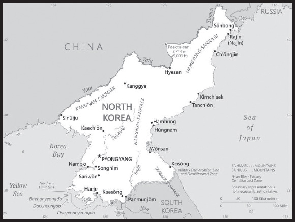
INTRODUCTION
Background: The first recorded kingdom (Choson) on the Korean Peninsula dates from approximately 2300 B.C. Over the subsequent centuries, three main kingdoms - Kogoryo, Paekche, and Silla - were established on the Peninsula. By the 5th century A.D., Kogoryo emerged as the most powerful, with control over much of the Peninsula, as well as part of Manchuria (modern-day northeast China). However, Silla allied with the Chinese to create the first unified Korean state in the late 7th century (688). Following the collapse of Silla in the 9th century, Korea was unified under the Koryo (Goryeo; 918-1392) and the Chosen (Joseon; 1392-1910) dynasties. Korea became the object of intense imperialistic rivalry between the Chinese (its traditional benefactor), Japanese, and Russian empires in the latter half of the 19th and early 20th centuries. Following the Sino-Japanese War (1894-95) and the Russo-Japanese War (1904-05), Korea was occupied by Imperial Japan. In 1910, Japan formally annexed the entire peninsula. After World War II, Korea was split along the 38th parallel with the northern half coming under Soviet-sponsored communist control.
In 1948, North Korea (formally known as the Democratic People’s Republic of Korea or DPRK) was founded under President KIM Il Sung, who consolidated power and cemented autocratic one-party rule under the Korean Worker’s Party (KWP). After the Korean War (1950-53), during which North Korea failed to conquer UN-backed South Korea (formally the Republic of Korea or ROK), North Korea demonized the US as the ultimate threat to its social system through state-funded propaganda and molded political, economic, and military policies around the core ideological objective of eventual unification of Korea under Pyongyang’s control. North Korea also declared a central ideology of juche (“self-reliance”) as an internal check against outside influence while continuing to rely heavily on China and the Soviet Union for economic support. Establishing a policy of hereditary succession in North Korea, KIM Il Sung’s son, KIM Jong Il, was officially designated as his father’s successor in 1980, assuming a growing political and managerial role until the elder KIM’s death in 1994. Under KIM Jong ll’s reign, North Korea continued developing nuclear weapons and ballistic missiles. KIM Jong Un was publicly unveiled as his father’s successor in 2010. Following KIM Jong ll’s death in 2011, KIM Jong Un quickly assumed power and has since occupied the regime’s highest political and military posts.
After the end of Soviet aid in 1991, North Korea faced serious economic setbacks that exacerbated decades of economic mismanagement and resource misallocation. Since the mid-1990s, North Korea has faced chronic food shortages and economic stagnation. In recent years, the North’s domestic agricultural production has improved, but still falls far short of producing sufficient food to provide for its entire population. Starting in 2002, North Korea began to tolerate semi-private markets but has made few other efforts to meet its goal of improving the overall standard of living. New economic development plans in the 2010s failed to meet government-mandated goals for key industrial sectors, food production, or overall economic performance. At the onset of the COVID-19 pandemic in early 2020, North Korea instituted a nationwide lockdown that severely restricted its economy and international engagement. Since then, leader KIM Jong Un has repeatedly expressed concerns with the regime’s economic failures and food problems, but in 2021 vowed to continue “self-reliant” policies and has reinvigorated his pursuit of greater regime control of the economy. As of 2023, despite slowly renewing cross-border trade, North Korea remains one of the World’s most isolated and one of Asia’s poorest countries.
North Korea has a history of provocative regional military actions and posturing that are of major concern to the international community and have limited North Korea’s international engagement, particularly economically. These include proliferation of military-related items; ballistic and cruise missile development and testing; WMD programs including tests of nuclear devices in 2006, 2009, 2013, 2016, and 2017; and large conventional armed forces. Despite high-level efforts to ease tensions during the 2018-19 timeframe, including summits with the leaders of China, South Korea, and the US, North Korea has continued developing its WMD programs and, in recent years, issued statements condemning the US and vowing to further strengthen its military capabilities, including long range missiles and nuclear weapons.
GEOGRAPHY
Location: Eastern Asia, northern half of the Korean Peninsula bordering the Korea Bay and the Sea of Japan, between China and South Korea
Geographic coordinates: 40 00 N, 127 00 E
Map references: Asia
Area: total: 120,538 sq km
land: 120,408 sq km
water: 130 sq km
comparison ranking: total 99
Area - comparative: slightly larger than Virginia; slightly smaller than Mississippi
Land boundaries: total: 1,607 km
border countries (3): China 1,352 km; South Korea 237 km; Russia 18 km
Coastline: 2,495 km
Maritime claims: territorial sea: 12 nm
exclusive economic zone: 200 nm
note: military boundary line 50 nm in the Sea of Japan and the exclusive economic zone limit in the Yellow Sea where all foreign vessels and aircraft without permission are banned
Climate: temperate, with rainfall concentrated in summer; long, bitter winters
Terrain: mostly hills and mountains separated by deep, narrow valleys; wide coastal plains in west, discontinuous in east
Elevation: highest point: Paektu-san 2,744 m
lowest point: Sea of Japan 0 m
mean elevation: 600 m
Natural resources: coal, iron ore, limestone, magnesite, graphite, copper, zinc, lead, precious metals, hydropower
Land use: agricultural land: 21.8% (2018 est.)
arable land: 19.5% (2018 est.)
permanent crops: 1.9% (2018 est.)
permanent pasture: 0.4% (2018 est.)
forest: 46% (2018 est.)
other: 32.2% (2018 est.)
Irrigated land: 14,600 sq km (2012)
Population distribution: population concentrated in the plains and lowlands; least populated regions are the mountainous provinces adjacent to the Chinese border; largest concentrations are in the western provinces, particularly the municipal district of Pyongyang, and around Hungnam and Wonsan in the east
Natural hazards: late spring droughts often followed by severe flooding; occasional typhoons during the early fall
volcanism: P’aektu-san (2,744 m) (also known as Baitoushan, Baegdu, or Changbaishan), on the Chinese border, is considered historically active
Geography - note: strategic location bordering China, South Korea, and Russia; mountainous interior is isolated and sparsely populated
PEOPLE AND SOCIETY
Population: 26,072,217 (2023 est.)
comparison ranking: 55
Nationality: noun: Korean(s)
adjective: Korean
Ethnic groups: racially homogeneous; there is a small Chinese community and a few ethnic Japanese
Languages: Korean
major-language sample(s):

(Korean)
Religions: traditionally Buddhist and Confucian, some Christian and syncretic Chondogyo (Religion of the Heavenly Way)
note: autonomous religious activities now almost nonexistent; government-sponsored religious groups exist to provide illusion of religious freedom
Age structure: 0-14 years: 20.24% (male 2,696,287/female 2,580,346)
15-64 years: 69.16% (male 8,992,254/female 9,040,025)
65 years and over: 10.6% (2023 est.) (male 992,424/female 1,770,881)
Dependency ratios: total dependency ratio: 43.5
youth dependency ratio: 27.2
elderly dependency ratio: 16.3
potential support ratio: 6.1 (2021 est.)
Median age: total: 34.6 years (2020)
male: 33.2 years
female: 36.2 years
comparison ranking: total 89
Population growth rate: 0.44% (2023 est.)
comparison ranking: 158
Birth rate: 14.06 births/1,000 population (2023 est.)
comparison ranking: 120
Death rate: 9.66 deaths/1,000 population (2023 est.)
comparison ranking: 39
Net migration rate: -0.04 migrant(s)/1,000 population (2023 est.)
comparison ranking: 100
Population distribution: population concentrated in the plains and lowlands; least populated regions are the mountainous provinces adjacent to the Chinese border; largest concentrations are in the western provinces, particularly the municipal district of Pyongyang, and around Hungnam and Wonsan in the east
Urbanization: urban population: 63.2% of total population (2023)
rate of urbanization: 0.85% annual rate of change (2020-25 est.)
Major urban areas - population: 3.158 million PYONGYANG (capital) (2023)
Sex ratio: at birth: 1.06 male(s)/female
0-14 years: 1.04 male(s)/female
15-64 years: 0.99 male(s)/female
65 years and over: 0.56 male(s)/female
total population: 0.95 male(s)/female (2023 est.)
Maternal mortality ratio: 107 deaths/100,000 live births (2020 est.)
comparison ranking: 66
Infant mortality rate: total: 22 deaths/1,000 live births (2023 est.)
male: 24.85 deaths/1,000 live births
female: 18.99 deaths/1,000 live births
comparison ranking: total 74
Life expectancy at birth: total population: 71.88 years (2023 est.)
male: 67.97 years
female: 76.02 years
comparison ranking: total population 165
Total fertility rate: 1.89 children born/woman (2023 est.)
comparison ranking: 127
Gross reproduction rate: 0.92 (2023 est.)
Contraceptive prevalence rate: 70.2% (2017)
Drinking water source: improved: urban: 97.8% of population
rural: 89.1% of population
total: 94.5% of population
unimproved: urban: 2.2% of population
rural: 10.9% of population
total: 5.5% of population (2020 est.)
Physicians density: 3.68 physicians/1,000 population (2017)
Sanitation facility access: improved: urban: 92.7% of population
rural: 73.1% of population
total: 85.3% of population
unimproved: urban: 7.3% of population
rural: 26.9% of population
total: 14.7% of population (2020 est.)
Obesity - adult prevalence rate: 6.8% (2016)
comparison ranking: 163
Alcohol consumption per capita: total: 3.61 liters of pure alcohol (2019 est.)
beer: 0.12 liters of pure alcohol (2019 est.)
wine: 0 liters of pure alcohol (2019 est.)
spirits: 3.48 liters of pure alcohol (2019 est.)
other alcohols: 0 liters of pure alcohol (2019 est.)
comparison ranking: total 102
Tobacco use: total: 17.4% (2020 est.)
male: 34.8% (2020 est.)
female: 0% (2020 est.)
comparison ranking: total 98
Children under the age of 5 years underweight: 9.3% (2017)
comparison ranking: 60
Currently married women (ages 15-49): 69.7% (2023 est.)
Child marriage: women married by age 18: 0.1% (2017 est.)
Literacy: definition: age 15 and over can read and write
total population: 100%
male: 100%
female: 100% (2015)
School life expectancy (primary to tertiary education): total: 11 years
male: 11 years
female: 11 years (2015)
Youth unemployment rate (ages 15-24): total: 6.1% (2021 est.)
male: 5.4%
female: 6.9%
comparison ranking: total 182
ENVIRONMENT
Environment - current issues: water pollution; inadequate supplies of potable water; waterborne disease; deforestation; soil erosion and degradation
Environment - international agreements: party to: Antarctic Treaty, Biodiversity, Climate Change, Climate Change-Kyoto Protocol, Climate Change-Paris Agreement, Desertification, Environmental Modification, Hazardous Wastes, Ozone Layer Protection, Ship Pollution, Wetlands
signed, but not ratified: Antarctic-Environmental Protection, Law of the Sea
Climate: temperate, with rainfall concentrated in summer; long, bitter winters
Land use: agricultural land: 21.8% (2018 est.)
arable land: 19.5% (2018 est.)
permanent crops: 1.9% (2018 est.)
permanent pasture: 0.4% (2018 est.)
forest: 46% (2018 est.)
other: 32.2% (2018 est.)
Urbanization: urban population: 63.2% of total population (2023)
rate of urbanization: 0.85% annual rate of change (2020-25 est.)
Food insecurity: widespread lack of access: due to low food consumption levels, poor dietary diversity, and economic downturn - a large portion of the population suffers from low levels of food consumption and very poor dietary diversity; the economic constraints, particularly resulting from the global impact of the COVID-19 pandemic, have increased the population’s vulnerability to food insecurity; the food gap is estimated at about 860,000 mt, equivalent to approximately 2-3 months of food use, if this gap is not adequately covered through commercial imports and/or food aid, households could experience a harsh lean period (2022)
Air pollutants: particulate matter emissions: 41.46 micrograms per cubic meter (2019 est.)
carbon dioxide emissions: 28.28 megatons (2016 est.)
methane emissions: 18.68 megatons (2020 est.)
Total water withdrawal: municipal: 900 million cubic meters (2020 est.)
industrial: 1.15 billion cubic meters (2020 est.)
agricultural: 6.61 billion cubic meters (2020 est.)
Total renewable water resources: 77.15 billion cubic meters (2020 est.)
GOVERNMENT
Country name: conventional long form: Democratic People’s Republic of Korea
conventional short form: North Korea
local long form: Choson-minjujuui-inmin-konghwaguk
local short form: Choson
abbreviation: DPRK
etymology: derived from the Chinese name for Goryeo, which was the Korean dynasty that united the peninsula in the 10th century A.D.; the North Korean name “Choson” means “[Land of the] Morning Calm”
Government type: dictatorship, single-party state; official state ideology of “Juche” or “national self-reliance”
Capital: name: Pyongyang
geographic coordinates: 39 01 N, 125 45 E
time difference: UTC+9 (14 hours ahead of Washington, DC, during Standard Time)
time zone note: on 5 May 2018, North Korea reverted to UTC+9, the same time zone as South Korea
etymology: the name translates as “flat land” in Korean
Administrative divisions: 9 provinces (do, singular and plural) and 4 special administration cities (si, singular and plural)
provinces: Chagang, Hambuk (North Hamgyong), Hamnam (South Hamgyong), Hwangbuk (North Hwanghae), Hwangnam (South Hwanghae), Kangwon, P’yongbuk (North Pyongan), P’yongnam (South Pyongan), Ryanggang
special administration cities: Kaesong, Nampo, P’yongyang, Rason
note: P’yongyang is identified as a directly controlled city, while Kaesong, Nampo, and Rason are designated as special cities
Independence: 15 August 1945 (from Japan)
National holiday: Founding of the Democratic People’s Republic of Korea (DPRK), 9 September (1948)
Constitution: history: previous 1948, 1972; latest adopted 1998 (during KIM Jong-il era)
amendments: proposed by the Supreme People’s Assembly (SPA); passage requires more than two-thirds majority vote of the total SPA membership; revised several times, last in 2019
Legal system: civil law system based on the Prussian model; system influenced by Japanese traditions and Communist legal theory
International law organization participation: has not submitted an ICJ jurisdiction declaration; non-party state to the ICCt
Citizenship: citizenship by birth: no
citizenship by descent only: at least one parent must be a citizen of North Korea
dual citizenship recognized: no
residency requirement for naturalization: unknown
Suffrage: 17 years of age; universal and compulsory
Executive branch: chief of state: State Affairs Commission President KIM Jong Un (since 17 December 2011); note - within the North Korean system, KIM Jong Un’s role as chief of state is secondary to his role as general secretary of the Korean Workers’ Party; chief of state is used to engage with non-communist countries such as the US; North Korea revised its constitution in 2019 to define “the Chairman of the State Affairs Commission” as “the supreme leader who represents the state”; functions as the commander-in-chief and chief executive; the specific titles associated with this office have changed multiple times under KIM’s tenure, however, KIM Jong Un has been supreme leader since his father’s death in 2011
head of government: Supreme People’s Assembly President CHOE Ryong Hae (since 11 April 2019); note - functions as the technical head of state and performs related duties, such as receiving ambassadors’ credentials
cabinet: Cabinet or Naegak members appointed by the Supreme People’s Assembly except the Minister of People’s Armed Forces
elections/appointments: chief of state and premier indirectly elected by the Supreme People’s Assembly; election last held on 10 March 2019 (next to be held in March 2024)
election results: KIM Jong Un reelected unopposed
note 1: KIM Jong Un’s titles include general secretary of the Workers’ Party of Korea (KWP), chairman of the KWP Central Military Commission, president of the State Affairs Commission, and supreme commander of the Korean People’s Army
Legislative branch: description: unicameral Supreme People’s Assembly or Ch’oego Inmin Hoeui (687 seats; members directly elected by majority vote in 2 rounds if needed to serve 5-year terms); note - functions as a rubberstamp legislature; the Korean Workers’ Party selects all candidates
elections: last held on 10 March 2019 (next to be held in March 2024)
election results: percent of vote by party - NA; seats by party - KWP 607, KSDP 50, Chondoist Chongu Party 22, General Association of Korean Residents in Japan (Chongryon) 5, religious associations 3; ruling party approves a list of candidates who are elected without opposition; composition as of March 2022 - men 566, women 121, percent of women 17.6%
note: KWP, KSDP, Chondoist Chongu Party, and Chongryon are under the KWP’s control; a token number of seats reserved for minor parties
Judicial branch: highest court(s): Supreme Court or Central Court (consists of one judge and 2 “People’s Assessors” or, for some cases, 3 judges)
judge selection and term of office: judges elected by the Supreme People’s Assembly for 5-year terms
subordinate courts: lower provincial courts as determined by the Supreme People’s Assembly
Political parties and leaders: major parties: Korean Workers’ Party or KWP (formally known as Workers’ Party of Korea) [KIM Jong Un, general secretary]
General Association of Korean Residents in Japan (Chongryon) [HO Chong Man]
minor parties: Chondoist Chongu Party [RI Myong Chol] (under KWP control)
Social Democratic Party or KSDP [PAK Yong Il] (under KWP control)
International organization participation: ARF, FAO, G-77, ICAO, ICRM, IFAD, IFRCS, IHO, IMO, IMSO, IOC, IPU, ISO, ITSO, ITU, NAM, UN, UNCTAD, UNESCO, UNIDO, UNWTO, UPU, WFTU (NGOs), WHO, WIPO, WMO
Diplomatic representation in the US: chief of mission: none; North Korea has a Permanent Mission to the UN in New York
Diplomatic representation from the US: embassy: none; the Swedish Embassy in Pyongyang represents the US as consular protecting power
Flag description: three horizontal bands of blue (top), red (triple width), and blue; the red band is edged in white; on the hoist side of the red band is a white disk with a red five-pointed star; the broad red band symbolizes revolutionary traditions; the narrow white bands stand for purity, strength, and dignity; the blue bands signify sovereignty, peace, and friendship; the red star represents socialism
National symbol(s): red star, chollima (winged horse); national colors: red, white, blue
National anthem: name: “Aegukka” (Patriotic Song)
lyrics/music: PAK Se Yong/KIM Won Gyun
note: adopted 1947; both North Korea’s and South Korea’s anthems share the same name and have a vaguely similar melody but have different lyrics; the North Korean anthem is also known as “Ach’imun pinnara” (Let Morning Shine)
National heritage: total World Heritage Sites: 2 (both cultural)
selected World Heritage Site locales: Koguryo Tombs Complex; Historic Monuments and Sites in Kaesong
ECONOMY
Economic overview: one of the last centrally planned economies; hard hit by COVID-19, crop failures, international sanctions, and isolationist policies; declining growth and trade, and heavily reliant on China; poor exchange rate stability; economic data integrity issues
Real GDP (purchasing power parity): $40 billion (2015 est.)
$40 billion (2014 est.)
$40 billion (2013 est.)
note: data are in 2015 US dollars
North Korea does not publish reliable National Income Accounts data; the data shown are derived from purchasing power parity (PPP) GDP estimates that were made by Angus MADDISON in a study conducted for the OECD; his figure for 1999 was extrapolated to 2015 using estimated real growth rates for North Korea’s GDP and an inflation factor based on the US GDP deflator; the results were rounded to the nearest $10 billion.
comparison ranking: 121
Real GDP growth rate: -1.1% (2015 est.)
1% (2014 est.)
1.1% (2013 est.)
comparison ranking: 199
Real GDP per capita: $1,700 (2015 est.)
$1,800 (2014 est.)
$1,800 (2013 est.)
note: data are in 2015 US dollars
comparison ranking: 215
GDP (official exchange rate): $28 billion (2013 est.)
GDP - composition, by sector of origin: agriculture: 22.5% (2017 est.)
industry: 47.6% (2017 est.)
services: 29.9% (2017 est.)
comparison rankings: services 224; industry 15; agriculture 38
GDP - composition, by end use: exports of goods and services: 5.9% (2016 est.)
imports of goods and services: -11.1% (2016 est.)
Agricultural products: rice, maize, vegetables, apples, potatoes, cabbages, fruit, sweet potatoes, beans, soybeans
Industries: military products; machine building, electric power, chemicals; mining (coal, iron ore, limestone, magnesite, graphite, copper, zinc, lead, and precious metals), metallurgy; textiles, food processing; tourism
Industrial production growth rate: 1% (2017 est.)
comparison ranking: 151
Labor force: 17.16 million (2021 est.)
note: estimates vary widely
comparison ranking: 36
Labor force - by occupation: agriculture: 37%
industry: 63% (2008 est.)
Unemployment rate: 2.59% (2021 est.)
2.92% (2020 est.)
2.59% (2019 est.)
comparison ranking: 204
Youth unemployment rate (ages 15-24): total: 6.1% (2021 est.)
male: 5.4%
female: 6.9%
comparison ranking: total 182
Budget: revenues: $3.2 billion (2007 est.)
expenditures: $3.3 billion (2007 est.)
Budget surplus (+) or deficit (-): -0.4% (of GDP) (2007 est.)
comparison ranking: 58
Taxes and other revenues: 11.4% (of GDP) (2007 est.)
note: excludes earnings from state-operated enterprises
comparison ranking: 182
Fiscal year: calendar year
Exports: $222 million (2018)
$4.582 billion (2017 est.)
$2.908 billion (2015 est.)
comparison ranking: 200
Exports - partners: China 67%, Suriname 6% (2019)
Exports - commodities: refined petroleum, iron alloys, electricity, cars, vaccines and cultures (2021)
Imports: $2.32 billion (2018 est.)
$3.86 billion (2016 est.)
comparison ranking: 167
Imports - partners: China 96% (2019)
Imports - commodities: clothing and apparel, soybean oil, rice, wheat products, clocks/watches (2019)
Debt - external: $5 billion (2013 est.)
comparison ranking: 132
Exchange rates: North Korean won (KPW) per US dollar (average market rate)
Exchange rates: 135 (2017 est.)
130 (2016 est.)
130 (2015 est.)
98.5 (2013 est.)
155.5 (2012 est.)
ENERGY
Electricity access: population without electricity: 19 million (2020)
electrification - total population: 52.6% (2021)
electrification - urban areas: 36% (2020)
electrification - rural areas: 11% (2020)
Electricity: installed generating capacity: 8.413 million kW (2020 est.)
consumption: 13,930,320,000 kWh (2019 est.)
exports: 0 kWh (2020 est.)
imports: 0 kWh (2020 est.)
transmission/distribution losses: 2.146 billion kWh (2019 est.)
comparison rankings: imports 191; exports 186; installed generating capacity 72; transmission/distribution losses 86; consumption 84
Electricity generation sources: fossil fuels: 15.8% of total installed capacity (2020 est.)
solar: 0.1% of total installed capacity (2020 est.)
hydroelectricity: 84.1% of total installed capacity (2020 est.)
Coal: production: 16.376 million metric tons (2020 est.)
consumption: 6.698 million metric tons (2020 est.)
exports: 0 metric tons (2020 est.)
imports: 22,000 metric tons (2020 est.)
proven reserves: 600 million metric tons (2019 est.)
Petroleum: total petroleum production: 0 bbl/day (2021 est.)
refined petroleum consumption: 20,300 bbl/day (2019 est.)
crude oil and lease condensate exports: 0 bbl/day (2018 est.)
crude oil and lease condensate imports: 10,600 bbl/day (2018 est.)
crude oil estimated reserves: 0 barrels (2021 est.)
Refined petroleum products - production: 11,270 bbl/day (2015 est.)
comparison ranking: 99
Refined petroleum products - exports: 0 bbl/day (2015 est.)
comparison ranking: 156
Refined petroleum products - imports: 8,260 bbl/day (2015 est.)
comparison ranking: 151
Carbon dioxide emissions: 18.465 million metric tonnes of CO2 (2019 est.)
from coal and metallurgical coke: 15.252 million metric tonnes of CO2 (2019 est.)
from petroleum and other liquids: 3.213 million metric tonnes of CO2 (2019 est.)
comparison ranking: total emissions 87
Energy consumption per capita: 12.61 million Btu/person (2019 est.)
comparison ranking: 146
COMMUNICATIONS
Telephones - fixed lines: total subscriptions: 1.2 million (2021 est.)
subscriptions per 100 inhabitants: 5 (2021 est.)
comparison ranking: total subscriptions 67
Telephones - mobile cellular: total subscriptions: 6 million (2021 est.)
subscriptions per 100 inhabitants: 23 (2021 est.)
comparison ranking: total subscriptions 118
Telecommunication systems: general assessment: despite years of isolationism, economic under-achievement, and international sanctions, North Korea has improved its telecommunications infrastructure in the last decade; Inconsistent electric power supply and likely difficulties procuring new hardware, however, present enduring obstacles to building reliable high-speed telecom networks; mobile phone use is estimated to have increased to nearly 25% of the polulation as of 2018, yet the high cost of ownership makes mobile communications inaccessible to North Koreans of lower socioeconomic status; strict regime censorship and monitoring of telecom systems in North Korea restricts users from legally contacting anyone outside the country or accessing the global Internet; for those citizens living close to China, it has been possible to illegally obtain Chinese handsets and SIM cards, and to connect to towers located just across the border; while this offers access to the outside world and at much lower prices than the state-controlled offerings, the risks are high including steep fines and the possibility of jail time; North Korea has been effective in building an IT sector and a nascent digital economy on the back of a concerted effort to grow a sizeable, well-trained IT workforce; but even here, its capabilities have been directed more towards nefarious activities such as cyber crime and hacking into foreign countries’ computer and financial systems; North Korea’s determination to maintain ideological control of its populace by isolating itself from the rest of the world will probably lead to tighter controls on communications inside and outside of the country (2023)
domestic: fixed-lines are approximately 5 per 100 and mobile-cellular 23 per 100 persons (2021)
international: country code - 850; satellite earth stations - 2 (1 Intelsat - Indian Ocean, 1 Russian - Indian Ocean region); other international connections through Moscow and Beijing
Broadcast media: no independent media; radios and TVs are pre-tuned to government stations; 4 government-owned TV stations; the Korean Workers’ Party owns and operates the Korean Central Broadcasting Station, and the state-run Voice of Korea operates an external broadcast service; the government prohibits listening to and jams foreign broadcasts (2019)
Internet country code: .kp
TRANSPORTATION
National air transport system: number of registered air carriers: 1 (2020)
inventory of registered aircraft operated by air carriers: 4
annual passenger traffic on registered air carriers: 103,560 (2018)
annual freight traffic on registered air carriers: 250,000 (2018) mt-km
Civil aircraft registration country code prefix: P
Airports: 82 (2021)
comparison ranking: total 67
Airports - with paved runways: 39
note: paved runways have a concrete or asphalt surface but not all have facilities for refueling, maintenance, or air traffic control; the length of a runway required for aircraft to safely operate depends on a number of factors including the type of aircraft, the takeoff weight (including passengers, cargo, and fuel), engine types, flap settings, landing speed, elevation of the airport, and average maximum daily air temperature; paved runways can reach a length of 5,000 m (16,000 ft.), but the “typical” length of a commercial airline runway is between 2,500-4,000 m (8,000-13,000 ft.)
Airports - with unpaved runways: 43
note: unpaved runways have a surface composition such as grass or packed earth and are most suited to the operation of light aircraft; unpaved runways are usually short, often less than 1,000 m (3,280 ft.) in length; airports with unpaved runways often lack facilities for refueling, maintenance, or air traffic control
Heliports: 23 (2021)
Pipelines: 6 km oil (2013)
Railways: total: 7,435 km (2014)
standard gauge: 7,435 km (2014) 1.435-m gauge (5,400 km electrified)
note: figures are approximate; some narrow-gauge railway also exists
comparison ranking: total 29
Roadways: total: 25,554 km (2006)
paved: 724 km (2006)
unpaved: 24,830 km (2006)
comparison ranking: total 103
Waterways: 2,250 km (2011) (most navigable only by small craft)
comparison ranking: 40
Merchant marine: total: 270 (2022)
by type: bulk carrier 9, container ship 5, general cargo 193, oil tanker 33, other 30
comparison ranking: total 59
Ports and terminals: major seaport(s): Ch’ongjin, Haeju, Hungnam, Namp’o, Songnim, Sonbong (formerly Unggi), Wonsan
MILITARY AND SECURITY
Military and security forces: Korean People’s Army (KPA): KPA Ground Forces, KPA Navy, KPA Air Force and Air Defense Forces, KPA Strategic Forces (missile forces), KPA Special Forces (special operations forces); Security Guard Command (aka Bodyguard Command); Military Security Command
Ministry of Social Security (formerly Ministry of Public Security): Border Guard General Bureau, civil security forces; Ministry of State Security: internal security, investigations (2023)
note 1: North Korea employs a systematic and intentional overlap of powers and responsibilities among its multiple internal security organizations to prevent any potential subordinate consolidation of power and assure that each unit provided a check and balance on the other
note 2: the Security Guard Command protects the Kim family, other senior leadership figures, and government facilities
note 3: the North also has a large paramilitary/militia force organized into the Worker Peasant Red Guard and Red Youth Guard; these organizations are present at all levels of government (province, county, ward) and are under the control of the Korean Workers’ Party in peacetime, but revert to KPA control in crisis or war; they are often mobilized for domestic projects, such as road building and agricultural support
Military expenditures: between 2010 and 2019, military expenditures accounted for an estimated 20-25% of North Korea’s GDP annually; in 2023, North Korea announced that it would spend nearly 16% of state expenditures on defense; North Korea in the 2010s and 2020s has increasingly relied on illicit activities — including cybercrime — to generate revenue for its weapons of mass destruction and ballistic missile programs to evade US and UN sanctions
Military and security service personnel strengths: information varies; estimated 1-1.2 million active-duty troops; estimated 200,000 internal security forces (2023)
Military equipment inventories and acquisitions: the KPA is equipped with older weapon systems originally acquired from the former Soviet Union, Russia, and China, and some domestically produced equipment; North Korea produces a diverse array of military hardware, including small arms, munitions, light armored vehicles, tanks, naval vessels and submarines, and some advanced weapons systems, such as cruise and ballistic missiles; most are copies or upgrades of older foreign supplied equipment (2023)
note: since 2006, the UN Security Council has passed nearly a dozen resolutions sanctioning North Korea for developing nuclear weapons and related activities, starting with Resolution 1718, which condemned the North’s first nuclear test and placed sanctions on the supply of heavy weaponry (including tanks, armored combat vehicles, large calibre artillery, combat aircraft, attack helicopters, warships, and missiles and missile launchers), missile technology and material, and select luxury goods; additional resolutions have expanded to include all arms, including small arms and light weapons; the US and other countries have also imposed unilateral sanctions
Military service age and obligation: 17 years of age for compulsory military service for men and women; service obligation varies from 5-13 years; reportedly up to 10 years (7 for women) for those serving in combat units and 13 years (7 for women) for specialized combat units, such as missile forces (2023)
note: the bulk of the KPA is made up of conscripts; as many as 20% of North Korean males between the ages of 16 and 54 are in the military at a given time and possibly up to 30 percent of males between the ages of 18 and 27, not counting the reserves or paramilitary units; women comprise about 20% of the military by some estimates
Military - note: North Korea is one of the most militarized countries in the World, and the Korean People’s Army (KPA) is one of the World’s largest military forces; the KPA’s primary responsibilities are national defense and protection of the Kim regime; it also provides considerable support to domestic economic projects such as agriculture production and infrastructure construction; North Korea views the US as its primary external security threat while South Korea and Japan are treated as extensions of perceived US aggression; the North also sees South Korea’s different economic and political systems as a threat to the regime’s legitimacy; the Kim regime is driven by fears of threats to its power from internal sources as well
in addition to the invasion of South Korea and the subsequent Korean War (1950-53), North Korea from the 1960s to the 1980s launched a considerable number of limited military and subversive actions against South Korea using special forces and terrorist tactics; including aggressive skirmishes along the DMZ, overt attempts to assassinate South Korean leaders, kidnappings, the bombing of an airliner, and a failed effort in 1968 to foment an insurrection and conduct a guerrilla war in the South with more than 100 seaborne commandos; from the 1990s until 2010, the North lost two submarines and a semi-submersible boat attempting to insert infiltrators into the South (1996, 1998) and provoked several engagements in the Northwest Islands area along the disputed Northern Limit Line (NLL), including naval skirmishes between patrol boats in 1999 and 2002, the torpedoing and sinking of a South Korean Navy corvette in 2010, and the bombardment of a South Korean Marine Corps installation on Yeonpyeong Island, also in 2010; since 2010, further minor incidents continue to occur periodically along the DMZ, where both the KPA and the South Korean military maintain large numbers of troops
the KPA was founded in 1948; Kim Jong Un is the KPA supreme commander, while operational control of the armed forces resides in the General Staff Department (GSD), which reports directly to Kim; the GSD maintains overall control of all military forces and is charged with turning Kim’s directives into operational military orders; the Ministry of National Defense (MND) is responsible for administrative control of the military and external relations with foreign militaries
North Korea’s growing ballistic missile program includes close- (CRBM), short- (SRBM), medium- (MRBM), intermediate- (IRBM), and intercontinental- (ICBM) range ballistic missiles; the North received its first ballistic missiles, short-range FROGs (free rocket over ground), from the Soviet Union in the 1960s, but its modern ballistic missile program is generally thought to date back to the mid-1970s when it received a Soviet Scud-class missile, likely from Egypt; the North reverse-engineered the missile and developed an indigenously built version in 1984; it flight-tested its first Scud-based medium-range Nodong missile in 1990, and probably began development of the multi-stage Taepodong missiles around this time as well; the North revealed its first road-mobile ICBM in 2012 and conducted the first test of an ICBM-class system in 2017; it conducted additional ICBM tests in 2022 and 2023 (2023)
SPACE
Space agency/agencies: National Aerospace Development Administration (NADA; established 2013); predecessor organization, Korean Committee of Space Technology (KCST; established 1980s); State Space Development Bureau; Academy of Defense Science; Ministry of People’s Armed Forces (2023)
Space launch site(s): Sohae Satellite Launching Station (aka Tongch’ang-dong Space Launch Center; North Pyongan province); Tonghae Satellite Launching Ground (North Hamgyong province) (2023)
Space program overview: North Korea’s leader has emphasized the development of space capabilities, particularly space launch vehicles (SLVs) and remote sensing (RS) satellites; manufactures small satellites; manufactures and launches rockets/SLVs; note – the SLV program is closely related to North Korea’s development of intercontinental ballistic missiles (2023)
note: further details about the key activities, programs, and milestones of the country’s space program, as well as government spending estimates on the space sector, appear in Appendix S
TRANSNATIONAL ISSUES
Disputes - international: North Korea-China: risking arrest, imprisonment, and deportation, tens of thousands of North Koreans cross into China to escape famine, economic privation, and political oppression; North Korea and China dispute the sovereignty of certain islands in Yalu and Tumen Rivers
North Korea-Japan: North Korea supports South Korea in rejecting Japan’s claim to Liancourt Rocks (Tok-do/Take-shima)
North Korea-South Korea: Military Demarcation Line within the 4-km-wide Demilitarized Zone has separated North from South Korea since 1953; periodic incidents in the Yellow Sea with South Korea which claims the Northern Limiting Line as a maritime boundary
Refugees and internally displaced persons: IDPs: undetermined (2021)
Trafficking in persons: tier rating: Tier 3 — the government of North Korea does not fully meet the minimum standards for the elimination of trafficking and is not making significant efforts to do so; the government did not demonstrate any efforts to address human trafficking; during this reporting period there was a government policy or pattern of human trafficking in prison camps, in labor training centers, in massed mobilizations of adults and children, and through forced labor by North Korean overseas workers; proceeds from state-sponsored forced labor funded government functions and illicit activities (2022)
trafficking profile: human traffickers—including government officials—exploit North Koreans at home and abroad; women and children are exploited in sex trafficking within North Korea; forced labor is part of an established system of political repression and a pillar of the economic system; children in prison camps are subject to forced labor for up to 12 hours per day; officials forcibly mobilize adults and school children to work in factories, agriculture, logging, mining, infrastructure work, information technology, and construction sectors; North Koreans sent to work abroad, including through bilateral agreements with foreign businesses or governments, face forced labor conditions; NGOs report overseas workers are managed as a matter of state policy; the government often appropriates and deposits worker salaries into government-controlled accounts; in 2017, the UN Security Council prohibited members from issuing or renewing work authorizations for North Koreans and, with limited exceptions, required repatriation; nonetheless, an estimated 20,000-100,000 North Koreans are working in China, primarily in restaurants and factories; North Korean women and girls lured by promises of jobs in China are forced into prostitution, marriage, or exploitative labor arrangements; many North Koreans continue to work or enter Russia, and some workers are reportedly working in African, Middle Eastern, an Southeast Asian countries (2022)
Illicit drugs: at present there is insufficient information to determine the current level of involvement of government officials in the production or trafficking of illicit drugs, but for years, from the 1970s into the 2000s, citizens of North Korea, many of them diplomatic employees of the government, were apprehended abroad while trafficking in narcotics; police investigations in Taiwan, Japan and Australia during that period have linked North Korea to large illicit shipments of heroin and methamphetamine