L
INTRODUCTION
Background: Modern-day Laos has its roots in the ancient Lao kingdom of Lan Xang, established in the 14th century under King FA NGUM. For 300 years Lan Xang had influence reaching into present-day Cambodia and Thailand, as well as over all of what is now Laos. After centuries of gradual decline, Laos came under the domination of Siam (Thailand) from the late 18th century until the late 19th century, when it became part of French Indochina. The Franco-Siamese Treaty of 1907 defined the current Lao border with Thailand. In 1975, the communist Pathet Lao took control of the government, ending a six-century-old monarchy and instituting a strict socialist regime closely aligned to Vietnam. A gradual, limited return to private enterprise and the liberalization of foreign investment laws began in 1988. Laos became a member of ASEAN in 1997 and the WTO in 2013.
In the 2010s, the country benefited from direct foreign investment, particularly in the natural resource and industry sectors. Construction of a number of large hydropower dams and expanding mining activities have also boosted the economy. Laos has retained its official commitment to communism and maintains close ties with its two communist neighbors, Vietnam and China, both of which continue to exert substantial political and economic influence on the country. China, for example, provided 70% of the funding for a $5.9 billion, 400-km railway line between the Chinese border and the capital Vientiane, which opened for operations in December 2021. Laos financed the remaining 30% with loans from China. At the same time, Laos has expanded its economic reliance on the West and other Asian countries, such as Japan, Malaysia, Singapore, Taiwan, and Thailand. In 2023, Lao households faced the highest inflation in almost a quarter century, with year-on-year inflation reaching 40% early in the year.
GEOGRAPHY
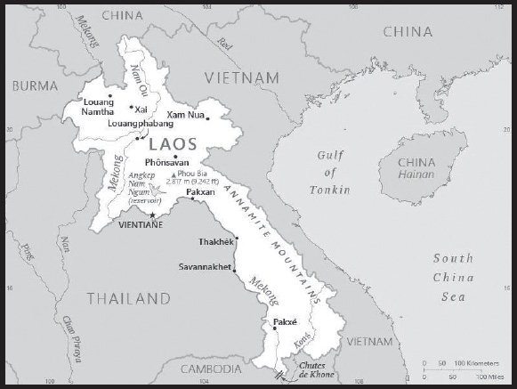
Location: Southeastern Asia, northeast of Thailand, west of Vietnam
Geographic coordinates: 18 00 N, 105 00 E
Map references: Southeast Asia
Area: total: 236,800 sq km
land: 230,800 sq km
water: 6,000 sq km
comparison ranking: total 84
Area - comparative: about twice the size of Pennsylvania; slightly larger than Utah
Land boundaries: total: 5,274 km
border countries (5): Burma 238 km; Cambodia 555 km; China 475 km; Thailand 1,845 km; Vietnam 2,161 km
Coastline: 0 km (landlocked)
Maritime claims: none (landlocked)
Climate: tropical monsoon; rainy season (May to November); dry season (December to April)
Terrain: mostly rugged mountains; some plains and plateaus
Elevation: highest point: Phu Bia 2,817 m
lowest point: Mekong River 70 m
mean elevation: 710 m
Natural resources: timber, hydropower, gypsum, tin, gold, gemstones
Land use: agricultural land: 10.6% (2018 est.)
arable land: 6.2% (2018 est.)
permanent crops: 0.7% (2018 est.)
permanent pasture: 3.7% (2018 est.)
forest: 67.9% (2018 est.)
other: 21.5% (2018 est.)
Irrigated land: 4,409 sq km (2020)
Major rivers (by length in km): Mènam Khong (Mekong) (shared with China [s], Burma, Thailand, Cambodia, and Vietnam [m]) - 4,350 km note – [s] after country name indicates river source; [m] after country name indicates river mouth
Major watersheds (area sq km): Pacific Ocean drainage: Mekong (805,604 sq km)
Population distribution: most densely populated area is in and around the capital city of Vientiane; large communities are primarily found along the Mekong River along the southwestern border; overall density is considered one of the lowest in Southeast Asia
Natural hazards: floods, droughts
Geography - note: landlocked; most of the country is mountainous and thickly forested; the Mekong River forms a large part of the western boundary with Thailand
PEOPLE AND SOCIETY
Population: 7,852,377 (2023 est.)
comparison ranking: 103
Nationality: noun: Lao(s) or Laotian(s)
adjective: Lao or Laotian
Ethnic groups: Lao 53.2%, Khmou 11%, Hmong 9.2%, Phouthay 3.4%, Tai 3.1%, Makong 2.5%, Katong 2.2%, Lue 2%, Akha 1.8%, other 11.6% (2015 est.)
note: the Laos Government officially recognizes 49 ethnic groups, but the total number of ethnic groups is estimated to be well over 200
Languages: Lao (official), French, English, various ethnic languages
major-language sample(s):

(Lao)
Religions: Buddhist 64.7%, Christian 1.7%, none 31.4%, other/not stated 2.1% (2015 est.)
Demographic profile: Laos is a predominantly rural country with a youthful population – almost 55% of the population is under the age of 25. Its progress on health and development issues has been uneven geographically, among ethnic groups, and socioeconomically. Laos has made headway in poverty reduction, with the poverty rate almost halving from 46% in 1992/93 to 22% in 2012/13. Nevertheless, pronounced rural-urban disparities persist, and income inequality is rising. Poverty most affects populations in rural and highland areas, particularly ethnic minority groups.
The total fertility rate (TFR) has decreased markedly from around 6 births per woman on average in 1990 to approximately 2.8 in 2016, but it is still one of the highest in Southeast Asia. TFR is higher in rural and remote areas, among ethnic minority groups, the less-educated, and the poor; it is lower in urban areas and among the more educated and those with higher incomes. Although Laos’ mortality rates have improved substantially over the last few decades, the maternal mortality rate and childhood malnutrition remain at high levels. As fertility and mortality rates continue to decline, the proportion of Laos’ working-age population will increase, and its share of dependents will shrink. The age structure shift will provide Laos with the potential to realize a demographic dividend during the next few decades, if it can improve educational access and quality and gainfully employ its growing working-age population in productive sectors. Currently, Laos primary school enrollment is nearly universal, but the drop-out rate remains problematic. Secondary school enrollment has also increased but remains low, especially for girls.
Laos has historically been a country of emigration and internal displacement due to conflict and a weak economy. The Laos civil war (1953 – 1975) mainly caused internal displacement (numbering in the hundreds of thousands). Following the end of the Vietnam War in 1975, indigenous people in remote, war-struck areas were resettled and more than 300,000 people fled to Thailand to escape the communist regime that took power. The majority of those who sought refuge in Thailand ultimately were resettled in the US (mainly Hmong who fought with US forces), and lesser numbers went to France, Canada, and Australia.
The Laos Government carried out resettlement programs between the mid-1980s and mid-1990s to relocate ethnic minority groups from the rural northern highlands to development areas in the lowlands ostensibly to alleviate poverty, make basic services more accessible, eliminate slash-and-burn agriculture and opium production, integrate ethnic minorities, and control rebel groups (including Hmong insurgents). For many, however, resettlement has exacerbated poverty, led to the loss of livelihoods, and increased food insecurity and mortality rates. As the resettlement programs started to wane in the second half of the 1990s, migration from the northern highlands to urban centers – chiefly the capital Vientiane – to pursue better jobs in the growing manufacturing and service sectors became the main type of relocation. Migration of villagers from the south seeking work in neighboring Thailand also increased. Thailand is the main international migration destination for Laotians because of the greater availability of jobs and higher pay than at home; nearly a million Laotian migrants were estimated to live in Thailand as of 2015.
Age structure: 0-14 years: 30.63% (male 1,218,731/female 1,186,156)
15-64 years: 64.73% (male 2,527,643/female 2,555,029)
65 years and over: 4.65% (2023 est.) (male 169,142/female 195,676)
Dependency ratios: total dependency ratio: 54.7
youth dependency ratio: 48
elderly dependency ratio: 6.7
potential support ratio: 14.8 (2021 est.)
Median age: total: 24 years (2020)
male: 23.7 years
female: 24.4 years
comparison ranking: total 171
Population growth rate: 1.3% (2023 est.)
comparison ranking: 71
Birth rate: 20.35 births/1,000 population (2023 est.)
comparison ranking: 67
Death rate: 6.26 deaths/1,000 population (2023 est.)
comparison ranking: 145
Net migration rate: -1.09 migrant(s)/1,000 population (2023 est.)
comparison ranking: 150
Population distribution: most densely populated area is in and around the capital city of Vientiane; large communities are primarily found along the Mekong River along the southwestern border; overall density is considered one of the lowest in Southeast Asia
Urbanization: urban population: 38.2% of total population (2023)
rate of urbanization: 2.99% annual rate of change (2020-25 est.)
Major urban areas - population: 721,000 VIENTIANE (capital) (2023)
Sex ratio: at birth: 1.04 male(s)/female
0-14 years: 1.03 male(s)/female
15-64 years: 0.99 male(s)/female
65 years and over: 0.86 male(s)/female
total population: 0.99 male(s)/female (2023 est.)
Maternal mortality ratio: 126 deaths/100,000 live births (2020 est.)
comparison ranking: 60
Infant mortality rate: total: 36.56 deaths/1,000 live births (2023 est.)
male: 40.38 deaths/1,000 live births
female: 32.59 deaths/1,000 live births
comparison ranking: total 37
Life expectancy at birth: total population: 68.59 years (2023 est.)
male: 66.95 years
female: 70.31 years
comparison ranking: total population 183
Total fertility rate: 2.3 children born/woman (2023 est.)
comparison ranking: 76
Gross reproduction rate: 1.13 (2023 est.)
Contraceptive prevalence rate: 54.1% (2017)
Drinking water source: improved: urban: 97.1% of population
rural: 84.1% of population
total: 88.8% of population
unimproved: urban: 2.9% of population
rural: 15.9% of population
total: 11.2% of population (2020 est.)
Current health expenditure: 2.7% of GDP (2020)
Physicians density: 0.35 physicians/1,000 population (2020)
Hospital bed density: 1.5 beds/1,000 population (2012)
Sanitation facility access: improved: urban: 100% of population
rural: 72% of population
total: 82.2% of population
unimproved: urban: 0% of population
rural: 28% of population
total: 17.8% of population (2020 est.)
Major infectious diseases: degree of risk: very high (2023)
food or waterborne diseases: bacterial and protozoal diarrhea, hepatitis A, and typhoid fever
vectorborne diseases: dengue fever and malaria
Obesity - adult prevalence rate: 5.3% (2016)
comparison ranking: 179
Alcohol consumption per capita: total: 8.15 liters of pure alcohol (2019 est.)
beer: 3.62 liters of pure alcohol (2019 est.)
wine: 0.07 liters of pure alcohol (2019 est.)
spirits: 4.46 liters of pure alcohol (2019 est.)
other alcohols: 0 liters of pure alcohol (2019 est.)
comparison ranking: total 42
Tobacco use: total: 31.8% (2020 est.)
male: 53.3% (2020 est.)
female: 10.3% (2020 est.)
comparison ranking: total 21
Children under the age of 5 years underweight: 21.1% (2017)
comparison ranking: 13
Currently married women (ages 15-49): 60.1% (2023 est.)
Child marriage: women married by age 15: 7.1%
women married by age 18: 32.7%
men married by age 18: 10.8% (2017 est.)
Education expenditures: 2.3% of GDP (2020 est.)
comparison ranking: 179
Literacy: definition: age 15 and over can read and write
total population: 87.1%
male: 91.4%
female: 81.4% (2021)
School life expectancy (primary to tertiary education): total: 10 years
male: 10 years
female: 10 years (2020)
Youth unemployment rate (ages 15-24): total: 3.3% (2021 est.)
male: 3.4%
female: 3.2%
comparison ranking: total 196
ENVIRONMENT
Environment - current issues: unexploded ordnance; deforestation; soil erosion; loss of biodiversity; water pollution, most of the population does not have access to potable water
Environment - international agreements: party to: Biodiversity, Climate Change, Climate Change-Kyoto Protocol, Climate Change-Paris Agreement, Comprehensive Nuclear Test Ban, Desertification, Endangered Species, Environmental Modification, Hazardous Wastes, Law of the Sea, Nuclear Test Ban, Ozone Layer Protection, Wetlands, Whaling
signed, but not ratified: none of the selected agreements
Climate: tropical monsoon; rainy season (May to November); dry season (December to April)
Land use: agricultural land: 10.6% (2018 est.)
arable land: 6.2% (2018 est.)
permanent crops: 0.7% (2018 est.)
permanent pasture: 3.7% (2018 est.)
forest: 67.9% (2018 est.)
other: 21.5% (2018 est.)
Urbanization: urban population: 38.2% of total population (2023)
rate of urbanization: 2.99% annual rate of change (2020-25 est.)
Revenue from forest resources: 1.48% of GDP (2018 est.)
comparison ranking: 44
Air pollutants: particulate matter emissions: 21.15 micrograms per cubic meter (2019 est.)
carbon dioxide emissions: 17.76 megatons (2016 est.)
methane emissions: 9 megatons (2020 est.)
Waste and recycling: municipal solid waste generated annually: 351,900 tons (2015 est.)
municipal solid waste recycled annually: 35,190 tons (2015 est.)
percent of municipal solid waste recycled: 10% (2015 est.)
Major rivers (by length in km): Mènam Khong (Mekong) (shared with China [s], Burma, Thailand, Cambodia, and Vietnam [m]) - 4,350 km note – [s] after country name indicates river source; [m] after country name indicates river mouth
Major watersheds (area sq km): Pacific Ocean drainage: Mekong (805,604 sq km)
Total water withdrawal: municipal: 130 million cubic meters (2020 est.)
industrial: 170 million cubic meters (2020 est.)
agricultural: 7.05 billion cubic meters (2020 est.)
Total renewable water resources: 333.5 billion cubic meters (2020 est.)
GOVERNMENT
Country name: conventional long form: Lao People’s Democratic Republic
conventional short form: Laos
local long form: Sathalanalat Paxathipatai Paxaxon Lao
local short form: Mueang Lao (unofficial)
abbreviation: Lao PDR
etymology: name means “Land of the Lao [people]”
Government type: communist state
Capital: name: Vientiane (Viangchan)
geographic coordinates: 17 58 N, 102 36 E
time difference: UTC+7 (12 hours ahead of Washington, DC, during Standard Time)
etymology: the meaning in Pali, a Buddhist liturgical language, is “city of sandalwood”
Administrative divisions: 17 provinces (khoueng, singular and plural) and 1 prefecture* (kampheng nakhon); Attapu, Bokeo, Bolikhamxai, Champasak, Houaphan, Khammouan, Louangnamtha, Louangphabang (Luang Prabang), Oudomxai, Phongsali, Salavan, Savannakhet, Viangchan (Vientiane)*, Viangchan, Xaignabouli, Xaisomboun, Xekong, Xiangkhouang
Independence: 19 July 1949 (from France by the Franco-Lao General Convention); 22 October 1953 (Franco-Lao Treaty recognizes full independence)
National holiday: Republic Day (National Day), 2 December (1975)
Constitution: history: previous 1947 (preindependence); latest promulgated 13-15 August 1991
amendments: proposed by the National Assembly; passage requires at least two-thirds majority vote of the Assembly membership and promulgation by the president of the republic; amended 2003, 2015
Legal system: civil law system similar in form to the French system
International law organization participation: has not submitted an ICJ jurisdiction declaration; non-party state to the ICCt
Citizenship: citizenship by birth: no
citizenship by descent only: at least one parent must be a citizen of Laos
dual citizenship recognized: no
residency requirement for naturalization: 10 years
Suffrage: 18 years of age; universal
Executive branch: chief of state: President THONGLOUN Sisoulith (since 22 March 2021); Vice Presidents PANI Yathotou and BOUNTHONG Chitmani (since 22 March 2021)
head of government: Prime Minister SONXAI Siphandon (since 30 December 2022)
cabinet: Council of Ministers appointed by the president and approved by the National Assembly
elections/appointments: president and vice president indirectly elected by the National Assembly for a 5-year term (no term limits); election last held on 22 March 2021 (next to be held in March 2026); prime minister nominated by the president, elected by the National Assembly for 5-year term
election results:
2021: THONGLOUN Sisoulith elected president; National Assembly vote - THONGLOUN Sisoulith (LPRP161-1; PANI Yathotou and BOUNTHONG Chitmani (LPRP) elected vice presidents; National Assembly vote - NA; PHANKHAM Viphavan (LPRP) elected prime minister; National Assembly vote - 158-3
2016: BOUNNYANG Vorachit (LPRP) elected president; PHANKHAM Viphavan (LPRP) elected vice president; percent of National Assembly vote - NA; THONGLOUN Sisoulith (LPRP) elected prime minister; percent of National Assembly vote - NA
Legislative branch: description: unicameral National Assembly or Sapha Heng Xat (164 seats; members directly elected in multi-seat constituencies by simple majority vote from candidate lists provided by the Lao People’s Revolutionary Party; members serve 5-year terms)
elections: last held on 21 February 2021 (next to be held in 2026)
election results: percent of vote by party - NA; seats by party - LPRP 158, independent 6; composition - men 128, women 36, percent of women 21.9%
Judicial branch: highest court(s): People’s Supreme Court (consists of the court president and organized into criminal, civil, administrative, commercial, family, and juvenile chambers, each with a vice president and several judges)
judge selection and term of office: president of People’s Supreme Court appointed by the National Assembly upon the recommendation of the president of the republic for a 5-year term; vice presidents of the People’s Supreme Court appointed by the president of the republic upon the recommendation of the National Assembly; appointment of chamber judges NA; tenure of court vice presidents and chamber judges NA
subordinate courts: appellate courts; provincial, municipal, district, and military courts
Political parties and leaders: Lao People’s Revolutionary Party or LPRP [THONGLOUN Sisoulit]
note: other parties proscribed
International organization participation: ADB, ARF, ASEAN, CP, EAS, FAO, G-77, IAEA, IBRD, ICAO, ICRM, IDA, IFAD, IFC, IFRCS, ILO, IMF, Interpol, IOC, IPU, ISO (subscriber), ITU, MIGA, NAM, OIF, OPCW, PCA, UN, UNCTAD, UNESCO, UNIDO, UNWTO, UPU, WCO, WFTU (NGOs), WHO, WIPO, WMO, WTO
Diplomatic representation in the US: chief of mission: Ambassador Sisavath INPHACHANH (since 7 June 2022)
chancery: 2222 S Street NW, Washington, DC 20008
telephone: [1] (202) 332-6416
FAX: [1] (202) 332-4923
email address and website:
consulate(s): New York
Diplomatic representation from the US: chief of mission: Ambassador (vacant); Chargée d’Affaires Michelle OUTLAW (since August 2023)
embassy: Ban Somvang Tai, Thadeua Road, Km 9, Hatsayfong District, Vientiane
mailing address: 4350 Vientiane Place, Washington DC 20521-4350
telephone: [856] 21-48-7000
FAX: [856] 21-48-7040
email address and website:
Flag description: three horizontal bands of red (top), blue (double width), and red with a large white disk centered in the blue band; the red bands recall the blood shed for liberation; the blue band represents the Mekong River and prosperity; the white disk symbolizes the full moon against the Mekong River, but also signifies the unity of the people under the Lao People’s Revolutionary Party, as well as the country’s bright future
National symbol(s): elephant; national colors: red, white, blue
National anthem: name: “Pheng Xat Lao” (Hymn of the Lao People)
lyrics/music: SISANA Sisane/THONGDY Sounthonevichit
note: music adopted 1945, lyrics adopted 1975; the anthem’s lyrics were changed following the 1975 Communist revolution that overthrew the monarchy
National heritage: total World Heritage Sites: 3 (all cultural)
selected World Heritage Site locales: Town of Luangphrabang; Vat Phou and Associated Ancient Settlements; Megalithic Jar Sites in Xiengkhuang - Plain of Jars
ECONOMY
Economic overview: lower middle-income, socialist Southeast Asian economy; one of the fastest growing economies; declining but still high poverty; natural resource rich; new anticorruption efforts; already high and growing public debt; service sector hit hard by COVID-19
Real GDP (purchasing power parity): $58.264 billion (2021 est.)
$56.827 billion (2020 est.)
$56.543 billion (2019 est.)
note: data are in 2017 dollars
comparison ranking: 108
Real GDP growth rate: 2.53% (2021 est.)
0.5% (2020 est.)
5.46% (2019 est.)
comparison ranking: 154
Real GDP per capita: $7,800 (2021 est.)
$7,800 (2020 est.)
$7,800 (2019 est.)
note: data are in 2017 dollars
comparison ranking: 156
GDP (official exchange rate): $16.97 billion (2017 est.)
Inflation rate (consumer prices): 3.76% (2021 est.)
5.1% (2020 est.)
3.32% (2019 est.)
comparison ranking: 101
Credit ratings: Fitch rating: CCC (2020)
Moody’s rating: Caa2 (2020): note: The year refers to the year in which the current credit rating was first obtained.
GDP - composition, by sector of origin: agriculture: 20.9% (2017 est.)
industry: 33.2% (2017 est.)
services: 45.9% (2017 est.)
comparison rankings: services 195; industry 56; agriculture 44
GDP - composition, by end use: household consumption: 63.7% (2017 est.)
government consumption: 14.1% (2017 est.)
investment in fixed capital: 30.9% (2017 est.)
investment in inventories: 3.1% (2017 est.)
exports of goods and services: 34.6% (2017 est.)
imports of goods and services: -43.2% (2017 est.)
Agricultural products: rice, roots/tubers nes, cassava, sugar cane, vegetables, bananas, maize, watermelons, coffee, taro
Industries: mining (copper, tin, gold, gypsum); timber, electric power, agricultural processing, rubber, construction, garments, cement, tourism
Industrial production growth rate: 7.61% (2021 est.)
comparison ranking: 56
Labor force: 3.915 million (2021 est.)
comparison ranking: 97
Labor force - by occupation: agriculture: 73.1%
industry: 6.1%
services: 20.6% (2012 est.)
Unemployment rate: 1.26% (2021 est.)
1.03% (2020 est.)
0.85% (2019 est.)
comparison ranking: 221
Youth unemployment rate (ages 15-24): total: 3.3% (2021 est.)
male: 3.4%
female: 3.2%
comparison ranking: total 196
Population below poverty line: 18.3% (2018 est.)
Gini Index coefficient - distribution of family income: 38.8 (2018 est.)
comparison ranking: 64
Average household expenditures: on food: 50% of household expenditures (2018 est.)
on alcohol and tobacco: 10.5% of household expenditures (2018 est.)
Household income or consumption by percentage share: lowest 10%: 3.3%
highest 10%: 30.3% (2008)
Budget: revenues: $2.896 billion (2019 est.)
expenditures: $3.839 billion (2019 est.)
Budget surplus (+) or deficit (-): -5.5% (of GDP) (2017 est.)
comparison ranking: 173
Public debt: 63.6% of GDP (2017 est.)
58.4% of GDP (2016 est.)
comparison ranking: 72
Taxes and other revenues: 18.3% (of GDP) (2017 est.)
comparison ranking: 108
Fiscal year: 1 October - 30 September
Current account balance: $446.572 million (2021 est.)
-$230.973 million (2020 est.)
-$1.32 billion (2019 est.)
comparison ranking: 59
Exports: $7.82 billion (2021 est.) note: data are in current year dollars
$6.461 billion (2020 est.) note: data are in current year dollars
$6.985 billion (2019 est.)
comparison ranking: 117
Exports - partners: Thailand 33%, China 27%, Vietnam 13%, Australia 8%, Switzerland 3% (2021)
Exports - commodities: electricity, gold, paper, copper, rubber, flavored water (2021)
Imports: $6.527 billion (2021 est.) note: data are in current year dollars
$5.816 billion (2020 est.) note: data are in current year dollars
$7.518 billion (2019 est.)
comparison ranking: 130
Imports - partners: Thailand 53%, China 26%, Vietnam 10% (2019)
Imports - commodities: refined petroleum, cars, cattle, iron structures, steel products (2019)
Reserves of foreign exchange and gold: $1.476 billion (31 December 2021 est.)
$1.393 billion (31 December 2020 est.)
$1.111 billion (31 December 2019 est.)
comparison ranking: 139
Debt - external: $14.9 billion (31 December 2017 est.)
$12.9 billion (31 December 2016 est.)
comparison ranking: 103
Exchange rates: kips (LAK) per US dollar -
Exchange rates:: 9,697.916 (2021 est.)
9,045.788 (2020 est.)
8,679.409 (2019 est.)
8,401.335 (2018 est.)
8,244.843 (2017 est.)
ENERGY
Electricity access: electrification - total population: 100% (2021)
Electricity: installed generating capacity: 9.346 million kW (2020 est.)
consumption: 5,108,640,000 kWh (2019 est.)
exports: 24.114 billion kWh (2019 est.)
imports: 1.345 billion kWh (2019 est.)
transmission/distribution losses: 2.262 billion kWh (2019 est.)
comparison rankings: installed generating capacity 68; transmission/distribution losses 81; imports 67; exports 8; consumption 124
Electricity generation sources: fossil fuels: 35.6% of total installed capacity (2020 est.)
solar: 0.1% of total installed capacity (2020 est.)
hydroelectricity: 64.1% of total installed capacity (2020 est.)
biomass and waste: 0.2% of total installed capacity (2020 est.)
Coal: production: 16.04 million metric tons (2020 est.)
consumption: 15.823 million metric tons (2020 est.)
exports: 235,000 metric tons (2020 est.)
imports: 18,000 metric tons (2020 est.)
proven reserves: 503 million metric tons (2019 est.)
Petroleum: total petroleum production: 0 bbl/day (2021 est.)
refined petroleum consumption: 19,300 bbl/day (2019 est.)
Refined petroleum products - imports: 17,460 bbl/day (2015 est.)
comparison ranking: 131
Carbon dioxide emissions: 40.726 million metric tonnes of CO2 (2019 est.)
from coal and metallurgical coke: 37.871 million metric tonnes of CO2 (2019 est.)
from petroleum and other liquids: 2.855 million metric tonnes of CO2 (2019 est.)
comparison ranking: total emissions 63
Energy consumption per capita: 73.187 million Btu/person (2019 est.)
comparison ranking: 81
COMMUNICATIONS
Telephones - fixed lines: total subscriptions: 1,300,195 (2021 est.)
subscriptions per 100 inhabitants: 18 (2021 est.)
comparison ranking: total subscriptions 64
Telephones - mobile cellular: total subscriptions: 4,822,973 (2021 est.)
subscriptions per 100 inhabitants: 65 (2021 est.)
comparison ranking: total subscriptions 124
Telecommunication systems: general assessment: Laos joined the World Trade Organization (WTO) in 2013; one of the conditions of admittance was to establish an independent regulator for its telecom sector within two years; the government had committed to do so by February 2015 as part of the accession agreement; there still has been no sign of any firm plans being made to create an independent regulatory body; the Ministry of Technology and Communications retains the primary role in regulating the country’s telecom market; with the government also having a financial stake (in part or in whole) in every one of the major fixed-line and mobile operators, the MPT’s position and decision-making is far from what could be considered independent; sufficient returns on investment cannot be guaranteed with such strict pricing controls as well as the potential for political interference; fixed-line and mobile penetration levels have, as a result, remained much lower than what’s seen in neighboring South East Asian markets; there are signs of growth in the mobile broadband segment as LTE network coverage slowly widens and, more recently, the country’s first 5G services start to come on stream; residents in the capital will at least be able to enjoy high-speed services in the near future, while the rest of the country waits patiently to catch up with the rest of the world. (2022)
domestic: fixed-line nearly 18 per 100 and 65 per 100 for mobile-cellular subscriptions (2021)
international: country code - 856; satellite earth station - 1 Intersputnik (Indian Ocean region) and a second to be developed by China
Broadcast media: 6 TV stations operating out of Vientiane - 3 government-operated and the others commercial; 17 provincial stations operating with nearly all programming relayed via satellite from the government-operated stations in Vientiane; Chinese and Vietnamese programming relayed via satellite from Lao National TV; broadcasts available from stations in Thailand and Vietnam in border areas; multi-channel satellite and cable TV systems provide access to a wide range of foreign stations; state-controlled radio with state-operated Lao National Radio (LNR) broadcasting on 5 frequencies - 1 AM, 1 SW, and 3 FM; LNR’s AM and FM programs are relayed via satellite constituting a large part of the programming schedules of the provincial radio stations; Thai radio broadcasts available in border areas and transmissions of multiple international broadcasters are also accessible
Internet country code: .la
Internet users: total: 4.588 million (2021 est.)
percent of population: 62% (2021 est.)
comparison ranking: total 102
Broadband - fixed subscriptions: total: 128,000 (2020 est.)
subscriptions per 100 inhabitants: 2 (2020 est.)
comparison ranking: total 126
TRANSPORTATION
National air transport system: number of registered air carriers: 1 (2020)
inventory of registered aircraft operated by air carriers: 12
annual passenger traffic on registered air carriers: 1,251,961 (2018)
annual freight traffic on registered air carriers: 1.53 million (2018) mt-km
Civil aircraft registration country code prefix: RDPL
Airports: 41 (2021)
comparison ranking: total 104
Airports - with paved runways: 8
note: paved runways have a concrete or asphalt surface but not all have facilities for refueling, maintenance, or air traffic control; the length of a runway required for aircraft to safely operate depends on a number of factors including the type of aircraft, the takeoff weight (including passengers, cargo, and fuel), engine types, flap settings, landing speed, elevation of the airport, and average maximum daily air temperature; paved runways can reach a length of 5,000 m (16,000 ft.), but the “typical” length of a commercial airline runway is between 2,500-4,000 m (8,000-13,000 ft.)
Airports - with unpaved runways: 33
note: unpaved runways have a surface composition such as grass or packed earth and are most suited to the operation of light aircraft; unpaved runways are usually short, often less than 1,000 m (3,280 ft.) in length; airports with unpaved runways often lack facilities for refueling, maintenance, or air traffic control
Pipelines: 540 km refined products (2013)
Railways: total: 422 km (2023)
standard gauge: 422 km (2023) 1.435-m gauge (422 km overhead electrification)
comparison ranking: total 120
Roadways: total: 39,586 km (2009)
paved: 5,415 km (2009)
unpaved: 34,171 km (2009) comparison ranking: total 89
Waterways: 4,600 km (2012) (primarily on the Mekong River and its tributaries; 2,900 additional km are intermittently navigable by craft drawing less than 0.5 m)
comparison ranking: 26
Merchant marine: total: 1 (2022)
by type: general cargo 1
comparison ranking: total 184
MILITARY AND SECURITY
Military and security forces: Lao People’s Armed Forces (LPAF): Lao People’s Army (LPA, includes Riverine Force), Air Force, Self-Defense Militia Forces (2023)
note: the Ministry of Public Security maintains internal security and is responsible for law enforcement; it oversees local, traffic, immigration, and security police, village police auxiliaries, and other armed police units
Military expenditures: 0.2% of GDP (2019 est.)
0.2% of GDP (2018 est.)
0.2% of GDP (2017 est.)
0.2% of GDP (2016 est.)
0.2% of GDP (2015 est.)
comparison ranking: 166
Military and security service personnel strengths: limited and varied information; estimated 30,000 active-duty troops (26,000 Army; 4,000 Air Force) (2023)
Military equipment inventories and acquisitions: the LPAF is armed largely with Soviet-era weapons; in recent years, China and Russia have been the leading suppliers of military equipment to Laos (2023)
Military service age and obligation: 18 years of age for compulsory or voluntary military service; minimum 18-month service obligation (2023)
Military - note: the LPAF’s primary missions are border and internal security, including counterinsurgency and counterterrorism; the Army is organized into a few small divisions and independent regiments deployed around the country in four military regions; the Army is supported by a self-defense militia, which is estimated to be 100,000 strong; the small Air Force does not have any combat aircraft
Vietnam is the military’s primary security partner, although in recent years, Laos has expanded defense ties with China and Russia (2023)
TRANSNATIONAL ISSUES
Disputes - international: Laos-Burma: none identified
Laos-Cambodia: in 2021, the two countries agreed to increase efforts to combat drug trafficking and other transnational crimes and to complete the last 14% of their border demarcation
Laos-Cambodia-Vietnam: Cambodia and Vietnam are concerned about Laos’ extensive plans for upstream dam construction and the potential harm it poses to fisheries and farming downstream
Laos-China: concern among Mekong River Commission members that China’s construction of eight dams on the Upper Mekong River and construction of more dams on its tributaries will affect water levels, sediment flows, and fisheries
Laos-Thailand: talks continue as of 2018 on completion of demarcation with Thailand but disputes remain over islands in the Mekong River
Laos-Vietnam: Laos and Vietnam completed border demarcation in 2016
Illicit drugs: Laos remains a key transit route for drug trafficking and the movement of precursor chemicals; opium produced is typically smuggled out of the country and refined elsewhere and not trafficked in significant quantities to the United States
INTRODUCTION
Background: Several eastern Baltic tribes merged in medieval times to form the ethnic core of the Latvian people (ca. 8th-12th centuries A.D.). The region subsequently came under the control of Germans, Poles, Swedes, and finally, Russians. A Latvian republic emerged following World War I, but it was annexed by the USSR in 1940 - an action never recognized by the US and many other countries. Latvia reestablished its independence in 1991 following the breakup of the Soviet Union. Although the last Russian troops left in 1994, the status of the Russian minority (some 25% of the population) remains of concern to Moscow. Latvia acceded to both NATO and the EU in the spring of 2004; it joined the euro zone in 2014 and the OECD in 2016. A dual citizenship law was adopted in 2013, easing naturalization for non-citizen children.
GEOGRAPHY
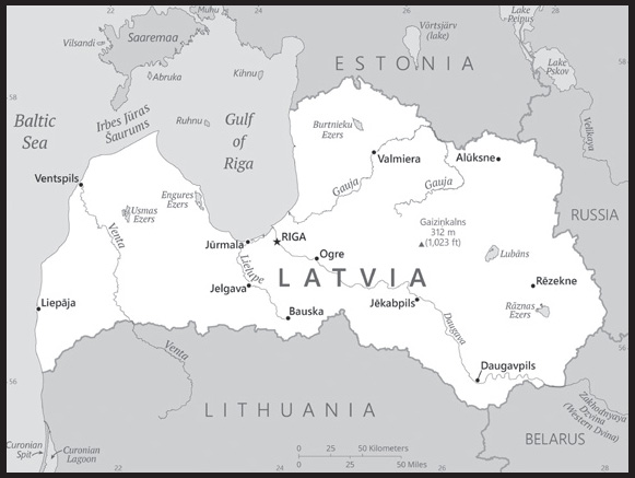
Location: Eastern Europe, bordering the Baltic Sea, between Estonia and Lithuania
Geographic coordinates: 57 00 N, 25 00 E
Map references: Europe
Area: total: 64,589 sq km
land: 62,249 sq km
water: 2,340 sq km
comparison ranking: total 124
Area - comparative: slightly larger than West Virginia
Land boundaries: total: 1,370 km
border countries (4): Belarus 161 km; Estonia 333 km; Lithuania 544 km; Russia 332 km
Coastline: 498 km
Maritime claims: territorial sea: 12 nm
exclusive economic zone: limits as agreed to by Estonia, Finland, Latvia, Sweden, and Russia
continental shelf: 200 m depth or to the depth of exploitation
Climate: maritime; wet, moderate winters
Terrain: low plain
Elevation: highest point: Gaizina Kalns 312 m
lowest point: Baltic Sea 0 m
mean elevation: 87 m
Natural resources: peat, limestone, dolomite, amber, hydropower, timber, arable land
Land use: agricultural land: 29.2% (2018 est.)
arable land: 18.6% (2018 est.)
permanent crops: 0.1% (2018 est.)
permanent pasture: 10.5% (2018 est.)
forest: 54.1% (2018 est.)
other: 16.7% (2018 est.)
Irrigated land: 6 sq km (2016)
note: land in Latvia is often too wet and in need of drainage not irrigation; approximately 16,000 sq km or 85% of agricultural land has been improved by drainage
Population distribution: largest concentration of people is found in and around the port and capital city of Riga; small agglomerations are scattered throughout the country
Natural hazards: large percentage of agricultural fields can become waterlogged and require drainage
Geography - note: most of the country is composed of fertile low-lying plains with some hills in the east
PEOPLE AND SOCIETY
Population: 1,821,750 (2023 est.)
comparison ranking: 153
Nationality: noun: Latvian(s)
adjective: Latvian
Ethnic groups: Latvian 62.7%, Russian 24.5%, Belarusian 3.1%, Ukrainian 2.2%, Polish 2%, Lithuanian 1.1%, other 1.8%, unspecified 2.6% (2021 est.)
Languages: Latvian (official) 56.3%, Russian 33.8%, other 0.6% (includes Polish, Ukrainian, and Belarusian), unspecified 9.4%; note - data represent language usually spoken at home (2011 est.)
major-language sample(s): World Factbook, neaizstājams avots pamata informāciju. (Latvian)
Religions: Lutheran 36.2%, Roman Catholic 19.5%, Orthodox 19.1%, other Christian 1.6%, other 0.1%, unspecified/none 23.5% (2017 est.)
Age structure: 0-14 years: 14.92% (male 139,877/female 131,839)
15-64 years: 63.37% (male 570,902/female 583,578)
65 years and over: 21.71% (2023 est.) (male 134,809/female 260,745)
Dependency ratios: total dependency ratio: 59.3
youth dependency ratio: 24.9
elderly dependency ratio: 34.4
potential support ratio: 2.9 (2021 est.)
Median age: total: 44.4 years (2020)
male: 40.5 years
female: 48 years
comparison ranking: total 16
Population growth rate: -1.13% (2023 est.)
comparison ranking: 231
Birth rate: 8.5 births/1,000 population (2023 est.)
comparison ranking: 210
Death rate: 14.69 deaths/1,000 population (2023 est.)
comparison ranking: 4
Net migration rate: -5.06 migrant(s)/1,000 population (2023 est.)
comparison ranking: 204
Population distribution: largest concentration of people is found in and around the port and capital city of Riga; small agglomerations are scattered throughout the country
Urbanization: urban population: 68.7% of total population (2023)
rate of urbanization: -0.68% annual rate of change (2020-25 est.)
Major urban areas - population: 621,000 RIGA (capital) (2023)
Sex ratio: at birth: 1.05 male(s)/female
0-14 years: 1.06 male(s)/female
15-64 years: 0.98 male(s)/female
65 years and over: 0.52 male(s)/female
total population: 0.87 male(s)/female (2023 est.)
Mother’s mean age at first birth: 27.3 years (2020 est.)
Maternal mortality ratio: 18 deaths/100,000 live births (2020 est.)
comparison ranking: 128
Infant mortality rate: total: 4.78 deaths/1,000 live births (2023 est.)
male: 5.2 deaths/1,000 live births
female: 4.34 deaths/1,000 live births
comparison ranking: total 177
Life expectancy at birth: total population: 76.16 years (2023 est.)
male: 71.75 years
female: 80.79 years
comparison ranking: total population 113
Total fertility rate: 1.55 children born/woman (2023 est.)
comparison ranking: 194
Gross reproduction rate: 0.76 (2023 est.)
Drinking water source: improved: urban: 99.9% of population
rural: 98.6% of population
total: 99.5% of population
unimproved: urban: 0.1% of population
rural: 1.4% of population
total: 0.5% of population (2020 est.)
Current health expenditure: 7.5% of GDP (2020)
Physicians density: 3.4 physicians/1,000 population (2020)
Hospital bed density: 5.5 beds/1,000 population (2018)
Sanitation facility access: improved: urban: 98.9% of population
rural: 85.3% of population
total: 94.6% of population
unimproved: urban: 1.1% of population
rural: 14.7% of population
total: 5.4% of population (2020 est.)
Major infectious diseases: degree of risk: intermediate (2023)
vectorborne diseases: tickborne encephalitis
Obesity - adult prevalence rate: 23.6% (2016)
comparison ranking: 65
Alcohol consumption per capita: total: 12.9 liters of pure alcohol (2019 est.)
beer: 4.9 liters of pure alcohol (2019 est.)
wine: 1.7 liters of pure alcohol (2019 est.)
spirits: 5.3 liters of pure alcohol (2019 est.)
other alcohols: 1 liters of pure alcohol (2019 est.)
comparison ranking: total 2
Tobacco use: total: 37% (2020 est.)
male: 50.3% (2020 est.)
female: 23.7% (2020 est.)
comparison ranking: total 10
Children under the age of 5 years underweight: 21.1% (2020/21)
comparison ranking: 14
Currently married women (ages 15-49): 49.1% (2023 est.)
Education expenditures: 6% of GDP (2020 est.)
comparison ranking: 44
Literacy: definition: age 15 and over can read and write
total population: 99.9%
male: 99.9%
female: 99.9% (2021)
School life expectancy (primary to tertiary education): total: 16 years
male: 16 years
female: 17 years (2020)
Youth unemployment rate (ages 15-24): total: 15.5% (2021 est.)
male: 12%
female: 19.6%
comparison ranking: total 113
ENVIRONMENT
Environment - current issues: while land, water, and air pollution are evident, Latvia’s environment has benefited from a shift to service industries after the country regained independence; improvements have occurred in drinking water quality, sewage treatment, household and hazardous waste management, as well as reduction of air pollution; concerns include nature protection and the management of water resources and the protection of the Baltic Sea
Environment - international agreements: party to: Air Pollution, Air Pollution-Heavy Metals, Air Pollution-Multi-effect Protocol, Air Pollution-Persistent Organic Pollutants, Biodiversity, Climate Change, Climate Change-Kyoto Protocol, Climate Change-Paris Agreement, Comprehensive Nuclear Test Ban, Desertification, Endangered Species, Hazardous Wastes, Law of the Sea, Ozone Layer Protection, Ship Pollution, Tropical Timber 2006, Wetlands
signed, but not ratified: none of the selected agreements
Climate: maritime; wet, moderate winters
Land use: agricultural land: 29.2% (2018 est.)
arable land: 18.6% (2018 est.)
permanent crops: 0.1% (2018 est.)
permanent pasture: 10.5% (2018 est.)
forest: 54.1% (2018 est.)
other: 16.7% (2018 est.)
Urbanization: urban population: 68.7% of total population (2023)
rate of urbanization: -0.68% annual rate of change (2020-25 est.)
Revenue from forest resources: 0.85% of GDP (2018 est.)
comparison ranking: 55
Revenue from coal: 0% of GDP (2018 est.)
comparison ranking: 134
Air pollutants: particulate matter emissions: 12.02 micrograms per cubic meter (2019 est.)
carbon dioxide emissions: 7 megatons (2016 est.)
methane emissions: 1.85 megatons (2020 est.)
Waste and recycling: municipal solid waste generated annually: 857,000 tons (2015 est.)
municipal solid waste recycled annually: 181,941 tons (2015 est.)
percent of municipal solid waste recycled: 21.2% (2015 est.)
Total water withdrawal: municipal: 90 million cubic meters (2020 est.)
industrial: 40 million cubic meters (2020 est.)
agricultural: 60 million cubic meters (2020 est.)
Total renewable water resources: 34.94 billion cubic meters (2020 est.)
GOVERNMENT
Country name: conventional long form: Republic of Latvia
conventional short form: Latvia
local long form: Latvijas Republika
local short form: Latvija
former: Latvian Soviet Socialist Republic (while occupied by the USSR)
etymology: the name “Latvia” originates from the ancient Latgalians, one of four eastern Baltic tribes that formed the ethnic core of the Latvian people (ca. 8th-12th centuries A.D.)
Government type: parliamentary republic
Capital: name: Riga
geographic coordinates: 56 57 N, 24 06 E
time difference: UTC+2 (7 hours ahead of Washington, DC, during Standard Time)
daylight saving time: +1hr, begins last Sunday in March; ends last Sunday in October
etymology: of the several theories explaining the name’s origin, the one relating to the city’s role in Baltic and North Sea commerce is the most probable; the name is likely related to the Latvian word “rija,” meaning “warehouse,” where the ‘j’ became a ‘g’ under the heavy German influence in the city from the late Middle Ages to the early 20th century
Administrative divisions: 36 municipalities (novadi, singular - novads) and 7 state cities (valstpilsetu pasvaldibas, singular valstspilsetas pasvaldiba)
municipalities: Adazi, Aizkraukle, Aluksne, Augsdaugava, Balvi, Bauska, Cesis, Dienvidkurzeme, Dobele, Gulbene, Jekabpils, Jelgava, Kekava, Kraslava, Kuldiga, Limbazi, Livani, Ludza, Madona, Marupe, Ogre, Olaine, Preili, Rezekne, Ropazi, Salaspils, Saldus, Saulkrasti, Sigulda, Smiltene, Talsi, Tukums, Valka, Valmiera, Varaklani, Ventspils
cities: Daugavpils, Jelgava, Jurmala, Liepaja, Rezekne, Riga, Ventspils
Independence: 18 November 1918 (from Soviet Russia); 4 May 1990 (declared from the Soviet Union); 6 September 1991 (recognized by the Soviet Union)
National holiday: Independence Day (Republic of Latvia Proclamation Day), 18 November (1918); note - 18 November 1918 was the date Latvia established its statehood and its concomitant independence from Soviet Russia; 4 May 1990 was the date it declared the restoration of Latvian statehood and its concomitant independence from the Soviet Union
Constitution: history: several previous (pre-1991 independence); note - following the restoration of independence in 1991, parts of the 1922 constitution were reintroduced 4 May 1990 and fully reintroduced 6 July 1993
amendments: proposed by two thirds of Parliament members or by petition of one tenth of qualified voters submitted through the president; passage requires at least two-thirds majority vote of Parliament in each of three readings; amendment of constitutional articles, including national sovereignty, language, the parliamentary electoral system, and constitutional amendment procedures, requires passage in a referendum by majority vote of at least one half of the electorate; amended several times, last in 2019
Legal system: civil law system with traces of socialist legal traditions and practices
International law organization participation: has not submitted an ICJ jurisdiction declaration; accepts ICCt jurisdiction
Citizenship: citizenship by birth: no
citizenship by descent only: at least one parent must be a citizen of Latvia
dual citizenship recognized: no
residency requirement for naturalization: 5 years
Suffrage: 18 years of age; universal
Executive branch: chief of state: President Edgars RINKEVICS (since 8 July 2023)
head of government: Prime Minister Evika SILINA (since 15 September 2023)
cabinet: Cabinet of Ministers nominated by the prime minister, appointed by Parliament
elections/appointments: president indirectly elected by Parliament for a 4-year term (eligible for a second term); election last held on 31 May 2023 (next to be held in 2027); prime minister appointed by the president, confirmed by Parliament
election results:
2023: Edgars RINKEVICS elected president; Parliament vote - Edgars RINKEVICS 52, Uldis Pīlēns 25 third round on 31 May 2023
2019: Egils LEVITS elected president; Parliament vote - Egils LEVITS 61, Didzis SMITS 24, Juris JANSONS 8; Krisjanis KARINS confirmed prime minister 61-39
note: on 15 September 2023, Parliament voted 53-39 to approve Prime Minister Evika SILINA
Legislative branch: description: unicameral Parliament or Saeima (100 seats; members directly elected in multi-seat constituencies by party-list proportional representation vote; members serve 4-year terms)
elections: last held on 1 October 2012 (next to be held no later than 3 October 2026)
election results: percent of vote by party - JV 19.2%, ZZS 12.6%, AS 11.1%, NA 9.4%, S! 6.9%, LPV 6.3%, and PRO 6.2%; seats by party - JV 26, ZZS 16, AS 15, NA 13, S! 11, LPV 9, and PRO 10
Judicial branch: highest court(s): Supreme Court (consists of the Senate with 36 judges); Constitutional Court (consists of 7 judges)
judge selection and term of office: Supreme Court judges nominated by chief justice and confirmed by the Saeima; judges serve until age 70, but term can be extended 2 years; Constitutional Court judges - 3 nominated by Saeima members, 2 by Cabinet ministers, and 2 by plenum of Supreme Court; all judges confirmed by Saeima majority vote; Constitutional Court president and vice president serve in their positions for 3 years; all judges serve 10-year terms; mandatory retirement at age 70
subordinate courts: district (city) and regional courts
Political parties and leaders: Development/For! or AP! [Daniels PAVLUTS, Ivars IJABS]
For Stability or S! [Aleksejs ROSLIKOVS]
Latvia First [Ainars SLESERS]
Latvian Green Party or LZP (Edgars TAVARS)
National Alliance “All For Latvia!”-”For Fatherland and Freedom/LNNK” or NA [Raivis DZINTARS]
New Unity or JV [Arturs Krišjānis KARINS]
Social Democratic Party “Harmony” or S [Janis URBANOVICS]
The Progressives or PRO [Kaspars BRISKENS]
Union of Greens and Farmers or ZZS [Aivars LEMBERGS]
United List or AS [Uldis PILENS] (electoral coalition including the Latvian Green Party or LZP, Latvian Association of Regions or LRA, Liepaja Party)
International organization participation: Australia Group, BA, BIS, CBSS, CD, CE, EAPC, EBRD, ECB, EIB, EMU, ESA (cooperating state), EU, FAO, IAEA, IBRD, ICAO, ICC (NGOs), ICCt, ICRM, IDA, IFC, IFRCS, IHO, ILO, IMF, IMO, IMSO, Interpol, IOC, IOM, IPU, ISO (correspondent), ITU, ITUC (NGOs), MIGA, NATO, NIB, NSG, OAS (observer), OIF (observer), OPCW, OSCE, PCA, Schengen Convention, UN, UNCTAD, UNESCO, UNHCR, UNWTO, UPU, Wassenaar Arrangement, WCO, WHO, WIPO, WMO, WTO
Diplomatic representation in the US: chief of mission: Ambassador Maris SELGA (since 16 September 2019)
chancery: 2306 Massachusetts Avenue NW, Washington, DC 20008
telephone: [1] (202) 328-2840
FAX: [1] (202) 328-2860
email address and website:
https://www2.mfa.gov.lv/en/usa
Diplomatic representation from the US: chief of mission: Ambassador Christopher ROBINSON (since 21 February 2023)
embassy: 1 Samnera Velsa Street (former Remtes), Riga LV-1510
mailing address: 4520 Riga Place, Washington DC 20521-4520
telephone: [371] 6710-7000
FAX: [371] 6710-7050
email address and website:
Flag description: three horizontal bands of maroon (top), white (half-width), and maroon; the flag is one of the older banners in the world; a medieval chronicle mentions a red standard with a white stripe being used by Latvian tribes in about 1280
National symbol(s): white wagtail (bird); national colors: maroon, white
National anthem: name: “Dievs, sveti Latviju!” (God Bless Latvia)
lyrics/music: Karlis BAUMANIS
note: adopted 1920, restored 1990; first performed in 1873 while Latvia was a part of Russia; banned during the Soviet occupation from 1940 to 1990
National heritage: total World Heritage Sites: 3 (both cultural)
selected World Heritage Site locales: Historic Center of Riga; Struve Geodetic Arc; Old town of Kuldiga
ECONOMY
Economic overview: high-income, EU-member Baltic economy; export-driven; Russian invasion of Ukraine has caused a temporary labor force surge and impacted growth due to Russian trade reliance; highly developed transit services
Real GDP (purchasing power parity): $60.457 billion (2021 est.)
$58.094 billion (2020 est.)
$59.403 billion (2019 est.)
note: data are in 2017 dollars
comparison ranking: 106
Real GDP growth rate: 4.07% (2021 est.)
-2.2% (2020 est.)
2.57% (2019 est.)
comparison ranking: 120
Real GDP per capita: $32,100 (2021 est.)
$30,600 (2020 est.)
$31,000 (2019 est.)
note: data are in 2017 dollars
comparison ranking: 66
GDP (official exchange rate): $34.084 billion (2019 est.)
Inflation rate (consumer prices): 3.28% (2021 est.)
0.22% (2020 est.)
2.81% (2019 est.)
comparison ranking: 115
Credit ratings: Fitch rating: A- (2014)
Moody’s rating: A3 (2015)
Standard & Poors rating: A+ (2020)
note: The year refers to the year in which the current credit rating was first obtained.
GDP - composition, by sector of origin: agriculture: 3.9% (2017 est.)
industry: 22.4% (2017 est.)
services: 73.7% (2017 est.)
comparison rankings: services 55; industry 128; agriculture 139
GDP - composition, by end use: household consumption: 61.8% (2017 est.)
government consumption: 18.2% (2017 est.)
investment in fixed capital: 19.9% (2017 est.)
investment in inventories: 1.5% (2017 est.)
exports of goods and services: 60.6% (2017 est.)
imports of goods and services: -61.9% (2017 est.)
Agricultural products: wheat, milk, rapeseed, barley, oats, potatoes, rye, beans, pork, poultry
Industries: processed foods, processed wood products, textiles, processed metals, pharmaceuticals, railroad cars, synthetic fibers, electronics
Industrial production growth rate: 1.93% (2021 est.)
comparison ranking: 136
Labor force: 955,000 (2021 est.)
comparison ranking: 146
Labor force - by occupation: agriculture: 7.7%
industry: 24.1%
services: 68.1% (2016 est.)
Unemployment rate: 7.6% (2021 est.)
8.1% (2020 est.)
6.31% (2019 est.)
comparison ranking: 102
Youth unemployment rate (ages 15-24): total: 15.5% (2021 est.)
male: 12%
female: 19.6%
comparison ranking: total 113
Population below poverty line: 22.9% (2018 est.)
Gini Index coefficient - distribution of family income: 34.5 (2019 est.)
comparison ranking: 109
Average household expenditures: on food: 17.3% of household expenditures (2018 est.)
on alcohol and tobacco: 7.9% of household expenditures (2018 est.)
Household income or consumption by percentage share: lowest 10%: 2.2%
highest 10%: 26.3% (2015)
Budget: revenues: $12.931 billion (2020 est.)
expenditures: $14.242 billion (2020 est.)
Budget surplus (+) or deficit (-): -0.5% (of GDP) (2017 est.)
comparison ranking: 61
Public debt: 36.3% of GDP (2017 est.)
37.4% of GDP (2016 est.)
note: data cover general government debt, and includes debt instruments issued (or owned) by government entities, including sub-sectors of central government, state government, local government, and social security funds
comparison ranking: 149
Taxes and other revenues: 21.77% (of GDP) (2020 est.)
comparison ranking: 75
Fiscal year: calendar year
Current account balance: -$1.7 billion (2021 est.)
$918.67 million (2020 est.)
-$200.203 million (2019 est.)
comparison ranking: 150
Exports: $25.248 billion (2021 est.) note: data are in current year dollars
$20.768 billion (2020 est.) note: data are in current year dollars
$20.539 billion (2019 est.) note: data are in current year dollars
comparison ranking: 79
Exports - partners: Lithuania 17%, Estonia 9%, United Kingdom 8%, Germany 7%, Russia 7% (2021)
Exports - commodities: lumber, wheat, broadcasting equipment, packaged medicines, fuel woods, hard liquors (2021)
Imports: $26.622 billion (2021 est.) note: data are in current year dollars
$20.427 billion (2020 est.) note: data are in current year dollars
$20.765 billion (2019 est.) note: data are in current year dollars
comparison ranking: 79
Imports - partners: Lithuania 15%, Russia 14%, Germany 9%, Poland 8%, Estonia 8% (2021)
Imports - commodities: refined petroleum, packaged medicines, broadcasting equipment, electricity, cars, natural gas (2021)
Reserves of foreign exchange and gold: $5.491 billion (31 December 2021 est.)
$5.29 billion (31 December 2020 est.)
$4.48 billion (31 December 2019 est.)
comparison ranking: 100
Debt - external: $40.164 billion (2019 est.)
$42.488 billion (2018 est.)
comparison ranking: 75
Exchange rates: euros (EUR) per US dollar -
Exchange rates:: 0.845 (2021 est.)
0.876 (2020 est.)
0.893 (2019 est.)
0.847 (2018 est.)
0.885 (2017 est.)
ENERGY
Electricity access: electrification - total population: 100% (2021)
Electricity: installed generating capacity: 3.089 million kW (2020 est.)
consumption: 6.706 billion kWh (2020 est.)
exports: 2.548 billion kWh (2020 est.)
imports: 4.173 billion kWh (2020 est.)
transmission/distribution losses: 377 million kWh (2020 est.)
comparison rankings: transmission/distribution losses 135; imports 45; exports 46; consumption 111; installed generating capacity 105
Electricity generation sources: fossil fuels: 33.4% of total installed capacity (2020 est.)
solar: 0.1% of total installed capacity (2020 est.)
wind: 3.2% of total installed capacity (2020 est.)
hydroelectricity: 47.5% of total installed capacity (2020 est.)
biomass and waste: 15.9% of total installed capacity (2020 est.)
Coal: production: 0 metric tons (2020 est.)
consumption: 39,000 metric tons (2020 est.)
exports: 3,000 metric tons (2020 est.)
imports: 40,000 metric tons (2020 est.)
proven reserves: 0 metric tons (2019 est.)
Petroleum: total petroleum production: 1,600 bbl/day (2021 est.)
refined petroleum consumption: 39,900 bbl/day (2019 est.)
Refined petroleum products - exports: 16,180 bbl/day (2017 est.)
comparison ranking: 72
Refined petroleum products - imports: 54,370 bbl/day (2017 est.)
comparison ranking: 77
Natural gas: production: 0 cubic meters (2021 est.)
consumption: 1.068 billion cubic meters (2020 est.)
exports: 0 cubic meters (2021 est.)
imports: 1.068 billion cubic meters (2020 est.)
proven reserves: 0 cubic meters (2021 est.)
Carbon dioxide emissions: 8.45 million metric tonnes of CO2 (2019 est.)
from coal and metallurgical coke: 149,000 metric tonnes of CO2 (2019 est.)
from petroleum and other liquids: 5.693 million metric tonnes of CO2 (2019 est.)
from consumed natural gas: 2.608 million metric tonnes of CO2 (2019 est.)
comparison ranking: total emissions 110
Energy consumption per capita: 86.645 million Btu/person (2019 est.)
comparison ranking: 66
COMMUNICATIONS
Telephones - fixed lines: total subscriptions: 191,798 (2021 est.)
subscriptions per 100 inhabitants: 10 (2021 est.)
comparison ranking: total subscriptions 123
Telephones - mobile cellular: total subscriptions: 2,161,725 (2021 est.)
subscriptions per 100 inhabitants: 115 (2021 est.)
comparison ranking: total subscriptions 148
Telecommunication systems: general assessment: the telecom market continues to benefit from investment and from regulatory measures aimed at developing 5G and fiber-based infrastructure; there is effective competition in the mobile market; these multi-service operators have focused investment on fiber networks and on expanding the reach of 5G (2023)
domestic: fixed-line roughly 10 per 100 and mobile-cellular nearly 115 per 100 subscriptions (2021)
international: country code - 371; the Latvian network is now connected via fiber-optic cable to Estonia, Finland, and Sweden
Broadcast media: several national and regional commercial TV stations are foreign-owned, 2 national TV stations are publicly owned; system supplemented by privately owned regional and local TV stations; cable and satellite multi-channel TV services with domestic and foreign broadcasts available; publicly owned broadcaster operates 4 radio networks with dozens of stations throughout the country; dozens of private broadcasters also operate radio stations
Internet country code: .lv
Internet users: total: 1.729 million (2021 est.)
percent of population: 91% (2021 est.)
comparison ranking: total 141
Broadband - fixed subscriptions: total: 490,569 (2020 est.)
subscriptions per 100 inhabitants: 26 (2020 est.)
comparison ranking: total 92
TRANSPORTATION
National air transport system: number of registered air carriers: 3 (2020)
inventory of registered aircraft operated by air carriers: 53
annual passenger traffic on registered air carriers: 4,058,762 (2018)
annual freight traffic on registered air carriers: 4.01 million (2018) mt-km
Civil aircraft registration country code prefix: YL
Airports: 42 (2021)
comparison ranking: total 100
Airports - with paved runways: 18
note: paved runways have a concrete or asphalt surface but not all have facilities for refueling, maintenance, or air traffic control; the length of a runway required for aircraft to safely operate depends on a number of factors including the type of aircraft, the takeoff weight (including passengers, cargo, and fuel), engine types, flap settings, landing speed, elevation of the airport, and average maximum daily air temperature; paved runways can reach a length of 5,000 m (16,000 ft.), but the “typical” length of a commercial airline runway is between 2,500-4,000 m (8,000-13,000 ft.)
Airports - with unpaved runways: 24
note: unpaved runways have a surface composition such as grass or packed earth and are most suited to the operation of light aircraft; unpaved runways are usually short, often less than 1,000 m (3,280 ft.) in length; airports with unpaved runways often lack facilities for refueling, maintenance, or air traffic control
Heliports: 1 (2021)
Pipelines: 1,213 km gas, 417 km refined products (2018)
Railways: total: 2,216 km (2020) 257 km electrified
comparison ranking: total 69
Roadways: total: 70,244 km (2018)
paved: 15,158 km (2018)
unpaved: 55,086 km (2018)
comparison ranking: total 68
Waterways: 300 km (2010) (navigable year-round)
comparison ranking: 101
Merchant marine: total: 80 (2022)
by type: container ship 2, general cargo 30, oil tanker 9, other 39
comparison ranking: total 100
Ports and terminals: major seaport(s): Riga, Ventspils
Transportation - note: Latvia operates one PC 5 or 6 class icebreaker in the Baltic Sea
note – PC indicates a Polar Class vessel: PC 5 - year-round operation in medium first-year ice which may include old ice inclusions (ice thickness up to 70-120 cm); PC 6 - summer/autumn operation in medium first-year ice which may include old ice inclusions (ice thickness up to 30-70 cm)
MILITARY AND SECURITY
Military and security forces: National Armed Forces (Nacionalie Brunotie Speki or NBS): Land Forces (Latvijas Sauszemes Speki), Naval Force (Latvijas Juras Speki, includes Coast Guard (Latvijas Kara Flote)), Air Force (Latvijas Gaisa Speki), National Guard (aka Land Guard or Zemessardze) (2023)
note: the armed forces, the Defense Intelligence and Security Service, the Constitution Protection Bureau, and the National Guard are subordinate to the Ministry of Defense; the State Police, State Border Guards, and State Security Service are under the Ministry of Interior; the State Border Guard may become part of the armed forces during an emergency
Military expenditures: 2.3% of GDP (2023 est.)
2.1% of GDP (2022 est.)
2.1% of GDP (2021)
2.2% of GDP (2020)
2% of GDP (2019)
comparison ranking: 49
Military and security service personnel strengths: approximately 7,000 regular military forces; approximately 9,500 National Guard (2023)
Military equipment inventories and acquisitions: the Latvian military’s inventory consists of a mixture of Soviet-era and limited amounts of more modern, Western-produced systems acquired since the country joined NATO in 2004; in recent years, the UK and US have been the leading suppliers of military equipment (2023)
Military service age and obligation: 18 years of age for voluntary military service for men and women; no conscription (abolished 2007) (2023)
note 1: in 2023, the Latvian Parliament approved a plan to reinstate mandatory military service for men aged 18-27 (women voluntarily) beginning in 2024; service would be for 12 months in the Land Forces or alternatively in internal affairs, health, or welfare structures
note 2: as of 2022, women comprised about 16% of the military’s full-time personnel
Military deployments: 130 Kosovo (KFOR/NATO) (2023)
Military - note: the National Armed Forces are responsible for the defense of the country’s sovereignty and territory; they also have some domestic security responsibilities, including coast guard functions, search and rescue, humanitarian assistance, and providing support to other internal security services, including the State Border Service, the State Police, and the State Security Service; the Military Police provides protection to the president and other government officials, foreign dignitaries, and key facilities; for external defense, Latvia’s primary security focus is Russia, which has only increased since the Russian seizure of Crimea in 2014 and full-scale attack on Ukraine in 2022; in 2004, it joined NATO and the EU, which it depends on to play a decisive role in Latvia’s security policy; Latvia is actively engaged in both NATO and the EU, as well as bilaterally with its allies in order to bolster its own security and that of the surrounding region; the Latvian military has participated in NATO and EU missions abroad and regularly conducts training and exercises with NATO and EU partner forces; Latvia also hosts NATO partner forces and is a member of the UK-led Joint Expeditionary Force, a pool of high-readiness military forces from 10 Baltic and Scandinavian countries designed to respond to a wide range of contingencies in the North Atlantic, Baltic Sea, and High North regions
the Land Forces have a single mechanized brigade; since 2017, Latvia has hosted a Canadian-led multinational NATO ground force battlegroup as part of the Alliance’s Enhanced Forward Presence initiative; in addition, Latvia hosts a NATO-led divisional headquarters (Multinational Division North; activated 2020), which coordinates training and preparation activities of its respective subordinate NATO battlegroups in Estonia and Latvia; the Land Forces are supplemented by the National Guard, which has four regionally based infantry brigades that are manned mostly by part-time personnel supplemented by some full-time professional soldiers; in peacetime, the brigades participate in emergency, fire and rescue operations, and in the “elimination of consequences caused by emergency situations”
the Air Force has no combat aircraft; NATO has provided air protection for Latvia since 2004 through its Baltics Air Policing mission; NATO member countries that possess air combat capabilities voluntarily contribute to the mission on four-month rotations; the Naval Forces feature a few patrol vessels and minesweepers; the military also has logistics, military police, special operations forces, and training commands (2023)
TRANSNATIONAL ISSUES
Disputes - international: Latvia-Belarus: Belarus and Latvia signed joint demarcation map in September 2008
Latvia-Estonia: demarcation reportedly completed in 1998
Latvia-Lithuania: boundary demarcation was completed by the end of 1998; the Latvian parliament has not ratified its 1998 maritime boundary treaty with Lithuania, primarily due to concerns over oil exploration rights
Latvia-Russia: Russia demands better Latvian treatment of ethnic Russians in Latvia; in March 2007, Latvia and Russia signed a border treaty, which includes Latvia withdrawing claims to a district now in Russia that was part of Latvia before WWII; the permanent demarcation of the boundary between Latvia and Russia was completed and came into force in April 2018; as a member state that forms part of the EU’s external border, Latvia has implemented the strict Schengen border rules with Russia
Refugees and internally displaced persons: refugees (country of origin): 32,470 (Ukraine) (as of 15 August 2023)
stateless persons: 195,354 (2022); note - individuals who were Latvian citizens prior to the 1940 Soviet occupation and their descendants were recognized as Latvian citizens when the country’s independence was restored in 1991; citizens of the former Soviet Union residing in Latvia who have neither Latvian nor other citizenship are considered non-citizens (officially there is no statelessness in Latvia) and are entitled to non-citizen passports; children born after Latvian independence to stateless parents are entitled to Latvian citizenship upon their parents’ request; non-citizens cannot vote or hold certain government jobs and are exempt from military service but can travel visa-free in the EU under the Schengen accord like Latvian citizens; non-citizens can obtain naturalization if they have been permanent residents of Latvia for at least five years, pass tests in Latvian language and history, and know the words of the Latvian national anthem
Illicit drugs: transshipment and destination point for cocaine, synthetic drugs, opiates, and cannabis from Southwest Asia, Western Europe, Latin America, and neighboring Baltic countries; despite improved legislation, vulnerable to money laundering due to nascent enforcement capabilities and comparatively weak regulation of offshore companies and the gaming industry; CIS organized crime (including counterfeiting, corruption, extortion, stolen cars, and prostitution) accounts for most laundered proceeds
INTRODUCTION
Background: As a result of its location at the crossroads of three continents, the area that is modern-day Lebanon is rich in cultural and religious diversity. This region was subject to various foreign conquests for much of its history, including by the Romans, Arabs, and Ottomans. Following World War I, France acquired a mandate over the northern portion of the former Ottoman Empire province of Syria. From it the French demarcated the region of Lebanon in 1920, and it gained independence in 1943. Since then, Lebanon has experienced periods of political turmoil interspersed with prosperity built on its historical position as a regional center for finance and trade, although that status has significantly diminished since the beginning of Lebanon’s economic crisis in 2019, which includes simultaneous currency, debt, and banking crises. The country’s 1975-90 civil war, which resulted in an estimated 120,000 fatalities, was followed by years of social and political instability. Sectarianism is a key element of Lebanese political life. Neighboring Syria has historically influenced Lebanon’s foreign and domestic policies, and its military occupied Lebanon from 1976 until 2005. Hizballah - a major Lebanese political party, militia, and US-designated foreign terrorist organization - and Israel continued attacks and counterattacks against each other after Syria’s withdrawal and fought a brief war in 2006. Lebanon’s borders with Syria and Israel remain unresolved.
Since 2019, Lebanon has experienced a severe economic crisis that has crippled its economy, shut down its previously lucrative banking sector, reduced the value of its currency, and caused many Lebanese to emigrate in search of better prospects.
GEOGRAPHY
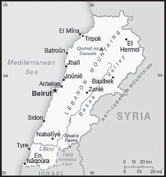
Location: Middle East, bordering the Mediterranean Sea, between Israel and Syria
Geographic coordinates: 33 50 N, 35 50 E
Map references: Middle East
Area: total: 10,400 sq km
land: 10,230 sq km
water: 170 sq km
comparison ranking: total 168
Area - comparative: about one-third the size of Maryland
Land boundaries: total: 484 km
border countries (2): Israel 81 km; Syria 403 km
Coastline: 225 km
Maritime claims: territorial sea: 12 nm
Climate: Mediterranean; mild to cool, wet winters with hot, dry summers; the Lebanon Mountains experience heavy winter snows
Terrain: narrow coastal plain; El Beqaa (Bekaa Valley) separates Lebanon and Anti-Lebanon Mountains
Elevation: highest point: Qornet es Saouda 3,088 m
lowest point: Mediterranean Sea 0 m
mean elevation: 1,250 m
Natural resources: limestone, iron ore, salt, water-surplus state in a water-deficit region, arable land
Land use: agricultural land: 63.3% (2018 est.)
arable land: 11.9% (2018 est.)
permanent crops: 12.3% (2018 est.)
permanent pasture: 39.1% (2018 est.)
forest: 13.4% (2018 est.)
other: 23.3% (2018 est.)
Irrigated land: 1,040 sq km (2012)
Population distribution: the majority of the people live on or near the Mediterranean coast, and of these most live in and around the capital, Beirut; favorable growing conditions in the Bekaa Valley, on the southeastern side of the Lebanon Mountains, have attracted farmers and thus the area exhibits a smaller population density
Natural hazards: earthquakes; dust storms, sandstorms
Geography - note: smallest country in continental Asia; Nahr el Litani is the only major river in Near East not crossing an international boundary; rugged terrain historically helped isolate, protect, and develop numerous factional groups based on religion, clan, and ethnicity
PEOPLE AND SOCIETY
Population: 5,331,203 (2023 est.)
comparison ranking: 122
Nationality: noun: Lebanese (singular and plural)
adjective: Lebanese
Ethnic groups: Arab 95%, Armenian 4%, other 1%
note: many Christian Lebanese do not identify themselves as Arab but rather as descendants of the ancient Canaanites and prefer to be called Phoenicians
Languages: Arabic (official), French, English, Armenian
major-language sample(s):

(Arabic)
The World Factbook, une source indispensable d’informations de base. (French)
Religions: Muslim 67.8% (31.9% Sunni, 31.2% Shia, smaller percentages of Alawites and Ismailis), Christian 32.4% (Maronite Catholics are the largest Christian group), Druze 4.5%, very small numbers of Jews, Baha’is, Buddhists, and Hindus (2020 est.)
note: data represent the religious affiliation of the citizen population (data do not include Lebanon’s sizable Syrian and Palestinian refugee populations); 18 religious sects recognized
Age structure: 0-14 years: 19.21% (male 524,172/female 500,185)
15-64 years: 71.69% (male 1,929,150/female 1,892,806)
65 years and over: 9.1% (2023 est.) (male 208,436/female 276,454)
Dependency ratios: total dependency ratio: 59.3
youth dependency ratio: 44
elderly dependency ratio: 15.3
potential support ratio: 6.5 (2021 est.)
Median age: total: 33.7 years (2020)
male: 33.1 years
female: 34.4 years
comparison ranking: total 95
Population growth rate: 0.64% (2023 est.)
comparison ranking: 133
Birth rate: 12.86 births/1,000 population (2023 est.)
comparison ranking: 138
Death rate: 5.57 deaths/1,000 population (2023 est.)
comparison ranking: 179
Net migration rate: -0.94 migrant(s)/1,000 population (2023 est.)
comparison ranking: 142
Population distribution: the majority of the people live on or near the Mediterranean coast, and of these most live in and around the capital, Beirut; favorable growing conditions in the Bekaa Valley, on the southeastern side of the Lebanon Mountains, have attracted farmers and thus the area exhibits a smaller population density
Urbanization: urban population: 89.4% of total population (2023)
rate of urbanization: -1.23% annual rate of change (2020-25 est.)
Major urban areas - population: 2.421 million BEIRUT (capital) (2023)
Sex ratio: at birth: 1.05 male(s)/female
0-14 years: 1.05 male(s)/female
15-64 years: 1.02 male(s)/female
65 years and over: 0.75 male(s)/female
total population: 1 male(s)/female (2023 est.)
Maternal mortality ratio: 21 deaths/100,000 live births (2020 est.)
comparison ranking: 123
Infant mortality rate: total: 6.88 deaths/1,000 live births (2023 est.)
male: 7.42 deaths/1,000 live births
female: 6.31 deaths/1,000 live births
comparison ranking: total 159
Life expectancy at birth: total population: 79 years (2023 est.)
male: 77.6 years
female: 80.46 years
comparison ranking: total population 68
Total fertility rate: 1.71 children born/woman (2023 est.)
comparison ranking: 164
Gross reproduction rate: 0.83 (2023 est.)
Contraceptive prevalence rate: NA
Drinking water source: improved: total: 100% of population
unimproved:
total: 0% of population (2020 est.)
Current health expenditure: 8% of GDP (2020)
Physicians density: 2.21 physicians/1,000 population (2019)
Hospital bed density: 2.7 beds/1,000 population (2017)
Sanitation facility access: improved: total: 100% of population
unimproved: total: 0% of population (2020 est.)
Obesity - adult prevalence rate: 32% (2016)
comparison ranking: 18
Alcohol consumption per capita: total: 1.14 liters of pure alcohol (2019 est.)
beer: 0.38 liters of pure alcohol (2019 est.)
wine: 0.21 liters of pure alcohol (2019 est.)
spirits: 0.53 liters of pure alcohol (2019 est.)
other alcohols: 0.02 liters of pure alcohol (2019 est.)
comparison ranking: total 150
Tobacco use: total: 38.2% (2020 est.)
male: 47.5% (2020 est.)
female: 28.9% (2020 est.)
comparison ranking: total 8
Children under the age of 5 years underweight: 3.4% (2021) NA
comparison ranking: 85
Currently married women (ages 15-49): 51.4% (2023 est.)
Child marriage: women married by age 15: 1.4%
women married by age 18: 6% (2016 est.)
Education expenditures: 1.7% of GDP (2020 est.)
comparison ranking: 190
Literacy: definition: age 15 and over can read and write
total population: 95.1%
male: 96.9%
female: 93.3% (2018)
School life expectancy (primary to tertiary education): total: 11 years
male: 12 years
female: 11 years (2014)
Youth unemployment rate (ages 15-24): total: 29.6% (2021 est.)
male: 30.8%
female: 26.7%
comparison ranking: total 42
ENVIRONMENT
Environment - current issues: deforestation; soil deterioration, erosion; desertification; species loss; air pollution in Beirut from vehicular traffic and the burning of industrial wastes; pollution of coastal waters from raw sewage and oil spills; waste-water management
Environment - international agreements: party to: Biodiversity, Climate Change, Climate Change-Kyoto Protocol, Climate Change-Paris Agreement, Comprehensive Nuclear Test Ban, Desertification, Endangered Species, Hazardous Wastes, Law of the Sea, Nuclear Test Ban, Ozone Layer Protection, Ship Pollution, Wetlands
signed, but not ratified: Environmental Modification, Marine Life Conservation
Climate: Mediterranean; mild to cool, wet winters with hot, dry summers; the Lebanon Mountains experience heavy winter snows
Land use: agricultural land: 63.3% (2018 est.)
arable land: 11.9% (2018 est.)
permanent crops: 12.3% (2018 est.)
permanent pasture: 39.1% (2018 est.)
forest: 13.4% (2018 est.)
other: 23.3% (2018 est.)
Urbanization: urban population: 89.4% of total population (2023)
rate of urbanization: -1.23% annual rate of change (2020-25 est.)
Food insecurity: widespread lack of access: due to the ongoing financial and economic crisis - in September 2021, the United Nations estimated that, taking into account multiple factors other than income, such as access to health, education and public utilities, 82% of the population lives in multidimensional poverty in 2021, up from 42% in 2019 (2022)
Revenue from forest resources: 0% of GDP (2018 est.)
comparison ranking: 185
Revenue from coal: 0% of GDP (2018 est.)
comparison ranking: 130
Air pollutants: particulate matter emissions: 24.23 micrograms per cubic meter (2019 est.)
carbon dioxide emissions: 24.8 megatons (2016 est.)
methane emissions: 3.37 megatons (2020 est.)
Waste and recycling: municipal solid waste generated annually: 2.04 million tons (2014 est.)
municipal solid waste recycled annually: 163,200 tons (2014 est.)
percent of municipal solid waste recycled: 8% (2014 est.)
Total water withdrawal: municipal: 240 million cubic meters (2020 est.)
industrial: 900 million cubic meters (2020 est.)
agricultural: 700 million cubic meters (2020 est.)
Total renewable water resources: 4.5 billion cubic meters (2020 est.)
GOVERNMENT
Country name: conventional long form: Lebanese Republic
conventional short form: Lebanon
local long form: Al Jumhuriyah al Lubnaniyah
local short form: Lubnan
former: Greater Lebanon
etymology: derives from the Semitic root “lbn” meaning “white” and refers to snow-capped Mount Lebanon
Government type: parliamentary republic
Capital: name: Beirut
geographic coordinates: 33 52 N, 35 30 E
time difference: UTC+2 (7 hours ahead of Washington, DC, during Standard Time)
daylight saving time: +1hr, begins last Sunday in March; ends last Sunday in October
etymology: derived from the Canaanite or Phoenician word “ber’ot,” meaning “the wells” or “fountain,” which referred to the site’s accessible water table
Administrative divisions: 8 governorates (mohafazat, singular - mohafazah); Aakkar, Baalbek-Hermel, Beqaa (Bekaa), Beyrouth (Beirut), Liban-Nord (North Lebanon), Liban-Sud (South Lebanon), Mont-Liban (Mount Lebanon), Nabatiye
Independence: 22 November 1943 (from League of Nations mandate under French administration)
National holiday: Independence Day, 22 November (1943)
Constitution: history: drafted 15 May 1926, adopted 23 May 1926
amendments: proposed by the president of the republic and introduced as a government bill to the National Assembly or proposed by at least 10 members of the Assembly and agreed upon by two thirds of its members; if proposed by the National Assembly, review and approval by two-thirds majority of the Cabinet is required; if approved, the proposal is next submitted to the Cabinet for drafting as an amendment; Cabinet approval requires at least two-thirds majority, followed by submission to the National Assembly for discussion and vote; passage requires at least two-thirds majority vote of a required two-thirds quorum of the Assembly membership and promulgation by the president; amended several times, last in 2004
Legal system: mixed legal system of civil law based on the French civil code, Ottoman legal tradition, and religious laws covering personal status, marriage, divorce, and other family relations of the Jewish, Islamic, and Christian communities
International law organization participation: has not submitted an ICJ jurisdiction declaration; non-party state to the ICCt
Citizenship: citizenship by birth: no
citizenship by descent only: the father must be a citizen of Lebanon
dual citizenship recognized: yes
residency requirement for naturalization: unknown
Suffrage: 21 years of age; authorized for all men and women regardless of religion; excludes persons convicted of felonies and other crimes or those imprisoned; excludes all military and security service personnel regardless of rank
Executive branch: chief of state: president (vacant)
head of government: Caretaker Prime Minister Najib MIQATI (since 20 September 2021)
cabinet: Cabinet chosen by the prime minister in consultation with the president and Parliament
elections/appointments: president indirectly elected by Parliament with two-thirds majority vote in the first round and if needed absolute majority vote in a second round for a 6-year term (eligible for non-consecutive terms); last held on 31 October 2016 (presidential election ongoing as of mid-May 2023); prime minister appointed by the president in consultation with Parliament; deputy prime minister determined during cabinet formation
election results:
2023: on 14 June 2023, Parliament failed in its twelfth attempt to elect a president; Parliament vote (first round) - Sulayman FRANJIEH (Marada Movement) 59, Jihad AZOUR (independent) 51; note - the Hezbollah bloc withdrew following the first-round voting and a second round was not possible since Parliament lacked the required 86-member quorum for a second-round vote
2016: Michel AWN elected president in second round; Parliament vote - Michel AWN (FPM) 83; note - in the initial election held on 23 April 2014, no candidate received the required two-thirds vote, and subsequent attempts failed because Parliament lacked the necessary quorum of 86 members to hold a vote; the president was finally elected in its 46th attempt on 31 October 2016
Legislative branch: description: unicameral Lebanese Parliament or Majlis al-Nuwab in Arabic, Chambre des députés in French (128 seats; members directly elected in multi-member constituencies by open list proportional representation vote, apportioned evenly between Christian and Muslims; members serve 4-year terms)
elections: last held on 15 May 2022 (next to be held in May 2026)
election results: percent of vote by coalition/party – NA; seats by party/coalition – FPM 16, LF 14, Amal Movement 13, Hezbollah 13, PSP 9, FM (candidates did not run in 2022; members ran as independents) 8, Kata’ib Party 4, other 30, independent 21; composition - men 120, women 8, percent of women 6.3%; note -a dozen of the elected deputies are from groups pushing for reform with origins in the recent protest movements against the established elite and have formed a group called the “Forces of Change”
note: Lebanon’s constitution states the Lebanese Parliament cannot conduct regular business until it elects a president when the position is vacant
Judicial branch: highest court(s): Court of Cassation or Supreme Court (organized into 8 chambers, each with a presiding judge and 2 associate judges); Constitutional Council (consists of 10 members)
judge selection and term of office: Court of Cassation judges appointed by Supreme Judicial Council, a 10-member body headed by the chief justice, and includes other judicial officials; judge tenure NA; Constitutional Council members appointed - 5 by the Council of Ministers and 5 by parliament; members serve 5-year terms
subordinate courts: Courts of Appeal; Courts of First Instance; specialized tribunals, religious courts; military courts
Political parties and leaders: Al-Ahbash (Association of Islamic Charitable Projects) or AICP [Shaykh Hussam QARAQIRA]
Amal Movement (“Hope Movement”) [Nabih BERRI]
Azm Movement [Najib MIQATI]
Ba’th Arab Socialist Party of Lebanon [leader disputed]
Free Patriotic Movement or FPM [Gibran BASSIL]
Future Movement Bloc or FM [Sa’ad al-HARIRI] (resigned from politics in January 2022)
Hizballah [Hassan NASRALLAH]
Islamic Action Front or IAF [Sheikh Zuhayr al-JU’AYD]
Kata’ib Party [Sami GEMAYEL]
Lebanese Democratic Party [Talal ARSLAN]
Lebanese Forces or LF [Samir JA’JA]
Marada Movement [Sulayman FRANJIEH]
Progressive Socialist Party or PSP [Taymour JUMBLATT] (JUMBLATT is also a member of Parliament)
Social Democrat Hunshaqian Party [Sabuh KALPAKIAN]
Syrian Social Nationalist Party or SSNP [Rabi BANAT]
Tashnaq or Armenian Revolutionary Federation [Hagop PAKRADOUNIAN]
International organization participation: ABEDA, AFESD, AMF, CAEU, FAO, G-24, G-77, IAEA, IBRD, ICAO, ICC (national committees), ICRM, IDA, IDB, IFAD, IFC, IFRCS, ILO, IMF, IMO, IMSO, Interpol, IOC, IPU, ISO, ITSO, ITU, LAS, MIGA, NAM, OAS (observer), OIC, OIF, OPCW, PCA, UN, UNCTAD, UNESCO, UNHCR, UNIDO, UNRWA, UNWTO, UPU, WCO, WFTU (NGOs), WHO, WIPO, WMO, WTO (observer)
Diplomatic representation in the US: chief of mission: Ambassador (vacant); Chargé d’Affaires Wael HACHEM, Counselor (since 15 March 2021)
chancery: 2560 28th Street NW, Washington, DC 20008
telephone: [1] (202) 939-6300
FAX: [1] (202) 939-6324
email address and website:
http://www.lebanonembassyus.org/
consulate(s) general: Detroit, New York, Los Angeles
Diplomatic representation from the US: chief of mission: Ambassador Dorothy C. SHEA (since 11 March 2020)
embassy: Awkar-Facing the Municipality, Main Street, Beirut
mailing address: 6070 Beirut Place, Washington DC 20521-6070
telephone: [961] (04) 543-600
FAX: [961] (4) 544-019
email address and website:
Flag description: three horizontal bands consisting of red (top), white (middle, double width), and red (bottom) with a green cedar tree centered in the white band; the red bands symbolize blood shed for liberation, the white band denotes peace, the snow of the mountains, and purity; the green cedar tree is the symbol of Lebanon and represents eternity, steadiness, happiness, and prosperity
National symbol(s): cedar tree; national colors: red, white, green
National anthem: name: “Kulluna lil-watan” (All Of Us, For Our Country!)
lyrics/music: Rachid NAKHLE/Wadih SABRA
note: adopted 1927; chosen following a nationwide competition
National heritage: total World Heritage Sites: 5 (all cultural)
selected World Heritage Site locales: Anjar; Baalbek; Byblos; Tyre; Ouadi Qadisha (the Holy Valley) and the Forest of the Cedars of God (Horsh Arz el-Rab)
ECONOMY
Economic overview: upper middle-income Middle Eastern economy; economic activity hurt by economic depression, COVID-19, and port explosion; hyperinflation and sharp poverty increases; banks have ceased lending; new financing facility helping with recovery
Real GDP (purchasing power parity): $72.577 billion (2021 est.)
$78.041 billion (2020 est.)
$99.288 billion (2019 est.)
note: data are in 2017 dollars
comparison ranking: 101
Real GDP growth rate: -7% (2021 est.)
-21.4% (2020 est.)
-7.16% (2019 est.)
comparison ranking: 216
Real GDP per capita: $13,000 (2021 est.)
$13,800 (2020 est.)
$17,200 (2019 est.)
note: data are in 2017 dollars
comparison ranking: 126
GDP (official exchange rate): $53.253 billion (2019 est.)
Inflation rate (consumer prices): 154.76% (2021 est.)
84.86% (2020 est.)
3.01% (2019 est.)
comparison ranking: 3
Credit ratings: Fitch rating: RD (2020)
Moody’s rating: C (2020)
Standard & Poors rating: D (2020)
note: The year refers to the year in which the current credit rating was first obtained.
GDP - composition, by sector of origin: agriculture: 3.9% (2017 est.)
industry: 13.1% (2017 est.)
services: 83% (2017 est.)
comparison rankings: services 24; industry 192; agriculture 140
GDP - composition, by end use: household consumption: 87.6% (2017 est.)
government consumption: 13.3% (2017 est.)
investment in fixed capital: 21.8% (2017 est.)
investment in inventories: 0.5% (2017 est.)
exports of goods and services: 23.6% (2017 est.)
imports of goods and services: -46.4% (2017 est.)
Agricultural products: potatoes, milk, tomatoes, apples, oranges, olives, wheat, cucumbers, poultry, lemons
Industries: banking, tourism, real estate and construction, food processing, wine, jewelry, cement, textiles, mineral and chemical products, wood and furniture products, oil refining, metal fabricating
Industrial production growth rate: -6.85% (2021 est.)
comparison ranking: 193
Labor force: 1.719 million (2021 est.)
note: excludes as many as 1 million foreign workers and refugees
comparison ranking: 130
Labor force - by occupation: agriculture: 39% (2009 est.) NA
industry: NA
services: NA
Unemployment rate: 14.49% (2021 est.)
13.3% (2020 est.)
11.35% (2019 est.)
comparison ranking: 38
Youth unemployment rate (ages 15-24): total: 29.6% (2021 est.)
male: 30.8%
female: 26.7%
comparison ranking: total 42
Population below poverty line: 27.4% (2011 est.)
Gini Index coefficient - distribution of family income: 31.8 (2011 est.)
comparison ranking: 136
Average household expenditures: on food: 20.7% of household expenditures (2018 est.)
on alcohol and tobacco: 1.2% of household expenditures (2018 est.)
Household income or consumption by percentage share: lowest 10%: NA
highest 10%: NA
Budget: revenues: $11.061 billion (2019 est.)
expenditures: $16.574 billion (2019 est.)
Budget surplus (+) or deficit (-): -6.9% (of GDP) (2017 est.)
comparison ranking: 193
Public debt: 146.8% of GDP (2017 est.)
145.5% of GDP (2016 est.)
note: data cover central government debt and exclude debt instruments issued (or owned) by government entities other than the treasury; the data include treasury debt held by foreign entities; the data include debt issued by subnational entities, as well as intragovernmental debt; intragovernmental debt consists of treasury borrowings from surpluses in the social funds, such as for retirement, medical care, and unemployment
comparison ranking: 6
Taxes and other revenues: 8.9% (of GDP) (2020 est.)
comparison ranking: 201
Fiscal year: calendar year
Current account balance: -$2.985 billion (2021 est.)
-$2.995 billion (2020 est.)
-$11.265 billion (2019 est.)
comparison ranking: 172
Exports: $10.147 billion (2021 est.) note: data are in current year dollars
$8.773 billion (2020 est.) note: data are in current year dollars
$18.208 billion (2019 est.)
comparison ranking: 104
Exports - partners: Switzerland 27%, United Arab Emirates 15%, South Korea 11%, Saudi Arabia 7%, Kuwait 6% (2019)
Exports - commodities: gold, diamonds, scrap iron, wood furniture, grapes, jewelry, cars (2021)
Imports: $17.383 billion (2021 est.) note: data are in current year dollars
$15.206 billion (2020 est.) note: data are in current year dollars
$31.147 billion (2019 est.)
comparison ranking: 95
Imports - partners: United Arab Emirates 11%, China 10%, Italy 8%, Greece 8%, Turkey 7%, United States 6% (2019)
Imports - commodities: refined petroleum, cars, packaged medicines, jewelry, gold (2019)
Reserves of foreign exchange and gold: $35.239 billion (31 December 2021 est.)
$42.44 billion (31 December 2020 est.)
$52.213 billion (31 December 2019 est.)
comparison ranking: 56
Debt - external: $33.077 billion (2019 est.)
$33.655 billion (2018 est.)
comparison ranking: 80
Exchange rates: Lebanese pounds (LBP) per US dollar -
Exchange rates:: 1,507.5 (2021 est.)
1,507.5 (2020 est.)
1,507.5 (2019 est.)
1,507.5 (2018 est.)
1,507.5 (2017 est.)
ENERGY
Electricity access: electrification - total population: 100% (2021)
Electricity: installed generating capacity: 3.768 million kW (2020 est.)
consumption: 18,715,620,000 kWh (2019 est.)
exports: 0 kWh (2019 est.)
imports: 900 million kWh (2019 est.)
transmission/distribution losses: 2.219 billion kWh (2019 est.)
comparison rankings: installed generating capacity 99; transmission/distribution losses 85; imports 75; exports 200; consumption 73
Electricity generation sources: fossil fuels: 94.3% of total installed capacity (2020 est.)
solar: 0.5% of total installed capacity (2020 est.)
hydroelectricity: 5% of total installed capacity (2020 est.)
Coal: production: 0 metric tons (2020 est.)
consumption: 268,000 metric tons (2020 est.)
exports: 0 metric tons (2020 est.)
imports: 268,000 metric tons (2020 est.)
proven reserves: 0 metric tons (2019 est.)
Petroleum: total petroleum production: 0 bbl/day (2021 est.)
refined petroleum consumption: 168,500 bbl/day (2019 est.)
Refined petroleum products - imports: 151,100 bbl/day (2015 est.)
comparison ranking: 41
Carbon dioxide emissions: 25.838 million metric tonnes of CO2 (2019 est.)
from coal and metallurgical coke: 563,000 metric tonnes of CO2 (2019 est.)
from petroleum and other liquids: 25.275 million metric tonnes of CO2 (2019 est.)
comparison ranking: total emissions 78
Energy consumption per capita: 53.528 million Btu/person (2019 est.)
comparison ranking: 97
COMMUNICATIONS
Telephones - fixed lines: total subscriptions: 880,000 (2021 est.)
subscriptions per 100 inhabitants: 16 (2021 est.)
comparison ranking: total subscriptions 73
Telephones - mobile cellular: total subscriptions: 4.3 million (2021 est.)
subscriptions per 100 inhabitants: 77 (2021 est.)
comparison ranking: total subscriptions 129
Telecommunication systems: general assessment: Lebanon’s economic crisis has had a dire effect on the country’s telecom services; although some progress has been made with developing 5G, the poor economic conditions have contributed to an erratic electricity supply and a lack of fuel to maintain generators; this has meant that internet services to areas of the country are not available on a regular basis, frustrating all those who depend on stable connectivity, and stalling business growth; adding to the difficulties is the political crisis; the cabinet went into caretaker status after the National Assembly election in May 2022 meaning it can only engage in routine decision making; there is little confidence on the ground that sectarian-based political horse-trading will give way to responsible governing to improve the lot of the stressed populace (2023)
domestic: fixed-line is 16 per 100 and 77 per 100 for mobile-cellular subscriptions (2021)
international: country code - 961; landing points for the IMEWE, BERYTAR AND CADMOS submarine cable links to Europe, Africa, the Middle East and Asia; satellite earth stations - 2 Intelsat (1 Indian Ocean and 1 Atlantic Ocean) (2019)
Broadcast media: 7 TV stations, 1 of which is state owned; more than 30 radio stations, 1 of which is state owned; satellite and cable TV services available; transmissions of at least 2 international broadcasters are accessible through partner stations (2019)
Internet country code: .lb
Internet users: total: 4.872 million (2021 est.)
percent of population: 87% (2021 est.)
comparison ranking: total 95
Broadband - fixed subscriptions: total: 432,070 (2020 est.)
subscriptions per 100 inhabitants: 6 (2020 est.)
comparison ranking: total 94
TRANSPORTATION
National air transport system: number of registered air carriers: 1 (2020)
inventory of registered aircraft operated by air carriers: 21
annual passenger traffic on registered air carriers: 2,981,937 (2018)
annual freight traffic on registered air carriers: 56.57 million (2018) mt-km
Civil aircraft registration country code prefix: OD
Airports: 8 (2021)
comparison ranking: total 160
Airports - with paved runways: 5
note: paved runways have a concrete or asphalt surface but not all have facilities for refueling, maintenance, or air traffic control; the length of a runway required for aircraft to safely operate depends on a number of factors including the type of aircraft, the takeoff weight (including passengers, cargo, and fuel), engine types, flap settings, landing speed, elevation of the airport, and average maximum daily air temperature; paved runways can reach a length of 5,000 m (16,000 ft.), but the “typical” length of a commercial airline runway is between 2,500-4,000 m (8,000-13,000 ft.)
Airports - with unpaved runways: 3
note: unpaved runways have a surface composition such as grass or packed earth and are most suited to the operation of light aircraft; unpaved runways are usually short, often less than 1,000 m (3,280 ft.) in length; airports with unpaved runways often lack facilities for refueling, maintenance, or air traffic control
Heliports: 1 (2021)
Pipelines: 88 km gas (2013)
Railways: total: 401 km (2017)
standard gauge: 319 km (2017) 1.435-m gauge
narrow gauge: 82 km (2017) 1.050-m gauge
note: rail system is still unusable due to damage sustained from fighting in the 1980s and in 2006
comparison ranking: total 121
Roadways: total: 21,705 km (2017)
comparison ranking: total 110
Merchant marine: total: 49 (2022)
by type: bulk carrier 2, general cargo 32, oil tanker 1, other 14
comparison ranking: total 119
Ports and terminals: major seaport(s): Beirut, Tripoli
container port(s) (TEUs): Beirut (1,229,100) (2019)
MILITARY AND SECURITY
Military and security forces: Lebanese Armed Forces (LAF): Army Command (includes Presidential Guard Brigade, Land Border Regiments), Naval Forces, Air Forces
Ministry of Interior: Internal Security Forces Directorate (law enforcement; includes Mobile Gendarmerie), Directorate for General Security (DGS; border control, some domestic security duties); Parliamentary Police Force (2023)
note 1: the commander of the LAF is also the head of the Army; the LAF patrols external borders, while official border checkpoints are under the authority of Directorate for General Security
note 2: the Parliamentary Police Force reports to the speaker of parliament and has responsibility for protecting parliament premises and the speaker’s residence; both the Internal Security Forces and the Lebanese Armed Forces provide units to the Parliamentary Police Force
Military expenditures: 3.2% of GDP (2021 est.)
3% of GDP (2020 est.)
4.7% of GDP (2019 est.)
5.1% of GDP (2018 est.)
4.6% of GDP (2017 est.)
comparison ranking: 26
Military and security service personnel strengths: approximately 75,000 active troops (72,000 Army; 1,500 Navy; 1,500 Air Force) (2023)
Military equipment inventories and acquisitions: the LAF inventory includes a wide mix of mostly older equipment from a diverse array of countries; in recent years, the US has been the leading supplier of armaments (mostly second-hand) to Lebanon (2023)
Military service age and obligation: 17-25 years of age for men and women for voluntary military service; no conscription (2023)
note: women were allowed to volunteer for military service in the 1980s; as of 2023, they comprised about 5% of the active duty military
Military - note: the LAF’s primary responsibilities are defense against external attack, border security, protecting the country’s territorial waters, and assisting with internal security and development projects; on Lebanon’s eastern and northern borders with Syria, the LAF has conducted operations to prevent or eliminate infiltrations of militants linked to the Islamic State of Iraq and ash-Sham (ISIS) and al-Qa’ida terrorist groups since the start of the Syrian civil war in 2011; in the south, its focus is on maintaining stability along its volatile border with Israel where the LAF and the Israel Defense Forces (IDF) are separated by the Blue Line, a demarcation line established by the UN in 2000 following the withdrawal of the IDF, which had occupied southern Lebanon since invading in 1982; since the line’s establishment, the LAF and IDF have had periodic clashes, and IDF aircraft have routinely entered Lebanese air space; the Iranian-backed terrorist group Hizballah is based in south Lebanon and acts as a militia alongside the LAF; it has launched periodic cross-border attacks on Israel and threatened additional attacks, while the IDF has conducted air strikes on Hizballah positions and in 2006 launched a ground invasion into southern Lebanon to suppress the group; in 2022, Israeli and Lebanese officials agreed on a common demarcation of their maritime border after US mediation
the LAF’s domestic security responsibilities include countering narcotics trafficking and smuggling, managing protests, conducting search and rescue, and intervening to prevent violence between rival political factions; in recent years, the military has faced a financial crisis as government debt and national economic difficulties have undercut its ability to train and fully pay and supply personnel, which has sparked domestic and international fears that the armed forces may disintegrate; the UN, as well as countries such as France and the US have provided financial assistance
the Army has about 12 infantry brigades (including a presidential guard brigade) that are supplemented by independent armored, artillery, border security, and “intervention” infantry regiments, as well as a special operations force comprised of airborne, marine commando, and ranger regiments that are regarded as the LAF’s elite units; the Air Force has a small inventory of aging combat aircraft and helicopters, while the Navy operates a mix of patrol craft and patrol boats
the United Nations Interim Force In Lebanon (UNIFIL) has operated in the country since 1978, originally under UNSCRs 425 and 426 to confirm Israeli withdrawal from Lebanon, restore international peace and security, and assist the Lebanese Government in restoring its effective authority in the area; following the July-August 2006 war, the UN Security Council adopted resolution 1701 enhancing UNIFIL and deciding that in addition to the original mandate, it would, among other things, monitor the cessation of hostilities, support the Lebanese Armed Forces as they deployed throughout the south of Lebanon, and provide assistance for humanitarian access for civilians and the return of displaced persons; UNIFIL had approximately 9,500 military personnel deployed in the country as of early 2023; UNIFIL includes a maritime task force (2023)
TERRORISM
Terrorist group(s): Terrorist group(s): Abdallah Azzam Brigades; al-Aqsa Martyrs Brigade; Asbat al-Ansar; HAMAS; Hizballah; Islamic Revolutionary Guard Corps/Qods Force; Islamic State of Iraq and ash-Sham (ISIS); al-Nusrah Front (Hay’at Tahrir al-Sham); Palestine Liberation Front; Popular Front for the Liberation of Palestine (PFLP); PFLP-General Command
note: details about the history, aims, leadership, organization, areas of operation, tactics, targets, weapons, size, and sources of support of the group(s) appear(s) in Appendix-T
TRANSNATIONAL ISSUES
Disputes - international: Lebanon-Syria: lacking a treaty or other documentation describing the boundary, portions of the Lebanon-Syria boundary are unclear with several sections in dispute; in March 2021, Syria signed a contract with a Russian company for oil and gas exploration in a maritime area Lebanon claims as its own based on a 2011 map sent to the UN
Lebanon-Israel: Lebanon has claimed Shab’a Farms area in the Israeli-controlled Golan Heights; Lebanon and Israel resumed negotiations over their maritime border in 2020, but their efforts were derailed when Lebanon argued that the map the UN was using needed modifications
Refugees and internally displaced persons: refugees (country of origin): 487,000 (Palestinian refugees) (2022); 789,842 (Syria) (2023)
IDPs: 7,000 (2020)
stateless persons: undetermined (2016); note - tens of thousands of persons are stateless in Lebanon, including many Palestinian refugees and their descendants, Syrian Kurds denaturalized in Syria in 1962, children born to Lebanese women married to foreign or stateless men; most babies born to Syrian refugees, and Lebanese children whose births are unregistered
Trafficking in persons: tier rating: Tier 2 Watch List — Lebanon does not fully meet the minimum standards for the elimination of trafficking but is making significant efforts to do so; officials modestly increased investigations and continued to allow an NGO to screen migrants in the government detention center for trafficking; however, the government did not demonstrate overall increasing efforts, compared with the previous reporting period, to expand its anti-trafficking capacity; a caretaker government, judicial sector strike, and widespread civil service work stoppages limited Lebanon’s ability to establish effective anti-trafficking policies and impacted anti-trafficking efforts; efforts to identify and protect trafficking victims remained woefully inadequate; officials relied on NGOs and civil society to provide shelter and services to victims and did not report providing financial or in-kind support to those organizations; the parliament did not approve a labor law amendment, pending since 2009, to extend legal protections to foreign workers, nor did it approve a draft standardized contract for migrant workers; the lack of formal victim identification and referral procedures placed victims at risk of arrest, detention, or deportation for committing unlawful acts while being trafficked; the government did not reform its visa sponsorship system despite extreme trafficking vulnerabilities inherent in the system; officials rarely convicted traffickers for exploiting domestic servants, the prevalent form of trafficking in Lebanon; therefore, Lebanon was downgraded to Tier 2 Watch List (2023)
trafficking profile: human traffickers exploit domestic and foreign victims in Lebanon, as well as Lebanese abroad; women and girls from South and Southeast Asia, and increasingly East and West Africa, are subjected to domestic servitude in Lebanon; recruitment agencies continued to aggressively recruit foreign national domestic workers—sometimes through fraudulent or false job offers—particularly from Nigeria and the Philippines; most employers withhold domestic workers’ passports, and some withhold wages, force excessive work hours, restrict freedom of movement, and physically or sexually abuse them; NGOs and international organizations reported increased exploitation of Lebanese adults by Lebanese nationals, particularly in industries such as custodial services; women, primarily from Belarus, Moldova, Morocco, Russia, and Ukraine, enter Lebanon legally under the artiste visa program—which restricts the women from leaving the hotel where they live—and face physical and sexual abuse and domestic servitude; adults and children among the estimated 1.5 million Syrian refugees in Lebanon are at high risk of sex and labor trafficking, sometimes at the hands of Syrian traffickers; refugee adults and children are held in bonded labor to pay for food, shelter, and transit and are sometimes contracted as groups to work in agriculture in the Beka’a Valley; forced child labor within the Syrian refugee population continued to rise, particularly in agriculture, construction, and street vending and begging; some of the children are forced or coerced to conduct criminal activity; Syrian refugee LGBTQI+ persons, women, girls, and some men are highly vulnerable to sex trafficking; some of the refugee women and girls are forced by family members into commercial sex acts or early marriage, and they are highly vulnerable to trafficking; Syrian and Lebanese nationals fleeing the economic crisis are vulnerable to sex trafficking in Turkey; non-state armed groups, including Hizballah, Fatah al-Islam, Jund Ansar Allah, Saraya al-Muqawama, and ISIS, recruited or used child soldiers in recent years; refugee children, particularly in Palestinian refugee camps, were especially vulnerable to recruitment or use as child soldiers (2023)
Illicit drugs: source country for amphetamine tablets destined for Saudi Arabia, Qatar, United Arab Emirates, Libya and Sudan; source for captagon
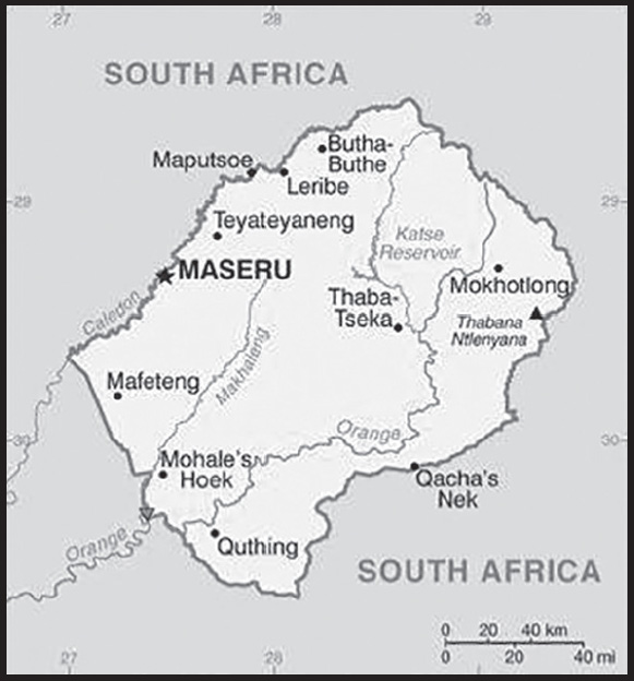
INTRODUCTION
Background: Paramount chief MOSHOESHOE I consolidated what would become Basutoland in the early 19th century and made himself king in 1822. Continuing encroachments by Dutch settlers from the neighboring Orange Free State caused the king to enter into an 1868 agreement with the UK by which Basutoland became a British protectorate, and after 1884, a crown colony. Upon independence in 1966, the country was renamed the Kingdom of Lesotho. The Basotho National Party ruled the country during its first two decades. King MOSHOESHOE II was exiled in 1990 but returned to Lesotho in 1992 and was reinstated in 1995 and subsequently succeeded by his son, King LETSIE III, in 1996. Constitutional government was restored in 1993 after seven years of military rule. In 1998, violent protests and a military mutiny following a contentious election prompted a brief but bloody intervention by South African and Batswana military forces under the aegis of the Southern African Development Community. Subsequent constitutional reforms restored relative political stability. Peaceful parliamentary elections were held in 2002, but the National Assembly elections in 2007 were hotly contested and aggrieved parties disputed how the electoral law was applied to award proportional seats in the Assembly. In 2012, competitive elections involving 18 parties saw Prime Minister Motsoahae Thomas THABANE form a coalition government - the first in the country’s history - that ousted the 14-year incumbent, Pakalitha MOSISILI, who peacefully transferred power the following month. MOSISILI returned to power in snap elections in February 2015 after the collapse of THABANE’s coalition government and an alleged attempted military coup. In June 2017, THABANE returned to become prime minister but stepped down in May 2020 after being implicated in his estranged wife’s murder. He was succeeded by Moseketsi MAJORO. In November 2022, Ntsokoane Samuel MATEKANE was inaugurated as prime minister as head of a three-party coalition featuring his Revolution for Prosperity (RFP), the Monyane MOLELEKI-led Alliance of Democrats (AD), and the Selibe MOCHOBOROANE-led Movement for Economic Change (MEC).
GEOGRAPHY
Location: Southern Africa, an enclave of South Africa
Geographic coordinates: 29 30 S, 28 30 E
Map references: Africa
Area: total: 30,355 sq km
land: 30,355 sq km
water: 0 sq km
comparison ranking: total 141
Area - comparative: slightly smaller than Maryland
Land boundaries: total: 1,106 km
border countries (1): South Africa 1,106 km
Coastline: 0 km (landlocked)
Maritime claims: none (landlocked)
Climate: temperate; cool to cold, dry winters; hot, wet summers
Terrain: mostly highland with plateaus, hills, and mountains
Elevation: highest point: Thabana Ntlenyana 3,482 m
lowest point: junction of the Orange and Makhaleng Rivers 1,400 m
mean elevation: 2,161 m
Natural resources: water, agricultural and grazing land, diamonds, sand, clay, building stone
Land use: agricultural land: 76.1% (2018 est.)
arable land: 10.1% (2018 est.)
permanent crops: 0.1% (2018 est.)
permanent pasture: 65.9% (2018 est.)
forest: 1.5% (2018 est.)
other: 22.4% (2018 est.)
Irrigated land: 12 sq km (2013)
Major rivers (by length in km): Orange river source (shared with South Africa and Namibia [m]) - 2,092 km
note – [s] after country name indicates river source; [m] after country name indicates river mouth
Major watersheds (area sq km): Atlantic Ocean drainage: Orange (941,351 sq km)
Population distribution: relatively higher population density in the western half of the nation, with the capital of Maseru, and the smaller cities of Mafeteng, Teyateyaneng, and Leribe attracting the most people as shown in this population distribution map
Natural hazards: periodic droughts
Geography - note: landlocked, an enclave of (completely surrounded by) South Africa; mountainous, more than 80% of the country is 1,800 m above sea level
PEOPLE AND SOCIETY
Population: 2,210,646 (2023 est.)
comparison ranking: 147
Nationality: noun: Mosotho (singular), Basotho (plural)
adjective: Basotho
Ethnic groups: Sotho 99.7%, other 0.3% (includes San, Kwena, Nguni (Hlubi and Phuthi), Zulu)
Languages: Sesotho (official) (southern Sotho), English (official), Phuthi, Xhosa, Zulu
Religions: Protestant 47.8% (Pentecostal 23.1%, Lesotho Evangelical 17.3%, Anglican 7.4%), Roman Catholic 39.3%, other Christian 9.1%, non-Christian 1.4%, none 2.3% (2014 est.)
Demographic profile: Lesotho faces great socioeconomic challenges. Almost half of its population lives below the poverty line as of 2017, and the country’s HIV/AIDS prevalence rate is the second highest in the world as of 2021. In addition, Lesotho is a small, mountainous, landlocked country with little arable land, leaving its population vulnerable to food shortages and reliant on remittances. Lesotho’s persistently high infant, child, and maternal mortality rates have been increasing during the last decade, according to the last two Demographic and Health Surveys. Despite these significant shortcomings, Lesotho has made good progress in education; it is on-track to achieve universal primary education and has one of the highest adult literacy rates in Africa.
Lesotho’s migration history is linked to its unique geography; it is surrounded by South Africa with which it shares linguistic and cultural traits. Lesotho at one time had more of its workforce employed outside its borders than any other country. Today remittances equal about 20% of its GDP. With few job options at home, a high rate of poverty, and higher wages available across the border, labor migration to South Africa replaced agriculture as the prevailing Basotho source of income decades ago. The majority of Basotho migrants were single men contracted to work as gold miners in South Africa. However, migration trends changed in the 1990s, and fewer men found mining jobs in South Africa because of declining gold prices, stricter immigration policies, and a preference for South African workers.
Although men still dominate cross-border labor migration, more women are working in South Africa, mostly as domestics, because they are widows or their husbands are unemployed. Internal rural-urban flows have also become more frequent, with more women migrating within the country to take up jobs in the garment industry or moving to care for loved ones with HIV/AIDS. Lesotho’s small population of immigrants is increasingly composed of Taiwanese and Chinese migrants who are involved in the textile industry and small retail businesses.
Age structure: 0-14 years: 32.4% (male 360,327/female 355,863)
15-64 years: 62.21% (male 688,373/female 686,911)
65 years and over: 5.39% (2023 est.) (male 44,313/female 74,859)
Dependency ratios: total dependency ratio: 62.1
youth dependency ratio: 55.3
elderly dependency ratio: 6.8
potential support ratio: 14.7 (2021 est.)
Median age: total: 24.7 years (2020)
male: 24.7 years
female: 24.7 years
comparison ranking: total 164
Population growth rate: 0.76% (2023 est.)
comparison ranking: 117
Birth rate: 23.01 births/1,000 population (2023 est.)
comparison ranking: 49
Death rate: 10.9 deaths/1,000 population (2023 est.)
comparison ranking: 23
Net migration rate: -4.52 migrant(s)/1,000 population (2023 est.)
comparison ranking: 199
Population distribution: relatively higher population density in the western half of the nation, with the capital of Maseru, and the smaller cities of Mafeteng, Teyateyaneng, and Leribe attracting the most people as shown in this population distribution map
Urbanization: urban population: 30.4% of total population (2023)
rate of urbanization: 2.77% annual rate of change (2020-25 est.)
Major urban areas - population: 202,000 MASERU (capital) (2018)
Sex ratio: at birth: 1.03 male(s)/female
0-14 years: 1.01 male(s)/female
15-64 years: 1 male(s)/female
65 years and over: 0.59 male(s)/female
total population: 0.98 male(s)/female (2023 est.)
Mother’s mean age at first birth: 20.9 years (2014 est.)
note: data represents median age at first birth among women 25-49
Maternal mortality ratio: 566 deaths/100,000 live births (2020 est.)
comparison ranking: 9
Infant mortality rate: total: 47.04 deaths/1,000 live births (2023 est.)
male: 52.47 deaths/1,000 live births
female: 41.44 deaths/1,000 live births
comparison ranking: total 23
Life expectancy at birth: total population: 59.87 years (2023 est.)
male: 57.85 years
female: 61.95 years
comparison ranking: total population 220
Total fertility rate: 2.88 children born/woman (2023 est.)
comparison ranking: 51
Gross reproduction rate: 1.42 (2023 est.)
Contraceptive prevalence rate: 64.9% (2018)
Drinking water source: improved: urban: 95.7% of population
rural: 77.2% of population
total: 82.6% of population
unimproved: urban: 4.3% of population
rural: 22.8% of population
total: 17.4% of population (2020 est.)
Current health expenditure: 11.8% of GDP (2020)
Physicians density: 0.47 physicians/1,000 population (2018)
Sanitation facility access: improved: urban: 93.6% of population
rural: 62.4% of population
total: 71.4% of population
unimproved: urban: 6.4% of population
rural: 37.6% of population
total: 28.6% of population (2020 est.)
Major infectious diseases: degree of risk: intermediate (2023)
food or waterborne diseases: bacterial diarrhea, hepatitis A, and typhoid fever
Obesity - adult prevalence rate: 16.6% (2016)
comparison ranking: 121
Alcohol consumption per capita: total: 3.56 liters of pure alcohol (2019 est.)
beer: 1.98 liters of pure alcohol (2019 est.)
wine: 0.44 liters of pure alcohol (2019 est.)
spirits: 0.31 liters of pure alcohol (2019 est.)
other alcohols: 0.82 liters of pure alcohol (2019 est.)
comparison ranking: total 103
Tobacco use: total: 24.3% (2020 est.)
male: 43.1% (2020 est.)
female: 5.4% (2020 est.)
comparison ranking: total 55
Children under the age of 5 years underweight: 10.5% (2018)
comparison ranking: 55
Currently married women (ages 15-49): 53.7% (2023 est.)
Child marriage: women married by age 15: 1%
women married by age 18: 16.4%
men married by age 18: 1.9% (2018 est.)
Education expenditures: 8.7% of GDP (2021 est.)
comparison ranking: 11
Literacy: definition: age 15 and over can read and write
total population: 81%
male: 72.9%
female: 88.8% (2021)
School life expectancy (primary to tertiary education): total: 12 years
male: 12 years
female: 13 years (2017)
Youth unemployment rate (ages 15-24): total: 37.4% (2021 est.)
male: 32.8%
female: 43.8%
comparison ranking: total 20
ENVIRONMENT
Environment - current issues: population pressure forcing settlement in marginal areas results in overgrazing, severe soil erosion, and soil exhaustion; desertification; Highlands Water Project controls, stores, and redirects water to South Africa
Environment - international agreements: party to: Biodiversity, Climate Change, Climate Change-Kyoto Protocol, Climate Change-Paris Agreement, Comprehensive Nuclear Test Ban, Desertification, Endangered Species, Hazardous Wastes, Law of the Sea, Marine Life Conservation, Ozone Layer Protection, Wetlands
signed, but not ratified: none of the selected agreements
Climate: temperate; cool to cold, dry winters; hot, wet summers
Land use: agricultural land: 76.1% (2018 est.)
arable land: 10.1% (2018 est.)
permanent crops: 0.1% (2018 est.)
permanent pasture: 65.9% (2018 est.)
forest: 1.5% (2018 est.)
other: 22.4% (2018 est.)
Urbanization: urban population: 30.4% of total population (2023)
rate of urbanization: 2.77% annual rate of change (2020-25 est.)
Food insecurity: severe localized food insecurity: due to poor harvests and increased food prices - according to the latest national food security assessment, 22% of the rural population are expected to face acute food insecurity between October 2022 and March 2023, compared to 15% between July and September 2022; the forecasted proportion translates into 320,000 people in rural areas, while an additional 201,000 people in urban areas are foreseen to also need assistance; the foreseen increase of acute food insecurity levels is primarily due to the reduced harvest, high food prices in basic food and non-food commodities and a slow recovery of households’ income reflecting a downturn in economic growth; harvesting of the 2022 main-season summer cereal crops, mostly maize and sorghum, is complete; production of maize, the main cereal staple, is about one-third of the average, while the sorghum output is almost negligible; the poor harvest was primarily due to torrential rainfalls during January and February 2022, which caused localized flooding and resulted in crop losses (2022)
Revenue from forest resources: 3.34% of GDP (2018 est.)
comparison ranking: 22
Revenue from coal: 0% of GDP (2018 est.)
comparison ranking: 96
Air pollutants: particulate matter emissions: 17.6 micrograms per cubic meter (2019 est.)
carbon dioxide emissions: 2.51 megatons (2016 est.)
methane emissions: 2.56 megatons (2020 est.)
Waste and recycling: municipal solid waste generated annually: 73,457 tons (2006 est.)
Major rivers (by length in km): Orange river source (shared with South Africa and Namibia [m]) - 2,092 km
note – [s] after country name indicates river source; [m] after country name indicates river mouth
Major watersheds (area sq km): Atlantic Ocean drainage: Orange (941,351 sq km)
Total water withdrawal: municipal: 20 million cubic meters (2020 est.)
industrial: 20 million cubic meters (2020 est.)
agricultural: 3.8 million cubic meters (2017 est.)
Total renewable water resources: 3.02 billion cubic meters (2020 est.)
GOVERNMENT
Country name: conventional long form: Kingdom of Lesotho
conventional short form: Lesotho
local long form: Kingdom of Lesotho
local short form: Lesotho
former: Basutoland
etymology: the name translates as “Land of the Sesotho Speakers”
Government type: parliamentary constitutional monarchy
Capital: name: Maseru
geographic coordinates: 29 19 S, 27 29 E
time difference: UTC+2 (7 hours ahead of Washington, DC, during Standard Time)
etymology: in the Sesotho language the name means “[place of] red sandstones”
Administrative divisions: 10 districts; Berea, Butha-Buthe, Leribe, Mafeteng, Maseru, Mohale’s Hoek, Mokhotlong, Qacha’s Nek, Quthing, Thaba-Tseka
Independence: 4 October 1966 (from the UK)
National holiday: Independence Day, 4 October (1966)
Constitution: history: previous 1959, 1967; latest adopted 2 April 1993 (effectively restoring the 1967 version)
amendments: proposed by Parliament; passage of amendments affecting constitutional provisions, including fundamental rights and freedoms, sovereignty of the kingdom, the office of the king, and powers of Parliament, requires a majority vote by the National Assembly, approval by the Senate, approval in a referendum by a majority of qualified voters, and assent of the king; passage of amendments other than those specified provisions requires at least a two-thirds majority vote in both houses of Parliament; amended several times, last in 2011
Legal system: mixed legal system of English common law and Roman-Dutch law; judicial review of legislative acts in High Court and Court of Appeal
International law organization participation: accepts compulsory ICJ jurisdiction with reservations; accepts ICCt jurisdiction
Citizenship: citizenship by birth: yes
citizenship by descent only: yes
dual citizenship recognized: no
residency requirement for naturalization: 5 years
Suffrage: 18 years of age; universal
Executive branch: chief of state: King LETSIE III (since 7 February 1996); note - King LETSIE III formerly occupied the throne from November 1990 to February 1995 while his father was in exile
head of government: Prime Minister Ntsokoane Samuel MATEKANE (4 November 2022)
cabinet: consists of the prime minister, appointed by the King on the advice of the Council of State, the deputy prime minister, and 15 other ministers
elections/appointments: the monarchy is hereditary, but under the terms of the constitution that came into effect after the March 1993 election, the monarch is a “living symbol of national unity” with no executive or legislative powers; under traditional law, the College of Chiefs has the power to depose the monarch, to determine next in line of succession, or to serve as regent in the event that a successor is not of mature age; following legislative elections, the leader of the majority party or majority coalition in the Assembly automatically becomes prime minister
Legislative branch: description: bicameral Parliament consists of:
Senate (33 seats; 22 principal chiefs and 11 other senators nominated by the king with the advice of the Council of State, a 13-member body of key government and non-government officials; members serve 5-year terms) National Assembly (120 seats; 80 members directly elected in single-seat constituencies by simple majority vote and 40 elected through proportional representation; members serve 5-year terms)
elections:
Senate - last nominated by the king on July 2022 (next to be held in late July 2027) National Assembly - last held on 7 October 2022 (next to be held in October 2027)
election results:
Senate - percent of votes by party - NA, seats by party - NA; composition - men 26, women 7, percent of women 21.2%
National Assembly - percent of votes by party - RFP 38.9%, DC 24.7%, ABC 7.1%, BAP 5.4%, AD 4.0%, MEC 3.2%, LCD 2.3%, SR 2.1%, BNP 1.4%, PFD 0.9%, BCM 0.8%, MPS 0.8%, MIP 0.7%; seats by party - RFP 56, DC 29, ABC 8, BAP 6, AD 5, MEC 4, LCD 3, SR 2, BNP 1, PFD 1, BCM 1, MPS 1, NIP 1, HOPE 1, TBD 1; composition - men 87, women 28, percent of women 23.3%; note - total Parliament percent of women 22.9%
Judicial branch: highest court(s): Court of Appeal (consists of the court president, such number of justices of appeal as set by Parliament, and the Chief Justice and the puisne judges of the High Court ex officio); High Court (consists of the chief justice and such number of puisne judges as set by Parliament); note - both the Court of Appeal and the High Court have jurisdiction in constitutional issues
judge selection and term of office: Court of Appeal president and High Court chief justice appointed by the monarch on the advice of the prime minister; puisne judges appointed by the monarch on advice of the Judicial Service Commission, an independent body of judicial officers and officials designated by the monarch; judges of both courts can serve until age 75
subordinate courts: Magistrate Courts; customary or traditional courts; military courts
Political parties and leaders: All Basotho Convention or ABC [Nkaku KABI]
Alliance of Democrats or AD [Monyane MOLELEKI]
Basotho Action Party or BAP [Nqosa MAHAO]
Basotho National Party or BNP [Thesele MASERIBANE]
Democratic Congress or DC [Mathibeli MOKHOTHU]
Democratic Party of Lesotho or DPL [Limpho TAU]
Lesotho Congress for Democracy or LCD [Mothetjoa METSING]
Lesotho People’s Congress or LPC [Mabusetsa MAKHARILELEJ]
Movement of Economic Change or MEC [Selibe MOCHOBOROANE]
National Independent Party or NIP [Kimetso MATHABA]
Popular Front for Democracy of PFD [Lekhetho RAKUOANE]
Reformed Congress of Lesotho or RCL [Keketso RANTSO]
International organization participation: ACP, AfDB, AU, C, CD, FAO, G-77, IAEA, IBRD, ICAO, ICCt, ICRM, IDA, IFAD, IFC, IFRCS, ILO, IMF, Interpol, IOC, IOM, IPU, ISO (correspondent), ITU, MIGA, NAM, OPCW, SACU, SADC, UN, UNCTAD, UNESCO, UNHCR, UNIDO, UNWTO, UPU, WCO, WFTU (NGOs), WHO, WIPO, WMO, WTO
Diplomatic representation in the US: chief of mission: Ambassador Tumisang MOSOTHO (since 16 September 2022)
chancery: 2511 Massachusetts Avenue NW, Washington, DC 20008
telephone: [1] (202) 797-5533
FAX: [1] (202) 234-6815
email address and website: lesothoembassy@verizon.net
Diplomatic representation from the US: chief of mission: Ambassador Maria E. BREWER (since 10 March 2022)
embassy: 254 Kingsway Avenue, Maseru
mailing address: 2340 Maseru Place, Washington DC 20521-2340
telephone: [266] 22312666
FAX: [266] 22310116
email address and website:
Flag description: three horizontal stripes of blue (top), white, and green in the proportions of 3:4:3; the colors represent rain, peace, and prosperity respectively; centered in the white stripe is a black mokorotlo, a traditional Basotho straw hat and national symbol; the redesigned flag was unfurled in October 2006 to celebrate 40 years of independence
National symbol(s): mokorotio (Basotho hat); national colors: blue, white, green, black
National anthem: name: “Lesotho fatse la bo ntat’a rona” (Lesotho, Land of Our Fathers)
lyrics/music: Francois COILLARD/Ferdinand-Samuel LAUR
note: adopted 1967; music derives from an 1823 Swiss songbook
National heritage: total World Heritage Sites: 1 (mixed)
selected World Heritage Site locales: Maloti-Drakensberg Park
ECONOMY
Economic overview: lower middle-income economy surrounded by South Africa; environmentally fragile and politically unstable; key infrastructure and renewable energy investments; dire poverty; urban job and income losses due to COVID-19; systemic corruption
Real GDP (purchasing power parity): $5.236 billion (2021 est.)
$5.167 billion (2020 est.)
$5.638 billion (2019 est.)
note: data are in 2017 dollars
comparison ranking: 178
Real GDP growth rate: 1.35% (2021 est.)
-8.36% (2020 est.)
0.93% (2019 est.)
comparison ranking: 179
Real GDP per capita: $2,300 (2021 est.)
$2,300 (2020 est.)
$2,500 (2019 est.)
note: data are in 2017 dollars
comparison ranking: 204
GDP (official exchange rate): $2.462 billion (2019 est.)
Inflation rate (consumer prices): 6.05% (2021 est.)
4.98% (2020 est.)
5.19% (2019 est.)
comparison ranking: 51
Credit ratings: Fitch rating: B (2019)
note: The year refers to the year in which the current credit rating was first obtained.
GDP - composition, by sector of origin: agriculture: 5.8% (2016 est.)
industry: 39.2% (2016 est.)
services: 54.9% (2017 est.)
comparison rankings: services 155; industry 34; agriculture 121
GDP - composition, by end use: household consumption: 69.2% (2017 est.)
government consumption: 26.4% (2017 est.)
investment in fixed capital: 31.4% (2017 est.)
investment in inventories: -13.4% (2017 est.)
exports of goods and services: 40.8% (2017 est.)
imports of goods and services: -54.4% (2017 est.)
Agricultural products: milk, potatoes, maize, vegetables, fruit, beef, game meat, mutton, beans, wool
Industries: food, beverages, textiles, apparel assembly, handicrafts, construction, tourism
Industrial production growth rate: 8.52% (2021 est.)
comparison ranking: 44
Labor force: 955,600 (2021 est.)
comparison ranking: 145
Labor force - by occupation: agriculture: 86%
industry and services: 14% (2002 est.)
note: most of the resident population is engaged in subsistence agriculture; roughly 35% of the active male wage earners work in South Africa
Unemployment rate: 24.6% (2021 est.)
24.56% (2020 est.)
22.44% (2019 est.)
comparison ranking: 11
Youth unemployment rate (ages 15-24): total: 37.4% (2021 est.)
male: 32.8%
female: 43.8%
comparison ranking: total 20
Population below poverty line: 49.7% (2017 est.)
Gini Index coefficient - distribution of family income: 44.9 (2017 est.)
56 (1986-87)
comparison ranking: 28
Household income or consumption by percentage share: lowest 10%: 1%
highest 10%: 39.4% (2003)
Budget: revenues: $1.054 billion (2020 est.)
expenditures: $1.21 billion (2020 est.)
Budget surplus (+) or deficit (-): -6% (of GDP) (2017 est.)
comparison ranking: 182
Public debt: 33.7% of GDP (2017 est.)
36.2% of GDP (2016 est.)
comparison ranking: 158
Taxes and other revenues: 18.47% (of GDP) (2020 est.)
comparison ranking: 107
Fiscal year: 1 April - 31 March
Current account balance: -$90.886 million (2021 est.)
-$18.211 million (2020 est.)
-$72.308 million (2019 est.)
comparison ranking: 90
Exports: $1.08 billion (2021 est.) note: data are in current year dollars
$902.123 million (2020 est.) note: data are in current year dollars
$1.093 billion (2019 est.) note: data are in current year dollars
comparison ranking: 176
Exports - partners: United States 29%, Belgium 26%, South Africa 25%, Switzerland 6% (2019)
Exports - commodities: diamonds, clothing and apparel, wool, low-voltage protection equipment, wheat flours (2021)
Imports: $2.221 billion (2021 est.) note: data are in current year dollars
$1.98 billion (2020 est.) note: data are in current year dollars
$2.23 billion (2019 est.) note: data are in current year dollars
comparison ranking: 169
Imports - partners: South Africa 85%, China 5% (2019)
Imports - commodities: refined petroleum, clothing and apparel, packaged medicines, delivery trucks, poultry meats (2019)
Reserves of foreign exchange and gold: $774.095 million (31 December 2019 est.)
$728.528 million (31 December 2018 est.)
$657.668 million (31 December 2017 est.)
comparison ranking: 156
Debt - external: $868 million (2019 est.)
$834 million (2018 est.)
comparison ranking: 166
Exchange rates: maloti (LSL) per US dollar -
Exchange rates:: 14.779 (2021 est.)
16.459 (2020 est.)
14.448 (2019 est.)
13.234 (2018 est.)
13.324 (2017 est.)
ENERGY
Electricity access: population without electricity: 1 million (2020)
electrification - total population: 50.3% (2021)
electrification - urban areas: 80.6% (2021)
electrification - rural areas: 37.7% (2021)
Electricity: installed generating capacity: 74,000 kW (2020 est.)
consumption: 912.8 million kWh (2019 est.)
exports: 0 kWh (2019 est.)
imports: 541.7 million kWh (2019 est.)
transmission/distribution losses: 129.9 million kWh (2019 est.)
comparison rankings: installed generating capacity 188; transmission/distribution losses 157; imports 84; exports 138; consumption 162
Electricity generation sources: solar: 0.2% of total installed capacity (2020 est.)
hydroelectricity: 99.8% of total installed capacity (2020 est.)
Petroleum: total petroleum production: 0 bbl/day (2021 est.)
refined petroleum consumption: 5,100 bbl/day (2019 est.)
Refined petroleum products - imports: 5,118 bbl/day (2015 est.)
comparison ranking: 170
Carbon dioxide emissions: 736,000 metric tonnes of CO2 (2019 est.)
from petroleum and other liquids: 736,000 metric tonnes of CO2 (2019 est.)
comparison ranking: total emissions 181
Energy consumption per capita: 7.823 million Btu/person (2019 est.)
comparison ranking: 164
COMMUNICATIONS
Telephones - fixed lines: total subscriptions: 9,559 (2021 est.)
subscriptions per 100 inhabitants: (2021 est.) less than 1
comparison ranking: total subscriptions 192
Telephones - mobile cellular: total subscriptions: 1,821,374 (2021 est.)
subscriptions per 100 inhabitants: 80 (2021 est.)
comparison ranking: total subscriptions 154
Telecommunication systems: general assessment: until late 2020, Lesotho’s telecom regulator maintained a market duopoly which is focused on fixed-line services; competition was insufficient to promote effective price reductions for consumers, while the regulator had no mechanisms in place to monitor the telcos to ensure quality of service and fair pricing for consumers; the small size of the country’s population provided little incentive for new players to enter the market; a positive outcome for consumers was the deployment in early 2021 of a service to monitor traffic and billing; this ended the practice whereby the regulator was dependent on telcos submitting data about their performance, billing, and other matters; the regulator has also turned its attention to addressing multiple SIM ownership and stem incidences of crimes committed using unregistered SIMs; in May 2022, it instructed the country’s MNOs to begin registering SIM cards on their networks from the following month; fixed-wireless 5G trials began in early 2019 (2022)
domestic: fixed-line is less than 1 per 100 subscriptions; mobile-cellular service subscribership is 80 per 100 persons (2021)
international: country code - 266; Internet accessibility has improved with several submarine fiber optic cables that land on African east and west coasts, but the country’s land locked position makes access prices expensive; satellite earth station - 1 Intelsat (Atlantic Ocean) (2019)
Broadcast media: 1 state-owned TV station and 2 state-owned radio stations; government controls most private broadcast media; satellite TV subscription service available; transmissions of multiple international broadcasters obtainable (2019)
Internet country code: .ls
Internet users: total: 1.104 million (2021 est.)
percent of population: 48% (2021 est.)
comparison ranking: total 148
Broadband - fixed subscriptions: total: 5,060 (2020 est.)
subscriptions per 100 inhabitants: 0.2 (2020 est.)
comparison ranking: total 185
TRANSPORTATION
Civil aircraft registration country code prefix: 7P
Airports: 24 (2021)
comparison ranking: total 131
Airports - with paved runways: 3
note: paved runways have a concrete or asphalt surface but not all have facilities for refueling, maintenance, or air traffic control; the length of a runway required for aircraft to safely operate depends on a number of factors including the type of aircraft, the takeoff weight (including passengers, cargo, and fuel), engine types, flap settings, landing speed, elevation of the airport, and average maximum daily air temperature; paved runways can reach a length of 5,000 m (16,000 ft.), but the “typical” length of a commercial airline runway is between 2,500-4,000 m (8,000-13,000 ft.)
Airports - with unpaved runways: 21
note: unpaved runways have a surface composition such as grass or packed earth and are most suited to the operation of light aircraft; unpaved runways are usually short, often less than 1,000 m (3,280 ft.) in length; airports with unpaved runways often lack facilities for refueling, maintenance, or air traffic control
Roadways: total: 5,940 km (2011)
paved: 1,069 km (2011)
unpaved: 4,871 km (2011)
comparison ranking: total 144
MILITARY AND SECURITY
Military and security forces: Lesotho Defense Force (LDF): Army (includes Air Wing) (2023)
note: the Lesotho Mounted Police Service is responsible for internal security and reports to the Minister of Police and Public Safety
Military expenditures: 1.6% of GDP (2022 est.)
1.5% of GDP (2021 est.)
1.6% of GDP (2020 est.)
1.8% of GDP (2019 est.)
2.1% of GDP (2018 est.)
comparison ranking: 81
Military and security service personnel strengths: approximately 2,000 personnel (2023)
Military equipment inventories and acquisitions: the LDF has a small inventory of older and second-hand equipment from a variety of countries (2023)
Military service age and obligation: 20-30 years of age for voluntary military service for both men and women (women can serve in combat arms); no conscription (2023)
Military - note: Lesotho’s declared policy for its military is the maintenance of the country’s sovereignty and the preservation of internal security; in practice, external security is guaranteed by South Africa; the LDF is a small force comprised of about a half dozen infantry companies; it began in 1964 as the Police Mobile Unit (PMU); the PMU was designated as the Lesotho Paramilitary Force in 1980 and became the Royal Lesotho Defense Force in 1986; it was subsequently renamed the Lesotho Defense Force in 1993 (2023)
TRANSNATIONAL ISSUES
Disputes - international: Lesotho-South Africa: South Africa has placed military units to assist police operations along the border of Lesotho, Zimbabwe, and Mozambique to control smuggling, poaching, and illegal migration
INTRODUCTION
Background: With 28 ethnic groups and languages, Liberia is one of the most ethnically diverse countries in the world. For hundreds of years, the Mali and Songhai Empires claimed most of Liberia. Beginning in the 15th century, European traders began establishing outposts along the Liberian coast. Unlike its neighbors, however, Liberia did not fall under European colonial rule. In the early 19th century, the US began sending freed enslaved people and other people of color to Liberia to establish settlements. In 1847, these settlers declared independence from the US, writing their own constitution and establishing Africa’s first republic.
Early in Liberia’s history, tensions arose between the Americo-Liberian settlers and the indigenous population. In 1980, Samuel DOE, who was from the indigenous population, led a military coup and ushered in a decade of authoritarian rule. In December 1989, Charles TAYLOR launched a rebellion against DOE’s regime that led to a prolonged civil war in which DOE was killed. A period of relative peace in 1997 permitted an election that brought TAYLOR to power. In 2000, fighting resumed. An August 2003 peace agreement ended the war and prompted President TAYLOR’s resignation. TAYLOR was later convicted by the UN-backed Special Court for Sierra Leone in The Hague for his involvement in Sierra Leone’s civil war. In late 2005, President Ellen JOHNSON SIRLEAF became president after two years of transitional governments; she was the first female head of state in Africa. In 2011, JOHNSON SIRLEAF won reelection but struggled to rebuild Liberia’s economy, particularly following the 2014-15 Ebola epidemic, and to reconcile a nation still recovering from 14 years of fighting. In 2017, former soccer star George WEAH won the presidential runoff election, marking the first successful transfer of power from one democratically elected government to another since the end of Liberia’s civil wars. Like his predecessor, WEAH has struggled to improve the country’s economy. The next presidential election is scheduled for 2023.
GEOGRAPHY
Location: Western Africa, bordering the North Atlantic Ocean, between Cote d’Ivoire and Sierra Leone
Geographic coordinates: 6 30 N, 9 30 W
Map references: Africa
Area: total: 111,369 sq km
land: 96,320 sq km
water: 15,049 sq km
comparison ranking: total 104
Area - comparative: slightly larger than Virginia
Land boundaries: total: 1,667 km
border countries (3): Guinea 590 km; Cote d’Ivoire 778 km; Sierra Leone 299 km
Coastline: 579 km
Maritime claims: territorial sea: 12 nm
contiguous zone: 24 nm
exclusive economic zone: 200 nm
continental shelf: 200 nm
Climate: tropical; hot, humid; dry winters with hot days and cool to cold nights; wet, cloudy summers with frequent heavy showers
Terrain: mostly flat to rolling coastal plains rising to rolling plateau and low mountains in northeast
Elevation: highest point: Mount Wuteve 1,447 m
lowest point: Atlantic Ocean 0 m
mean elevation: 243 m
Natural resources: iron ore, timber, diamonds, gold, hydropower
Land use: agricultural land: 28.1% (2018 est.)
arable land: 5.2% (2018 est.)
permanent crops: 2.1% (2018 est.)
permanent pasture: 20.8% (2018 est.)
forest: 44.6% (2018 est.)
other: 27.3% (2018 est.)
Irrigated land: 30 sq km (2012)
Population distribution: more than half of the population lives in urban areas, with approximately one-third living within an 80-km radius of Monrovia as shown in this population distribution map
Natural hazards: dust-laden harmattan winds blow from the Sahara (December to March)
Geography - note: facing the Atlantic Ocean, the coastline is characterized by lagoons, mangrove swamps, and river-deposited sandbars; the inland grassy plateau supports limited agriculture
PEOPLE AND SOCIETY
Population: 5,506,280 (2023 est.)
comparison ranking: 120
Nationality: noun: Liberian(s)
adjective: Liberian
Ethnic groups: Kpelle 20.3%, Bassa 13.4%, Grebo 10%, Gio 8%, Mano 7.9%, Kru 6%, Lorma 5.1%, Kissi 4.8%, Gola 4.4%, Krahn 4%, Vai 4%, Mandingo 3.2%, Gbandi 3%, Mende 1.3%, Sapo 1.3%, other Liberian 1.7%, other African 1.4%, non-African 0.1% (2008 est.)
Languages: English 20% (official), some 20 ethnic group languages few of which can be written or used in correspondence
Religions: Christian 85.6%, Muslim 12.2%, Traditional 0.6%, other 0.2%, none 1.5% (2008 est.)
Demographic profile: Liberia’s high fertility rate of nearly 5 children per woman and large youth cohort – more than 60% of the population is under the age of 25 as of 2020 – will sustain a high dependency ratio for many years to come. Significant progress has been made in preventing child deaths, despite a lack of health care workers and infrastructure. Infant and child mortality have dropped nearly 70% since 1990; the annual reduction rate of about 5.4% is the highest in Africa.
Nevertheless, Liberia’s high maternal mortality rate remains among the world’s worst; it reflects a high unmet need for family planning services, frequency of early childbearing, lack of quality obstetric care, high adolescent fertility, and a low proportion of births attended by a medical professional. Female mortality is also increased by the prevalence of female genital cutting (FGC), which is practiced by 10 of Liberia’s 16 tribes and affects more than two-thirds of women and girls. FGC is an initiation ritual performed in rural bush schools, which teach traditional beliefs on marriage and motherhood and are an obstacle to formal classroom education for Liberian girls.
Liberia has been both a source and a destination for refugees. During Liberia’s 14-year civil war (1989-2003), more than 250,000 people became refugees and another half million were internally displaced. Between 2004 and the cessation of refugee status for Liberians in June 2012, the UNHCR helped more than 155,000 Liberians to voluntarily repatriate, while others returned home on their own. Some Liberian refugees spent more than two decades living in other West African countries. Between 2011 and 2022, more than 300,000 Ivoirian refugees in Liberia have been repatriated; as of year-end 2022, less than 2,300 Ivoirian refugees were still living in Liberia.
Age structure: 0-14 years: 42.69% (male 1,187,795/female 1,162,699)
15-64 years: 54.5% (male 1,486,582/female 1,514,163)
65 years and over: 2.82% (2023 est.) (male 75,258/female 79,783)
Dependency ratios: total dependency ratio: 79.7
youth dependency ratio: 73.7
elderly dependency ratio: 6
potential support ratio: 16.7 (2021 est.)
Median age: total: 18 years (2020)
male: 17.7 years
female: 18.2 years
comparison ranking: total 213
Population growth rate: 2.71% (2023 est.)
comparison ranking: 16
Birth rate: 36.26 births/1,000 population (2023 est.)
comparison ranking: 11
Death rate: 6.46 deaths/1,000 population (2023 est.)
comparison ranking: 138
Net migration rate: -2.67 migrant(s)/1,000 population (2023 est.)
comparison ranking: 177
Population distribution: more than half of the population lives in urban areas, with approximately one-third living within an 80-km radius of Monrovia as shown in this population distribution map
Urbanization: urban population: 53.6% of total population (2023)
rate of urbanization: 3.41% annual rate of change (2015-20 est.)
Major urban areas - population: 1.678 million MONROVIA (capital) (2023)
Sex ratio: at birth: 1.03 male(s)/female
0-14 years: 1.02 male(s)/female
15-64 years: 0.98 male(s)/female
65 years and over: 0.94 male(s)/female
total population: 1 male(s)/female (2023 est.)
Mother’s mean age at first birth: 19.1 years (2019/20 est.)
note: data represents median age at first birth among women 25-49
Maternal mortality ratio: 652 deaths/100,000 live births (2020 est.)
comparison ranking: 6
Infant mortality rate: total: 43.2 deaths/1,000 live births (2023 est.)
male: 47.23 deaths/1,000 live births
female: 39.05 deaths/1,000 live births
comparison ranking: total 28
Life expectancy at birth: total population: 65.8 years (2023 est.)
male: 63.52 years
female: 68.15 years
comparison ranking: total population 201
Total fertility rate: 4.73 children born/woman (2023 est.)
comparison ranking: 13
Gross reproduction rate: 2.33 (2023 est.)
Contraceptive prevalence rate: 24.9% (2019/20)
Drinking water source: improved: urban: 96.2% of population
rural: 70.6% of population
total: 84% of population
unimproved: urban: 3.8% of population
rural: 29.4% of population
total: 16% of population (2020 est.)
Current health expenditure: 9.5% of GDP (2020)
Physicians density: 0.05 physicians/1,000 population (2018)
Sanitation facility access: improved: urban: 68% of population
rural: 25.2% of population
total: 47.5% of population
unimproved: urban: 32% of population
rural: 74.8% of population
total: 52.5% of population (2020 est.)
Major infectious diseases: degree of risk: very high (2023)
food or waterborne diseases: bacterial and protozoal diarrhea, hepatitis A, and typhoid fever
vectorborne diseases: malaria and dengue fever
water contact diseases: schistosomiasis
animal contact diseases: rabies
aerosolized dust or soil contact diseases: Lassa fever
Obesity - adult prevalence rate: 9.9% (2016)
comparison ranking: 141
Alcohol consumption per capita: total: 3.12 liters of pure alcohol (2019 est.)
beer: 0.38 liters of pure alcohol (2019 est.)
wine: 0.44 liters of pure alcohol (2019 est.)
spirits: 2.28 liters of pure alcohol (2019 est.)
other alcohols: 0.02 liters of pure alcohol (2019 est.)
comparison ranking: total 109
Tobacco use: total: 8.2% (2020 est.)
male: 14.3% (2020 est.)
female: 2% (2020 est.)
comparison ranking: total 148
Children under the age of 5 years underweight: 10.9% (2019/20)
comparison ranking: 54
Currently married women (ages 15-49): 48.7% (2023 est.)
Child marriage: women married by age 15: 5.8%
women married by age 18: 24.9%
men married by age 18: 8.4% (2020 est.)
Education expenditures: 2.7% of GDP (2021 est.)
comparison ranking: 170
Literacy: definition: age 15 and over can read and write
total population: 48.3%
male: 62.7%
female: 34.1% (2017)
Youth unemployment rate (ages 15-24): total: 3.2% (2021 est.)
male: 3.2%
female: 3.2%
comparison ranking: total 197
ENVIRONMENT
Environment - current issues: tropical rain forest deforestation; soil erosion; loss of biodiversity; hunting of endangered species for bushmeat; pollution of coastal waters from oil residue and raw sewage; pollution of rivers from industrial run-off; burning and dumping of household waste
Environment - international agreements: party to: Biodiversity, Climate Change, Climate Change-Kyoto Protocol, Climate Change-Paris Agreement, Comprehensive Nuclear Test Ban, Desertification, Endangered Species, Hazardous Wastes, Law of the Sea, Nuclear Test Ban, Ozone Layer Protection, Ship Pollution, Tropical Timber 2006, Wetlands, Whaling
signed, but not ratified: Environmental Modification, Marine Life Conservation
Climate: tropical; hot, humid; dry winters with hot days and cool to cold nights; wet, cloudy summers with frequent heavy showers
Land use: agricultural land: 28.1% (2018 est.)
arable land: 5.2% (2018 est.)
permanent crops: 2.1% (2018 est.)
permanent pasture: 20.8% (2018 est.)
forest: 44.6% (2018 est.)
other: 27.3% (2018 est.)
Urbanization: urban population: 53.6% of total population (2023)
rate of urbanization: 3.41% annual rate of change (2015-20 est.)
Food insecurity: severe localized food insecurity: due to high food prices and economic downturn - levels of acute food insecurity are expected to increase in 2023 associated with high food prices due to high international commodity prices and elevated transportation costs, exacerbated by the unfolding effects of the war in Ukraine on international trade and commodity prices; food availability and access are likely to remain limited by high food prices and below-average imports; an expected further slowdown in economic domestic growth in 2023 is likely to compound food insecurity conditions for the most vulnerable households; in the June to August 2023 lean season period, over 531,000 people are projected to face acute food insecurity (2023)
Revenue from forest resources: 13.27% of GDP (2018 est.)
comparison ranking: 2
Revenue from coal: 0% of GDP (2018 est.)
comparison ranking: 151
Air pollutants: particulate matter emissions: 35.8 micrograms per cubic meter (2019 est.)
carbon dioxide emissions: 1.39 megatons (2016 est.)
methane emissions: 6.56 megatons (2020 est.)
Waste and recycling: municipal solid waste generated annually: 564,467 tons (2007 est.)
Total water withdrawal: municipal: 80 million cubic meters (2020 est.)
industrial: 50 million cubic meters (2020 est.)
agricultural: 10 million cubic meters (2020 est.)
Total renewable water resources: 232 billion cubic meters (2020 est.)
GOVERNMENT
Country name: conventional long form: Republic of Liberia
conventional short form: Liberia
etymology: name derives from the Latin word “liber” meaning “free”; so named because the nation was created as a homeland for liberated African-American slaves
Government type: presidential republic
Capital: name: Monrovia
geographic coordinates: 6 18 N, 10 48 W
time difference: UTC 0 (5 hours ahead of Washington, DC, during Standard Time)
etymology: named after James MONROE (1758-1831), the fifth president of the United States and supporter of the colonization of Liberia by freed slaves; one of two national capitals named for a US president, the other is Washington, D.C.
Administrative divisions: 15 counties; Bomi, Bong, Gbarpolu, Grand Bassa, Grand Cape Mount, Grand Gedeh, Grand Kru, Lofa, Margibi, Maryland, Montserrado, Nimba, River Cess, River Gee, Sinoe
Independence: 26 July 1847
National holiday: Independence Day, 26 July (1847)
Constitution: history: previous 1847 (at independence); latest drafted 19 October 1983, revision adopted by referendum 3 July 1984, effective 6 January 1986
amendments: proposed by agreement of at least two thirds of both National Assembly houses or by petition of at least 10,000 citizens; passage requires at least two-thirds majority approval of both houses and approval in a referendum by at least two-thirds majority of registered voters; amended 2011, 2020
Legal system: mixed legal system of common law, based on Anglo-American law, and customary law
International law organization participation: accepts compulsory ICJ jurisdiction with reservations; accepts ICCt jurisdiction
Citizenship: citizenship by birth: no
citizenship by descent only: at least one parent must be a citizen of Liberia
dual citizenship recognized: no
residency requirement for naturalization: 2 years
Suffrage: 18 years of age; universal
Executive branch: chief of state: President George WEAH (since 22 January 2018); Vice President Jewel HOWARD-TAYLOR (since 22 January 2018); note - the president is both chief of state and head of government
head of government: President George WEAH (since 22 January 2018); Vice President Jewel HOWARD-TAYLOR (since 22 January 2018)
cabinet: Cabinet appointed by the president, confirmed by the Senate
elections/appointments: president directly elected by absolute majority popular vote in 2 rounds if needed for a 6-year term (eligible for a second term); election last held on 10 October 2023 with a run-off on 14 November 2023 (next to be held October 2028)
election results: Joseph BOAKAI elected president in second round; percent of vote in first round - George WEAH (CDC) 43.8%, Joseph BOAKAI (UP) 43.4%, Edward APPLETON (GDM) 2.20%, Lusinee KAMARA (ALCOP) 1.96%, Alexander B. CUMMINGS, Jr. (CPP) 1.61%, Tiawan Saye GONGLOE (LPP) 1.44%, other 5.59%; percentage of vote in second round - Joseph BOAKAI 50.6%, George WEAH 49.4% note - presidential inauguration in January 2024
Legislative branch: description: bicameral National Assembly consists of:
The Liberian Senate (30 seats; members directly elected in 15 2-seat districts by simple majority vote to serve 9-year staggered terms; each district elects 1 senator and elects the second senator 3 years later, followed by a 6-year hiatus, after which the first Senate seat is up for election)
House of Representatives (73 seats; members directly elected in single-seat districts by simple majority vote to serve 6-year terms; eligible for a second term)
elections:
Senate - general election held on 10 October 2023 with half the seats up for election (next to be held on 9 October 2029)
House of Representatives - last held on 10 October 2023 (next to be held 9 October 2029)
election results:
Senate - percent of vote by party - Collaborating Political Parties 43.3%, Congress for Democratic Change 16.6%, People’s Unification Party 6.6%, Movement for Democracy and Reconstructions 3.3%, National Democratic Coalition 3.3%, National Patriotic Party 3.3%, Independent 23.3%; seats by coalition/party- CPP 13, CDC 5, PUP 2, MDR 1, NDC 1, NPP 1, Independent 7; composition - men 27, women 3, percent of women 11%
House of Representatives - percent of vote by party/coalition - Coalition for Democratic Change 28.7%, Unity Party 27.3%, People’s Unification Party 6.8%, Liberty Party 4.1%, Americo Liberian Party 4.1%, Movement for Democracy and Reconstruction 4.1%, Movement for Economic Empowerment 1.3%, Liberia Transformation Party 1.3%, United People’s Party 1.3%, Victory for Change Party 1.3%, Liberian People’s Party 1.3%, Liberia National Union 1.3%, Independent 17.8%; seats by coalition/party - CDC 21, UP 20, PUP 5, LP 3, ALP 3, MDR 3, MOVEE 1, LTP 1, UPP 1, VCP 1, LPP 1, LNU 1, Independent 13; composition - men 66, women 7, percent of women 9.5%; total Parliament percent of women 9.7%
Judicial branch: highest court(s): Supreme Court (consists of a chief justice and 4 associate justices); note - the Supreme Court has jurisdiction for all constitutional cases
judge selection and term of office: chief justice and associate justices appointed by the president of Liberia with consent of the Senate; judges can serve until age 70
subordinate courts: judicial circuit courts; special courts, including criminal, civil, labor, traffic; magistrate and traditional or customary courts
Political parties and leaders: All Liberian Party or ALP [Benoni UREY]
Alliance for Peace and Democracy or APD [vacant]
Alternative National Congress or ANC [Alexander B. CUMMINGS, JR]
Coalition for Democratic Change [George WEAH] (includes CDC, NPP, and LPDP) Congress for Democratic Change or CDC [George WEAH]
Liberia Destiny Party or LDP [Nathaniel BARNES]
Liberia National Union or LINU [Dr. Clarence K. MONIBA]
Liberia Transformation Party or LTP [Kennedy SANDY]
Liberian People Democratic Party or LPDP [Alex J. TYLER]
Liberian People’s Party or LPP [Henry FAHNBULLEH, JR]
Liberty Party or LP [Charles Brumskine]
Movement for Democracy and Reconstruction or MDR [Prince Y. JOHNSON]
Movement for Economic Empowerment [Joseph JONES]
Movement for Progressive Change or MPC [Simeon FREEMAN]
National Democratic Coalition or NDC [Dew MAYSON]
National Democratic Party of Liberia or NDPL [D. Nyandeh SIEH]
National Patriotic Party or NPP [Jewel HOWARD TAYLOR]
National Reformist Party or NRP [Maximillian T. W. DIABE]
National Union for Democratic Progress or NUDP [Victor BARNEY]
People’s Unification Party or PUP [Isobe GBORKORKOLLIE]
Unity Party or UP [Josephe BOKAI]
United People’s Party [MacDonald WENTO]
Victory for Change Party or VCP [Marcus R. JONES]
International organization participation: ACP, AfDB, AU, ECOWAS, EITI (compliant country), FAO, G-77, IAEA, IBRD, ICAO, ICC (NGOs), ICCt, ICRM, IDA, IFAD, IFC, IFRCS, ILO, IMF, IMO, IMSO, Interpol, IOC, IOM, ISO (correspondent), ITU, ITUC (NGOs), MIGA, MINUSMA, NAM, OPCW, UN, UNCTAD, UNESCO, UNIDO, UNISFA, UNWTO, UPU, WCO, WFTU (NGOs), WHO, WIPO, WMO, WTO (observer)
Diplomatic representation in the US: chief of mission: Ambassador Jeff Gongoer DOWANA (since 12 December 2022)
chancery: 5201 16th Street NW, Washington, DC 20011
telephone: [1] (202) 723-0437
FAX: [1] (202) 723-0436
email address and website:
http://www.liberianembassyus.org/
consulate(s) general: New York
Diplomatic representation from the US: chief of mission: Ambassador (vacant) Charges d’Affairs Catherine RODRIGUEZ (since 11 August 2023)
embassy: 502 Benson Street, Monrovia
mailing address: 8800 Monrovia Place, Washington DC 20521-8800
telephone: [231] 77-677-7000
FAX: [231] 77-677-7370
email address and website:
Flag description: 11 equal horizontal stripes of red (top and bottom) alternating with white; a white five-pointed star appears on a blue square in the upper hoist-side corner; the stripes symbolize the signatories of the Liberian Declaration of Independence; the blue square represents the African mainland, and the star represents the freedom granted to the ex-slaves; according to the constitution, the blue color signifies liberty, justice, and fidelity, the white color purity, cleanliness, and guilelessness, and the red color steadfastness, valor, and fervor
note: the design is based on the US flag
National symbol(s): white star; national colors: red, white, blue
National anthem: name: “All Hail, Liberia Hail!”
lyrics/music: Daniel Bashiel WARNER/Olmstead LUCA
note: lyrics adopted 1847, music adopted 1860; the anthem’s author later became the third president of Liberia
ECONOMY
Economic overview: low-income West African economy; food scarcity, especially in rural areas; high poverty and inflation; bad recession prior to COVID-19 due to Ebola crisis; growing government debt; longest continuously operated rubber plantation; large informal economy
Real GDP (purchasing power parity): $7.391 billion (2021 est.)
$7.04 billion (2020 est.)
$7.257 billion (2019 est.)
note: data are in 2017 dollars
comparison ranking: 170
Real GDP growth rate: 4.99% (2021 est.)
-2.98% (2020 est.)
-2.47% (2019 est.)
comparison ranking: 91
Real GDP per capita: $1,400 (2021 est.)
$1,400 (2020 est.)
$1,500 (2019 est.)
note: data are in 2017 dollars
comparison ranking: 222
GDP (official exchange rate): $3.071 billion (2019 est.)
Inflation rate (consumer prices): 23.56% (2018 est.)
12.42% (2017 est.)
comparison ranking: 14
GDP - composition, by sector of origin: agriculture: 34% (2017 est.)
industry: 13.8% (2017 est.)
services: 52.2% (2017 est.)
comparison rankings: services 167; industry 189; agriculture 15
GDP - composition, by end use: household consumption: 128.8% (2016 est.)
government consumption: 16.7% (2016 est.)
investment in fixed capital: 19.5% (2016 est.)
investment in inventories: 6.7% (2016 est.)
exports of goods and services: 17.5% (2016 est.)
imports of goods and services: -89.2% (2016 est.)
Agricultural products: cassava, sugar cane, oil palm fruit, rice, bananas, vegetables, plantains, rubber, taro, maize
Industries: mining (iron ore and gold), rubber processing, palm oil processing, diamonds
Industrial production growth rate: 16.25% (2021 est.)
comparison ranking: 11
Labor force: 2.289 million (2021 est.)
comparison ranking: 120
Labor force - by occupation: agriculture: 70%
industry: 8%
services: 22% (2000 est.)
Unemployment rate: 4.09% (2021 est.)
3.98% (2020 est.)
3.02% (2019 est.)
comparison ranking: 172
Youth unemployment rate (ages 15-24): total: 3.2% (2021 est.)
male: 3.2%
female: 3.2%
comparison ranking: total 197
Population below poverty line: 50.9% (2016 est.)
Gini Index coefficient - distribution of family income: 35.3 (2016 est.)
comparison ranking: 95
Household income or consumption by percentage share: lowest 10%: 2.4%
highest 10%: 30.1% (2007)
Budget: revenues: $5 million (2019 est.)
expenditures: $6 million (2019 est.)
Budget surplus (+) or deficit (-): -4.3% (of GDP) (2017 est.)
comparison ranking: 161
Public debt: 34.4% of GDP (2017 est.)
28.3% of GDP (2016 est.)
comparison ranking: 157
Taxes and other revenues: 16.9% (of GDP) (2017 est.)
comparison ranking: 122
Fiscal year: calendar year
Current account balance: -$653.403 million (2019 est.)
-$674.092 million (2018 est.)
-$565.564 million (2017 est.)
comparison ranking: 125
Exports: $554.013 million (2019 est.) note: data are in current year dollars
$527.345 million (2018 est.) note: data are in current year dollars
$429.592 million (2017 est.)
comparison ranking: 188
Exports - partners: Guyana 32%, Poland 10%, Switzerland 8%, Japan 7%, China 5% (2019)
Exports - commodities: gold, ships, iron, rubber, cocoa beans, palm oil (2021)
Imports: $1.244 billion (2019 est.) note: data are in current year dollars
$1.245 billion (2018 est.) note: data are in current year dollars
$1.232 billion (2017 est.)
comparison ranking: 184
Imports - partners: China 41%, Japan 21%, South Korea 18% (2019)
Imports - commodities: ships, refined petroleum, iron structures, boat propellers, centrifuges (2019)
Reserves of foreign exchange and gold: $340.966 million (31 December 2020 est.)
$297.071 million (31 December 2019 est.)
$332.151 million (31 December 2018 est.)
comparison ranking: 176
Debt - external: $826 million (2019 est.)
$679 million (2018 est.)
comparison ranking: 168
Exchange rates: Liberian dollars (LRD) per US dollar -
Exchange rates:: 191.518 (2020 est.)
186.43 (2019 est.)
144.056 (2018 est.)
112.707 (2017 est.)
94.427 (2016 est.)
ENERGY
Electricity access: population without electricity: 4 million (2020)
electrification - total population: 29.8% (2021)
electrification - urban areas: 49.5% (2021)
electrification - rural areas: 8% (2021)
Electricity: installed generating capacity: 196,000 kW (2020 est.)
consumption: 292 million kWh (2019 est.)
exports: 0 kWh (2019 est.)
imports: 0 kWh (2019 est.)
transmission/distribution losses: 26 million kWh (2019 est.)
comparison rankings: installed generating capacity 172; transmission/distribution losses 181; imports 197; exports 196;
consumption 181
Electricity generation sources: fossil fuels: 40.5% of total installed capacity (2020 est.)
solar: 0.5% of total installed capacity (2020 est.)
hydroelectricity: 59.1% of total installed capacity (2020 est.)
Petroleum: total petroleum production: 0 bbl/day (2021 est.)
refined petroleum consumption: 9,200 bbl/day (2019 est.)
Refined petroleum products - imports: 8,181 bbl/day (2015 est.)
comparison ranking: 152
Carbon dioxide emissions: 1.346 million metric tonnes of CO2 (2019 est.)
from petroleum and other liquids: 1.346 million metric tonnes of CO2 (2019 est.)
comparison ranking: total emissions 166
Energy consumption per capita: 3.79 million Btu/person (2019 est.)
comparison ranking: 176
COMMUNICATIONS
Telephones - fixed lines: total subscriptions: 6,000 (2021 est.)
subscriptions per 100 inhabitants: (2021 est.) less than 1
comparison ranking: total subscriptions 203
Telephones - mobile cellular: total subscriptions: 1.7 million (2021 est.)
subscriptions per 100 inhabitants: 32 (2021 est.)
comparison ranking: total subscriptions 158
Telecommunication systems: general assessment: Liberia has a telecom market which is mainly based on mobile networks; this is due to the civil war which destroyed much of the fixed-line infrastructure; to facilitate LTC Mobile’s market entry, the government in January 2022 set in train amendments to telecom legislation; internet services are available from a number of wireless ISPs as well as the mobile operators; the high cost and limited bandwidth of connections means that internet access is expensive and rates are very low; additional bandwidth is available from an international submarine cable but considerable investment is still needed in domestic fixed-line infrastructure before end-users can make full use of the cable (2022)
domestic: fixed-line less than 1 per 100; mobile-cellular subscriptions are 32 per 100 persons (2021)
international: country code - 231; landing point for the ACE submarine cable linking 20 West African countries and Europe; satellite earth station - 1 Intelsat (Atlantic Ocean) (2019)
Broadcast media: 8 private and 1 government-owned TV station; satellite TV service available; 1 state-owned radio station; approximately 20 independent radio stations broadcasting in Monrovia, with approximately 80 more local stations operating in other areas; transmissions of 4 international (including the British Broadcasting Corporation and Radio France Internationale) broadcasters are available (2019)
Internet country code: .lr
Internet users: total: 1.768 million (2021 est.)
percent of population: 34% (2021 est.)
comparison ranking: total 138
Broadband - fixed subscriptions: total: 13,000 (2020 est.)
subscriptions per 100 inhabitants: 0.3 (2020 est.)
comparison ranking: total 175
TRANSPORTATION
Civil aircraft registration country code prefix: A8
Airports: 29 (2021)
comparison ranking: total 116
Airports - with paved runways: 2
note: paved runways have a concrete or asphalt surface but not all have facilities for refueling, maintenance, or air traffic control; the length of a runway required for aircraft to safely operate depends on a number of factors including the type of aircraft, the takeoff weight (including passengers, cargo, and fuel), engine types, flap settings, landing speed, elevation of the airport, and average maximum daily air temperature; paved runways can reach a length of 5,000 m (16,000 ft.), but the “typical” length of a commercial airline runway is between 2,500-4,000 m (8,000-13,000 ft.)
Airports - with unpaved runways: 27
note: unpaved runways have a surface composition such as grass or packed earth and are most suited to the operation of light aircraft; unpaved runways are usually short, often less than 1,000 m (3,280 ft.) in length; airports with unpaved runways often lack facilities for refueling, maintenance, or air traffic control
Pipelines: 4 km oil (2013)
Railways: total: 429 km (2008)
standard gauge: 345 km (2008) 1.435-m gauge
narrow gauge: 84 km (2008) 1.067-m gauge
note: most sections of the railways inoperable due to damage sustained during the civil wars from 1980 to 2003, but many are being rebuilt
comparison ranking: total 117
Roadways: total: 10,600 km (2018)
paved:657 km (2018)
unpaved: 9,943 km (2018)
comparison ranking: total 134
Merchant marine: total: 4,311 (2022)
by type: bulk carrier 1,673, container ship 962, general cargo 141, oil tanker 907, other 628
comparison ranking: total 5
Ports and terminals: major seaport(s): Buchanan, Monrovia
MILITARY AND SECURITY
Military and security forces: Armed Forces of Liberia (AFL): Army, Liberian Coast Guard, Air Wing; Ministry of Justice: Liberia National Police, Liberia Drug Enforcement Agency (2023)
note: the AFL Air Wing was previously disbanded in 2005 and has been under redevelopment since 2019; the Liberian National Police and the Liberian Drug Enforcement Agency are under the Ministry of Justice
Military expenditures: 0.8% of GDP (2022 est.)
0.7% of GDP (2021 est.)
0.5% of GDP (2020 est.)
0.6% of GDP (2019 est.)
0.5% of GDP (2018 est.)
comparison ranking: 138
Military and security service personnel strengths: approximately 2,000 active personnel (2023)
Military equipment inventories and acquisitions: the military has a limited inventory; in recent years, it has received small quantities of equipment, including donations, from countries such as China and the US (2023)
Military service age and obligation: 18-35 years of age for men and women for voluntary military service; no conscription (2023)
Military deployments: 160 Mali (MINUSMA) (2023)
Military - note: the AFL is responsible for external defense but also has some domestic security responsibilities if called upon, such as humanitarian assistance during natural disasters and support to law enforcement; it is a small, lightly equipped force comprised of 2 combat infantry battalions and supporting units; the infantry battalions were rebuilt with US assistance in 2007-2008 from the restructured AFL following the end of the second civil war in 2003 when military and police forces were disbanded and approximately 100,000 military, police, and rebel combatants were disarmed
the first militia unit established for defense of the colony was raised in 1832; the AFL traces its origins to the 1908 establishment of the Liberia Frontier Force, which became the Liberian National Guard in 1965; the AFL was established in 1970
the UN Mission in Liberia (UNMIL) was established in 2003 as a peacekeeping force; at its height, UNMIL was comprised of about 15,000 personnel, including more than 3,000 troops absorbed from the Economic Community of West African States (ECOWAS) peacekeeping mission; Liberian forces reassumed full control of the country’s security in June of 2016, and the UNMIL mission was ended in 2018 (2023)
TRANSNATIONAL ISSUES
Disputes - international: Liberia-Guinea: none identified
Liberia-Sierra Leone: none identified
Illicit drugs: not a significant transit country for illicit narcotics bound for the United States or Europe; not a key producer of illicit drugs; proximity to major drug transit routes contribute to trafficking cocaine and heroin, to and through Liberia and other West African countries; local drug use involves locally grown cannabis, heroin (mostly smoked), cocaine (snorted), and more recently kush (Cannabis Indic’s type flower), mixed with different substances including heroin or synthetic DMT