MALI
INTRODUCTION
Background: Present-day Mali is named after the Mali Empire that ruled the region between the 13th and 16th centuries. At its peak in the 14th century, it was the largest and wealthiest empire in West Africa and controlled an area about twice the size of modern-day France. Primarily a trading empire, Mali derived its wealth from gold and maintained several goldfields and trade routes in the Sahel. The empire also influenced West African culture through the spread of its language, laws, and customs, but by the 16th century it fragmented into mostly small chiefdoms. The Songhai Empire, previously a Mali dependency centered in Timbuktu, gained prominence in the 15th and 16th centuries. Under Songhai rule, Timbuktu became a large commercial center and well-known for its scholarship and religious teaching. Timbuktu remains a center of culture in West Africa today. In the late 16th century, the Songhai Empire fell to Moroccan invaders and disintegrated into independent sultanates and kingdoms.
France, expanding from Senegal, seized control of the area in the 1890s and incorporated it into French West Africa as French Sudan. In 1960, French Sudan gained independence from France and became the Mali Federation. When Senegal withdrew after only a few months, the remaining area was renamed the Republic of Mali. Mali saw 31 years of dictatorship until 1991, when a military coup led by Amadou Toumani TOURE ousted the government, established a new constitution, and instituted a multi-party democracy. President Alpha Oumar KONARE won Mali’s first two democratic presidential elections in 1992 and 1997. In keeping with Mali’s two-term constitutional limit, he stepped down in 2002 and was succeeded by Amadou Toumani TOURE, who won a second term in 2007.
In 2012, rising ethnic tensions and an influx of fighters - some linked to Al-Qa’ida - from Libya led to a rebellion and military coup. Following the coup, rebels expelled the military from the country’s three northern regions, allowing terrorist organizations to develop strongholds in the area. With a 2013 French-led military intervention, the Malian Government managed to retake most of the north. However, the government’s grasp in the region remains weak with local militias, terrorists, and insurgent groups competing for control. In 2015, the Malian Government and northern rebels signed an internationally mediated peace accord. Despite a June 2017 target for implementation of the agreement, the signatories have made little progress. Terrorist groups were left out of the peace process, and terrorist attacks remain common.
Ibrahim Boubacar KEITA won the Malian presidential elections in 2013 and 2018. Aside from security and logistic shortfalls, international observers deemed these elections credible. Terrorism, banditry, ethnic-based violence, and extra-judicial military killings plagued the country during KEITA’s second term. In August 2020, the military arrested KEITA, his prime minister, and other senior members of the government and established a military junta called the National Committee for the Salvation of the People (CNSP). In September 2020, the junta established a transition government and appointed Bah N’DAW, a retired army officer and former defense minister, as interim president and Colonel Assimi GOITA, the coup leader and chairman of the CNSP, as interim vice president. The transition government’s charter allowed it to rule for up to 18 months before calling a general election.
In May 2021, Colonel Assimi GOITA led a military takeover, arresting the interim president after a Cabinet shake up removed GOITA’s key allies. GOITA was sworn in as transition president in June 2021 and Choguel Kokalla MAIGA was sworn in as prime minister. In January 2022, the Economic Community of West African States (ECOWAS) imposed sanctions against the transition government and member states closed their borders after the transition government presented a five-year extension to the electoral calendar. ECOWAS and the transition government continue to work to negotiate an acceptable electoral calendar.
GEOGRAPHY
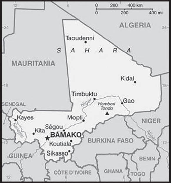
Location: interior Western Africa, southwest of Algeria, north of Guinea, Cote d’Ivoire, and Burkina Faso, west of Niger
Geographic coordinates: 17 00 N, 4 00 W
Map references: Africa
Area: total: 1,240,192 sq km
land: 1,220,190 sq km
water: 20,002 sq km
comparison ranking: total 25
Area - comparative: slightly less than twice the size of Texas
Land boundaries: total: 7,908 km
border countries (6): Algeria 1,359 km; Burkina Faso 1,325 km; Cote d’Ivoire 599 km; Guinea 1,062 km; Mauritania 2,236 km; Niger 838 km, Senegal 489 km
Coastline: 0 km (landlocked)
Maritime claims: none (landlocked)
Climate: subtropical to arid; hot and dry (February to June); rainy, humid, and mild (June to November); cool and dry (November to February)
Terrain: mostly flat to rolling northern plains covered by sand; savanna in south, rugged hills in northeast
Elevation: highest point: Hombori Tondo 1,155 m
lowest point: Senegal River 23 m
mean elevation: 343 m
Natural resources: gold, phosphates, kaolin, salt, limestone, uranium, gypsum, granite, hydropower, note, bauxite, iron ore, manganese, tin, and copper deposits are known but not exploited
Land use: agricultural land: 34.1% (2018 est.)
arable land: 5.6% (2018 est.)
permanent crops: 0.1% (2018 est.)
permanent pasture: 28.4% (2018 est.)
forest: 10.2% (2018 est.)
other: 55.7% (2018 est.)
Irrigated land: 3,780 sq km (2012)
Major lakes (area sq km): fresh water lake(s): Lac Faguibine - 590 sq km
note - the Niger River is the only source of water for the lake; in recent years the lake is dry
Major rivers (by length in km): Niger (shared with Guinea [s], Niger, and Nigeria [m]) - 4,200 km; Senegal (shared with Guinea [s], Senegal, and Mauritania [m]) - 1,641 km
note – [s] after country name indicates river source; [m] after country name indicates river mouth
Major watersheds (area sq km): Atlantic Ocean drainage: Niger (2,261,741 sq km), Senegal (456,397 sq km), Volta (410,991 sq km)
Major aquifers: Lullemeden-Irhazer Basin, Taodeni-Tanezrouft Basin
Population distribution: the overwhelming majority of the population lives in the southern half of the country, with greater density along the border with Burkina Faso as shown in this population distribution map
Natural hazards: hot, dust-laden harmattan haze common during dry seasons; recurring droughts; occasional Niger River flooding
Geography - note: landlocked; divided into three natural zones: the southern, cultivated Sudanese; the central, semiarid Sahelian; and the northern, arid Saharan
PEOPLE AND SOCIETY
Population: 21,359,722 (2023 est.)
comparison ranking: 61
Nationality: noun: Malian(s)
adjective: Malian
Ethnic groups: Bambara 33.3%, Fulani (Peuhl) 13.3%, Sarakole/Soninke/Marka 9.8%, Senufo/Manianka 9.6%, Malinke 8.8%, Dogon 8.7%, Sonrai 5.9%, Bobo 2.1%, Tuareg/Bella 1.7%, other Malian 6%, from members of Economic Community of West Africa 0.4%, other 0.3% (2018 est.)
Languages: Bambara (official), French 17.2%, Peuhl/Foulfoulbe/Fulani 9.4%, Dogon 7.2%, Maraka/Soninke 6.4%, Malinke 5.6%, Sonrhai/Djerma 5.6%, Minianka 4.3%, Tamacheq 3.5%, Senoufo 2.6%, Bobo 2.1%, other 6.3%, unspecified 0.7% (2009 est.)
note: Mali has 13 national languages in addition to its official language
Religions: Muslim 93.9%, Christian 2.8%, animist 0.7%, none 2.5% (2018 est.)
Demographic profile: Mali’s total population is expected to double by 2035; its capital Bamako is one of the fastest-growing cities in Africa. A young age structure, a declining mortality rate, and a sustained high total fertility rate of 5.5 children per woman – the fourth highest in the world, as of 2022 – ensure continued rapid population growth for the foreseeable future. Significant outmigration only marginally tempers this growth. Despite decreases, Mali’s infant, child, and maternal mortality rates remain among the highest in Sub-Saharan Africa because of limited access to and adoption of family planning, early childbearing, short birth intervals, the prevalence of female genital cutting, infrequent use of skilled birth attendants, and a lack of emergency obstetrical and neonatal care.
Mali’s high total fertility rate has been virtually unchanged for decades, as a result of the ongoing preference for large families, early childbearing, the lack of female education and empowerment, poverty, and extremely low contraceptive use. Slowing Mali’s population growth by lowering its birth rate will be essential for poverty reduction, improving food security, and developing human capital and the economy.
Mali has a long history of seasonal migration and emigration driven by poverty, conflict, demographic pressure, unemployment, food insecurity, and droughts. Many Malians from rural areas migrate during the dry period to nearby villages and towns to do odd jobs or to adjoining countries to work in agriculture or mining. Pastoralists and nomads move seasonally to southern Mali or nearby coastal states. Others migrate long term to Mali’s urban areas, Cote d’Ivoire, other neighboring countries, and in smaller numbers to France, Mali’s former colonial ruler. Since the early 1990s, Mali’s role has grown as a transit country for regional migration flows and illegal migration to Europe. Human smugglers and traffickers exploit the same regional routes used for moving contraband drugs, arms, and cigarettes.
Between early 2012 and 2013, renewed fighting in northern Mali between government forces and Tuareg secessionists and their Islamist allies, a French-led international military intervention, as well as chronic food shortages, caused the displacement of hundreds of thousands of Malians. Most of those displaced domestically sought shelter in urban areas of southern Mali, except for pastoralist and nomadic groups, who abandoned their traditional routes, gave away or sold their livestock, and dispersed into the deserts of northern Mali or crossed into neighboring countries. Almost all Malians who took refuge abroad (mostly Tuareg and Maure pastoralists) stayed in the region, largely in Mauritania, Niger, and Burkina Faso.
Age structure: 0-14 years: 47.05% (male 5,054,927/female 4,995,605)
15-64 years: 49.88% (male 5,006,470/female 5,647,289)
65 years and over: 3.07% (2023 est.) (male 323,170/female 332,261)
Dependency ratios: total dependency ratio: 99.3
youth dependency ratio: 94.5
elderly dependency ratio: 4.9
potential support ratio: 20.6 (2021 est.)
Median age: total: 16 years (2020)
male: 15.3 years
female: 16.7 years
comparison ranking: total 224
Population growth rate: 2.93% (2023 est.)
comparison ranking: 11
Birth rate: 40.54 births/1,000 population (2023 est.)
comparison ranking: 4
Death rate: 8.3 deaths/1,000 population (2023 est.)
comparison ranking: 79
Net migration rate: -2.99 migrant(s)/1,000 population (2023 est.)
comparison ranking: 181
Population distribution: the overwhelming majority of the population lives in the southern half of the country, with greater density along the border with Burkina Faso as shown in this population distribution map
Urbanization: urban population: 46.2% of total population (2023)
rate of urbanization: 4.57% annual rate of change (2020-25 est.)
Major urban areas - population: 2.929 million BAMAKO (capital) (2023)
Sex ratio: at birth: 1.03 male(s)/female
0-14 years: 1.01 male(s)/female
15-64 years: 0.89 male(s)/female
65 years and over: 0.97 male(s)/female
total population: 0.95 male(s)/female (2023 est.)
Mother’s mean age at first birth: 19.2 years (2018 est.)
note: data represents median age at first birth among women 20-49
Maternal mortality ratio: 440 deaths/100,000 live births (2020 est.)
comparison ranking: 20
Infant mortality rate: total: 58.99 deaths/1,000 live births (2023 est.)
male: 64.31 deaths/1,000 live births
female: 53.5 deaths/1,000 live births
comparison ranking: total 11
Life expectancy at birth: total population: 62.81 years (2023 est.)
male: 60.56 years
female: 65.13 years
comparison ranking: total population 211
Total fertility rate: 5.45 children born/woman (2023 est.)
comparison ranking: 4
Gross reproduction rate: 2.68 (2023 est.)
Contraceptive prevalence rate: 17.2% (2018)
Drinking water source: improved: urban: 99.9% of population
rural: 75.9% of population
total: 86.4% of population
unimproved: urban: 0.1% of population
rural: 24.1% of population
total: 13.6% of population (2020 est.)
Current health expenditure: 4.3% of GDP (2020)
Physicians density: 0.13 physicians/1,000 population (2018)
Hospital bed density: 0.1 beds/1,000 population
Sanitation facility access: improved: urban: 85.7% of population
rural: 44.7% of population
total: 62.7% of population
unimproved: urban: 14.3% of population
rural: 55.3% of population
total: 37.3% of population (2020 est.)
Major infectious diseases: degree of risk: very high (2023)
food or waterborne diseases: bacterial and protozoal diarrhea, hepatitis A, and typhoid fever
vectorborne diseases: malaria and dengue fever
water contact diseases: schistosomiasis
animal contact diseases: rabies
respiratory diseases: meningococcal meningitis
aerosolized dust or soil contact diseases: Lassa fever
note: on 31 August 2023, the US Centers for Disease Control and Prevention (CDC) issued a Travel Alert for polio in Africa; Mali is currently considered a high risk to travelers for circulating vaccine-derived polioviruses (cVDPV); vaccine-derived poliovirus (VDPV) is a strain of the weakened poliovirus that was initially included in oral polio vaccine (OPV) and that has changed over time and behaves more like the wild or naturally occurring virus; this means it can be spread more easily to people who are unvaccinated against polio and who come in contact with the stool or respiratory secretions, such as from a sneeze, of an “infected” person who received oral polio vaccine; the CDC recommends that before any international travel, anyone unvaccinated, incompletely vaccinated, or with an unknown polio vaccination status should complete the routine polio vaccine series; before travel to any high-risk destination, the CDC recommends that adults who previously completed the full, routine polio vaccine series receive a single, lifetime booster dose of polio vaccine
Obesity - adult prevalence rate: 8.6% (2016)
comparison ranking: 150
Alcohol consumption per capita: total: 0.6 liters of pure alcohol (2019 est.)
beer: 0.09 liters of pure alcohol (2019 est.)
wine: 0 liters of pure alcohol (2019 est.)
spirits: 0.02 liters of pure alcohol (2019 est.)
other alcohols: 0.49 liters of pure alcohol (2019 est.)
comparison ranking: total 159
Tobacco use: total: 8.3% (2020 est.)
male: 15.6% (2020 est.)
female: 1% (2020 est.)
comparison ranking: total 146
Children under the age of 5 years underweight: 18.5% (2022)
comparison ranking: 24
Currently married women (ages 15-49): 77.9% (2023 est.)
Child marriage: women married by age 15: 15.9%
women married by age 18: 53.7%
men married by age 18: 2.1% (2018 est.)
Education expenditures: 4.4% of GDP (2021 est.)
comparison ranking: 105
Literacy: definition: age 15 and over can read and write
total population: 35.5%
male: 46.2%
female: 25.7% (2018)
School life expectancy (primary to tertiary education): total: 7 years
male: 8 years
female: 7 years (2017)
Youth unemployment rate (ages 15-24): total: 17.3% (2021 est.)
male: 15.4%
female: 19.8%
comparison ranking: total 100
ENVIRONMENT
Environment - current issues: deforestation; soil erosion; desertification; loss of pasture land; inadequate supplies of potable water
Environment - international agreements: party to: Biodiversity, Climate Change, Climate Change-Kyoto Protocol, Climate Change-Paris Agreement, Comprehensive Nuclear Test Ban, Desertification, Endangered Species, Hazardous Wastes, Law of the Sea, Ozone Layer Protection, Tropical Timber 2006, Wetlands, Whaling
signed, but not ratified: Nuclear Test Ban
Climate: subtropical to arid; hot and dry (February to June); rainy, humid, and mild (June to November); cool and dry (November to February)
Land use: agricultural land: 34.1% (2018 est.)
arable land: 5.6% (2018 est.)
permanent crops: 0.1% (2018 est.)
permanent pasture: 28.4% (2018 est.)
forest: 10.2% (2018 est.)
other: 55.7% (2018 est.)
Urbanization: urban population: 46.2% of total population (2023)
rate of urbanization: 4.57% annual rate of change (2020-25 est.)
Food insecurity: severe localized food insecurity: due to civil insecurity and high food prices - according to the latest analysis, about 1.26 million people are projected to face acute food insecurity during the June to August 2023 lean season period; in total however, the number of food insecure is lower in 2023 compared to 2022; food insecurity conditions are primarily underpinned by the impact of the conflict in central and northern areas, which has caused the displacement of over 375,000 people, as of April 2023; persistent high food prices affect vulnerable households across the country, but limit in particular the food access of people in conflict-affected areas due to market disruptions and limited access to sources of income and humanitarian assistance
(2023)
Revenue from forest resources: 2.02% of GDP (2018 est.)
comparison ranking: 35
Revenue from coal: 0% of GDP (2018 est.)
comparison ranking: 115
Air pollutants: particulate matter emissions: 38.55 micrograms per cubic meter (2019 est.)
carbon dioxide emissions: 3.18 megatons (2016 est.)
methane emissions: 19.16 megatons (2020 est.)
Waste and recycling: municipal solid waste generated annually: 1,937,354 tons (2012 est.)
Major lakes (area sq km): fresh water lake(s): Lac Faguibine - 590 sq km
note - the Niger River is the only source of water for the lake; in recent years the lake is dry
Major rivers (by length in km): Niger (shared with Guinea [s], Niger, and Nigeria [m]) - 4,200 km; Senegal (shared with Guinea [s], Senegal, and Mauritania [m]) - 1,641 km
note – [s] after country name indicates river source; [m] after country name indicates river mouth
Major watersheds (area sq km): Atlantic Ocean drainage: Niger (2,261,741 sq km), Senegal (456,397 sq km), Volta (410,991 sq km)
Major aquifers: Lullemeden-Irhazer Basin, Taodeni-Tanezrouft Basin
Total water withdrawal: municipal: 110 million cubic meters (2020 est.)
industrial: 4 million cubic meters (2020 est.)
agricultural: 5.08 billion cubic meters (2020 est.)
Total renewable water resources: 120 billion cubic meters (2020 est.)
GOVERNMENT
Country name: conventional long form: Republic of Mali
conventional short form: Mali
local long form: Republique de Mali
local short form: Mali
former: French Sudan, Sudanese Republic, Mali Federation
etymology: name derives from the West African Mali Empire of the 13th to 16th centuries A.D.
Government type: semi-presidential republic
Capital: name: Bamako
geographic coordinates: 12 39 N, 8 00 W
time difference: UTC 0 (5 hours ahead of Washington, DC, during Standard Time)
etymology: the name in the Bambara language can mean either “crocodile tail” or “crocodile river” and three crocodiles appear on the city seal
Administrative divisions: 10 regions (regions, singular - region), 1 district*; District de Bamako*, Gao, Kayes, Kidal, Koulikoro, Menaka, Mopti, Segou, Sikasso, Taoudenni, Tombouctou (Timbuktu); note - Menaka and Taoudenni were legislated in 2016, but implementation has not been confirmed by the US Board on Geographic Names
Independence: 22 September 1960 (from France)
National holiday: Independence Day, 22 September (1960)
Constitution: history: several previous; latest drafted 13 October 2022 and submitted to Transition President Assimi GOITA; final draft completed 1 March 2023; referendum held on 18 June 2023 and approved; referendum results validated by Constitutional Court on 22 July 2023; note - the new constitution includes provisions for the extension of presidential and military powers and the creation of a “senate”
amendments: procedure for amending the 2023 constitution NA
Legal system: civil law system based on the French civil law model and influenced by customary law; judicial review of legislative acts in the Constitutional Court
International law organization participation: has not submitted an ICJ jurisdiction declaration; accepts ICCt jurisdiction
Citizenship: citizenship by birth: no
citizenship by descent only: at least one parent must be a citizen of Mali
dual citizenship recognized: yes
residency requirement for naturalization: 5 years
Suffrage: 18 years of age; universal
Executive branch: chief of state: Transition President Assimi GOITA (since 7 June 2021); note - an August 2020 coup d’état deposed President Ibrahim Boubacar KEITA; on 21 September 2020, a group of 17 electors chosen by the Malian military junta, known as the National Committee for the Salvation of the People (CNSP) and led by Colonel Assimi GOITA, selected Bah NDAW as transition president; GOITA served as vice president of the transitional government which was inaugurated on 25 September 2020; Vice President GOITA seized power on 25 May 2021; NDAW resigned on 26 May 2021; on 6 June 2022, GOITA’s government announced a transition period of 24 months with a planned return to civilian rule by March 2024
head of government: Transition Prime Minister Choguel MAIGA (appointed by Transitional President Assimi GOITA on 7 June 2021)
note: former transition Prime Minister Moctar OUANE was arrested and detained by the military on 24 May 2021 and resigned on 26 May 2021
cabinet: Council of Ministers appointed by the prime minister
elections/appointments: president directly elected by absolute majority popular vote in 2 rounds if needed for a 5-year term (eligible for a second term); election last held on 29 July 2018 with runoff on 12 August 2018; prime minister appointed by the president; note - on 21 February 2022, the transition government adopted a charter allowing transition authorities to rule for up to 5 years; thereafter, transition President GOITA is barred as a candidate in presidential elections
election results:
2018: Ibrahim Boubacar KEITA elected president in second round; percent of vote in first round - Ibrahim Boubacar KEITA (RPM) 41.7%, Soumaila CISSE (URD) 17.8%, other 40.5%; percent of vote in second round - Ibrahim Boubacar KEITA 67.2%, Soumaila CISSE 32.8%
2013: Ibrahim Boubacar KEITA elected president in second round; percent of vote in first round - Ibrahim Boubacar KEITA (RPM) 39.8%, Soumaila CISSE (URD) 19.7%, other 40.5%; percent of vote in second round - Ibrahim Boubacar KEITA (RPM) 77.6%, Soumaila CISSE (URD) 22.4%
Legislative branch: description: unicameral National Assembly or Assemblee Nationale (147 seats; members directly elected in single and multi-seat constituencies by absolute majority vote in 2 rounds if needed; 13 seats reserved for citizens living abroad; members serve 5-year terms)
note 1 - the National Assembly was dissolved on 18 August 2020 following a military coup and the resignation of President KEITA; the transition government created a National Transition Council (CNT) whose 121 members were selected by then-transition vice president Assimi GOITA; the CNT acts as the transition government’s legislative body with Malick DIAW serving as the president; in February 2022, the CNT increased the number of seats to 147 but the additional seats have not yet been filled
note 2 - passage of a constitutional referendum held on 18 June 2023 calls for the creation of a “senate”
elections: last held on 30 March and 19 April 2020
election results: percent of vote by party - NA; seats by party - NA composition - NA
Judicial branch: highest court(s): Supreme Court or Cour Supreme (consists of 19 judges organized into judicial, administrative, and accounting sections); Constitutional Court (consists of 9 judges)
judge selection and term of office: Supreme Court judges appointed by the Ministry of Justice to serve 5-year terms; Constitutional Court judges selected - 3 each by the president, the National Assembly, and the Supreme Council of the Magistracy; members serve single renewable 7-year terms
subordinate courts: Court of Appeal; High Court of Justice (jurisdiction limited to cases of high treason or criminal offenses by the president or ministers while in office); administrative courts (first instance and appeal); commercial courts; magistrate courts; labor courts; juvenile courts; special court of state security
Political parties and leaders: African Solidarity for Democracy and Independence or SADI [Oumar MARIKO]
Alliance for Democracy and Progress or ADP-Maliba [Amadou THIAM]
Alliance for Democracy in Mali-Pan-African Party for Liberty, Solidarity, and Justice or ADEMA-PASJ [Tiemoko SANGARE]
Alliance for the Solidarity of Mali-Convergence of Patriotic Forces or ASMA-CFP [Amadou CISSE, vice-president, acting]
Convergence for the Development of Mali or CODEM [Housseyni Amion GUINDO]
Democratic Alliance for Peace or ADP-Maliba [Aliou Boubacar DIALLO]
Movement for Mali or MPM [Brahima DIANESSY, deputy]
Party for National Renewal (also Rebirth or Renaissance or PARENA) [Tiebile DRAME]
Rally for Mali or RPM [Boucary TRETA]
Social Democratic Convention or CDS [Mamadou Bakary “Blaise” SANGARE]
Union for Democracy and Development or UDD [Hassane BARRY]
Union for Republic and Democracy or URD [Soumaïla CISSE]
Yéléma [Moussa MARA]
note 1: only parties with 2 or more seats in the last National Assembly parliamentary elections (30 March and 19 April 2020) listed
note 2: the National Assembly was dissolved on 18 August 2020 following a military coup and replaced with a National Transition Council; currently 121 members, party affiliations unknown
International organization participation: ACP, AfDB, AU (suspended), CD, ECOWAS (suspended), EITI (compliant country), FAO, FZ, G-77, IAEA, IBRD, ICAO, ICCt, ICRM, IDA, IDB, IFAD, IFC, IFRCS, ILO, IMF, Interpol, IOC, IOM, IPU, ISO, ITSO, ITU, ITUC (NGOs), MIGA, MINUSCA, MONUSCO, NAM, OIC, OIF, OPCW, UN, UNCTAD, UNDP, UNESCO, UNFPA, UNHCR, UNIDO, UNOPS, UN Women, UNWTO, UPU, WADB (regional), WAEMU, World Bank Group, WCO, WFTU (NGOs), WHO, WIPO, WMO, WTO
Diplomatic representation in the US: chief of mission: Ambassador Sékou BERTHE (since 16 September 2022)
chancery: 2130 R Street NW, Washington, DC 20008
telephone: [1] (202) 332-2249
FAX: [1] (202) 332-6603
email address and website:
Diplomatic representation from the US: chief of mission: Ambassador Rachna KORHONEN (since 16 March 2023)
embassy: ACI 2000, Rue 243, (located off the Roi Bin Fahad Aziz Bridge west of the Bamako central district), Porte 297, Bamako
mailing address: 2050 Bamako Place, Washington DC 20521-2050
telephone: [223] 20-70-23-00
FAX: [223] 20-70-24-79
email address and website:
Flag description: three equal vertical bands of green (hoist side), yellow, and red
note: uses the popular Pan-African colors of Ethiopia; the colors from left to right are the same as those of neighboring Senegal (which has an additional green central star) and the reverse of those on the flag of neighboring Guinea
National symbol(s): Great Mosque of Djenne; national colors: green, yellow, red
National anthem: name: “Le Mali” (Mali)
lyrics/music: Seydou Badian KOUYATE/Banzoumana SISSOKO
note: adopted 1962; also known as “Pour L’Afrique et pour toi, Mali” (For Africa and for You, Mali) and “A ton appel Mali” (At Your Call, Mali)
National heritage: total World Heritage Sites: 4 (3 cultural, 1 mixed)
selected World Heritage Site locales: Old Towns of Djenné (c); Timbuktu (c); Cliff of Bandiagara (Land of the Dogons) (m); Tomb of Askia (c)
ECONOMY
Economic overview: low-income Saharan economy; recession due to COVID-19 and political instability; extreme poverty; environmentally fragile; high public debt; agricultural and gold exporter; terrorism and warfare are common
Real GDP (purchasing power parity): $46.452 billion (2021 est.)
$45.076 billion (2020 est.)
$45.64 billion (2019 est.)
note: data are in 2017 dollars
comparison ranking: 116
Real GDP growth rate: 3.05% (2021 est.)
-1.24% (2020 est.)
4.76% (2019 est.)
comparison ranking: 143
Real GDP per capita: $2,100 (2021 est.)
$2,100 (2020 est.)
$2,200 (2019 est.)
note: data are in 2017 dollars
comparison ranking: 212
GDP (official exchange rate): $17.508 billion (2019 est.)
Inflation rate (consumer prices): 3.93% (2021 est.)
0.44% (2020 est.)
-1.66% (2019 est.)
comparison ranking: 98
Credit ratings: Moody’s rating: Caa1 (2020)
note: The year refers to the year in which the current credit rating was first obtained.
GDP - composition, by sector of origin: agriculture: 41.8% (2017 est.)
industry: 18.1% (2017 est.)
services: 40.5% (2017 est.)
comparison rankings: services 209; industry 162; agriculture 7
GDP - composition, by end use: household consumption: 82.9% (2017 est.)
government consumption: 17.4% (2017 est.)
investment in fixed capital: 19.3% (2017 est.)
investment in inventories: -0.7% (2017 est.)
exports of goods and services: 22.1% (2017 est.)
imports of goods and services: -41.1% (2017 est.)
Agricultural products: maize, rice, millet, sorghum, mangoes/guavas, cotton, watermelons, green onions/shallots, okra, sugar cane
Industries: food processing; construction; phosphate and gold mining
Industrial production growth rate: 1.01% (2021 est.)
comparison ranking: 149
Labor force: 7.9 million (2021 est.)
comparison ranking: 68
Labor force - by occupation: agriculture: 80%
industry and services: 20% (2005 est.)
Unemployment rate: 7.72% (2021 est.)
7.7% (2020 est.)
7.44% (2019 est.)
comparison ranking: 99
Youth unemployment rate (ages 15-24): total: 17.3% (2021 est.)
male: 15.4%
female: 19.8%
comparison ranking: total 100
Population below poverty line: 42.1% (2019 est.)
Gini Index coefficient - distribution of family income: 36.1 (2018 est.)
comparison ranking: 87
Household income or consumption by percentage share: lowest 10%: 3.5%
highest 10%: 25.8% (2010 est.)
Budget: revenues: $2.657 billion (2018 est.)
expenditures: $3.467 billion (2018 est.)
Budget surplus (+) or deficit (-): -2.9% (of GDP) (2017 est.)
comparison ranking: 126
Public debt: 35.4% of GDP (2017 est.)
36% of GDP (2016 est.)
comparison ranking: 152
Taxes and other revenues: 14.16% (of GDP) (2020 est.)
comparison ranking: 160
Fiscal year: calendar year
Current account balance: -$379.683 million (2020 est.)
-$1.289 billion (2019 est.)
-$836.255 million (2018 est.)
comparison ranking: 113
Exports: $5.196 billion (2020 est.) note: data are in current year dollars
$4.442 billion (2019 est.)
$4.186 billion (2018 est.)
comparison ranking: 128
Exports - partners: United Arab Emirates 66%, Switzerland 26% (2019)
Exports - commodities: gold, cotton, sesame seeds, lumber, refined petroleum (2021)
Imports: $6.339 billion (2020 est.) note: data are in current year dollars
$6.559 billion (2019 est.)
$6.081 billion (2018 est.)
comparison ranking: 131
Imports - partners: Senegal 23%, Cote d’Ivoire 15%, China 11%, France 9% (2019)
Imports - commodities: refined petroleum, clothing and apparel, packaged medicines, cement, broadcasting equipment (2019)
Reserves of foreign exchange and gold: $647.8 million (31 December 2017 est.)
$395.7 million (31 December 2016 est.)
comparison ranking: 163
Debt - external: $4.192 billion (31 December 2017 est.)
$3.981 billion (31 December 2016 est.)
comparison ranking: 138
Exchange rates: Communaute Financiere Africaine francs (XOF) per US dollar -
Exchange rates: 554.531 (2021 est.)
575.586 (2020 est.)
585.911 (2019 est.)
555.446 (2018 est.)
580.657 (2017 est.)
ENERGY
Electricity access: population without electricity: 10 million (2020)
electrification - total population: 53.3% (2021)
electrification - urban areas: 96.8% (2021)
electrification - rural areas: 18.2% (2021)
Electricity: installed generating capacity: 890,000 kW (2020 est.)
consumption: 2,620,980,000 kWh (2019 est.)
exports: 550 million kWh (2019 est.)
imports: 200 million kWh (2019 est.)
transmission/distribution losses: 346 million kWh (2019 est.)
comparison rankings: installed generating capacity 137; transmission/distribution losses 138; imports 102; exports 73; consumption 144
Electricity generation sources: fossil fuels: 67.4% of total installed capacity (2020 est.)
solar: 1% of total installed capacity (2020 est.)
hydroelectricity: 29.7% of total installed capacity (2020 est.)
biomass and waste: 1.9% of total installed capacity (2020 est.)
Petroleum: total petroleum production: 0 bbl/day (2021 est.)
refined petroleum consumption: 37,600 bbl/day (2019 est.)
Refined petroleum products - imports: 20,610 bbl/day (2015 est.)
comparison ranking: 119
Carbon dioxide emissions: 5.679 million metric tonnes of CO2 (2019 est.)
from petroleum and other liquids: 5.679 million metric tonnes of CO2 (2019 est.)
comparison ranking: total emissions 134
Energy consumption per capita: 4.396 million Btu/person (2019 est.)
comparison ranking: 172
COMMUNICATIONS
Telephones - fixed lines: total subscriptions: 301,055 (2021 est.)
subscriptions per 100 inhabitants: 1 (2021 est.)
comparison ranking: total subscriptions 109
Telephones - mobile cellular: total subscriptions: 21,882,251 (2021 est.)
subscriptions per 100 inhabitants: 100 (2021 est.)
comparison ranking: total subscriptions 59
Telecommunication systems: general assessment: Mali’s telecom systems are challenged by recent conflict, geography, areas of low population, poverty, security issues, and high illiteracy; telecom infrastructure is barely adequate in urban areas and not available in most of the country with underinvestment in fixed-line networks; high mobile penetration and potential for mobile broadband service; local plans for IXP; dependent on neighboring countries for international bandwidth and access to submarine cables (2022)
domestic: fixed-line subscribership is 1 per 100 persons; mobile-cellular subscribership has increased sharply to 100 per 100 persons (2021)
international: country code - 223; satellite communications center and fiber-optic links to neighboring countries; satellite earth stations - 2 Intelsat (1 Atlantic Ocean, 1 Indian Ocean) (2020)
Broadcast media: national public TV broadcaster; 2 privately owned companies provide subscription services to foreign multi-channel TV packages; national public radio broadcaster supplemented by a large number of privately owned and community broadcast stations; transmissions of multiple international broadcasters are available (2019)
Internet country code: .ml
Internet users: total: 7.48 million (2021 est.)
percent of population: 34% (2021 est.)
comparison ranking: total 78
Broadband - fixed subscriptions: total: 243,806 (2020 est.)
subscriptions per 100 inhabitants: 1 (2020 est.)
comparison ranking: total 112
TRANSPORTATION
National air transport system: number of registered air carriers: 0 (2020)
Civil aircraft registration country code prefix: TZ, TT
Airports: 25 (2021)
comparison ranking: total 127
Airports - with paved runways: 8
note: paved runways have a concrete or asphalt surface but not all have facilities for refueling, maintenance, or air traffic control; the length of a runway required for aircraft to safely operate depends on a number of factors including the type of aircraft, the takeoff weight (including passengers, cargo, and fuel), engine types, flap settings, landing speed, elevation of the airport, and average maximum daily air temperature; paved runways can reach a length of 5,000 m (16,000 ft.), but the “typical” length of a commercial airline runway is between 2,500-4,000 m (8,000-13,000 ft.)
Airports - with unpaved runways: 17
note: unpaved runways have a surface composition such as grass or packed earth and are most suited to the operation of light aircraft; unpaved runways are usually short, often less than 1,000 m (3,280 ft.) in length; airports with unpaved runways often lack facilities for refueling, maintenance, or air traffic control
Heliports: 2 (2021)
Railways: total: 593 km (2014)
narrow gauge: 593 km (2014) 1.000-m gauge
comparison ranking: total 109
Roadways: total: 139,107 km (2018)
paved: (2009)
unpaved: (2009)
comparison ranking: total 38
Waterways: 1,800 km (2011) (downstream of Koulikoro; low water levels on the River Niger cause problems in dry years; in the months before the rainy season the river is not navigable by commercial vessels)
comparison ranking: 45
Ports and terminals: river port(s): Koulikoro (Niger)
MILITARY AND SECURITY
Military and security forces: Malian Armed Forces (Forces Armées Maliennes or FAMa): Land Forces (l’Armée de Terre), Air Force (l’Armée de l’Air); National Guard (la Garde Nationale du Mali or GNM); General Directorate of the National Gendarmerie (la Direction Générale de la Gendarmerie Nationale or DGGN) (2023)
note 1: the Gendarmerie and the National Guard are under the authority of the Ministry of Defense and Veterans Affairs (Ministere De La Defense Et Des Anciens Combattants, MDAC), but operational control is shared with the Ministry of Internal Security and Civil Protection which also controls the National Police; the National Police has responsibility for law enforcement and maintenance of order in urban areas and supports the FAMa in internal military operations
note 2: the Gendarmerie’s primary mission is internal security and public order; its duties also include territorial defense, humanitarian operations, intelligence gathering, and protecting private property, mainly in rural areas; it also has a specialized border security unit
note 3: the National Guard is a military force responsible for providing security to government facilities and institutions, prison service, public order, humanitarian operations, some border security, and intelligence gathering; its forces include a camel corps for patrolling the deserts and borders of northern Mali
note 4: there are also pro-government militias operating in Mali, such as the Imghad Tuareg Self-Defense Group and Allies (GATIA); the leader of GATIA is also a general in the national army
Military expenditures: 3.5% of GDP (2022 est.)
3.5% of GDP (2021 est.)
3.4% of GDP (2020 est.)
3.1% of GDP (2019 est.)
3.1% of GDP (2018 est.)
comparison ranking: 22
Military and security service personnel strengths: information varies; estimated 35,000 total active military and paramilitary personal, including approximately 20,000 FAMa (up to 2,000 Air Force), 5,000 Gendarmerie, and 10,000 National Guard (2023)
Military equipment inventories and acquisitions: the FAMa’s inventory consists primarily of Soviet-era equipment, although in recent years it has received limited quantities of newer armaments from more than a dozen countries, especially China and Russia (2023)
Military service age and obligation: 18 years of age for men and women for selective compulsory and voluntary military service; 24-month compulsory service obligation (2023)
Military deployments: note: until announcing its withdrawal in May of 2022, Mali was part of a five-nation anti-jihadist task force known as the G5 Sahel Group, set up in 2014 with Burkina Faso, Chad, Mauritania, and Niger; Mali had committed 1,100 troops and 200 gendarmes to the force
Military - note: the FAMa is responsible for defense of the country’s sovereignty and territory, but also has some domestic security duties, including the maintenance of public order and support to law enforcement if required, as well as counterterrorism and counterinsurgency operations; it also participates in socio-economic development projects; the military has traditionally played a large role in Mali’s politics; prior to the coup in August 2020 and military takeover in May 2021, it had intervened in the political arena at least five times since the country gained independence in 1960; two attempts failed (1976 and 1978), while three succeeded in overturning civilian rule (1968, 1991, and 2012)
the FAMa and other security forces are actively engaged in operations against several insurgent/terrorist groups affiliated with al-Qa’ida and the Islamic State of Iraq and ash-Sham (ISIS), as well as other rebel groups, communal militias, and criminal bands spread across the central, northern, and southern regions of the country; the government is reportedly in control of only an estimated 10-20% of the country’s central and northern territories, and attacks are increasing in the more heavily populated south, including around the capital Bamako; the Macina Liberation Front (FLM), part of the Jama’at Nusrat al Islam wal Muslimin (JNIM) coalition of al-Qa’ida-linked terror groups, has played a large role in a surge in violence in Mali’s central and southern regions; in the north, ISIS in the Greater Sahara (ISIS-GS) has regained strength in recent years
the FAMa and the remainder of the security forces collapsed in 2012 during the fighting against Tuareg rebels and Islamic militants and have since been rebuilt with considerable external assistance, including the EU, France, and the UN; for example, the EU Training Mission in Mali (EUTM) from 2013-2022 trained as many as 15,000 Malian soldiers and 8 combined arms battalions/battlegroups (Groupement Tactique InterArmes, GTIA), each of which was structured to be self-sufficient with its own motorized/mechanized infantry, light armor, commandos, artillery, engineers, and other support forces; EUTM suspended its training program in 2022, citing issues with the ruling military government, including human rights abuses and the presence of Russian private military contractors; over the same period, the French military provided considerable assistance to the Malian security forces and conducted counterterrorism and counterinsurgency operations in Mali; the French suspended operations in 2021 and in August 2022 withdrew the last of its forces while also citing issues with the military government; the UN Multidimensional Integrated Stabilization Mission in Mali (MINUSMA) has operated in the country since 2013 with the mission of providing security, rebuilding Malian security forces, protecting civilians, supporting national political dialogue, and assisting in the reestablishment of Malian government authority; as of 2023, MINUSMA had around 15,000 personnel assigned; however, in June 2023, the UN Security Council voted to end the MINUSMA mission after the ruling junta demanded the withdrawal of foreign forces and aligned itself closer to Russia; MINUSMA personnel are slated to remain in Mali until the end of 2023
in addition to the EU-trained GTIAs, the Army has commandos and special forces, as well as recently created motorcycle-mounted reconnaissance units; the Air Force has small numbers of combat aircraft and helicopters, as well as a few armed UAVs; the Gendarmerie and National Guard field company-sized paramilitary units, including camelmounted forces in the National Guard; they also have special anti-terrorism and intervention forces
the military government has increased security ties with Russia; Russia has provided military equipment, and in December 2021, Mali contracted with a Russian private military company to provide training for local armed forces and security to senior Malian officials; the contractors have also participated in security operations and been accused of war crimes; as of 2022, there were an estimated 1,000 Russian military contractors in Mali (2023)
TERRORISM
Terrorist group(s): Terrorist group(s): Ansar al-Dine; Islamic State of Iraq and ash-Sham in the Greater Sahara (ISIS-GS); Jama’at Nusrat al-Islam wal-Muslimin (JNIM); al-Mulathamun Battalion (al-Mourabitoun)
note: details about the history, aims, leadership, organization, areas of operation, tactics, targets, weapons, size, and sources of support of the group(s) appear(s) in Appendix-T
TRANSNATIONAL ISSUES
Disputes - international: Mali-Burkina Faso: demarcation is underway with Burkina Faso
Refugees and internally displaced persons: refugees (country of origin): 29,138 (Burkina Faso) (refugees and asylum seekers), 20,617 (Niger) (refugees and asylum seekers), 14,956 (Mauritania) (refugees and asylum seekers) (2023)
IDPs: 375,539 (Tuareg rebellion since 2012) (2023)
Illicit drugs: a transit point for illicit drugs trafficked to Europe; trafficking controlled by armed groups, criminal organizations, terrorist groups and government officials that facilitate, protect and profit from the activity
MALTA
INTRODUCTION
Background: With a civilization that dates back thousands of years, Malta boasts some of the oldest megalithic sites in the world. Situated in the center of the Mediterranean, Malta’s islands have long served as a strategic military asset, with the islands at various times having come under control of the Phoenicians, Carthaginians, Greeks, Romans, Byzantines, Moors, Normans, Sicilians, Spanish, Knights of St. John, and the French. Most recently a British colony (since 1814), Malta gained its independence in 1964 and declared itself a republic 10 years later. While under British rule, the island staunchly supported the UK through both world wars. Since about the mid-1980s, the island has transformed itself into a freight transshipment point, a financial center, and a tourist destination while its key industries moved toward more service-oriented activities. Malta became an EU member in May 2004 and began using the euro as currency in 2008.
GEOGRAPHY
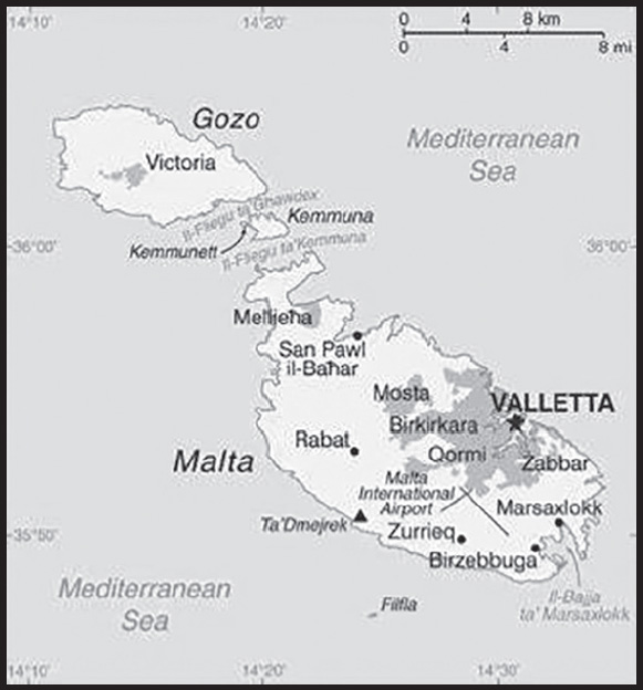
Location: Southern Europe, islands in the Mediterranean Sea, south of Sicily (Italy)
Geographic coordinates: 35 50 N, 14 35 E
Map references: Europe
Area: total: 316 sq km
land: 316 sq km
water: 0 sq km
comparison ranking: total 208
Area - comparative: slightly less than twice the size of Washington, DC
Land boundaries: total: 0 km
Coastline: 196.8 km (excludes 56 km for the island of Gozo)
Maritime claims: territorial sea: 12 nm
contiguous zone: 24 nm
continental shelf: 200-m depth or to the depth of exploitation
exclusive fishing zone: 25 nm
Climate: Mediterranean; mild, rainy winters; hot, dry summers
Terrain: mostly low, rocky, flat to dissected plains; many coastal cliffs
Elevation: highest point: Ta’Dmejrek on Dingli Cliffs 253 m
lowest point: Mediterranean Sea 0 m
Natural resources: limestone, salt, arable land
Land use: agricultural land: 32.3% (2018 est.)
arable land: 28.4% (2018 est.)
permanent crops: 3.9% (2018 est.)
permanent pasture: 0% (2018 est.)
forest: 0.9% (2018 est.)
other: 66.8% (2018 est.)
Irrigated land: 35 sq km (2020)
Population distribution: most of the population lives on the eastern half of Malta, the largest of the three inhabited islands
Natural hazards: occasional droughts
Geography - note: the country comprises an archipelago, with only the three largest islands (Malta, Ghawdex or Gozo, and Kemmuna or Comino) inhabited; numerous bays provide good harbors; Malta and Tunisia are discussing oil exploration on the continental shelf between their countries, although no commercially viable reserves have been found as of 2017
PEOPLE AND SOCIETY
Population: 467,138 (2023 est.)
comparison ranking: 174
Nationality: noun: Maltese (singular and plural)
adjective: Maltese
Ethnic groups: Maltese (descendants of ancient Carthaginians and Phoenicians with strong elements of Italian and other Mediterranean stock)
Languages: Maltese (official) 90.1%, English (official) 6%, multilingual 3%, other 0.9% (2005 est.)
Religions: Roman Catholic (official) more than 90% (2006 est.)
Age structure: 0-14 years: 14.53% (male 34,870/female 32,989)
15-64 years: 62.83% (male 151,927/female 141,561)
65 years and over: 22.65% (2023 est.) (male 48,830/female 56,961)
Dependency ratios: total dependency ratio: 47.1
youth dependency ratio: 19.3
elderly dependency ratio: 27.7
potential support ratio: 3.6 (2021 est.)
Median age: total: 42.3 years (2020)
male: 41.2 years
female: 43.5 years
comparison ranking: total 35
Population growth rate: 0.59% (2023 est.)
comparison ranking: 147
Birth rate: 9.59 births/1,000 population (2023 est.)
comparison ranking: 192
Death rate: 8.61 deaths/1,000 population (2023 est.)
comparison ranking: 71
Net migration rate: 4.96 migrant(s)/1,000 population (2023 est.)
comparison ranking: 20
Population distribution: most of the population lives on the eastern half of Malta, the largest of the three inhabited islands
Urbanization: urban population: 94.9% of total population (2023)
rate of urbanization: 0.28% annual rate of change (2020-25 est.)
Major urban areas - population: 213,000 VALLETTA (capital) (2018)
Sex ratio: at birth: 1.04 male(s)/female
0-14 years: 1.06 male(s)/female
15-64 years: 1.07 male(s)/female
65 years and over: 0.86 male(s)/female
total population: 1.02 male(s)/female (2023 est.)
Mother’s mean age at first birth: 29.3 years (2020 est.)
note: data refers to the average of the different childbearing ages of first-order births
Maternal mortality ratio: 3 deaths/100,000 live births (2020 est.)
comparison ranking: 181
Infant mortality rate: total: 4.45 deaths/1,000 live births (2023 est.)
male: 4.36 deaths/1,000 live births
female: 4.54 deaths/1,000 live births
comparison ranking: total 182
Life expectancy at birth: total population: 83.39 years (2023 est.)
male: 81.31 years
female: 85.56 years
comparison ranking: total population 13
Total fertility rate: 1.51 children born/woman (2023 est.)
comparison ranking: 201
Gross reproduction rate: 0.74 (2023 est.)
Drinking water source: improved:
total: 100% of population
unimproved:
total: 0% of population (2020 est.)
Current health expenditure: 10.8% of GDP (2020)
Physicians density: 2.86 physicians/1,000 population (2015)
Hospital bed density: 4.5 beds/1,000 population (2017)
Sanitation facility access: improved:
total: 100% of population
unimproved: total: 0% of population (2020 est.)
Obesity - adult prevalence rate: 28.9% (2016)
comparison ranking: 29
Alcohol consumption per capita: total: 8.07 liters of pure alcohol (2019 est.)
beer: 2.8 liters of pure alcohol (2019 est.)
wine: 2.34 liters of pure alcohol (2019 est.)
spirits: 2.51 liters of pure alcohol (2019 est.)
other alcohols: 0.42 liters of pure alcohol (2019 est.)
comparison ranking: total 43
Tobacco use: total: 24% (2020 est.)
male: 26.4% (2020 est.)
female: 21.6% (2020 est.)
comparison ranking: total 56
Currently married women (ages 15-49): 63.2% (2023 est.)
Education expenditures: 5.9% of GDP (2020 est.)
comparison ranking: 45
Literacy: definition: age 15 and over can read and write
total population: 94.9%
male: 93.4%
female: 96.4% (2021)
School life expectancy (primary to tertiary education): total: 17 years
male: 17 years
female: 18 years (2020)
Youth unemployment rate (ages 15-24): total: 9.8% (2021 est.)
male: 13.6%
female: 5.8%
comparison ranking: total 155
ENVIRONMENT
Environment - current issues: limited natural freshwater resources; increasing reliance on desalination; deforestation; wildlife preservation
Environment - international agreements: party to: Air Pollution, Biodiversity, Climate Change, Climate Change-Kyoto Protocol, Climate Change-Paris Agreement, Comprehensive Nuclear Test Ban, Desertification, Endangered Species, Hazardous Wastes, Law of the Sea, Marine Dumping-London Convention, Nuclear Test Ban, Ozone Layer Protection, Ship Pollution, Tropical Timber 2006, Wetlands
signed, but not ratified: none of the selected agreements
Climate: Mediterranean; mild, rainy winters; hot, dry summers
Land use: agricultural land: 32.3% (2018 est.)
arable land: 28.4% (2018 est.)
permanent crops: 3.9% (2018 est.)
permanent pasture: 0% (2018 est.)
forest: 0.9% (2018 est.)
other: 66.8% (2018 est.)
Urbanization: urban population: 94.9% of total population (2023)
rate of urbanization: 0.28% annual rate of change (2020-25 est.)
Air pollutants: particulate matter emissions: 12.93 micrograms per cubic meter (2019 est.)
carbon dioxide emissions: 1.34 megatons (2016 est.)
methane emissions: 0.2 megatons (2020 est.)
Waste and recycling: municipal solid waste generated annually: 269,000 tons (2015 est.)
municipal solid waste recycled annually: 17,996 tons (2015 est.)
percent of municipal solid waste recycled: 6.7% (2015 est.)
Total water withdrawal: municipal: 40 million cubic meters (2020 est.)
industrial: 1 million cubic meters (2020 est.)
agricultural: 20 million cubic meters (2020 est.)
Total renewable water resources: 50 million cubic meters (2020 est.)
GOVERNMENT
Country name: conventional long form: Republic of Malta
conventional short form: Malta
local long form: Repubblika ta’ Malta
local short form: Malta
etymology: the ancient Greeks called the island “Melite” meaning “honey-sweet” from the Greek word “meli” meaning “honey” and referring to the island’s honey production
Government type: parliamentary republic
Capital: name: Valletta
geographic coordinates: 35 53 N, 14 30 E
time difference: UTC+1 (6 hours ahead of Washington, DC, during Standard Time)
daylight saving time: +1hr, begins last Sunday in March; ends last Sunday in October
etymology: named in honor of Jean de VALETTE, the Grand Master of the Order of Saint John (crusader knights), who successfully led a defense of the island from an Ottoman invasion in 1565
Administrative divisions: 68 localities (Il-lokalita); Attard, Balzan, Birgu, Birkirkara, Birzebbuga, Bormla, Dingli, Fgura, Floriana, Fontana, Ghajnsielem, Gharb, Gharghur, Ghasri, Ghaxaq, Gudja, Gzira, Hamrun, Iklin, Imdina, Imgarr, Imqabba, Imsida, Imtarfa, Isla, Kalkara, Kercem, Kirkop, Lija, Luqa, Marsa, Marsaskala, Marsaxlokk, Mellieha, Mosta, Munxar, Nadur, Naxxar, Paola, Pembroke, Pieta, Qala, Qormi, Qrendi, Rabat, Rabat (Ghawdex), Safi, San Giljan/Saint Julian, San Gwann/Saint John, San Lawrenz/Saint Lawrence, Sannat, San Pawl il-Bahar/Saint Paul’s Bay, Santa Lucija/Saint Lucia, Santa Venera/Saint Venera, Siggiewi, Sliema, Swieqi, Tarxien, Ta’ Xbiex, Valletta, Xaghra, Xewkija, Xghajra, Zabbar, Zebbug, Zebbug (Ghawdex), Zejtun, Zurrieq
Independence: 21 September 1964 (from the UK)
National holiday: Independence Day, 21 September (1964); Republic Day, 13 December (1974)
Constitution: history: many previous; latest adopted 21 September 1964
amendments: proposals (Acts of Parliament) require at least two-thirds majority vote by the House of Representatives; passage of Acts requires majority vote by referendum, followed by final majority vote by the House and assent of the president of the republic; amended many times, last in 2020
Legal system: mixed legal system of English common law and civil law based on the Roman and Napoleonic civil codes; subject to European Union law
International law organization participation: accepts compulsory ICJ jurisdiction with reservations; accepts ICCt jurisdiction
Citizenship: citizenship by birth: no
citizenship by descent only: at least one parent must be a citizen of Malta
dual citizenship recognized: no
residency requirement for naturalization: 5 years
Suffrage: 18 years of age (16 in local council elections); universal
Executive branch: chief of state: President George VELLA (since 4 April 2019)
head of government: Prime Minister Robert ABELA (13 January 2020)
cabinet: Cabinet appointed by the president on the advice of the prime minister
elections/appointments: president indirectly elected by the House of Representatives for a single 5-year term; election last held on 2 April 2019 (next to be held by April 2024); following legislative elections, the leader of the majority party or majority coalition usually appointed prime minister by the president for a 5-year term; deputy prime minister appointed by the president on the advice of the prime minister
election results:
2019: George VELLA (PL) elected president; House of Representatives vote - unanimous; 2020: Robert ABELA (PL) appointed prime minister
2014: Maria Louise Coleiro PRECO elected president; House of Representatives vote - unanimous
Legislative branch: description: unicameral House of Representatives or Il-Kamra Tad-Deputati, a component of the Parliament of Malta (65 seats statutory, 79 for 2022-2027 term; members directly elected in 5 multi-seat constituencies by proportional representation vote; members serve 5-year terms)
elections: last held on 26 March 2022 (next to be held in 2027)
election results: percent of vote by party - PL 55.1%, PN 41.7%, other 3.2%; seats by party - PL 38, PN 29; composition - men 57, women 22, percent of women 27.8%; note - due to underrepresentation by women in the combined general on 26 March and two casual elections on 7 and 12 April (10 seats or 14.9%), an additional 12 seats were awarded because their percentage did not meet the 40% threshold required by the Malta Constitution or the General Elections Amendment Act 2021
Judicial branch: highest court(s): Court of Appeal (consists of either 1 or 3 judges); Constitutional Court (consists of 3 judges); Court of Criminal Appeal (consists of either 1 or 3 judges)
judge selection and term of office: Court of Appeal and Constitutional Court judges appointed by the president, usually upon the advice of the prime minister; judges of both courts serve until age 65
subordinate courts: Civil Court (divided into the General Jurisdiction Section, Family Section, and Voluntary Section); Criminal Court; Court of Magistrates; Gozo Courts (for the islands of Gozo and Comino)
Political parties and leaders: AD+PD or ADPD [Carmel CACOPARDO] (formed from the merger of Democratic Alternative or AD and Democratic Party (Partit Demokratiku) or PD)
Labor Party (Partit Laburista) or PL [Robert ABELA]
Nationalist Party (Partit Nazzjonalista) or PN [Bernard GRECH]
International organization participation: Australia Group, C, CD, CE, EAPC, EBRD, ECB, EIB, EMU, EU, FAO, IAEA, IBRD, ICAO, ICC (NGOs), ICCt, ICRM, IDA, IFAD, IFC, IFRCS, ILO, IMF, IMO, IMSO, Interpol, IOC, IOM, IPU, ISO, ITSO, ITU, ITUC (NGOs), MIGA, NATO (partner), NSG, OAS (observer), OPCW, OSCE, PCA, PFP, Schengen Convention, UN, UNCTAD, UNESCO, UNIDO, Union Latina (observer), UNWTO, UPU, Wassenaar Arrangement, WCO, WHO, WIPO, WMO, WTO
Diplomatic representation in the US: chief of mission: Ambassador Godfrey C. XUEREB (since 19 April 2023)
chancery: 2017 Connecticut Avenue NW, Washington, DC 20008; note - The Embassy of Malta has relocated until further notice to the following address due to ongoing refurbishment:
C/O WeWork Flr 2
1333 New Hampshire Ave NW
Washington DC, 20036
telephone: [1] (202) 462-3611; note - The Embassy of Malta has relocated until further notice due to ongoing refurbishment and can be reached at the following number: [1] (202) 286-4610
FAX: [1] (202) 387-5470; note - The Embassy of Malta has relocated until further notice due to ongoing refurbishment and can be reached by FAX at the following number: [1] (202) 530-9753
email address and website:
maltaembassy.washington@gov.mt
https://foreignandeu.gov.mt/en/Embassies/ME_United_States/Pages/ME_United_States.aspx
Diplomatic representation from the US: chief of mission: Ambassador Constance J. MILSTEIN (since October 27, 2022)
embassy: Ta’ Qali National Park, Attard, ATD 4000
mailing address: 5800 Valletta Place, Washington DC 20521-5800
telephone: [356] 2561-4000
email address and website:
Flag description: two equal vertical bands of white (hoist side) and red; in the upper hoist-side corner is a representation of the George Cross, edged in red; according to legend, the colors are taken from the red and white checkered banner of Count Roger of Sicily who removed a bi-colored corner and granted it to Malta in 1091; an uncontested explanation is that the colors are those of the Knights of Saint John who ruled Malta from 1530 to 1798; in 1942, King George VI of the UK awarded the George Cross to the islanders for their exceptional bravery and gallantry in World War II; since independence in 1964, the George Cross bordered in red has appeared directly on the white field
National symbol(s): Maltese eight-pointed cross; national colors: red, white
National anthem: name: “L-Innu Malti” (The Maltese Anthem)
lyrics/music: Dun Karm PSAILA/Robert SAMMUT
note: adopted 1945; written in the form of a prayer
National heritage: total World Heritage Sites: 3 (all cultural)
selected World Heritage Site locales: City of Valletta; Hal Saflieni Hypogeum; Megalithic Temples of Malta
ECONOMY
Economic overview: high-income, EU-member European economy; diversified portfolio; euro user; dependent on food and energy imports; strong tourism, trade, and manufacturing sectors; high North African immigration; large welfare system; educated workforce
Real GDP (purchasing power parity): $23.157 billion (2021 est.)
$20.995 billion (2020 est.)
$22.902 billion (2019 est.)
note: data are in 2017 dollars
comparison ranking: 149
Real GDP growth rate: 10.3% (2021 est.)
-8.32% (2020 est.)
5.92% (2019 est.)
comparison ranking: 29
Real GDP per capita: $44,700 (2021 est.)
$40,700 (2020 est.)
$45,400 (2019 est.)
note: data are in 2017 dollars
comparison ranking: 38
GDP (official exchange rate): $14.986 billion (2019 est.)
Inflation rate (consumer prices): 1.5% (2021 est.)
0.64% (2020 est.)
1.64% (2019 est.)
comparison ranking: 178
Credit ratings: Fitch rating: A+ (2017)
Moody’s rating: A2 (2019)
Standard & Poors rating: A- (2016)
note: The year refers to the year in which the current credit rating was first obtained.
GDP - composition, by sector of origin: agriculture: 1.1% (2017 est.)
industry: 10.2% (2017 est.)
services: 88.7% (2017 est.)
comparison rankings: services 11; industry 204; agriculture 195
GDP - composition, by end use: household consumption: 45.2% (2017 est.)
government consumption: 15.3% (2017 est.)
investment in fixed capital: 21.1% (2017 est.)
investment in inventories: 0.3% (2017 est.)
exports of goods and services: 136.1% (2017 est.)
imports of goods and services: -117.9% (2017 est.)
Agricultural products: milk, tomatoes, potatoes, onions, cauliflowers, broccoli, eggplants, pork, cabbages, poultry
Industries: tourism, electronics, ship building and repair, construction, food and beverages, pharmaceuticals, footwear, clothing, tobacco, aviation services, financial services, information technology services
Industrial production growth rate: -3.3% (2016 est.)
comparison ranking: 179
Labor force: 280,300 (2021 est.)
comparison ranking: 168
Labor force - by occupation: agriculture: 1.6%
industry: 20.7%
services: 77.7% (2016 est.)
Unemployment rate: 3.5% (2021 est.)
4.26% (2020 est.)
3.62% (2019 est.)
comparison ranking: 189
Youth unemployment rate (ages 15-24): total: 9.8% (2021 est.)
male: 13.6%
female: 5.8%
comparison ranking: total 155
Population below poverty line: 17.1% (2018 est.)
Gini Index coefficient - distribution of family income: 31 (2019 est.)
comparison ranking: 141
Budget: revenues: $5.661 billion (2019 est.)
expenditures: $5.586 billion (2019 est.)
Budget surplus (+) or deficit (-): 3.9% (of GDP) (2017 est.)
comparison ranking: 9
Public debt: 50.7% of GDP (2017 est.)
56.3% of GDP (2016 est.)
note: Malta reports public debt at nominal value outstanding at the end of the year, according to guidelines set out in the Maastricht Treaty for general government gross debt; the data include the following categories of government liabilities (as defined in ESA95): currency and deposits (AF.2), securities other than shares excluding financial derivatives (AF.3, excluding AF.34), and loans (AF.4); general government comprises the central, state, and local governments, and social security funds
comparison ranking: 104
Taxes and other revenues: 23.73% (of GDP) (2020 est.)
comparison ranking: 58
Fiscal year: calendar year
Current account balance: -$804.056 million (2021 est.)
-$415.142 million (2020 est.)
$777.443 million (2019 est.)
comparison ranking: 133
Exports: $22.11 billion (2021 est.) note: data are in current year dollars
$19.526 billion (2020 est.) note: data are in current year dollars
$20.773 billion (2019 est.) note: data are in current year dollars
comparison ranking: 84
Exports - partners: Germany 12%, France 9%, Italy 9% (2019)
Exports - commodities: integrated circuits, refined petroleum, packaged medicines, postage stamps, children’s toys and stuffed animals, ships (2021)
Imports: $21.362 billion (2021 est.) note: data are in current year dollars
$18.328 billion (2020 est.) note: data are in current year dollars
$18.578 billion (2019 est.) note: data are in current year dollars
comparison ranking: 90
Imports - partners: Russia 22%, Italy 12%, United Kingdom 11%, Germany 6%, Turkey 5%, France 5%, China 5%, South Korea 5% (2019)
Imports - commodities: refined petroleum, recreational boats, ships, aircraft, coal tar oil (2019)
Reserves of foreign exchange and gold: $1.149 billion (31 December 2021 est.)
$930.464 million (31 December 2020 est.)
$937.616 million (31 December 2019 est.)
comparison ranking: 143
Debt - external: $98.179 billion (2019 est.)
$104.467 billion (2018 est.)
comparison ranking: 57
Exchange rates: euros (EUR) per US dollar -
Exchange rates: 0.845 (2021 est.)
0.876 (2020 est.)
0.893 (2019 est.)
0.847 (2018 est.)
0.885 (2017 est.)
ENERGY
Electricity access: electrification - total population: 100% (2021)
Electricity: installed generating capacity: 784,000 kW (2020 est.)
consumption: 2,497,143,000 kWh (2019 est.)
exports: 4 million kWh (2020 est.)
imports: 420 million kWh (2020 est.)
transmission/distribution losses: 158 million kWh (2019 est.)
comparison rankings: imports 92; exports 97; installed generating capacity 139; transmission/distribution losses 151; consumption 145
Electricity generation sources: fossil fuels: 88.5% of total installed capacity (2020 est.)
solar: 11.2% of total installed capacity (2020 est.)
biomass and waste: 0.3% of total installed capacity (2020 est.)
Petroleum: total petroleum production: 0 bbl/day (2021 est.)
refined petroleum consumption: 54,000 bbl/day (2019 est.)
Refined petroleum products - exports: 10,400 bbl/day (2015 est.)
comparison ranking: 81
Refined petroleum products - imports: 52,290 bbl/day (2015 est.)
comparison ranking: 79
Natural gas: production: 0 cubic meters (2021 est.)
consumption: 415.606 million cubic meters (2020 est.)
exports: 0 cubic meters (2021 est.)
imports: 415.606 million cubic meters (2020 est.)
proven reserves: 0 cubic meters (2021 est.)
Carbon dioxide emissions: 9.576 million metric tonnes of CO2 (2019 est.)
from coal and metallurgical coke: 0 metric tonnes of CO2 (2019 est.)
from petroleum and other liquids: 8.831 million metric tonnes of CO2 (2019 est.)
from consumed natural gas: 745,000 metric tonnes of CO2 (2019 est.)
comparison ranking: total emissions 108
Energy consumption per capita: 267.739 million Btu/person (2019 est.)
comparison ranking: 14
COMMUNICATIONS
Telephones - fixed lines: total subscriptions: 259,439 (2021 est.)
subscriptions per 100 inhabitants: 49 (2021 est.)
comparison ranking: total subscriptions 117
Telephones - mobile cellular: total subscriptions: 644,955 (2021 est.)
subscriptions per 100 inhabitants: 122 (2021 est.)
comparison ranking: total subscriptions 171
Telecommunication systems: general assessment: Malta’s small telecom sector is among the most advanced in Europe; this has been helped by the topography, which has made it relatively easy for operators to expand the reach of their fiber infrastructure; with high mobile and broadband penetration rates, the government and regulator have effective strategies in place to capitalize on these infrastructure developments to ensure that the population has among the fastest data rates in Europe, and is well positioned to take advantage of emerging e-commerce opportunities; the sector has also been stimulated by regulatory measures designed to reduce consumer prices; the incumbent telco is investing in a sub sea cable to connect the islands to France and Egypt; expected to be ready for service in 2022, the cable will further enhance Malta’s internet bandwidth and lead to reduced prices for end-users; there has also been some encouragement to increase market competition (2021)
domestic: fixed-line approximately 49 per 100 persons and mobile-cellular subscribership 122 per 100 persons (2021)
international: country code - 356; landing points for the Malta-Gozo Cable, VMSCS, GO-1 Mediterranean Cable System, Malta Italy Interconnector, Melita-1, and the Italy-Malta submarine cable connections to Italy; satellite earth station - 1 Intelsat (Atlantic Ocean) (2019)
Broadcast media: 2 publicly owned TV stations, Television Malta broadcasting nationally plus an educational channel; several privately owned national television stations, 2 of which are owned by political parties; Italian and British broadcast programs are available; multi-channel cable and satellite TV services are available; publicly owned radio broadcaster operates 3 stations; roughly 20 commercial radio stations (2019)
Internet country code: .mt
Internet users: total: 461,100 (2021 est.)
percent of population: 87% (2021 est.)
comparison ranking: total 168
Broadband - fixed subscriptions: total: 213,419 (2020 est.)
subscriptions per 100 inhabitants: 48 (2020 est.)
comparison ranking: total 117
TRANSPORTATION
National air transport system: number of registered air carriers: 13 (2020)
inventory of registered aircraft operated by air carriers: 180
annual passenger traffic on registered air carriers: 2,576,898 (2018)
annual freight traffic on registered air carriers: 5.14 million (2018) mt-km
Civil aircraft registration country code prefix: 9H
Airports: 1 (2021)
comparison ranking: total 221
Airports - with paved runways: 1
note: paved runways have a concrete or asphalt surface but not all have facilities for refueling, maintenance, or air traffic control; the length of a runway required for aircraft to safely operate depends on a number of factors including the type of aircraft, the takeoff weight (including passengers, cargo, and fuel), engine types, flap settings, landing speed, elevation of the airport, and average maximum daily air temperature; paved runways can reach a length of 5,000 m (16,000 ft.), but the “typical” length of a commercial airline runway is between 2,500-4,000 m (8,000-13,000 ft.)
Heliports: 2 (2021)
Roadways: total: 3,096 km (2008)
paved: 2,704 km (2008)
unpaved:392 km (2008)
urban: 1,422 km (2001)
non-urban: 832 km (2001)
comparison ranking: total 161
Merchant marine: total: 2,047 (2022)
by type: bulk carrier 545, container ship 312, general cargo 182, oil tanker 395, other 613
comparison ranking: total 11
Ports and terminals: major seaport(s): Marsaxlokk (Malta Freeport), Valletta
container port(s) (TEUs): Marsaxlokk (2,967,765) (2021)
LNG terminal(s) (import): Delimara
MILITARY AND SECURITY
Military and security forces: the Armed Forces of Malta (AFM) is a joint force with land, maritime, and air elements, plus a Volunteer Reserve Force (2023)
note: the Malta Police Force maintains internal security; both the Police and the AFM report to the Ministry of Home Affairs, National Security, and Law Enforcement
Military expenditures: 0.8% of GDP (2023 est.)
0.7% of GDP (2022)
0.5% of GDP (2021)
0.6% of GDP (2020)
0.5% of GDP (2019)
comparison ranking: 135
Military and security service personnel strengths: approximately 2,000 active-duty personnel (2023)
Military equipment inventories and acquisitions: the military has a small inventory that consists of equipment from a mix of European countries, particularly Italy and the US (2023)
Military service age and obligation: 18-30 years of age for men and women for voluntary military service; no conscription (2023)
Military - note: the Armed Forces of Malta (AFM) are responsible for external security but also have some domestic security responsibilities; the AFM’s primary roles include maintaining the country’s sovereignty and territorial integrity, monitoring and policing its territorial waters, participating in overseas peacekeeping and stability operations, and providing search and rescue and explosive ordnance disposal capabilities; secondary missions include assisting civil authorities during emergencies, supporting the police and other security services, and providing ceremonial and other public support duties; the AFM has a joint force headquarters with five subordinate units—three land regiments, an air wing, and a maritime squadron; the air wing does not have any fighter aircraft but has both fixed and rotary wing aircraft for such tasks as maritime law enforcement and surveillance, reconnaissance, search and rescue, and transport; the maritime squadron is outfitted with both offshore patrol vessels and inshore patrol boats, and includes a small marine force element for maritime law enforcement and boarding operations, as well as a small land component tasked with defending the territorial integrity of the island of Gozo and providing military assistance to the Malta Police Force and other government departments
Malta maintains a security policy of neutrality but contributes to EU and UN military missions and joined NATO’s Partnership for Peace program in 1995 (suspended in 1996, but reactivated in 2008); it also participates in various bilateral and multinational military exercises; Malta cooperates closely with Italy on defense matters; in 1973, Italy established a military mission in Malta to provide advice, training, and search and rescue assistance (2023)
SPACE
Space agency/agencies: Malta Council for Science and Technology (MCST; established in 1988 by the Maltese Government as a public body to provide advice and coordinate on science, technology, and space-related issues) (2023)
Space program overview: the MSCT was originally established by the Maltese Government to provide advice on science and technology policy; its mission has since expanded to building relationships with foreign space agencies, the Maltese Government, industry, and the educational sector with the aim of exploring the use and sharing of space-related applications; the MCST acts for and on behalf of the Foundation for Science and Technology; it has established relationships with the European Space Agency (ESA), the French Space Agency (CNES), the Italian Space Agency (ASI), and Eurisy, a Paris-based, non-profit association that brings together space agencies, international organizations, research institutions, and private businesses involved or interested in space-related activities across Europe (2023)
note: further details about the key activities, programs, and milestones of the country’s space program, as well as government spending estimates on the space sector, appear in Appendix S
TRANSNATIONAL ISSUES
Disputes - international: none identified
Refugees and internally displaced persons: refugees (country of origin): 5,890 (Ukraine) (as of 16 July 2023)
stateless persons: 11 (2022)
note: 8,556 estimated refugee and migrant arrivals by sea (January 2015-November 2022)
Illicit drugs: minor transshipment point for hashish from North Africa to Western Europe
MARSHALL ISLANDS
INTRODUCTION
Background: Humans arrived in the Marshall Islands in the first millennium B.C. and gradually created permanent settlements on the various atolls. The early inhabitants were skilled navigators who frequently traveled between atolls using stick charts to map the islands. Society became organized under two paramount chiefs, one each for the Ratak (Sunrise) Chain and the Ralik (Sunset) Chain. The traditional hierarchy continued even after contact with Europeans in the early 1500s. Spain formally claimed the islands in 1592, but few other Europeans passed by the islands in the next two centuries. In 1788, British sea captain John MARSHALL undertook an exploratory voyage, and the islands were mapped in the early 1800s by Russian explorers. In the 1850s, US Protestant missionaries began arriving on the islands. Germany established a supply station on Jaluit Atoll and bought the islands from Spain in 1884, although paramount chiefs continued to rule.
Japan seized the Marshall Islands in 1914 and was granted a League of Nations Mandate to administer the islands in 1920. Japan built large military bases throughout the Marshall Islands, and during World War II, the US captured the bases on Kwajalein, Enewetak, and Majuro Atolls. The Marshall Islands came under US administration as part of the Trust Territory of the Pacific Islands (TTPI) in 1947. Between 1946 and 1958, the US resettled populations from Bikini and Enewetak Atolls and conducted 67 nuclear tests; people from Ailinginae and Rongelap Atolls were also evacuated because of nuclear fallout, and all four atolls remain largely uninhabited. In 1979, the Marshall Islands drafted a constitution separate from the rest of the TTPI and declared independence under President Amata KABUA, a paramount chief. In 2000, Kessai NOTE became the first commoner elected president. In 2016, Hilda HEINE was the first woman elected president.
In 1982, the Marshall Islands signed a Compact of Free Association (COFA) with the US, which granted the Marshall Islands financial assistance and access to many US domestic programs in exchange for exclusive US military access and defense responsibilities; the COFA entered into force in 1986 and its funding was renewed in 2003. The Marshall Islands hosts the US Army Kwajalein Atoll Reagan Missile Test Site, a key installation in the US missile defense network. Kwajalein also hosts one of four dedicated ground antennas that assist in the operation of the Global Positioning System (GPS) navigation system (the others are at Cape Canaveral, Florida (US), on Ascension (Saint Helena, Ascension, and Tristan da Cunha), and at Diego Garcia (British Indian Ocean Territory)).
GEOGRAPHY
Location: Oceania, consists of 29 atolls and five isolated islands in the North Pacific Ocean, about halfway between Hawaii and Australia; the atolls and islands are situated in two, almost-parallel island chains - the Ratak (Sunrise) group and the Ralik (Sunset) group; the total number of islands and islets is about 1,225; 22 of the atolls and four of the islands are uninhabited
Geographic coordinates: 9 00 N, 168 00 E
Map references: Oceania
Area: total: 181 sq km
land: 181 sq km
water: 0 sq km
note: the archipelago includes 11,673 sq km of lagoon waters and encompasses the atolls of Bikini, Enewetak, Kwajalein, Majuro, Rongelap, and Utirik
comparison ranking: total 216
Area - comparative: about the size of Washington, DC
Land boundaries: total: 0 km
Coastline: 370.4 km
Maritime claims: territorial sea: 12 nm
contiguous zone: 24 nm
exclusive economic zone: 200 nm
Climate: tropical; hot and humid; wet season May to November; islands border typhoon belt
Terrain: low coral limestone and sand islands
Elevation: highest point: East-central Airik Island, Maloelap Atoll 14 m
lowest point: Pacific Ocean 0 m
mean elevation: 2 m
Natural resources: coconut products, marine products, deep seabed minerals
Land use: agricultural land: 50.7% (2018 est.)
arable land: 7.8% (2018 est.)
permanent crops: 31.2% (2018 est.)
permanent pasture: 11.7% (2018 est.)
forest: 49.3% (2018 est.)
other: 0% (2018 est.)
Irrigated land: 0 sq km (2022)
Population distribution: most people live in urban clusters found on many of the country’s islands; more than two-thirds of the population lives on the atolls of Majuro and Ebeye
Natural hazards: infrequent typhoons
Geography - note: the islands of Bikini and Enewetak are former US nuclear test sites; Kwajalein atoll, famous as a World War II battleground, surrounds the world’s largest lagoon and is used as a US missile test range; the island city of Ebeye is the second largest settlement in the Marshall Islands, after the capital of Majuro, and one of the most densely populated locations in the Pacific
PEOPLE AND SOCIETY
Population: 80,966 (2023 est.)
comparison ranking: 200
Nationality: noun: Marshallese (singular and plural)
adjective: Marshallese
Ethnic groups: Marshallese 95.6%, Filipino 1.1%, other 3.3% (2021 est.)
Languages: Marshallese (official) 98.2%, other languages 1.8% (1999 est.)
major-language sample(s):
Bok eo an Lalin kin Melele ko Rejimwe ej jikin ebōk melele ko raurōk. (Marshallese)
note: English (official), widely spoken as a second language
Religions: Protestant 79.3% (United Church of Christ 47.9%, Assembly of God 14.1%, Full Gospel 5%, Bukot Nan Jesus 3%, Salvation Army 2.3%, Reformed Congressional Church 2.2%, Seventh Day Adventist 1.7%, New Beginning Church 1.4%, other Protestant 1.6%), Roman Catholic 9.3%, Church of Jesus Christ 5.7%, Jehovah’s Witness 1.3%, other 3.3%, none 1.1% (2021 est.)
Age structure: 0-14 years: 30.65% (male 12,642/female 12,175)
15-64 years: 63.83% (male 26,237/female 25,445)
65 years and over: 5.52% (2023 est.) (male 2,187/female 2,280)
Dependency ratios: total dependency ratio: 59.9
youth dependency ratio: 53
elderly dependency ratio: 6.8
potential support ratio: 14.7 (2021)
Median age: total: 23.8 years (2020)
male: 23.6 years
female: 23.9 years
comparison ranking: total 173
Population growth rate: 1.3% (2023 est.)
comparison ranking: 72
Birth rate: 21.61 births/1,000 population (2023 est.)
comparison ranking: 60
Death rate: 4.3 deaths/1,000 population (2023 est.)
comparison ranking: 209
Net migration rate: -4.31 migrant(s)/1,000 population (2023 est.)
comparison ranking: 196
Population distribution: most people live in urban clusters found on many of the country’s islands; more than two-thirds of the population lives on the atolls of Majuro and Ebeye
Urbanization: urban population: 78.9% of total population (2023)
rate of urbanization: 0.61% annual rate of change (2020-25 est.)
Major urban areas - population: 31,000 MAJURO (capital) (2018)
Sex ratio: at birth: 1.05 male(s)/female
0-14 years: 1.04 male(s)/female
15-64 years: 1.03 male(s)/female
65 years and over: 0.96 male(s)/female
total population: 1.03 male(s)/female (2023 est.)
Infant mortality rate: total: 21.13 deaths/1,000 live births (2023 est.)
male: 24.56 deaths/1,000 live births
female: 17.54 deaths/1,000 live births
comparison ranking: total 77
Life expectancy at birth: total population: 74.92 years (2023 est.)
male: 72.68 years
female: 77.26 years
comparison ranking: total population 134
Total fertility rate: 2.72 children born/woman (2023 est.)
comparison ranking: 58
Gross reproduction rate: 1.33 (2023 est.)
Drinking water source: improved: urban: 100% of population
rural: 99.8% of population
total: 100% of population
unimproved: urban: 0% of population
rural: 0.2% of population
total: 0% of population (2020 est.)
Current health expenditure: 13% of GDP (2020)
Physicians density: 0.42 physicians/1,000 population (2012)
Hospital bed density: 2.7 beds/1,000 population
Sanitation facility access: improved: urban: 96.6% of population
rural: 65.4% of population
total: 89.7% of population
unimproved: urban: 3.4% of population
rural: 34.6% of population
total: 10.3% of population (2020 est.)
Obesity - adult prevalence rate: 52.9% (2016)
comparison ranking: 4
Tobacco use: total: 28.5% (2020 est.)
male: 48.7% (2020 est.)
female: 8.3% (2020 est.)
comparison ranking: total 36
Children under the age of 5 years underweight: 11.9% (2017)
comparison ranking: 45
Currently married women (ages 15-49): 68.3% (2022 est.)
Education expenditures: 13.6% of GDP (2020 est.)
comparison ranking: 1
Literacy: definition: age 15 and over can read and write
total population: 98.3%
male: 98.3%
female: 98.2% (2011)
School life expectancy (primary to tertiary education): total: 10 years
male: 10 years
female: 10 years (2019)
Youth unemployment rate (ages 15-24): total: 26% (2019 est.)
male: 31%
female: 14.2%
comparison ranking: total 60
ENVIRONMENT
Environment - current issues: inadequate supplies of potable water; pollution of Majuro lagoon from household waste and discharges from fishing vessels; sea level rise
Environment - international agreements: party to: Biodiversity, Climate Change, Climate Change-Kyoto Protocol, Climate Change-Paris Agreement, Comprehensive Nuclear Test Ban, Desertification, Hazardous Wastes, Law of the Sea, Marine Dumping-London Protocol, Ozone Layer Protection, Ship Pollution, Wetlands, Whaling
signed, but not ratified: none of the selected agreements
Climate: tropical; hot and humid; wet season May to November; islands border typhoon belt
Land use: agricultural land: 50.7% (2018 est.)
arable land: 7.8% (2018 est.)
permanent crops: 31.2% (2018 est.)
permanent pasture: 11.7% (2018 est.)
forest: 49.3% (2018 est.)
other: 0% (2018 est.)
Urbanization: urban population: 78.9% of total population (2023)
rate of urbanization: 0.61% annual rate of change (2020-25 est.)
Revenue from forest resources: 0% of GDP (2018 est.)
comparison ranking: 187
Air pollutants: particulate matter emissions: 7.21 micrograms per cubic meter (2019 est.)
carbon dioxide emissions: 0.14 megatons (2016 est.)
methane emissions: 0.03 megatons (2020 est.)
Waste and recycling: municipal solid waste generated annually: 8,614 tons (2013 est.)
municipal solid waste recycled annually: 2,653 tons (2007 est.)
percent of municipal solid waste recycled: 30.8% (2007 est.)
Total renewable water resources: 0 cubic meters (2017 est.)
GOVERNMENT
Country name: conventional long form: Republic of the Marshall Islands
conventional short form: Marshall Islands
local long form: Republic of the Marshall Islands
local short form: Marshall Islands
former: Trust Territory of the Pacific Islands, Marshall Islands District
abbreviation: RMI
etymology: named after British Captain John MARSHALL, who charted many of the islands in 1788
Government type: mixed presidential-parliamentary system in free association with the US
Capital: name: Majuro; note - the capital is an atoll of 64 islands; governmental buildings are housed on three fused islands on the eastern side of the atoll: Djarrit, Uliga, and Delap
geographic coordinates: 7 06 N, 171 23 E
time difference: UTC+12 (17 hours ahead of Washington, DC, during Standard Time)
etymology: Majuro means “two openings” or “two eyes” and refers to the two major northern passages through the atoll into the Majuro lagoon
Administrative divisions: 24 municipalities; Ailinglaplap, Ailuk, Arno, Aur, Bikini & Kili, Ebon, Enewetak & Ujelang, Jabat, Jaluit, Kwajalein, Lae, Lib, Likiep, Majuro, Maloelap, Mejit, Mili, Namorik, Namu, Rongelap, Ujae, Utrik, Wotho, Wotje
Independence: 21 October 1986 (from the US-administered UN trusteeship)
National holiday: Constitution Day, 1 May (1979)
Constitution: history: effective 1 May 1979
amendments: proposed by the National Parliament or by a constitutional convention; passage by Parliament requires at least two-thirds majority vote of the total membership in each of two readings and approval by a majority of votes in a referendum; amendments submitted by a constitutional convention require approval of at least two thirds of votes in a referendum; amended several times, last in 2018
Legal system: mixed legal system of US and English common law, customary law, and local statutes
International law organization participation: accepts compulsory ICJ jurisdiction with reservations; accepts ICCt jurisdiction
Citizenship: citizenship by birth: no
citizenship by descent only: at least one parent must be a citizen of the Marshall Islands
dual citizenship recognized: no
residency requirement for naturalization: 5 years
Suffrage: 18 years of age; universal
Executive branch: chief of state: President David KABUA (since 13 January 2020); note - the president is both chief of state and head of government
head of government: President David KABUA (since 13 January 2020)
cabinet: Cabinet nominated by the president from among members of the Nitijela, appointed by Nitijela speaker
elections/appointments: president indirectly elected by the Nitijela from among its members for a 4-year term (no term limits); election last held on 6 January 2020 (next to be held in 2024)
election results: David KABUA elected president; National Parliament vote - David KABUA 20, Hilda C. HEINE 12
Legislative branch: description: unicameral National Parliament consists of:
Nitijela (33 seats; members in 19 single- and 5 multi-seat constituencies directly elected by simple majority vote to serve 4-year terms); note - the Council of Iroij, a 12-member group of tribal leaders advises the Presidential Cabinet and reviews legislation affecting customary law or any traditional practice); members appointed to serve 1-year terms
elections: last held on 18 November 2019 (next to be held on 20 November 2023)
election results: percent of vote by party - NA; seats by party - independent 33; composition - men 31, women 2, percent of women 6.1%
Judicial branch: highest court(s): Supreme Court (consists of the chief justice and 2 associate justices)
judge selection and term of office: judges appointed by the Cabinet upon the recommendation of the Judicial Service Commission (consists of the chief justice of the High Court, the attorney general and a private citizen selected by the Cabinet) and upon approval of the Nitijela; the current chief justice, appointed in 2013, serves for 10 years; Marshallese citizens appointed as justices serve until retirement at age 72
subordinate courts: High Court; District Courts; Traditional Rights Court; Community Courts
Political parties and leaders: traditionally there have been no formally organized political parties; what has existed more closely resembles factions or interest groups because they do not have party headquarters, formal platforms, or party structures
International organization participation: ACP, ADB, AOSIS, FAO, G-77, IAEA, IBRD, ICAO, ICCt, IDA, IFAD, IFC, ILO, IMF, IMO, IMSO, Interpol, IOC, IOM, ITU, OPCW, PIF, Sparteca, SPC, UN, UNCTAD, UNESCO, UNHRC, WHO
Diplomatic representation in the US: chief of mission: Ambassador (vacant); Chargé d’Affaires Dixie LOMAE (since 1 September 2023)
chancery: 2433 Massachusetts Avenue NW, Washington, DC 20008
telephone: [1] (202) 234-5414
FAX: [1] (202) 232-3236
email address and website:
consulate(s) general: Honolulu, Springdale (AR)
Diplomatic representation from the US: chief of mission: Ambassador (vacant); Charge d’Affaires Lance POSEY (since 18 August 2023)
embassy: Mejen Weto, Ocean Side, Majuro
mailing address: 4380 Majuro Place, Washington DC 20521-4380
telephone: [692] 247-4011
FAX: [692] 247-4012
email address and website:
Flag description: blue with two stripes radiating from the lower hoist-side corner - orange (top) and white; a white star with four large rays and 20 small rays appears on the hoist side above the two stripes; blue represents the Pacific Ocean, the orange stripe signifies the Ralik Chain or sunset and courage, while the white stripe signifies the Ratak Chain or sunrise and peace; the star symbolizes the cross of Christianity, each of the 24 rays designates one of the electoral districts in the country and the four larger rays highlight the principal cultural centers of Majuro, Jaluit, Wotje, and Ebeye; the rising diagonal band can also be interpreted as representing the equator, with the star showing the archipelago’s position just to the north
National symbol(s): a 24-rayed star; national colors: blue, white, orange
National anthem: name: “Forever Marshall Islands”
lyrics/music: Amata KABUA
note: adopted 1981
National heritage: total World Heritage Sites: 1 (cultural)
selected World Heritage Site locales: Bikini Atoll Nuclear Test Site
ECONOMY
Economic overview: upper middle-income Pacific island economy; US aid reliance; large public sector; coconut oil production as diesel fuel substitute; growing offshore banking locale; fishing rights seller; import-dependent
Real GDP (purchasing power parity): $250.694 million (2021 est.)
$247.93 million (2020 est.)
$252.582 million (2019 est.)
note: data are in 2017 dollars
comparison ranking: 218
Real GDP growth rate: 1.11% (2021 est.)
-1.84% (2020 est.)
10.84% (2019 est.)
comparison ranking: 181
Real GDP per capita: $6,000 (2021 est.) note: data are in 2017 dollars
$5,700 (2020 est.) note: data are in 2017 dollars
$5,600 (2019 est.)
comparison ranking: 164
GDP (official exchange rate): $222 million (2017 est.)
Inflation rate (consumer prices): 0% (2017 est.)
-1.5% (2016 est.)
comparison ranking: 215
GDP - composition, by sector of origin: agriculture: 4.4% (2013 est.)
industry: 9.9% (2013 est.)
services: 85.7% (2013 est.)
comparison rankings: services 18; industry 207; agriculture 132
GDP - composition, by end use: government consumption: 50% (2016 est.)
investment in fixed capital: 17.8% (2016 est.)
investment in inventories: 0.2% (2016 est.)
exports of goods and services: 52.9% (2016 est.)
imports of goods and services: -102.3% (2016 est.)
Agricultural products: coconuts
Industries: copra, tuna processing, tourism, craft items (from seashells, wood, and pearls)
Industrial production growth rate: -3.66% (2021 est.)
comparison ranking: 182
Labor force: 10,670 (2013 est.)
comparison ranking: 217
Labor force - by occupation: agriculture: 11%
industry: 16.3%
services: 72.7% (2011 est.)
Unemployment rate: 36% (2006 est.)
30.9% (2000 est.)
comparison ranking: 1
Youth unemployment rate (ages 15-24): total: 26% (2019 est.)
male: 31%
female: 14.2%
comparison ranking: total 60
Gini Index coefficient - distribution of family income: 35.5 (2019 est.)
comparison ranking: 94
Budget: revenues: $148 million (2019 est.)
expenditures: $153 million (2019 est.)
Budget surplus (+) or deficit (-): 1.3% (of GDP) (2013 est.)
comparison ranking: 27
Public debt: 41.71% of GDP (2019 est.)
44.14% of GDP (2018 est.)
47.95% of GDP (2017 est.)
comparison ranking: 132
Taxes and other revenues: 17.16% (of GDP) (2020 est.)
comparison ranking: 118
Fiscal year: 1 October - 30 September
Current account balance: -$1.182 million (2020 est.)
$56.998 million (2019 est.)
$53.031 million (2018 est.)
comparison ranking: 79
Exports: $1.37 billion (2021 est.)
$773 million (2020 est.)
$1.17 billion (2019 est.)
note: data are in current year dollars
comparison ranking: 168
Exports - partners: Denmark 33%, South Korea 20%, Germany 15%, Poland 9%, Cyprus 4% (2021)
Exports - commodities: ships, recreational boats, skipjack, tuna, refined petroleum, broadcasting equipment (2021)
Imports: $10.7 billion (2021 est.)
$12 billion (2020 est.)
$9.1 billion (2019 est.)
note: data are in current year dollars
comparison ranking: 110
Imports - partners: South Korea 33%, China 30%, Japan 11%, Greece 3%, Cyprus 3% (2021)
Imports - commodities: ships, refined petroleum, centrifuges, recreational boats, boat propellers (2019)
Debt - external: $97.96 million (2013 est.)
$87 million (2008 est.)
comparison ranking: 193
Exchange rates: the US dollar is used
ENERGY
Electricity access: electrification - total population: 99.7% (2021)
electrification - urban areas: 96% (2021)
electrification - rural areas: 92% (2020)
Refined petroleum products - imports: 2,060 bbl/day (2015 est.)
comparison ranking: 190
Carbon dioxide emissions: 293,700 metric tonnes of CO2 (2017 est.)
comparison ranking: total emissions 197
COMMUNICATIONS
Telephones - fixed lines: total subscriptions: 2,361 (2014 est.)
subscriptions per 100 inhabitants: 5 (2014 est.)
comparison ranking: total subscriptions 214
Telephones - mobile cellular: total subscriptions: 16,000 (2021 est.)
subscriptions per 100 inhabitants: 38 (2021 est.)
comparison ranking: total subscriptions 218
Telecommunication systems: general assessment: the National Telecommunications Act, through Bill No. 66, ushered in a new era in telecommunications in the Marshall Islands; this will enable an open, competitive market for telecommunications that is regulated by a Telecommunications Commissioner; telecom officials announced that they would be able to offer satellite internet services beginning in mid-2023; the World Bank has been promoting telecommunications reform here for a decade and has a multi-million-dollar telecommunications reform grant program in progress (2022)
domestic: fixed-line roughly 5 per 100 persons and mobile-cellular is nearly 38 per 100 persons (2021)
international: country code - 692; satellite earth stations - 2 Intelsat (Pacific Ocean); US Government satellite communications system on Kwajalein
Broadcast media: no TV broadcast station; a cable network is available on Majuro with programming via videotape replay and satellite relays; 4 radio broadcast stations; American Armed Forces Radio and Television Service (AFRTS) provides satellite radio and television service to Kwajalein Atoll (2019)
Internet country code: .mh
Internet users: total: 16,254 (2021 est.)
percent of population: 38.7% (2021 est.)
comparison ranking: total 214
Broadband - fixed subscriptions: total: 1,000 (2020 est.)
subscriptions per 100 inhabitants: 2 (2020 est.)
comparison ranking: total 207
Communications - note: Kwajalein hosts one of four dedicated ground antennas that assist in the operation of the Global Positioning System (GPS) navigation system (the others are at Cape Canaveral, Florida (US), on Ascension (Saint Helena, Ascension, and Tristan da Cunha), and at Diego Garcia (British Indian Ocean Territory))
TRANSPORTATION
National air transport system: number of registered air carriers: 1 (2020)
inventory of registered aircraft operated by air carriers: 3
annual passenger traffic on registered air carriers: 24,313 (2018)
annual freight traffic on registered air carriers: 130,000 (2018) mt-km
Civil aircraft registration country code prefix: V7
Airports: 15 (2021)
comparison ranking: total 147
Airports - with paved runways: 4
note: paved runways have a concrete or asphalt surface but not all have facilities for refueling, maintenance, or air traffic control; the length of a runway required for aircraft to safely operate depends on a number of factors including the type of aircraft, the takeoff weight (including passengers, cargo, and fuel), engine types, flap settings, landing speed, elevation of the airport, and average maximum daily air temperature; paved runways can reach a length of 5,000 m (16,000 ft.), but the “typical” length of a commercial airline runway is between 2,500-4,000 m (8,000-13,000 ft.)
Airports - with unpaved runways: 11
note: unpaved runways have a surface composition such as grass or packed earth and are most suited to the operation of light aircraft; unpaved runways are usually short, often less than 1,000 m (3,280 ft.) in length; airports with unpaved runways often lack facilities for refueling, maintenance, or air traffic control
Roadways: total: 2,028 km (2007)
paved:75 km (2007)
unpaved: 1,953 km
comparison ranking: total 171
Merchant marine: total: 4,042 (2022)
by type: bulk carrier 1,879 container ship 276, general cargo 62, oil tanker 1023, other 802
comparison ranking: total 6
Ports and terminals: major seaport(s): Enitwetak Island, Kwajalein, Majuro
MILITARY AND SECURITY
Military and security forces: no regular military forces; the national police (Marshall Islands Police Department, MIPD), local police forces, and the Sea Patrol (maritime police) maintain internal security; the MIPD and Sea Patrol report to the Ministry of Justice; local police report to their respective local government councils (2023)
Military - note: defense is the responsibility of the US
the Marshall Islands have a “shiprider” agreement with the US, which allows local maritime law enforcement officers to embark on US Coast Guard (USCG) and US Navy (USN) vessels, including to board and search vessels suspected of violating laws or regulations within its designated exclusive economic zone (EEZ) or on the high seas; “shiprider” agreements also enable USCG personnel and USN vessels with embarked USCG law enforcement personnel to work with host nations to protect critical regional resources (2023)
TRANSNATIONAL ISSUES
Disputes - international: Marshall Islands-US: claims US territory of Wake Island; the Marshall Islands put its claim on record with the UN in 2016
Trafficking in persons: tier rating: Tier 2 Watch List — Marshall Islands does not fully meet the minimum standards for the elimination of trafficking but is making significant efforts to do so; officials identified a labor trafficking victim, conducted awarenessraising activities, and continued to investigate a government official allegedly complicit in trafficking; however, the government did not demonstrate overall increasing efforts, compared with the previous reporting period, to expand its anti-trafficking capacity; the government did not prosecute any traffickers for the third consecutive year and has not convicted any traffickers since 2011; officials did not use standard operating procedures to identify trafficking victims and penalized victims for immigration offenses committed as a direct result of being trafficked; law enforcement officials, who have a limited understanding of trafficking, did not receive anti-trafficking training, nor did the government provide adequate financial and technical resources for anti-trafficking efforts; therefore, Marshall Islands was downgraded to Tier 2 Watch List (2023)
trafficking profile: human traffickers exploit domestic and foreign victims in the Marshall lslands, as well as Marshallese victims abroad; traffickers, including hotel and bar staff and family members, recruit and transport Marshallese and East Asian women and girls and exploit them in sex trafficking in the Marshall Islands with foreign construction workers and crew members of foreign fishing and commercial ships; traffickers exploit some foreign fishermen under conditions indicative of forced labor on ships in Marshallese waters; foreign women, including some Chinese nationals, are recruited with promises of work, are forced into commercial sex in establishments frequented by crew members of China-affiliated and other foreign fishing vessels; traffickers exploit Chinese nationals in Chinese-owned businesses; some wealthier or more powerful family members use traditional cultural practices to exploit impoverished Marshallese from outer Islands to serve as indentured labor; limited reports indicate some Marshallese searching for work in the US experience indicators of trafficking, such as passport confiscation, excessive work hours, and fraudulent recruitment, while some Marshallese children are transported to the US and exploited in situations of sexual abuse with indicators of sex trafficking (2023)
MAURITANIA
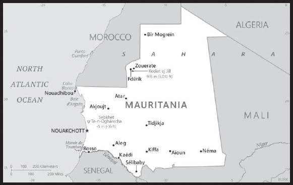
INTRODUCTION
Background: The Berber and Bafour people were among the first to settle in what is now Mauritania. Originally a nomadic people, they were among the first in recorded history to convert from a nomadic to agricultural lifestyle. These groups account for roughly one third of Mauritania’s ethnic makeup. The remainder of Mauritania’s ethnic groups derive from former enslaved peoples and Sub-Saharan ethnic groups originating mainly from the Senegal River Valley. These three groups are organized according to a strict caste system with deep ethnic divides that still exist today.
A former French colony, Mauritania achieved independence from France in 1960. Mauritania initially began as a single-party, authoritarian regime and saw 49 years of dictatorships, flawed elections, failed attempts at democracy, and military coups. Ould Abdel AZIZ led the last coup in 2008, and was elected president in 2009 and reelected in 2014. Mohamed Ould Cheikh GHAZOUANI was elected president in 2019, and his inauguration marked the first peaceful transition of power from one democratically elected president to another, solidifying Mauritania’s status as an emerging democracy. International observers recognized the elections as relatively free and fair.
The country is working to address a continuing practice of slavery and its vestiges. Mauritania officially abolished slavery in 1981, but the practice was not criminalized until 2007. Between 2005 and 2011, Al-Qaeda in the Islamic Maghreb (AQIM) launched a series of attacks killing American and foreign tourists and aid workers, attacking diplomatic and government facilities, and ambushing Mauritanian soldiers and gendarmes. Although Mauritania has not seen an attack since 2011, AQIM and similar groups remain active in the Sahel region.
GEOGRAPHY
Location: Western Africa, bordering the North Atlantic Ocean, between Senegal and Western Sahara
Geographic coordinates: 20 00 N, 12 00 W
Map references: Africa
Area: total: 1,030,700 sq km
land: 1,030,700 sq km
water: 0 sq km
comparison ranking: total 30
Area - comparative: slightly larger than three times the size of New Mexico; about six times the size of Florida
Land boundaries: total: 5,002 km
border countries (4): Algeria 460 km; Mali 2,236 km; Morocco 1,564 km; Senegal 742 km
Coastline: 754 km
Maritime claims: territorial sea: 12 nm
contiguous zone: 24 nm
exclusive economic zone: 200 nm
continental shelf: 200 nm or to the edge of the continental margin
Climate: desert; constantly hot, dry, dusty
Terrain: mostly barren, flat plains of the Sahara; some central hills
Elevation: highest point: Kediet Ijill 915 m
lowest point: Sebkhet Te-n-Dghamcha -5 m
mean elevation: 276 m
Natural resources: iron ore, gypsum, copper, phosphate, diamonds, gold, oil, fish
Land use: agricultural land: 38.5% (2018 est.)
arable land: 0.4% (2018 est.)
permanent crops: 0% (2018 est.)
permanent pasture: 38.1% (2018 est.)
forest: 0.2% (2018 est.)
other: 61.3% (2018 est.)
Irrigated land: 450 sq km (2012)
Major rivers (by length in km): Senegal river mouth (shared with Guinea [s], Senegal and Mali) - 1,641 km
note – [s] after country name indicates river source; [m] after country name indicates river mouth
Major watersheds (area sq km): Atlantic Ocean drainage: Niger (2,261,741 sq km), Senegal (456,397 sq km)
Major aquifers: Senegalo-Mauritanian Basin, Taodeni-Tanzerouft Basin
Population distribution: with most of the country being a desert, vast areas of the country, particularly in the central, northern, and eastern areas, are without sizeable population clusters; half the population lives in or around the coastal capital of Nouakchott; smaller clusters are found near the southern border with Mali and Senegal as shown in this population distribution map
Natural hazards: hot, dry, dust/sand-laden sirocco wind primarily in March and April; periodic droughts
Geography - note: Mauritania is considered both a part of North Africa’s Maghreb region and West Africa’s Sahel region; most of the population is concentrated in the cities of Nouakchott and Nouadhibou and along the Senegal River in the southern part of the country
PEOPLE AND SOCIETY
Population: 4,244,878 (2023 est.)
comparison ranking: 128
Nationality: noun: Mauritanian(s)
adjective: Mauritanian
Ethnic groups: Black Moors (Haratines - Arabic-speaking descendants of African origin who are or were enslaved by White Moors) 40%, White Moors (of Arab-Berber descent, known as Beydane) 30%, Sub-Saharan Mauritanians (non-Arabic speaking, largely resident in or originating from the Senegal River Valley, including Halpulaar, Fulani, Soninke, Wolof, and Bambara ethnic groups) 30%
Languages: Arabic (official and national), Pular, Soninke, Wolof (all national languages), French; note - the spoken Arabic in Mauritania differs considerably from the Modern Standard Arabic used for official written purposes or in the media; the Mauritanian dialect, which incorporates many Berber words, is referred to as Hassaniya
major-language sample(s):
(Arabic)
Religions: Muslim (official) 100%
Demographic profile: With a sustained total fertility rate of about 3.5 children per woman and almost 60% of the population under the age of 25 as of 2020, Mauritania’s population is likely to continue growing for the foreseeable future. Mauritania’s large youth cohort is vital to its development prospects, but available schooling does not adequately prepare students for the workplace. Girls continue to be underrepresented in the classroom, educational quality remains poor, and the dropout rate is high. The literacy rate is only about 50%, even though access to primary education has improved since the mid-2000s. Women’s restricted access to education and discriminatory laws maintain gender inequality - worsened by early and forced marriages and female genital cutting.
The denial of education to black Moors also helps to perpetuate slavery. Although Mauritania abolished slavery in 1981 (the last country in the world to do so) and made it a criminal offense in 2007, the millenniums-old practice persists largely because anti-slavery laws are rarely enforced and the custom is so ingrained. According to a 2018 nongovernmental organization’s report, a little more than 2% of Mauritania’s population is enslaved, which includes individuals subjected to forced labor and forced marriage, while many thousands of individuals who are legally free contend with discrimination, poor education, and a lack of identity papers and, therefore, live in de facto slavery. The UN and international press outlets have claimed that up to 20% of Mauritania’s population is enslaved, which would be the highest rate worldwide.
Drought, poverty, and unemployment have driven outmigration from Mauritania since the 1970s. Early flows were directed toward other West African countries, including Senegal, Mali, Cote d’Ivoire, and Gambia. The 1989 Mauritania-Senegal conflict forced thousands of black Mauritanians to take refuge in Senegal and pushed labor migrants toward the Gulf, Libya, and Europe in the late 1980s and early 1990s. Mauritania has accepted migrants from neighboring countries to fill labor shortages since its independence in 1960 and more recently has received refugees escaping civil wars, including tens of thousands of Tuaregs who fled Mali in 2012.
Mauritania was an important transit point for Sub-Saharan migrants moving illegally to North Africa and Europe. In the mid-2000s, as border patrols increased in the Strait of Gibraltar, security increased around Spain’s North African enclaves (Ceuta and Melilla), and Moroccan border controls intensified, illegal migration flows shifted from the Western Mediterranean to Spain’s Canary Islands. In 2006, departure points moved southward along the West African coast from Morocco and then Western Sahara to Mauritania’s two key ports (Nouadhibou and the capital Nouakchott), and illegal migration to the Canaries peaked at almost 32,000. The numbers fell dramatically in the following years because of joint patrolling off the West African coast by Frontex (the EU’s border protection agency), Spain, Mauritania, and Senegal; the expansion of Spain’s border surveillance system; and the 2008 European economic downturn.
Age structure: 0-14 years: 36.11% (male 769,229/female 763,465)
15-64 years: 59.58% (male 1,197,311/female 1,331,815)
65 years and over: 4.31% (2023 est.) (male 77,123/female 105,935)
Dependency ratios: total dependency ratio: 82.7
youth dependency ratio: 76.8
elderly dependency ratio: 6
potential support ratio: 16.8 (2021 est.)
Median age: total: 21 years (2020)
male: 20.1 years
female: 22 years
comparison ranking: total 186
Population growth rate: 1.96% (2023 est.)
comparison ranking: 40
Birth rate: 27.61 births/1,000 population (2023 est.)
comparison ranking: 36
Death rate: 7.33 deaths/1,000 population (2023 est.)
comparison ranking: 108
Net migration rate: -0.71 migrant(s)/1,000 population (2023 est.)
comparison ranking: 135
Population distribution: with most of the country being a desert, vast areas of the country, particularly in the central, northern, and eastern areas, are without sizeable population clusters; half the population lives in or around the coastal capital of Nouakchott; smaller clusters are found near the southern border with Mali and Senegal as shown in this population distribution map
Urbanization: urban population: 57.7% of total population (2023)
rate of urbanization: 3.84% annual rate of change (2020-25 est.)
Major urban areas - population: 1.492 million NOUAKCHOTT (capital) (2023)
Sex ratio: at birth: 1.03 male(s)/female
0-14 years: 1.01 male(s)/female
15-64 years: 0.9 male(s)/female
65 years and over: 0.73 male(s)/female
total population: 0.93 male(s)/female (2023 est.)
Mother’s mean age at first birth: 21.8 years (2019/21)
note: data represents median age at first birth among women 25-49
Maternal mortality ratio: 465 deaths/100,000 live births (2020 est.)
comparison ranking: 16
Infant mortality rate: total: 49.95 deaths/1,000 live births (2023 est.)
male: 55.84 deaths/1,000 live births
female: 43.89 deaths/1,000 live births
comparison ranking: total 18
Life expectancy at birth: total population: 65.57 years (2023 est.)
male: 63.1 years
female: 68.12 years
comparison ranking: total population 204
Total fertility rate: 3.46 children born/woman (2023 est.)
comparison ranking: 37
Gross reproduction rate: 1.71 (2023 est.)
Contraceptive prevalence rate: 11.5% (2019/20)
Drinking water source: improved: urban: 98.7% of population
rural: 68.4% of population
total: 85.2% of population
unimproved: urban: 1.3% of population
rural: 31.6% of population
total: 14.8% of population (2020 est.)
Current health expenditure: 3.4% of GDP (2020)
Physicians density: 0.19 physicians/1,000 population (2018)
Sanitation facility access: improved: urban: 83.5% of population
rural: 25.2% of population
total: 57.5% of population
unimproved: urban: 16.5% of population
rural: 74.8% of population
total: 42.5% of population (2020 est.)
Major infectious diseases: degree of risk: very high (2023)
food or waterborne diseases: bacterial and protozoal diarrhea, hepatitis A, and typhoid fever
vectorborne diseases: malaria and dengue fever
animal contact diseases: rabies
respiratory diseases: meningococcal meningitis
Obesity - adult prevalence rate: 12.7% (2016)
comparison ranking: 132
Alcohol consumption per capita: total: 0 liters of pure alcohol (2019 est.)
beer: 0 liters of pure alcohol (2019 est.)
wine: 0 liters of pure alcohol (2019 est.)
spirits: 0 liters of pure alcohol (2019 est.)
other alcohols: 0 liters of pure alcohol (2019 est.)
comparison ranking: total 186
Tobacco use: total: 10.7% (2020 est.)
male: 19.3% (2020 est.)
female: 2.1% (2020 est.)
comparison ranking: total 133
Children under the age of 5 years underweight: 22.4% (2022)
comparison ranking: 11
Currently married women (ages 15-49): 66% (2023 est.)
Child marriage: women married by age 15: 15.5%
women married by age 18: 36.6%
men married by age 18: 1.2% (2021 est.)
Education expenditures: 1.9% of GDP (2020 est.)
comparison ranking: 189
Literacy: definition: age 15 and over can read and write
total population: 67%
male: 71.8%
female: 62.2% (2021)
School life expectancy (primary to tertiary education): total: 9 years
male: 8 years
female: 9 years (2020)
Youth unemployment rate (ages 15-24): total: 23% (2021 est.)
male: 20.8%
female: 27.9%
comparison ranking: total 70
ENVIRONMENT
Environment - current issues: overgrazing, deforestation, and soil erosion aggravated by drought are contributing to desertification; limited natural freshwater resources away from the Senegal, which is the only perennial river; locust infestation
Environment - international agreements: party to: Biodiversity, Climate Change, Climate Change-Kyoto Protocol, Climate Change-Paris Agreement, Comprehensive Nuclear Test Ban, Desertification, Endangered Species, Hazardous Wastes, Law of the Sea, Nuclear Test Ban, Ozone Layer Protection, Ship Pollution, Wetlands, Whaling
signed, but not ratified: none of the selected agreements
Climate: desert; constantly hot, dry, dusty
Land use: agricultural land: 38.5% (2018 est.)
arable land: 0.4% (2018 est.)
permanent crops: 0% (2018 est.)
permanent pasture: 38.1% (2018 est.)
forest: 0.2% (2018 est.)
other: 61.3% (2018 est.)
Urbanization: urban population: 57.7% of total population (2023)
rate of urbanization: 3.84% annual rate of change (2020-25 est.)
Food insecurity: widespread lack of access: due to high food prices - according to the latest analysis, nearly 695,000 people are projected to be in need of humanitarian assistance during the June to August 2023 lean season; this would be an improvement compared to the previous year, mostly due to the substantial cereal production increase in 2022; high food prices continue to worsen food security, while flooding in 2022, which affected about 54,000 people, has further aggravated the conditions of vulnerable households (2023)
Revenue from forest resources: 1.3% of GDP (2018 est.)
comparison ranking: 48
Revenue from coal: 0% of GDP (2018 est.)
comparison ranking: 174
Air pollutants: particulate matter emissions: 41.98 micrograms per cubic meter (2019 est.)
carbon dioxide emissions: 2.74 megatons (2016 est.)
methane emissions: 6.16 megatons (2020 est.)
Waste and recycling: municipal solid waste generated annually: 454,000 tons (2009 est.)
municipal solid waste recycled annually: 36,320 tons (2009 est.)
percent of municipal solid waste recycled: 8% (2009 est.)
Major rivers (by length in km): Senegal river mouth (shared with Guinea [s], Senegal and Mali) - 1,641 km
note – [s] after country name indicates river source; [m] after country name indicates river mouth
Major watersheds (area sq km): Atlantic Ocean drainage: Niger (2,261,741 sq km), Senegal (456,397 sq km)
Major aquifers: Senegalo-Mauritanian Basin, Taodeni-Tanzerouft Basin
Total water withdrawal: municipal: 100 million cubic meters (2020 est.)
industrial: 30 million cubic meters (2020 est.)
agricultural: 1.2 billion cubic meters (2020 est.)
Total renewable water resources: 11.4 billion cubic meters (2020 est.)
GOVERNMENT
Country name: conventional long form: Islamic Republic of Mauritania
conventional short form: Mauritania
local long form: Al Jumhuriyah al Islamiyah al Muritaniyah
local short form: Muritaniyah
etymology: named for the ancient kingdom of Mauretania (3rd century B.C. to 1st century A.D.) and the subsequent Roman province (1st-7th centuries A.D.), which existed further north in present-day Morocco; the name derives from the Mauri (Moors), the Berber-speaking peoples of northwest Africa
Government type: presidential republic
Capital: name: Nouakchott
geographic coordinates: 18 04 N, 15 58 W
time difference: UTC 0 (5 hours ahead of Washington, DC, during Standard Time)
etymology: may derive from the Berber “nawakshut” meaning “place of the winds”
Administrative divisions: 15 regions (wilayas, singular - wilaya); Adrar, Assaba, Brakna, Dakhlet Nouadhibou, Gorgol, Guidimaka, Hodh ech Chargui, Hodh El Gharbi, Inchiri, Nouakchott Nord, Nouakchott Ouest, Nouakchott Sud, Tagant, Tiris Zemmour, Trarza
Independence: 28 November 1960 (from France)
National holiday: Independence Day, 28 November (1960)
Constitution: history: previous 1964; latest adopted 12 July 1991
amendments: proposed by the president of the republic or by Parliament; consideration of amendments by Parliament requires approval of at least one third of the membership; a referendum is held only if the amendment is approved by two-thirds majority vote; passage by referendum requires simple majority vote by eligible voters; passage of amendments proposed by the president can bypass a referendum if approved by at least three-fifths majority vote by Parliament; amended 2006, 2012, 2017
Legal system: mixed legal system of Islamic and French civil law
International law organization participation: has not submitted an ICJ jurisdiction declaration; non-party state to the ICCt
Citizenship: citizenship by birth: no
citizenship by descent only: at least one parent must be a citizen of Mauritania
dual citizenship recognized: no
residency requirement for naturalization: 5 years
Suffrage: 18 years of age; universal
Executive branch: chief of state: President Mohamed Ould Cheikh el GHAZOUANI (since 1 August 2019)
head of government: Prime Minister Mohamed Ould BILAL (since 6 August 2020)
cabinet: Council of Ministers - nominees suggested by the prime minister, appointed by the president
elections/appointments: president directly elected by absolute majority popular vote in 2 rounds if needed for a 5-year term (eligible for a second term); election last held on 22 June 2019 (next to be held on 22 June 2024); prime minister appointed by the president
election results:
2019: Mohamed Ould Cheikh El GHAZOUANI elected president in first round; percent of vote - Mahamed Ould Cheikh El GHAZOUANI (UPR) 52%, Biram Dah Ould ABEID (independent) 18.6%, Sidi Mohamed Ould BOUBACAR (independent) 17.9%, other 11.5%
2014: Mohamed Ould Abdel AZIZ elected president in first round; percent of vote - Mohamed Ould Abdel AZIZ (UPR) 81.9%, Biram Dah ABEID (IRA) 8.7%, Boidiel Ould HOUMEIT (El Wiam) 4.5%, Ibrahima Moctar SARR (SJD/MR) 4.4%, other 0.5%
Legislative branch: description: unicameral Parliament or Barlamane consists of the National Assembly or Al Jamiya Al Wataniya (176 seats statutory; 88 members filled from one or two seat constituencies elected by a two-round majority system and the other 88 members filled from a single, nationwide constituency directly elected by proportional representation vote); 20 seats are reserved for women candidates in the nationwide constituency, 11 seats are reserved for young candidates (aged between 25 and 35), and 4 members directly elected by the diaspora; all members serve 5-year terms
elections: last held in 2 rounds on 13 and 27 May 2023 (next to be held in May 2028)
election results: National Assembly - percent of vote by party - NA; seats by party - El INSAF 107, Tawassoul 11, UDP 10, FRUD (Republican Front for Unity and Democracy) 7, El Islah (Reformist Party) 6, National Democratic Alliance (AND) 6, El Karama (Dignity Party) 5, Nida Al-Watan 5, Sawab 5, Alliance for Justice and Democracy/Movement for Renewal 4, Hiwar 3, Mauritanian Party for Union and Change (HATEM) 3, El Vadila (Party of Virtue) 2, Union for Planning and Construction (UPC) 1, Party of the Mauritanian Masses (Hakam) 1; composition - men, 135, women 41, percent of women elected 23.3%
note - the early parliamentary elections in 2023 were the first to be held under President Mohamed Ould Cheikh El Ghazouani, elected in 2019 in a first peaceful transition of power; the elections followed the agreement between the government and parties in September 2022 to renew the Independent National Electoral Commission (CENI) and hold the elections in the first semester of 2023 for climatic and logistical reasons
Judicial branch: highest court(s): Supreme Court or Cour Supreme (subdivided into 7 chambers: 2 civil, 2 labor, 1 commercial, 1 administrative, and 1 criminal, each with a chamber president and 2 councilors); Constitutional Council (consists of 9 members); High Court of Justice (consists of 9 members)
judge selection and term of office: Supreme Court president appointed by the president of the republic to serve a 5-year renewable term; Constitutional Council members appointed - 3 by the president of the republic, 2 by the president of the National Assembly, 1 by the prime minister, 1 by the leader of the democratic opposition, 1 by the largest opposition party in the National Assembly, and 1 by the second largest party in the National Assembly; members serve single, 9-year terms with one-third of membership renewed every 3 years; High Court of Justice members appointed by Parliament - 6 by the ruling Coalition of Majority Parties and 3 by opposition parties
subordinate courts: Courts of Appeal; courts of first instance or wilya courts are established in the regions’ headquarters and include commercial and labor courts, criminal courts, Moughataa (district) Courts, and informal/customary courts
Political parties and leaders: Alliance for Justice and Democracy/Movement for Renewal or AJD/MR [Ibrahima Moctar SARR]
El Insaf or Equity Party [Mohamed Melainine Ould EYIH]
El Islah Party [Mohamed Ould TALEBNA]
El Karama Party [Cheikhna Ould Mohamed Ould HAJBOU]
El Vadila [Ethmane Ould Cheikh Ahmed Eboul MEALY]
FRUD (Republican Front for Unity and Democracy) [Kadiata Malick DIALLO]
Mauritanian Party of Union and Change (HATEM) [Saleh Ould HANENNA]
National Democratic Alliance or AND [Yacoub Ould MOINE]
National Rally for Reform and Development or RNRD or TAWASSOUL [Hamadi Ould Sidi MOKHTAR]
Nida El-Watan [Daoud Ould Ahmed AICHA]
Party for Conciliation and Prosperity or HIWAR [Valle Mint Mini]
Party of the Mauritanian Masses (Hakam) [El Khalil Ould ENNAHOUI]
Sawab Party [Ahmed Salem Ould HORMA]
Union for Democracy and Progress or UDP [Naha Mint MOUKNASS]
Union of Planning and Construction (UPC) [Qari Ould Mohamed ABDALLAHI]
note: only parties with seats in the National Assembly listed
International organization participation: ABEDA, ACP, AfDB, AFESD, AMF, AMU, AU, CAEU, EITI (compliant country), FAO, G-77, IAEA, IBRD, ICAO, ICC (NGOs), ICRM, IDA, IDB, IFAD, IFC, IFRCS, IHO (pending member), ILO, IMF, IMO, Interpol, IOC, IOM, IPU, ISO (correspondent), ITSO, ITU, ITUC (NGOs), LAS, MIGA, MIUSMA, NAM, OIC, OIF, OPCW, UN, UNCTAD, UNESCO, UNHRC, UNIDO, UNWTO, UPU, WCO, WHO, WIPO, WMO, WTO
Diplomatic representation in the US: chief of mission: Ambassador BOIDE Cisse (since 15 September 2021)
chancery: 2129 Leroy Place NW, Washington, DC 20008
telephone: [1] (202) 232-5700
FAX: [1] (202) 319-2623
email address and website:
ambarimwashington@diplomatie.gov.mr; ambarimwash@gmail.com
mauritaniaembassyus.org – Mauritania Embassy washington
Diplomatic representation from the US: chief of mission: Ambassador Cynthia KIERSCHT (since 27 January 2021)
embassy: Nouadhibou Road, Avenue Al Quds, NOT PRTZ, Nouakchott
mailing address: 2430 Nouakchott Place, Washington DC 20521-2430
telephone: [222] 4525-2660
FAX: [222] 4525-1592
email address and website:
Flag description: green with a yellow, five-pointed star between the horns of a yellow, upward-pointing crescent moon; red stripes along the top and bottom edges; the crescent, star, and color green are traditional symbols of Islam; green also represents hope for a bright future; the yellow color stands for the sands of the Sahara; red symbolizes the blood shed in the struggle for independence
National symbol(s): five-pointed star between the horns of a horizontal crescent moon; national colors: green, yellow
National anthem: name: “Bila¯da l-’uba¯ti l-huda¯ti l-kira¯m” (Land of the Proud, Guided by Noblemen)
lyrics/music: unknown/traditional, Rageh DAOUD
note: adopted 16 November 2017
National heritage: total World Heritage Sites: 2 (1 cultural, 1 natural)
selected World Heritage Site locales: Ancient Ksour (Fortified Villages) of Ouadane, Chinguetti, Tichitt, and Oualata (c); Banc d’Arguin National Park (n)
ECONOMY
Economic overview: lower middle-income West African economy; primarily agrarian; rising urbanization; poor property rights; systemic corruption; endemic social and workforce tensions; wide-scale terrorism; foreign over-fishing; environmentally fragile
Real GDP (purchasing power parity): $24.494 billion (2021 est.)
$23.909 billion (2020 est.)
$24.136 billion (2019 est.)
note: data are in 2017 dollars
comparison ranking: 146
Real GDP growth rate: 2.45% (2021 est.)
-0.94% (2020 est.)
5.3% (2019 est.)
comparison ranking: 155
Real GDP per capita: $5,300 (2021 est.)
$5,300 (2020 est.)
$5,500 (2019 est.)
note: data are in 2017 dollars
comparison ranking: 174
GDP (official exchange rate): $706 million (2018 est.)
Inflation rate (consumer prices): 3.57% (2021 est.)
2.39% (2020 est.)
2.3% (2019 est.)
comparison ranking: 106
GDP - composition, by sector of origin: agriculture: 27.8% (2017 est.)
industry: 29.3% (2017 est.)
services: 42.9% (2017 est.)
comparison rankings: services 202; industry 82; agriculture 22
GDP - composition, by end use: household consumption: 64.9% (2017 est.)
government consumption: 21.8% (2017 est.)
investment in fixed capital: 56.1% (2017 est.)
investment in inventories: -3.2% (2017 est.)
exports of goods and services: 39% (2017 est.)
imports of goods and services: -78.6% (2017 est.)
Agricultural products: rice, milk, goat milk, sheep milk, sorghum, mutton, beef, camel milk, camel meat, dates
Industries: fish processing, oil production, mining (iron ore, gold, copper)
note: gypsum deposits have never been exploited
Industrial production growth rate: -6.61% (2021 est.)
comparison ranking: 191
Labor force: 1.197 million (2021 est.)
comparison ranking: 139
Labor force - by occupation: agriculture: 50%
industry: 1.9%
services: 48.1% (2014 est.)
Unemployment rate: 11.46% (2021 est.)
11.27% (2020 est.)
10.39% (2019 est.)
comparison ranking: 61
Youth unemployment rate (ages 15-24): total: 23% (2021 est.)
male: 20.8%
female: 27.9%
comparison ranking: total 70
Population below poverty line: 31% (2014 est.)
Gini Index coefficient - distribution of family income: 32.6 (2014 est.)
comparison ranking: 131
Household income or consumption by percentage share: lowest 10%: 2.5%
highest 10%: 29.5% (2000)
Budget: revenues: $1.617 billion (2019 est.)
expenditures: $1.407 billion (2019 est.)
Budget surplus (+) or deficit (-): -0.8% (of GDP) (2017 est.)
comparison ranking: 70
Public debt: 96.6% of GDP (2017 est.)
100% of GDP (2016 est.)
comparison ranking: 29
Taxes and other revenues: 27.4% (of GDP) (2017 est.)
comparison ranking: 37
Fiscal year: calendar year
Current account balance: -$807.862 million (2021 est.)
-$576.175 million (2020 est.)
-$831.106 million (2019 est.)
comparison ranking: 134
Exports: $3.18 billion (2021 est.) note: data are in current year dollars
$2.784 billion (2020 est.) note: data are in current year dollars
$2.525 billion (2019 est.)
comparison ranking: 148
Exports - partners: China 32%, Switzerland 13%, Spain 9%, Japan 9%, Italy 5% (2019)
Exports - commodities: iron ore, gold, mollusks and shellfish, frozen fish, copper ore (2021)
Imports: $4.312 billion (2021 est.) note: data are in current year dollars
$3.675 billion (2020 est.) note: data are in current year dollars
$3.683 billion (2019 est.)
comparison ranking: 148
Imports - partners: China 26%, France 6%, Spain 6%, Morocco 6%, United Arab Emirates 5% (2019)
Imports - commodities: ships, aircraft, wheat, raw sugar, refined petroleum (2019)
Reserves of foreign exchange and gold: $2.039 billion (31 December 2021 est.)
$1.493 billion (31 December 2020 est.)
$1.029 billion (31 December 2019 est.)
comparison ranking: 130
Debt - external: $4.15 billion (31 December 2017 est.)
$3.899 billion (31 December 2016 est.)
comparison ranking: 139
Exchange rates: ouguiyas (MRO) per US dollar -
Exchange rates: 36.063 (2021 est.)
37.189 (2020 est.)
36.691 (2019 est.)
35.678 (2018 est.)
35.794 (2017 est.)
ENERGY
Electricity access: population without electricity: 3 million (2020)
electrification - total population: 47.6% (2021)
electrification - urban areas: 89.6% (2021)
electrification - rural areas: 1% (2020)
Electricity: installed generating capacity: 656,000 kW (2020 est.)
consumption: 1.577 billion kWh (2019 est.)
exports: 0 kWh (2019 est.)
imports: 0 kWh (2019 est.)
transmission/distribution losses: 245 million kWh (2019 est.)
comparison rankings: installed generating capacity 142; transmission/distribution losses 145; imports 210; exports 210; consumption 152
Electricity generation sources: fossil fuels: 73.2% of total installed capacity (2020 est.)
solar: 8.1% of total installed capacity (2020 est.)
wind: 6.8% of total installed capacity (2020 est.)
hydroelectricity: 11.9% of total installed capacity (2020 est.)
Petroleum: total petroleum production: 0 bbl/day (2021 est.)
refined petroleum consumption: 27,500 bbl/day (2019 est.)
crude oil and lease condensate exports: 4,800 bbl/day (2018 est.)
crude oil and lease condensate imports: 0 bbl/day (2018 est.)
crude oil estimated reserves: 20 million barrels (2021 est.)
Refined petroleum products - imports: 17,290 bbl/day (2015 est.)
comparison ranking: 133
Natural gas: proven reserves: 28.317 billion cubic meters (2021 est.)
Carbon dioxide emissions: 4.041 million metric tonnes of CO2 (2019 est.)
from petroleum and other liquids: 4.041 million metric tonnes of CO2 (2019 est.)
comparison ranking: total emissions 141
Energy consumption per capita: 13.558 million Btu/person (2019 est.)
comparison ranking: 145
COMMUNICATIONS
Telephones - fixed lines: total subscriptions: 58,094 (2021 est.)
subscriptions per 100 inhabitants: 1 (2021 est.)
comparison ranking: total subscriptions 151
Telephones - mobile cellular: total subscriptions: 6,512,361 (2021 est.)
subscriptions per 100 inhabitants: 141 (2021 est.)
comparison ranking: total subscriptions 112
Telecommunication systems: general assessment: Mauritania’s small population and low economic output has limited the country’s ability to develop sustained growth in the telecom sector; low disposable income has restricted growth in the use of services, and thus of revenue which telcos can hope to gain from subscribers; this has impacted on their ability to invest in network upgrades and improvements to service offerings; this has been reflected in the repeated fines imposed against them by the regulator for failing to ensure a good quality of service; there are also practical challenges relating to transparency and tax burdens which have hindered foreign investment; financial support has been forthcoming from the government as well as the World Bank and European Investment Bank; their efforts have focused on implementing appropriate regulatory measures and promoting the further penetration of fixed-line broadband services by improving the national backbone network, ensuring connectivity to international telecom cables, and facilitating operator access to infrastructure; progress has been made to improve internet bandwidth capacity, including the completion of a cable link at the border with Algeria, and the connection to the EllaLink submarine cable; the final stage of the national backbone network was completed in December 2021, which now runs to some 4,000km; penetration of fixed telephony and broadband service is very low and is expected to remain so in coming years, though growth is anticipated following improvements to backbone infrastructure and the reduction in access pricing; most voice and data services are carried over the mobile networks (2022)
domestic: fixed-line teledensity 1 per 100 persons; mobile-cellular teledensity of roughly 141 per 100 persons (2021)
international: country code - 222; landing point for the ACE submarine cable for connectivity to 19 West African countries and 2 European countries; satellite earth stations - 3 (1 Intelsat - Atlantic Ocean, 2 Arabsat) (2019)
Broadcast media: 12 TV stations: 6 government-owned and 6 private (the 6th was started in early 2022, owed by the President of Mauritanian Businessmen); in October 2017, the government suspended most private TV stations due to non-payment of broadcasting fees, but they later negotiated payment options with the government and are back since 2019. There are 19 radio broadcasters: 15 government-owned, 4 (Radio Nouakchott Libre, Radio Tenwir, Radio Kobeni and Mauritanid) private; all 4 private radio stations broadcast from Nouakchott; of the 15 government stations, 4 broadcast from Nouakchott (Radio Mauritanie, Radio Jeunesse, Radio Koran and Mauritanid) and the other 12 broadcast from each of the 12 regions outside Nouakchott; Radio Jeunesse and Radio Koran are now also being re-broadcast in all the regions. (2022)
Internet country code: .mr
Internet users: total: 2.714 million (2021 est.)
percent of population: 59% (2021 est.)
comparison ranking: total 125
Broadband - fixed subscriptions: total: 18,457 (2020 est.)
subscriptions per 100 inhabitants: 0.4 (2020 est.)
comparison ranking: total 168
TRANSPORTATION
National air transport system: number of registered air carriers: 1 (2020)
inventory of registered aircraft operated by air carriers: 6
annual passenger traffic on registered air carriers: 454,435 (2018)
Civil aircraft registration country code prefix: 5T
Airports: 30 (2021)
comparison ranking: total 115
Airports - with paved runways: 9
note: paved runways have a concrete or asphalt surface but not all have facilities for refueling, maintenance, or air traffic control; the length of a runway required for aircraft to safely operate depends on a number of factors including the type of aircraft, the takeoff weight (including passengers, cargo, and fuel), engine types, flap settings, landing speed, elevation of the airport, and average maximum daily air temperature; paved runways can reach a length of 5,000 m (16,000 ft.), but the “typical” length of a commercial airline runway is between 2,500-4,000 m (8,000-13,000 ft.)
Airports - with unpaved runways: 21
note: unpaved runways have a surface composition such as grass or packed earth and are most suited to the operation of light aircraft; unpaved runways are usually short, often less than 1,000 m (3,280 ft.) in length; airports with unpaved runways often lack facilities for refueling, maintenance, or air traffic control
Railways: total: 728 km (2014)
standard gauge: 728 km (2014) 1.435-m gauge
comparison ranking: total 98
Roadways: total: 12,253 km (2018)
paved: 3,988 km (2018)
unpaved: 8,265 km (2018)
comparison ranking: total 131
Waterways: 1,086 km (2022) (some navigation possible on the Senegal River)
comparison ranking: 67
Merchant marine: total: 11 (2022)
by type: general cargo 2, other 9
comparison ranking: total 155
Ports and terminals: major seaport(s): Nouadhibou, Nouakchott
MILITARY AND SECURITY
Military and security forces: Mauritanian Armed Forces (aka Armée Nationale Mauritanienne): National Army, National Navy (Marine Nationale), Mauritania Islamic Air Force; Gendarmerie (Ministry of Defense)
Ministry of Interior and Decentralization: National Police, National Guard, General Group for Road Safety (2023)
note 1: the National Police are responsible for enforcing the law and maintaining order in urban areas, while the paramilitary Gendarmerie is responsible for maintaining civil order around metropolitan areas and providing law enforcement services in rural areas; like the Mauritanian Armed Forces, the Gendarmerie is under the Ministry of Defense, but also supports the ministries of Interior and Justice
note 2: the National Guard performs a limited police function in keeping with its peacetime role of providing security at government facilities, to include prisons; regional authorities may call upon the National Guard to restore civil order during riots and other large-scale disturbances
note 3: the General Group for Road Safety maintains security on roads and operates checkpoints throughout the country
Military expenditures: 2.5% of GDP (2022 est.)
2.4% of GDP (2021 est.)
2.5% of GDP (2020 est.)
2.1% of GDP (2019 est.)
2.3% of GDP (2018 est.)
comparison ranking: 44
Military and security service personnel strengths: approximately 16,000 Mauritanian Armed Forces personnel (15,000 Army; 700 Navy; 300 Air Force); estimated 3,000 Gendarmerie; estimated 2,000 National Guard (2023)
Military equipment inventories and acquisitions: the military’s inventory is limited and made up largely of older French and Soviet-era equipment; in recent years, Mauritania has received small amounts of mostly secondhand military equipment from a variety of suppliers, with China as the leading provider (2023)
Military service age and obligation: 18 is the legal minimum age for voluntary military service; has a compulsory two-year military service law, but the law has reportedly never been applied (2022)
Military deployments: 450 (plus about 320 police) Central African Republic (MINUSCA) (2023)
note: Mauritania is part of a four (formerly five)-nation anti-jihadist task force known as the G4 Sahel Group, set up in 2014 with Burkina Faso, Chad, Mali (withdrew in 2022), and Niger; it has committed 550 troops and 100 gendarmes to the force; as of 2020, defense forces from each of the participating states were allowed to pursue terrorist fighters up to 100 km into neighboring countries; the force is backed by France, the UN, and the US
Military - note: founded in 1960, the Mauritanian military is responsible for territorial defense and internal security; it also assists in economic development projects, humanitarian missions, and disaster response; securing the border and countering terrorist groups operating in the Sahel, particularly from Mali, are key operational priorities; since a spate of deadly terrorist attacks on civilian and military targets in the 2005-2011 timeframe, the Mauritanian Government has increased the defense budget (up 40% between 2008 and 2018) and military equipment acquisitions, enhanced military training, heightened security cooperation with its neighbors and the international community, and built up the military’s counterinsurgency and counterterrorism forces and capabilities; equipment acquisitions have prioritized mobility, flexibility, and intelligence collection, including light ground attack and reconnaissance aircraft, assault helicopters, patrol vessels, light trucks, and surveillance radars; Mauritania has received foreign security assistance from France, NATO, and the US in areas such as commando/special forces operations, counterterrorism, and professional military education
the Army has sought to create lighter, more nimble units capable of operating in the harsh environment of the Sahel; since 2009, for example, it has enhanced existing camel-mounted nomad patrol units and created up to 8 Special Intervention Groups (GSI), 200-man French-trained Army commando/counterterrorism units that are mounted on light vehicles, carry their own supplies, and operate in remote desert border areas for extended periods of time; in addition to the GSI and camel-mounted forces, the Army has multiple motorized infantry battalions, plus individual battalions of tanks, light armored reconnaissance, presidential guards, and airborne/commando forces to supplement garrison units stationed throughout the country in 6 military regions; the Gendarmerie has territorial-based, mobile, and specialized units such rapid reaction forces (Rapid Action Group – Surveillance and Intervention Group or GAR-SI) that conduct counterterrorism missions and work with the regular military services; the Air Force has acquired a few light attack combat aircraft in recent years, but remains small with a total inventory of about 20 patrol, transport, and trainer airplanes and helicopters; in addition to 2 offshore patrol vessels acquired from China in 2016, the Navy has a small force of coastal patrol craft and inshore patrol boats to monitor the country’s 750km-long coastline and Economic Exclusion Zone, plus a unit of marines (Fusiliers Marins); it has conducted joint patrols with the Senegalese Navy along their shared maritime border (2023)
TERRORISM
Terrorist group(s): Terrorist group(s): Al-Qa’ida in the Islamic Maghreb (AQIM)
TRANSNATIONAL ISSUES
Disputes - international: Mauritania-Algeria: none identified
Mauritania-Mali: there are no border disputes, but the border has not been demarcated; talks on demarcation were reportedly being held in February 2022
Mauritania-Morocco: Mauritanian claims to Western Sahara remain dormant; tensions arose in 2016 when Mauritanian soldiers were deployed to Lagouira, a city in the southernmost part of Morocco, and raised their flag
Mauritania-Senegal: none identified
Refugees and internally displaced persons: refugees (country of origin): 26,000 (Sahrawis) (2021); 104,080 (Mali) (2023)
Illicit drugs: NA
MAURITIUS
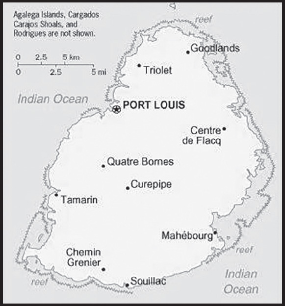
INTRODUCTION
Background: Although known to Arab and European sailors since at least the early 1500s, the island of Mauritius was uninhabited until 1638 when the Dutch established a settlement named in honor of Prince Maurits van NASSAU. Their presence led to the rapid disappearance of the flightless dodo bird that has since become one of the most well-known examples of extinction in modern times. The Dutch abandoned their financially distressed settlement in 1710, although a number of formerly enslaved people remained. In 1722, the French established what would become a highly profitable settlement focused on sugar cane plantations that were reliant on the labor of enslaved people brought to Mauritius from other parts of Africa. In the 1790s, the island had a brief period of autonomous rule when plantation owners rejected French control because of laws ending slavery that were temporarily in effect during the French Revolution. Britain captured the Island in 1810 as part of the Napoleonic Wars but kept most of the French administrative structure, which remains to this day in the form of the country’s legal codes and widespread use of the French Creole language. The abolition of slavery in 1835 - later than most other British colonies - led to increased reliance on contracted laborers from the Indian subcontinent to work on plantations. Today their descendants form the majority of the population. Mauritius remained a strategically important British naval base, and later an air station, playing a role during World War II for anti-submarine and convoy operations, as well as for the collection of signals intelligence.
Mauritius gained independence from the UK in 1968 as a Parliamentary Republic and has remained a stable democracy with regular free elections and a positive human rights record. The country also attracted considerable foreign investment and now has one of Africa’s highest per capita incomes. Mauritius’ often fractious coalition politics has been dominated by two prominent families each of which has had father-son pairs who have been prime minister over multiple, often nonconsecutive, terms. Seewoosagur RAMGOOLAM (1968-76) was Mauritius’ first prime minister and he was succeeded by Anerood JUGNAUTH (1982-95, 2000-03, 2014-17); his son Navin RAMGOOLAM (1995-2000, 2005-14); and Paul Raymond BERENGER (2003-05), the only non-Hindu prime minister of post-independence Mauritius. In 2017, Pravind JUGNAUTH became prime minister after his father stepped down short of completing his term, and he was elected in his own right in 2019. Mauritius claims the French island of Tromelin and the British Chagos Archipelago (British Indian Ocean Territory). Since 2017, Mauritius has secured favorable UN General Assembly resolutions and an International Court of Justice advisory opinion relating to its sovereignty dispute with the UK.
GEOGRAPHY
Location: Southern Africa, island in the Indian Ocean, about 800 km (500 mi) east of Madagascar
Geographic coordinates: 20 17 S, 57 33 E
Map references: Africa
Area: total: 2,040 sq km
land: 2,030 sq km
water: 10 sq km
note: includes Agalega Islands, Cargados Carajos Shoals (Saint Brandon), and Rodrigues comparison ranking: total 180
Area - comparative: almost 11 times the size of Washington, DC
Land boundaries: total: 0 km
Coastline: 177 km
Maritime claims: territorial sea: 12 nm
exclusive economic zone: 200 nm
continental shelf: 200 nm or to the edge of the continental margin measured from claimed archipelagic straight baselines
Climate: tropical, modified by southeast trade winds; warm, dry winter (May to November); hot, wet, humid summer (November to May)
Terrain: small coastal plain rising to discontinuous mountains encircling central plateau
Elevation: highest point: Mont Piton 828 m
lowest point: Indian Ocean 0 m
Natural resources: arable land, fish
Land use: agricultural land: 43.8% (2018 est.)
arable land: 38.4% (2018 est.)
permanent crops: 2% (2018 est.)
permanent pasture: 3.4% (2018 est.)
forest: 17.3% (2018 est.)
other: 38.9% (2018 est.)
Irrigated land: 158 sq km (2020)
Population distribution: population density is one of the highest in the world; urban clusters are found throughout the main island, with a greater density in and around Port Luis; population on Rodrigues Island is spread across the island with a slightly denser cluster on the north coast as shown in this population distribution map
Natural hazards: cyclones (November to April); almost completely surrounded by reefs that may pose maritime hazards
Geography - note: the main island, from which the country derives its name, is of volcanic origin and is almost entirely surrounded by coral reefs; former home of the dodo, a large flightless bird related to pigeons, driven to extinction by the end of the 17th century through a combination of hunting and the introduction of predatory species
PEOPLE AND SOCIETY
Population: 1,309,448 (2023 est.)
comparison ranking: 158
Nationality: noun: Mauritian(s)
adjective: Mauritian
Ethnic groups: Indo-Mauritian (compose approximately two thirds of the total population), Creole, Sino-Mauritian, Franco-Mauritian
note: Mauritius has not had a question on ethnicity on its national census since 1972
Languages: Creole 86.5%, Bhojpuri 5.3%, French 4.1%, two languages 1.4%, other 2.6% (includes English, one of the two official languages of the National Assembly, which is spoken by less than 1% of the population), unspecified 0.1% (2011 est.)
Religions: Hindu 48.5%, Roman Catholic 26.3%, Muslim 17.3%, other Christian 6.4%, other 0.6%, none 0.7%, unspecified 0.1% (2011 est.)
Demographic profile: Mauritius has transitioned from a country of high fertility and high mortality rates in the 1950s and mid-1960s to one with among the lowest population growth rates in the developing world today. After World War II, Mauritius’ population began to expand quickly due to increased fertility and a dramatic drop in mortality rates as a result of improved health care and the eradication of malaria. This period of heightened population growth – reaching about 3% a year – was followed by one of the world’s most rapid birth rate declines.
The total fertility rate fell from 6.2 children per women in 1963 to 3.2 in 1972 – largely the result of improved educational attainment, especially among young women, accompanied by later marriage and the adoption of family planning methods. The family planning programs’ success was due to support from the government and eventually the traditionally pronatalist religious communities, which both recognized that controlling population growth was necessary because of Mauritius’ small size and limited resources. Mauritius’ fertility rate has consistently been below replacement level since the late 1990s, a rate that is substantially lower than nearby countries in southern Africa.
With no indigenous population, Mauritius’ ethnic mix is a product of more than two centuries of European colonialism and continued international labor migration. Sugar production relied on slave labor mainly from Madagascar, Mozambique, and East Africa from the early 18th century until its abolition in 1835, when slaves were replaced with indentured Indians. Most of the influx of indentured labor – peaking between the late 1830s and early 1860s – settled permanently creating massive population growth of more than 7% a year and reshaping the island’s social and cultural composition. While Indians represented about 12% of Mauritius’ population in 1837, they and their descendants accounted for roughly two-thirds by the end of the 19th century. Most were Hindus, but the majority of the free Indian traders were Muslims.
Mauritius again turned to overseas labor when its success in clothing and textile exports led to a labor shortage in the mid-1980s. Clothing manufacturers brought in contract workers (increasingly women) from China, India, and, to a lesser extent Bangladesh and Madagascar, who worked longer hours for lower wages under poor conditions and were viewed as more productive than locals. Downturns in the sugar and textile industries in the mid-2000s and a lack of highly qualified domestic workers for Mauritius’ growing services sector led to the emigration of low-skilled workers and a reliance on skilled foreign labor. Since 2007, Mauritius has pursued a circular migration program to enable citizens to acquire new skills and savings abroad and then return home to start businesses and to invest in the country’s development.
Age structure: 0-14 years: 15.3% (male 102,335/female 97,955)
15-64 years: 71.35% (male 464,380/female 469,877)
65 years and over: 13.36% (2023 est.) (male 72,026/female 102,875)
Dependency ratios: total dependency ratio: 40.7
youth dependency ratio: 23.4
elderly dependency ratio: 17.3
potential support ratio: 5.8 (2021 est.)
Median age: total: 36.3 years (2020)
male: 35 years
female: 37.6 years
comparison ranking: total 80
Population growth rate: 0.09% (2023 est.)
comparison ranking: 188
Birth rate: 9.82 births/1,000 population (2023 est.)
comparison ranking: 189
Death rate: 8.95 deaths/1,000 population (2023 est.)
comparison ranking: 63
Net migration rate: 0 migrant(s)/1,000 population (2023 est.)
comparison ranking: 82
Population distribution: population density is one of the highest in the world; urban clusters are found throughout the main island, with a greater density in and around Port Luis; population on Rodrigues Island is spread across the island with a slightly denser cluster on the north coast as shown in this population distribution map
Urbanization: urban population: 40.9% of total population (2023)
rate of urbanization: 0.28% annual rate of change (2020-25 est.)
Major urban areas - population: 149,000 PORT LOUIS (capital) (2018)
Sex ratio: at birth: 1.07 male(s)/female
0-14 years: 1.04 male(s)/female
15-64 years: 0.99 male(s)/female
65 years and over: 0.7 male(s)/female
total population: 0.95 male(s)/female (2023 est.)
Maternal mortality ratio: 84 deaths/100,000 live births (2020 est.)
comparison ranking: 73
Infant mortality rate: total: 11.84 deaths/1,000 live births (2023 est.)
male: 13.35 deaths/1,000 live births
female: 10.23 deaths/1,000 live births
comparison ranking: total 118
Life expectancy at birth: total population: 75.13 years (2023 est.)
male: 72.32 years
female: 78.13 years
comparison ranking: total population 130
Total fertility rate: 1.35 children born/woman (2023 est.)
comparison ranking: 218
Gross reproduction rate: 0.65 (2023 est.)
Contraceptive prevalence rate: 63.8% (2014)
Drinking water source: improved: urban: 99.9% of population
rural: 99.8% of population
total: 99.9% of population
unimproved: urban: 0.1% of population
rural: 0.2% of population
total: 0.1% of population (2020 est.)
Current health expenditure: 6.7% of GDP (2020)
Physicians density: 2.71 physicians/1,000 population (2020)
Hospital bed density: 3.7 beds/1,000 population (2020)
Sanitation facility access: improved: urban: 99.9% of population
unimproved: urban: 0.1% of population
Obesity - adult prevalence rate: 10.8% (2016)
comparison ranking: 137
Alcohol consumption per capita: total: 3.39 liters of pure alcohol (2019 est.)
beer: 1.94 liters of pure alcohol (2019 est.)
wine: 0.23 liters of pure alcohol (2019 est.)
spirits: 0.88 liters of pure alcohol (2019 est.)
other alcohols: 0.03 liters of pure alcohol (2019 est.)
comparison ranking: total 106
Tobacco use: total: 20.2% (2020 est.)
male: 37.3% (2020 est.)
female: 3% (2020 est.)
comparison ranking: total 88
Currently married women (ages 15-49): 62% (2023 est.)
Education expenditures: 4.9% of GDP (2021 est.)
comparison ranking: 80
Literacy: definition: age 15 and over can read and write
total population: 92.2%
male: 93.5%
female: 90.5% (2021)
School life expectancy (primary to tertiary education): total: 15 years
male: 14 years
female: 16 years (2017)
Youth unemployment rate (ages 15-24): total: 25.3% (2021 est.)
male: 19.7%
female: 32.9%
comparison ranking: total 63
ENVIRONMENT
Environment - current issues: water pollution, degradation of coral reefs; soil erosion; wildlife preservation; solid waste disposal
Environment - international agreements: party to: Antarctic-Marine Living Resources, Biodiversity, Climate Change, Climate Change-Kyoto Protocol, Climate Change-Paris Agreement, Desertification, Endangered Species, Environmental Modification, Hazardous Wastes, Law of the Sea, Marine Life Conservation, Nuclear Test Ban, Ozone Layer Protection, Ship Pollution, Wetlands
signed, but not ratified: none of the selected agreements
Climate: tropical, modified by southeast trade winds; warm, dry winter (May to November); hot, wet, humid summer (November to May)
Land use: agricultural land: 43.8% (2018 est.)
arable land: 38.4% (2018 est.)
permanent crops: 2% (2018 est.)
permanent pasture: 3.4% (2018 est.)
forest: 17.3% (2018 est.)
other: 38.9% (2018 est.)
Urbanization: urban population: 40.9% of total population (2023)
rate of urbanization: 0.28% annual rate of change (2020-25 est.)
Revenue from forest resources: 0% of GDP (2018 est.)
comparison ranking: 171
Revenue from coal: 0% of GDP (2018 est.)
comparison ranking: 77
Air pollutants: particulate matter emissions: 10.48 micrograms per cubic meter (2019 est.)
carbon dioxide emissions: 4.35 megatons (2016 est.)
methane emissions: 2.06 megatons (2020 est.)
Waste and recycling: municipal solid waste generated annually: 438,000 tons (2016 est.)
Total water withdrawal: municipal: 290 million cubic meters (2020 est.)
industrial: 10 million cubic meters (2020 est.)
agricultural: 310 million cubic meters (2020 est.)
Total renewable water resources: 2.75 billion cubic meters (2020 est.)
GOVERNMENT
Country name: conventional long form: Republic of Mauritius
conventional short form: Mauritius
local long form: Republic of Mauritius
local short form: Mauritius
etymology: island named after Prince Maurice VAN NASSAU, stadtholder of the Dutch Republic, in 1598
note: pronounced mah-rish-us
Government type: parliamentary republic
Capital: name: Port Louis
geographic coordinates: 20 09 S, 57 29 E
time difference: UTC+4 (9 hours ahead of Washington, DC, during Standard Time)
etymology: named after LOUIS XV, who was king of France in 1736 when the port became the administrative center of Mauritius and a major reprovisioning stop for French ships traveling between Europe and Asia
Administrative divisions: 9 districts and 3 dependencies*; Agalega Islands*, Black River, Cargados Carajos Shoals*, Flacq, Grand Port, Moka, Pamplemousses, Plaines Wilhems, Port Louis, Riviere du Rempart, Rodrigues*, Savanne
Independence: 12 March 1968 (from the UK)
National holiday: Independence and Republic Day, 12 March (1968 & 1992); note - became independent and a republic on the same date in 1968 and 1992 respectively
Constitution: history: several previous; latest adopted 12 March 1968
amendments: proposed by the National Assembly; passage of amendments affecting constitutional articles, including the sovereignty of the state, fundamental rights and freedoms, citizenship, or the branches of government, requires approval in a referendum by at least three-fourths majority of voters followed by a unanimous vote by the Assembly; passage of other amendments requires only two-thirds majority vote by the Assembly; amended many times, last in 2016
Legal system: civil legal system based on French civil law with some elements of English common law
International law organization participation: accepts compulsory ICJ jurisdiction with reservations; accepts ICCt jurisdiction
Citizenship: citizenship by birth: yes
citizenship by descent only: yes
dual citizenship recognized: yes
residency requirement for naturalization: 5 out of the previous 7 years including the last 12 months
Suffrage: 18 years of age; universal
Executive branch: chief of state: President Prithvirajsing ROOPUN (since 2 December 2019); Vice President Marie Cyril EDDY Boissézon (since 2 December 2019); note - President Ameenah GURIB-FAKIM, the country’s first female president, resigned on 23 March 2018 amid a credit card scandal; acting presidents served from March 2018 until ROOPUN’s appointment in 2019
head of government: Prime Minister Pravind JUGNAUTH (since 23 January 2017); note - Prime Minister Sir Anerood JUGNAUTH stepped down on 23 January 2017 in favor of his son, Pravind Kumar JUGNAUTH, who was then appointed prime minister; following 7 November 2019 parliamentary elections, Pravind JUGNAUTH remained prime minister and home affairs minister and also became defense minister
cabinet: Cabinet of Ministers (Council of Ministers) appointed by the president on the recommendation of the prime minister
elections/appointments: president and vice president indirectly elected by the National Assembly for 5-year renewable terms; election last held on 7 November 2019 (next to be held in 2024); the president appoints the prime minister and deputy prime minister who have the majority support in the National Assembly
election results:
2019: Prithvirajsing ROOPUN (MSM) elected president by the National Assembly - unanimous vote; note - GURIB-FAKIM resigned on 23 March 2018
2015: Ameenah GURIB-FAKIM (independent) elected president by the National Assembly - unanimous vote; note - GURIB-FAKIM was Mauritius’ first female president
Legislative branch: description: unicameral National Assembly or Assemblee Nationale (70 seats maximum; 62 members directly elected multi-seat constituencies by simple majority vote and up to 8 seats allocated to non-elected party candidates by the Office of Electoral Commissioner; members serve a 5-year term)
elections: last held on 7 November 2019 (next to be held by late 2024)
election results: percent of vote by party - Mauritian Alliance 2019 (MSM, ML, MAG, and PM) 37.7%, National Alliance (PTR, PMSD, and MJCB) 32.8%, MMM 20.6%, OPR 1%, Other 7.9%; elected seats by party as of November 2019 - the Militant Socialist Movement (MSM) 38 seats, the Mauritius Labour Party (PTR) or (MLP) 14, Mauritian Militant Movement (MMM) 8, and the Rodrigues People’s Organization (OPR) 2; composition as of July 2022 - men 56, women 14, percent of women 20% (2019)
Judicial branch: highest court(s): Supreme Court of Mauritius (consists of the chief justice, a senior puisne judge, and 24 puisne judges); note - the Judicial Committee of the Privy Council (in London) serves as the final court of appeal
judge selection and term of office: chief justice appointed by the president after consultation with the prime minister; senior puisne judge appointed by the president with the advice of the chief justice; other puisne judges appointed by the president with the advice of the Judicial and Legal Commission, a 4-member body of judicial officials including the chief justice; all judges serve until retirement at age 67
subordinate courts: lower regional courts known as District Courts, Court of Civil Appeal; Court of Criminal Appeal; Public Bodies Appeal Tribunal
Political parties and leaders: Alliance Morisien (Mauritian Alliance 2019; coalition includes PM, MSM, ML, and MAG) [Pravind JUGNAUTH]
Jean-Claude Barbier Movement (Mouvement Jean-Claude Barbier) or MJCB [Jean-Claude Barbier]
Mauritian Militant Movement (Mouvement Militant Mauricien) or MMM [Paul BERENGER]
Mauritian Social Democratic Party (Parti Mauricien Social Democrate) or PMSD [Xavier Luc DUVAL]
Mauritius Labor Party (Parti Travailliste) or PTR or MLP [Navinchandra RAMGOOLAM]
Militant Platform or PM (Plateforme Militante) [Steven OBEEGADOO]
Militant Socialist Movement (Mouvement Socialist Mauricien) or MSM [Pravind JUGNAUTH]
Muvman Liberater or ML [Ivan COLLENDAVELLOO]
National Alliance (coalition includes PTR, PMSD, and MJCB) [Navinchandra RAMGOOLAM]
Patriotic Movement (Mouvement Patriotique) or MAG [Alan GANOO]
Rodrigues Peoples Organization (Organisation du Peuple Rodriguais) or OPR [Serge CLAIR]
note: only parties with seats in the National Assembly listed
International organization participation: ACP, AfDB, AOSIS, AU, CD, COMESA, CPLP (associate), FAO, G-77, IAEA, IBRD, ICAO, ICC (NGOs), ICCt, ICRM, IDA, IFAD, IFC, IFRCS, IHO, ILO, IMF, IMO, IMSO, InOC, Interpol, IOC, IOM, IPU, ISO, ITSO, ITU, ITUC (NGOs), MIGA, NAM, OIF, OPCW, PCA, SAARC (observer), SADC, UN, UNCTAD, UNESCO, UNIDO, UNWTO, UPU, WCO, WFTU (NGOs), WHO, WIPO, WMO, WTO
Diplomatic representation in the US: chief of mission: Ambassador Purmanund JHUGROO (since 7 July 2021)
chancery: 1709 N Street NW, Washington, DC 20036
telephone: [1] (202) 244-1491
FAX: [1] (202) 966-0983
email address and website:
mauritius.embassy@verizon.net; washingtonemb@govmu.org
https://mauritius-washington.govmu.org/Pages/index.aspx
Diplomatic representation from the US: chief of mission: Ambassador Henry V. JARDINE (since 22 February 2023); note - also accredited to Seychelles
embassy: 4th Floor, Rogers House, John Kennedy Avenue, Port Louis
mailing address: 2450 Port Louis Place, Washington, DC 20521-2450
telephone: [230] 202-4400
FAX: [230] 208-9534
email address and website:
Flag description: four equal horizontal bands of red (top), blue, yellow, and green; red represents self-determination and independence, blue the Indian Ocean surrounding the island, yellow has been interpreted as the new light of independence, golden sunshine, or the bright future, and green can symbolize either agriculture or the lush vegetation of the island
note: while many national flags consist of three - and in some cases five - horizontal bands of color, the flag of Mauritius is the world’s only national flag to consist of four horizontal color bands
National symbol(s): dodo bird, Trochetia Boutoniana flower; national colors: red, blue, yellow, green
National anthem: name: “Motherland”
lyrics/music: Jean Georges PROSPER/Philippe GENTIL
note: adopted 1968
National heritage: total World Heritage Sites: 2 (both cultural)
selected World Heritage Site locales: Aapravasi Ghat; Le Morne Cultural Landscape
ECONOMY
Economic overview: upper middle-income Indian Ocean island economy; diversified portfolio; investing in maritime security; strong tourism sector decimated by COVID-19; expanding in information and financial services; environmentally fragile
Real GDP (purchasing power parity): $26.547 billion (2021 est.)
$25.599 billion (2020 est.)
$29.974 billion (2019 est.)
note: data are in 2017 dollars
comparison ranking: 145
Real GDP growth rate: 3.7% (2021 est.)
-14.6% (2020 est.)
2.89% (2019 est.)
comparison ranking: 128
Real GDP per capita: $21,000 (2021 est.)
$20,200 (2020 est.)
$23,700 (2019 est.)
note: data are in 2017 dollars
comparison ranking: 88
GDP (official exchange rate): $14.004 billion (2019 est.)
Inflation rate (consumer prices): 4.03% (2021 est.)
2.58% (2020 est.)
0.41% (2019 est.)
comparison ranking: 91
Credit ratings: Moody’s rating: Baa1 (2012)
note: The year refers to the year in which the current credit rating was first obtained.
GDP - composition, by sector of origin: agriculture: 4% (2017 est.)
industry: 21.8% (2017 est.)
services: 74.1% (2017 est.)
comparison rankings: services 50; industry 132; agriculture 137
GDP - composition, by end use: household consumption: 81% (2017 est.)
government consumption: 15.1% (2017 est.)
investment in fixed capital: 17.3% (2017 est.)
investment in inventories: -0.4% (2017 est.)
exports of goods and services: 42.1% (2017 est.)
imports of goods and services: -55.1% (2017 est.)
Agricultural products: sugar cane, poultry, pumpkins, gourds, potatoes, eggs, tomatoes, pineapples, bananas, fruit
Industries: food processing (largely sugar milling), textiles, clothing, mining, chemicals, metal products, transport equipment, nonelectrical machinery, tourism
Industrial production growth rate: 20.88% (2021 est.)
comparison ranking: 5
Labor force: 597,900 (2021 est.)
comparison ranking: 157
Labor force - by occupation: agriculture: 8%
industry: 29.8%
services: 62.2% (2014 est.)
Unemployment rate: 7.41% (2021 est.)
7.41% (2020 est.)
6.33% (2019 est.)
comparison ranking: 105
Youth unemployment rate (ages 15-24): total: 25.3% (2021 est.)
male: 19.7%
female: 32.9%
comparison ranking: total 63
Population below poverty line: 10.3% (2017 est.)
Gini Index coefficient - distribution of family income: 36.8 (2017 est.)
comparison ranking: 84
Household income or consumption by percentage share: lowest 10%: NA
highest 10%: NA
Budget: revenues: $2.461 billion (2020 est.)
expenditures: $3.675 billion (2020 est.)
Budget surplus (+) or deficit (-): -0.3% (of GDP) (2017 est.)
comparison ranking: 53
Public debt: 57.96% of GDP (2019 est.)
55.38% of GDP (2018 est.)
56.16% of GDP (2017 est.)
comparison ranking: 85
Taxes and other revenues: 20.72% (of GDP) (2020 est.)
comparison ranking: 83
Fiscal year: 1 July - 30 June
Current account balance: -$1.527 billion (2021 est.)
-$1.003 billion (2020 est.)
-$718.495 million (2019 est.)
comparison ranking: 147
Exports: $3.198 billion (2021 est.) note: data are in current year dollars
$3.088 billion (2020 est.) note: data are in current year dollars
$5.258 billion (2019 est.)
comparison ranking: 145
Exports - partners: France 10%, South Africa 10%, United States 10%, United Kingdom 8%, Zambia 7%, Madagascar 6% (2019)
Exports - commodities: clothing and apparel, skipjack and tuna, raw sugar, fertilizers, diamonds (2021)
Imports: $6.082 billion (2021 est.) note: data are in current year dollars
$5.222 billion (2020 est.) note: data are in current year dollars
$7.365 billion (2019 est.)
comparison ranking: 136
Imports - partners: China 15%, India 13%, France 10%, South Africa 8%, United Arab Emirates 7% (2019)
Imports - commodities: refined petroleum, cars, fish products, aircraft, packaged medicines (2019)
Reserves of foreign exchange and gold: $8.563 billion (31 December 2021 est.)
$7.291 billion (31 December 2020 est.)
$7.362 billion (31 December 2019 est.)
comparison ranking: 88
Debt - external: $226.799 billion (2019 est.)
$232.17 billion (2018 est.)
comparison ranking: 35
Exchange rates: Mauritian rupees (MUR) per US dollar -
Exchange rates: 41.692 (2021 est.)
39.347 (2020 est.)
35.474 (2019 est.)
33.934 (2018 est.)
34.481 (2017 est.)
ENERGY
Electricity access: electrification - total population: 99.6% (2020)
electrification - urban areas: 99.2% (2021)
electrification - rural areas: 99.8% (2021)
Electricity: installed generating capacity: 936,000 kW (2020 est.)
consumption: 2,904,500,000 kWh (2019 est.)
exports: 0 kWh (2019 est.)
imports: 0 kWh (2019 est.)
transmission/distribution losses: 182.4 million kWh (2019 est.)
comparison rankings: installed generating capacity 136; transmission/distribution losses 150; imports 168; exports 160; consumption 142
Electricity generation sources: fossil fuels: 75.4% of total installed capacity (2020 est.)
solar: 5.3% of total installed capacity (2020 est.)
wind: 0.7% of total installed capacity (2020 est.)
hydroelectricity: 3.7% of total installed capacity (2020 est.)
biomass and waste: 15% of total installed capacity (2020 est.)
Coal: production: 0 metric tons (2020 est.)
consumption: 661,000 metric tons (2020 est.)
exports: 0 metric tons (2020 est.)
imports: 1.189 million metric tons (2020 est.)
proven reserves: 0 metric tons (2019 est.)
Petroleum: total petroleum production: 0 bbl/day (2021 est.)
refined petroleum consumption: 36,700 bbl/day (2019 est.)
Refined petroleum products - imports: 26,960 bbl/day (2015 est.)
comparison ranking: 102
Carbon dioxide emissions: 7.191 million metric tonnes of CO2 (2019 est.)
from coal and metallurgical coke: 1.595 million metric tonnes of CO2 (2019 est.)
from petroleum and other liquids: 5.596 million metric tonnes of CO2 (2019 est.)
comparison ranking: total emissions 124
Energy consumption per capita: 79.448 million Btu/person (2019 est.)
comparison ranking: 75
COMMUNICATIONS
Telephones - fixed lines: total subscriptions: 469,100 (2021 est.)
subscriptions per 100 inhabitants: 36 (2021 est.)
comparison ranking: total subscriptions 96
Telephones - mobile cellular: total subscriptions: 1,971,300 (2021 est.)
subscriptions per 100 inhabitants: 152 (2021 est.)
comparison ranking: total subscriptions 151
Telecommunication systems: general assessment: the telecom sector in Mauritius has long been supported by the varied needs of tourists; this has stimulated the mobile market, leading to a particularly high penetration rate; the response of the country’s telcos to tourist requirements also contributed to the country being among the first in the region to provide services based on 3G and WiMAX technologies; the incumbent telco provides comprehensive LTE and fiber broadband coverage, and in late 2021 it launched a gigabit fiber-based broadband service; the country has seen improved international internet capacity in recent years, with direct cables linking to India, Madagascar, and South Africa, as well as other connections to Rodrigues and Reunion; mobile subscribers in Mauritius secured 5G services in mid-2021; this followed the regulator’s award of spectrum in two bands to the MNOs (2022)
domestic: fixed-line teledensity over 36 per 100 persons and mobile-cellular services teledensity 152 per 100 persons (2021)
international: country code - 230; landing points for the SAFE, MARS, IOX Cable System, METISS and LION submarine cable system that provides links to Asia, Africa, Southeast Asia, Indian Ocean Islands of Reunion, Madagascar, and Mauritius; satellite earth station - 1 Intelsat (Indian Ocean); new microwave link to Reunion; HF radiotelephone links to several countries (2019)
Broadcast media: the Mauritius Broadcasting Corporation is the national public television and radio broadcaster; it broadcasts programming in French, English, Hindi, Creole and Chinese, it provides 17 television channels in Mauritius; there are nine Mauritian FM radio stations and two operating on the AM band
(2022)
Internet country code: .mu
Internet users: total: 884,000 (2021 est.)
percent of population: 68% (2021 est.)
comparison ranking: total 150
Broadband - fixed subscriptions: total: 323,200 (2020 est.)
subscriptions per 100 inhabitants: 25 (2020 est.)
comparison ranking: total 105
TRANSPORTATION
National air transport system: number of registered air carriers: 1 (2020)
inventory of registered aircraft operated by air carriers: 13
annual passenger traffic on registered air carriers: 1,745,291 (2018)
annual freight traffic on registered air carriers: 233.72 million (2018) mt-km
Civil aircraft registration country code prefix: 3B
Airports: 5 (2021)
comparison ranking: total 181
Airports - with paved runways: 2
note: paved runways have a concrete or asphalt surface but not all have facilities for refueling, maintenance, or air traffic control; the length of a runway required for aircraft to safely operate depends on a number of factors including the type of aircraft, the takeoff weight (including passengers, cargo, and fuel), engine types, flap settings, landing speed, elevation of the airport, and average maximum daily air temperature; paved runways can reach a length of 5,000 m (16,000 ft.), but the “typical” length of a commercial airline runway is between 2,500-4,000 m (8,000-13,000 ft.)
Airports - with unpaved runways: 3
note: unpaved runways have a surface composition such as grass or packed earth and are most suited to the operation of light aircraft; unpaved runways are usually short, often less than 1,000 m (3,280 ft.) in length; airports with unpaved runways often lack facilities for refueling, maintenance, or air traffic control
Roadways: total: 2,428 km (2015)
paved: 2,379 km (2015) (includes 99 km of expressways)
unpaved: 49 km (2015)
comparison ranking: total 169
Merchant marine: total: 31 (2022)
by type: general cargo 1, oil tanker 5, other 25
comparison ranking: total 133
Ports and terminals: major seaport(s): Port Louis
MILITARY AND SECURITY
Military and security forces: no regular military forces; the Mauritius Police Force (MPF) under the Ministry of Defense includes a paramilitary unit known as the Special Mobile Force, which includes some motorized infantry and light armored units; the MPF also has a Police Helicopter Squadron, a Special Support Unit (riot police), and the National Coast Guard (also includes an air squadron) (2023)
note: the MPF is responsible for law enforcement and maintenance of order within the country; a police commissioner heads the force and has authority over all police and other security forces, including the Coast Guard and Special Mobile Forces; the Special Mobile Forces share responsibility with police for internal security
Military expenditures: (2022)
(2021)
(2020)
(2019)
(2018)
Military equipment inventories and acquisitions: the MPF’s inventory is comprised of mostly secondhand equipment from Western European countries and India; since 2010, India has been the primary supplier (2023)
Military - note: the country’s primary security partner is India, and Indian naval vessels often patrol Mauritian waters; the MPF has also received assistance and training from France, the UK, and the US; the MPF’s chief security concerns are piracy and narcotics trafficking
the Special Mobile Force was created in 1960 following the withdrawal of the British garrison (2023)
TRANSNATIONAL ISSUES
Disputes - international: Mauritius and Seychelles claim the Chagos Islands (UK-administered British Indian Ocean Territory); claims French-administered Tromelin Island
Mauritius-France: Mauritius has claimed French-administered Tromelin Island (part of the French Southern and Antarctic Lands) since 1976
Mauritius-UK: Mauritius and Seychelles claim the Chagos Islands (UK-administered British Indian Ocean Territory)
Trafficking in persons: tier rating: Tier 2 Watch List — Mauritius does not fully meet the minimum standards for the elimination of trafficking but is making significant efforts to do so; these efforts included partnering with an international organization to adopt standard operating procedures for victim identification and referral, enhancing screening for trafficking indicators during labor inspections, and adopting a 2022-2026 National Action Plan; however, the government did not demonstrate overall increasing efforts, compared with the previous reporting period, to expand its anti-trafficking capacity; officials did not prosecute any suspected traffickers, did not convict any traffickers, nor report initiating any investigations for the second consecutive year; the government provided minimal services to victims and did not identify any victims for the third consecutive year; officials continued to compel some adult foreign victims to participate in criminal proceedings using threats of deportation and arrest; police regularly investigated potential trafficking cases as other crimes, and prosecutors routinely pursued lesser offenses with lesser penalties in cases initially investigated as trafficking; courts continued to provide lenient sentences to first-time offenders, weakening deterrence; therefore, Mauritius was downgraded to Tier 2 Watch List (2023)
trafficking profile: human traffickers exploit domestic and foreign victims in Mauritius; girls across the country—particularly from low-income communities—are exploited in child sex trafficking; taxi drivers, sometimes involved in commercial sex networks, knowingly transport child sex traffickers and victims; traffickers may exploit children in sex trafficking on Rodrigues Island, an autonomous territory of Mauritius; members of underserved communities, including individuals in commercial sex, women and children of African descent (Creoles), and LGBTQI+ persons, are vulnerable to sex trafficking, particularly in urban areas; traffickers, including gang members, force Mauritian children and foreign migrants to carry drugs; foreign migrants, particularly Malagasy women, are recruited under false pretenses of employment or tourism but forced into sex trafficking and domestic servitude; previous reports indicate traffickers, in partnership with criminal networks in Russia and Kazakhstan, recruit Belarusian, Russian, and Ukrainian women to move to Mauritius, under the guise of a marriage agency, then exploit them in sex trafficking; traffickers exploit migrants—primarily from Bangladesh, India, Madagascar, Nepal, and Sri Lanka—in labor trafficking in the garment, textile, manufacturing, and construction industries; labor trafficking is more common in small- and medium-sized businesses that employ migrant workers, primarily from Bangladesh, often recruited by former migrant workers who returned to their country of origin; traffickers may exploit migrant workers aboard foreign-owned fishing vessels in Mauritius’ territorial waters and ports (2023)
Illicit drugs: consumer and transshipment point for heroin from South Asia; small amounts of cannabis produced and consumed locally; significant offshore financial industry creates potential for money laundering