MONTENEGRO
INTRODUCTION
Background: The use of the name Crna Gora or Black Mountain (Montenegro) began in the 13th century in reference to a highland region in the Serbian province of Zeta. The later medieval state of Zeta maintained its existence until 1496 when Montenegro finally fell under Ottoman rule. Over subsequent centuries, Montenegro managed to maintain a level of autonomy within the Ottoman Empire. From the 16th to 19th centuries, Montenegro was a theocracy ruled by a series of bishop princes; in 1852, it transformed into a secular principality. Montenegro was recognized as an independent sovereign principality at the Congress of Berlin in 1878. After World War I, during which Montenegro fought on the side of the Allies, Montenegro was absorbed by the Kingdom of Serbs, Croats, and Slovenes, which became the Kingdom of Yugoslavia in 1929. At the conclusion of World War II, it became a constituent republic of the Socialist Federal Republic of Yugoslavia. When the latter dissolved in 1992, Montenegro joined with Serbia, creating the Federal Republic of Yugoslavia and, after 2003, shifting to a looser State Union of Serbia and Montenegro. In May 2006, Montenegro invoked its right under the Constitutional Charter of Serbia and Montenegro to hold a referendum on independence from the two-state union. The vote for severing ties with Serbia barely exceeded 55% - the threshold set by the EU - allowing Montenegro to formally restore its independence on 3 June 2006. In 2017, Montenegro joined NATO and is currently completing its EU accession process, having officially applied to join the EU in December 2008.
GEOGRAPHY
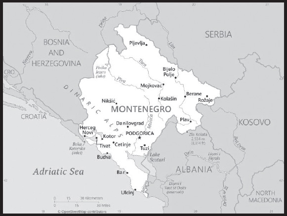
Location: Southeastern Europe, between the Adriatic Sea and Serbia
Geographic coordinates: 42 30 N, 19 18 E
Map references: Europe
Area: total: 13,812 sq km
land: 13,452 sq km
water: 360 sq km
comparison ranking: total 161
Area - comparative: slightly smaller than Connecticut; slightly larger than twice the size of Delaware
Land boundaries: total: 680 km
border countries (5): Albania 186 km; Bosnia and Herzegovina 242 km; Croatia 19 km; Kosovo 76 km; Serbia 157 km
Coastline: 293.5 km
Maritime claims: territorial sea: 12 nm
continental shelf: defined by treaty
Climate: Mediterranean climate, hot dry summers and autumns and relatively cold winters with heavy snowfalls inland
Terrain: highly indented coastline with narrow coastal plain backed by rugged high limestone mountains and plateaus
Elevation: highest point: Zia Kolata 2,534 m
lowest point: Adriatic Sea 0 m
mean elevation: 1,086 m
Natural resources: bauxite, hydroelectricity
Land use: agricultural land: 38.2% (2018 est.)
arable land: 12.9% (2018 est.)
permanent crops: 1.2% (2018 est.)
permanent pasture: 24.1% (2018 est.)
forest: 40.4% (2018 est.)
other: 21.4% (2018 est.)
Irrigated land: 24 sq km (2012)
Major lakes (area sq km): fresh water lake(s): Lake Scutari (shared with Albania) - 400 sq km
note - largest lake in the Balkans
Major watersheds (area sq km): Atlantic Ocean drainage: (Black Sea) Danube (795,656 sq km)
Population distribution: highest population density is concentrated in the south, southwest; the extreme eastern border is the least populated area
Natural hazards: destructive earthquakes
Geography - note: strategic location along the Adriatic coast
PEOPLE AND SOCIETY
Population: 602,445 (2023 est.)
comparison ranking: 172
Nationality: noun: Montenegrin(s)
adjective: Montenegrin
Ethnic groups: Montenegrin 45%, Serbian 28.7%, Bosniak 8.7%, Albanian 4.9%, Muslim 3.3%, Romani 1%, Croat 1%, other 2.6%, unspecified 4.9% (2011 est.)
Languages: Serbian 42.9%, Montenegrin (official) 37%, Bosnian 5.3%, Albanian 5.3%, Serbo-Croat 2%, other 3.5%, unspecified 4% (2011 est.)
major-language sample(s):
Knjiga svetskih činjenica, neophodan izvor osnovnih informacija. (Serbian)
Knjiga svjetskih činjenica, neophodan izvor osnovnih informacija. (Montenegrin/Bosnian)
Religions: Orthodox 72.1%, Muslim 19.1%, Catholic 3.4%, atheist 1.2%, other 1.5%, unspecified 2.6% (2011 est.)
Age structure: 0-14 years: 17.93% (male 55,690/female 52,340)
15-64 years: 64.65% (male 194,334/female 195,127)
65 years and over: 17.42% (2023 est.) (male 45,993/female 58,961)
Dependency ratios: total dependency ratio: 52.5
youth dependency ratio: 27.7
elderly dependency ratio: 24.8
potential support ratio: 4 (2021 est.)
Median age: total: 39.6 years (2020)
male: 38.1 years
female: 41.1 years
comparison ranking: total 54
Population growth rate: -0.43% (2023 est.)
comparison ranking: 221
Birth rate: 11.04 births/1,000 population (2023 est.)
comparison ranking: 165
Death rate: 10.3 deaths/1,000 population (2023 est.)
comparison ranking: 30
Net migration rate: -4.99 migrant(s)/1,000 population (2023 est.)
comparison ranking: 203
Population distribution: highest population density is concentrated in the south, southwest; the extreme eastern border is the least populated area
Urbanization: urban population: 68.5% of total population (2023)
rate of urbanization: 0.45% annual rate of change (2020-25 est.)
Major urban areas - population: 177,000 PODGORICA (capital) (2018)
Sex ratio: at birth: 1.04 male(s)/female
0-14 years: 1.06 male(s)/female
15-64 years: 1 male(s)/female
65 years and over: 0.78 male(s)/female
total population: 0.97 male(s)/female (2023 est.)
Mother’s mean age at first birth: 26.3 years (2010 est.)
Maternal mortality ratio: 6 deaths/100,000 live births (2020 est.)
comparison ranking: 161
Infant mortality rate: total: 3.2 deaths/1,000 live births (2023 est.)
male: 2.69 deaths/1,000 live births
female: 3.73 deaths/1,000 live births
comparison ranking: total 206
Life expectancy at birth: total population: 77.99 years (2023 est.)
male: 75.57 years
female: 80.5 years
comparison ranking: total population 86
Total fertility rate: 1.81 children born/woman (2023 est.)
comparison ranking: 142
Gross reproduction rate: 0.89 (2023 est.)
Contraceptive prevalence rate: 20.7% (2018)
Drinking water source: improved: urban: 100% of population
rural: 98.2% of population
total: 99.4% of population
unimproved: urban: 0% of population
rural: 1.8% of population
total: 0.6% of population (2020 est.)
Current health expenditure: 11.4% of GDP (2020)
Physicians density: 2.74 physicians/1,000 population (2020)
Hospital bed density: 3.9 beds/1,000 population (2017)
Sanitation facility access: improved: urban: 100% of population
rural: 93.9% of population
total: 98% of population
unimproved: urban: 0% of population
rural: 6.1% of population
total: 2% of population (2020 est.)
Major infectious diseases: degree of risk: intermediate (2023)
food or waterborne diseases: bacterial diarrhea
vectorborne diseases: Crimean-Congo hemorrhagic fever
Obesity - adult prevalence rate: 23.3% (2016)
comparison ranking: 66
Alcohol consumption per capita: total: 9.91 liters of pure alcohol (2019 est.)
beer: 3.83 liters of pure alcohol (2019 est.)
wine: 2.68 liters of pure alcohol (2019 est.)
spirits: 3.22 liters of pure alcohol (2019 est.)
other alcohols: 0.16 liters of pure alcohol (2019 est.)
comparison ranking: total 23
Tobacco use: total: 31.4% (2020 est.)
male: 31.6% (2020 est.)
female: 31.1% (2020 est.)
comparison ranking: total 26
Children under the age of 5 years underweight: 3.7% (2018/19)
comparison ranking: 82
Currently married women (ages 15-49): 57.1% (2023 est.)
Child marriage: women married by age 15: 1.9%
women married by age 18: 5.8%
men married by age 18: 3.2% (2018 est.)
Literacy: definition: age 15 and over can read and write
total population: 99%
male: 99.4%
female: 98.5% (2021)
School life expectancy (primary to tertiary education): total: 15 years
male: 15 years
female: 16 years (2021)
Youth unemployment rate (ages 15-24): total: 31.6% (2021 est.)
male: 28.3%
female: 36.7%
comparison ranking: total 33
ENVIRONMENT
Environment - current issues: pollution of coastal waters from sewage outlets, especially in tourist-related areas such as Kotor; serious air pollution in Podgorica, Pljevlja and Niksie; air pollution in Pljevlja is caused by the nearby lignite power plant and the domestic use of coal and wood for household heating
Environment - international agreements: party to: Air Pollution, Air Pollution-Heavy Metals, Air Pollution-Persistent Organic Pollutants, Biodiversity, Climate Change, Climate Change-Kyoto Protocol, Climate Change-Paris Agreement, Comprehensive Nuclear Test Ban, Desertification, Endangered Species, Hazardous Wastes, Law of the Sea, Marine Dumping-London Convention, Marine Life Conservation, Nuclear Test Ban, Ozone Layer Protection, Ship Pollution, Wetlands
signed, but not ratified: none of the selected agreements
Climate: Mediterranean climate, hot dry summers and autumns and relatively cold winters with heavy snowfalls inland
Land use: agricultural land: 38.2% (2018 est.)
arable land: 12.9% (2018 est.)
permanent crops: 1.2% (2018 est.)
permanent pasture: 24.1% (2018 est.)
forest: 40.4% (2018 est.)
other: 21.4% (2018 est.)
Urbanization: urban population: 68.5% of total population (2023)
rate of urbanization: 0.45% annual rate of change (2020-25 est.)
Revenue from forest resources: 0.43% of GDP (2018 est.)
comparison ranking: 70
Revenue from coal: 0.12% of GDP (2018 est.)
comparison ranking: 25
Air pollutants: particulate matter emissions: 19.3 micrograms per cubic meter (2019 est.)
carbon dioxide emissions: 2.02 megatons (2016 est.)
methane emissions: 0.75 megatons (2020 est.)
Waste and recycling: municipal solid waste generated annually: 332,000 tons (2015 est.)
municipal solid waste recycled annually: 17,994 tons (2015 est.)
percent of municipal solid waste recycled: 5.4% (2015 est.)
Major lakes (area sq km): fresh water lake(s): Lake Scutari (shared with Albania) - 400 sq km
note - largest lake in the Balkans
Major watersheds (area sq km): Atlantic Ocean drainage: (Black Sea) Danube (795,656 sq km)
Total water withdrawal: municipal: 100 million cubic meters (2020 est.)
industrial: 60 million cubic meters (2020 est.)
agricultural: 1.7 million cubic meters (2017 est.)
GOVERNMENT
Country name: conventional long form: none
conventional short form: Montenegro
local long form: none
local short form: Crna Gora
former: People’s Republic of Montenegro, Socialist Republic of Montenegro, Republic of Montenegro
etymology: the country’s name locally as well as in most Western European languages means “black mountain” and refers to the dark coniferous forests on Mount Lovcen and the surrounding area
Government type: parliamentary republic
Capital: name: Podgorica; note - Cetinje retains the status of “Old Royal Capital”
geographic coordinates: 42 26 N, 19 16 E
time difference: UTC+1 (6 hours ahead of Washington, DC, during Standard Time)
daylight saving time: +1 hr, begins last Sunday in March; ends last Sunday in October
etymology: the name translates as “beneath Gorica”; the meaning of Gorica is “hillock”; the reference is to the small hill named Gorica that the city is built around
Administrative divisions: 25 municipalities (opstine, singular - opstina); Andrijevica, Bar, Berane, Bijelo Polje, Budva, Cetinje, Danilovgrad, Gusinje, Herceg Novi, Kolasin, Kotor, Mojkovac, Niksic, Petnjica, Plav, Pljevlja, Pluzine, Podgorica, Rozaje, Savnik, Tivat, Tuzi, Ulcinj, Zabljak, Zeta
Independence: 3 June 2006 (from the State Union of Serbia and Montenegro); notable earlier dates: 13 March 1852 (Principality of Montenegro established); 13 July 1878 (Congress of Berlin recognizes Montenegrin independence); 28 August 1910 (Kingdom of Montenegro established)
National holiday: Statehood Day, 13 July (1878, the day the Berlin Congress recognized Montenegro as the 27th independent state in the world, and 1941, the day the Montenegrins staged an uprising against fascist occupiers and sided with the partisan communist movement)
Constitution: history: several previous; latest adopted 22 October 2007
amendments: proposed by the president of Montenegro, by the government, or by at least 25 members of the Assembly; passage of draft proposals requires two-thirds majority vote of the Assembly, followed by a public hearing; passage of draft amendments requires two-thirds majority vote of the Assembly; changes to certain constitutional articles, such as sovereignty, state symbols, citizenship, and constitutional change procedures, require three-fifths majority vote in a referendum; amended 2013
Legal system: civil law
International law organization participation: has not submitted an ICJ jurisdiction declaration; accepts ICCt jurisdiction
Citizenship: citizenship by birth: no
citizenship by descent only: at least one parent must be a citizen of Montenegro
dual citizenship recognized: no
residency requirement for naturalization: 10 years
Suffrage: 18 years of age; universal
Executive branch: chief of state: President Jakov MILATOVIC (since 20 May 2023)
head of government: Prime Minister Milojko SPAJIC (since 31 October 2023)
cabinet: ministers act as cabinet
elections/appointments: president directly elected by absolute majority popular vote in 2 rounds if needed for a 5-year term (eligible for a second term); election last held on 19 March 2023 with a runoff on 2 April 2023 (next to be held in 2028); prime minister nominated by the president, approved by the Assembly
election results:
2023: Jakov MILATOVIC elected president in second round; percent of vote in first round - Milo DUKANOVIC (DPS) 35.4%, Jakov MILATOVIC (Europe Now!) 28.9%, Andrija MANDIC (DF) 19.3%, Aleksa BECIC (DCG) 11.1%, other 5.3%; percent of vote in second round - Jakov MILATOVIC 58.9%, Milo DUKANOVIC 41.1%
2018: Milo DJUKANOVIC elected president in first round; percent of vote - Milo DJUKANOVIC (DPS) 53.9%, Mladen BOJANIC (independent) 33.4%, Draginja VUKSANOVIC (SDP) 8.2%, Marko MILACIC (PRAVA) 2.8%, other 1.7%
Legislative branch: description: unicameral Assembly or Skupstina (81 seats; members directly elected in a single nationwide constituency by proportional representation vote; members serve 4-year terms)
elections: last held on 11 June 2023 (next to be held in June 2027)
election results: percent of vote by party/coalition - Europe Now! 25.5%, Together! 23.2%, For the Future of Montenegro 14.7%, Aleksa and Dritan - Count Bravely 12.5%, BP 7.1%, SNP-DEMOS 3.1%, Albanian Forum 1.9%, HGI 0.7%; seats by party/coalition Europe Now! 24, Together! 21, For the Future of Montenegro 13, Aleksa and Dritan - Count Bravely 11, BP 6, SNP-DEMOS 2, Albanian Forum 2, Albanian Alliance 1, HGI 1; composition - as of October 2023 - men 64, women 17, percent of women 21%
Judicial branch: highest court(s): Supreme Court or Vrhovni Sud (consists of the court president, deputy president, and 15 judges); Constitutional Court or Ustavni Sud (consists of the court president and 7 judges)
judge selection and term of office: Supreme Court president proposed by general session of the Supreme Court and elected by the Judicial Council, a 9-member body consisting of judges, lawyers designated by the Assembly, and the minister of judicial affairs; Supreme Court president elected for a single renewable, 5-year term; other judges elected by the Judicial Council for life; Constitutional Court judges - 2 proposed by the president of Montenegro and 5 by the Assembly, and elected by the Assembly; court president elected from among the court members; court president elected for a 3-year term, other judges serve 9-year terms
subordinate courts: Administrative Courts; Appellate Court; Commercial Courts; High Courts; basic courts
Political parties and leaders: Albanian Alliance (electoral coalition includes FORCA, PD, DSCG)
Albanian Alternative or AA [Nik DELJOSAJ]
Albanian Democratic League or LDSH [Nicola CAMAJ]
Albanian Forum (electoral coalition includes AA, LDSH, UDSH)
Aleksa and Dritan - Count Bravely! [Aleksa BECIC] (electoral coalition includes Democrats, URA)
Bosniak Party or BS [Ervin IBRAHIMOVIC]
Civic Movement United Reform Action or United Reform Action or URA [Dritan ABAZOVIC]
Croatian Civic Initiative or HGI [Adrian VUKSANOVIC]
Democratic Alliance or DEMOS [Miodrag LEKIC]
Democratic League in Montenegro or DSCG [Mehmet BARDHI]
Democratic Montenegro or Democrats [Aleksa BECIC]
Democratic Party of Socialists or DPS [Danijel ZIVKOVIC, acting]
Democratic People’s Party or DNP [Milan KNEZEVIC]
Democratic Union of Albanians or UDSH [Mehmet ZENKA]
Europe Now! [Milojko SPAJIC]
For the Future of Montenegro or ZBCG [Milan KNEZEVIC] (coalition includes NSD, DNP, RP)
Liberal Party or LP [Andrija POPOVIC]
New Democratic Power or FORCA [Nazif CUNGU]
New Serb Democracy or NSD or NOVA [Andrija MANDIC]
Social Democrats or SD [Damir SEHOVIC]
Socialist People’s Party or SNP [Vladimir JOKOVIC]
Together! (electoral coalition includes DPS, SD, LP, UDSH)
United Montenegro or UCG [Goran DANILOVIC] (split from DEMOS)
Workers’ Party or RP [Maksim VUCINIC]
International organization participation: CE, CEI, EAPC, EBRD, FAO, IAEA, IBRD, ICAO, ICC (NGOs), ICCt, ICRM, IDA, IFC, IFRCS, IHO, ILO, IMF, IMO, IMSO, Interpol, IOC, IOM, IPU, ISO (correspondent), ITSO, ITU, ITUC (NGOs), MIGA, NATO, OAS (observer), OIF (observer), OPCW, OSCE, PCA, PFP, SELEC, UN, UNCTAD, UNESCO, UNHCR, UNHRC, UNIDO, UNWTO, UPU, WCO, WHO, WIPO, WMO, WTO
note: Montenegro is an EU candidate country whose satisfactory completion of accession criteria is required before being granted full EU membership
Diplomatic representation in the US: chief of mission: Ambassador (vacant); Chargé d’Affaires Nebojsa TODOROVIC (since 7 December 2022)
chancery: 1610 New Hampshire Avenue NW, Washington, DC, 20009
telephone: [1] (202) 234-6108
FAX: [1] (202) 234-6109
email address and website:
consulate(s) general: New York
Diplomatic representation from the US: chief of mission: Ambassador Judy Rising REINKE (since 20 December 2018)
embassy: Dzona Dzeksona 2, 81000 Podgorica
mailing address: 5570 Podgorica Place, Washington DC 20521-5570
telephone: +382 (0)20-410-500
FAX: [382] (0)20-241-358
email address and website:
Flag description: a red field bordered by a narrow golden-yellow stripe with the Montenegrin coat of arms centered; the arms consist of a double-headed golden eagle - symbolizing the unity of church and state - surmounted by a crown; the eagle holds a golden scepter in its right claw and a blue orb in its left; the breast shield over the eagle shows a golden lion passant on a green field in front of a blue sky; the lion is a symbol of episcopal authority and harkens back to the three and a half centuries when Montenegro was ruled as a theocracy
National symbol(s): double-headed eagle; national colors: red, gold
National anthem: name: “Oj, svijetla majska zoro” (Oh, Bright Dawn of May)
lyrics/music: Sekula DRLJEVIC/unknown, arranged by Zarko MIKOVIC
note: adopted 2004; music based on a Montenegrin folk song
National heritage: total World Heritage Sites: 4 (3 cultural, 1 natural)
selected World Heritage Site locales: Natural and Culturo-Historical Region of Kotor (c); Durmitor National Park (n); Stećci Medieval Tombstones Graveyards (c); Fortified City of Kotor Venetian Defense Works (c)
ECONOMY
Economic overview: upper middle-income Balkan economy; unsanctioned euro user; controversial religious property ownership law; persistent corruption; major infrastructure investments and high expenditures; growing offshore banking destination
Real GDP (purchasing power parity): $12.757 billion (2021 est.)
$11.346 billion (2020 est.)
$13.397 billion (2019 est.)
note: data are in 2017 dollars
comparison ranking: 159
Real GDP growth rate: 12.43% (2021 est.)
-15.31% (2020 est.)
4.06% (2019 est.)
comparison ranking: 16
Real GDP per capita: $20,600 (2021 est.)
$18,300 (2020 est.)
$21,500 (2019 est.)
note: data are in 2017 dollars
comparison ranking: 90
GDP (official exchange rate): $5.486 billion (2019 est.)
Inflation rate (consumer prices): 2.41% (2021 est.)
-0.26% (2020 est.)
0.36% (2019 est.)
comparison ranking: 140
Credit ratings: Moody’s rating: B1 (2016)
Standard & Poors rating: B+ (2014)
note: The year refers to the year in which the current credit rating was first obtained.
GDP - composition, by sector of origin: agriculture: 7.5% (2016 est.)
industry: 15.9% (2016 est.)
services: 76.6% (2016 est.)
comparison rankings: services 42; industry 175; agriculture 104
GDP - composition, by end use: household consumption: 76.8% (2016 est.)
government consumption: 19.6% (2016 est.)
investment in fixed capital: 23.2% (2016 est.)
investment in inventories: 2.9% (2016 est.)
exports of goods and services: 40.5% (2016 est.)
imports of goods and services: -63% (2016 est.)
Agricultural products: milk, potatoes, grapes, vegetables, tomatoes, watermelons, wheat, apples, cabbages, barley
Industries: steelmaking, aluminum, agricultural processing, consumer goods, tourism
Industrial production growth rate: 1.39% (2021 est.)
comparison ranking: 144
Labor force: 277,400 (2021 est.)
comparison ranking: 169
Labor force - by occupation: agriculture: 7.9%
industry: 17.1%
services: 75% (2017 est.)
Unemployment rate: 18.49% (2021 est.)
17.9% (2020 est.)
15.12% (2019 est.)
comparison ranking: 24
Youth unemployment rate (ages 15-24): total: 31.6% (2021 est.)
male: 28.3%
female: 36.7%
comparison ranking: total 33
Population below poverty line: 24.5% (2018 est.)
Gini Index coefficient - distribution of family income: 36.8 (2018 est.)
comparison ranking: 82
Average household expenditures: on food: 27.5% of household expenditures (2018 est.)
on alcohol and tobacco: 6.8% of household expenditures (2018 est.)
Household income or consumption by percentage share: lowest 10%: 3.5%
highest 10%: 25.7% (2014 est.)
Budget: revenues: $2.051 billion (2020 est.)
expenditures: $2.568 billion (2020 est.)
Budget surplus (+) or deficit (-): -5.6% (of GDP) (2017 est.)
comparison ranking: 176
Public debt: 67.2% of GDP (2017 est.)
66.4% of GDP (2016 est.)
note: data cover general government debt, and includes debt instruments issued (or owned) by government entities other than the treasury; the data include treasury debt held by foreign entities; the data include debt issued by subnational entities, as well as intragovernmental debt; intragovernmental debt consists of treasury borrowings from surpluses in the social funds, such as for retirement, medical care, and unemployment; debt instruments for the social funds are not sold at public auctions
comparison ranking: 64
Taxes and other revenues: 37.2% (of GDP) (2017 est.)
comparison ranking: 17
Fiscal year: calendar year
Current account balance: -$540.073 million (2021 est.)
-$1.237 billion (2020 est.)
-$796.134 million (2019 est.)
comparison ranking: 119
Exports: $2.502 billion (2021 est.) note: data are in current year dollars
$1.247 billion (2020 est.) note: data are in current year dollars
$2.424 billion (2019 est.) note: data are in current year dollars
comparison ranking: 152
Exports - partners: Serbia 17%, Hungary 15%, China 11%, Russia 7%, Bosnia and Herzegovina 6%, Germany 6%, Italy 5%, Poland 5% (2019)
Exports - commodities: copper ore, aluminum, electricity, dried legumes, packaged medicines, lead, scrap iron, lumber (2021)
Imports: $3.637 billion (2021 est.) note: data are in current year dollars
$2.917 billion (2020 est.) note: data are in current year dollars
$3.6 billion (2019 est.) note: data are in current year dollars
comparison ranking: 155
Imports - partners: Serbia 30%, Bosnia and Herzegovina 8%, Croatia 8%, Italy 6%, Greece 6%, Germany 5% (2019)
Imports - commodities: refined petroleum, cars, packaged medicines, recreational boats, cigarettes (2019)
Reserves of foreign exchange and gold: $1.982 billion (31 December 2021 est.)
$2.135 billion (31 December 2020 est.)
$1.529 billion (31 December 2019 est.)
comparison ranking: 131
Debt - external: $2.516 billion (31 December 2017 est.)
$2.224 billion (31 December 2016 est.)
comparison ranking: 148
Exchange rates: euros (EUR) per US dollar -
Exchange rates: 0.845 (2021 est.)
0.877 (2020 est.)
0.893 (2019 est.)
0.847 (2018 est.)
0.885 (2017 est.)
note: Montenegro, which is neither an EU member state nor a party to a formal EU monetary agreement, uses the euro as its de facto currency
ENERGY
Electricity access: electrification - total population: 99.7% (2021)
electrification - urban areas: 100% (2021)
electrification - rural areas: 99.3% (2021)
Electricity: installed generating capacity: 1.007 million kW (2020 est.)
consumption: 3,246,760,000 kWh (2019 est.)
exports: 943 million kWh (2019 est.)
imports: 1.196 billion kWh (2019 est.)
transmission/distribution losses: 493 million kWh (2019 est.)
comparison rankings: installed generating capacity 134; transmission/distribution losses 131; imports 69; exports 65; consumption 136
Electricity generation sources: fossil fuels: 42.3% of total installed capacity (2020 est.)
wind: 10.5% of total installed capacity (2020 est.)
hydroelectricity: 47.2% of total installed capacity (2020 est.)
Coal: production: 1.456 million metric tons (2020 est.)
consumption: 1.351 million metric tons (2020 est.)
exports: 96,000 metric tons (2020 est.)
imports: 1,000 metric tons (2020 est.)
proven reserves: 142 million metric tons (2019 est.)
Petroleum: total petroleum production: 0 bbl/day (2021 est.)
refined petroleum consumption: 7,600 bbl/day (2019 est.)
Refined petroleum products - exports: 357 bbl/day (2015 est.)
comparison ranking: 114
Refined petroleum products - imports: 6,448 bbl/day (2015 est.)
comparison ranking: 163
Carbon dioxide emissions: 2.447 million metric tonnes of CO2 (2019 est.)
from coal and metallurgical coke: 1.333 million metric tonnes of CO2 (2019 est.)
from petroleum and other liquids: 1.114 million metric tonnes of CO2 (2019 est.)
comparison ranking: total emissions 153
Energy consumption per capita: 77.286 million Btu/person (2019 est.)
comparison ranking: 78
COMMUNICATIONS
Telephones - fixed lines: total subscriptions: 189,519 (2021 est.)
subscriptions per 100 inhabitants: 30 (2021 est.)
comparison ranking: total subscriptions 124
Telephones - mobile cellular: total subscriptions: 1,120,074 (2021 est.)
subscriptions per 100 inhabitants: 178 (2021 est.)
comparison ranking: total subscriptions 162
Telecommunication systems: general assessment: a small telecom market supported by a population of only 623,000; fixed broadband services are available via a variety of technology platforms, though fiber is the dominant platform, accounting for almost 40% of connections; the growth of fiber has largely been at the expense of DSL as customers are migrated to fiber networks as these are built out progressively; mobile penetration is particularly high, though this is partly due to the significant number of tourists visiting the country seasonally, as also to the popularity of subscribers having multiple prepaid cards; in the wake of the pandemic and associated restrictions on travel, the number of mobile subscribers fell in 2020, as also in the first quarter of 2021, year-on-year; networks support a vibrant mobile broadband services sector, largely based on LTE; two of the MNOs began trialing 5G in May 2021, though commercial services will not gain traction until after the multispectrum auction is completed at the end of 2021; spectrum is available in the 694-790MHz and 3400-3800MHz ranges, as well as in the 26.5-27.5GHz range (2021)
domestic: fixed-line over 30 per 100 and mobile-cellular 178 per 100 persons (2021)
international: country code - 382; 2 international switches connect the national system
Broadcast media: state-funded national radio-TV broadcaster operates 2 terrestrial TV networks, 1 satellite TV channel, and 2 radio networks; 4 local public TV stations and 14 private TV stations; 14 local public radio stations, 35 private radio stations, and several on-line media (2019)
Internet country code: .me
Internet users: total: 516,600 (2021 est.)
percent of population: 82% (2021 est.)
comparison ranking: total 166
Broadband - fixed subscriptions: total: 184,176 (2020 est.)
subscriptions per 100 inhabitants: 29 (2020 est.)
comparison ranking: total 121
TRANSPORTATION
National air transport system: number of registered air carriers: 1 (2020)
inventory of registered aircraft operated by air carriers: 4
annual passenger traffic on registered air carriers: 565,522 (2018)
annual freight traffic on registered air carriers: 130,000 (2018) mt-km
Civil aircraft registration country code prefix: 4O
Airports: 5 (2021)
comparison ranking: total 182
Airports - with paved runways: 5
note: paved runways have a concrete or asphalt surface but not all have facilities for refueling, maintenance, or air traffic control; the length of a runway required for aircraft to safely operate depends on a number of factors including the type of aircraft, the takeoff weight (including passengers, cargo, and fuel), engine types, flap settings, landing speed, elevation of the airport, and average maximum daily air temperature; paved runways can reach a length of 5,000 m (16,000 ft.), but the “typical” length of a commercial airline runway is between 2,500-4,000 m (8,000-13,000 ft.)
Heliports: 1 (2021)
Railways: total: 250 km (2017)
standard gauge: 250 km (2017) 1.435-m gauge (224 km electrified)
comparison ranking: total 126
Roadways: total: 7,762 km (2010)
paved: 7,141 km (2010)
unpaved: 621 km (2010)
comparison ranking: total 139
Merchant marine: total: 18 (2022)
by type: bulk carrier 4, other 14
comparison ranking: total 149
Ports and terminals: major seaport(s): Bar
MILITARY AND SECURITY
Military and security forces: Army of Montenegro (Vojska Crne Gore or VCG): Ground Forces (Kopnene snage), Air Force (Vazduhoplovstvo), Navy (Mornarica) (2023)
note: the National Police Force, which includes Border Police, is responsible for maintaining internal security; it is organized under the Police Administration within the Ministry of Interior and reports to the police director and, through the director, to the minister of interior and prime minister
Military expenditures: 1.9% of GDP (2023 est.)
1.4% of GDP (2022 est.)
1.6% of GDP (2021)
1.7% of GDP (2020)
1.3% of GDP (2019)
comparison ranking: 63
Military and security service personnel strengths: approximately 2,000 active-duty troops (2023)
Military equipment inventories and acquisitions: the military’s inventory is small and consists mostly of Soviet-era equipment inherited from the former Yugoslavia military, with a limited mix of other imported systems from such countries as Austria, Turkey, and the US (2023)
Military service age and obligation: 18 is the legal minimum age for voluntary military service; conscription abolished in 2006 (2023)
note: as of 2023, women made up over 15% of the military’s full-time personnel
Military - note: the Army of Montenegro is a small military focused on the defense of Montenegro’s sovereignty and territorial integrity, cooperating in international and multinational security, and assisting civil authorities during emergencies such as natural disasters; since Montenegro joined NATO in 2017, another focus has been integrating into the Alliance, including adapting NATO standards for planning and professionalization, structural reforms, and modernization by replacing its Soviet-era equipment; the Army trains and exercises with NATO partners and actively supports NATO missions and operations, committing small numbers of troops in Afghanistan, Kosovo, and NATO’s Enhanced Forward Presence mission in Eastern Europe; a few personnel have also been deployed on EU- and UN-led operations
the combat units of the Ground Forces include an infantry battalion, plus artillery and special forces; there are two additional infantry battalions in reserve; the Air Force has ground air defense units but no combat aircraft; the Navy is a coastal defense force with a small inventory of coastal patrol craft and patrol boats, plus a marine/special forces detachment (2023)
TRANSNATIONAL ISSUES
Disputes - international: Montenegro-Albania: none identified
Montenegro-Bosnia and Herzegovina: the two countries signed a border agreement in August 2015; sovereignty of the disputed Sutorina territory was given to Montenegro
Montenegro-Croatia: the two countries in 2002 reached a temporary agreement designating the Prevlaka Peninsula as part of Croatia, in October 2020, a Montenegrin official resurrected the dormant dispute over the Prevlaka Peninsula by stating that Montenegro had a good chance of winning it through international arbitration
Montenegro-Kosovo: a 2015 border agreement was ratified by Montenegro in 2015 and by Kosovo in 2018, but the actual demarcation has not been completed
Montenegro-Serbia: The former republic boundary – when the two countries were one and called the Federal Republic of Yugoslavia – serves as the boundary until a line is formally delimited and demarcated
Refugees and internally displaced persons: refugees (country of origin): 63,345 (Ukraine) (as of 15 November 2023)
stateless persons: 468 (2022)
note: 33,825 estimated refugee and migrant arrivals (January 2015-November 2023)
Trafficking in persons: tier rating: Tier 2 Watch List — Montenegro does not fully meet the minimum standards for the elimination of trafficking but is making significant efforts to do so; the government prosecuted more defendants and identified more trafficking victims, adopted the National Action Plan for 2022, and coordinating bodies met consistently; however, the government did not demonstrate overall increasing efforts, compared with the previous reporting period, to expand its anti-trafficking capacity; officials did not convict any traffickers and reorganized the police office dedicated to investigating trafficking, reducing its ability to conduct proactive investigations; the government did not act quickly to protect victims after experts published credible allegations of abuse by an employee with management duties for the government-funded NGO-run anti-trafficking shelter, including physical violence, intimidation, and blackmail; although civil society and international organizations ceased victim referrals to the shelter, the government did not suspend its license and funding, continued to refer two child victims, and funded the shelter until the grant ended in December 2022; afterwards, Montenegro did not renew the shelter’s grant and decided to start renovating a government-run shelter for child trafficking victims; the government attempted to organize accommodations for child victims in foster families, but it did not develop a plan to provide protection for adult victims; therefore, Montenegro was downgraded to Tier 2 Watch List (2023)
trafficking profile: human traffickers exploit domestic and foreign victims in Montenegro, and Montenegrins abroad; traffickers are predominantly men between the ages of 25 and 49 and members of organized criminal groups that operate in the Western Balkans; victims in Montenegro are primarily women and girls from Montenegro, neighboring Balkan countries, and, to a lesser extent, other countries in Eastern Europe; traffickers exploit victims in the hospitality industry, including bars, restaurants, nightclubs, and cafes; children, particularly Romani, Ashkali, and Balkan Egyptian children, are forced to beg; Romani girls from Montenegro reportedly have been sold into marriages and forced into domestic servitude in Romani communities in Montenegro and, to a lesser extent, in Albania, Germany, and Kosovo; migrants from neighboring countries are vulnerable to forced labor, particularly during the summer tourism season; transnational organized criminal groups exploit some Montenegrin women and girls in sex trafficking in other Balkan countries (2023)
Illicit drugs: drug trafficking groups are major players in the procurement and transportation of of large quantities of cocaine destined for European markets
MONTSERRAT
INTRODUCTION
Background: English and Irish colonists from St. Kitts first settled on Montserrat in 1632; the first African slaves arrived three decades later. The British and French fought for possession of the island for most of the 18th century, but it finally was confirmed as a British possession in 1783. The island’s sugar plantation economy was converted to small farm landholdings in the mid-19th century. Much of this island was devastated and two thirds of the population fled abroad because of the eruption of the Soufriere Hills Volcano that began on 18 July 1995. Montserrat has endured volcanic activity since, with the last eruption occurring in 2013.
GEOGRAPHY
Location: Caribbean, island in the Caribbean Sea, southeast of Puerto Rico
Geographic coordinates: 16 45 N, 62 12 W
Map references: Central America and the Caribbean
Area: total: 102 sq km
land: 102 sq km
water: 0 sq km
comparison ranking: total 225
Area - comparative: about 0.6 times the size of Washington, DC
Land boundaries: total: 0 km
Coastline: 40 km
Maritime claims: territorial sea: 12 nm
exclusive fishing zone: 200 nm
Climate: tropical; little daily or seasonal temperature variation
Terrain: volcanic island, mostly mountainous, with small coastal lowland
Elevation: highest point: Soufriere Hills volcano pre-eruption height was 915 m; current lava dome is subject to periodic build up and collapse; estimated dome height was 1,050 m in 2015
lowest point: Caribbean Sea 0 m
Natural resources: NEGL
Land use: agricultural land: 30% (2018 est.)
arable land: 20% (2018 est.)
permanent crops: 0% (2018 est.)
permanent pasture: 10% (2018 est.)
forest: 25% (2018 est.)
other: 45% (2018 est.)
Irrigated land: 0 sq km (2022)
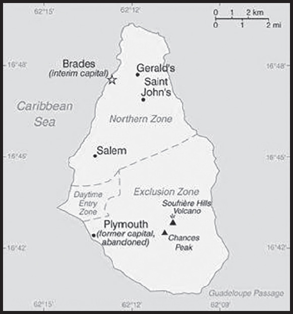
Population distribution: only the northern half of the island is populated, the southern portion is uninhabitable due to volcanic activity
Natural hazards: volcanic eruptions; severe hurricanes (June to November)
volcanism: Soufriere Hills volcano (915 m), has erupted continuously since 1995; a massive eruption in 1997 destroyed most of the capital, Plymouth, and resulted in approximately half of the island becoming uninhabitable; the island of Montserrat is part of the volcanic island arc of the Lesser Antilles that extends from Saba in the north to Grenada in the south
Geography - note: the island is entirely volcanic in origin and comprised of three major volcanic centers of differing ages
PEOPLE AND SOCIETY
Population: 5,440 (2023 est.)
note: an estimated 8,000 refugees left the island following the resumption of volcanic activity in July 1995; some have returned
comparison ranking: 226
Nationality: noun: Montserratian(s)
adjective: Montserratian
Ethnic groups: African/Black 86.2%, mixed 4.8%, Hispanic/Spanish 3%, Caucasian/White 2.7%, East Indian/Indian 1.6%, other 1.8% (2018 est.)
Languages: English
Religions: Protestant 71.4% (includes Anglican 17.7%, Pentecostal/Full Gospel 16.1%, Seventh Day Adventist 15%, Methodist 13.9%, Church of God 6.7%, other Protestant 2%), Roman Catholic 11.4%, Rastafarian 1.4%, Hindu 1.2%, Jehovah’s Witness 1%, Muslim 0.4%, other/not stated 5.1%, none 7.9% (2018 est.)
Age structure: 0-14 years: 15.92% (male 446/female 420)
15-64 years: 76.6% (male 2,051/female 2,116)
65 years and over: 7.48% (2023 est.) (male 217/female 190)
Dependency ratios: total dependency ratio: 43.9
youth dependency ratio: 19.2
elderly dependency ratio: 24.7
potential support ratio: 4 (2021)
Median age: total: 34.8 years (2020)
male: 34.1 years
female: 35.6 years
comparison ranking: total 88
Population growth rate: 0.46% (2023 est.)
comparison ranking: 155
Birth rate: 10.66 births/1,000 population (2023 est.)
comparison ranking: 177
Death rate: 6.07 deaths/1,000 population (2023 est.)
comparison ranking: 153
Net migration rate: 0 migrant(s)/1,000 population (2023 est.)
comparison ranking: 86
Population distribution: only the northern half of the island is populated, the southern portion is uninhabitable due to volcanic activity
Urbanization: urban population: 9.3% of total population (2023)
rate of urbanization: 0.94% annual rate of change (2020-25 est.)
Sex ratio: at birth: 1.07 male(s)/female
0-14 years: 1.06 male(s)/female
15-64 years: 0.97 male(s)/female
65 years and over: 1.14 male(s)/female
total population: 1 male(s)/female (2023 est.)
Infant mortality rate: total: 10.04 deaths/1,000 live births (2023 est.)
male: 8.16 deaths/1,000 live births
female: 12.01 deaths/1,000 live births
comparison ranking: total 135
Life expectancy at birth: total population: 75.91 years (2023 est.)
male: 76.79 years
female: 74.99 years
comparison ranking: total population 119
Total fertility rate: 1.32 children born/woman (2023 est.)
comparison ranking: 219
Gross reproduction rate: 0.64 (2023 est.)
Drinking water source: improved:
total: 98.1% of population
unimproved: total: 1.9% of population (2020 est.)
Currently married women (ages 15-49): 35.8% (2023 est.)
Education expenditures: 5.4% of GDP (2020 est.)
comparison ranking: 62
School life expectancy (primary to tertiary education): total: 14 years
male: 13 years
female: 15 years (2019)
ENVIRONMENT
Environment - current issues: land erosion occurs on slopes that have been cleared for cultivation
Climate: tropical; little daily or seasonal temperature variation
Land use: agricultural land: 30% (2018 est.)
arable land: 20% (2018 est.)
permanent crops: 0% (2018 est.)
permanent pasture: 10% (2018 est.)
forest: 25% (2018 est.)
other: 45% (2018 est.)
Urbanization: urban population: 9.3% of total population (2023)
rate of urbanization: 0.94% annual rate of change (2020-25 est.)
GOVERNMENT
Country name: conventional long form: none
conventional short form: Montserrat
etymology: island named by explorer Christopher COLUMBUS in 1493 after the Benedictine abbey Santa Maria de Montserrat, near Barcelona, Spain
Government type: parliamentary democracy; self-governing overseas territory of the UK
Dependency status: overseas territory of the UK
Capital: name: Plymouth; note - Plymouth was abandoned in 1997 because of volcanic activity; interim government buildings have been built at Brades Estate, the de facto capital, in the Carr’s Bay/Little Bay vicinity at the northwest end of Montserrat
geographic coordinates: 16 42 N, 62 13 W
time difference: UTC-4 (1 hour ahead of Washington, DC, during Standard Time)
etymology: now entirely deserted because of volcanic activity, the city was originally named after Plymouth, England; de jure, Plymouth remains the capital city of Montserrat; it is therefore the only ghost town that serves as the capital of a political entity
Administrative divisions: 3 parishes; Saint Anthony, Saint Georges, Saint Peter
Independence: none (overseas territory of the UK)
National holiday: Birthday of Queen ELIZABETH II, usually celebrated the Monday after the second Saturday in June (1926)
Constitution: history: previous 1960; latest put into force 20 October 2010 (The Montserrat Constitution Order 2010)
amendments: amended 2011, 2020
Legal system: English common law
Citizenship: see United Kingdom
Suffrage: 18 years of age; universal
Executive branch: chief of state: King CHARLES III (since 8 September 2022); represented by Governor Sarah TUCKER (since 6 April 2023)
head of government: Premier Easton TAYLOR-FARRELL (since 19 November 2019); note - effective with Constitution Order 2010, October 2010, the office of premier replaced the office of chief minister
cabinet: Executive Council consists of the governor, the premier, 3 other ministers, the attorney general, and the finance secretary
elections/appointments: the monarchy is hereditary; governor appointed by the monarch; following legislative elections, the leader of the majority party usually becomes premier
Legislative branch: description: unicameral Legislative Assembly (12 seats; 9 members directly elected in a single constituency by absolute majority vote in 2 rounds to serve 5-year terms; the speaker, normally elected from the outside by the Assembly for a 5-year term, and 2 ex-officio members - the attorney general and financial secretary)
elections: last held on 18 November 2019 (next to be held in 2024)
election results: percent of vote by party - MCAP 42.7%, PDM 29.9%, other 17.1%; seats by party - MCAP 5, PDM 3, independent 1; composition, including the speaker and 2 ex-officio members - men 8, women 4, percent of women 33.3%
Judicial branch: highest court(s): the Eastern Caribbean Supreme Court (ECSC) is the superior court of the Organization of Eastern Caribbean States; the ECSC - headquartered on St. Lucia - consists of the Court of Appeal - headed by the chief justice and 4 judges - and the High Court with 18 judges; the Court of Appeal is itinerant, traveling to member states on a schedule to hear appeals from the High Court and subordinate courts; High Court judges reside in the member states, with 1 assigned to Montserrat; Montserrat is also a member of the Caribbean Court of Justice
judge selection and term of office: chief justice of Eastern Caribbean Supreme Court appointed by the Her Majesty, Queen ELIZABETH II; other justices and judges appointed by the Judicial and Legal Services Commission, and independent body of judicial officials; Court of Appeal justices appointed for life with mandatory retirement at age 65; High Court judges appointed for life with mandatory retirement at age 62
subordinate courts: magistrate’s court
Political parties and leaders: Movement for Change and Prosperity or MCAP [Easton Taylor FARRELL]
People’s Democratic Movement or PDM [Paul LEWIS]
International organization participation: Caricom, CDB, Interpol (subbureau), OECS, UPU
Diplomatic representation in the US: none (overseas territory of the UK)
Diplomatic representation from the US: embassy: none (overseas territory of the UK); alternate contact is the US Embassy in Barbados [1] (246) 227-4000; US Embassy Bridgetown, Wildey Business Park, St. Michael BB 14006, Barbados, WI
Flag description: blue with the flag of the UK in the upper hoist-side quadrant and the Montserratian coat of arms centered in the outer half of the flag; the arms feature a woman in green dress, Erin, the female personification of Ireland, standing beside a yellow harp and embracing a large dark cross with her right arm; Erin and the harp are symbols of Ireland reflecting the territory’s Irish ancestry; blue represents awareness, trustworthiness, determination, and righteousness
National anthem: note: as a territory of the UK, “God Save the King” is official (see United Kingdom)
ECONOMY
Economic overview: formerly high-income economy; volcanic activity destroyed much of original infrastructure and economy; new capital and port is being developed; key geothermal and solar power generation; key music recording operations
Real GDP (purchasing power parity): $167.4 million (2011 est.)
$155.9 million (2010 est.)
$162.7 million (2009 est.)
comparison ranking: 223
Real GDP growth rate: 7.4% (2011 est.)
-4.2% (2010 est.)
comparison ranking: 52
Real GDP per capita: $34,000 (2011 est.)
$31,100 (2010 est.)
$32,300 (2009 est.)
comparison ranking: 62
GDP (official exchange rate): $167.4 million (2011 est.)
Inflation rate (consumer prices): 1.2% (2017 est.)
-0.2% (2016 est.)
comparison ranking: 194
Credit ratings: Standard & Poors rating: BBB- (2020)
note: The year refers to the year in which the current credit rating was first obtained.
GDP - composition, by sector of origin: agriculture: 1.9% (2017 est.)
industry: 7.8% (2017 est.)
services: 90.3% (2017 est.)
comparison rankings: services 9; industry 210; agriculture 177
GDP - composition, by end use: household consumption: 90.8% (2017 est.)
government consumption: 50.4% (2017 est.)
investment in fixed capital: 17.9% (2017 est.)
investment in inventories: -0.1% (2017 est.)
exports of goods and services: 29.5% (2017 est.)
imports of goods and services: -88.6% (2017 est.)
Agricultural products: cabbages, carrots, cucumbers, tomatoes, onions, peppers; livestock products
Industries: tourism, rum, textiles, electronic appliances
Industrial production growth rate: -21% (2017 est.)
comparison ranking: 206
Labor force: 4,521 (2012)
comparison ranking: 222
Labor force - by occupation: agriculture: 1.4%
industry: 12.7%
services: 85.9% (2017 est.)
Unemployment rate: 5.6% (2017 est.)
6% (1998 est.)
comparison ranking: 133
Budget: revenues: $66.67 million (2017 est.)
expenditures: $47.04 million (2017 est.)
Fiscal year: 1 April - 31 March
Current account balance: -$15.4 million (2017 est.)
-$12.2 million (2016 est.)
comparison ranking: 82
Exports: $11.9 million (2021 est.)
$4.4 million (2017 est.)
$5.2 million (2016 est.)
comparison ranking: 218
Exports - partners: Canada 48%, United States 14%, Belgium 14%, France 11%, Cost Rica 3% (2021)
Exports - commodities: iron products, needles and catheters, sand, dental filling pharmaceuticals, gravel (2021)
Imports: $15.3 million (2021 est.)
$39.44 million (2017 est.)
$36.1 million (2016 est.)
comparison ranking: 224
Imports - partners: United States 47%, Trinidad and Tobago 19%, United Kingdom 9%, Barbados 3%, Japan 2% (2021)
Imports - commodities: refined petroleum, food preparations, cars, broadcasting equipment, poultry (2021)
Reserves of foreign exchange and gold: $47.58 million (31 December 2017 est.)
$51.47 million (31 December 2015 est.)
comparison ranking: 192
Debt - external: $8.9 million (1997)
comparison ranking: 200
Exchange rates: East Caribbean dollars (XCD) per US dollar -
Exchange rates: 2.7 (2017 est.)
2.7 (2016 est.)
2.7 (2015 est.)
2.7 (2014 est.)
2.7 (2013 est.)
ENERGY
Electricity access: electrification - total population: 100% (2020)
Electricity: installed generating capacity: 5,000 kW (2020 est.)
consumption: 21.56 million kWh (2019 est.)
exports: 0 kWh (2020 est.)
imports: 0 kWh (2020 est.)
transmission/distribution losses: 1 million kWh (2019 est.)
comparison rankings: imports 127; exports 107; installed generating capacity 210; transmission/distribution losses 207; consumption 206
Electricity generation sources: fossil fuels: 100% of total installed capacity (2020 est.)
Petroleum: total petroleum production: 0 bbl/day (2021 est.)
refined petroleum consumption: 200 bbl/day (2019 est.)
Refined petroleum products - imports: 406 bbl/day (2015 est.)
comparison ranking: 207
Carbon dioxide emissions: 33,000 metric tonnes of CO2 (2019 est.)
from petroleum and other liquids: 33,000 metric tonnes of CO2 (2019 est.)
comparison ranking: total emissions 213
Energy consumption per capita: 0 Btu/person (2019 est.)
comparison ranking: 198
COMMUNICATIONS
Telephones - fixed lines: total subscriptions: 3,000 (2020 est.)
subscriptions per 100 inhabitants: 67 (2020 est.)
comparison ranking: total subscriptions 212
Telephones - mobile cellular: total subscriptions: 5,000 (2020 est.)
subscriptions per 100 inhabitants: 110 (2020 est.)
comparison ranking: total subscriptions 222
Telecommunication systems: general assessment: telecom market one of growth in Caribbean and fully digitalized; high dependency on tourism and offshore financial services; operators expand FttP (Fiber to Home) services; LTE launches and operators invest in mobile networks; effective competition in all sectors (2020)
domestic: fixed-line is 67 per 100 and mobile-cellular teledensity is 110 per 100 persons (2020)
international: country code - 1-664; landing point for the ECFS optic submarine cable with links to 14 other islands in the eastern Caribbean extending from the British Virgin Islands to Trinidad (2019)
Broadcast media: Radio Montserrat, a public radio broadcaster, transmits on 1 station and has a repeater transmission to a second station; repeater transmissions from the GEM Radio Network of Trinidad and Tobago provide another 2 radio stations; cable and satellite TV available (2007)
Internet country code: .ms
Internet users: total: 2,473 (2021 est.)
percent of population: 56.2% (2021 est.)
comparison ranking: total 226
Broadband - fixed subscriptions: total: 2,700 (2018 est.)
subscriptions per 100 inhabitants: 55 (2018 est.)
comparison ranking: total 196
TRANSPORTATION
National air transport system: number of registered air carriers: 1 (2020)
inventory of registered aircraft operated by air carriers: 3
Civil aircraft registration country code prefix: VP-M
Airports: 1 (2021)
comparison ranking: total 218
Airports - with paved runways: 1
note: paved runways have a concrete or asphalt surface but not all have facilities for refueling, maintenance, or air traffic control; the length of a runway required for aircraft to safely operate depends on a number of factors including the type of aircraft, the takeoff weight (including passengers, cargo, and fuel), engine types, flap settings, landing speed, elevation of the airport, and average maximum daily air temperature; paved runways can reach a length of 5,000 m (16,000 ft.), but the “typical” length of a commercial airline runway is between 2,500-4,000 m (8,000-13,000 ft.)
Roadways: note: volcanic eruptions that began in 1995 destroyed most of the 227 km road system; a new road infrastructure has been built on the north end of the island
Ports and terminals: major seaport(s): Little Bay, Plymouth
MILITARY AND SECURITY
Military and security forces: no regular military forces; Royal Montserrat Defense Force (ceremonial, civil defense duties), Montserrat Police Force
Military - note: defense is the responsibility of the UK
TRANSNATIONAL ISSUES
Disputes - international: none identified
Illicit drugs: transshipment point for South American narcotics destined for the US and Europe
MOROCCO
INTRODUCTION
Background: In 788, about a century after the Arab conquest of North Africa, a series of Moroccan Muslim dynasties began to rule in Morocco. In the 16th century, the Sa’adi monarchy, particularly under Ahmad al-MANSUR (1578-1603), repelled foreign invaders and inaugurated a golden age. The Alaouite Dynasty, to which the current Moroccan royal family belongs, dates from the 17th century. In 1860, Spain occupied northern Morocco and ushered in a half-century of trade rivalry among European powers that saw Morocco’s sovereignty steadily erode; in 1912, the French imposed a protectorate over the country. A protracted independence struggle with France ended successfully in 1956. The internationalized city of Tangier and most Spanish possessions were turned over to the new country that same year. Sultan MOHAMMED V, the current monarch’s grandfather, organized the new state as a constitutional monarchy and in 1957 assumed the title of king. Since Spain’s 1976 withdrawal from Western Sahara, Morocco has extended its de facto administrative control to roughly 75% of this territory; however, the UN does not recognize Morocco as the administering power for Western Sahara. The UN since 1991 has monitored a cease-fire, which broke down in late 2020, between Morocco and the Polisario Front - an organization advocating the territory’s independence - and restarted negotiations over the status of the territory in December 2018. On 10 December 2020, the US recognized Morocco’s sovereignty over all of Western Sahara.
King MOHAMMED VI in early 2011 responded to the spread of pro-democracy protests in the North Africa region by implementing a reform program that included a new constitution, passed by popular referendum in July 2011, under which some new powers were extended to parliament and the prime minister, but ultimate authority remains in the hands of the monarch. In November 2011, the Justice and Development Party (PJD) - a moderate Islamist party - won the largest number of seats in parliamentary elections, becoming the first Islamist party to lead the Moroccan Government. In September 2015, Morocco held its first direct elections for regional councils, one of the reforms included in the 2011 constitution. The PJD again won the largest number of seats in nationwide parliamentary elections in October 2016, but it lost its plurality to the probusiness National Rally of Independents (RNI) in September 2021. In December 2020, Morocco signed a normalization agreement with Israel, similar to those that Bahrain, the United Arab Emirates, and Sudan had concluded with Israel earlier in 2020.
GEOGRAPHY
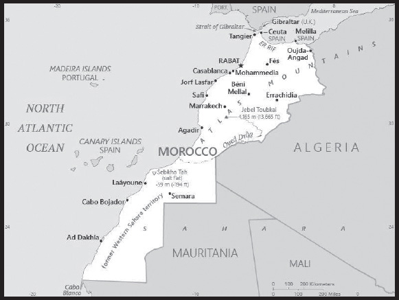
Location: Northern Africa, bordering the North Atlantic Ocean and the Mediterranean Sea, between Algeria and Mauritania
Geographic coordinates: 28 30 N, 10 00 W
Map references: Africa
Area: total: 716,550 sq km
land: 716,300 sq km
water: 250 sq km
comparison ranking: total 41
Area - comparative: slightly larger than twice the size of California
Land boundaries: total: 3,523.5 km
border countries (3): Algeria 1,941 km; Mauritania 1,564 km; Spain (Ceuta) 8 km and Spain (Melilla) 10.5 km
note: an additional 75-meter border segment exists between Morocco and the Spanish exclave of Penon de Velez de la Gomera
Coastline: 2,945 km
Maritime claims: territorial sea: 12 nm
contiguous zone: 24 nm
exclusive economic zone: 200 nm
continental shelf: 200-m depth or to the depth of exploitation
Climate: Mediterranean in the north, becoming more extreme in the interior; in the south, hot, dry desert; rain is rare; cold offshore air currents produce fog and heavy dew
note: data does not include former Western Sahara
Terrain: mountainous northern coast (Rif Mountains) and interior (Atlas Mountains) bordered by large plateaus with intermontane valleys, and fertile coastal plains; the south is mostly low, flat desert with large areas of rocky or sandy surfaces
Elevation: highest point: Jebel Toubkal 4,165 m
lowest point: Sebkha Tah -59 m
mean elevation: 909 m
Natural resources: phosphates, iron ore, manganese, lead, zinc, fish, salt
Land use: agricultural land: 67.5% (2018 est.)
arable land: 17.5% (2018 est.)
permanent crops: 2.9% (2018 est.)
permanent pasture: 47.1% (2018 est.)
forest: 11.5% (2018 est.)
other: 21% (2018 est.)
note: does not include the area of the former Western Sahara, which is almost exclusively desert
Irrigated land: 17,645 sq km (2019)
Major rivers (by length in km): Draa - 1,100 km
Population distribution: the highest population density is found along the Atlantic and Mediterranean coasts; a number of densely populated agglomerations are found scattered through the Atlas Mountains as shown in this population distribution map
Natural hazards: in the north, the mountains are geologically unstable and subject to earthquakes; periodic droughts; windstorms; flash floods; landslides; in the south, a hot, dry, dust/sand-laden sirocco wind can occur during winter and spring; widespread harmattan haze exists 60% of time, often severely restricting visibility
Geography - note: strategic location along Strait of Gibraltar; the only African nation to have both Atlantic and Mediterranean coastlines; the waters off the Atlantic coast are particularly rich fishing areas
PEOPLE AND SOCIETY
Population: 37,067,420 (2023 est.)
note: includes Western Sahara
comparison ranking: 40
Nationality: noun: Moroccan(s)
adjective: Moroccan
Ethnic groups: Arab-Berber 99%, other 1%
note: does not include data from the former Western Sahara
Languages: Arabic (official), Berber languages (Tamazight (official), Tachelhit, Tarifit), French (often the language of business, government, and diplomacy); note - the proportion of Berber speakers is disputed
major-language sample(s):
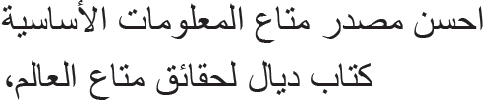
(Arabic)
Religions: Muslim 99% (official; virtually all Sunni, <0.1% Shia), other 1% (includes Christian, Jewish, and Baha’i); note - Jewish about 3,000-3,500 (2020 est.)
note: does not include data from the former Western Sahara
Demographic profile: Morocco is undergoing a demographic transition. Its population is growing but at a declining rate, as people live longer and women have fewer children. Infant, child, and maternal mortality rates have been reduced through better health care, nutrition, hygiene, and vaccination coverage, although disparities between urban and rural and rich and poor households persist. Morocco’s shrinking child cohort reflects the decline of its total fertility rate from 5 in mid-1980s to 2.2 in 2010, which is a result of increased female educational attainment, higher contraceptive use, delayed marriage, and the desire for smaller families. Young adults (persons aged 15-29) make up almost 26% of the total population and represent a potential economic asset if they can be gainfully employed. Currently, however, many youths are unemployed because Morocco’s job creation rate has not kept pace with the growth of its working-age population. Most youths who have jobs work in the informal sector with little security or benefits.
During the second half of the 20th century, Morocco became one of the world’s top emigration countries, creating large, widely dispersed migrant communities in Western Europe. The Moroccan Government has encouraged emigration since its independence in 1956, both to secure remittances for funding national development and as an outlet to prevent unrest in rebellious (often Berber) areas. Although Moroccan labor migrants earlier targeted Algeria and France, the flood of Moroccan “guest workers” from the mid-1960s to the early 1970s spread widely across northwestern Europe to fill unskilled jobs in the booming manufacturing, mining, construction, and agriculture industries. Host societies and most Moroccan migrants expected this migration to be temporary, but deteriorating economic conditions in Morocco related to the 1973 oil crisis and tighter European immigration policies resulted in these stays becoming permanent.
A wave of family migration followed in the 1970s and 1980s, with a growing number of second generation Moroccans opting to become naturalized citizens of their host countries. Spain and Italy emerged as new destination countries in the mid-1980s, but their introduction of visa restrictions in the early 1990s pushed Moroccans increasingly to migrate either legally by marrying Moroccans already in Europe or illegally to work in the underground economy. Women began to make up a growing share of these labor migrants. At the same time, some higher-skilled Moroccans went to the US and Quebec, Canada.
In the mid-1990s, Morocco developed into a transit country for asylum seekers from Sub-Saharan Africa and illegal labor migrants from Sub-Saharan Africa and South Asia trying to reach Europe via southern Spain, Spain’s Canary Islands, or Spain’s North African enclaves, Ceuta and Melilla. Forcible expulsions by Moroccan and Spanish security forces have not deterred these illegal migrants or calmed Europe’s security concerns. Rabat remains unlikely to adopt an EU agreement to take back third-country nationals who have entered the EU illegally via Morocco. Thousands of other illegal migrants have chosen to stay in Morocco until they earn enough money for further travel or permanently as a “second-best” option. The launching of a regularization program in 2014 legalized the status of some migrants and granted them equal access to education, health care, and work, but xenophobia and racism remain obstacles.
Age structure: 0-14 years: 26.01% (male 4,919,266/female 4,722,463)
15-64 years: 65.92% (male 12,124,939/female 12,311,552)
65 years and over: 8.06% (2023 est.) (male 1,455,355/female 1,533,845)
note: does not include data from the former Western Sahara
Dependency ratios: total dependency ratio: 52.2
youth dependency ratio: 40.9
elderly dependency ratio: 11.3
potential support ratio: 8.9 (2021 est.)
note: does not include data from the former Western Sahara
Median age: total: 29.1 years (2020)
male: 28.7 years
female: 29.6 years
note: does not include data from the former Western Sahara
comparison ranking: total 138
Population growth rate: 0.88% (2023 est.)
note: does not include data from the former Western Sahara
comparison ranking: 106
Birth rate: 17.1 births/1,000 population (2023 est.)
note: does not include data from the former Western Sahara
comparison ranking: 90
Death rate: 6.61 deaths/1,000 population (2023 est.)
note: does not include data from the former Western Sahara
comparison ranking: 130
Net migration rate: -1.73 migrant(s)/1,000 population (2023 est.)
note: does not include data from the former Western Sahara
comparison ranking: 166
Population distribution: the highest population density is found along the Atlantic and Mediterranean coasts; a number of densely populated agglomerations are found scattered through the Atlas Mountains as shown in this population distribution map
Urbanization: urban population: 65.1% of total population (2023)
rate of urbanization: 1.88% annual rate of change (2020-25 est.)
note: data does not include former Western Sahara
Major urban areas - population: 3.893 million Casablanca, 1.959 million RABAT (capital), 1.290 million Fes, 1.314 million Tangier, 1.050 million Marrakech, 979,000 Agadir (2023)
Sex ratio: at birth: 1.05 male(s)/female
0-14 years: 1.04 male(s)/female
15-64 years: 0.98 male(s)/female
65 years and over: 0.95 male(s)/female
total population: 1 male(s)/female (2023 est.)
note: does not include data from the former Western Sahara
Maternal mortality ratio: 72 deaths/100,000 live births (2020 est.)
note: does not include data from the former Western Sahara
comparison ranking: 83
Infant mortality rate: total: 18.73 deaths/1,000 live births (2023 est.)
male: 20.94 deaths/1,000 live births
female: 16.41 deaths/1,000 live births
note: does not include data from the former Western Sahara
comparison ranking: total 86
Life expectancy at birth: total population: 73.95 years (2023 est.)
male: 72.26 years
female: 75.72 years
note: does not include data from the former Western Sahara
comparison ranking: total population 146
Total fertility rate: 2.27 children born/woman (2023 est.)
note: does not include data from the former Western Sahara
comparison ranking: 78
Gross reproduction rate: 1.11 (2023 est.)
Contraceptive prevalence rate: 70.8% (2018)
note: does not include data from the former Western Sahara
Drinking water source: improved: urban: 98.3% of population
rural: 79.1% of population
total: 91% of population
unimproved: urban: 1.7% of population
rural: 20.9% of population
total: 9% of population (2017 est.)
note: does not include data from the former Western Sahara
Current health expenditure: 6% of GDP (2020)
note: does not include data from the former Western Sahara
Physicians density: 0.73 physicians/1,000 population (2017)
note: does not include data from the former Western Sahara
Hospital bed density: 1 beds/1,000 population (2017)
note: does not include data from the former Western Sahara
Sanitation facility access: improved: urban: 98.2% of population
rural: 72.4% of population
total: 88.8% of population
unimproved: urban: 1.8% of population
rural: 27.6% of population
total: 11.2% of population (2020 est.)
note: does not include data from the former Western Sahara
Obesity - adult prevalence rate: 26.1% (2016)
note: does not include data from the former Western Sahara
comparison ranking: 44
Alcohol consumption per capita: total: 0.51 liters of pure alcohol (2019 est.)
beer: 0.18 liters of pure alcohol (2019 est.)
wine: 0.24 liters of pure alcohol (2019 est.)
spirits: 0.09 liters of pure alcohol (2019 est.)
other alcohols: 0 liters of pure alcohol (2019 est.)
comparison ranking: total 163
Tobacco use: total: 14.5% (2020 est.)
male: 28.2% (2020 est.)
female: 0.8% (2020 est.)
comparison ranking: total 106
Children under the age of 5 years underweight: 2.8% (2019/20)
note: does not include data from the former Western Sahara
comparison ranking: 92
Currently married women (ages 15-49): 58.8% (2023 est.)
Child marriage: women married by age 15: 0.5%
women married by age 18: 13.7% (2018 est.)
Education expenditures: 6.8% of GDP (2020)
note: does not include data from the former Western Sahara
comparison ranking: 23
Literacy: definition: age 15 and over can read and write
total population: 75.9%
male: 84.8%
female: 67.4% (2021)
note: does not include data from the former Western Sahara
School life expectancy (primary to tertiary education): total: 14 years
male: 14 years
female: 14 years (2021)
note: does not include data from the former Western Sahara
Youth unemployment rate (ages 15-24): total: 27.2% (2021 est.)
male: 26.7%
female: 28.7%
note: does not include data from the former Western Sahara
comparison ranking: total 49
ENVIRONMENT
Environment - current issues: in the north, land degradation/desertification (soil erosion resulting from farming of marginal areas, overgrazing, destruction of vegetation); water and soil pollution due to dumping of industrial wastes into the ocean and inland water sources, and onto the land; in the south, desertification; overgrazing; sparse water and lack of arable land
note: data does not include former Western Sahara
Environment - international agreements: party to: Biodiversity, Climate Change, Climate Change-Kyoto Protocol, Climate Change-Paris Agreement, Comprehensive Nuclear Test Ban, Desertification, Endangered Species, Hazardous Wastes, Law of the Sea, Marine Dumping-London Convention, Marine Dumping-London Protocol, Nuclear Test Ban, Ozone Layer Protection, Ship Pollution, Wetlands, Whaling
signed, but not ratified: Environmental Modification
Climate: Mediterranean in the north, becoming more extreme in the interior; in the south, hot, dry desert; rain is rare; cold offshore air currents produce fog and heavy dew
note: data does not include former Western Sahara
Land use: agricultural land: 67.5% (2018 est.)
arable land: 17.5% (2018 est.)
permanent crops: 2.9% (2018 est.)
permanent pasture: 47.1% (2018 est.)
forest: 11.5% (2018 est.)
other: 21% (2018 est.)
note: does not include the area of the former Western Sahara, which is almost exclusively desert
Urbanization: urban population: 65.1% of total population (2023)
rate of urbanization: 1.88% annual rate of change (2020-25 est.)
note: data does not include former Western Sahara
Revenue from forest resources: 0.13% of GDP (2018 est.)
comparison ranking: 107
Revenue from coal: 0% of GDP (2018 est.)
comparison ranking: 80
Air pollutants: particulate matter emissions: 13.44 micrograms per cubic meter (2019 est.)
carbon dioxide emissions: 61.28 megatons (2016 est.)
methane emissions: 17.16 megatons (2020 est.)
note: data does not include former Western Sahara
Waste and recycling: municipal solid waste generated annually: 6.852 million tons (2014 est.)
municipal solid waste recycled annually: 548,160 tons (2014 est.)
percent of municipal solid waste recycled: 8% (2014 est.)
note: data does not include former Western Sahara
Major rivers (by length in km): Draa - 1,100 km
Total water withdrawal: municipal: 1.06 billion cubic meters (2020 est.)
industrial: 210 million cubic meters (2020 est.)
agricultural: 9.16 billion cubic meters (2020 est.)
note: data does not include former Western Sahara
Total renewable water resources: 29 billion cubic meters (2020 est.)
note: data does not include former Western Sahara
GOVERNMENT
Country name: conventional long form: Kingdom of Morocco
conventional short form: Morocco
local long form: Al Mamlakah al Maghribiyah
local short form: Al Maghrib
former: French Protectorate in Morocco, Spanish Protectorate in Morocco, Ifni, Spanish Sahara, Western Sahara
etymology: the English name “Morocco” derives from, respectively, the Spanish and Portuguese names “Marruecos” and “Marrocos,” which stem from “Marrakesh” the Latin name for the former capital of ancient Morocco; the Arabic name “Al Maghrib” translates as “The West”
Government type: parliamentary constitutional monarchy
Capital: name: Rabat
geographic coordinates: 34 01 N, 6 49 W
time difference: UTC+1 (6 hours ahead of Washington, DC, during Standard Time)
etymology: name derives from the Arabic title “Ribat el-Fath,” meaning “stronghold of victory,” applied to the newly constructed citadel in 1170
Administrative divisions: 12 regions; Beni Mellal-Khenifra, Casablanca-Settat, Dakhla-Oued Ed-Dahab, Draa-Tafilalet, Fes-Meknes, Guelmim-Oued Noun, Laayoune-Sakia El Hamra, Marrakech-Safi, Oriental, Rabat-Sale-Kenitra, Souss-Massa, Tanger-Tetouan-Al Hoceima
note: effective 10 December 2020, the US Government recognizes the sovereignty of Morocco over all of the territory of former Western Sahara
Independence: 2 March 1956 (from France)
National holiday: Throne Day (accession of King MOHAMMED VI to the throne), 30 July (1999)
Constitution: history: several previous; latest drafted 17 June 2011, approved by referendum 1 July 2011; note - sources disagree on whether the 2011 referendum was for a new constitution or for reforms to the previous constitution
amendments: proposed by the king, by the prime minister, or by members in either chamber of Parliament; passage requires at least two-thirds majority vote by both chambers and approval in a referendum; the king can opt to submit selfinitiated proposals directly to a referendum
Legal system: mixed legal system of civil law based on French civil law and Islamic (sharia) law; judicial review of legislative acts by Constitutional Court
International law organization participation: has not submitted an ICJ jurisdiction declaration; non-party state to the ICCt
Citizenship: citizenship by birth: no
citizenship by descent only: the father must be a citizen of Morocco; if the father is unknown or stateless, the mother must be a citizen
dual citizenship recognized: yes
residency requirement for naturalization: 5 years
Suffrage: 18 years of age; universal
Executive branch: chief of state: King MOHAMMED VI (since 30 July 1999)
head of government: Prime Minister Aziz AKHANNOUCH (since 7 October 2021)
cabinet: Council of Ministers chosen by the prime minister in consultation with Parliament and appointed by the monarch; the monarch chooses the ministers of Interior, Foreign Affairs, Islamic Affairs, and National Defense Administration
elections/appointments: the monarchy is hereditary; prime minister appointed by the monarch from the majority party following legislative elections
Legislative branch: description: bicameral Parliament consists of:
House of Councillors or Majlis al-Mustacharine (120 seats; members indirectly elected by an electoral college of local councils, professional organizations, and labor unions; members serve 6-year terms)
House of Representatives or Majlis al-Nuwab (395 seats; 305 members directly elected in multi-seat constituencies by proportional representation vote and 90 directly elected in a single nationwide constituency by proportional representation vote; members serve 5-year terms); note - 60 seats reserved for women and 30 seats for those under age 40 in regional multi-seat constituencies, with the seats divided proportionally among the 12 regions by population size of the region
elections: House of Councillors - last held on 5 October 2021 (next to be held by 31 October 2027) House of Representatives - last held on 8 September 2021 (next to be held by 30 September 2026)
election results:
House of Councillors - percent of vote by party - NA; seats by party - RNI 27, PAM 19, PI 17, MP 12, USFP 8, UGIM 6, CDT 3, PJD 3, UC 2, UMT 2, Amal 1, FDT 1, MDS 1, PRD 1, independent 1; composition as of October 2021) men 105, women 15, percent of women 12.5%
House of Representatives - percent of vote by party NA; seats by party - RNI 102, PAM 87, PI 81, USFP 34, MP 28, PPS 22, UC 18, PJD 13, MDS 5, other 5; composition as of July 2022 - men 305, women 90, percent of women 24.1%; note - overall percent of women in Parliament 21.4%
Judicial branch: highest court(s): Supreme Court or Court of Cassation (consists of 5-judge panels organized into civil, family matters, commercial, administrative, social, and criminal sections); Constitutional Court (consists of 12 members)
judge selection and term of office: Supreme Court judges appointed by the Superior Council of Judicial Power, a 20- member body presided over by the monarch, which includes the Supreme Court president, the prosecutor general, representatives of the appeals and first instance courts (among them 1 woman magistrate), the president of the National Council for Human Rights (CNDH), and 5 “notable persons” appointed by the monarch; judges appointed for life; Constitutional Court members - 6 designated by the monarch and 6 elected by Parliament; court president appointed by the monarch from among the court members; members serve 9-year nonrenewable terms
subordinate courts: courts of appeal; High Court of Justice; administrative and commercial courts; regional and Sadad courts (for religious, civil and administrative, and penal adjudication); first instance courts
Political parties and leaders: Action Party or PA [Mohammed EL IDRISSI]
Amal (hope) Party [Mohamed BANI]
An-Nahj Ad-Dimocrati or An-Nahj or Democratic Way [Mustapha BRAHMA]
Authenticity and Modernity Party or PAM [Abdellatif OUAHBI]
Constitutional Union Party or UC [Mohamed JOUDAR]
Democratic and Social Movement or MDS [Abdessamad ARCHANE]
Democratic Forces Front or FFD [Mustapha BENALI]
Environment and Sustainable Development Party or PEDD [Karim HRITANE]
Federation of the Democratic Left or FGD [Abdesalam EL AZIZ]
Green Left Party or PGV [Mohamed FARES]
Istiqlal (Independence) Party or PI [Nizar BARAKA]
Moroccan Liberal Party or PML [Isaac CHARIA]
Moroccan Union for Democracy or UMD [Jamal MANDRI]
National Democratic Party [Moussa SAADI]
National Rally of Independents or RNI [Aziz AKHANNOUCH]
Neo-Democrats Party [Mohamed DARIF]
Party of Development Reform or PRD [Abderrahmane EL KOHEN]
Party of Justice and Development or PJD [Abdelilah BENKIRANE]
Party of Liberty and Social Justice or PLJS [Miloud MOUSSAOUI]
Party of Progress and Socialism or PPS [Nabil BENABDELLAH]
Popular Movement or MP [Mohammed OUZZINE]
Renaissance and Virtue Party or PRV [Mohamed KHALIDI]
Renaissance Party [Said EL GHENNIOUI]
Renewal and Equity Party or PRE [Chakir ACHEHABAR]
Shoura (consultation) and Istiqlal Party [Ahmed BELGHAZI]
Socialist Union of Popular Forces or USFP [Driss LACHGAR]
Unified Socialist Party or GSU [Nabila MOUNIB]
Unity and Democracy Party [Ahmed FITRI]
International organization participation: ABEDA, AfDB, AFESD, AMF, AMU, AU, CAEU, CD, EBRD, FAO, G-11, G-77, IAEA, IBRD, ICAO, ICC (national committees), ICRM, IDA, IDB, IFAD, IFC, IFRCS, IHO, ILO, IMF, IMO, IMSO, Interpol, IOC, IOM, IPU, ISO, ITSO, ITU, ITUC (NGOs), LAS, MIGA, MONUSCO, NAM, OAS (observer), OIC, OIF, OPCW, OSCE (partner), Pacific Alliance (observer), Paris Club (associate), PCA, SICA (observer), UN, UNCTAD, UNESCO, UNHCR, UNIDO, UNOCI, UNSC (temporary), UNWTO, UPU, WCO, WHO, WIPO, WMO, WTO
Diplomatic representation in the US: chief of mission: Ambassador Lalla JOUMALA Alaoui (since 24 April 2017)
chancery: 3508 International Drive NW, Washington, DC 20008
telephone: [1] (202) 462-7979
FAX: [1] (202) 265-0161
email address and website:
washingtonembmorocco@maec.gov.ma
consulate(s) general: New York
Diplomatic representation from the US: chief of mission: Ambassador Puneet TALWAR (since 4 November 2022)
embassy: Km 5.7 Avenue Mohammed VI, Souissi, Rabat 10170
mailing address: 9400 Rabat Place, Washington DC 20521-9400
telephone: [212] 0537-637-200
FAX: [212] 0537-637-201
email address and website:
ACSCasablanca@state.gov (US Consulate General Casablanca)
consulate(s) general: Casablanca
Flag description: red with a green pentacle (five-pointed, linear star) known as Sulayman’s (Solomon’s) seal in the center of the flag; red and green are traditional colors in Arab flags, although the use of red is more commonly associated with the Arab states of the Persian Gulf; the pentacle represents the five pillars of Islam and signifies the association between God and the nation; design dates to 1912
National symbol(s): pentacle symbol, lion; national colors: red, green
National anthem: name: “Hymne Cherifien” (Hymn of the Sharif)
lyrics/music: Ali Squalli HOUSSAINI/Leo MORGAN
note: music adopted 1956, lyrics adopted 1970
National heritage: total World Heritage Sites: 9 (all cultural)
selected World Heritage Site locales: Medina of Fez; Medina of Marrakesh; Ksar of Ait-Ben-Haddou; Historic City of Meknes; Archaeological Site of Volubilis; Medina of Tétouan (formerly known as Titawin); Medina of Essaouira (formerly Mogador); Portuguese City of Mazagan (El Jadida); Historic and Modern Rabat
ECONOMY
Economic overview: lower middle-income North African economy; ongoing recovery from recent drought; rebounding via tourism, manufacturing, and aeronautics industries; major US free trade agreement; developing energy exporter
Real GDP (purchasing power parity): $303.336 billion (2021 est.)
$281.049 billion (2020 est.)
$302.813 billion (2019 est.)
note: data are in 2017 dollars
comparison ranking: 56
Real GDP growth rate: 7.93% (2021 est.)
-7.19% (2020 est.)
2.89% (2019 est.)
comparison ranking: 42
Real GDP per capita: $8,100 (2021 est.)
$7,500 (2020 est.)
$8,200 (2019 est.)
note: data are in 2017 dollars
comparison ranking: 153
GDP (official exchange rate): $118.858 billion (2019 est.)
Inflation rate (consumer prices): 1.4% (2021 est.)
0.71% (2020 est.)
0.3% (2019 est.)
comparison ranking: 183
Credit ratings: Fitch rating: BB+ (2020)
Moody’s rating: Ba1 (1999)
Standard & Poors rating: BBB- (2010)
note: The year refers to the year in which the current credit rating was first obtained.
GDP - composition, by sector of origin: agriculture: 14% (2017 est.)
industry: 29.5% (2017 est.)
services: 56.5% (2017 est.)
comparison rankings: services 146; industry 80; agriculture 69
GDP - composition, by end use: household consumption: 58% (2017 est.)
government consumption: 18.9% (2017 est.)
investment in fixed capital: 28.4% (2017 est.)
investment in inventories: 4.2% (2017 est.)
exports of goods and services: 37.1% (2017 est.)
imports of goods and services: -46.6% (2017 est.)
Agricultural products: wheat, sugar beet, milk, potatoes, olives, tangerines/mandarins, tomatoes, oranges, barley, onions
Industries: automotive parts, phosphate mining and processing, aerospace, food processing, leather goods, textiles, construction, energy, tourism
Industrial production growth rate: 6.84% (2021 est.)
comparison ranking: 62
Labor force: 11.814 million (2021 est.)
comparison ranking: 49
Labor force - by occupation: agriculture: 39.1%
industry: 20.3%
services: 40.5% (2014 est.)
Unemployment rate: 11.47% (2021 est.)
11.45% (2020 est.)
9.28% (2019 est.)
comparison ranking: 59
Youth unemployment rate (ages 15-24): total: 27.2% (2021 est.)
male: 26.7%
female: 28.7%
note: does not include data from the former Western Sahara
comparison ranking: total 49
Population below poverty line: 4.8% (2013 est.)
Gini Index coefficient - distribution of family income: 39.5 (2013 est.)
comparison ranking: 59
Average household expenditures: on food: 34% of household expenditures (2018 est.)
on alcohol and tobacco: 1.4% of household expenditures (2018 est.)
Household income or consumption by percentage share: lowest 10%: 2.7%
highest 10%: 33.2% (2007)
Budget: revenues: $30.697 billion (2019 est.)
expenditures: $35.591 billion (2019 est.)
Budget surplus (+) or deficit (-): -3.6% (of GDP) (2017 est.)
comparison ranking: 150
Public debt: 65.1% of GDP (2017 est.)
64.9% of GDP (2016 est.)
comparison ranking: 67
Taxes and other revenues: 20.02% (of GDP) (2020 est.)
comparison ranking: 91
Fiscal year: calendar year
Current account balance: -$3.261 billion (2021 est.)
-$1.368 billion (2020 est.)
-$4.407 billion (2019 est.)
comparison ranking: 175
Exports: $47.078 billion (2021 est.) note: data are in current year dollars
$37.545 billion (2020 est.) note: data are in current year dollars
$44.048 billion (2019 est.) note: data are in current year dollars
comparison ranking: 66
Exports - partners: Spain 20%, France 19%, India 5%, Brazil 5%, Italy 5% (2021)
Exports - commodities: cars, fertilizers, insulated wiring, phosphoric acid, clothing and apparel (2021)
Imports: $60.047 billion (2021 est.) note: data are in current year dollars
$46.358 billion (2020 est.) note: data are in current year dollars
$54.097 billion (2019 est.) note: data are in current year dollars
comparison ranking: 58
Imports - partners: Spain 19%, France 11%, China 9%, United States 7%, Germany 5%, Turkey 5%, Italy 5% (2019)
Imports - commodities: refined petroleum, cars and vehicle parts, natural gas, wheat, coal (2021)
Reserves of foreign exchange and gold: $35.648 billion (31 December 2021 est.)
$35.998 billion (31 December 2020 est.)
$26.413 billion (31 December 2019 est.)
comparison ranking: 54
Debt - external: $52.957 billion (2019 est.)
$51.851 billion (2018 est.)
comparison ranking: 65
Exchange rates: Moroccan dirhams (MAD) per US dollar -
Exchange rates: 8.988 (2021 est.)
9.497 (2020 est.)
9.617 (2019 est.)
9.386 (2018 est.)
9.692 (2017 est.)
ENERGY
Electricity access: electrification - total population: 100% (2021)
Electricity: installed generating capacity: 14.187 million kW (2020 est.)
consumption: 29,447,883,000 kWh (2019 est.)
exports: 624 million kWh (2020 est.)
imports: 856 million kWh (2020 est.)
transmission/distribution losses: 6.703 billion kWh (2019 est.)
comparison rankings: imports 76; exports 72; installed generating capacity 55; transmission/distribution losses 40; consumption 66
Electricity generation sources: fossil fuels: 81.6% of total installed capacity (2020 est.)
nuclear: 0% of total installed capacity (2020 est.)
solar: 1.1% of total installed capacity (2020 est.)
wind: 13% of total installed capacity (2020 est.)
hydroelectricity: 4.4% of total installed capacity (2020 est.)
Coal: production: 0 metric tons (2020 est.)
consumption: 9.321 million metric tons (2020 est.)
exports: 0 metric tons (2020 est.)
imports: 9.321 million metric tons (2020 est.)
proven reserves: 14 million metric tons (2019 est.)
Petroleum: total petroleum production: 0 bbl/day (2021 est.)
refined petroleum consumption: 307,500 bbl/day (2019 est.)
crude oil and lease condensate exports: 0 bbl/day (2018 est.)
crude oil and lease condensate imports: 0 bbl/day (2018 est.)
crude oil estimated reserves: 700,000 barrels (2021 est.)
Refined petroleum products - production: 66,230 bbl/day (2017 est.)
comparison ranking: 74
Refined petroleum products - exports: 9,504 bbl/day (2015 est.)
comparison ranking: 83
Refined petroleum products - imports: 229,300 bbl/day (2015 est.)
comparison ranking: 30
Natural gas: production: 105.678 million cubic meters (2019 est.)
consumption: 1,051,658,000 cubic meters (2019 est.)
exports: 0 cubic meters (2021 est.)
imports: 950.765 million cubic meters (2019 est.)
proven reserves: 1.444 billion cubic meters (2021 est.)
Carbon dioxide emissions: 60.2 million metric tonnes of CO2 (2019 est.)
from coal and metallurgical coke: 20.267 million metric tonnes of CO2 (2019 est.)
from petroleum and other liquids: 37.834 million metric tonnes of CO2 (2019 est.)
from consumed natural gas: 2.099 million metric tonnes of CO2 (2019 est.)
comparison ranking: total emissions 54
Energy consumption per capita: 24.59 million Btu/person (2019 est.)
comparison ranking: 129
COMMUNICATIONS
Telephones - fixed lines: total subscriptions: 2,460,155 (2021 est.)
subscriptions per 100 inhabitants: 7 (2021 est.)
comparison ranking: total subscriptions 50
Telephones - mobile cellular: total subscriptions: 52.012 million (2021 est.)
subscriptions per 100 inhabitants: 139 (2021 est.)
comparison ranking: total subscriptions 32
Telecommunication systems: general assessment: national network nearly 100% digital using fiber-optic links; improved rural service employs microwave radio relay; one of the most state-of-the-art markets in Africa; high mobile penetration rates in the region with low cost for broadband Internet access; improvement in LTE reach and capabilities; service providers have all successfully completed 5G proofs of concept and are currently lining up 5G equipment providers for both radio and core technology; regulatory agency expects to conduct the 5G spectrum auction in 2023; mobile Internet accounts for 93% of all Internet connections; World Bank provided funds for Morocco’s digital transformation; government supported digital education during pandemic; submarine cables and satellite provide connectivity to Asia, Africa, the Middle East, Europe, and Australia (2022)
domestic: fixed-line teledensity is 7 per 100 persons and mobile-cellular subscribership is 139 per 100 persons (2021)
international: country code - 212; landing point for the Atlas Offshore, Estepona-Tetouan, Canalink and SEA-ME-WE-3 fiber-optic telecommunications undersea cables that provide connectivity to Asia, Africa, the Middle East, Europe and Australia; satellite earth stations - 2 Intelsat (Atlantic Ocean) and 1 Arabsat; microwave radio relay to Gibraltar, Spain, and Western Sahara (2019)
Broadcast media: 2 TV broadcast networks with state-run Radio-Television Marocaine (RTM) operating one network and the state partially owning the other; foreign TV broadcasts are available via satellite dish; 3 radio broadcast networks with RTM operating one; the government-owned network includes 10 regional radio channels in addition to its national service (2019)
Internet country code: .ma
Internet users: total: 32.56 million (2021 est.)
percent of population: 88% (2021 est.)
comparison ranking: total 30
Broadband - fixed subscriptions: total: 2,102,434 (2020 est.)
subscriptions per 100 inhabitants: 6 (2020 est.)
comparison ranking: total 57
Communications - note: the University of al-Quarawiyyin Library in Fez is recognized as the oldest existing, continually operating library in the world, dating back to A.D. 859; among its holdings are approximately 4,000 ancient Islamic manuscripts
TRANSPORTATION
National air transport system: number of registered air carriers: 3 (2020)
inventory of registered aircraft operated by air carriers: 76
annual passenger traffic on registered air carriers: 8,132,917 (2018)
annual freight traffic on registered air carriers: 97.71 million (2018) mt-km
Civil aircraft registration country code prefix: CN
Airports: 62 (2021)
comparison ranking: total 79
Airports - with paved runways: 36
civil airports: 7
military airports: 5
joint use (civil-military) airports: 4
other airports: 20
note: paved runways have a concrete or asphalt surface but not all have facilities for refueling, maintenance, or air traffic control; the length of a runway required for aircraft to safely operate depends on a number of factors including the type of aircraft, the takeoff weight (including passengers, cargo, and fuel), engine types, flap settings, landing speed, elevation of the airport, and average maximum daily air temperature; paved runways can reach a length of 5,000 m (16,000 ft.), but the “typical” length of a commercial airline runway is between 2,500-4,000 m (8,000-13,000 ft.)
Airports - with unpaved runways: 26
note: unpaved runways have a surface composition such as grass or packed earth and are most suited to the operation of light aircraft; unpaved runways are usually short, often less than 1,000 m (3,280 ft.) in length; airports with unpaved runways often lack facilities for refueling, maintenance, or air traffic control
Heliports: 1 (2021)
Pipelines: 944 km gas, 270 km oil, 175 km refined products (2013)
Railways: total: 2,067 km (2014)
standard gauge: 2,067 km (2014) 1.435-m gauge (1,022 km electrified)
comparison ranking: total 72
Roadways: total: 57,300 km (2018)
comparison ranking: total 79
Merchant marine: total: 93 (2022)
by type: container ship 6, general cargo 5, oil tanker 2, other 80
comparison ranking: total 94
Ports and terminals: major seaport(s): Ad Dakhla, Agadir, Casablanca, Jorf Lasfar, Laayoune (El Aaiun), Mohammedia, Safi, Tangier
container port(s) (TEUs): Tangier (7,173,870) (2021)
LNG terminal(s) (import): Jorf Lasfar (planned)
MILITARY AND SECURITY
Military and security forces: Royal Armed Forces (FAR): Royal Moroccan Army (includes the Moroccan Royal Guard), Royal Moroccan Navy (includes Coast Guard, marines), Royal Moroccan Air Force; Royal Moroccan Gendarmerie (2023)
note 1: the Moroccan Royal Guard is officially part of the Royal Moroccan Army, but is under the direct operational control of the Royal Military Household of His Majesty the King; it provides for the security and safety of the King and royal family; it was established in the 11th century and is considered one of the world’s oldest active units still in military service
note 2: Morocco’s security apparatus includes several police and paramilitary organizations with overlapping authority; the National Police (Ministry of Interior) manages internal law enforcement in cities; the Royal Gendarmerie (Administration of National Defense) is responsible for law enforcement in rural regions and on national highways; the Gendarmerie operates mobile and fixed checkpoints along the roads in border areas and at the entrances to major municipalities; it also has a counterterrorism role; the Auxiliary Forces (Ministry of Interior) provide support to the Gendarmerie and National Police; it includes a Mobile Intervention Corps, a motorized paramilitary security force that supplements the military and the police as needed
Military expenditures: 4.5% of GDP (2022 est.)
4.5% of GDP (2021 est.)
4.5% of GDP (2020 est.)
3.4% of GDP (2019 est.)
3.3% of GDP (2018 est.)
comparison ranking: 10
Military and security service personnel strengths: approximately 200,000 active personnel (175,000 Army; 10,000 Navy; 15,000 Air Force); estimated 20,000 Gendarmerie; estimated 5,000 Mobile Intervention Corps; estimated 25-30,000 Auxiliary Forces (2023)
Military equipment inventories and acquisitions: the Moroccan military’s inventory is comprised of mostly older French and US equipment, although in recent years, it has received quantities of more modern equipment from a variety of countries with France and the US continuing to be the leading suppliers (2023)
Military service age and obligation: 19-25 years of age for 12-month compulsory and voluntary military service for men and women (conscription abolished 2006 and reintroduced in 2019) (2023)
Military deployments: 775 Central African Republic (MINUSCA); 925 Democratic Republic of the Congo (MONUSCO) (2023)
Military - note: the Royal Armed Forces (FAR) are responsible for defending Morocco’s territorial integrity; key areas of concern for the FAR include regional challenges such as the Polisario Front in Western Sahara and Algeria; Morocco claims the territory of Western Sahara and administers the territory that it controls; the Polisario Front (Popular Front for the Liberation of Saguia el Hamra and Rio de Oro), an organization that seeks the territory’s independence, disputes Morocco’s claim of sovereignty over the territory; Moroccan and Polisario forces fought intermittently from 1975, when Spain relinquished colonial authority over the territory, until a 1991 cease-fire and the establishment of a UN peacekeeping mission; the Polisario withdrew from the cease-fire in November 2020, and since then there have been reports of intermittent indirect fire between the FAR and Polisario fighters across the 2,500-kilometer-long berm built in 1987 that separates the two sides; Algeria is considered a regional rival and has openly backed the Polisario Front
the FAR is a professional military and has experience in counterinsurgency, desert warfare, and international peacekeeping and security operations; it participates in both bilateral and multinational exercises and has relations with a variety of partners including the militaries of France, Spain, and the US, as well as NATO, the Arab League, and the African Union; the FAR provided fighter aircraft to the Saudi-led coalition in Yemen from 2015-2019; Morocco has Major Non-NATO Ally (MNNA) status with the US, a designation under US law that provides foreign partners with certain benefits in the areas of defense trade and security cooperation
the Royal Army has considerable artillery, armored, mechanized infantry, and motorized infantry forces formed as brigades, regiments, and independent battalions that are mostly deployed in two geographic commands focused on Western Sahara in the south and Algeria in the east and north; its armored forces include some 400 modern US-made tanks purchased since 2012; the Army also has brigades of airborne and security troops; the Navy’s warships include about 6 frigates and more than 20 offshore patrol craft of varying size and capabilities; it also has a small force of naval infantry; the Air Force has approximately 100 French- and US-made combat aircraft
the FAR was created in May 1956; large numbers of Moroccans were recruited for service in the Spahi and Tirailleur regiments of the French Army of Africa during the period of the French protectorate (1912-1956); many Moroccans fought under the French Army during both World Wars; after World War II, Moroccans formed part of the French Far East Expeditionary Corps during the First Indochina War (1946-1954); the Spanish Army recruited Moroccans from the Spanish Protectorate during both the Rif War (1921-26) and the Spanish Civil War (1936-39)
the UN Mission for the Referendum in Western Sahara (MINURSO) was established by Security Council resolution 690 in April 1991 in accordance with settlement proposals accepted in August 1988 by Morocco and the Polisario Front; MINURSO was unable to carry out all the original settlement proposals, but as of 2022 continued to monitor the ceasefire and reduce the threat of mines and unexploded ordnance, and has provided logistic support to the Office of the UN High Commissioner for Refugees (UNHCR) with personnel and air and ground assets (2023)
SPACE
Space agency/agencies: Morocco Royal Center for Remote Sensing (Centre Royal de Télédétection Spatiale, CRTS; established 1989) (2023)
Space program overview: has a small space program largely focused on the acquisition of remote sensing (RS) satellites; designs, jointly builds RS microsatellites and exploits imagery applications; has relations with a variety of space agencies and commercial space industries, including those of Algeria, Egypt, Tunisia, the European Space Agency and some individual member states (particularly France, Germany, Italy, and the UK), Russia, and the US; also a member of the Arab Space Cooperation Group, established by the UAE in 2019 (2023)
note: further details about the key activities, programs, and milestones of the country’s space program, as well as government spending estimates on the space sector, appear in Appendix S
TERRORISM
Terrorist group(s): Terrorist group(s): Islamic State of Iraq and ash-Sham (ISIS)
note: details about the history, aims, leadership, organization, areas of operation, tactics, targets, weapons, size, and sources of support of the group(s) appear(s) in Appendix-T
TRANSNATIONAL ISSUES
Disputes - international: Morocco-Algeria: Algeria’s border with Morocco remains an irritant to bilateral relations, each nation accusing the other of harboring militants and arms smuggling
Morocco-Mauritania: tensions arose in 2016 when Mauritanian soldiers were deployed to Lagouira, a city in the southernmost part of Morocco, and raised their flag
Morocco-Spain: Morocco protests Spain’s control over the coastal enclaves of Ceuta, Melilla, and Penon de Velez de la Gomera, the islands of Penon de Alhucemas and Islas Chafarinas, and surrounding waters; both countries claim Isla Perejil (Leila Island); discussions have not progressed on a comprehensive maritime delimitation, setting limits on resource exploration and refugee interdiction, since Morocco’s 2002 rejection of Spain’s unilateral designation of a median line from the Canary Islands; Morocco serves as one of the primary launching areas of illegal migration into Spain from North Africa
Refugees and internally displaced persons: refugees (country of origin): 5,250 (Syria) (mid-year 2022)
Illicit drugs: one of the world’s largest cannabis-producing country with Europe as the main market; hashish is smuggled to South America and the Caribbean where it is exchanged for cocaine which is distributed in Europe; MDMA (ecstasy), originating in Belgium and the Netherlands is smuggled into northern Morocco for sale on the domestic market
MOZAMBIQUE
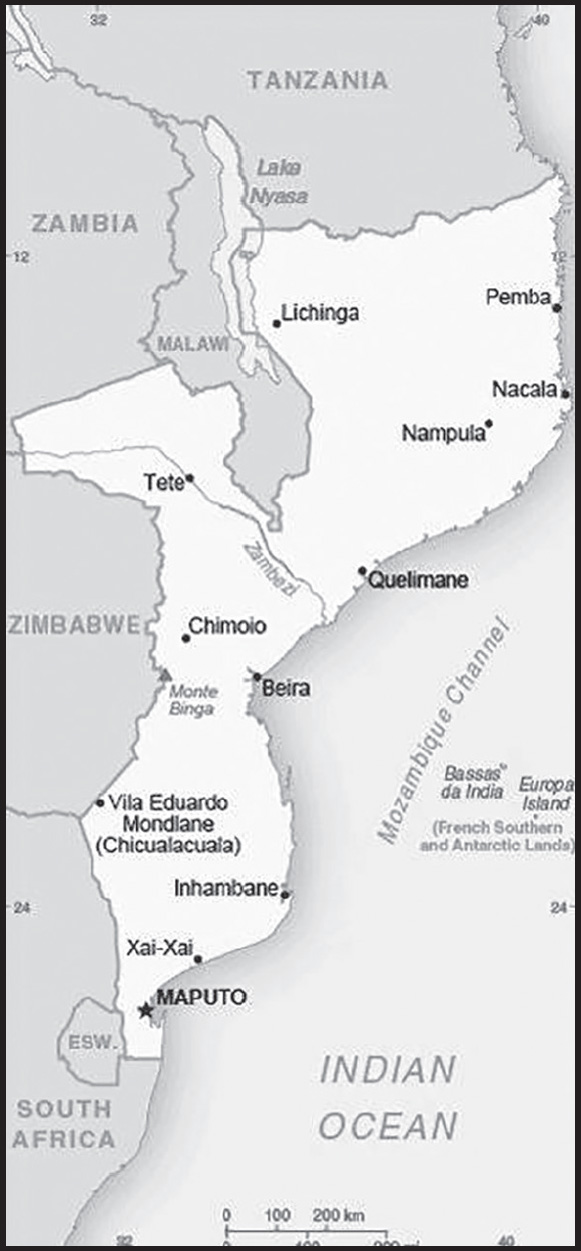
INTRODUCTION
Background: In the first half of the second millennium A.D., northern Mozambican port towns were frequented by traders from Somalia, Ethiopia, Egypt, Arabia, Persia, and India. The Portuguese were able to wrest much of the coastal trade from Arab Muslims in the centuries after 1500 and to set up their own colonies. Portugal did not relinquish Mozambique until 1975. Large-scale emigration, economic dependence on South Africa, a severe drought, and a prolonged civil war hindered the country’s development until the mid-1990s. The ruling Front for the Liberation of Mozambique (FRELIMO) party formally abandoned Marxism in 1989, and a new constitution the following year provided for multiparty elections and a free market economy. A UN-negotiated peace agreement between FRELIMO and rebel Mozambique National Resistance (RENAMO) forces ended the fighting in 1992. In 2004, Mozambique underwent a delicate transition as Joaquim CHISSANO stepped down after 18 years in office. His elected successor, Armando GUEBUZA, served two terms and then passed executive power to Filipe NYUSI in 2015. RENAMO’s residual armed forces intermittently engaged in a low-level insurgency after 2012, but a late December 2016 cease-fire eventually led to the two sides signing a comprehensive peace deal in August 2019. Elections in October 2019, challenged by Western observers and civil society as being problematic, resulted in resounding wins for NYUSI and FRELIMO across the country. Since October 2017, violent extremists - who an official ISIS media outlet recognized as ISIS’s network in Mozambique for the first time in June 2019 - have been conducting attacks against civilians and security services in the northern province of Cabo Delgado. In 2021, Rwanda and the Southern African Development Community deployed forces to support Mozambique’s efforts to counter the extremist group.
GEOGRAPHY
Location: Southeastern Africa, bordering the Mozambique Channel, between South Africa and Tanzania
Geographic coordinates: 18 15 S, 35 00 E
Map references: Africa
Area: total: 799,380 sq km
land: 786,380 sq km
water: 13,000 sq km
comparison ranking: total 36
Area - comparative: slightly more than five times the size of Georgia; slightly less than twice the size of California
Land boundaries: total: 4,783 km
border countries (6): Malawi 1498 km; South Africa 496 km; Eswatini 108 km; Tanzania 840 km; Zambia 439 km; Zimbabwe 1,402 km
Coastline: 2,470 km
Maritime claims: territorial sea: 12 nm
exclusive economic zone: 200 nm
Climate: tropical to subtropical
Terrain: mostly coastal lowlands, uplands in center, high plateaus in northwest, mountains in west
Elevation: highest point: Monte Binga 2,436 m
lowest point: Indian Ocean 0 m
mean elevation: 345 m
Natural resources: coal, titanium, natural gas, hydropower, tantalum, graphite
Land use: agricultural land: 56.3% (2018 est.)
arable land: 6.4% (2018 est.)
permanent crops: 0.3% (2018 est.)
permanent pasture: 49.6% (2018 est.)
forest: 43.7% (2018 est.)
other: 0% (2018 est.)
Irrigated land: 1,180 sq km (2012)
Major lakes (area sq km): fresh water lake(s): Lake Malawi (shared with Malawi and Tanzania) - 22,490
Major rivers (by length in km): Rio Zambeze (Zambezi) river mouth (shared with Zambia [s]), Angola, Namibia, Botswana, and Zimbabwe) - 2,740 km; Rio Limpopo river mouth (shared with South Africa [s], Botswana, and Zimbabwe) - 1,800 km
note – [s] after country name indicates river source; [m] after country name indicates river mouth
Major watersheds (area sq km): Indian Ocean drainage: Zambezi (1,332,412 sq km)
Population distribution: three large populations clusters are found along the southern coast between Maputo and Inhambane, in the central area between Beira and Chimoio along the Zambezi River, and in and around the northern cities of Nampula, Cidade de Nacala, and Pemba; the northwest and southwest are the least populated areas as shown in this population distribution map
Natural hazards: severe droughts; devastating cyclones and floods in central and southern provinces
Geography - note: the Zambezi River flows through the north-central and most fertile part of the country
PEOPLE AND SOCIETY
Population: 32,513,805 (2023 est.)
comparison ranking: 45
Nationality: noun: Mozambican(s)
adjective: Mozambican
Ethnic groups: African 99% (Makhuwa, Tsonga, Lomwe, Sena, and others), Mestizo 0.8%, other (includes European, Indian, Pakistani, Chinese) 0.2% (2017 est.)
Languages: Makhuwa 26.1%, Portuguese (official) 16.6%, Tsonga 8.6%, Nyanja 8.1, Sena 7.1%, Lomwe 7.1%, Chuwabo 4.7%, Ndau 3.8%, Tswa 3.8%, other Mozambican languages 11.8%, other 0.5%, unspecified 1.8% (2017 est.)
Religions: Roman Catholic 27.2%, Muslim 18.9%, Zionist Christian 15.6%, Evangelical/Pentecostal 15.3%, Anglican 1.7%, other 4.8%, none 13.9%, unspecified 2.5% (2017 est.)
Demographic profile: Mozambique is a poor, sparsely populated country with high fertility and mortality rates and a rapidly growing youthful population – 45% of the population is younger than 15, as of 2020. Mozambique’s high poverty rate is sustained by natural disasters, disease, high population growth, low agricultural productivity, and the unequal distribution of wealth. The country’s birth rate is among the world’s highest, averaging around 5 children per woman (and higher in rural areas) for at least the last three decades. The sustained high level of fertility reflects gender inequality, low contraceptive use, early marriages and childbearing, and a lack of education, particularly among women. The high population growth rate is somewhat restrained by the country’s high HIV/AIDS and overall mortality rates. Mozambique ranks among the worst in the world for HIV/AIDS prevalence, HIV/AIDS deaths, and life expectancy at birth, as of 2022.
Mozambique is predominantly a country of emigration, but internal, rural-urban migration has begun to grow. Mozambicans, primarily from the country’s southern region, have been migrating to South Africa for work for more than a century. Additionally, approximately 1.7 million Mozambicans fled to Malawi, South Africa, and other neighboring countries between 1979 and 1992 to escape from civil war. Labor migrants have usually been men from rural areas whose crops have failed or who are unemployed and have headed to South Africa to work as miners; multiple generations of the same family often become miners. Since the abolition of apartheid in South Africa in 1991, other job opportunities have opened to Mozambicans, including in the informal and manufacturing sectors, but mining remains their main source of employment.
Age structure: 0-14 years: 45% (male 7,413,197/female 7,217,953)
15-64 years: 52.1% (male 8,153,175/female 8,787,792)
65 years and over: 2.9% (2023 est.) (male 461,904/female 479,784)
Dependency ratios: total dependency ratio: 86.1
youth dependency ratio: 81.3
elderly dependency ratio: 4.8
potential support ratio: 20.8 (2021 est.)
Median age: total: 17 years (2020)
male: 16.3 years
female: 17.6 years
comparison ranking: total 219
Population growth rate: 2.55% (2023 est.)
comparison ranking: 17
Birth rate: 36.94 births/1,000 population (2023 est.)
comparison ranking: 10
Death rate: 9.93 deaths/1,000 population (2023 est.)
comparison ranking: 36
Net migration rate: -1.54 migrant(s)/1,000 population (2023 est.)
comparison ranking: 161
Population distribution: three large populations clusters are found along the southern coast between Maputo and Inhambane, in the central area between Beira and Chimoio along the Zambezi River, and in and around the northern cities of Nampula, Cidade de Nacala, and Pemba; the northwest and southwest are the least populated areas as shown in this population distribution map
Urbanization: urban population: 38.8% of total population (2023)
rate of urbanization: 4.24% annual rate of change (2020-25 est.)
Major urban areas - population: 1.852 million Matola, 1.163 million MAPUTO (capital), 969,000 Nampula (2023)
Sex ratio: at birth: 1.03 male(s)/female
0-14 years: 1.03 male(s)/female
15-64 years: 0.93 male(s)/female
65 years and over: 0.96 male(s)/female
total population: 0.97 male(s)/female (2023 est.)
Mother’s mean age at first birth: 19.2 years (2011 est.)
note: data represents median age at first birth among women 20-49
Maternal mortality ratio: 127 deaths/100,000 live births (2020 est.)
comparison ranking: 58
Infant mortality rate: total: 59.77 deaths/1,000 live births (2023 est.)
male: 61.72 deaths/1,000 live births
female: 57.76 deaths/1,000 live births
comparison ranking: total 9
Life expectancy at birth: total population: 57.7 years (2023 est.)
male: 56.41 years
female: 59.03 years
comparison ranking: total population 224
Total fertility rate: 4.74 children born/woman (2023 est.)
comparison ranking: 12
Gross reproduction rate: 2.33 (2023 est.)
Contraceptive prevalence rate: 27.1% (2015)
Drinking water source: improved: urban: 93.4% of population
rural: 61.5% of population
total: 73.3% of population
unimproved: urban: 6.6% of population
rural: 38.5% of population
total: 26.7% of population (2020 est.)
Current health expenditure: 7.6% of GDP (2020)
Physicians density: 0.09 physicians/1,000 population (2020)
Hospital bed density: 0.7 beds/1,000 population (2011)
Sanitation facility access: improved: urban: 71.9% of population (2015 est.)
rural: 24.7% of population
total: 42.2% of population
unimproved: urban: 28.1% of population
rural: 75.3% of population
total: 57.8% of population (2020 est.)
Major infectious diseases: degree of risk: very high (2023)
food or waterborne diseases: bacterial and protozoal diarrhea, hepatitis A, and typhoid fever
vectorborne diseases: malaria and dengue fever
water contact diseases: schistosomiasis
animal contact diseases: rabies
note: on 31 August 2023, the US Centers for Disease Control and Prevention (CDC) issued a Travel Alert for polio in Africa; Mozambique is currently considered a high risk to travelers for circulating vaccine-derived polioviruses (cVDPV); vaccine-derived poliovirus (VDPV) is a strain of the weakened poliovirus that was initially included in oral polio vaccine (OPV) and that has changed over time and behaves more like the wild or naturally occurring virus; this means it can be spread more easily to people who are unvaccinated against polio and who come in contact with the stool or respiratory secretions, such as from a sneeze, of an “infected” person who received oral polio vaccine; the CDC recommends that before any international travel, anyone unvaccinated, incompletely vaccinated, or with an unknown polio vaccination status should complete the routine polio vaccine series; before travel to any high-risk destination, the CDC recommends that adults who previously completed the full, routine polio vaccine series receive a single, lifetime booster dose of polio vaccine
Obesity - adult prevalence rate: 7.2% (2016)
comparison ranking: 160
Alcohol consumption per capita: total: 1.46 liters of pure alcohol (2019 est.)
beer: 1.03 liters of pure alcohol (2019 est.)
wine: 0.22 liters of pure alcohol (2019 est.)
spirits: 0.21 liters of pure alcohol (2019 est.)
other alcohols: 0 liters of pure alcohol (2019 est.)
comparison ranking: total 140
Tobacco use: total: 14.3% (2020 est.)
male: 23% (2020 est.)
female: 5.6% (2020 est.)
comparison ranking: total 109
Children under the age of 5 years underweight: 14.6% (2019/20)
comparison ranking: 35
Currently married women (ages 15-49): 63.7% (2023 est.)
Education expenditures: 6.3% of GDP (2020 est.)
comparison ranking: 35
Literacy: definition: age 15 and over can read and write
total population: 63.4%
male: 74.1%
female: 53.8% (2021)
School life expectancy (primary to tertiary education): total: 10 years
male: 10 years
female: 9 years (2017)
Youth unemployment rate (ages 15-24): total: 8.1% (2021 est.)
male: 8.1%
female: 8.2%
comparison ranking: total 168
ENVIRONMENT
Environment - current issues: increased migration of the population to urban and coastal areas with adverse environmental consequences; desertification; soil erosion; deforestation; water pollution caused by artisanal mining; pollution of surface and coastal waters; wildlife preservation (elephant poaching for ivory)
Environment - international agreements: party to: Biodiversity, Climate Change, Climate Change-Kyoto Protocol, Climate Change-Paris Agreement, Comprehensive Nuclear Test Ban, Desertification, Endangered Species, Hazardous Wastes, Law of the Sea, Ozone Layer Protection, Ship Pollution, Tropical Timber 2006, Wetlands
signed, but not ratified: none of the selected agreements
Climate: tropical to subtropical
Land use: agricultural land: 56.3% (2018 est.)
arable land: 6.4% (2018 est.)
permanent crops: 0.3% (2018 est.)
permanent pasture: 49.6% (2018 est.)
forest: 43.7% (2018 est.)
other: 0% (2018 est.)
Urbanization: urban population: 38.8% of total population (2023)
rate of urbanization: 4.24% annual rate of change (2020-25 est.)
Food insecurity: severe localized food insecurity: due to shortfall in agricultural production and economic downturn - the number of people in need of food assistance is expected to rise above the 1.86 million estimated in 2021-2022 because of three key factors; firstly, higher year-on-year prices of food and fuel are reducing households’ purchasing power, worsening their economic access to food, particularly for low-income households; secondly, the impact of extreme weather events on agricultural production in central and southern provinces in 2022 is likely to mean that farming households in the affected areas have both low food supplies from their own production and curtailed income-earning opportunities from crop sales, impinging on their food availability and economic access to food; thirdly, there has been an increase in attacks by non-state armed groups in the northern province of Cabo Delgado in 2022
(2022)
Revenue from forest resources: 6.46% of GDP (2018 est.)
comparison ranking: 9
Revenue from coal: 4.17% of GDP (2018 est.)
comparison ranking: 2
Air pollutants: particulate matter emissions: 16.45 micrograms per cubic meter (2019 est.)
carbon dioxide emissions: 7.94 megatons (2016 est.)
methane emissions: 16.26 megatons (2020 est.)
Waste and recycling: municipal solid waste generated annually: 2.5 million tons (2014 est.)
municipal solid waste recycled annually: 25,000 tons (2014 est.)
percent of municipal solid waste recycled: 1% (2014 est.)
Major lakes (area sq km): fresh water lake(s): Lake Malawi (shared with Malawi and Tanzania) - 22,490
Major rivers (by length in km): Rio Zambeze (Zambezi) river mouth (shared with Zambia [s]), Angola, Namibia, Botswana, and Zimbabwe) - 2,740 km; Rio Limpopo river mouth (shared with South Africa [s], Botswana, and Zimbabwe) - 1,800 km
note – [s] after country name indicates river source; [m] after country name indicates river mouth
Major watersheds (area sq km): Indian Ocean drainage: Zambezi (1,332,412 sq km)
Total water withdrawal: municipal: 370 million cubic meters (2020 est.)
industrial: 30 million cubic meters (2020 est.)
agricultural: 1.08 billion cubic meters (2020 est.)
Total renewable water resources: 217.1 billion cubic meters (2020 est.)
GOVERNMENT
Country name: conventional long form: Republic of Mozambique
conventional short form: Mozambique
local long form: Republica de Mocambique
local short form: Mocambique
former: Portuguese East Africa, People’s Republic of Mozambique
etymology: named for the offshore island of Mozambique; the island was apparently named after Mussa al-BIK, an influential Arab slave trader who set himself up as sultan on the island in the 15th century
Government type: presidential republic
Capital: name: Maputo
geographic coordinates: 25 57 S, 32 35 E
time difference: UTC+2 (7 hours ahead of Washington, DC, during Standard Time)
etymology: reputedly named after the Maputo River, which drains into Maputo Bay south of the city
Administrative divisions: 10 provinces (provincias, singular - provincia), 1 city (cidade)*; Cabo Delgado, Gaza, Inhambane, Manica, Maputo, Cidade de Maputo*, Nampula, Niassa, Sofala, Tete, Zambezia
Independence: 25 June 1975 (from Portugal)
National holiday: Independence Day, 25 June (1975)
Constitution: history: previous 1975, 1990; latest adopted 16 November 2004, effective 21 December 2004
amendments: proposed by the president of the republic or supported by at least one third of the Assembly of the Republic membership; passage of amendments affecting constitutional provisions, including the independence and sovereignty of the state, the republican form of government, basic rights and freedoms, and universal suffrage, requires at least a two-thirds majority vote by the Assembly and approval in a referendum; referenda not required for passage of other amendments; amended 2007, 2018
Legal system: mixed legal system of Portuguese civil law and customary law
International law organization participation: has not submitted an ICJ jurisdiction declaration; non-party state to the ICCt
Citizenship: citizenship by birth: no
citizenship by descent only: at least one parent must be a citizen of Mozambique
dual citizenship recognized: no
residency requirement for naturalization: 5 years
Suffrage: 18 years of age; universal
Executive branch: chief of state: President Filipe Jacinto NYUSI (since 15 January 2015); note - the president is both chief of state and head of government
head of government: President Filipe Jacinto NYUSI (since 15 January 2015); Prime Minister Adriano Afonso MALEIANE (since 3 March 2022); note - President NYUSI removed Prime Minister Carlos Agostinho DO ROSARIO from office on 3 March 2022 as part of a cabinet reshuffle
cabinet: Cabinet appointed by the president
elections/appointments: president elected directly by absolute majority popular vote in 2 rounds if needed for a 5-year term (eligible for 2 consecutive terms); election last held on 15 October 2019 (next to be held on 9 October 2024); prime minister appointed by the president
election results:
2019: Filipe NYUSI reelected president in first round; percent of vote - Filipe NYUSI (FRELIMO) 73.0%, Ossufo MOMADE (RENAMO) 21.9%, Daviz SIMANGO (MDM) 5.1%
2014: Filipe NYUSI elected president in first round; percent of vote - Filipe NYUSI (FRELIMO) 57.0%, Afonso DHLAKAMA (RENAMO) 36.6%, Daviz SIMANGO (MDM) 6.4%
Legislative branch: description: unicameral Assembly of the Republic or Assembleia da Republica (250 seats; 248 members elected in multi-seat constituencies by party-list proportional representation vote and 2 members representing Mozambicans abroad directly elected by simple majority vote; members serve 5-year terms)
elections: last held on 15 October 2019 (next to be held on 15 October 2024)
election results: percent of vote by party - FRELIMO 71%, RENAMO 23%, MDM 4%; seats by party - FRELIMO 184, RENAMO 60, MDM 6; composition as of July 2022 - men 144, women 106, percent of women 42.4%
Judicial branch: highest court(s): Supreme Court (consists of the court president, vice president, and 5 judges); Constitutional Council (consists of 7 judges); note - the Higher Council of the Judiciary Magistracy is responsible for judiciary management and discipline
judge selection and term of office: Supreme Court president appointed by the president of the republic; vice president appointed by the president in consultation with the Higher Council of the Judiciary (CSMJ) and ratified by the Assembly of the Republic; other judges elected by the Assembly; judges serve 5-year renewable terms; Constitutional Council judges appointed - 1 by the president, 5 by the Assembly, and 1 by the CSMJ; judges serve 5-year nonrenewable terms
subordinate courts: Administrative Court (capital city only); provincial courts or Tribunais Judicias de Provincia; District Courts or Tribunais Judicias de Districto; customs courts; maritime courts; courts marshal; labor courts; community courts
Political parties and leaders: Democratic Movement of Mozambique (Movimento Democratico de Mocambique) or MDM [vacant]
Liberation Front of Mozambique (Frente de Liberatacao de Mocambique) or FRELIMO [Filipe NYUSI]
Mozambican National Resistance (Resistencia Nacional Mocambicana) or RENAMO [Ossufo MOMADE]
note: only parties with seats in the legislature listed
International organization participation: ACP, AfDB, AU, C, CD, CPLP, EITI (compliant country), FAO, G-77, IAEA, IBRD, ICAO, ICC (NGOs), ICRM, IDA, IDB, IFAD, IFC, IFRCS, IHO, ILO, IMF, IMO, IMSO, Interpol, IOC, IOM, IPU, ISO (correspondent), ITSO, ITU, ITUC (NGOs), MIGA, NAM, OIC, OIF (observer), OPCW, SADC, UN, UNCDF, UNCTAD, UNDP, UNDSS, UNECA, UNEP, UNESCO, UNFPA, UNHCR, UNIDO, UNODC, UNOPS, UNV, UNWTO, Union Latina, UPU, WCO, WFP, WFTU (NGOs), WHO, WIPO, WMO, WTO
Diplomatic representation in the US: chief of mission: Ambassador Alfredo Fabaio NUVUNGA (since 19 April 2023)
chancery: 1525 New Hampshire Avenue NW, Washington, DC 20036
telephone: [1] (202) 293-7147
FAX: [1] (202) 835-0245
email address and website:
Diplomatic representation from the US: chief of mission: Ambassador Peter Hendrick VROOMAN (since 3 March 2022)
embassy: Avenida Kenneth Kaunda, 193, Caixa Postal, 783, Maputo
mailing address: 2330 Maputo Place, Washington DC 20521-2330
telephone: [258] (21) 49-27-97
FAX: [258] (21) 49-01-14
email address and website:
Flag description: three equal horizontal bands of green (top), black, and yellow with a red isosceles triangle based on the hoist side; the black band is edged in white; centered in the triangle is a yellow five-pointed star bearing a crossed rifle and hoe in black superimposed on an open white book; green represents the riches of the land, white peace, black the African continent, yellow the country’s minerals, and red the struggle for independence; the rifle symbolizes defense and vigilance, the hoe refers to the country’s agriculture, the open book stresses the importance of education, and the star represents Marxism and internationalism
note: one of only two national flags featuring a firearm, the other is Guatemala
National symbol(s): national colors: green, black, yellow, white, red
National anthem: name: “Patria Amada” (Lovely Fatherland)
lyrics/music: Salomao J. MANHICA/unknown
note: adopted 2002
National heritage: total World Heritage Sites: 1 (cultural)
selected World Heritage Site locales: Island of Mozambique
ECONOMY
Economic overview: low-income East African economy; mostly rural labor force; natural resource rich; strong South African ties; Islamist terrorism in north endangers newly discovered natural gas; currently in court over massive (possibly unauthorized) debt
Real GDP (purchasing power parity): $39.351 billion (2021 est.)
$38.442 billion (2020 est.)
$38.923 billion (2019 est.)
note: data are in 2017 dollars
comparison ranking: 123
Real GDP growth rate: 2.36% (2021 est.)
-1.23% (2020 est.)
2.31% (2019 est.)
comparison ranking: 156
Real GDP per capita: $1,200 (2021 est.)
$1,200 (2020 est.)
$1,300 (2019 est.)
note: data are in 2017 dollars
comparison ranking: 224
GDP (official exchange rate): $14.964 billion (2019 est.)
Inflation rate (consumer prices): 5.69% (2021 est.)
3.14% (2020 est.)
2.78% (2019 est.)
comparison ranking: 56
Credit ratings: Fitch rating: CCC (2019)
Moody’s rating: Caa2 (2019)
Standard & Poors rating: CCC+ (2019)
note: The year refers to the year in which the current credit rating was first obtained.
GDP - composition, by sector of origin: agriculture: 23.9% (2017 est.)
industry: 19.3% (2017 est.)
services: 56.8% (2017 est.)
comparison rankings: services 144; industry 156; agriculture 33
GDP - composition, by end use: household consumption: 69.7% (2017 est.)
government consumption: 27.2% (2017 est.)
investment in fixed capital: 21.7% (2017 est.)
investment in inventories: 13.9% (2017 est.)
exports of goods and services: 38.3% (2017 est.)
imports of goods and services: -70.6% (2017 est.)
Agricultural products: sugar cane, cassava, maize, milk, bananas, tomatoes, sweet potatoes, rice, sorghum, potatoes
Industries: aluminum, petroleum products, chemicals (fertilizer, soap, paints), textiles, cement, glass, asbestos, tobacco, food, beverages
Industrial production growth rate: -0.42% (2019 est.)
comparison ranking: 160
Labor force: 14.137 million (2021 est.)
comparison ranking: 43
Labor force - by occupation: agriculture: 74.4%
industry: 3.9%
services: 21.7% (2015 est.)
Unemployment rate: 3.98% (2021 est.)
3.81% (2020 est.)
3.47% (2019 est.)
comparison ranking: 176
Youth unemployment rate (ages 15-24): total: 8.1% (2021 est.)
male: 8.1%
female: 8.2%
comparison ranking: total 168
Population below poverty line: 46.1% (2014 est.)
Gini Index coefficient - distribution of family income: 54 (2014 est.)
comparison ranking: 7
Household income or consumption by percentage share: lowest 10%: 1.9%
highest 10%: 36.7% (2008)
Budget: revenues: $4.569 billion (2019 est.)
expenditures: $4.591 billion (2019 est.)
Budget surplus (+) or deficit (-): -5.6% (of GDP) (2017 est.)
comparison ranking: 175
Public debt: 102.88% of GDP (2020 est.)
79.51% of GDP (2019 est.)
82.3% of GDP (2018 est.)
comparison ranking: 22
Taxes and other revenues: 21.84% (of GDP) (2020 est.)
comparison ranking: 74
Fiscal year: calendar year
Current account balance: -$3.601 billion (2021 est.)
-$3.869 billion (2020 est.)
-$2.934 billion (2019 est.)
comparison ranking: 177
Exports: $6.404 billion (2021 est.) note: data are in current year dollars
$4.37 billion (2020 est.) note: data are in current year dollars
$5.6 billion (2019 est.) note: data are in current year dollars
comparison ranking: 121
Exports - partners: South Africa 16%, India 13%, China 12%, Italy 7%, United Arab Emirates 5%, Germany 5% (2019)
Exports - commodities: coal, aluminum, gold, natural gas, electricity, titanium, coke (2021)
Imports: $10.392 billion (2021 est.) note: data are in current year dollars
$8.63 billion (2020 est.) note: data are in current year dollars
$9.503 billion (2019 est.) note: data are in current year dollars
comparison ranking: 111
Imports - partners: South Africa 31%, India 18%, China 17% (2019)
Imports - commodities: refined petroleum, chromium, iron, bauxite, electricity (2019)
Reserves of foreign exchange and gold: $67.51 billion (31 December 2021 est.)
$47.597 billion (31 December 2020 est.)
$20.664 billion (31 December 2019 est.)
comparison ranking: 35
Debt - external: $10.91 billion (31 December 2017 est.)
$10.48 billion (31 December 2016 est.)
comparison ranking: 111
Exchange rates: meticais (MZM) per US dollar -
Exchange rates: 65.465 (2021 est.)
69.465 (2020 est.)
62.548 (2019 est.)
60.326 (2018 est.)
63.584 (2017 est.)
ENERGY
Electricity access: population without electricity: 19 million (2020)
electrification - total population: 31.4% (2021)
electrification - urban areas: 77.3% (2021)
electrification - rural areas: 3.8% (2021)
Electricity: installed generating capacity: 2.765 million kW (2020 est.)
consumption: 12,724,100,000 kWh (2019 est.)
exports: 10.771 billion kWh (2019 est.)
imports: 8.276 billion kWh (2019 est.)
transmission/distribution losses: 2.768 billion kWh (2019 est.)
comparison rankings: installed generating capacity 111; transmission/distribution losses 69; imports 27; exports 20; consumption 89
Electricity generation sources: fossil fuels: 19.6% of total installed capacity (2020 est.)
solar: 0.2% of total installed capacity (2020 est.)
hydroelectricity: 79.6% of total installed capacity (2020 est.)
biomass and waste: 0.6% of total installed capacity (2020 est.)
Coal: production: 7.25 million metric tons (2020 est.)
consumption: 46,000 metric tons (2020 est.)
exports: 8.355 million metric tons (2020 est.)
imports: 48,000 metric tons (2020 est.)
proven reserves: 1.792 billion metric tons (2019 est.)
Petroleum: total petroleum production: 0 bbl/day (2021 est.)
refined petroleum consumption: 35,400 bbl/day (2019 est.)
Refined petroleum products - imports: 25,130 bbl/day (2015 est.)
comparison ranking: 107
Natural gas: production: 5,423,828,000 cubic meters (2019 est.)
consumption: 1,397,604,000 cubic meters (2019 est.)
exports: 4,067,255,000 cubic meters (2019 est.)
imports: 0 cubic meters (2021 est.)
proven reserves: 2,831,680,000,000 cubic meters (2021 est.)
Carbon dioxide emissions: 7.753 million metric tonnes of CO2 (2019 est.)
from coal and metallurgical coke: 109,000 metric tonnes of CO2 (2019 est.)
from petroleum and other liquids: 4.743 million metric tonnes of CO2 (2019 est.)
from consumed natural gas: 2.901 million metric tonnes of CO2 (2019 est.)
comparison ranking: total emissions 119
Energy consumption per capita: 8.107 million Btu/person (2019 est.)
comparison ranking: 162
COMMUNICATIONS
Telephones - fixed lines: total subscriptions: 59,682 (2021 est.)
subscriptions per 100 inhabitants: (2021 est.) less than 1
comparison ranking: total subscriptions 150
Telephones - mobile cellular: total subscriptions: 13,686,234 (2021 est.)
subscriptions per 100 inhabitants: 43 (2021 est.)
comparison ranking: total subscriptions 75
Telecommunication systems: general assessment: one of the first countries in the region to embark upon telecom reform and to open the sector to competition; the mobile segment in particular has shown strong growth; additional competition followed in late 2020; a new licensing regime ensured that by mid-2019 all operators had been provided with universal licenses, enabling them to offer all types of telephony and data services; mobile, fixed-line and broadband penetration rates remain far below the average for the region; in recent years the government has enforced the registration of SIM cards, but with varying success; at the end of 2016 almost five million unregistered SIM cards were deactivated but poor monitoring meant that the process was revisited in mid-2019 and again in late 2020; the high cost of international bandwidth had long hampered internet use, though the landing of two international submarine cables (SEACOM and EASSy) has reduced the cost of bandwidth and so led to drastic reductions in broadband retail prices as well as a significant jump in available bandwidth; there is some cross-platform competition, with DSL, cable, fibre, WiMAX, and mobile broadband options available, though fixed broadband options can be limited to urban areas; improvements can be expected from the ongoing rollout of a national fiber backbone networks and of upgrades to mobile infrastructure (2022)
domestic: fixed-line less than 1 per 100 and nearly 43 per 100 mobile-cellular teledensity (2021)
international: country code - 258; landing points for the EASSy and SEACOM/ Tata TGN-Eurasia fiber-optic submarine cable systems linking numerous east African countries, the Middle East and Asia ; satellite earth stations - 5 Intelsat (2 Atlantic Ocean and 3 Indian Ocean); TdM contracts for Itelsat for satellite broadband and bulk haul services (2020)
Broadcast media: 1 state-run TV station supplemented by private TV station; Portuguese state TV’s African service, RTP Africa, and Brazilian-owned TV Miramar are available; state-run radio provides nearly 100% territorial coverage and broadcasts in multiple languages; a number of privately owned and community-operated stations; transmissions of multiple international broadcasters are available (2019)
Internet country code: .mz
Internet users: total: 5.44 million (2021 est.)
percent of population: 17% (2021 est.)
comparison ranking: total 86
Broadband - fixed subscriptions: total: 70,000 (2020 est.)
subscriptions per 100 inhabitants: 0.2 (2020 est.)
comparison ranking: total 136
TRANSPORTATION
National air transport system: number of registered air carriers: 2 (2020)
inventory of registered aircraft operated by air carriers: 11
annual passenger traffic on registered air carriers: 540,124 (2018)
annual freight traffic on registered air carriers: 4.78 million (2018) mt-km
Civil aircraft registration country code prefix: C9
Airports: 98 (2021)
comparison ranking: total 58
Airports - with paved runways: 21
note: paved runways have a concrete or asphalt surface but not all have facilities for refueling, maintenance, or air traffic control; the length of a runway required for aircraft to safely operate depends on a number of factors including the type of aircraft, the takeoff weight (including passengers, cargo, and fuel), engine types, flap settings, landing speed, elevation of the airport, and average maximum daily air temperature; paved runways can reach a length of 5,000 m (16,000 ft.), but the “typical” length of a commercial airline runway is between 2,500-4,000 m (8,000-13,000 ft.)
Airports - with unpaved runways: 77
note: unpaved runways have a surface composition such as grass or packed earth and are most suited to the operation of light aircraft; unpaved runways are usually short, often less than 1,000 m (3,280 ft.) in length; airports with unpaved runways often lack facilities for refueling, maintenance, or air traffic control
Pipelines: 972 km gas, 278 km refined products (2013)
Railways: total: 4,787 km (2014)
narrow gauge: 4,787 km (2014) 1.067-m gauge
comparison ranking: total 40
Roadways: total: 31,083 km (2015)
paved: 7,365 km (2015)
unpaved: 23,718 km (2015)
comparison ranking: total 96
Waterways: 460 km (2010) (Zambezi River navigable to Tete and along Cahora Bassa Lake)
comparison ranking: 93
Merchant marine: total: 30 (2022)
by type: general cargo 9, other 21
comparison ranking: total 135
Ports and terminals: major seaport(s): Beira, Maputo, Nacala
LNG terminal(s) (export): Coral Sul (FLNG)
MILITARY AND SECURITY
Military and security forces: Armed Forces for the Defense of Mozambique (Forcas Armadas de Defesa de Mocambique, FADM): Mozambique Army (Ramo do Exercito), Mozambique Navy (Marinha de Guerra de Mocambique, MGM), Mozambique Air Force (Forca Aerea de Mocambique, FAM)
Ministry of Interior: Mozambique National Police (PRM), the National Criminal Investigation Service (SERNIC), Rapid Intervention Unit (UIR; police special forces), Border Security Force; other security forces include the Presidential Guard and the Force for the Protection of High-Level Individuals (2023)
note 1: the FADM and other security forces are referred to collectively as the Defense and Security Forces (DFS)
note 2: the PRM, SERNIC, and the UIR are responsible for law enforcement and internal security; the Border Security Force is responsible for protecting the country’s international borders and for carrying out police duties within 24 miles of borders
note 3: the Presidential Guard provides security for the president, and the Force for the Protection of High-level Individuals provides security for senior-level officials at the national and provincial levels
Military expenditures: 1.2% of GDP (2022 est.)
1.2% of GDP (2021 est.)
1.1% of GDP (2020 est.)
1.2% of GDP (2019 est.)
1.1% of GDP (2018 est.)
comparison ranking: 113
Military and security service personnel strengths: information limited and varied; estimated 12,000 active personnel (11,000 Army and about 1,000 Air Force and Navy) (2023)
Military equipment inventories and acquisitions: the FADM’s inventory consists primarily of Soviet-era equipment, although in recent years it has received limited quantities of more modern equipment from a variety of countries, mostly as aid/donations (2023)
Military service age and obligation: registration for military service is mandatory for all men and women at 18 years of age; 18-35 years of age for selective compulsory military service; 18 years of age for voluntary service for men and women; 24-month service obligation (2023)
Military - note: the FADM is responsible for external security, cooperating with police on internal security, and responding to natural disasters and other emergencies; the current primary focus of the FADM is countering an insurgency driven by militants with ties to the Islamic State of Iraq and ash-Sham (ISIS) terrorist group in the northern province of Cabo Delgado, an area known for rich liquid natural gas deposits; insurgent attacks in the province began in 2017 and the fighting has left over 4,000 estimated dead and nearly 1 million displaced; the FADM is widely assessed as lacking the training, equipment, and overall capabilities to address the insurgency; several countries from the Southern Africa Development Community (SADC) and the EU, as well as Rwanda and the US are providing various forms of military assistance; the SADC countries and Zambia have sent more than 3,000 military and security personnel, while some EU member states and the US have provided training assistance
the FADM’s Army is comprised largely of light infantry supplemented by several battalions of artillery and special forces; the Air Force has small numbers of Soviet-era combat aircraft and helicopters
in 2023, the Mozambique Government legalized local militias that have been assisting security forces operating in Cabo Delgado against Islamic militants since 2020; this Local Force is comprised of ex-combatants and other civilians and is to receive training, uniforms, weapons, and logistical support from the FADM (2023)
TERRORISM
Terrorist group(s): Terrorist group(s): Islamic State of Iraq and ash-Sham - Mozambique (ISIS-M)
note: details about the history, aims, leadership, organization, areas of operation, tactics, targets, weapons, size, and sources of support of the group(s) appear(s) in Appendix-T
TRANSNATIONAL ISSUES
Disputes - international: Mozambique-Eswatini: none identified
Mozambique-Malawi: the two countries have held exercises to reaffirm boundaries a number of times
Mozambique-South Africa: South Africa has placed military units to assist police operations along the border of Lesotho, Zimbabwe, and Mozambique to control smuggling, poaching, and illegal migration
Mozambique-Tanzania: none identified
Mozambique-Zambia: none identified
Mozambique-Zimbabwe: none identified
Refugees and internally displaced persons: refugees (country of origin): 12,810 (Democratic Republic of Congo) (refugees and asylum seekers), 10,655 (Burundi) (refugees and asylum seekers) (2023)
IDPs: 850,599 (north Mozambique, violence between the government and an opposition group, violence associated with extremists groups in 2018, political violence 2019) (2023)
Trafficking in persons: tier rating: Tier 2 Watch List — Mozambique does not fully meet the minimum standards for the elimination of trafficking but is making significant efforts to do so; the government increased investigations and prosecutions, trained law enforcement and front-line officials, published and disseminated draft standard operating procedures (SOPs) for victim referral and care and raising public awareness; officials convened government and civil society stakeholders and coordinated with neighboring governments; however, the government did not demonstrate overall increasing efforts, compared with the previous reporting period, to expand its anti-trafficking capacity; despite increased investigations, Mozambique did not report identifying any victims and lacked adequate procedures to screen vulnerable populations for trafficking; for the seventh consecutive year, the government failed to adopt its draft National Referral Mechanism and SOPs for care and referral of victims; Mozambique did not report providing financial or in-kind support to the civil society organizations that identify and assist victims; the lack of a formally adopted National Action Plan, including dedicated resources for preventing trafficking, reduced integration of anti-trafficking efforts; reports of low-level official complicity in trafficking crimes persisted; the government did not provide sufficient resources to victim protection services, relying on NGOs and international organizations to provide the majority of services to victims; the government lacked effective policies or laws to regulate foreign labor recruiters and hold them liable for fraudulent recruiting; therefore, Mozambique was downgraded to Tier 2 Watch List (2023)
trafficking profile: human traffickers exploit domestic and foreign victims in Mozambique, as well as Mozambicans abroad; forced child labor occurs in agriculture, mining, and market vending in rural areas, often with the complicity of family members; migrants, especially women and girls from rural areas in neighboring countries such as Malawi, are lured to cities in Mozambique, Eswatini, or South Africa with promises of employment or education but are exploited in domestic servitude or sex trafficking; individuals with albinism may be vulnerable to sex and labor trafficking by traditional healers; Mozambican girls are exploited in bars, roadside clubs, overnight stopping points, and restaurants along the southern transport corridor that links Maputo with Eswatini and South Africa; girls are exploited in sex trafficking in and around mining worksites; women and girls are recruited online with false employment promises, then exploited in sex trafficking or forced labor; children from vulnerable families are at risk of trafficking, including children from Gaza province who migrate to Maputo and work in street vending; child sex trafficking is prevalent in the cities that have highly mobile populations and large numbers of long-distance truck drivers; individuals in displacement camps or otherwise affected by cyclones were vulnerable to trafficking; non-state armed groups exploited women and children, among the over one million IDPs in northern and central Mozambique displaced by violent extremism, in forced labor and sex trafficking; non-state armed groups also recruited or used child soldiers; extremists lure youth with promises of employment in the fishing sector, and then force them to fight with non-state armed groups; Mozambican men and boys are exploited in forced labor on South African farms and mines before being turned over to police for deportation as undocumented migrants; Mozambican boys who migrate to Eswatini are at risk of forced labor; Mozambican adults and girls are exploited in forced labor and sex trafficking abroad, including in Angola, Cyprus, Germany, Hungary, Italy, and Portugal; traffickers allegedly bribe officials to move victims within the country and across borders to Eswatini and South Africa (2023)
Illicit drugs: a transit country for large shipments of heroin and methamphetamine originating from Afghanistan to primarily South Africa