NEW ZEALAND
INTRODUCTION
Background: Polynesian settlers may have arrived in New Zealand in the late 1200s, with widespread settlement in the mid-1300s. They called the land Aotearoa, which legend holds is the name of the canoe that Kupe, the first Polynesian in New Zealand, used to sail to the country; the name Aotearoa is now in widespread use as the local Maori name for the country. Competition for land and resources led to intermittent fighting between different Maori iwi (tribes) by the 1500s as large game became extinct. Dutch explorer Abel TASMAN was the first European to see the islands in 1642 but after an encounter with local Maori, he sailed away. British captain James COOK was the next European to arrive in New Zealand in 1769, followed by whalers, sealers, and traders. The UK only nominally claimed New Zealand and included it as part of New South Wales in Australia. Concerns about increasing lawlessness led the UK to appoint its first British Resident in New Zealand in 1832, although he had few legal powers. In 1835, some Maori iwi from the North Island declared independence as the United Tribes of New Zealand. Fearing an impending French settlement and takeover, they asked the British for protection. In 1840, the British negotiated their protection in the Treaty of Waitangi, which was eventually signed by more than 500 different Maori chiefs, although many chiefs did not or were not asked to sign. In the English-language version of the treaty, the British thought the Maori ceded their land to the UK, but translations of the treaty appeared to give the British less authority, and land tenure issues stemming from the treaty are still present and being actively negotiated in New Zealand.
The UK declared New Zealand a separate colony in 1841 and gave it limited self-government in 1852. Different traditions of authority and land use led to a series of wars from the 1840s to the 1870s fought between Europeans and various Maori iwi. Along with disease, these conflicts halved the Maori population. In the 1890s, New Zealand initially expressed interest in joining independence talks with Australia but ultimately opted against it and changed its status to an independent dominion in 1907. New Zealand provided more than 100,000 troops during each World War, many of whom fought as part of the Australia and New Zealand Army Corps (ANZAC). New Zealand reaffirmed its independence in 1947, signed the Australia, New Zealand, and US (ANZUS) Treaty, and militarily supported the US in the Korean and Vietnam Wars. Beginning in 1984, New Zealand began to adopt nuclear-free policies, contributing to a dispute with the US over naval ship visits that led the US to suspend its defense obligations to New Zealand in 1986.
In recent years, New Zealand has explored reducing some of its ties to the UK. There in an active, minority movement about changing New Zealand to a republic, and in 2015-16, a referendum on changing the New Zealand flag to remove the Union Jack failed 57% to 43%.
GEOGRAPHY
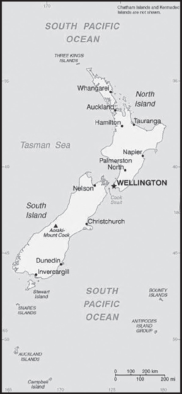
Location: Oceania, islands in the South Pacific Ocean, southeast of Australia
Geographic coordinates: 41 00 S, 174 00 E
Map references: Oceania
Area: total: 268,838 sq km
land: 264,537 sq km
water: 4,301 sq km
note: includes Antipodes Islands, Auckland Islands, Bounty Islands, Campbell Island, Chatham Islands, and Kermadec Islands
comparison ranking: total 77
Area - comparative: almost twice the size of North Carolina; about the size of Colorado
Land boundaries: total: 0 km
Coastline: 15,134 km
Maritime claims: territorial sea: 12 nm
contiguous zone: 24 nm
exclusive economic zone: 200 nm
continental shelf: 200 nm or to the edge of the continental margin
Climate: temperate with sharp regional contrasts
Terrain: predominately mountainous with large coastal plains
Elevation: highest point: Aoraki/Mount Cook 3,724 m; note - the mountain’s height was 3,764 m until 14 December 1991 when it lost about 10 m in an avalanche of rock and ice; erosion of the ice cap since then has brought the height down another 30 m
lowest point: Pacific Ocean 0 m
mean elevation: 388 m
Natural resources: natural gas, iron ore, sand, coal, timber, hydropower, gold, limestone
Land use: agricultural land: 43.2% (2018 est.)
arable land: 1.8% (2018 est.)
permanent crops: 0.3% (2018 est.)
permanent pasture: 41.1% (2018 est.)
forest: 31.4% (2018 est.)
other: 25.4% (2018 est.)
Irrigated land: 7,000 sq km (2014)
Major lakes (area sq km): fresh water lake(s): Lake Taupo - 610 sq km
Population distribution: over three-quarters of New Zealanders, including the indigenous Maori, live on the North Island, primarily in urban areas
Natural hazards: earthquakes are common, though usually not severe; volcanic activity
volcanism: significant volcanism on North Island; Ruapehu (2,797 m), which last erupted in 2007, has a history of large eruptions in the past century; Taranaki has the potential to produce dangerous avalanches and lahars; other historically active volcanoes include Okataina, Raoul Island, Tongariro, and White Island; see note 2 under “Geography - note”
Geography - note: note 1: consists of two main islands and a number of smaller islands; South Island, the larger main island, is the 12th largest island in the world and is divided along its length by the Southern Alps; North Island is the 14th largest island in the world and is not as mountainous, but it is marked by volcanism
note 2: New Zealand lies along the Ring of Fire, a belt of active volcanoes and earthquake epicenters bordering the Pacific Ocean; up to 90% of the world’s earthquakes and some 75% of the world’s volcanoes occur within the Ring of Fire
note 3: almost 90% of the population lives in cities and over three-quarters on North Island; Wellington is the southernmost national capital in the world
PEOPLE AND SOCIETY
Population: 5,109,702 (2023 est.)
comparison ranking: 125
Nationality: noun: New Zealander(s)
adjective: New Zealand
Ethnic groups: European 64.1%, Maori 16.5%, Chinese 4.9%, Indian 4.7%, Samoan 3.9%, Tongan 1.8%, Cook Islands Maori 1.7%, English 1.5%, Filipino 1.5%, New Zealander 1%, other 13.7% (2018 est.)
note: based on the 2018 census of the usually resident population; percentages add up to more than 100% because respondents were able to identify more than one ethnic group
Languages: English (de facto official) 95.4%, Maori (de jure official) 4%, Samoan 2.2%, Northern Chinese 2%, Hindi 1.5%, French 1.2%, Yue 1.1%, New Zealand Sign Language (de jure official) 0.5%, other or not stated 17.2% (2018 est.)
note: shares sum to 124.1% due to multiple responses on the 2018 census
Religions: Christian 37.3% (Catholic 10.1%, Anglican 6.8%, Presbyterian and Congregational 5.2%, Pentecostal 1.8%, Methodist 1.6%, Church of Jesus Christ 1.2%, other 10.7%), Hindu 2.7%, Maori 1.3%, Muslim, 1.3%, Buddhist 1.1%, other religion 1.6% (includes Judaism, Spiritualism and New Age religions, Baha’i, Asian religions other than Buddhism), no religion 48.6%, objected to answering 6.7% (2018 est.)
note: based on the 2018 census of the usually resident population; percentages add up to more than 100% because respondents were able to identify more than one religion
Age structure: 0-14 years: 19.15% (male 503,190/female 475,527)
15-64 years: 64.36% (male 1,661,312/female 1,627,304)
65 years and over: 16.49% (2023 est.) (male 394,339/female 448,030)
Dependency ratios: total dependency ratio: 53.4
youth dependency ratio: 29
elderly dependency ratio: 24.4
potential support ratio: 4.1 (2021 est.)
Median age: total: 37.2 years (2020)
male: 36.4 years
female: 37.9 years
comparison ranking: total 72
Population growth rate: 1.06% (2023 est.)
comparison ranking: 88
Birth rate: 12.69 births/1,000 population (2023 est.)
comparison ranking: 140
Death rate: 6.89 deaths/1,000 population (2023 est.)
comparison ranking: 124
Net migration rate: 4.81 migrant(s)/1,000 population (2023 est.)
comparison ranking: 21
Population distribution: over three-quarters of New Zealanders, including the indigenous Maori, live on the North Island, primarily in urban areas
Urbanization: urban population: 87% of total population (2023)
rate of urbanization: 0.92% annual rate of change (2020-25 est.)
Major urban areas - population: 1.673 million Auckland, 422,000 WELLINGTON (capital) (2023)
Sex ratio: at birth: 1.05 male(s)/female
0-14 years: 1.06 male(s)/female
15-64 years: 1.02 male(s)/female
65 years and over: 0.88 male(s)/female
total population: 1 male(s)/female (2023 est.)
Mother’s mean age at first birth: 27.8 years
Maternal mortality ratio: 7 deaths/100,000 live births (2020 est.)
comparison ranking: 156
Infant mortality rate: total: 3.39 deaths/1,000 live births (2023 est.)
male: 3.58 deaths/1,000 live births
female: 3.18 deaths/1,000 live births
comparison ranking: total 198
Life expectancy at birth: total population: 82.74 years (2023 est.)
male: 80.98 years
female: 84.58 years
comparison ranking: total population 24
Total fertility rate: 1.86 children born/woman (2023 est.)
comparison ranking: 135
Gross reproduction rate: 0.9 (2023 est.)
Contraceptive prevalence rate: 79.9% (2014/15)
note: percent of women aged 16-49
Drinking water source: improved: total: 100% of population
unimproved: total: 0% of population (2020 est.)
Current health expenditure: 10% of GDP (2020)
Physicians density: 3.62 physicians/1,000 population (2020)
Hospital bed density: 2.6 beds/1,000 population (2019)
Sanitation facility access: improved: total: 100% of population
unimproved: total: 0% of population (2020)
Obesity - adult prevalence rate: 30.8% (2016)
comparison ranking: 22
Alcohol consumption per capita: total: 9.17 liters of pure alcohol (2019 est.)
beer: 3.41 liters of pure alcohol (2019 est.)
wine: 2.88 liters of pure alcohol (2019 est.)
spirits: 1.62 liters of pure alcohol (2019 est.)
other alcohols: 1.26 liters of pure alcohol (2019 est.)
comparison ranking: total 32
Tobacco use: total: 13.7% (2020 est.)
male: 15% (2020 est.)
female: 12.3% (2020 est.)
comparison ranking: total 111
Currently married women (ages 15-49): 57.6% (2023 est.)
Education expenditures: 6% of GDP (2020 est.)
comparison ranking: 42
School life expectancy (primary to tertiary education): total: 20 years
male: 20 years
female: 21 years (2020)
Youth unemployment rate (ages 15-24): total: 11.4% (2021 est.)
male: 12.2%
female: 10.6%
comparison ranking: total 140
ENVIRONMENT
Environment - current issues: water quality and availability; rapid urbanization; deforestation; soil erosion and degradation; native flora and fauna hard-hit by invasive species
Environment - international agreements: party to: Antarctic-Environmental Protection, Antarctic-Marine Living Resources, Antarctic Treaty, Biodiversity, Climate Change, Climate Change-Kyoto Protocol, Climate Change-Paris Agreement, Comprehensive Nuclear Test Ban, Desertification, Endangered Species, Environmental Modification, Hazardous Wastes, Law of the Sea, Marine Dumping-London Convention, Marine Dumping-London Protocol, Nuclear Test Ban, Ozone Layer Protection, Ship Pollution, Tropical Timber 2006, Wetlands, Whaling
signed, but not ratified: Antarctic Seals, Marine Life Conservation
Climate: temperate with sharp regional contrasts
Land use: agricultural land: 43.2% (2018 est.)
arable land: 1.8% (2018 est.)
permanent crops: 0.3% (2018 est.)
permanent pasture: 41.1% (2018 est.)
forest: 31.4% (2018 est.)
other: 25.4% (2018 est.)
Urbanization: urban population: 87% of total population (2023)
rate of urbanization: 0.92% annual rate of change (2020-25 est.)
Revenue from forest resources: 0.5% of GDP (2018 est.)
comparison ranking: 65
Revenue from coal: 0.03% of GDP (2018 est.)
comparison ranking: 38
Air pollutants: particulate matter emissions: 8.61 micrograms per cubic meter (2019 est.)
carbon dioxide emissions: 34.38 megatons (2016 est.)
methane emissions: 34.3 megatons (2020 est.)
Waste and recycling: municipal solid waste generated annually: 3.405 million tons (2016 est.)
Major lakes (area sq km): fresh water lake(s): Lake Taupo - 610 sq km
Total water withdrawal: municipal: 500 million cubic meters (2020 est.)
industrial: 1.18 billion cubic meters (2020 est.)
agricultural: 3.2 billion cubic meters (2020 est.)
Total renewable water resources: 327 billion cubic meters (2020 est.)
GOVERNMENT
Country name: conventional long form: none
conventional short form: New Zealand
abbreviation: NZ
etymology: Dutch explorer Abel TASMAN was the first European to reach New Zealand in 1642; he named it Staten Landt, but Dutch cartographers renamed it Nova Zeelandia in 1645 after the Dutch province of Zeeland; British explorer Captain James COOK subsequently anglicized the name to New Zealand when he mapped the islands in 1769
Government type: parliamentary democracy under a constitutional monarchy; a Commonwealth realm
Capital: name: Wellington
geographic coordinates: 41 18 S, 174 47 E
time difference: UTC+12 (17 hours ahead of Washington, DC, during Standard Time)
daylight saving time: +1hr, begins last Sunday in September; ends first Sunday in April
time zone note: New Zealand has two time zones: New Zealand standard time (UTC+12) and Chatham Islands time (45 minutes in advance of New Zealand standard time; UTC+12:45)
etymology: named in 1840 after Arthur WELLESLEY, the first Duke of Wellington and victorious general at the Battle of Waterloo
Administrative divisions: 16 regions and 1 territory*; Auckland, Bay of Plenty, Canterbury, Chatham Islands*, Gisborne, Hawke’s Bay, Manawatu-Wanganui, Marlborough, Nelson, Northland, Otago, Southland, Taranaki, Tasman, Waikato, Wellington, West Coast
Dependent areas: Tokelau (1)
Independence: 26 September 1907 (from the UK)
National holiday: Waitangi Day (Treaty of Waitangi established British sovereignty over New Zealand), 6 February (1840); Anzac Day (commemorated as the anniversary of the landing of troops of the Australian and New Zealand Army Corps during World War I at Gallipoli, Turkey), 25 April (1915)
Constitution: history: New Zealand has no single constitution document; the Constitution Act 1986, effective 1 January 1987, includes only part of the uncodified constitution; others include a collection of statutes or “acts of Parliament,” the Treaty of Waitangi, Orders in Council, letters patent, court decisions, and unwritten conventions
amendments: proposed as bill by Parliament or by referendum called either by the government or by citizens; passage of a bill as an act normally requires two separate readings with committee reviews in between to make changes and corrections, a third reading approved by the House of Representatives membership or by the majority of votes in a referendum, and assent of the governor-general; passage of amendments to reserved constitutional provisions affecting the term of Parliament, electoral districts, and voting restrictions requires approval by 75% of the House membership or the majority of votes in a referendum; amended many times, last in 2020
Legal system: common law system, based on English model, with special legislation and land courts for the Maori
International law organization participation: accepts compulsory ICJ jurisdiction with reservations; accepts ICCt jurisdiction
Citizenship: citizenship by birth: no
citizenship by descent only: at least one parent must be a citizen of New Zealand
dual citizenship recognized: yes
residency requirement for naturalization: 3 years
Suffrage: 18 years of age; universal
Executive branch: chief of state: King CHARLES III (since 8 September 2022); represented by Governor-General Dame Cindy KIRO (since 21 October 2021)
head of government: Prime Minister Christopher LUXON (since 27 November 2023); Deputy Prime Minister Winston PETERS (since 27 November 2023)
cabinet: Executive Council appointed by the governor-general on the recommendation of the prime minister
elections/appointments: the monarchy is hereditary; governor-general appointed by the monarch on the advice of the prime minister; following legislative elections, the leader of the majority party or majority coalition usually appointed prime minister by the governor-general; deputy prime minister appointed by the governor-general
election results: LUXON’s National Party won the 2023 general selection with 38% of the vote and 48 total seats in parliament; his coalition government includes the ACT New Zealand party (8.6% and 11 seats) and the New Zealand First Party (6.1% and 8 seats)
note: according to Prime Minister LUXON, the Winston PETERS of the New Zealand First Party would be the deputy prime minister in the first half of the term while Act party leader, David SEYMOUR, would take the role for the second half of the term
Legislative branch: description: unicameral House of Representatives - commonly called Parliament (121 seats for 2023-26 term); 72 members directly elected in 65 single-seat constituencies and 7 Maori constituencies by simple majority vote and 49 directly elected by closed party-list proportional representation vote; members serve 3-year terms)
elections: last held on 14 October 2023 (next scheduled for October 2026)
election results: percent of vote by party - National Party 38.1%, Labor Party 26.9%, Green Party 11.6%, ACT Party 8.6%, New Zealand First 6.1%; Maori Party 3.1%; seats by party - National Party 48, Labor Party 34, Green Party 15, ACT Party 11, New Zealand First 8, Maori Party 6; composition - NA
Judicial branch: highest court(s): Supreme Court (consists of 5 justices, including the chief justice); note - the Supreme Court in 2004 replaced the Judicial Committee of the Privy Council (in London) as the final appeals court
judge selection and term of office: justices appointed by the governor-general upon the recommendation of the attorney- general; justices appointed until compulsory retirement at age 70
subordinate courts: Court of Appeal; High Court; tribunals and authorities; district courts; specialized courts for issues related to employment, environment, family, Maori lands, youth, military; tribunals
Political parties and leaders: ACT New Zealand [David SEYMOUR]
Green Party [Marama DAVIDSON and James SHAW]
New Zealand First Party or NZ First [Winston PETERS]
New Zealand Labor Party [Chris HIPKINS]
New Zealand National Party [Christopher LUXON]
Te Pāti Māori [Debbie NGAREWA-PACKER and Rawiri WAITITI]
note: in the October 2023 general election, 11 additional parties won votes but no seats in Parliament
International organization participation: ADB, ANZUS, APEC, ARF, ASEAN (dialogue partner), Australia Group, BIS, C, CD, CP, EAS, EBRD, FAO, FATF, IAEA, IBRD, ICAO, ICC (national committees), ICCt, ICRM, IDA, IEA, IFAD, IFC, IFRCS, IHO, ILO, IMF, IMO, IMSO, Interpol, IOC, IOM, IPU, ISO, ITSO, ITU, ITUC (NGOs), MIGA, NSG, OECD, OPCW, Pacific Alliance (observer), Paris Club (associate), PCA, PIF, SICA (observer), Sparteca, SPC, UN, UNCTAD, UNESCO, UNHCR, UNIDO, UNMISS, UNTSO, UPU, Wassenaar Arrangement, WCO, WFTU (NGOs), WHO, WIPO, WMO, WTO
Diplomatic representation in the US: chief of mission: Ambassador Bede Gilbert CORRY (since 16 September 2022)
chancery: 37 Observatory Circle NW, Washington, DC 20008
telephone: [1] (202) 328-4800
FAX: [1] (202) 667-5277
email address and website:
https://www.mfat.govt.nz/en/countries-and-regions/americas/united-states-of-america/
consulate(s) general: Honolulu, Los Angeles, New York
Diplomatic representation from the US: chief of mission: Ambassador Thomas Stewart UDALL (since 1 December 2021) note - also accredited to Samoa
embassy: 29 Fitzherbert Terrace, Thorndon, Wellington 6011
mailing address: 4370 Auckland Place, Washington DC 20521-4370
telephone: [64] (4) 462-6000
FAX: [64] (4) 499-0490
email address and website:
consulate(s) general: Auckland
Flag description: blue with the flag of the UK in the upper hoist-side quadrant with four red five-pointed stars edged in white centered in the outer half of the flag; the stars represent the Southern Cross constellation
National symbol(s): Southern Cross constellation (four, five-pointed stars), kiwi (bird), silver fern; national colors: black, white, red (ochre)
National anthem: name: “God Defend New Zealand”
lyrics/music: Thomas BRACKEN [English], Thomas Henry SMITH [Maori]/John Joseph WOODS
note: adopted 1940 as national song, adopted 1977 as co-national anthem; New Zealand has two national anthems with equal status; as a commonwealth realm, in addition to “God Defend New Zealand,” “God Save the King” serves as a royal anthem (see United Kingdom); “God Save the King” normally played only when a member of the royal family or the governor-general is present; in all other cases, “God Defend New Zealand” is played
National heritage: total World Heritage Sites: 3 (2 natural, 1 mixed)
selected World Heritage Site locales: Te Wahipounamu – South West New Zealand (n); Tongariro National Park (m); New Zealand Sub-Antarctic Islands (n)
ECONOMY
Economic overview: high-income Pacific island economy; strong agriculture, manufacturing, tourism, and energy sectors; reliant on Chinese market for exports; sustained growth; low unemployment; high living standards; sharp growth post COVID-19 lockdown
Real GDP (purchasing power parity): $219.839 billion (2021 est.)
$211.966 billion (2020 est.)
$214.655 billion (2019 est.)
note: data are in 2017 dollars
comparison ranking: 64
Real GDP growth rate: 3.71% (2021 est.)
-1.25% (2020 est.)
2.19% (2019 est.)
comparison ranking: 127
Real GDP per capita: $42,900 (2021 est.)
$41,600 (2020 est.)
$43,100 (2019 est.)
note: data are in 2017 dollars
comparison ranking: 42
GDP (official exchange rate): $205.202 billion (2019 est.)
Inflation rate (consumer prices): 3.94% (2021 est.)
1.71% (2020 est.)
1.62% (2019 est.)
comparison ranking: 96
Credit ratings: Fitch rating: AA (2011)
Moody’s rating: Aaa (2002)
Standard & Poors rating: AA (2011)
note: The year refers to the year in which the current credit rating was first obtained.
GDP - composition, by sector of origin: agriculture: 5.7% (2017 est.)
industry: 21.5% (2017 est.)
services: 72.8% (2017 est.)
comparison rankings: services 59; industry 136; agriculture 123
GDP - composition, by end use: household consumption: 57.2% (2017 est.)
government consumption: 18.2% (2017 est.)
investment in fixed capital: 23.4% (2017 est.)
investment in inventories: 0.3% (2017 est.)
exports of goods and services: 27% (2017 est.)
imports of goods and services: -26.1% (2017 est.)
Agricultural products: milk, beef, kiwi fruit, apples, potatoes, mutton, grapes, wheat, barley, green onions/shallots
Industries: agriculture, forestry, fishing, logs and wood articles, manufacturing, mining, construction, financial services, real estate services, tourism
Industrial production growth rate: -2.09% (2020 est.)
comparison ranking: 174
Labor force: 2.911 million (2021 est.)
comparison ranking: 109
Labor force - by occupation: agriculture: 6.6%
industry: 20.7%
services: 72.7% (2017 est.)
Unemployment rate: 4.12% (2021 est.)
4.59% (2020 est.)
4.11% (2019 est.)
comparison ranking: 170
Youth unemployment rate (ages 15-24): total: 11.4% (2021 est.)
male: 12.2%
female: 10.6%
comparison ranking: total 140
Gini Index coefficient - distribution of family income: 36.2 (1997)
comparison ranking: 86
Average household expenditures: on food: 13.4% of household expenditures (2018 est.)
on alcohol and tobacco: 4.8% of household expenditures (2018 est.)
Budget: revenues: $76.694 billion (2020 est.)
expenditures: $88.593 billion (2020 est.)
Budget surplus (+) or deficit (-): 1.6% (of GDP) (2017 est.)
comparison ranking: 21
Public debt: 46.33% of GDP (2020 est.)
32.7% of GDP (2019 est.)
36.61% of GDP (2018 est.)
comparison ranking: 121
Taxes and other revenues: 27.5% (of GDP) (2020 est.)
comparison ranking: 35
Fiscal year: 1 April - 31 March
note: this is the fiscal year for tax purposes
Current account balance: -$14.827 billion (2021 est.)
-$2.014 billion (2020 est.)
-$5.945 billion (2019 est.)
comparison ranking: 200
Exports: $54.777 billion (2021 est.) note: data are in current year dollars
$50.544 billion (2020 est.) note: data are in current year dollars
$57.875 billion (2019 est.) note: data are in current year dollars
comparison ranking: 58
Exports - partners: China 33%, Australia 12%, United States 11%, Japan 6%, South Korea 3% (2021)
Exports - commodities: milk cream powders, lumber, beef, butter, mutton (2021)
Imports: $62.862 billion (2021 est.) note: data are in current year dollars
$48.104 billion (2020 est.) note: data are in current year dollars
$57.682 billion (2019 est.) note: data are in current year dollars
comparison ranking: 56
Imports - partners: China 22%, Australia 15%, United States 7%, Japan 6%, Thailand 5% (2021)
Imports - commodities: cars, refined petroleum, crude petroleum, delivery trucks, broadcasting equipment, gas turbines (2021)
Reserves of foreign exchange and gold: $16.114 billion (31 December 2021 est.)
$13.733 billion (31 December 2020 est.)
$17.814 billion (31 December 2019 est.)
comparison ranking: 71
Debt - external: $190.621 billion (2019 est.)
$192.327 billion (2018 est.)
comparison ranking: 41
Exchange rates: New Zealand dollars (NZD) per US dollar -
Exchange rates: 1.414 (2021 est.)
1.542 (2020 est.)
1.518 (2019 est.)
1.445 (2018 est.)
1.407 (2017 est.)
ENERGY
Electricity access: electrification - total population: 100% (2021)
Electricity: installed generating capacity: 9.615 million kW (2020 est.)
consumption: 41,169,838,000 kWh (2019 est.)
exports: 0 kWh (2020 est.)
imports: 0 kWh (2020 est.)
transmission/distribution losses: 2,256,332,000 kWh (2019 est.)
comparison rankings: imports 184; exports 177; installed generating capacity 66; transmission/distribution losses 82; consumption 58
Electricity generation sources: fossil fuels: 19.5% of total installed capacity (2020 est.)
solar: 0.4% of total installed capacity (2020 est.)
wind: 5.3% of total installed capacity (2020 est.)
hydroelectricity: 54.8% of total installed capacity (2020 est.)
tide and wave: 0.1% of total installed capacity (2020 est.)
geothermal: 18.6% of total installed capacity (2020 est.)
biomass and waste: 1.4% of total installed capacity (2020 est.)
Coal: production: 3.226 million metric tons (2020 est.)
consumption: 3.001 million metric tons (2020 est.)
exports: 1.14 million metric tons (2020 est.)
imports: 1.09 million metric tons (2020 est.)
proven reserves: 7.575 billion metric tons (2019 est.)
Petroleum: total petroleum production: 13,400 bbl/day (2021 est.)
refined petroleum consumption: 184,600 bbl/day (2019 est.)
crude oil and lease condensate exports: 21,600 bbl/day (2018 est.)
crude oil and lease condensate imports: 99,900 bbl/day (2018 est.)
crude oil estimated reserves: 41 million barrels (2021 est.)
Refined petroleum products - production: 115,100 bbl/day (2017 est.)
comparison ranking: 65
Refined petroleum products - exports: 1,782 bbl/day (2017 est.)
comparison ranking: 106
Refined petroleum products - imports: 56,000 bbl/day (2017 est.)
comparison ranking: 76
Natural gas: production: 4,771,126,000 cubic meters (2019 est.)
consumption: 4,946,237,000 cubic meters (2019 est.)
exports: 0 cubic meters (2021 est.)
imports: 0 cubic meters (2021 est.)
proven reserves: 31.148 billion cubic meters (2021 est.)
Carbon dioxide emissions: 40.344 million metric tonnes of CO2 (2019 est.)
from coal and metallurgical coke: 5.139 million metric tonnes of CO2 (2019 est.)
from petroleum and other liquids: 25.76 million metric tonnes of CO2 (2019 est.)
from consumed natural gas: 9.445 million metric tonnes of CO2 (2019 est.)
comparison ranking: total emissions 64
Energy consumption per capita: 186.804 million Btu/person (2019 est.)
comparison ranking: 22
COMMUNICATIONS
Telephones - fixed lines: total subscriptions: 651,000 (2021 est.)
subscriptions per 100 inhabitants: 13 (2021 est.)
comparison ranking: total subscriptions 84
Telephones - mobile cellular: total subscriptions: 5.846 million (2021 est.)
subscriptions per 100 inhabitants: 114 (2021 est.)
comparison ranking: total subscriptions 119
Telecommunication systems: general assessment: the growth areas in in New Zealand’s telecom market have been in mobile broadband and fiber; New Zealand’s mobile market continues to undergo significant developments; the coverage of LTE networks has been supported by the Rural Broadband Initiative rollout, which added a significant number of mobile sites to new or underserved areas; the market is undergoing additional consolidation; offering fixed and mobile services
(2023)
domestic: fixed-line roughly 13 per 100 and mobile-cellular telephone subscribership 114 per 100 persons (2021)
international: country code - 64; landing points for the Southern Cross NEXT, Aqualink, Nelson-Levin, SCCN and Hawaiki submarine cable system providing links to Australia, Fiji, American Samoa, Kiribati, Samo, Tokelau, US and around New Zealand; satellite earth stations - 8 (1 Inmarsat - Pacific Ocean, 7 other) (2019)
Broadcast media: state-owned Television New Zealand operates multiple TV networks and state-owned Radio New Zealand operates 3 radio networks and an external shortwave radio service to the South Pacific region; a small number of national commercial TV and radio stations and many regional commercial television and radio stations are available; cable and satellite TV systems are available, as are a range of streaming services (2019)
Internet country code: .nz
Internet users: total: 4.896 million (2021 est.)
percent of population: 96% (2021 est.)
comparison ranking: total 94
Broadband - fixed subscriptions: total: 1,764,984 (2020 est.)
subscriptions per 100 inhabitants: 37 (2020 est.)
comparison ranking: total 61
TRANSPORTATION
National air transport system: number of registered air carriers: 15 (2020)
inventory of registered aircraft operated by air carriers: 199
annual passenger traffic on registered air carriers: 17,249,049 (2018)
annual freight traffic on registered air carriers: 1,349,300,000 (2018) mt-km
Civil aircraft registration country code prefix: ZK
Airports: 123 (2021)
comparison ranking: total 47
Airports - with paved runways: 39
civil airports: 15
military airports: 2
joint use (civil-military) airports: 1
other airports: 21
note: paved runways have a concrete or asphalt surface but not all have facilities for refueling, maintenance, or air traffic control; the length of a runway required for aircraft to safely operate depends on a number of factors including the type of aircraft, the takeoff weight (including passengers, cargo, and fuel), engine types, flap settings, landing speed, elevation of the airport, and average maximum daily air temperature; paved runways can reach a length of 5,000 m (16,000 ft.), but the “typical” length of a commercial airline runway is between 2,500-4,000 m (8,000-13,000 ft.)
Airports - with unpaved runways: 84
note: unpaved runways have a surface composition such as grass or packed earth and are most suited to the operation of light aircraft; unpaved runways are usually short, often less than 1,000 m (3,280 ft.) in length; airports with unpaved runways often lack facilities for refueling, maintenance, or air traffic control
Pipelines: 331 km condensate, 2,500 km gas, 172 km liquid petroleum gas, 288 km oil, 198 km refined products (2018)
Railways: total: 4,128 km (2018)
narrow gauge: 4,128 km (2018) 1.067-m gauge (506 km electrified)
comparison ranking: total 42
Roadways: total: 94,000 km (2017)
paved: 61,600 km (2017) (includes 199 km of expressways)
unpaved: 32,400 km (2017)
comparison ranking: total 52
Merchant marine: total: 116 (2022)
by type: container ship 1, general cargo 12, oil tanker 5, other 98
comparison ranking: total 85
Ports and terminals: major seaport(s): Auckland, Lyttelton, Manukau Harbor, Marsden Point, Tauranga, Wellington
MILITARY AND SECURITY
Military and security forces: New Zealand Defense Force (NZDF): New Zealand Army, Royal New Zealand Navy, Royal New Zealand Air Force (2023)
note: the New Zealand Police, under the Minister of Police, are responsible for internal security
Military expenditures: 1.4% of GDP (2022 est.)
1.3% of GDP (2021)
1.5% of GDP (2020)
1.4% of GDP (2019)
1.2% of GDP (2018)
comparison ranking: 95
Military and security service personnel strengths: approximately 12,200 active-duty troops including active reservists (6,600 Army; 2,800 Navy; 2,800 Air Force) (2023)
Military equipment inventories and acquisitions: the NZDF is equipped mostly with Western-supplied weapons and equipment with the US as the leading provider (2023)
Military service age and obligation: 17 years of age for voluntary military service for men and women; soldiers cannot be deployed until the age of 18; no conscription (2023)
note 1: New Zealand opened up all military occupations to women in 2000; in 2022, women accounted for about 20% of armed forces personnel
note 2: as of 2022, the NZDF’s program for recruiting foreign volunteers had been suspended
Military deployments: up to 220 Antarctica (summer season only) (2022)
Military - note: the NZDF is a small and professional military with considerable overseas experience; it supports the country’s national security objectives by protecting New Zealand’s sovereignty, promoting its interests, safeguarding peace and security, and conducting peacekeeping, humanitarian, and other international missions; the Army’s primary combat units are an infantry brigade and a special forces regiment; the Navy has a small force of frigates and patrol vessels, while the Air Force has squadrons of maritime patrol, anti-submarine, and anti-surface warfare aircraft
New Zealand is a member of the Five Powers Defense Arrangements (FPDA), a series of mutual assistance agreements reached in 1971 embracing Australia, Malaysia, New Zealand, Singapore, and the UK; the FPDA commits the members to consult with one another in the event or threat of an armed attack on any of the members and to mutually decide what measures should be taken, jointly or separately; there is no specific obligation to intervene militarily
New Zealand has been part of the Australia, New Zealand, and US Security (ANZUS) Treaty since 1951; however, the US suspended its ANZUS security obligations to New Zealand in 1986 after New Zealand implemented a policy barring nuclear-armed and nuclear-powered warships from its ports; the US and New Zealand signed the Wellington Declaration in 2010, which reaffirmed close ties between the two countries, and in 2012 signed the Washington Declaration, which provided a framework for future security cooperation and defense dialogues; in 2016, a US naval ship conducted the first bilateral warship visit to New Zealand since the 1980s; New Zealand has Major Non-NATO Ally (MNNA) status with the US, a designation under US law that provides foreign partners with certain benefits in the areas of defense trade and security cooperation (2023)
SPACE
Space agency/agencies: New Zealand Space Agency (NZSA; established 2016 under the Ministry of Business, Innovation, and Employment); Center for Space Science and Technology (CSST; established 2017) (2023)
Space launch site(s): Mahia Peninsula Launch Complex (Hawke’s Bay) (2023)
Space program overview: the New Zealand space sector model is mostly based on commercial space; NZSA and CSST primarily focus on developing space policy and strategy, bringing commercial space talent to New Zealand, and encouraging the commercial development of space technologies, particularly satellites and satellite/space launch vehicles (SLV); manufactures and launches satellites; builds and launches commercial SLVs; researches and develops a range of other space-related technologies, including propulsion systems; participates in international space programs and partners with a range of foreign space agencies and industries, including those of Australia, Canada, the EU and its member states, the European Space Agency (ESA) and its member states, South Africa, and the US; has a small, but growing commercial space sector that contributed over $1 billion to the New Zealand economy in 2019 and provided over 12,000 jobs (2023)
note: further details about the key activities, programs, and milestones of the country’s space program, as well as government spending estimates on the space sector, appear in Appendix S
TERRORISM
Terrorist group(s): Terrorist group(s): Islamic State of Iraq and ash-Sham (ISIS)
note: details about the history, aims, leadership, organization, areas of operation, tactics, targets, weapons, size, and sources of support of the group(s) appear(s) in Appendix-T
TRANSNATIONAL ISSUES
Disputes - international: New Zealand-Antarctica: asserts a territorial claim in Antarctica (Ross Dependency)
Refugees and internally displaced persons: stateless persons: 5 (2022)
Illicit drugs: significant consumer of amphetamines
NICARAGUA
INTRODUCTION
Background: The Pacific coast of Nicaragua was settled as a Spanish colony from Panama in the early 16th century. Independence from Spain was declared in 1821 and the country became an independent republic in 1838. Britain occupied the Caribbean Coast in the first half of the 19th century, but gradually ceded control of the region in subsequent decades. Violent opposition to governmental manipulation and corruption spread to all classes by 1978 and resulted in a shortlived civil war that brought a civic-military coalition, spearheaded by the Marxist Sandinista guerrillas led by Daniel ORTEGA Saavedra to power in 1979. Nicaraguan aid to leftist rebels in El Salvador prompted the US to sponsor anti-Sandinista contra guerrillas through much of the 1980s. After losing free and fair elections in 1990, 1996, and 2001, former Sandinista President Daniel ORTEGA was elected president in 2006, 2011, 2016, and most recently in 2021. Municipal, regional, and national-level elections since 2008 have been marred by widespread irregularities. Democratic institutions have weakened under the ORTEGA regime as the president has garnered full control over all branches of government, especially after cracking down on a nationwide pro-democracy protest movement in 2018. In the lead-up to the 2021 presidential election, authorities arrested over 40 individuals linked to the political opposition, including presidential candidates, private sector leaders, NGO workers, human rights defenders, and journalists. Only five lesser-known presidential candidates of mostly small parties allied to ORTEGA’s Sandinistas were allowed to run against ORTEGA in the November 2021 election.
GEOGRAPHY
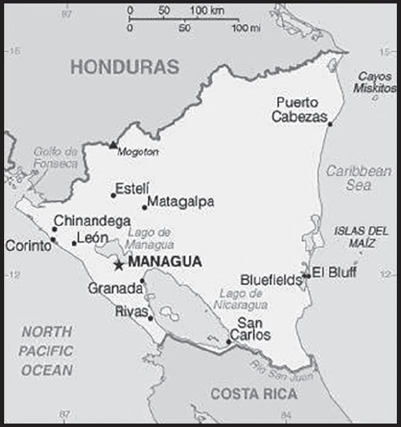
Location: Central America, bordering both the Caribbean Sea and the North Pacific Ocean, between Costa Rica and Honduras
Geographic coordinates: 13 00 N, 85 00 W
Map references: Central America and the Caribbean
Area: total: 130,370 sq km
land: 119,990 sq km
water: 10,380 sq km
comparison ranking: total 98
Area - comparative: slightly larger than Pennsylvania; slightly smaller than New York state
Land boundaries: total: 1,253 km
border countries (2): Costa Rica 313 km; Honduras 940 km
Coastline: 910 km
Maritime claims: territorial sea: 12 nm
contiguous zone: 24 nm
continental shelf: natural prolongation
Climate: tropical in lowlands, cooler in highlands
Terrain: extensive Atlantic coastal plains rising to central interior mountains; narrow Pacific coastal plain interrupted by volcanoes
Elevation: highest point: Mogoton 2,085 m
lowest point: Pacific Ocean 0 m
mean elevation: 298 m
Natural resources: gold, silver, copper, tungsten, lead, zinc, timber, fish
Land use: agricultural land: 42.2% (2018 est.)
arable land: 12.5% (2018 est.)
permanent crops: 2.5% (2018 est.)
permanent pasture: 27.2% (2018 est.)
forest: 25.3% (2018 est.)
other: 32.5% (2018 est.)
Irrigated land: 1,990 sq km (2012)
Major lakes (area sq km): fresh water lake(s): Lago de Nicaragua - 8,150 sq km; Lago de Managua - 1,040 sq km
Population distribution: the overwhelming majority of the population resides in the western half of the country, with much of the urban growth centered in the capital city of Managua; coastal areas also show large population clusters
Natural hazards: destructive earthquakes; volcanoes; landslides; extremely susceptible to hurricanes
volcanism: significant volcanic activity; Cerro Negro (728 m), which last erupted in 1999, is one of Nicaragua’s most active volcanoes; its lava flows and ash have been known to cause significant damage to farmland and buildings; other historically active volcanoes include Concepcion, Cosiguina, Las Pilas, Masaya, Momotombo, San Cristobal, and Telica
Geography - note: largest country in Central America; contains the largest freshwater body in Central America, Lago de Nicaragua
PEOPLE AND SOCIETY
Population: 6,359,689 (2023 est.)
comparison ranking: 110
Nationality: noun: Nicaraguan(s)
adjective: Nicaraguan
Ethnic groups: Mestizo (mixed Amerindian and White) 69%, White 17%, Black 9%, Amerindian 5%
Languages: Spanish (official) 95.3%, Miskito 2.2%, Mestizo of the Caribbean coast 2%, other 0.5%; note - English and indigenous languages found on the Caribbean coast (2005 est.)
major-language sample(s):
La Libreta Informativa del Mundo, la fuente indispensable de información básica. (Spanish)
Religions: Roman Catholic 50%, Evangelical 33.2%, other 2.9%, none 0.7%, unspecified 13.2% (2017 est.)
Demographic profile: Despite being one of the poorest countries in Latin America, Nicaragua has improved its access to potable water and sanitation and has ameliorated its life expectancy, infant and child mortality, and immunization rates. However, income distribution is very uneven, and the poor, agriculturalists, and indigenous people continue to have less access to healthcare services. Nicaragua’s total fertility rate has fallen from around 6 children per woman in 1980 to below replacement level today, but the high birth rate among adolescents perpetuates a cycle of poverty and low educational attainment.
Nicaraguans emigrate primarily to Costa Rica and to a lesser extent the United States. Nicaraguan men have been migrating seasonally to Costa Rica to harvest bananas and coffee since the early 20th century. Political turmoil, civil war, and natural disasters from the 1970s through the 1990s dramatically increased the flow of refugees and permanent migrants seeking jobs, higher wages, and better social and healthcare benefits. Since 2000, Nicaraguan emigration to Costa Rica has slowed and stabilized. Today roughly 300,000 Nicaraguans are permanent residents of Costa Rica - about 75% of the foreign population - and thousands more migrate seasonally for work, many illegally.
Age structure: 0-14 years: 24.16% (male 784,847/female 751,616)
15-64 years: 69.36% (male 2,134,871/female 2,276,522)
65 years and over: 6.48% (2023 est.) (male 180,441/female 231,392)
Dependency ratios: total dependency ratio: 54.4
youth dependency ratio: 46.4
elderly dependency ratio: 8
potential support ratio: 12.6 (2021 est.)
Median age: total: 27.3 years (2020)
male: 26.4 years
female: 28.2 years
comparison ranking: total 147
Population growth rate: 0.91% (2023 est.)
comparison ranking: 100
Birth rate: 16.3 births/1,000 population (2023 est.)
comparison ranking: 95
Death rate: 5.19 deaths/1,000 population (2023 est.)
comparison ranking: 188
Net migration rate: -2.04 migrant(s)/1,000 population (2023 est.)
comparison ranking: 170
Population distribution: the overwhelming majority of the population resides in the western half of the country, with much of the urban growth centered in the capital city of Managua; coastal areas also show large population clusters
Urbanization: urban population: 59.8% of total population (2023)
rate of urbanization: 1.45% annual rate of change (2020-25 est.)
Major urban areas - population: 1.095 million MANAGUA (capital) (2023)
Sex ratio: at birth: 1.05 male(s)/female
0-14 years: 1.04 male(s)/female
15-64 years: 0.94 male(s)/female
65 years and over: 0.78 male(s)/female
total population: 0.95 male(s)/female (2023 est.)
Mother’s mean age at first birth: 19.2 years (2011/12 est.)
note: data represents median age at first birth among women 25-29
Maternal mortality ratio: 78 deaths/100,000 live births (2020 est.)
comparison ranking: 74
Infant mortality rate: total: 18.63 deaths/1,000 live births (2023 est.)
male: 21.7 deaths/1,000 live births
female: 15.4 deaths/1,000 live births
comparison ranking: total 87
Life expectancy at birth: total population: 75.05 years (2023 est.)
male: 72.84 years
female: 77.36 years
comparison ranking: total population 132
Total fertility rate: 1.78 children born/woman (2023 est.)
comparison ranking: 145
Gross reproduction rate: 0.87 (2023 est.)
Contraceptive prevalence rate: 80.4% (2011/12)
Drinking water source: improved: urban: 97.5% of population
rural: 62.6% of population
total: 83.2% of population
unimproved: urban: 2.5% of population
rural: 37.4% of population
total: 16.8% of population (2020 est.)
Current health expenditure: 8.6% of GDP (2020)
Physicians density: 1.67 physicians/1,000 population (2018)
Hospital bed density: 0.9 beds/1,000 population (2017)
Sanitation facility access: improved: urban: 89.9% of population
rural: 66.5% of population
total: 80.3% of population
unimproved: urban: 10.1% of population
rural: 33.5% of population
total: 19.7% of population (2020 est.)
Major infectious diseases: degree of risk: high (2023)
food or waterborne diseases: bacterial diarrhea, hepatitis A, and typhoid fever
vectorborne diseases: dengue fever and malaria
Obesity - adult prevalence rate: 23.7% (2016)
comparison ranking: 63
Alcohol consumption per capita: total: 3.69 liters of pure alcohol (2019 est.)
beer: 1.57 liters of pure alcohol (2019 est.)
wine: 0.02 liters of pure alcohol (2019 est.)
spirits: 2.1 liters of pure alcohol (2019 est.)
other alcohols: 0 liters of pure alcohol (2019 est.)
comparison ranking: total 101
Currently married women (ages 15-49): 56% (2023 est.)
Education expenditures: 4.6% of GDP (2020 est.)
comparison ranking: 96
Literacy: definition: age 15 and over can read and write
total population: 82.6%
male: 82.4%
female: 82.8% (2015)
Youth unemployment rate (ages 15-24): total: 11.6% (2021 est.)
male: 10.2%
female: 15.5%
comparison ranking: total 139
ENVIRONMENT
Environment - current issues: deforestation; soil erosion; water pollution; drought
Environment - international agreements: party to: Biodiversity, Climate Change, Climate Change-Kyoto Protocol, Climate Change-Paris Agreement, Comprehensive Nuclear Test Ban, Desertification, Endangered Species, Environmental Modification, Hazardous Wastes, Law of the Sea, Nuclear Test Ban, Ozone Layer Protection, Ship Pollution, Wetlands, Whaling
signed, but not ratified: none of the selected agreements
Climate: tropical in lowlands, cooler in highlands
Land use: agricultural land: 42.2% (2018 est.)
arable land: 12.5% (2018 est.)
permanent crops: 2.5% (2018 est.)
permanent pasture: 27.2% (2018 est.)
forest: 25.3% (2018 est.)
other: 32.5% (2018 est.)
Urbanization: urban population: 59.8% of total population (2023)
rate of urbanization: 1.45% annual rate of change (2020-25 est.)
Revenue from forest resources: 1.26% of GDP (2018 est.)
comparison ranking: 49
Revenue from coal: 0% of GDP (2018 est.)
comparison ranking: 98
Air pollutants: particulate matter emissions: 16 micrograms per cubic meter (2019 est.)
carbon dioxide emissions: 5.59 megatons (2016 est.)
methane emissions: 6.46 megatons (2020 est.)
Waste and recycling: municipal solid waste generated annually: 1,528,816 tons (2010 est.)
Major lakes (area sq km): fresh water lake(s): Lago de Nicaragua - 8,150 sq km; Lago de Managua - 1,040 sq km
Total water withdrawal: municipal: 286 million cubic meters (2020 est.)
industrial: 50 million cubic meters (2020 est.)
agricultural: 1.08 billion cubic meters (2020 est.)
Total renewable water resources: 164.52 billion cubic meters (2020 est.)
GOVERNMENT
Country name: conventional long form: Republic of Nicaragua
conventional short form: Nicaragua
local long form: República de Nicaragua
local short form: Nicaragua
etymology: Nicarao was the name of the largest indigenous settlement at the time of Spanish arrival; conquistador Gil GONZALEZ Davila, who explored the area (1622-23), combined the name of the community with the Spanish word “agua” (water), referring to the two large lakes in the west of the country (Lake Managua and Lake Nicaragua)
Government type: presidential republic
Capital: name: Managua
geographic coordinates: 12 08 N, 86 15 W
time difference: UTC-6 (1 hour behind Washington, DC, during Standard Time)
etymology: may derive from the indigenous Nahuatl term “mana-ahuac,” which translates as “adjacent to the water” or a site “surrounded by water”; the city is situated on the southwestern shore of Lake Managua
Administrative divisions: 15 departments (departamentos, singular - departamento) and 2 autonomous regions* (regiones autonomistas, singular - region autonoma); Boaco, Carazo, Chinandega, Chontales, Costa Caribe Norte*, Costa Caribe Sur*, Esteli, Granada, Jinotega, Leon, Madriz, Managua, Masaya, Matagalpa, Nueva Segovia, Rio San Juan, Rivas
Independence: 15 September 1821 (from Spain)
National holiday: Independence Day, 15 September (1821)
Constitution: history: several previous; latest adopted 19 November 1986, effective 9 January 1987
amendments: proposed by the president of the republic or assent of at least half of the National Assembly membership; passage requires approval by 60% of the membership of the next elected Assembly and promulgation by the president of the republic; amended several times, last in 2021
Legal system: civil law system; Supreme Court may review administrative acts
International law organization participation: accepts compulsory ICJ jurisdiction with reservations; non-party state to the ICCt
Citizenship: citizenship by birth: yes
citizenship by descent only: yes
dual citizenship recognized: no, except in cases where bilateral agreements exist
residency requirement for naturalization: 4 years
Suffrage: 16 years of age; universal
Executive branch: chief of state: President Jose Daniel ORTEGA Saavedra (since 10 January 2007); Vice President Rosario MURILLO Zambrana (since 10 January 2017); note - the president is both chief of state and head of government
head of government: President Jose Daniel ORTEGA Saavedra (since 10 January 2007); Vice President Rosario MURILLO Zambrana (since 10 January 2017)
cabinet: Council of Ministers appointed by the president
elections/appointments: president and vice president directly elected on the same ballot by qualified plurality vote for a 5-year term (no term limits); election last held on 7 November 2021 (next to be held on 1 November 2026)
election results:
2021: Jose Daniel ORTEGA Saavedra reelected president for a fourth consecutive term; percent of vote - Jose Daniel ORTEGA Saavedra (FSLN) 75.9%, Walter ESPINOZA (PLC) 14.3%, Guillermo OSORNO (CCN) 3.3%, Marcelo MONTIEL (ALN) 3.1%, other 3.4%
2016: Jose Daniel ORTEGA Saavedra reelected president for a third consecutive term; percent of vote - Jose Daniel ORTEGA Saavedra (FSLN) 72.4%, Maximino RODRIGUEZ (PLC) 15%, Jose del Carmen ALVARADO (PLI) 4.5%, Saturnino CERRATO Hodgson (ALN) 4.3%, other 3.7%
Legislative branch: description: unicameral National Assembly or Asamblea Nacional (92 statutory seats, current 91; 70 members in multiseat constituencies, representing the country’s 15 departments and 2 autonomous regions, and 20 members in a single nationwide constituency directly elected by party-list proportional representation vote; up to 2 seats reserved for the previous president and the runner-up candidate in the previous presidential election; members serve 5-year terms)
elections: last held on 7 November 2021 (next to be held on 1 November 2026)
election results: percent of vote by party - NA; seats by party - FSLN 75, PLC 10, ALN 2, APRE 1, PLI 2, YATAMA 1; composition - men 45, women 46, percent of women 50.6%
Judicial branch: highest court(s): Supreme Court or Corte Suprema de Justicia (consists of 16 judges organized into administrative, civil, criminal, and constitutional chambers)
judge selection and term of office: Supreme Court judges elected by the National Assembly to serve 5-year staggered terms
subordinate courts: Appeals Court; first instance civil, criminal, and labor courts; military courts are independent of the Supreme Court
Political parties and leaders: Alliance for the Republic or APRE [Carlos CANALES]
Alternative for Change or AC (operates in a political alliance with the FSLN) [Orlando Jose TARDENCILLA]
Autonomous Liberal Party or PAL [Rene Margarito BELLO ROMERO]
Caribbean Unity Movement or PAMUC [Armando Francisco ARISTA FLORES]
Christian Unity Party or PUC (operates in a political alliance with the FSLN) [Guillermo Daniel ORTEGA REYES]
Citizens for Liberty or CxL [Carmella ROGERS AUMBURN]; note - barred from participating in the presidential election by the Supreme Electoral Council on 6 August 2021
Conservative Party or PC [Alfredo CESAR Aguirre]
Democratic Restoration Party or PRD [Saturnino CERRATO]; note - canceled by the Supreme Electoral Council on 18 May 2021
Independent Liberal Party or PLI [Mario ASENSIO]
Liberal Constitutionalist Party or PLC [Maria Haydee OSUNA]
Moskitia Indigenous Progressive Movement or MOSKITIA PAWANKA (operates in a political alliance with the FSLN) [Wycliff Diego BLANDON]
Multiethnic Indigenous Party or PIM (operates in a political alliance with the FSLN) [Carla Elvis WHITE HODGSON]
Nationalist Liberal Party or PLN (operates in a political alliance with the FSLN) [Constantino Raul VELASQUEZ]
Nicaraguan Liberal Alliance or ALN [Alejandro MEJIA Ferreti]
Nicaraguan Party of the Christian Path or CCN [Guillermo OSORNO]
Nicaraguan Resistance Party or PRN (operates in a political alliance with the FSLN) [Julio Cesar BLANDON SANCHEZ]
Sandinista National Liberation Front or FSLN [Jose Daniel ORTEGA Saavedra]
Sandinista Renovation Movement or MRS [Suyen BARAHONA Cuan]; note - canceled by the Supreme Electoral Council on 21 June 2008; in January 2021, they rebranded and now call themselves Democratic Renovation Union or UNAMOS Sons of Mother Earth or YATAMA [Brooklyn RIVERA]
The New Sons of Mother Earth Movement or MYATAMARAN (operates in a political alliance with the FSLN) [Osorno Salomon COLEMAN]
International organization participation: BCIE, CACM, CD, CELAC, FAO, G-77, IADB, IAEA, IBRD, ICAO, ICRM, IDA, IFAD, IFC, IFRCS, ILO, IMF, IMO, Interpol, IOC, IOM, IPU, ISO (correspondent), ITSO, ITU, ITUC (NGOs), LAES, LAIA (observer), MIGA, NAM, OAS, OPANAL, OPCW, PCA, Petrocaribe, SICA, UN, UNCTAD, UNESCO, UNHCR, UNIDO, Union Latina, UNWTO, UPU, WCO, WHO, WIPO, WMO, WTO
Diplomatic representation in the US: chief of mission: Ambassador Francisco Obadiah CAMPBELL Hooker (since 28 June 2010)
chancery: 1627 New Hampshire Avenue NW, Washington, DC 20009
telephone: [1] (202) 939-6570
FAX: [1] (202) 939-6545
email address and website:
consulate(s) general: Houston, Los Angeles, Miami, New York, San Francisco
Diplomatic representation from the US: chief of mission: Ambassador (vacant); Chargé d’Affaires Kevin Michael O’REILLY (since 28 June 2023)
embassy: Kilometer 5.5 Carretera Sur, Managua
mailing address: 3240 Managua Place, Washington DC 20521-3240
telephone: [505] 2252-7100,
FAX: [505] 2252-7250
email address and website:
Flag description: three equal horizontal bands of blue (top), white, and blue with the national coat of arms centered in the white band; the coat of arms features a triangle encircled by the words REPUBLICA DE NICARAGUA on the top and AMERICA CENTRAL on the bottom; the banner is based on the former blue-white-blue flag of the Federal Republic of Central America; the blue bands symbolize the Pacific Ocean and the Caribbean Sea, while the white band represents the land between the two bodies of water
note: similar to the flag of El Salvador, which features a round emblem encircled by the words REPUBLICA DE EL SALVADOR EN LA AMERICA CENTRAL centered in the white band; also similar to the flag of Honduras, which has five blue stars arranged in an X pattern centered in the white band
National symbol(s): turquoise-browed motmot (bird); national colors: blue, white
National anthem: name: “Salve a ti, Nicaragua” (Hail to Thee, Nicaragua)
lyrics/music: Salomon Ibarra MAYORGA/traditional, arranged by Luis Abraham DELGADILLO
note: although only officially adopted in 1971, the music was approved in 1918 and the lyrics in 1939; the tune, originally from Spain, was used as an anthem for Nicaragua from the 1830s until 1876
National heritage: total World Heritage Sites: 2 (both cultural)
selected World Heritage Site locales: Ruins of León Viejo; León Cathedral
ECONOMY
Economic overview: low-income Central American economy; until 2018, nearly 20 years of sustained GDP growth; recent struggles due to COVID-19, political instability, and hurricanes; significant remittances; increasing poverty and food scarcity since 2005; sanctions limit investment
Real GDP (purchasing power parity): $38.628 billion (2021 est.)
$35.007 billion (2020 est.)
$35.645 billion (2019 est.)
note: data are in 2017 dollars
comparison ranking: 125
Real GDP growth rate: 10.34% (2021 est.)
-1.79% (2020 est.)
-3.78% (2019 est.)
comparison ranking: 28
Real GDP per capita: $5,600 (2021 est.)
$5,200 (2020 est.)
$5,300 (2019 est.)
note: data are in 2017 dollars
comparison ranking: 168
GDP (official exchange rate): $12.57 billion (2019 est.)
Inflation rate (consumer prices): 4.93% (2021 est.)
3.68% (2020 est.)
5.38% (2019 est.)
comparison ranking: 69
Credit ratings: Fitch rating: B- (2018)
Moody’s rating: B3 (2020)
Standard & Poors rating: B- (2018)
note: The year refers to the year in which the current credit rating was first obtained.
GDP - composition, by sector of origin: agriculture: 15.5% (2017 est.)
industry: 24.4% (2017 est.)
services: 60% (2017 est.)
comparison rankings: services 126; industry 113; agriculture 62
GDP - composition, by end use: household consumption: 69.9% (2017 est.)
government consumption: 15.3% (2017 est.)
investment in fixed capital: 28.1% (2017 est.)
investment in inventories: 1.7% (2017 est.)
exports of goods and services: 41.2% (2017 est.)
imports of goods and services: -55.4% (2017 est.)
Agricultural products: sugar cane, milk, rice, maize, plantains, groundnuts, cassava, beans, coffee, poultry
Industries: food processing, chemicals, machinery and metal products, knit and woven apparel, petroleum refining and distribution, beverages, footwear, wood, electric wire harness manufacturing, mining
Industrial production growth rate: 21.28% (2021 est.)
comparison ranking: 4
Labor force: 3.042 million (2021 est.)
comparison ranking: 106
Labor force - by occupation: agriculture: 31%
industry: 18%
services: 50% (2011 est.)
Unemployment rate: 5.96% (2021 est.)
6.08% (2020 est.)
5.21% (2019 est.)
note: underemployment was 46.5% in 2008
comparison ranking: 130
Youth unemployment rate (ages 15-24): total: 11.6% (2021 est.)
male: 10.2%
female: 15.5%
comparison ranking: total 139
Population below poverty line: 24.9% (2016 est.)
Gini Index coefficient - distribution of family income: 46.2 (2014 est.)
comparison ranking: 22
Household income or consumption by percentage share: lowest 10%: 1.8%
highest 10%: 47.1% (2014)
Budget: revenues: $3.452 billion (2019 est.)
expenditures: $3.511 billion (2019 est.)
Budget surplus (+) or deficit (-): -2% (of GDP) (2017 est.)
comparison ranking: 102
Public debt: 33.3% of GDP (2017 est.)
31.2% of GDP (2016 est.)
note: official data; data cover general government debt and include debt instruments issued (or owned) by Government entities other than the treasury; the data include treasury debt held by foreign entities, as well as intragovernmental debt; intragovernmental debt consists of treasury borrowings from surpluses in the social funds, such as retirement, medical care, and unemployment, debt instruments for the social funds are not sold at public auctions; Nicaragua rebased its GDP figures in 2012, which reduced the figures for debt as a percentage of GDP
comparison ranking: 160
Taxes and other revenues: 17.2% (of GDP) (2020 est.)
comparison ranking: 117
Fiscal year: calendar year
Current account balance: -$316.6 million (2021 est.)
$496.7 million (2020 est.)
$754.1 million (2019 est.)
comparison ranking: 109
Exports: $6.617 billion (2021 est.) note: data are in current year dollars
$5.342 billion (2020 est.) note: data are in current year dollars
$5.714 billion (2019 est.) note: data are in current year dollars
comparison ranking: 120
Exports - partners: United States 60%, El Salvador 5%, Mexico 5% (2019)
Exports - commodities: clothing and apparel, gold, insulated wiring, coffee, beef, cigars (2021)
Imports: $8.306 billion (2021 est.) note: data are in current year dollars
$5.939 billion (2020 est.) note: data are in current year dollars
$6.252 billion (2019 est.) note: data are in current year dollars
comparison ranking: 123
Imports - partners: United States 27%, Mexico 12%, China 11%, Guatemala 9%, Costa Rica 7%, El Salvador 6%, Honduras 6% (2019)
Imports - commodities: refined petroleum, clothing and apparel, crude petroleum, packaged medicines, insulated wiring (2019)
Reserves of foreign exchange and gold: $4.047 billion (31 December 2021 est.)
$3.212 billion (31 December 2020 est.)
$2.397 billion (31 December 2019 est.)
comparison ranking: 109
Debt - external: $11.674 billion (2019 est.)
$11.771 billion (2018 est.)
comparison ranking: 108
Exchange rates: cordobas (NIO) per US dollar -
Exchange rates: 35.171 (2021 est.)
34.342 (2020 est.)
33.122 (2019 est.)
31.553 (2018 est.)
30.051 (2017 est.)
ENERGY
Electricity access: population without electricity: (2020) less than 1 million
electrification - total population: 86.2% (2021)
electrification - urban areas: 100% (2021)
electrification - rural areas: 66.3% (2021)
Electricity: installed generating capacity: 1.837 million kW (2020 est.)
consumption: 3,182,620,000 kWh (2019 est.)
exports: 0 kWh (2019 est.)
imports: 434 million kWh (2019 est.)
transmission/distribution losses: 1.89 billion kWh (2019 est.)
comparison rankings: installed generating capacity 122; transmission/distribution losses 89; imports 91; exports 187; consumption 137
Electricity generation sources: fossil fuels: 37.8% of total installed capacity (2020 est.)
solar: 0.5% of total installed capacity (2020 est.)
wind: 15.7% of total installed capacity (2020 est.)
hydroelectricity: 12.2% of total installed capacity (2020 est.)
geothermal: 16.7% of total installed capacity (2020 est.)
biomass and waste: 17.2% of total installed capacity (2020 est.)
Petroleum: total petroleum production: 200 bbl/day (2021 est.)
refined petroleum consumption: 35,100 bbl/day (2019 est.)
crude oil and lease condensate exports: 0 bbl/day (2018 est.)
crude oil and lease condensate imports: 13,000 bbl/day (2018 est.)
crude oil estimated reserves: 0 barrels (2021 est.)
Refined petroleum products - production: 14,720 bbl/day (2015 est.)
comparison ranking: 95
Refined petroleum products - exports: 460 bbl/day (2015 est.)
comparison ranking: 111
Refined petroleum products - imports: 20,120 bbl/day (2015 est.)
comparison ranking: 121
Carbon dioxide emissions: 4.851 million metric tonnes of CO2 (2019 est.)
from petroleum and other liquids: 4.851 million metric tonnes of CO2 (2019 est.)
comparison ranking: total emissions 136
Energy consumption per capita: 14.916 million Btu/person (2019 est.)
comparison ranking: 141
COMMUNICATIONS
Telephones - fixed lines: total subscriptions: 207,577 (2021 est.)
subscriptions per 100 inhabitants: 3 (2021 est.)
comparison ranking: total subscriptions 119
Telephones - mobile cellular: total subscriptions: 6,233,864 (2021 est.)
subscriptions per 100 inhabitants: 91 (2021 est.)
comparison ranking: total subscriptions 115
Telecommunication systems: general assessment: Nicaragua’s telecoms market has mirrored the country’s poor economic achievements, with fixed-line teledensity and mobile penetration also being the lowest in Central America; the fixed line broadband market remains nascent, with population penetration below 4%; most internet users are concentrated in the largest cities, given that rural and marginal areas lack access to the most basic telecom infrastructure; internet cafés provide public access to internet and email services, but these also tend to be restricted to the larger population centers; to address poor infrastructure, the World Bank has funded a project aimed at improving connectivity via a national fiber broadband network; there are separate schemes to improve broadband in eastern regions and provide links to Caribbean submarine cables; the number of mobile subscribers overtook the number of fixed lines in early 2002, and the mobile sector now accounts for most lines in service (2021)
domestic: fixed-line teledensity is 3 per 100 persons; mobile-cellular telephone subscribership is 91 per 100 persons (2021)
international: country code - 505; landing point for the ARCOS fiber-optic submarine cable which provides connectivity to South and Central America, parts of the Caribbean, and the US; satellite earth stations - 1 Intersputnik (Atlantic Ocean region) and 1 Intelsat (Atlantic Ocean) (2019)
Broadcast media: multiple terrestrial TV stations, supplemented by cable TV in most urban areas; nearly all are government-owned or affiliated; more than 300 radio stations, both government-affiliated and privately owned (2019)
Internet country code: .ni
Internet users: total: 3.933 million (2021 est.)
percent of population: 57% (2021 est.)
comparison ranking: total 111
Broadband - fixed subscriptions: total: 290,351 (2020 est.)
subscriptions per 100 inhabitants: 4 (2020 est.)
comparison ranking: total 108
TRANSPORTATION
National air transport system: number of registered air carriers: 1 (2020)
inventory of registered aircraft operated by air carriers: 7
Civil aircraft registration country code prefix: YN
Airports: 147 (2021)
comparison ranking: total 38
Airports - with paved runways: 12
note: paved runways have a concrete or asphalt surface but not all have facilities for refueling, maintenance, or air traffic control; the length of a runway required for aircraft to safely operate depends on a number of factors including the type of aircraft, the takeoff weight (including passengers, cargo, and fuel), engine types, flap settings, landing speed, elevation of the airport, and average maximum daily air temperature; paved runways can reach a length of 5,000 m (16,000 ft.), but the “typical” length of a commercial airline runway is between 2,500-4,000 m (8,000-13,000 ft.)
Airports - with unpaved runways: 135
note: unpaved runways have a surface composition such as grass or packed earth and are most suited to the operation of light aircraft; unpaved runways are usually short, often less than 1,000 m (3,280 ft.) in length; airports with unpaved runways often lack facilities for refueling, maintenance, or air traffic control
Pipelines: 54 km oil (2013)
Roadways: total: 23,897 km (2014)
paved: 3,346 km (2014)
unpaved: 20,551 km (2014)
comparison ranking: total 106
Waterways: 2,220 km (2011) (navigable waterways as well as the use of the large Lake Managua and Lake Nicaragua; rivers serve only the sparsely populated eastern part of the country)
comparison ranking: 41
Merchant marine: total: 5 (2022)
by type: general cargo 1, oil tanker 1, other 3
comparison ranking: total 166
Ports and terminals: major seaport(s): Bluefields, Corinto
MILITARY AND SECURITY
Military and security forces: Armed Forces of Nicaragua (formal name is Army of Nicaragua or Ejercito de Nicaragua, EN): Land Forces (Fuerza Terrestre); Naval Forces (Fuerza Naval); Air Forces (Fuerza Aérea) (2023)
note: both the military and the Nicaraguan National Police (Policía Nacional de Nicaragua or PNN) report directly to the president; Parapolice, which are nonuniformed, armed, and masked units with marginal tactical training and loose hierarchical organization, act in coordination with government security forces and report directly to the National Police; they have been used to suppress anti-government protesters
Military expenditures: 0.6% of GDP (2022 est.)
0.6% of GDP (2021 est.)
0.6% of GDP (2020 est.)
0.6% of GDP (2019 est.)
0.6% of GDP (2018 est.)
comparison ranking: 151
Military and security service personnel strengths: approximately 12,000 active personnel (10,000 Army; 800 Navy; 1,200 Air Force) (2023)
Military equipment inventories and acquisitions: the military’s inventory includes mostly secondhand Russian/Soviet-era equipment; in recent years, Russia has been the leading arms supplier to Nicaragua (2023)
Military service age and obligation: 18-30 years of age for voluntary military service; no conscription; tour of duty 18-36 months (2023)
Military - note: the military is responsible for defending Nicaragua’s independence, sovereignty, and territory, but also has some domestic security responsibilities; key tasks include border security, assisting the police, protecting natural resources, and providing disaster relief and humanitarian assistance; it has ties with the militaries of Cuba, Venezuela, and Russia; Russia has provided training support and equipment
the military’s Land Forces have a mechanized brigade and approximately 8 regional commands or detachments, each with 1 or more light infantry battalions; there is also a small special operations command; the Naval Forces operate patrol boats and have a naval infantry battalion; the Air Forces do not possess any combat aircraft
the modern Army of Nicaragua was created in 1979 as the Sandinista Popular Army (1979-1984); prior to 1979, the military was known as the National Guard, which was organized and trained by the US in the 1920s and 1930s; the first commander of the National Guard, Anastasio SOMOZA GARCIA, seized power in 1937 and ran the country as a military dictator until his assassination in 1956; his sons ran the country either directly or through figureheads until the Sandinistas came to power in 1979; the defeated National Guard was disbanded by the Sandinistas (2023)
SPACE
Space agency/agencies: National Secretariat for Extraterrestrial Space Affairs, The Moon and Other Celestial Bodies (Secretaría Nacional para Asuntos del Espacio Ultraterrestre, la Luna y otros Cuerpos Celestes, established 2021; operates under the military’s control) (2023)
Space program overview: stated mission of the space agency is to promote the development of space activities with the aim of broadening the country’s capacities in the fields of education, industry, science, and technology; has cooperated with China and Russia; is a signatory of the convention establishing the Latin American and Caribbean Space Agency (ALCE) (2023)
note: further details about the key activities, programs, and milestones of the country’s space program, as well as government spending estimates on the space sector, appear in Appendix S
TRANSNATIONAL ISSUES
Disputes - international: Nicaragua-El Salvador-Honduras: the 1992 ICJ ruling for El Salvador and Honduras advised a tripartite resolution to establish a maritime boundary in the Gulf of Fonseca, which considers Honduran access to the Pacific; the court ruled, rather, that the Gulf of Fonseca represents a condominium, with control being shared by El Salvador, Honduras, and Nicaragua; the decision allowed for the possibility that the three nations could divide the waters at a later date if they wished to do so
Nicaragua-Costa Rica: Nicaragua and Costa Rica regularly file border dispute cases with the ICJ over the delimitations of the San Juan River and the northern tip of Calero Island, virtually uninhabited areas claimed by both countries; there is an ongoing case in the ICJ to determine Pacific and Atlantic ocean maritime borders as well as land borders; in 2009, the ICJ ruled that Costa Rican vessels carrying out police activities could not use the river, but official Costa Rican vessels providing essential services to riverside inhabitants and Costa Rican tourists could travel freely on the river; in 2011, the ICJ provisionally ruled that both countries must remove personnel from the disputed area; in 2013, the ICJ rejected Nicaragua’s 2012 suit to halt Costa Rica’s construction of a highway paralleling the river on the grounds of irreparable environmental damage; in 2013, the ICJ, regarding the disputed territory, ordered that Nicaragua should refrain from dredging or canal construction and refill and repair damage caused by trenches connecting the river to the Caribbean and upheld its 2010 ruling that Nicaragua must remove all personnel; in early 2014, Costa Rica brought Nicaragua to the ICJ over offshore oil concessions in the disputed region; in 2018, the ICJ ruled that Nicaragua must remove a military base from a contested coastal area near the San Juan River, and that Costa Rica had sovereignty over the northern part of Isla Portillos, including the coast, but excluding Harbour Head Lagoon; additionally, Honduras was required to pay reparations for environmental damage to part of the wetlands at the mouth of the San Juan River
Nicaragua-Colombia: Nicaragua filed a case with the International Court of Justice (ICJ) against Colombia in 2013 over the delimitation of the Continental shelf beyond the 200 nautical miles from the Nicaraguan coast, as well as over the alleged violation by Colombia of Nicaraguan maritime space in the Caribbean Sea, which contains rich oil and fish resources; as of September 2021, Colombia refuses to abide by the ICJ ruling
Nicaragua-Honduras: none identified
Trafficking in persons: tier rating: Tier 3 — Nicaragua does not fully meet the minimum standards for the elimination of trafficking and is not making significant efforts to do so; the government took some steps to address trafficking, prosecuting eight alleged traffickers and convicting four sex traffickers; however, the government continued to downplay the severity of the trafficking problem, denying that traffickers exploited Nicaraguans in foreign countries; officials did not report any investigations, prosecutions, or convictions of government employees, despite endemic corruption and widespread official complicity; the government did not cooperate with NGOs and civil society in a national anti-trafficking coalition seeking to identify and provide services to victims (2022)
trafficking profile: human traffickers exploit domestic and foreign victims in Nicaragua and Nicaraguans abroad; women, children, and migrants are most at risk; women and children are subject to sex trafficking within the country and its two Caribbean autonomous regions, as well as in other Central American countries, Mexico, Spain, and the United States; traffickers used social media to recruit victims with promises of higher-paying jobs in restaurants, hotels, domestic service, construction, and security outside of Nicaragua where they are subjected to sex or labor trafficking; traffickers force children to participate in illegal drug production and trafficking, while others are forced to work in artisanal mines and quarries; children and persons with disabilities are subjected to forced begging; Nicaragua is a destination for child sex tourists from the United States, Canada, and Western Europe (2022)
Illicit drugs: transit route for illicit drugs originating from South America destined for the United States
NIGER
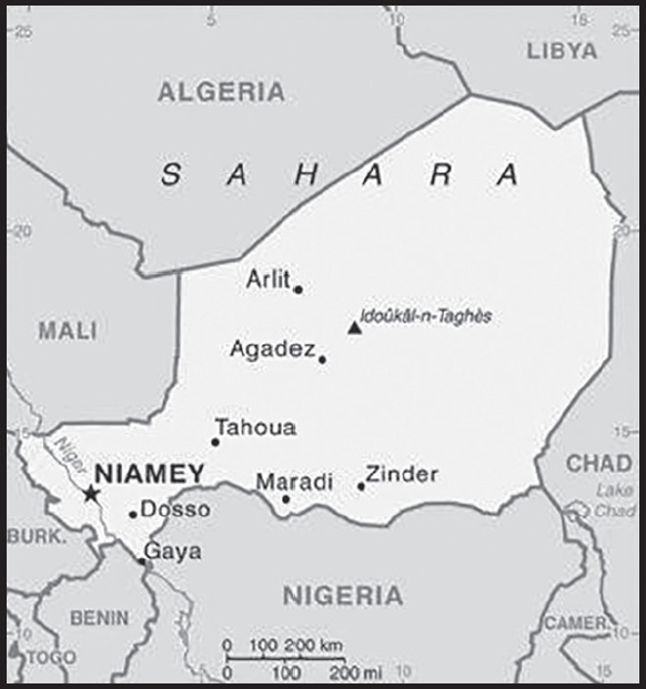
INTRODUCTION
Background: Present-day Niger originated from the nomadic peoples of the Saharan north and the agriculturalists of the south. The Taureg kingdom of Takedda was one of the largest kingdoms in the north and played a prominent role in regional trade in the 14th century. In the south, the primary ethnic groups were the Songhai-Zarma in the west, the Hausa in the center, and the Kanuri in the east. When European colonizers arrived in the 19th century, the region was an assemblage of disparate local kingdoms.
In the late 19th century, the British and French agreed to partition the middle regions of the Niger River, and France began its conquest of what would become the colony of Niger. France experienced determined local resistance - particularly during the Tuareg uprising (1916-1917) - but established a colonial administration in 1922.
After achieving independence from France in 1960, Niger experienced single-party or military rule until 1991 when political pressure forced General Ali SAIBOU to allow multiparty elections. Political infighting and democratic backsliding led to coups in 1996 and 1999. In December of that year, military officers restored democratic rule and held elections that brought Mamadou TANDJA to power. TANDJA was reelected in 2004 and spearheaded a 2009 constitutional amendment allowing him to extend his presidential term. In February 2010, military officers led another coup that deposed TANDJA. ISSOUFOU Mahamadou was elected in April 2011 and reelected in early 2016. In February 2021, BAZOUM Mohammed won the presidential election, marking Niger’s first transition from one democratically elected president to another. Nonetheless, a military junta once again seized power in a late-July 2023 coup, detaining President BAZOUM, and announcing the creation of a National Council for the Salvation of the Homeland.
Niger is one of the poorest countries in the world with minimal government services and insufficient funds to develop its resource base. It is ranked last in the world on the UN Development Program’s Human Development Index. The largely agrarian and subsistence-based economy is frequently disrupted by extended droughts common to the Sahel region of Africa. The Nigerien Government continues its attempts to diversify the economy through increased oil production and mining projects. In addition, Niger is facing increased security concerns on its borders from various external threats including insecurity in Libya, spillover from the conflict and terrorism in Mali, and violent extremism in northeastern Nigeria.
GEOGRAPHY
Location: Western Africa, southeast of Algeria
Geographic coordinates: 16 00 N, 8 00 E
Map references: Africa
Area: total: 1.267 million sq km
land: 1,266,700 sq km
water: 300 sq km
comparison ranking: total 23
Area - comparative: slightly less than twice the size of Texas
Land boundaries: total: 5,834 km
border countries (7): Algeria 951 km; Benin 277 km; Burkina Faso 622 km; Chad 1,196 km; Libya 342 km; Mali 838 km;
Nigeria 1,608 km
Coastline: 0 km (landlocked)
Maritime claims: none (landlocked)
Climate: desert; mostly hot, dry, dusty; tropical in extreme south
Terrain: predominately desert plains and sand dunes; flat to rolling plains in south; hills in north
Elevation: highest point: Idoukal-n-Taghes 2,022 m
lowest point: Niger River 200 m
mean elevation: 474 m
Natural resources: uranium, coal, iron ore, tin, phosphates, gold, molybdenum, gypsum, salt, petroleum
Land use: agricultural land: 35.1% (2018 est.)
arable land: 12.3% (2018 est.)
permanent crops: 0.1% (2018 est.)
permanent pasture: 22.7% (2018 est.)
forest: 1% (2018 est.)
other: 63.9% (2018 est.)
Irrigated land: 2,666 sq km (2020)
Major lakes (area sq km): fresh water lake(s): Lake Chad (endorheic lake shared with Chad, Nigeria, and Cameroon) - 10,360-25,900 sq km
note - area varies by season and year to year
Major rivers (by length in km): Niger (shared with Guinea [s], Mali, Benin, and Nigeria [m]) - 4,200 km
note – [s] after country name indicates river source; [m] after country name indicates river mouth
Major watersheds (area sq km): Atlantic Ocean drainage: Niger (2,261,741 sq km)
Internal (endorheic basin) drainage: Lake Chad (2,497,738 sq km)
Major aquifers: Lake Chad Basin, Lullemeden-Irhazer Basin, Murzuk-Djado Basin
Population distribution: majority of the populace is located in the southernmost extreme of the country along the border with Nigeria and Benin as shown in this population distribution map
Natural hazards: recurring droughts
Geography - note: landlocked; one of the hottest countries in the world; northern four-fifths is desert, southern one-fifth is savanna, suitable for livestock and limited agriculture
PEOPLE AND SOCIETY
Population: 25,396,840 (2023 est.)
comparison ranking: 56
Nationality: noun: Nigerien(s)
adjective: Nigerien
Ethnic groups: Hausa 53.1%, Zarma/Songhai 21.2%, Tuareg 11%, Fulani (Peuhl) 6.5%, Kanuri 5.9%, Gurma 0.8%, Arab 0.4%, Tubu 0.4%, other/unavailable 0.9% (2006 est.)
Languages: French (official), Hausa, Djerma
Religions: Muslim 99.3%, Christian 0.3%, animist 0.2%, none 0.1% (2012 est.)
Demographic profile: Niger has the highest total fertility rate (TFR) of any country in the world, averaging close to 7 children per woman in 2022. A slight decline in fertility over the last few decades has stalled. This leveling off of the high fertility rate is in large part a product of the continued desire for large families. In Niger, the TFR is lower than the desired fertility rate, which makes it unlikely that contraceptive use will increase. The high TFR sustains rapid population growth and a large youth population – almost 70% of the populace is under the age of 25, as of 2020. Gender inequality, including a lack of educational opportunities for women and early marriage and childbirth, also contributes to high population growth.
Because of large family sizes, children are inheriting smaller and smaller parcels of land. The dependence of most Nigeriens on subsistence farming on increasingly small landholdings, coupled with declining rainfall and the resultant shrinkage of arable land, are all preventing food production from keeping up with population growth.
For more than half a century, Niger’s lack of economic development has led to steady net outmigration. In the 1960s, Nigeriens mainly migrated to coastal West African countries to work on a seasonal basis. Some headed to Libya and Algeria in the 1970s to work in the booming oil industry until its decline in the 1980s. Since the 1990s, the principal destinations for Nigerien labor migrants have been West African countries, especially Burkina Faso and Cote d’Ivoire, while emigration to Europe and North America has remained modest. During the same period, Niger’s desert trade route town Agadez became a hub for West African and other Sub-Saharan migrants crossing the Sahara to North Africa and sometimes onward to Europe.
More than 60,000 Malian refugees have fled to Niger since violence between Malian government troops and armed rebels began in early 2012. Ongoing attacks by the Boko Haram Islamist insurgency, dating to 2013 in northern Nigeria and February 2015 in southeastern Niger, pushed tens of thousands of Nigerian refugees and Nigerien returnees across the border to Niger and displaced thousands of locals in Niger’s already impoverished Diffa region.
Age structure: 0-14 years: 49.7% (male 6,360,952/female 6,261,000)
15-64 years: 47.6% (male 5,896,312/female 6,192,116)
65 years and over: 2.7% (2023 est.) (male 329,421/female 357,039)
Dependency ratios: total dependency ratio: 105.4
youth dependency ratio: 100.4
elderly dependency ratio: 5
potential support ratio: 20.1 (2021 est.)
Median age: total: 14.8 years (2020)
male: 14.5 years
female: 15.1 years
comparison ranking: total 227
Population growth rate: 3.66% (2023 est.)
comparison ranking: 3
Birth rate: 46.86 births/1,000 population (2023 est.)
comparison ranking: 1
Death rate: 9.66 deaths/1,000 population (2023 est.)
comparison ranking: 38
Net migration rate: -0.62 migrant(s)/1,000 population (2023 est.)
comparison ranking: 129
Population distribution: majority of the populace is located in the southernmost extreme of the country along the border with Nigeria and Benin as shown in this population distribution map
Urbanization: urban population: 17.1% of total population (2023)
rate of urbanization: 4.72% annual rate of change (2020-25 est.)
Major urban areas - population: 1.437 million NIAMEY (capital) (2023)
Sex ratio: at birth: 1.03 male(s)/female
0-14 years: 1.02 male(s)/female
15-64 years: 0.95 male(s)/female
65 years and over: 0.92 male(s)/female
total population: 0.98 male(s)/female (2023 est.)
Mother’s mean age at first birth: 18.5 years (2012 est.)
note: data represents median age at first birth among women 20-49
Maternal mortality ratio: 441 deaths/100,000 live births (2020 est.)
comparison ranking: 19
Infant mortality rate: total: 65.53 deaths/1,000 live births (2023 est.)
male: 70.46 deaths/1,000 live births
female: 60.46 deaths/1,000 live births
comparison ranking: total 6
Life expectancy at birth: total population: 60.48 years (2023 est.)
male: 58.91 years
female: 62.1 years
comparison ranking: total population 218
Total fertility rate: 6.73 children born/woman (2023 est.)
comparison ranking: 1
Gross reproduction rate: 3.31 (2023 est.)
Contraceptive prevalence rate: 11% (2021)
Drinking water source: improved: urban: 95.8% of population
rural: 63.1% of population
total: 68.6% of population
unimproved: urban: 4.2% of population
rural: 36.9% of population
total: 31.4% of population (2020 est.)
Current health expenditure: 6.2% of GDP (2020)
Physicians density: 0.04 physicians/1,000 population (2020)
Hospital bed density: 0.4 beds/1,000 population (2017)
Sanitation facility access: improved: urban: 81.9% of population
rural: 13.5% of population
total: 24.8% of population
unimproved: urban: 18.1% of population
rural: 86.5% of population
total: 75.2% of population (2020 est.)
Major infectious diseases: degree of risk: very high (2023)
food or waterborne diseases: bacterial and protozoal diarrhea, hepatitis A, and typhoid fever
vectorborne diseases: malaria and dengue fever
water contact diseases: schistosomiasis
animal contact diseases: rabies
respiratory diseases: meningococcal meningitis
note: on 31 August 2023, the US Centers for Disease Control and Prevention (CDC) issued a Travel Alert for polio in Africa; Niger is currently considered a high risk to travelers for circulating vaccine-derived polioviruses (cVDPV); vaccine-derived poliovirus (VDPV) is a strain of the weakened poliovirus that was initially included in oral polio vaccine (OPV) and that has changed over time and behaves more like the wild or naturally occurring virus; this means it can be spread more easily to people who are unvaccinated against polio and who come in contact with the stool or respiratory secretions, such as from a sneeze, of an “infected” person who received oral polio vaccine; the CDC recommends that before any international travel, anyone unvaccinated, incompletely vaccinated, or with an unknown polio vaccination status should complete the routine polio vaccine series; before travel to any high-risk destination, the CDC recommends that adults who previously completed the full, routine polio vaccine series receive a single, lifetime booster dose of polio vaccine
Obesity - adult prevalence rate: 5.5% (2016)
comparison ranking: 176
Alcohol consumption per capita: total: 0.11 liters of pure alcohol (2019 est.)
beer: 0.04 liters of pure alcohol (2019 est.)
wine: 0.01 liters of pure alcohol (2019 est.)
spirits: 0.06 liters of pure alcohol (2019 est.)
other alcohols: 0 liters of pure alcohol (2019 est.)
comparison ranking: total 177
Tobacco use: total: 7.4% (2020 est.)
male: 13.7% (2020 est.)
female: 1.1% (2020 est.)
comparison ranking: total 154
Children under the age of 5 years underweight: 34.6% (2022)
comparison ranking: 2
Currently married women (ages 15-49): 80.3% (2023 est.)
Education expenditures: 3.8% of GDP (2020 est.)
comparison ranking: 125
Literacy: definition: age 15 and over can read and write
total population: 37.3%
male: 45.8%
female: 29% (2018)
School life expectancy (primary to tertiary education): total: 6 years
male: 7 years
female: 6 years (2017)
Youth unemployment rate (ages 15-24): total: 1% (2021 est.)
male: 1.2%
female: 0.7%
comparison ranking: total 203
ENVIRONMENT
Environment - current issues: overgrazing; soil erosion; deforestation; desertification; contaminated water; inadequate potable water; wildlife populations (such as elephant, hippopotamus, giraffe, and lion) threatened because of poaching and habitat destruction
Environment - international agreements: party to: Biodiversity, Climate Change, Climate Change-Kyoto Protocol, Climate Change-Paris Agreement, Comprehensive Nuclear Test Ban, Desertification, Endangered Species, Environmental Modification, Hazardous Wastes, Law of the Sea, Nuclear Test Ban, Ozone Layer Protection, Wetlands
signed, but not ratified: none of the selected agreements
Climate: desert; mostly hot, dry, dusty; tropical in extreme south
Land use: agricultural land: 35.1% (2018 est.)
arable land: 12.3% (2018 est.)
permanent crops: 0.1% (2018 est.)
permanent pasture: 22.7% (2018 est.)
forest: 1% (2018 est.)
other: 63.9% (2018 est.)
Urbanization: urban population: 17.1% of total population (2023)
rate of urbanization: 4.72% annual rate of change (2020-25 est.)
Food insecurity: widespread lack of access: due to internal conflict, high food prices, and floods - about 2.87 million people are projected to be acutely food insecure during the June to August 2023 lean season period; this would be an improvement on the situation in 2022, mostly reflecting the sharp upturn in crop yields following the below-average cereal output in 2021; persistent insecurity continues to disrupt livelihoods and has displaced over 360,000 people as of January 2023, mostly in the Diffa, Tahoua and Tillabery regions; high food prices, as well as the floods in 2022 that affected about 327,000 people, are additional factors that have aggravated food insecurity (2023)
Revenue from forest resources: 4.41% of GDP (2018 est.)
comparison ranking: 16
Revenue from coal: 0.03% of GDP (2018 est.)
comparison ranking: 34
Air pollutants: particulate matter emissions: 50.15 micrograms per cubic meter (2019 est.)
carbon dioxide emissions: 2.02 megatons (2016 est.)
methane emissions: 22.99 megatons (2020 est.)
Waste and recycling: municipal solid waste generated annually: 1,865,646 tons (1993 est.)
municipal solid waste recycled annually: 74,626 tons (2005 est.)
percent of municipal solid waste recycled: 4% (2005 est.)
Major lakes (area sq km): fresh water lake(s): Lake Chad (endorheic lake shared with Chad, Nigeria, and Cameroon) - 10,360-25,900 sq km note - area varies by season and year to year
Major rivers (by length in km): Niger (shared with Guinea [s], Mali, Benin, and Nigeria [m]) - 4,200 km
note – [s] after country name indicates river source; [m] after country name indicates river mouth
Major watersheds (area sq km): Atlantic Ocean drainage: Niger (2,261,741 sq km)
Internal (endorheic basin) drainage: Lake Chad (2,497,738 sq km)
Major aquifers: Lake Chad Basin, Lullemeden-Irhazer Basin, Murzuk-Djado Basin
Total water withdrawal: municipal: 190 million cubic meters (2020 est.)
industrial: 40 million cubic meters (2020 est.)
agricultural: 2.35 billion cubic meters (2020 est.)
Total renewable water resources: 34.05 billion cubic meters (2020 est.)
GOVERNMENT
Country name: conventional long form: Republic of Niger
conventional short form: Niger
local long form: Republique du Niger
local short form: Niger
etymology: named for the Niger River that passes through the southwest of the country; from a native term “Ni Gir” meaning “River Gir”
note: pronounced nee-zhair
Government type: semi-presidential republic
Capital: name: Niamey
geographic coordinates: 13 31 N, 2 07 E
time difference: UTC+1 (6 hours ahead of Washington, DC, during Standard Time)
etymology: according to tradition, the site was originally a fishing village named after a prominent local tree referred to as “nia niam”
Administrative divisions: 7 regions (regions, singular - region) and 1 capital district* (communaute urbaine); Agadez, Diffa, Dosso, Maradi, Niamey*, Tahoua, Tillaberi, Zinder
Independence: 3 August 1960 (from France)
National holiday: Republic Day, 18 December (1958); note - commemorates the founding of the Republic of Niger which predated independence from France in 1960
Constitution: history: several previous; passed by referendum 31 October 2010, entered into force 25 November 2010
amendments: proposed by the president of the republic or by the National Assembly; consideration of amendments requires at least three-fourths majority vote by the Assembly; passage requires at least four-fifths majority vote; if disapproved, the proposed amendment is dropped or submitted to a referendum; constitutional articles on the form of government, the multiparty system, the separation of state and religion, disqualification of Assembly members, amendment procedures, and amnesty of participants in the 2010 coup cannot be amended; amended 2011, 2017; suspended indefinitely by military coup on 26 July 2023
Legal system: mixed legal system of civil law, based on French civil law, Islamic law, and customary law
International law organization participation: has not submitted an ICJ jurisdiction declaration; accepts ICCt jurisdiction
Citizenship: citizenship by birth: no
citizenship by descent only: at least one parent must be a citizen of Niger
dual citizenship recognized: yes
residency requirement for naturalization: unknown
Suffrage: 18 years of age; universal
Executive branch: chief of state: President Mohamed BAZOUM (since 2 April 2021); note - BAZOUM has been under house arrest since a military coup on 26 July 2023
head of government: Prime Minister Ouhoumoudou MAHAMADOU (since 3 April 2021)
cabinet: Cabinet appointed by the president
elections/appointments: president directly elected by absolute majority popular vote in 2 rounds if needed for a 5-year term (eligible for a second term); election last held on 27 December 2020 with a runoff held on 21 February 2021 (next to be held in 2025); prime minister appointed by the president, authorized by the National Assembly
election results:
2020/2021: percent of vote in first round - Mohamed BAZOUM (PNDS-Tarrayya) 39.3%, Mahamane OUSMANE (MODEN/FA Lumana Africa) 17%, Seini OUMAROU (MNSD-Nassara) 9%, Albade ABOUDA (MPR-Jamhuriya) 7.1%, other 27.6%; percent of vote in second round - Mohamed BAZOUM 55.7%, Mahamane OUSMANE 44.3%
2016: ISSOUFOU Mahamadou reelected president in second round; percent of vote in first round - ISSOUFOU Mahamadou (PNDS-Tarrayya) 48.6%, Hama AMADOU (MODEN/FA Lumana Africa) 17.8%, Seini OUMAROU (MNSD-Nassara) 11.3%, other 22.3%; percent of vote in second round - ISSOUFOU Mahamadou 92%, Hama AMADOU 8%
Legislative branch: description: unicameral National Assembly or Assemblee Nationale (171 statutory seats - 166 currently; 158 members directly elected from 8 multi-member constituencies in 7 regions and Niamey by party-list proportional representation, 8 reserved for minorities elected in special single-seat constituencies by simple majority vote, 5 seats reserved for Nigeriens living abroad - l seat per continent - elected in single-seat constituencies by simple majority vote; members serve 5-year terms)
elections: last held on 27 December 2020 (next to be held in December 2025)
election results: percent of vote by party - percent of vote by party - PNDS-Tarrayya 37.04%, MODEN/FA Lumana 8.71%, MPR-Jamhuriya 7.59%, MNSD-Nassara 6.77%, RDR-Tchanji 4.41%, CPR-Inganci 4.15%, MPN-Kishin Kassa 3.97%, PJP Generation Dubara 2.88%, ANDP Zaman Lahya 2.46%, RPP Farrilla 2.10%, ARD Adaltchi-Mutuntchi 1.74%, AMEN AMIN 1.43%, MDEN Falala 1.42%, other 15.33%; seats by party - PNDS-Tarrayya 79, MODEN/FA Lumana 19, MPR-Jamhuriya 14, MNSD-Nassara 13, CPR-Inganci 8, MPN-Kishin Kassa 6, ANDP-Zaman Lahiya 3, RPP Farrilla 2, PJP Generation Dubara 2, ARD Adaltchi-Mutuntchi 2, AMEN AMIN 2, other 16; composition - men 123, women 43, percent of women 25.9%
Judicial branch: highest court(s): Constitutional Court (consists of 7 judges); High Court of Justice (consists of 7 members)
judge selection and term of office: Constitutional Court judges nominated/elected - 1 by the president of the Republic, 1 by the president of the National Assembly, 2 by peer judges, 2 by peer lawyers, 1 law professor by peers, and 1 from within Nigerien society; all appointed by the president; judges serve 6-year nonrenewable terms with one-third of membership renewed every 2 years; High Judicial Court members selected from among the legislature and judiciary; members serve 5-year terms
subordinate courts: Court of Cassation; Council of State; Court of Finances; various specialized tribunals and customary courts
Political parties and leaders: Alliance for Democracy and the Republic
Alliance for Democratic Renewal or ARD-Adaltchi-Mutuntchi [Laouan MAGAGI]
Alliance of Movements for the Emergence of Niger or AMEN AMIN [Omar Hamidou TCHIANA]
Congress for the Republic or CPR-Inganci [Maradi Kassoum MOCTAR]
Democratic Alternation for Equity in Niger
Democratic and Republican Renewal-RDR-Tchanji [Mahamane OUSMANE]
Democratic Movement for the Emergence of Niger
National Movement for the Development of Society-Nassara or MNSD-Nassara [Seini OUMAROU]
Nigerien Alliance for Democracy and Progress-Zaman Lahiya or ANDP-Zaman Lahiya [Moussa Hassane BARAZE]
Nigerien Democratic Movement for an African Federation or MODEN/FA Lumana [Hama AMADOU]
Nigerien Party for Democracy and Socialism or PNDS-Tarrayya [Mahamadou ISSOUFOU]
Nigerien Patriotic Movement or MPN-Kishin Kassa [Ibrahim YACOUBA]
Nigerien Rally for Democracy and Peace
Patriotic Movement for the Republic or MPR-Jamhuriya [Albade ABOUBA]
Peace, Justice, Progress–Generation Doubara
Rally for Democracy and Progress-Jama’a or RDP-Jama’a [Hamid ALGABID]
Rally for Peace and Progress
Social Democratic Rally or RSD-Gaskiyya [Amadou CHEIFFOU]
Social Democratic Party or PSD-Bassira [Sanoussi MAREINI]
note 1: only parties with seats in the National Assembly are listed
note 2: the SPLM and SPLM-DC are banned political parties
International organization participation: ACP, AfDB, AU (suspended), CD, ECOWAS, EITI (compliant country), Entente, FAO, FZ, G-77, IAEA, IBRD, ICAO, ICCt, ICRM, IDA, IDB, IFAD, IFC, IFRCS, ILO, IMF, Interpol, IOC, IOM, IPU, ISO (correspondent), ITSO, ITU, ITUC (NGOs), LCBC, MIGA, MINUSCA, MINUSMA, MNJTF, MONUSCO, NAM, OIC, OIF, OPCW, UN, UNCTAD, UNESCO, UNIDO, UNOOSA, UNWTO, UPU, WADB (regional), WAEMU, WCO, WFTU (NGOs), WHO, WIPO, WMO, WTO
Diplomatic representation in the US: chief of mission: Ambassador Mamadou Kiari LIMAN-TINGUIRI (since 19 April 2022)
chancery: 2204 R Street NW, Washington, DC 20008
telephone: [1] (202) 483-4224
FAX: [1] (202) 483-3169
email address and website:
communication@embassyofniger.org
http://www.embassyofniger.org/
Diplomatic representation from the US: chief of mission: Appointed Ambassador Kathleen FITZGIBBON (since 19 August 2023); note - Ambassador FITZGIBBON has not presented her credentials due to the current political crisis
embassy: BP 11201, Niamey
mailing address: 2420 Niamey Place, Washington DC 20521-2420
telephone: [227] 20-72-26-61
FAX: [227] 20-73-55-60
email address and website:
Flag description: three equal horizontal bands of orange (top), white, and green with a small orange disk centered in the white band; the orange band denotes the drier northern regions of the Sahara; white stands for purity and innocence; green symbolizes hope and the fertile and productive southern and western areas, as well as the Niger River; the orange disc represents the sun and the sacrifices made by the people
note: similar to the flag of India, which has a blue spoked wheel centered in the white band
National symbol(s): zebu; national colors: orange, white, green
National anthem: name: “La Nigerienne” (The Nigerien)
lyrics/music: Maurice Albert THIRIET/Robert JACQUET and Nicolas Abel Francois FRIONNET
note: adopted 1961
National heritage: total World Heritage Sites: 3 (1 cultural, 2 natural)
selected World Heritage Site locales: Air and Ténéré Natural Reserves (n); W-Arly-Pendjari Complex (n); Historic Agadez (c)
ECONOMY
Economic overview: low-income Sahel economy; major instability and humanitarian crises limit economic activity; COVID-19 eliminated recent antipoverty gains; economy rebounding since December 2020 Nigerian border reopening and new investments; uranium resource rich
Real GDP (purchasing power parity): $29.964 billion (2021 est.)
$29.554 billion (2020 est.)
$28.541 billion (2019 est.)
note: data are in 2017 dollars
comparison ranking: 139
Real GDP growth rate: 1.39% (2021 est.)
3.55% (2020 est.)
5.94% (2019 est.)
comparison ranking: 177
Real GDP per capita: $1,200 (2021 est.)
$1,200 (2020 est.)
$1,200 (2019 est.)
note: data are in 2017 dollars
comparison ranking: 225
GDP (official exchange rate): $12.926 billion (2019 est.)
Inflation rate (consumer prices): 3.84% (2021 est.)
2.9% (2020 est.)
-2.49% (2019 est.)
comparison ranking: 100
Credit ratings: Moody’s rating: B3 (2019)
note: The year refers to the year in which the current credit rating was first obtained.
GDP - composition, by sector of origin: agriculture: 41.6% (2017 est.)
industry: 19.5% (2017 est.)
services: 38.7% (2017 est.)
comparison rankings: services 215; industry 152; agriculture 8
GDP - composition, by end use: household consumption: 70.2% (2017 est.)
government consumption: 9.4% (2017 est.)
investment in fixed capital: 38.6% (2017 est.)
investment in inventories: 0% (2017 est.)
exports of goods and services: 16.4% (2017 est.)
imports of goods and services: -34.6% (2017 est.)
Agricultural products: millet, cow peas, sorghum, onions, milk, groundnuts, cassava, cabbages, goat milk, fruit
Industries: uranium mining, petroleum, cement, brick, soap, textiles, food processing, chemicals, slaughterhouses
Industrial production growth rate: 4.09% (2021 est.)
comparison ranking: 101
Labor force: 9.411 million (2021 est.)
comparison ranking: 55
Labor force - by occupation: agriculture: 79.2%
industry: 3.3%
services: 17.5% (2012 est.)
Unemployment rate: 0.75% (2021 est.)
0.62% (2020 est.)
0.55% (2019 est.)
comparison ranking: 225
Youth unemployment rate (ages 15-24): total: 1% (2021 est.)
male: 1.2%
female: 0.7%
comparison ranking: total 203
Population below poverty line: 40.8% (2018 est.)
Gini Index coefficient - distribution of family income: 37.3 (2018 est.)
comparison ranking: 78
Household income or consumption by percentage share: lowest 10%: 3.2%
highest 10%: 26.8% (2014)
Budget: revenues: $2.325 billion (2019 est.)
expenditures: $2.785 billion (2019 est.)
Budget surplus (+) or deficit (-): -5% (of GDP) (2017 est.)
comparison ranking: 168
Public debt: 45.3% of GDP (2017 est.)
45.2% of GDP (2016 est.)
comparison ranking: 124
Taxes and other revenues: 21.4% (of GDP) (2017 est.)
comparison ranking: 78
Fiscal year: calendar year
Current account balance: -$1.816 billion (2020 est.)
-$1.572 billion (2019 est.)
-$1.625 billion (2018 est.)
comparison ranking: 152
Exports: $1.338 billion (2020 est.) note: data are in current year dollars
$1.387 billion (2019 est.) note: data are in current year dollars
$1.45 billion (2018 est.)
comparison ranking: 169
Exports - partners: United Arab Emirates 54%, China 25%, France 7%, Pakistan 5% (2019)
Exports - commodities: gold, sesame seeds, uranium, refined petroleum, onions (2021)
Imports: $3.542 billion (2020 est.) note: data are in current year dollars
$3.395 billion (2019 est.) note: data are in current year dollars
$3.369 billion (2018 est.)
comparison ranking: 157
Imports - partners: China 19%, France 9%, United Arab Emirates 7%, Cote d’Ivoire 6%, India 6%, Nigeria 5%, Togo 5%, Turkey 5% (2019)
Imports - commodities: rice, packaged medicines, palm oil, cars, cement (2019)
Reserves of foreign exchange and gold: $1.314 billion (31 December 2017 est.)
$1.186 billion (31 December 2016 est.)
comparison ranking: 141
Debt - external: $3.728 billion (31 December 2017 est.)
$2.926 billion (31 December 2016 est.)
comparison ranking: 140
Exchange rates: Communaute Financiere Africaine francs (XOF) per US dollar -
Exchange rates: 554.531 (2021 est.)
575.586 (2020 est.)
585.911 (2019 est.)
555.446 (2018 est.)
580.657 (2017 est.)
ENERGY
Electricity access: population without electricity: 21 million (2020)
electrification - total population: 18.6% (2021)
electrification - urban areas: 65.9% (2021)
electrification - rural areas: 9% (2021)
Electricity: installed generating capacity: 324,000 kW (2020 est.)
consumption: 1,325,420,000 kWh (2019 est.)
exports: 0 kWh (2019 est.)
imports: 1.057 billion kWh (2019 est.)
transmission/distribution losses: 313 million kWh (2019 est.)
comparison rankings: installed generating capacity 158; transmission/distribution losses 140; imports 72; exports 115; consumption 154
Electricity generation sources: fossil fuels: 94.1% of total installed capacity (2020 est.)
solar: 5.9% of total installed capacity (2020 est.)
Coal: production: 224,000 metric tons (2020 est.)
consumption: 224,000 metric tons (2020 est.)
exports: 0 metric tons (2020 est.)
imports: 0 metric tons (2020 est.)
proven reserves: 6 million metric tons (2019 est.)
Petroleum: total petroleum production: 8,000 bbl/day (2021 est.)
refined petroleum consumption: 13,800 bbl/day (2019 est.)
crude oil and lease condensate exports: 0 bbl/day (2018 est.)
crude oil and lease condensate imports: 0 bbl/day (2018 est.)
crude oil estimated reserves: 150 million barrels (2021 est.)
Refined petroleum products - production: 15,280 bbl/day (2015 est.)
comparison ranking: 94
Refined petroleum products - exports: 5,422 bbl/day (2015 est.)
comparison ranking: 90
Refined petroleum products - imports: 3,799 bbl/day (2015 est.)
comparison ranking: 180
Carbon dioxide emissions: 2.374 million metric tonnes of CO2 (2019 est.)
from coal and metallurgical coke: 499,000 metric tonnes of CO2 (2019 est.)
from petroleum and other liquids: 1.875 million metric tonnes of CO2 (2019 est.)
from consumed natural gas: 0 metric tonnes of CO2 (2019 est.)
comparison ranking: total emissions 155
Energy consumption per capita: 1.54 million Btu/person (2019 est.)
comparison ranking: 191
COMMUNICATIONS
Telephones - fixed lines: total subscriptions: 58,000 (2021)
subscriptions per 100 inhabitants: (2021 est.) less than 1
comparison ranking: total subscriptions 152
Telephones - mobile cellular: total subscriptions: 14 million (2021 est.)
subscriptions per 100 inhabitants: 56 (2021 est.)
comparison ranking: total subscriptions 73
Telecommunication systems: general assessment: Niger is one of the largest countries in West Africa but also one of the poorest in the world; as with many African markets, a lack of fixed telecoms infrastructure has led to growth in mobile services; Niger’s mobile penetration is modest compared to other countries in the region, while fixed broadband penetration is negligible; recent international investment to complete the Trans-Saharan Dorsal optical fibre (SDR) network has extended the reach of fiber infrastructure in the country, and also increased international capacity; new cables linking the country with Chad and Burkina Faso have extended Niger’s connectivity with international cable infrastructure (2022)
domestic: fixed-line less than 1 per 100 persons and mobile-cellular at nearly 56 per 100 persons (2021)
international: country code - 227; satellite earth stations - 2 Intelsat (1 Atlantic Ocean and 1 Indian Ocean)
Broadcast media: state-run TV station; 3 private TV stations provide a mix of local and foreign programming; state-run radio has only radio station with national coverage; about 30 private radio stations operate locally; as many as 100 community radio stations broadcast; transmissions of multiple international broadcasters are available
Internet country code: .ne
Internet users: total: 5.5 million (2021 est.)
percent of population: 22% (2021 est.)
comparison ranking: total 85
Broadband - fixed subscriptions: total: 12,000 (2020 est.)
subscriptions per 100 inhabitants: 0.1 (2020 est.)
comparison ranking: total 177
TRANSPORTATION
National air transport system: number of registered air carriers: 2 (2020)
inventory of registered aircraft operated by air carriers: 3
Civil aircraft registration country code prefix: 5U
Airports: 30 (2021)
comparison ranking: total 114
Airports - with paved runways: 10
note: paved runways have a concrete or asphalt surface but not all have facilities for refueling, maintenance, or air traffic control; the length of a runway required for aircraft to safely operate depends on a number of factors including the type of aircraft, the takeoff weight (including passengers, cargo, and fuel), engine types, flap settings, landing speed, elevation of the airport, and average maximum daily air temperature; paved runways can reach a length of 5,000 m (16,000 ft.), but the “typical” length of a commercial airline runway is between 2,500-4,000 m (8,000-13,000 ft.)
Airports - with unpaved runways: 20
note: unpaved runways have a surface composition such as grass or packed earth and are most suited to the operation of light aircraft; unpaved runways are usually short, often less than 1,000 m (3,280 ft.) in length; airports with unpaved runways often lack facilities for refueling, maintenance, or air traffic control
Heliports: 1 (2021)
Pipelines: 464 km oil
Roadways: total: 18,949 km (2010)
paved: 3,912 km (2010)
unpaved: 15,037 km (2010)
comparison ranking: total 116
Waterways: 300 km (2012) (the Niger, the only major river, is navigable to Gaya between September and March) comparison ranking: 102
Merchant marine: total: 2 (2022)
by type: general cargo 1, other 1
comparison ranking: total 175
MILITARY AND SECURITY
Military and security forces: Nigerien Armed Forces (Forces Armees Nigeriennes, FAN): Army, Nigerien Air Force, Niger Gendarmerie (GN)
Ministry of Interior: Niger National Guard (GNN), National Police (2023)
note 1: the Gendarmerie (GN) and the National Guard (GNN) are paramilitary forces; the GN has primary responsibility for rural security while the GNN is responsible for domestic security and the protection of high-level officials and government buildings; the GNN in past years was known as the National Forces of Intervention and Security and the Republican Guard
note 2: the National Police includes the Directorate of Territorial Surveillance, which is charged with border management
Military expenditures: 1.7% of GDP (2022 est.)
1.8% of GDP (2021 est.)
2% of GDP (2020 est.)
1.7% of GDP (2019 est.)
1.9% of GDP (2018 est.)
comparison ranking: 73
Military and security service personnel strengths: information varies; estimated 30-35,000 active FAN troops; estimated 5-10,000 paramilitary Gendarmerie and National Guard personnel (2023)
note: in 2020, the Nigerien Government announced it intended to increase the size of the FAN to 50,000 by 2025
Military equipment inventories and acquisitions: the FAN’s inventory consists of a wide variety of older weapons; in recent years, it has received small amounts of mostly secondhand equipment and donations from several countries, led by the US (2023)
Military service age and obligation: 18 is the legal minimum age for selective compulsory or voluntary military service for unmarried men and women; 24- month service term (2023)
Military deployments: 875 Mali (MINUSMA) (2023)
note 1: Niger is part of a four (formerly five)-nation anti-jihadist task force known as the G5 (now G4) Sahel Group, set up in 2014 with Burkina Faso, Chad, Mali (withdrew in 2022), and Mauritania; it has committed 1,100 troops and 200 gendarmes to the force; defense forces from each of the participating states are allowed to pursue terrorist fighters up to 100 km into neighboring countries; the force is backed by France, the UN, and the US
note 2: Niger also has committed about 1,000 troops to the Multinational Joint Task Force (MNJTF) against Boko Haram and other terrorist groups operating in the general area of the Lake Chad Basin and along Nigeria’s northeast border; national MNJTF troop contingents are deployed within their own country territories, although cross-border operations are conducted periodically
Military - note: while the FAN is responsible for ensuring external security, much of its focus is internal, particularly counterinsurgency/counterterrorism operations against terrorist groups operating in the areas bordering Burkina Faso, Libya, Mali, and Nigeria, as well as much of northern Niger and the Diffa and Lake Chad regions; these groups include the Islamic State of Iraq and ash-Sham (ISIS) in the Greater Sahara, Boko Haram, ISIS-West Africa, and Jama’at Nusrat al-Islam wal-Muslimin (JNIM); up to 70% of the security forces are assigned to fighting militants and protecting borders the FAN is a lightly armed, but experienced military; it has conducted training and combat operations with foreign partners, including the French and US; the EU has also provided security assistance, particularly to the GN, GNN, and the National Police; the FAN also conducts counterterrorism operations with the G4 Sahel Group and the Multinational Joint Task Force (MNJTF), which coordinates the Lake Chad states’ operations against Boko Haram; it conducted counterinsurgency operations against Taureg rebels during the periods of 1990-95 and 2007-09
in recent years, Niger has focused on making its security services more mobile to improve their effectiveness in countering terrorism and protecting the country’s borders; with training support and material assistance from the US and the EU, each security service has created new units or reconfigured existing units with an emphasis on mobility, hybridization, and specialized training; since the 2010s, the Army has created a special operations command, several special intervention battalions, and an anti-terrorism unit known as the 1st Expeditionary Force of Niger (EFoN); the GN has created mobile units modeled on European gendarmerie forces known as the Rapid Action Group—Surveillance and Response in the Sahel (Groupe d’action Rapides—Surveillance et Intervention au Sahel or GAR-SI Sahel); the GNN has developed mobile Multipurpose Squadrons (Escadrons Polyvalentes de la Garde Nationale de Niger or EP-GNN), while the National Police have created Mobile Border Control Companies (Compagnie Mobile de Contrôle des Frontières or CMCF); Niger has also established training centers for special forces in Tillia and peacekeeping in Ouallam; meanwhile, the Air Force has received a few armed UAVs from Turkey
the Army was established in 1960 from French colonial forces, while the Air Force was formed as the Niger National Escadrille in 1961; the GN received its first Nigerien commander in 1962; since its establishment, Niger’s military has played a significant role in the country’s politics, conducting successful coups in 1974, 1996, 1999, and 2010, and ruling Niger for much of the period before 1999; it seized control of the government again in 2023 (2023)
TERRORISM
Terrorist group(s): Terrorist group(s): Boko Haram; Islamic State of Iraq and ash-Sham in the Greater Sahara (ISIS-GS); Islamic State of Iraq and ash-Sham – West Africa (ISIS-WA); Jama’at Nusrat al-Islam wal-Muslimin (JNIM); al-Mulathamun Battalion (al-Mourabitoun)
note: details about the history, aims, leadership, organization, areas of operation, tactics, targets, weapons, size, and sources of support of the group(s) appear(s) in Appendix-T
TRANSNATIONAL ISSUES
Disputes - international: Niger-Benin-Nigeria: location of Niger-Benin-Nigeria tripoint is unresolved
Niger-Burkina Faso: the dispute with Burkina Faso was referred to the International Court of Justice (ICJ) in 2010; the ICJ ruled in 2013 that 786 sq km should go to Burkina Faso and 277 sq km to Niger; the ruling was implemented in 2015 and 2016, with Burkina Faso gaining 14 towns and Niger 4
Niger-Cameroon-Nigeria: only Nigeria and Cameroon have heeded the Lake Chad Commission’s admonition to ratify the delimitation treaty that also includes the Chad-Niger and Niger-Nigeria boundaries
Niger-Libya: Libya claims about 25,000 sq km in a currently dormant dispute in the Tummo region
Refugees and internally displaced persons: refugees (country of origin): 221,810 (Nigeria), 67,191 (Mali) (refugees and asylum seekers) (2023)
IDPs: 335,277 (includes the regions of Diffa, Tillaberi, and Tahoua; unknown how many of the 11,000 people displaced by clashes between government forces and the Tuareg militant group, Niger Movement for Justice, in 2007 are still displaced; inter-communal violence; Boko Haram attacks in southern Niger, 2015) (2023)
Illicit drugs: a transit country for illegal drugs shipped through Niger to Africa, Europe, and the Middle East; drugs from South America, cocaine, heroin, cannabis, and various synthetics transit through Niger to European and Middle Eastern markets; hashish from Morocco is trafficked through Niger to Libya and Egypt and Europe and the Middle East; Nigerien citizens and migrants crossing Niger consume significant quantities of the opioid tramadol from neighboring Nigeria
NIGERIA
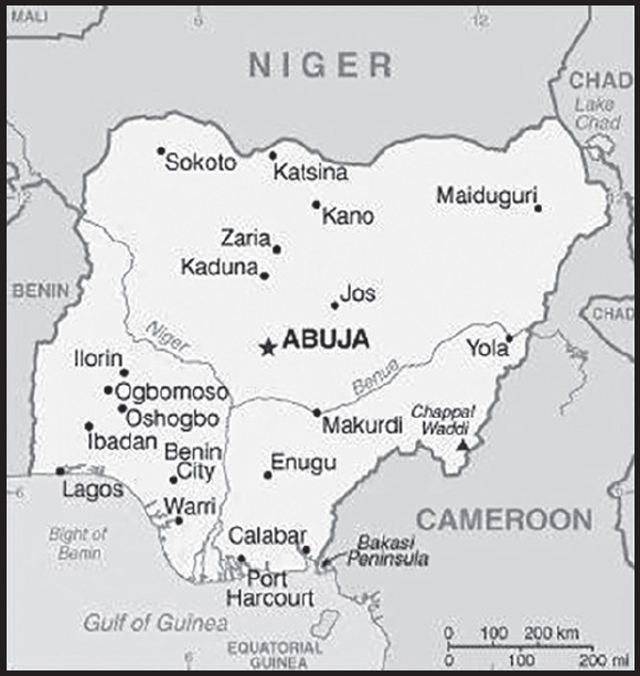
INTRODUCTION
Background: In ancient and pre-colonial times, the area of present-day Nigeria was occupied by a great diversity of ethnic groups with different languages and traditions. These included large Islamic kingdoms such as Borno, Kano, and the Sokoto Caliphate dominating the north, the Benin and Oyo Empires that controlled much of modern western Nigeria, and more decentralized political entities and city states in the south and southeast. In 1914, the British amalgamated their separately administered northern and southern territories into a Colony and Protectorate of Nigeria. Nigeria achieved independence in 1960 and transitioned to a federal republic with three constituent states in 1963 under President Nnamdi AZIKIWE. This structure served to enflame regional and ethnic tension, contributing to a bloody coup led by predominately southeastern military officers in 1966 and a countercoup later that year masterminded by northern officers. In the aftermath of this tension, the governor of Nigeria’s Eastern Region, centered on the southeast, declared the region independent as the Republic of Biafra. The ensuring civil war (1967-1970), resulted in more than a million deaths, many from starvation. While the war forged a stronger Nigerian state and national identity, it contributed to long-lasting mistrust of the southeast’s predominantly Igbo population. Wartime military leader Yakubu GOWON ruled until a bloodless coup by frustrated junior officers in 1975. This generation of officers, including Olusegun OBASANJO, Ibrahim BABANGIDA, and Muhammadu BUHARI, continue to exert significant influence in Nigeria to the present day. Military rule predominated until the first durable transition to civilian government in 1999. The general elections of 2007 marked the first civilian-to-civilian transfer of power in the country’s history. National and state elections in 2011 and 2015 were generally regarded as credible. The 2015 election was also heralded for the fact that the then-umbrella opposition party, the All Progressives Congress, defeated the long-ruling (since 1999) People’s Democratic Party, and assumed the presidency, marking the first peaceful transfer of power from one party to another. Presidential and legislative elections in 2019 and 2023 were deemed broadly free and fair despite voting irregularities, intimidation, and violence. The government continues to face the daunting task of institutionalizing democracy and reforming a petroleum-based economy, whose revenues have been squandered through decades of corruption and mismanagement. In addition, Nigeria faces increasing violence from Islamic terrorism, largely in the northeast, large scale criminal banditry focused in the northwest, secessionist violence in the southeast, and competition over land and resources nationwide.
GEOGRAPHY
Location: Western Africa, bordering the Gulf of Guinea, between Benin and Cameroon
Geographic coordinates: 10 00 N, 8 00 E
Map references: Africa
Area: total: 923,768 sq km
land: 910,768 sq km
water: 13,000 sq km
comparison ranking: total 33
Area - comparative: about six times the size of Georgia; slightly more than twice the size of California
Land boundaries: total: 4,477 km
border countries (4): Benin 809 km; Cameroon 1,975 km; Chad 85 km; Niger 1,608 km
Coastline: 853 km
Maritime claims: territorial sea: 12 nm
exclusive economic zone: 200 nm
continental shelf: 200-m depth or to the depth of exploitation
Climate: varies; equatorial in south, tropical in center, arid in north
Terrain: southern lowlands merge into central hills and plateaus; mountains in southeast, plains in north
Elevation: highest point: Chappal Waddi 2,419 m
lowest point: Atlantic Ocean 0 m
mean elevation: 380 m
Natural resources: natural gas, petroleum, tin, iron ore, coal, limestone, niobium, lead, zinc, arable land
Land use: agricultural land: 78% (2018 est.)
arable land: 37.3% (2018 est.)
permanent crops: 7.4% (2018 est.)
permanent pasture: 33.3% (2018 est.)
forest: 9.5% (2018 est.)
other: 12.5% (2018 est.)
Irrigated land: 2,930 sq km (2012)
Major lakes (area sq km): fresh water lake(s): Lake Chad (endorheic lake shared with Niger, Chad, and Cameroon) - 10,360-25,900 sq km note - area varies by season and year to year
Major rivers (by length in km): Niger river mouth (shared with Guinea [s], Mali, Benin, and Niger) - 4,200 km
note – [s] after country name indicates river source; [m] after country name indicates river mouth
Major watersheds (area sq km): Atlantic Ocean drainage: Niger (2,261,741 sq km)
Internal (endorheic basin) drainage: Lake Chad (2,497,738 sq km)
Major aquifers: Lake Chad Basin, Lullemeden-Irhazer Aquifer System
Population distribution: largest population of any African nation; significant population clusters are scattered throughout the country, with the highest density areas being in the south and southwest as shown in this population distribution map
Natural hazards: periodic droughts; flooding
Geography - note: the Niger River enters the country in the northwest and flows southward through tropical rain forests and swamps to its delta in the Gulf of Guinea
PEOPLE AND SOCIETY
Population: 230,842,743 (2023 est.)
comparison ranking: 6
Nationality: noun: Nigerian(s)
adjective: Nigerian
Ethnic groups: Hausa 30%, Yoruba 15.5%, Igbo (Ibo) 15.2%, Fulani 6%, Tiv 2.4%, Kanuri/Beriberi 2.4%, Ibibio 1.8%, Ijaw/Izon 1.8%, other 24.9% (2018 est.)
note: Nigeria, Africa’s most populous country, is composed of more than 250 ethnic groups
Languages: English (official), Hausa, Yoruba, Igbo (Ibo), Fulani, over 500 additional indigenous languages
Religions: Muslim 53.5%, Roman Catholic 10.6%, other Christian 35.3%, other 0.6% (2018 est.)
Demographic profile: Nigeria’s population is projected to grow from more than 186 million people in 2016 to 392 million in 2050, becoming the world’s fourth most populous country. Nigeria’s sustained high population growth rate will continue for the foreseeable future because of population momentum and its high birth rate. Abuja has not successfully implemented family planning programs to reduce and space births because of a lack of political will, government financing, and the availability and affordability of services and products, as well as a cultural preference for large families. Increased educational attainment, especially among women, and improvements in health care are needed to encourage and to better enable parents to opt for smaller families.
Nigeria needs to harness the potential of its burgeoning youth population in order to boost economic development, reduce widespread poverty, and channel large numbers of unemployed youth into productive activities and away from ongoing religious and ethnic violence. While most movement of Nigerians is internal, significant emigration regionally and to the West provides an outlet for Nigerians looking for economic opportunities, seeking asylum, and increasingly pursuing higher education. Immigration largely of West Africans continues to be insufficient to offset emigration and the loss of highly skilled workers. Nigeria also is a major source, transit, and destination country for forced labor and sex trafficking.
Age structure: 0-14 years: 40.69% (male 47,978,838/female 45,940,446)
15-64 years: 55.95% (male 64,923,147/female 64,241,948)
65 years and over: 3.36% (2023 est.) (male 3,635,334/female 4,123,030)
Dependency ratios: total dependency ratio: 86
youth dependency ratio: 80.6
elderly dependency ratio: 5.5
potential support ratio: 18 (2021 est.)
Median age: total: 18.6 years (2020)
male: 18.4 years
female: 18.9 years
comparison ranking: total 207
Population growth rate: 2.53% (2023 est.)
comparison ranking: 20
Birth rate: 34 births/1,000 population (2023 est.)
comparison ranking: 18
Death rate: 8.52 deaths/1,000 population (2023 est.)
comparison ranking: 72
Net migration rate: -0.21 migrant(s)/1,000 population (2023 est.)
comparison ranking: 113
Population distribution: largest population of any African nation; significant population clusters are scattered throughout the country, with the highest density areas being in the south and southwest as shown in this population distribution map
Urbanization: urban population: 54.3% of total population (2023)
rate of urbanization: 3.92% annual rate of change (2020-25 est.)
Major urban areas - population: 15.946 million Lagos, 4.348 million Kano, 3.875 million Ibadan, 3.840 million ABUJA (capital), 3.480 million Port Harcourt, 1.905 million Benin City (2023)
Sex ratio: at birth: 1.06 male(s)/female
0-14 years: 1.04 male(s)/female
15-64 years: 1.01 male(s)/female
65 years and over: 0.88 male(s)/female
total population: 1.02 male(s)/female (2023 est.)
Mother’s mean age at first birth: 20.4 years (2018 est.)
note: data represents median age at first birth among women 25-49
Maternal mortality ratio: 1,047 deaths/100,000 live births (2020 est.)
comparison ranking: 3
Infant mortality rate: total: 55.17 deaths/1,000 live births (2023 est.)
male: 60.43 deaths/1,000 live births
female: 49.6 deaths/1,000 live births
comparison ranking: total 14
Life expectancy at birth: total population: 61.79 years (2023 est.)
male: 59.93 years
female: 63.75 years
comparison ranking: total population 217
Total fertility rate: 4.57 children born/woman (2023 est.)
comparison ranking: 15
Gross reproduction rate: 2.22 (2023 est.)
Contraceptive prevalence rate: 16.6% (2018)
Drinking water source: improved: urban: 95.3% of population
rural: 68.8% of population
total: 82.6% of population
unimproved: urban: 4.7% of population
rural: 31.2% of population
total: 17.4% of population (2020 est.)
Current health expenditure: 3.4% of GDP (2020)
Physicians density: 0.38 physicians/1,000 population (2018)
Sanitation facility access: improved: urban: 81.6% of population
rural: 41.4% of population
total: 62.3% of population
unimproved: urban: 18.4% of population
rural: 58.6% of population
total: 37.7% of population (2020 est.)
Major infectious diseases: degree of risk: very high (2023)
food or waterborne diseases: bacterial and protozoal diarrhea, hepatitis A and E, and typhoid fever
vectorborne diseases: malaria, dengue fever, and yellow fever
water contact diseases: schistosomiasis
animal contact diseases: rabies
respiratory diseases: meningococcal meningitis
aerosolized dust or soil contact diseases: Lassa fever
note 1: on 4 May 2022, the Centers for Disease Control and Prevention issued a Travel Health Notice for a Yellow Fever outbreak in Nigeria; a large, ongoing outbreak of yellow fever in Nigeria began in September 2017; the outbreak is now spread throughout the country with the Nigerian Ministry of Health reporting cases of the disease in multiple states (Bauchi, Benue, Delta, Ebonyi, and Enugu); the CDC recommends travelers going to Nigeria should receive vaccination against yellow fever at least 10 days before travel and should take steps to prevent mosquito bites while there; those never vaccinated against yellow fever should avoid travel to Nigeria during the outbreak (see attached map)
note 2: on 31 August 2023, the US Centers for Disease Control and Prevention (CDC) issued a Travel Alert for polio in Africa; Nigeria is currently considered a high risk to travelers for circulating vaccine-derived polioviruses (cVDPV); vaccine-derived poliovirus (VDPV) is a strain of the weakened poliovirus that was initially included in oral polio vaccine (OPV) and that has changed over time and behaves more like the wild or naturally occurring virus; this means it can be spread more easily to people who are unvaccinated against polio and who come in contact with the stool or respiratory secretions, such as from a sneeze, of an “infected” person who received oral polio vaccine; the CDC recommends that before any international travel, anyone unvaccinated, incompletely vaccinated, or with an unknown polio vaccination status should complete the routine polio vaccine series; before travel to any high-risk destination, the CDC recommends that adults who previously completed the full, routine polio vaccine series receive a single, lifetime booster dose of polio vaccine
note 3: on 20 September 2023, the Centers for Disease Control and Prevention updated a Travel Health Alert for a diphtheria outbreak in several states in Nigeria; vaccination against diphtheria is essential to protect against disease; if you are traveling to an affected area, you should be up to date with your diphtheria vaccines; before travel, discuss the need for a booster dose with your healthcare professional; diphtheria is a serious infection caused by strains of Corynebacterium diphtheriae bacteria that make a toxin from which people get very sick; diphtheria bacteria spread from person to person through respiratory droplets like from coughing or sneezing; people can also get sick from touching open sores or ulcers of people sick with diphtheria (see attached map)
note 1: The Nigeria Centre for Disease Control (NCDC) is reporting yellow fever outbreaks in multiple states (Bauchi, Benue, Delta, Ebonyi, and Enugu). Unless vaccinated, travelers should not visit these areas. Yellow fever is caused by a virus transmitted through bites of infected mosquitoes. Travelers to Nigeria should take steps to prevent yellow fever by getting vaccinated at least 10 days before travel and taking steps to prevent mosquito bites. Map courtesy of CDC.:
note 3: There is an outbreak of diphtheria in several states in Nigeria. Vaccination against diphtheria is essential to protect against disease. If you are traveling to an affected area, you should be up to date with your diphtheria vaccines. Map courtesy of CDC.:
Obesity - adult prevalence rate: 8.9% (2016)
comparison ranking: 145
Alcohol consumption per capita: total: 4.49 liters of pure alcohol (2019 est.)
beer: 0.73 liters of pure alcohol (2019 est.)
wine: 0.09 liters of pure alcohol (2019 est.)
spirits: 0.4 liters of pure alcohol (2019 est.)
other alcohols: 3.27 liters of pure alcohol (2019 est.)
comparison ranking: total 88
Tobacco use: total: 3.7% (2020 est.)
male: 6.9% (2020 est.)
female: 0.5% (2020 est.)
comparison ranking: total 163
Children under the age of 5 years underweight: 18.4% (2019/20)
comparison ranking: 25
Currently married women (ages 15-49): 66.2% (2023 est.)
Child marriage: women married by age 15: 12.3%
women married by age 18: 30.3%
men married by age 18: 1.6% (2021 est.)
note: due to prolonged insecurity concerns, some parts of states, including Borno state, were not sampled
Education expenditures: 0.5% of GDP (2013)
comparison ranking: 196
Literacy: definition: age 15 and over can read and write
total population: 62%
male: 71.3%
female: 52.7% (2018)
Youth unemployment rate (ages 15-24): total: 19.6% (2021 est.)
male: 19.8%
female: 19.4%
comparison ranking: total 84
ENVIRONMENT
Environment - current issues: serious overpopulation and rapid urbanization have led to numerous environmental problems; urban air and water pollution; rapid deforestation; soil degradation; loss of arable land; oil pollution - water, air, and soil have suffered serious damage from oil spills
Environment - international agreements: party to: Biodiversity, Climate Change, Climate Change-Kyoto Protocol, Climate Change-Paris Agreement, Comprehensive Nuclear Test Ban, Desertification, Endangered Species, Hazardous Wastes, Law of the Sea, Marine Dumping-London Convention, Marine Dumping-London Protocol, Marine Life Conservation, Nuclear Test Ban, Ozone Layer Protection, Ship Pollution, Wetlands
signed, but not ratified: Tropical Timber 2006
Climate: varies; equatorial in south, tropical in center, arid in north
Land use: agricultural land: 78% (2018 est.)
arable land: 37.3% (2018 est.)
permanent crops: 7.4% (2018 est.)
permanent pasture: 33.3% (2018 est.)
forest: 9.5% (2018 est.)
other: 12.5% (2018 est.)
Urbanization: urban population: 54.3% of total population (2023)
rate of urbanization: 3.92% annual rate of change (2020-25 est.)
Food insecurity: widespread lack of access: due to persistent civil conflict in the northern areas, floods, high food prices, and an economic slowdown - about 25.3 million people are projected to face acute food insecurity during the June to August 2023 lean season; this would be a significant deterioration compared to last year, when 19.45 million people were estimated to be acutely food insecure; acute food insecurity is mostly driven by the deterioration of security conditions and conflicts in northern states, which have led to the displacement of about 3.17 million people as of March 2022 (the latest data available) and are constraining farmers’ access to their lands; widespread flooding in 2022, affecting about 4.5 million people across the country, has further compounded conditions, particularly in areas already facing high levels of insecurity; high food prices and the expected slowdown in economic growth in 2023 are additional drivers of acute food insecurity (2023)
Revenue from forest resources: 1.02% of GDP (2018 est.)
comparison ranking: 53
Revenue from coal: 0% of GDP (2018 est.)
comparison ranking: 86
Air pollutants: particulate matter emissions: 55.64 micrograms per cubic meter (2019 est.)
carbon dioxide emissions: 120.37 megatons (2016 est.)
methane emissions: 143.99 megatons (2020 est.)
Waste and recycling: municipal solid waste generated annually: 27,614,830 tons (2009 est.)
Major lakes (area sq km): fresh water lake(s): Lake Chad (endorheic lake shared with Niger, Chad, and Cameroon) - 10,360-25,900 sq km note - area varies by season and year to year
Major rivers (by length in km): Niger river mouth (shared with Guinea [s], Mali, Benin, and Niger) - 4,200 km
note – [s] after country name indicates river source; [m] after country name indicates river mouth
Major watersheds (area sq km): Atlantic Ocean drainage: Niger (2,261,741 sq km)
Internal (endorheic basin) drainage: Lake Chad (2,497,738 sq km)
Major aquifers: Lake Chad Basin, Lullemeden-Irhazer Aquifer System
Total water withdrawal: municipal: 5 billion cubic meters (2020 est.)
industrial: 1.97 billion cubic meters (2020 est.)
agricultural: 5.51 billion cubic meters (2020 est.)
Total renewable water resources: 286.2 billion cubic meters (2020 est.)
GOVERNMENT
Country name: conventional long form: Federal Republic of Nigeria
conventional short form: Nigeria
etymology: named for the Niger River that flows through the west of the country to the Atlantic Ocean; from a native term “Ni Gir” meaning “River Gir”
Government type: federal presidential republic
Capital: name: Abuja
geographic coordinates: 9 05 N, 7 32 E
time difference: UTC+1 (6 hours ahead of Washington, DC, during Standard Time)
etymology: Abuja is a planned capital city, it replaced Lagos in 1991; situated in the center of the country, Abuja takes its name from a nearby town, now renamed Suleja
Administrative divisions: 36 states and 1 territory*; Abia, Adamawa, Akwa Ibom, Anambra, Bauchi, Bayelsa, Benue, Borno, Cross River, Delta, Ebonyi, Edo, Ekiti, Enugu, Federal Capital Territory*, Gombe, Imo, Jigawa, Kaduna, Kano, Katsina, Kebbi, Kogi, Kwara, Lagos, Nasarawa, Niger, Ogun, Ondo, Osun, Oyo, Plateau, Rivers, Sokoto, Taraba, Yobe, Zamfara
Independence: 1 October 1960 (from the UK)
National holiday: Independence Day (National Day), 1 October (1960)
Constitution: history: several previous; latest adopted 5 May 1999, effective 29 May 1999
amendments: proposed by the National Assembly; passage requires at least two-thirds majority vote of both houses and approval by the Houses of Assembly of at least two thirds of the states; amendments to constitutional articles on the creation of a new state, fundamental constitutional rights, or constitution-amending procedures requires at least four-fifths majority vote by both houses of the National Assembly and approval by the Houses of Assembly in at least two thirds of the states; passage of amendments limited to the creation of a new state require at least two-thirds majority vote by the proposing National Assembly house and approval by the Houses of Assembly in two thirds of the states; amended several times, last in 2018
Legal system: mixed legal system of English common law, Islamic law (in 12 northern states), and traditional law
International law organization participation: accepts compulsory ICJ jurisdiction with reservations; accepts ICCt jurisdiction
Citizenship: citizenship by birth: no
citizenship by descent only: at least one parent must be a citizen of Nigeria
dual citizenship recognized: yes
residency requirement for naturalization: 15 years
Suffrage: 18 years of age; universal
Executive branch: chief of state: President Bola Ahmed Adekunle TINUBU (since 29 May 2023); Vice President Kashim SHETTIMA (since 29 May 2023); note - the president is both chief of state, head of government, and commander-in-chief of the armed forces
head of government: President Bola Ahmed Adekunle TINUBU (since 29 May 2023); Vice President Kashim SHETTIMA (since 29 May 2023)
cabinet: Federal Executive Council appointed by the president but constrained constitutionally to include at least one member from each of the 36 states
elections/appointments: president directly elected by qualified majority popular vote and at least 25% of the votes cast in 24 of Nigeria’s 36 states; president elected for a 4-year term (eligible for a second term); election last held on 25 February 2023 (next to be held on 27 February 2027)
election results:
2023: Bola Ahmed Adekunle TINUBU elected president; percent of vote - Bola Ahmed Adekunle TINUBU (APC) 36.6%, Atiku ABUBAKAR (PDP) 29.1%, Peter OBI (LP) 25.4%, Rabiu KWANKWASO (NNPP) 6.4%, other 2.5%
2019: Muhammadu BUHARI elected president; percent of vote - Muhammadu BUHARI (APC) 53%, Atiku ABUBAKAR (PDP) 39%, other 8%
Legislative branch: description: bicameral National Assembly consists of:
Senate (109 seats - 3 each for the 36 states and 1 for Abuja-Federal Capital Territory; members directly elected in single-seat constituencies by simple majority vote to serve 4-year terms)
House of Representatives (360 seats statutory, 258 current; members directly elected in single-seat constituencies by simple majority vote to serve 4-year terms)
elections:
Senate - last held on 25 February 2023 (next to be held on 25 February 2027)
House of Representatives - last held on 25 February 2023 (next to be held on 25 February 2027)
election results:
Senate - percent of vote by party - NA; seats by party - APC 59, PDP 36, LP 8, NNPP 2, SDP 2, YPP 1, APGA 1; composition - men 106, women 3, percent of women 2.75%
House of Representatives - percent of vote by party - NA; seats by party - APC 178, PDP 114, LP 35, NNPP 19, APGA 5, other 7, vacant 2; composition - men 344, women 14, percent of women 3.8%; note - total National Assembly percent of women 3.6%
Judicial branch: highest court(s): Supreme Court (consists of the chief justice and 15 justices)
judge selection and term of office: judges appointed by the president upon the recommendation of the National Judicial Council, a 23-member independent body of federal and state judicial officials; judge appointments confirmed by the Senate; judges serve until age 70
subordinate courts: Court of Appeal; Federal High Court; High Court of the Federal Capital Territory; Sharia Court of Appeal of the Federal Capital Territory; Customary Court of Appeal of the Federal Capital Territory; state court system similar in structure to federal system
Political parties and leaders: Accord Party or ACC [Mohammad Lawal MALADO]
Africa Democratic Congress or ADC [Ralph Okey NWOSU]
All Progressives Congress or APC [Abdullahi ADAMU]
All Progressives Grand Alliance or APGA [Victor Ike OYE]
Labor Party or LP [Julius ABURE]
Peoples Democratic Party or PDP [Iyourchia AYU]
Young Progressive Party or YPP [Bishop AMAKIRI]
International organization participation: ACP, AfDB, ATMIS, AU, C, CD, D-8, ECOWAS, EITI (compliant country), FAO, G-15, G-24, G-77, IAEA, IBRD, ICAO, ICC (national committees), ICCt, ICRM, IDA, IDB, IFAD, IFC, IFRCS, IHO, ILO, IMF, IMO, IMSO, Interpol, IOC, IOM, IPU, ISO, ITSO, ITU, ITUC (NGOs), LCBC, MIGA, MINURSO, MINUSMA, MNJTF, MONUSCO, NAM, OAS (observer), OIC, OPCW, OPEC, PCA, UN, UNAMID, UNCTAD, UNESCO, UNHCR, UNIDO, UNIFIL, UNISFA, UNITAR, UNMIL, UNMISS, UNOCI, UNWTO, UPU, WCO, WFTU (NGOs), WHO, WIPO, WMO, WTO
Diplomatic representation in the US: chief of mission: Ambassador Uzoma Elizabeth EMENIKE (since 7 July 2021)
chancery: 3519 International Court NW, Washington, DC 20008
telephone: [1] (202) 800-7201 (ext. 100)
FAX: [1] (202) 362-6541
email address and website:
https://www.nigeriaembassyusa.org/
consulate(s) general: Atlanta, New York
Diplomatic representation from the US: chief of mission: Ambassador (vacant); Charge d’Affaires David GREENE (since 31 March 2023)
embassy: Plot 1075 Diplomatic Drive, Central District Area, Abuja
mailing address: 8320 Abuja Place, Washington DC 20521-8320
telephone: [234] (9) 461-4000
FAX: [234] (9) 461-4036
email address and website:
consulate(s) general: Lagos
Flag description: three equal vertical bands of green (hoist side), white, and green; the color green represents the forests and abundant natural wealth of the country, white stands for peace and unity
National symbol(s): eagle; national colors: green, white
National anthem: name: “Arise Oh Compatriots, Nigeria’s Call Obey”
lyrics/music: John A. ILECHUKWU, Eme Etim AKPAN, B.A. OGUNNAIKE, Sotu OMOIGUI and P.O. ADERIBIGBE/Benedict Elide ODIASE
note: adopted 1978; lyrics are a mixture of the five top entries in a national contest
National heritage: total World Heritage Sites: 2 (both cultural)
selected World Heritage Site locales: Sukur Cultural Landscape; Osun-Osogbo Sacred Grove
ECONOMY
Economic overview: largest African market economy; enormous but mostly lower middle income labor force; major oil exporter; key telecommunications and finance industries; susceptible to energy prices; regional leader in critical infrastructure; primarily agrarian employment
Real GDP (purchasing power parity): $1.05 trillion (2021 est.)
$1.014 trillion (2020 est.)
$1.032 trillion (2019 est.)
note: data are in 2017 dollars
comparison ranking: 25
Real GDP growth rate: 3.65% (2021 est.)
-1.79% (2020 est.)
2.21% (2019 est.)
comparison ranking: 131
Real GDP per capita: $4,900 (2021 est.)
$4,900 (2020 est.)
$5,100 (2019 est.)
note: data are in 2017 dollars
comparison ranking: 179
GDP (official exchange rate): $475.062 billion (2019 est.)
Inflation rate (consumer prices): 16.95% (2021 est.)
13.25% (2020 est.)
11.4% (2019 est.)
comparison ranking: 17
Credit ratings: Fitch rating: B (2020)
Moody’s rating: B2 (2017)
Standard & Poors rating: B- (2020)
note: The year refers to the year in which the current credit rating was first obtained.
GDP - composition, by sector of origin: agriculture: 21.1% (2016 est.)
industry: 22.5% (2016 est.)
services: 56.4% (2017 est.)
comparison rankings: services 149; industry 127; agriculture 43
GDP - composition, by end use: household consumption: 80% (2017 est.)
government consumption: 5.8% (2017 est.)
investment in fixed capital: 14.8% (2017 est.)
investment in inventories: 0.7% (2017 est.)
exports of goods and services: 11.9% (2017 est.)
imports of goods and services: -13.2% (2017 est.)
Agricultural products: cassava, yams, maize, oil palm fruit, rice, vegetables, sorghum, groundnuts, fruit, sweet potatoes
Industries: crude oil, coal, tin, columbite; rubber products, wood; hides and skins, textiles, cement and other construction materials, food products, footwear, chemicals, fertilizer, printing, ceramics, steel
Industrial production growth rate: -0.47% (2021 est.)
comparison ranking: 161
Labor force: 65.116 million (2021 est.)
comparison ranking: 10
Labor force - by occupation: agriculture: 70%
industry: 10%
services: 20% (1999 est.)
Unemployment rate: 9.79% (2021 est.)
9.71% (2020 est.)
8.53% (2019 est.)
comparison ranking: 74
Youth unemployment rate (ages 15-24): total: 19.6% (2021 est.)
male: 19.8%
female: 19.4%
comparison ranking: total 84
Population below poverty line: 40.1% (2018 est.)
Gini Index coefficient - distribution of family income: 35.1 (2018 est.)
comparison ranking: 98
Average household expenditures: on food: 59% of household expenditures (2018 est.)
on alcohol and tobacco: 1% of household expenditures (2018 est.)
Household income or consumption by percentage share: lowest 10%: 1.8%
highest 10%: 38.2% (2010 est.)
Budget: revenues: $37.298 billion (2019 est.)
expenditures: $59.868 billion (2019 est.)
Budget surplus (+) or deficit (-): -1.8% (of GDP) (2017 est.)
comparison ranking: 96
Public debt: 21.8% of GDP (2017 est.)
19.6% of GDP (2016 est.)
comparison ranking: 186
Taxes and other revenues: 3.4% (of GDP) (2017 est.)
comparison ranking: 219
Fiscal year: calendar year
Current account balance: -$1.849 billion (2021 est.)
-$15.986 billion (2020 est.)
-$13.685 billion (2019 est.)
comparison ranking: 153
Exports: $50.856 billion (2021 est.) note: data are in current year dollars
$39.937 billion (2020 est.) note: data are in current year dollars
$69.927 billion (2019 est.) note: data are in current year dollars
comparison ranking: 62
Exports - partners: India 16%, Spain 12%, United States 6%, France 6%, China 5% (2021)
Exports - commodities: crude petroleum, natural gas, scrap vessels, cocoa beans, refined petroleum (2021)
Imports: $66.107 billion (2021 est.) note: data are in current year dollars
$72.178 billion (2020 est.) note: data are in current year dollars
$100.82 billion (2019 est.) note: data are in current year dollars
comparison ranking: 55
Imports - partners: China 30%, Netherlands 11%, United States 6%, Belgium 5% (2019)
Imports - commodities: refined petroleum, cars, wheat, laboratory glassware, packaged medicines (2019)
Reserves of foreign exchange and gold: $36.73 billion (31 December 2020 est.)
$38.336 billion (31 December 2019 est.)
$42.839 billion (31 December 2018 est.)
comparison ranking: 53
Debt - external: $26.847 billion (2019 est.)
$22.755 billion (2018 est.)
comparison ranking: 88
Exchange rates: nairas (NGN) per US dollar -
Exchange rates: 358.811 (2020 est.)
306.921 (2019 est.)
306.084 (2018 est.)
305.79 (2017 est.)
253.492 (2016 est.)
ENERGY
Electricity access: population without electricity: 66 million (2020)
electrification - total population: 59.6% (2021)
electrification - urban areas: 89.2% (2021)
electrification - rural areas: 26.3% (2021)
Electricity: installed generating capacity: 11.691 million kW (2020 est.)
consumption: 24,611,480,000 kWh (2019 est.)
exports: 0 kWh (2019 est.)
imports: 0 kWh (2019 est.)
transmission/distribution losses: 4.713 billion kWh (2019 est.)
comparison rankings: installed generating capacity 58; transmission/distribution losses 47; imports 173; exports 164; consumption 70
Electricity generation sources: fossil fuels: 78.1% of total installed capacity (2020 est.)
solar: 0.2% of total installed capacity (2020 est.)
hydroelectricity: 21.7% of total installed capacity (2020 est.)
biomass and waste: 0.1% of total installed capacity (2020 est.)
Coal: production: 44,000 metric tons (2020 est.)
consumption: 85,000 metric tons (2020 est.)
exports: 12,000 metric tons (2020 est.)
imports: 77,000 metric tons (2020 est.)
proven reserves: 344 million metric tons (2019 est.)
Petroleum: total petroleum production: 1,646,900 bbl/day (2021 est.)
refined petroleum consumption: 483,100 bbl/day (2019 est.)
crude oil and lease condensate exports: 1,889,100 bbl/day (2018 est.)
crude oil and lease condensate imports: 0 bbl/day (2018 est.)
crude oil estimated reserves: 36.89 billion barrels (2021 est.)
Refined petroleum products - production: 35,010 bbl/day (2017 est.)
comparison ranking: 83
Refined petroleum products - exports: 2,332 bbl/day (2015 est.)
comparison ranking: 102
Refined petroleum products - imports: 223,400 bbl/day (2015 est.)
comparison ranking: 31
Natural gas: production: 46,296,835,000 cubic meters (2019 est.)
consumption: 18,787,602,000 cubic meters (2019 est.)
exports: 27,509,177,000 cubic meters (2019 est.)
imports: 0 cubic meters (2021 est.)
proven reserves: 5,760,883,000,000 cubic meters (2021 est.)
Carbon dioxide emissions: 104.494 million metric tonnes of CO2 (2019 est.)
from coal and metallurgical coke: 231,000 metric tonnes of CO2 (2019 est.)
from petroleum and other liquids: 67.406 million metric tonnes of CO2 (2019 est.)
from consumed natural gas: 36.856 million metric tonnes of CO2 (2019 est.)
comparison ranking: total emissions 40
Energy consumption per capita: 8.466 million Btu/person (2019 est.)
comparison ranking: 160
COMMUNICATIONS
Telephones - fixed lines: total subscriptions: 106,385 (2021 est.)
subscriptions per 100 inhabitants: (2021 est.) less than 1
comparison ranking: total subscriptions 137
Telephones - mobile cellular: total subscriptions: 195,128,265 (2021 est.)
subscriptions per 100 inhabitants: 91 (2021 est.)
comparison ranking: total subscriptions 8
Telecommunication systems: general assessment: one of the larger telecom markets in Africa subject to sporadic access to electricity and vandalism of infrastructure; most Internet connections are via mobile networks; market competition with affordable access; LTE technologies available but GSM is dominant; mobile penetration high due to use of multiple SIM cards and phones; government committed to expanding broadband penetration; operators to deploy fiber optic cable in six geopolitical zones and Lagos; operators invested in base stations to deplete network congestion; submarine cable break in 2020 slowed speeds and interrupted connectivity; Nigeria concluded its first 5G spectrum auction in 2021 and granted licenses to two firms; construction of 5G infrastructure has not yet been completed (2022)
domestic: fixed-line subscribership remains less than 1 per 100 persons; mobile-cellular subscribership is 91 per 100 persons (2021)
international: country code - 234; landing point for the SAT-3/WASC, NCSCS, MainOne, Glo-1 & 2, ACE, and Equiano fiber-optic submarine cable that provides connectivity to Europe and South and West Africa; satellite earth stations - 3 Intelsat (2 Atlantic Ocean and 1 Indian Ocean) (2019)
Broadcast media: nearly 70 federal government-controlled national and regional TV stations; all 36 states operate TV stations; several private TV stations operational; cable and satellite TV subscription services are available; network of federal government-controlled national, regional, and state radio stations; roughly 40 state government-owned radio stations typically carry their own programs except for news broadcasts; about 20 private radio stations; transmissions of international broadcasters are available; digital broadcasting migration process completed in three states in 2018 (2019)
Internet country code: .ng
Internet users: total: 115.5 million (2021 est.)
percent of population: 55% (2021 est.)
comparison ranking: total 7
Broadband - fixed subscriptions: total: 65,313 (2020 est.)
subscriptions per 100 inhabitants: 0.03 (2020 est.)
comparison ranking: total 137
TRANSPORTATION
National air transport system: number of registered air carriers: 13 (2020)
inventory of registered aircraft operated by air carriers: 104
annual passenger traffic on registered air carriers: 8,169,192 (2018)
annual freight traffic on registered air carriers: 19.42 million (2018) mt-km
Civil aircraft registration country code prefix: 5N
Airports: 54 (2021)
comparison ranking: total 86
Airports - with paved runways: 40
civil airports: 8
military airports: 0
joint use (civil-military) airports: 3
other airports: 29
note: paved runways have a concrete or asphalt surface but not all have facilities for refueling, maintenance, or air traffic control; the length of a runway required for aircraft to safely operate depends on a number of factors including the type of aircraft, the takeoff weight (including passengers, cargo, and fuel), engine types, flap settings, landing speed, elevation of the airport, and average maximum daily air temperature; paved runways can reach a length of 5,000 m (16,000 ft.), but the “typical” length of a commercial airline runway is between 2,500-4,000 m (8,000-13,000 ft.)
Airports - with unpaved runways: 14
note: unpaved runways have a surface composition such as grass or packed earth and are most suited to the operation of light aircraft; unpaved runways are usually short, often less than 1,000 m (3,280 ft.) in length; airports with unpaved runways often lack facilities for refueling, maintenance, or air traffic control
Heliports: 5 (2021)
Pipelines: 124 km condensate, 4,045 km gas, 164 km liquid petroleum gas, 4,441 km oil, 3,940 km refined products (2013)
Railways: total: 3,798 km (2014)
standard gauge: 293 km (2014) 1.435-m gauge
narrow gauge: 3,505 km (2014) 1.067-m gauge
note: as of the end of 2018, there were only six operational locomotives in Nigeria primarily used for passenger service; the majority of the rail lines are in a severe state of disrepair and need to be replaced
comparison ranking: total 52
Roadways: total: 195,000 km (2017)
paved: 60,000 km (2017)
unpaved: 135,000 km (2017)
comparison ranking: total 29
Waterways: 8,600 km (2011) (Niger and Benue Rivers and smaller rivers and creeks)
comparison ranking: 17
Merchant marine: total: 832 (2022)
by type: general cargo 16, oil tanker 111, other 705
comparison ranking: total 27
Ports and terminals: major seaport(s): Bonny Inshore Terminal, Calabar, Lagos
oil terminal(s): Bonny Terminal, Brass Terminal, Escravos Terminal, Forcados Terminal, Pennington Terminal, Qua Iboe Terminal
LNG terminal(s) (export): Bonny Island
MILITARY AND SECURITY
Military and security forces: Armed Forces of Nigeria (AFN): Army, Navy (includes Coast Guard), Air Force
Ministry of Interior: Nigeria Security and Civil Defense Corps (NSCDC), Nigeria Police Force (NPF) (2023)
note 1: the NSCDC is a paramilitary agency commissioned to assist the military in the management of threats to internal security, including attacks and natural disasters
note 2: the Office of the National Security Advisor is responsible for coordinating all security and enforcement agencies, including the Department of State Security (DSS), the NSCDC, the Ministry of Justice, and the NPF; border security responsibilities are shared among the NPF, the DSS, the NSCDC, Customs, Immigration, and the Nigerian military
note 3: some states have created local security forces in response to increased violence, insecurity, and criminality that have exceeded the response capacity of government security forces
Military expenditures: 0.6% of GDP (2022 est.)
0.7% of GDP (2021 est.)
0.6% of GDP (2020 est.)
0.5% of GDP (2019 est.)
0.5% of GDP (2018 est.)
comparison ranking: 158
Military and security service personnel strengths: information varies; approximately 135,000 active-duty armed forces personnel (100,000 Army; 20,000 Navy/Coast Guard; 15,000 Air Force); approximately 80,000 Security and Civil Defense Corps (2023)
Military equipment inventories and acquisitions: the military’s inventory consists of a wide variety of imported weapons systems of Chinese, European, Middle Eastern, Russian (including Soviet-era), and US origin; the military is undergoing a considerable modernization program, and in recent years has received equipment from nearly 20 countries with China and Russia as the leading suppliers; Nigeria is also developing a defense-industry capacity, including small arms, armored personnel vehicles, and small-scale naval production (2023)
Military service age and obligation: 18-26 years of age for voluntary military service for men and women; no conscription (2023)
Military deployments: 175 Sudan/South Sudan (UNISFA); has about 200 police and military assigned to the MINUSMA mission in Mali (2023)
note: Nigeria has committed an Army combat brigade (approximately 3,000 troops) to the Multinational Joint Task Force (MNJTF), a regional counter-terrorism force comprised of troops from Benin, Cameroon, Chad, and Niger; MNJTF conducts operations against Boko Haram and other terrorist groups operating in the general area of the Lake Chad Basin and along Nigeria’s northeast border; national MNJTF troop contingents are deployed within their own country territories, although cross-border operations are conducted periodically
Military - note: the Nigerian military is sub-Saharan Africa’s largest and regarded as one of its most capable forces; the Army is organized into 8 divisions comprised of a diverse mix of more than 20 combat brigades, including airborne infantry, amphibious infantry, armor, artillery, light infantry, mechanized and motorized infantry, and special operations forces; there is also a presidential guard brigade; the Army typically organizes into battalion- and brigade-sized task forces for operations; the Air Force has a few squadrons of fighters, ground attack fighters, armed UAVs, and attack helicopter squadrons primarily for supporting the Army
the Army and Air Force are focused largely on internal security and face a number of challenges that have stretched their resources; the Army is deployed in all 36 of the country’s states; in the northeast, it is conducting counterinsurgency/counterterrorist operations against the Boko Haram (BH) and Islamic State of Iraq and ash-Sham in West Africa (ISIS-WA) terrorist groups, where it has deployed as many as 70,000 troops at times and jihadist-related violence has killed an estimated 35-40,000 people, mostly civilians, since 2009; in the northwest, it faces growing threats from criminal gangs--locally referred to as bandits--and violence associated with long-standing farmer-herder conflicts, as well as BH and ISIS-WA terrorists; bandits in the northwestern Nigeria are estimated to number in the low 10,000s and violence there has killed more than 10,000 people since the mid-2010s; the military also continues to protect the oil industry in the Niger Delta region against militants and criminal activity, although the levels of violence there have decreased in recent years; since 2021, additional troops and security forces have been deployed to eastern Nigeria to quell renewed agitation for a state of Biafra (Biafra seceded from Nigeria in the late 1960s, sparking a civil war that caused more than 1 million deaths)
meanwhile, the Navy is focused on security in the Gulf of Guinea; since 2016, it has developed a maritime strategy, boosted naval training and its naval presence in the Gulf, increased participation in regional maritime security efforts, and acquired a considerable number of new naval platforms, including offshore and coastal patrol craft, fast attack boats, and air assets; its principal surface ships currently include a frigate and 4 corvettes or offshore patrol ships
the Nigerian military traces its origins to the Nigeria Regiment of the West African Frontier Force (WAFF), a multiregiment force formed by the British colonial office in 1900 to garrison the West African colonies of Nigeria (Lagos and the protectorates of Northern and Southern Nigeria), Gold Coast, Sierra Leone, and Gambia; the WAFF served with distinction in both East and West Africa during World War I; in 1928, it received royal recognition and was re-named the Royal West African Frontier Force (RWAFF); the RWAFF went on to serve in World War II as part of the British 81st and 82nd (West African) divisions in the East Africa and Burma campaigns; in 1956, the Nigeria Regiment of the RWAFF was renamed the Nigerian Military Forces (NMF) and in 1958, the colonial government of Nigeria took over control of the NMF from the British War Office; the Nigerian Armed Forces were established following independence in 1960 (2023)
SPACE
Space agency/agencies: National Space Research and Development Agency (NARSDA; established 1999); NARSDA originated from the National Centre for Remote Sensing and National Committee on Space Applications (both established in 1987), and the Directorate of Science (established 1993); Defense Space Administration (DSA; established 2014) (2023)
Space program overview: has a formal national space program, which is one of the largest in Africa; focused on acquiring satellites for agricultural, environmental, meteorology, mining and disaster monitoring, socio-economic development, and security purposes; designs, builds (mostly with foreign assistance), and operates satellites; processes overhead imagery data for analysis and sharing; developing additional capabilities in satellite and satellite payload production, including remote sensing (RS) technologies; researching rockets and rocket propulsion systems with goal of launching domestically produced satellites into space from a Nigerian spaceport by 2030; has relations and/or cooperation agreements with a variety of foreign space agencies and industries, including those of Algeria, Bangladesh, Belarus, China, Ghana, Japan, Kenya, Mongolia, South Africa, Thailand, Turkey, the UK, the US, and Vietnam; has a government-owned satellite company and a small commercial aerospace sector (2023)
note: further details about the key activities, programs, and milestones of the country’s space program, as well as government spending estimates on the space sector, appear in Appendix S
TERRORISM
Terrorist group(s): Terrorist group(s): Boko Haram; Islamic State of Iraq and ash-Sham – West Africa; Jama’atu Ansarul Muslimina Fi Biladis-Sudan (Ansaru)
note: details about the history, aims, leadership, organization, areas of operation, tactics, targets, weapons, size, and sources of support of the group(s) appear(s) in Appendix-T
TRANSNATIONAL ISSUES
Disputes - international: Nigeria-Benin: none identified
Nigeria-Cameroon: Joint Border Commission with Cameroon reviewed 2002 ICJ ruling on the entire boundary and bilaterally resolved differences, including June 2006 Greentree Agreement that immediately ceded sovereignty of the Bakassi Peninsula to Cameroon with a phaseout of Nigerian control within two years while resolving patriation issues; demarcation of the Bakassi Peninsula and adjoining border areas should be finalized in 2022; as Lake Chad’s evaporation exposed dry land, only Nigeria and Cameroon have heeded the Lake Chad Commission’s admonition to ratify the delimitation treaty which also includes the Chad-Niger and Niger-Nigeria boundaries
Nigeria-Cameroon-Equatorial Guinea: the ICJ ruled on an equidistance settlement of Cameroon-Equatorial Guinea-Nigeria maritime boundary in the Gulf of Guinea, but imprecisely defined coordinates in the ICJ decision and a sovereignty dispute between Equatorial Guinea and Cameroon over an island at the mouth of the Ntem River all contribute to the delay in implementation
Nigeria-Niger: none identified
Refugees and internally displaced persons: refugees (country of origin): 89,045 (Cameroon) (2023)
IDPs: 3.15 million (northeast Nigeria; Boko Haram attacks and counterinsurgency efforts in northern Nigeria; communal violence between Christians and Muslims in the middle belt region, political violence; flooding; forced evictions; cattle rustling; competition for resources) (2023)
Illicit drugs: Nigeria is a major hub for transnational drug trafficking networks entrenched throughout the world and supplying cocaine to Asia and Europe, heroin to Europe and North America, and methamphetamine to South Africa, Southeast Asia, Australia, and New Zealand; also exporting massive quantities of opioids such as tramadol and captagon along with crack cocaine; a major source of precursor or essential chemicals used in the production of illicit narcotics