NIUE
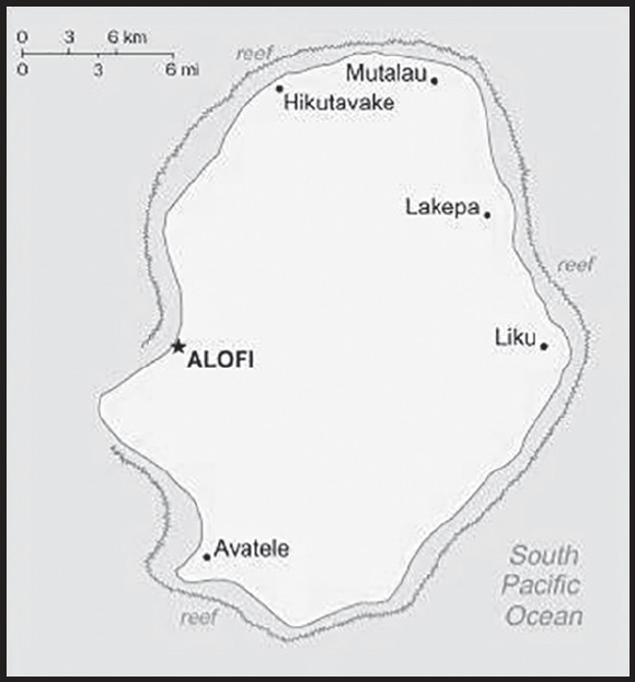
INTRODUCTION
Background: Voyagers from Samoa first settled on Niue around A.D. 900 and a second main group of settlers came from Tonga around 1500. With only one reliable source of fresh water, conflict was high on the island. There was continued contact with both Samoa and Tonga, and customs from those islands heavily influenced Niuean culture, including the formation of an island-wide kingship system in the early 1700s. These kings, or patu-iki, were elected by Niueans. In 1774, British explorer James COOK abandoned attempts to land on the island after several unsuccessful tries, and he named it Savage Island because of the warlike appearance of the Niueans. Missionaries arrived in 1830 but were also largely unsuccessful at staying on the island until 1846, when a Niuean trained as a Samoan missionary returned to the island and provided a space from which the missionaries could work. In addition to converting the population, the missionaries worked to stop the violent conflicts between Niueans and helped establish the first parliament in 1849.
In 1889, King FATAAIKI and other chiefs asked the UK for protectorate status, a request that was repeated in 1895. The UK finally agreed in 1900 and King TOGIA-PULU-TOAKI formally ceded Niue that year. In 1901, Niue was annexed to New Zealand and included as part of the Cook Islands. Niue’s remoteness and cultural and linguistic differences with the Cook Islands led New Zealand to separate Niue into its own administration in 1904. The island became internally self-governing in 1974; it is an independent member of international organizations but is in free association with New Zealand, which is responsible for defense and foreign affairs. In September 2023, the US recognized Niue as a sovereign and independent state.
GEOGRAPHY
Location: Oceania, island in the South Pacific Ocean, east of Tonga
Geographic coordinates: 19 02 S, 169 52 W
Map references: Oceania
Area: total: 260 sq km
land: 260 sq km
water: 0 sq km
comparison ranking: total 212
Area - comparative: 1.5 times the size of Washington, DC
Land boundaries: total: 0 km
Coastline: 64 km
Maritime claims: territorial sea: 12 nm
exclusive economic zone: 200 nm
Climate: tropical; modified by southeast trade winds
Terrain: steep limestone cliffs along coast, central plateau
Elevation: highest point: unnamed elevation 1.4 km east of Hikutavake 80 m
lowest point: Pacific Ocean 0 m
Natural resources: arable land, fish
Land use: agricultural land: 19.1% (2018 est.)
arable land: 3.8% (2018 est.)
permanent crops: 11.5% (2018 est.)
permanent pasture: 3.8% (2018 est.)
forest: 71.2% (2018 est.)
other: 9.7% (2018 est.)
Irrigated land: 0 sq km (2022)
Population distribution: population distributed around the peripheral coastal areas of the island
Natural hazards: tropical cyclones
Geography - note: one of world’s largest coral islands; the only major break in the surrounding coral reef occurs in the central western part of the coast
PEOPLE AND SOCIETY
Population: 2,000 (July 2022 est.)
note: because of the island’s limited economic and educational opportunities, Niueans have emigrated for decades - primarily to New Zealand, but also to Australia and other Pacific island states; Niue’s population peaked in 1966 at 5,194, but by 2005 had fallen to 1,508; since then it has rebounded slightly; as of 2013, 23,883 people of Niuean ancestry lived in New Zealand - with more than 20% Niue-born; this means that there are about 15 times as many persons of Niuean ancestry living in New Zealand as in Niue, possibly the most eccentric population distribution in the world
comparison ranking: 231
Nationality: noun: Niuean(s)
adjective: Niuean
Ethnic groups: Niuean 65.4%, part-Niuean 14%, non-Niuean 20.6% (2017 est.)
note: data represent the resident population
Languages: Niuean (official) 46% (a Polynesian language closely related to Tongan and Samoan), Niuean and English 32%, English (official) 11%, Niuean and others 5%, other 6% (2011 est.)
Religions: Ekalesia Niue (Congregational Christian Church of Niue - a Protestant church founded by missionaries from the London Missionary Society) 61.7%, Church of Jesus Christ 8.7%, Roman Catholic 8.4%, Jehovah’s Witness 2.7%, Seventh Day Adventist 1.4%, other 8.2%, none 8.9% (2017 est.)
Dependency ratios: total dependency ratio: 70.4
youth dependency ratio: 44.9
elderly dependency ratio: 25.4
potential support ratio: 3.9 (2021)
Population growth rate: -0.03% (2021 est.)
comparison ranking: 198
Population distribution: population distributed around the peripheral coastal areas of the island
Urbanization: urban population: 48.2% of total population (2023)
rate of urbanization: 1.43% annual rate of change (2020-25 est.)
Major urban areas - population: 1,000 ALOFI (capital) (2018)
Drinking water source: improved: total: 97% of population
unimproved: total: 3% of population (2020 est.)
Current health expenditure: 7.8% of GDP (2020)
Sanitation facility access: improved: total: 95.5% of population
unimproved: total: 4.5% of population (2020 est.)
Obesity - adult prevalence rate: 50% (2016)
comparison ranking: 6
Alcohol consumption per capita: total: 8.5 liters of pure alcohol (2019 est.)
beer: 4.28 liters of pure alcohol (2019 est.)
wine: 1.89 liters of pure alcohol (2019 est.)
spirits: 2.33 liters of pure alcohol (2019 est.)
other alcohols: 0 liters of pure alcohol (2019 est.)
comparison ranking: total 38
Children under the age of 5 years underweight: ENVIRONMENT
Environment - current issues: increasing attention to conservationist practices to counter loss of soil fertility from traditional slash and burn agriculture
Environment - international agreements: party to: Biodiversity, Climate Change, Climate Change-Kyoto Protocol, Climate Change-Paris Agreement, Comprehensive Nuclear Test Ban, Desertification, Law of the Sea, Ozone Layer Protection, Ship Pollution
signed, but not ratified: none of the selected agreements
Climate: tropical; modified by southeast trade winds
Land use: agricultural land: 19.1% (2018 est.)
arable land: 3.8% (2018 est.)
permanent crops: 11.5% (2018 est.)
permanent pasture: 3.8% (2018 est.)
forest: 71.2% (2018 est.)
other: 9.7% (2018 est.)
Urbanization: urban population: 48.2% of total population (2023)
rate of urbanization: 1.43% annual rate of change (2020-25 est.)
Air pollutants: particulate matter emissions: 6.74 micrograms per cubic meter (2019 est.)
Total renewable water resources: 0 cubic meters (2017 est.)
GOVERNMENT
Country name: conventional long form: none
conventional short form: Niue
former: Savage Island
etymology: the origin of the name is obscure; in Niuean, the word supposedly translates as “behold the coconut”
note: pronunciation falls between nyu-way and new-way, but not like new-wee
Government type: parliamentary democracy
Dependency status: self-governing in free association with New Zealand since 1974; Niue is fully responsible for internal affairs; New Zealand retains responsibility for external affairs and defense; however, these responsibilities confer no rights of control and are only exercised at the request of the Government of Niue
Capital: name: Alofi
geographic coordinates: 19 01 S, 169 55 W
time difference: UTC-11 (6 hours behind Washington, DC, during Standard Time)
Administrative divisions: none; there are no first-order administrative divisions as defined by the US Government, but there are 14 villages at the second order
Independence: 19 October 1974 (Niue became a self-governing state in free association with New Zealand)
National holiday: Waitangi Day (Treaty of Waitangi established British sovereignty over New Zealand), 6 February (1840)
Constitution: history: several previous (New Zealand colonial statutes); latest 19 October 1974 (Niue Constitution Act 1974)
amendments: proposed by the Assembly; passage requires at least two-thirds majority vote of the Assembly membership in each of three readings and approval by at least two-thirds majority votes in a referendum; passage of amendments to a number of sections, including Niue’s self-governing status, British nationality and New Zealand citizenship, external affairs and defense, economic and administrative assistance by New Zealand, and amendment procedures, requires at least two-thirds majority vote by the Assembly and at least two thirds of votes in a referendum; amended 1992, 2007; note - in early 2021, the constitution review committee of the Assembly requested suggestions from the public about changes to the constitution
Legal system: English common law
Suffrage: 18 years of age; universal
Executive branch: chief of state: King CHARLES III (since 8 September 2022); represented by Governor-General of New Zealand Cindy KIRO (since 21 October 2021); the UK and New Zealand are represented by New Zealand High Commissioner Helen TUNNAH (since July 2020)
head of government: Premier Dalton TAGELAGI (since 10 June 2020)
cabinet: Cabinet chosen by the premier
elections/appointments: the monarchy is hereditary; premier indirectly elected by the Legislative Assembly for a 3-year term; election last held on 8 May 2023 (next to be held in 2026)
election results: Dalton TAGELAGI reelected premier; Legislative Assembly vote - Dalton TAGELAGI (independent) 16, O’Love JACOBSEN (independent) 4
Legislative branch: description: unicameral Assembly or Fono Ekepule (20 seats; 14 members directly elected in single-seat constituencies by simple majority vote and 6 directly elected from the National Register or “common roll” by majority vote; members serve 3-year terms)
elections: last held on 29 April 2023 (next to be held in 2026)
election results: percent of vote by party - NA; seats by party - independent 20; composition - men 17, women 3, percent of women 15%
Judicial branch: highest court(s): Court of Appeal (consists of the chief justice and up to 3 judges); note - the Judicial Committee of the Privy Council (in London) is the final appeal court beyond the Niue Court of Appeal
judge selection and term of office: Niue chief justice appointed by the governor general on the advice of the Cabinet and tendered by the premier; other judges appointed by the governor general on the advice of the Cabinet and tendered by the chief justice and the minister of justice; judges serve until age 68
subordinate courts: High Court
note: Niue is a participant in the Pacific Judicial Development Program, which is designed to build governance and the rule of law in 15 Pacific island countries
Political parties and leaders: none
International organization participation: ACP, AOSIS, FAO, IFAD, OPCW, PIF, Sparteca, SPC, UNESCO, UPU, WHO, WIPO, WMO
Diplomatic representation in the US: none (self-governing territory in free association with New Zealand)
Diplomatic representation from the US: embassy: none (self-governing territory in free association with New Zealand)
note: on 25 September 2023, the US officially established diplomatic relations with Niue
Flag description: yellow with the flag of the UK in the upper hoist-side quadrant; the flag of the UK bears five yellow five-pointed stars - a large star on a blue disk in the center and a smaller star on each arm of the bold red cross; the larger star stands for Niue, the smaller stars recall the Southern Cross constellation on the New Zealand flag and symbolize links with that country; yellow represents the bright sunshine of Niue and the warmth and friendship between Niue and New Zealand
National symbol(s): yellow, five-pointed star; national color: yellow
National anthem: name: “Ko e Iki he Lagi” (The Lord in Heaven)
lyrics/music: unknown/unknown, prepared by Sioeli FUSIKATA
note: adopted 1974
ECONOMY
Economic overview: upper-middle-income self-governing New Zealand territorial economy; environmentally fragile; massive emigration; postpandemic tourism rebound; postage stamps, small-scale agricultural processing, and subsistence farming; most recent Asian Development Bank member
Real GDP (purchasing power parity): $18.7 million (2021 est.)
$19.9 million (2020 est.)
$20.9 million (2019 est.)
comparison ranking: 228
Real GDP growth rate: 6.2% (2003 est.)
comparison ranking: 69
Real GDP per capita: $11,100 (2021 est.)
$11,800 (2020 est.)
$12,400 (2019 est.)
note: data are in 2009 dollars
comparison ranking: 136
GDP (official exchange rate): $10.01 million (2003) (2003)
Inflation rate (consumer prices): 4% (2005)
comparison ranking: 94
GDP - composition, by sector of origin: agriculture: 23.5% (2003)
industry: 26.9% (2003)
services: 49.5% (2003)
comparison rankings: services 180; industry 99; agriculture 34
Agricultural products: coconuts, taro, fruit, sweet potatoes, tropical fruit, yams, vegetables, lemons, limes, bananas
Industries: handicrafts, food processing
Labor force: 663 (2001)
comparison ranking: 231
Labor force - by occupation: note: most work on family plantations; paid work exists only in government service, small industry, and the Niue Development Board
Unemployment rate: 12% (2001)
comparison ranking: 56
Budget: revenues: $15.07 million (FY04/05)
expenditures: $16.33 million (FY04/05)
Budget surplus (+) or deficit (-): -12.6% (of GDP) (FY04/05)
comparison ranking: 215
Fiscal year: 1 April - 31 March
Exports: $5.68 million (2021 est.)
$201,400 (2004 est.)
comparison ranking: 222
Exports - partners: Indonesia 57%, Thailand 7%, South Korea 5%, Czechia 4%, Poland 4% (2021)
Exports - commodities: tanker ships, collector’s items, commemorative coins, fruits, nuts, juice, electrical resistors (2021)
Imports: $43.8 million (2021 est.)
$9.038 million (2004 est.)
comparison ranking: 221
Imports - partners: New Zealand 41%, United Kingdom 40%, Japan 15%, Israel 3%, Fiji 1% (2021)
Imports - commodities: floating platforms, tugboats, refined petroleum, cargo ships, cars, plasticware (2021)
Debt - external: $418,000 (2002 est.)
comparison ranking: 202
Exchange rates: New Zealand dollars (NZD) per US dollar -
Exchange rates: 1.416 (2017 est.)
1.4279 (2016 est.)
1.4279 (2015)
1.4279 (2014 est.)
1.2039 (2013 est.)
ENERGY
Electricity: installed generating capacity: 3,000 kW (2020 est.)
consumption: 2.6 million kWh (2019 est.)
exports: 0 kWh (2020 est.)
imports: 0 kWh (2020 est.)
transmission/distribution losses: 400,000 kWh (2019 est.)
comparison rankings: imports 142; exports 125; installed generating capacity 211; transmission/distribution losses 209; consumption 209
Electricity generation sources: fossil fuels: 100% of total installed capacity (2020 est.)
Petroleum: total petroleum production: 0 bbl/day (2021 est.)
refined petroleum consumption: 100 bbl/day (2019 est.)
Refined petroleum products - imports: 54 bbl/day (2015 est.)
comparison ranking: 210
Carbon dioxide emissions: 8,000 metric tonnes of CO2 (2019 est.)
from petroleum and other liquids: 8,000 metric tonnes of CO2 (2019 est.)
comparison ranking: total emissions 216
Energy consumption per capita: 0 Btu/person (2019 est.)
comparison ranking: 210
COMMUNICATIONS
Telephones - fixed lines: total subscriptions: 1,000 (2021 est.)
subscriptions per 100 inhabitants: 52 (2021 est.)
comparison ranking: total subscriptions 219
Telecommunication systems: general assessment: in 2020, the Manatua One Polynesia Fiber Cable provided Niue with high speed Internet access for the first time replacing a 4 megabit satellite link with gigabit fiber connectivity; the government set out a strategy to upgrade to a new infrastructure that would be robust enough to operate reliably in a challenging climate: 40 40°C heat, 40% humidity, salty air, frequent power outages during storms, and no air conditioning (2022)
domestic: single-line (fixed line) telephone system connects all villages on island; fixed teledensity at nearly 52 per 100 (2021)
international: country code - 683; landing point for the Manatua submarine cable linking Niue to several South Pacific Ocean Islands; expansion of satellite services (2019)
Broadcast media: 1 government-owned TV station with many of the programs supplied by Television New Zealand; 1 government-owned radio station broadcasting in AM and FM (2019)
Internet country code: .nu
Internet users: total: 1,512 (2021 est.)
percent of population: 79.6% (2021 est.)
comparison ranking: total 228
TRANSPORTATION
Airports: 1 (2021)
comparison ranking: total 226
Airports - with paved runways: 1
note: paved runways have a concrete or asphalt surface but not all have facilities for refueling, maintenance, or air traffic control; the length of a runway required for aircraft to safely operate depends on a number of factors including the type of aircraft, the takeoff weight (including passengers, cargo, and fuel), engine types, flap settings, landing speed, elevation of the airport, and average maximum daily air temperature; paved runways can reach a length of 5,000 m (16,000 ft.), but the “typical” length of a commercial airline runway is between 2,500-4,000 m (8,000-13,000 ft.)
Roadways: total: 234 km (2017)
paved: 210 km (2017)
unpaved: 24 km
comparison ranking: total 206
Merchant marine: total: 71 (2022)
by type: bulk carrier 4, container ship 2, general cargo 29, oil tanker 4, other 32
comparison ranking: total 106
Ports and terminals: major seaport(s): Alofi
MILITARY AND SECURITY
Military and security forces: no regular indigenous military forces; Police Force
Military - note: defense is the responsibility of New Zealand
TRANSNATIONAL ISSUES
Disputes - international: none identified
NORFOLK ISLAND
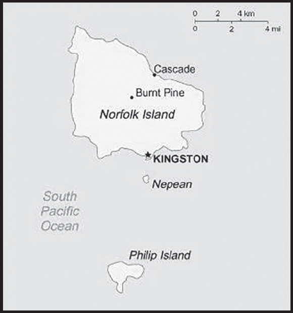
INTRODUCTION
Background: Polynesians lived on Norfolk Island between 1200 and 1500 but the remote island was uninhabited by the time British explorer James COOK landed on the island in 1774. Two British attempts at establishing the island as a penal colony (1788-1814 and 1825-55) were ultimately abandoned.
In 1856, almost 200 Pitcairn Islanders - descendants of the Bounty mutineers and their Tahitian companions - were relocated to Norfolk Island because of overcrowding on the Pitcairn Islands. Some returned to the Pitcairn Islands over the next few years but most settled permanently on Norfolk Island and recreated the land tenure and governance structures they previously had. Norfolk Island retained a great degree of local control until 1897, when it became a dependency of New South Wales. During World War II, Norfolk Island was an airbase and an important refueling stop in the South Pacific. In 1976, an Australian judge recommended Norfolk Island be incorporated fully into Australia, which Norfolk Islanders rejected. Following an appeal to the UN, Australia granted limited self-government to Norfolk Island in 1979.
With growing financial troubles during the 2000s, Australia abolished the Norfolk Island Legislative Assembly in 2015, reduced Norfolk Island’s autonomy in 2016, and suspended the local council in 2020. Most services are provided by a mix of the Australian Capital Territory and the states of New South Wales and Queensland. These moves were unpopular on Norfolk Island, which has sought to have its self-government restored.
GEOGRAPHY
Location: Oceania, island in the South Pacific Ocean, east of Australia
Geographic coordinates: 29 02 S, 167 57 E
Map references: Oceania
Area: total: 36 sq km
land: 36 sq km
water: 0 sq km
comparison ranking: total 234
Area - comparative: about 0.2 times the size of Washington, DC
Land boundaries: total: 0 km
Coastline: 32 km
Maritime claims: territorial sea: 12 nm
contiguous zone: 24 nm
exclusive fishing zone: 200 nm
Climate: subtropical; mild, little seasonal temperature variation
Terrain: volcanic island with mostly rolling plains
Elevation: highest point: Mount Bates 319 m
lowest point: Pacific Ocean 0 m
Natural resources: fish
Land use: agricultural land: 25% (2018 est.)
arable land: 0% (2018 est.)
permanent crops: 0% (2018 est.)
permanent pasture: 25% (2018 est.)
forest: 11.5% (2018 est.)
other: 63.5% (2018 est.)
Irrigated land: 0 sq km (2022)
Population distribution: population concentrated around the capital of Kingston
Natural hazards: tropical cyclones (especially May to July)
Geography - note: most of the 32 km coastline consists of almost inaccessible cliffs, but the land slopes down to the sea in one small southern area on Sydney Bay, where the capital of Kingston is situated
PEOPLE AND SOCIETY
Population: 1,748 (2016 est.)
comparison ranking: 232
Nationality: noun: Norfolk Islander(s)
adjective: Norfolk Islander(s)
Ethnic groups: Australian 22.8%, English 22.4%, Pitcairn Islander 20%, Scottish 6%, Irish 5.2%
(2011 est.)
note: respondents were able to identify up to two ancestries; percentages represent a proportion of all responses from people in Norfolk Island, including those who did not identify an ancestry; only top responses are shown
Languages: English (official) 44.9%, Norfolk (official; also known as Norfuk or Norf’k, which is a mixture of 18th century English and ancient Tahitian) 40.3%, Fijian 1.8%, other 6.8%, unspecified 6.2% (2016 est.)
note: data represent language spoken at home
Religions: Protestant 46.8% (Anglican 29.2%, Uniting Church in Australia 9.8%, Presbyterian 2.9%, Seventh Day Adventist 2.7%, other 2.2%), Roman Catholic 12.6%, other Christian 2.9%, other 1.4%, none 26.7%, unspecified 9.5% (2016 est.)
Population growth rate: 0.01% (2014 est.)
comparison ranking: 192
Population distribution: population concentrated around the capital of Kingston
ENVIRONMENT
Environment - current issues: inadequate solid waste management; most freshwater obtained through rainwater catchment; preservation of unique ecosystem
Climate: subtropical; mild, little seasonal temperature variation
Land use: agricultural land: 25% (2018 est.)
arable land: 0% (2018 est.)
permanent crops: 0% (2018 est.)
permanent pasture: 25% (2018 est.)
forest: 11.5% (2018 est.)
other: 63.5% (2018 est.)
GOVERNMENT
Country name: conventional long form: Territory of Norfolk Island
conventional short form: Norfolk Island
etymology: named by British explorer Captain James COOK after Mary HOWARD, Duchess of Norfolk, in 1774
Government type: non-self-governing overseas territory of Australia; note - the Norfolk Island Regional Council, which began operations 1 July 2016, is responsible for planning and managing a variety of public services, including those funded by the Government of Australia
Dependency status: self-governing territory of Australia; administered from Canberra by the Department of Infrastructure, Transport, Cities & Regional Development
Capital: name: Kingston
geographic coordinates: 29 03 S, 167 58 E
time difference: UTC+11 (16 hours ahead of Washington, DC, during Standard Time)
daylight saving time: +1hr, begins first Sunday in October; ends first Sunday in April
etymology: the name is a blending of the words “king’s” and “town”; the British king at the time of the town’s settlement in the late 18th century was GEORGE III
Administrative divisions: none (territory of Australia)
Independence: none (territory of Australia)
National holiday: Bounty Day (commemorates the arrival of Pitcairn Islanders), 8 June (1856)
Constitution: history: previous 1913, 1957; latest effective 7 August 1979
amendments: amended many times, last in 2020
Legal system: English common law and the laws of Australia
Citizenship: see Australia
Suffrage: 18 years of age; universal
Executive branch: chief of state: King CHARLES III (since 8 September 2022); represented by Governor General of the Commonwealth of Australia General David HURLEY (since 1 July 2019)
head of government: Administrator Eric HUTCHINSON (since 1 April 2017)
cabinet: Executive Council consists of 4 Legislative Assembly members
elections/appointments: the monarchy is hereditary; governor general appointed by the monarch; administrator appointed by the governor general of Australia for a 2-year term and represents the monarch and Australia
Legislative branch: description: unicameral Norfolk Island Regional Council (5 seats; councillors directly elected by simple majority vote to serve 4-year terms); mayor elected annually by the councillors
elections: last held on 28 May 2016 (next originally scheduled for 13 March 2021 was postponed); note - on 6 December 2021, the councillors of the Norfolk Island Regional Council were formally dismissed by the assistant minister and appointed as Administrator of the Council until 2024
election results: seats by party - independent 5; composition - men 4, women 1, percent of women 20%
Judicial branch: highest court(s): Supreme Court of Norfolk Island (consists of the chief justice and several justices); note - appeals beyond the Supreme Court of Norfolk Island are heard by the Federal Court and the High Court of Australia
judge selection and term of office: justices appointed by the governor general of Australia from among justices of the Federal Court of Australia; justices serve until mandatory retirement at age 70
subordinate courts: Petty Court of Sessions; specialized courts, including a Coroner’s Court and the Employment Tribunal
Political parties and leaders: Norfolk Island Labor Party [Mike KELLY]
Norfolk Liberals [John BROWN]
International organization participation: UPU
Diplomatic representation in the US: none (territory of Australia)
Diplomatic representation from the US: embassy: none (territory of Australia)
Flag description: three vertical bands of green (hoist side), white, and green with a large green Norfolk Island pine tree centered in the slightly wider white band; green stands for the rich vegetation on the island, and the pine tree - endemic to the island - is a symbol of Norfolk Island
note: somewhat reminiscent of the flag of Canada with its use of only two colors and depiction of a prominent local floral symbol in the central white band; also resembles the green and white triband of Nigeria
National symbol(s): Norfolk Island pine
National anthem: name: “Come Ye Blessed”
lyrics/music: New Testament/John Prindle SCOTT
note: the local anthem, whose lyrics consist of the words from Matthew 25:34-36, 40, is also known as “The Pitcairn Anthem;” the island does not recognize “Advance Australia Fair” (which other Australian territories use); instead “God Save the King” is official (see United Kingdom)
ECONOMY
Economic overview: high-income Australian territorial economy; key tourism and re-exportation industries; small labor force and declining participation creating more part-time jobs; former tax haven; increasing medical cannabis exporter; little transportation infrastructure
Real GDP (purchasing power parity): NA
Agricultural products: Norfolk Island pine seed, Kentia palm seed, cereals, vegetables, fruit; cattle, poultry
Industries: tourism, light industry, ready mixed concrete
Labor force: 978 (2006)
comparison ranking: 230
Labor force - by occupation: agriculture: 6%
industry: 14%
services: 80% (2006 est.)
Budget: revenues: $4.6 million (FY99/00)
expenditures: $4.8 million (FY99/00)
Fiscal year: 1 July - 30 June
Exports: NA
Exports - partners: Philippines 29%, Singapore 21%, India 14%, Belgium 7%, Australia 5%, Canada 5% (2019)
Exports - commodities: pine seeds, lumber, cars and vehicle parts, soybeans, lactose syrup, cleaning products, scrap aluminum (2021)
Imports: $NA
Imports - partners: New Zealand 23%, Australia 19%, Philippines 19%, Singapore 14%, Fiji 11% (2019)
Imports - commodities: clothing and apparel, chemical analysis instruments, refined petroleum, cars, kitchen machinery (2019)
Debt - external: NA
Exchange rates: Australian dollars (AUD) per US dollar -
Exchange rates: 1.311 (2017 est.)
1.3291 (2016 est.)
1.3291 (2015)
1.3291 (2014 est.)
1.1094 (2013 est.)
COMMUNICATIONS
Telecommunication systems: general assessment: the current infrastructure consists of fixed line telephone utilizing copper twisted pair cable and optic fiber, two Satellite Earth Station, GSM Mobile switch with five remote base stations and 2 micro cells, central public exchange which switches international as well as national calls, ADSL Broadband internet connection (Asynchronous Digital Subscriber Line), and an ISP (Internet Service Provider); 3G/4G telecommunications network went live on Tuesday 12 January, 2021 (2021)
domestic: free local calls
international: country code - 672; submarine cable links with Australia and New Zealand; satellite earth station - 1
Broadcast media: 1 local radio station; broadcasts of several Australian radio and TV stations available via satellite (2009)
Internet country code: .nf
Internet users: total: 806 (2021 est.)
percent of population: 46.1% (2021 est.)
comparison ranking: total 230
TRANSPORTATION
Airports: 1 (2021)
comparison ranking: total 214
Airports - with paved runways: 1
note: paved runways have a concrete or asphalt surface but not all have facilities for refueling, maintenance, or air traffic control; the length of a runway required for aircraft to safely operate depends on a number of factors including the type of aircraft, the takeoff weight (including passengers, cargo, and fuel), engine types, flap settings, landing speed, elevation of the airport, and average maximum daily air temperature; paved runways can reach a length of 5,000 m (16,000 ft.), but the “typical” length of a commercial airline runway is between 2,500-4,000 m (8,000-13,000 ft.)
Roadways: total: 80 km (2008)
paved: 53 km (2008)
unpaved: 27 km (2008)
comparison ranking: total 215
Ports and terminals: major seaport(s): Kingston
MILITARY AND SECURITY
Military - note: defense is the responsibility of Australia
TRANSNATIONAL ISSUES
Disputes - international: none identified
NORTH MACEDONIA
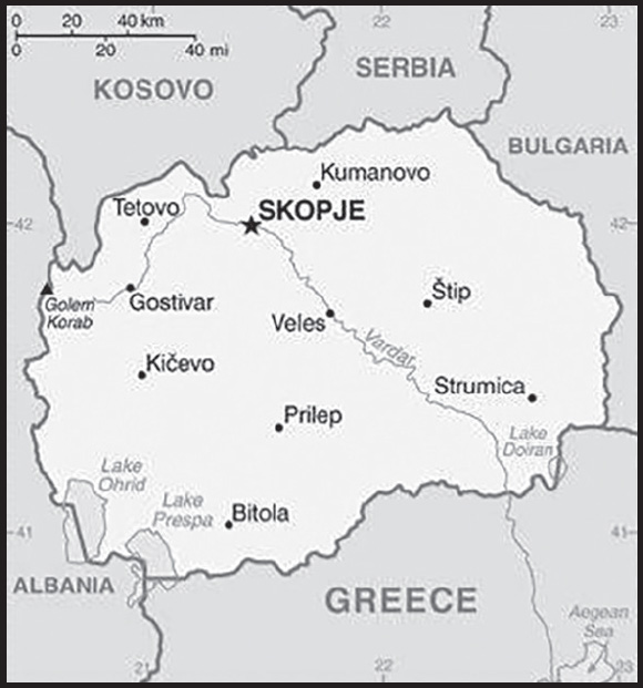
INTRODUCTION
Background: North Macedonia gained its independence peacefully from Yugoslavia in 1991 under the name of “Macedonia.” Greek objection to the new country’s name, insisting it implied territorial pretensions to the northern Greek province of Macedonia, and democratic backsliding for several years stalled the country’s movement toward Euro-Atlantic integration. Immediately after Macedonia declared independence, Greece sought to block Macedonian efforts to gain UN membership if the name “Macedonia” was used. The country was eventually admitted to the UN in 1993 as “The former Yugoslav Republic of Macedonia,” and at the same time it agreed to UN-sponsored negotiations on the name dispute. In 1995, Greece lifted a 20-month trade embargo and the two countries agreed to normalize relations, but the issue of the name remained unresolved and negotiations for a solution continued. Over time, the US and over 130 other nations recognized Macedonia by its constitutional name, Republic of Macedonia. Ethnic Albanian grievances over perceived political and economic inequities escalated into a conflict in 2001 that eventually led to the internationally brokered Ohrid Framework Agreement, which ended the fighting and established guidelines for constitutional amendments and the creation of new laws that enhanced the rights of minorities. In January 2018, the government adopted a new law on languages, which elevated the Albanian language to an official language at the national level, with the Macedonian language remaining the sole official language in international relations. Relations between ethnic Macedonians and ethnic Albanians remain complicated, however.
In June 2018, Macedonia and Greece signed the Prespa Agreement whereby Macedonia agreed to change its name to North Macedonia. Following ratification by both countries, the agreement went in to force on 12 February 2019. North Macedonia then joined NATO in 2020 after amending its constitution per the deal and opened EU accession talks in 2022 after a two-year veto by Bulgaria over identity, language, and historical disputes. North Macedonia has been an EU candidate since 2005. A nearly three-year political crisis from 2014 to 2017 began after the 2014 legislative and presidential election, and escalated in 2015 when the opposition party began releasing wiretapped material that revealed alleged widespread government corruption and abuse. The country still faces challenges, including fully implementing reforms to overcome years of democratic backsliding, stimulating economic growth and development, and fighting organized crime and corruption.
GEOGRAPHY
Location: Southeastern Europe, north of Greece
Geographic coordinates: 41 50 N, 22 00 E
Map references: Europe
Area: total: 25,713 sq km
land: 25,433 sq km
water: 280 sq km
comparison ranking: total 149
Area - comparative: slightly larger than Vermont; almost four times the size of Delaware
Land boundaries: total: 838 km
border countries (5): Albania 181 km; Bulgaria 162 km; Greece 234 km; Kosovo 160 km; Serbia 101 km
Coastline: 0 km (landlocked)
Maritime claims: none (landlocked)
Climate: warm, dry summers and autumns; relatively cold winters with heavy snowfall
Terrain: mountainous with deep basins and valleys; three large lakes, each divided by a frontier line; country bisected by the Vardar River
Elevation: highest point: Golem Korab (Maja e Korabit) 2,764 m
lowest point: Vardar River 50 m
mean elevation: 741 m
Natural resources: low-grade iron ore, copper, lead, zinc, chromite, manganese, nickel, tungsten, gold, silver, asbestos, gypsum, timber, arable land
Land use: agricultural land: 44.3% (2018 est.)
arable land: 16.4% (2018 est.)
permanent crops: 1.4% (2018 est.)
permanent pasture: 26.5% (2018 est.)
forest: 39.8% (2018 est.)
other: 15.9% (2018 est.)
Irrigated land: 844 sq km (2016)
Major watersheds (area sq km): Atlantic Ocean drainage: (Black Sea) Danube (795,656 sq km)
Population distribution: a fairly even distribution throughout most of the country, with urban areas attracting larger and denser populations
Natural hazards: high seismic risks
Geography - note: landlocked; major transportation corridor from Western and Central Europe to Aegean Sea and Southern Europe to Western Europe
PEOPLE AND SOCIETY
Population: 2,133,410 (2023 est.)
comparison ranking: 148
Nationality: noun: Macedonian(s)
adjective: Macedonian
Ethnic groups: Macedonian 58.4%, Albanian 24.3%, Turkish 3.9%, Romani 2.5%, Serb 1.3%, other 2.3%, persons for whom data were taken from administrative sources and no ethnic affiliation data was available 7.2% (2021 est.)
note: data represent total resident population; Romani populations are usually underestimated in official statistics and may represent 6.5–13% of North Macedonia’s population
Languages: Macedonian (official) 61.4%, Albanian (official) 24.3%, Turkish 3.4%, Romani 1.7%, other (includes Aromanian (Vlach) and Bosnian) 2%, persons for whom data were taken from administrative sources and no language data was available 7.2% (2021 est.); note - data represent mother tongue; minority languages are co-official with Macedonian in municipalities where they are spoken by at least 20% of the population; Albanian is co-official in Tetovo, Brvenica, Vrapciste, and other municipalities; Turkish is co-official in Centar Zupa and Plasnica; Romani is co-official in Suto Orizari; Aromanian is co-official in Krusevo; Serbian is co-official in Cucer Sandevo
major-language sample(s):

(Macedonian)
Religions: Macedonian Orthodox 46.1%, Muslim 32.2%, other Christian 13.8%, other and non-believers 0.5%, unspecified 0.2%, persons for whom data were taken from administrative sources and no religious affiliation data was available 7.2% (2021 est.)
Age structure: 0-14 years: 16.06% (male 177,156/female 165,540)
15-64 years: 68.69% (male 742,990/female 722,359)
65 years and over: 15.25% (2023 est.) (male 143,539/female 181,826)
Dependency ratios: total dependency ratio: 44.6
youth dependency ratio: 23.2
elderly dependency ratio: 21.4
potential support ratio: 4.7 (2021 est.)
Median age: total: 39 years (2020)
male: 38 years
female: 40 years
comparison ranking: total 59
Population growth rate: 0.11% (2023 est.)
comparison ranking: 186
Birth rate: 10.33 births/1,000 population (2023 est.)
comparison ranking: 181
Death rate: 9.61 deaths/1,000 population (2023 est.)
comparison ranking: 41
Net migration rate: 0.38 migrant(s)/1,000 population (2023 est.)
comparison ranking: 74
Population distribution: a fairly even distribution throughout most of the country, with urban areas attracting larger and denser populations
Urbanization: urban population: 59.5% of total population (2023)
rate of urbanization: 0.61% annual rate of change (2020-25 est.)
Major urban areas - population: 611,000 SKOPJE (capital) (2023)
Sex ratio: at birth: 1.07 male(s)/female
0-14 years: 1.07 male(s)/female
15-64 years: 1.03 male(s)/female
65 years and over: 0.79 male(s)/female
total population: 0.99 male(s)/female (2023 est.)
Mother’s mean age at first birth: 26.9 years (2020 est.)
Maternal mortality ratio: 3 deaths/100,000 live births (2020 est.)
comparison ranking: 179
Infant mortality rate: total: 7.16 deaths/1,000 live births (2023 est.)
male: 8.09 deaths/1,000 live births
female: 6.17 deaths/1,000 live births
comparison ranking: total 158
Life expectancy at birth: total population: 77.09 years (2023 est.)
male: 74.99 years
female: 79.32 years
comparison ranking: total population 98
Total fertility rate: 1.52 children born/woman (2023 est.)
comparison ranking: 199
Gross reproduction rate: 0.74 (2023 est.)
Contraceptive prevalence rate: 59.9% (2018/19)
Drinking water source: improved: urban: 99.7% of population
rural: 99% of population
total: 99.4% of population
unimproved: urban: 0.3% of population
rural: 1% of population
total: 0.6% of population (2020 est.)
Current health expenditure: 7.9% of GDP (2020)
Physicians density: 2.87 physicians/1,000 population (2015)
Hospital bed density: 4.3 beds/1,000 population (2017)
Sanitation facility access: improved: urban: 100% of population
rural: 98% of population
total: 99.2% of population
unimproved: urban: 0% of population
rural: 2% of population
total: 0.8% of population (2020 est.)
Obesity - adult prevalence rate: 22.4% (2016)
comparison ranking: 77
Alcohol consumption per capita: total: 3.9 liters of pure alcohol (2019 est.)
beer: 1.93 liters of pure alcohol (2019 est.)
wine: 1.03 liters of pure alcohol (2019 est.)
spirits: 0.9 liters of pure alcohol (2019 est.)
other alcohols: 0.03 liters of pure alcohol (2019 est.)
comparison ranking: total 97
Children under the age of 5 years underweight: 0.9% (2018/19)
comparison ranking: 119
Currently married women (ages 15-49): 66.5% (2023 est.)
Child marriage: women married by age 15: 0.3%
women married by age 18: 7.5% (2019 est.)
Literacy: definition: age 15 and over can read and write
total population: 98.4%
male: 99.1%
female: 97.6% (2020)
School life expectancy (primary to tertiary education): total: 13 years
male: 13 years
female: 14 years (2020)
Youth unemployment rate (ages 15-24): total: 34.1% (2021 est.)
male: 31.6%
female: 38.4%
comparison ranking: total 28
ENVIRONMENT
Environment - current issues: air pollution from metallurgical plants; Skopje has severe air pollution problems every winter as a result of industrial emissions, smoke from wood-buring stoves, and exhaust fumes from old cars
Environment - international agreements: party to: Air Pollution, Air Pollution-Heavy Metals, Air Pollution-Multi-effect Protocol, Air Pollution-Nitrogen Oxides, Air Pollution-Persistent Organic Pollutants, Air Pollution-Sulphur 85, Air Pollution-Sulphur 94, Air Pollution-Volatile Organic Compounds, Biodiversity, Climate Change, Climate Change-Kyoto Protocol, Climate Change-Paris Agreement, Comprehensive Nuclear Test Ban, Desertification, Endangered Species, Hazardous Wastes, Law of the Sea, Ozone Layer Protection, Wetlands
signed, but not ratified: none of the selected agreements
Climate: warm, dry summers and autumns; relatively cold winters with heavy snowfall
Land use: agricultural land: 44.3% (2018 est.)
arable land: 16.4% (2018 est.)
permanent crops: 1.4% (2018 est.)
permanent pasture: 26.5% (2018 est.)
forest: 39.8% (2018 est.)
other: 15.9% (2018 est.)
Urbanization: urban population: 59.5% of total population (2023)
rate of urbanization: 0.61% annual rate of change (2020-25 est.)
Revenue from forest resources: 0.15% of GDP (2018 est.)
comparison ranking: 100
Revenue from coal: 0% of GDP (2018 est.)
comparison ranking: 119
Air pollutants: particulate matter emissions: 25.17 micrograms per cubic meter (2019 est.)
carbon dioxide emissions: 7.05 megatons (2016 est.)
methane emissions: 2.28 megatons (2020 est.)
Waste and recycling: municipal solid waste generated annually: 796,585 tons (2016 est.)
municipal solid waste recycled annually: 1,434 tons (2013 est.)
percent of municipal solid waste recycled: 0.2% (2013 est.)
Major watersheds (area sq km): Atlantic Ocean drainage: (Black Sea) Danube (795,656 sq km)
Total water withdrawal: municipal: 310 million cubic meters (2020 est.)
industrial: 20 million cubic meters (2020 est.)
agricultural: 140 million cubic meters (2020 est.)
Total renewable water resources: 6.4 billion cubic meters (2020 est.)
GOVERNMENT
Country name: conventional long form: Republic of North Macedonia
conventional short form: North Macedonia
local long form: Republika Severna Makedonija
local short form: Severna Makedonija
former: Democratic Federal Macedonia, People’s Republic of Macedonia, Socialist Republic of Macedonia, Republic of Macedonia
etymology: the country name derives from the ancient kingdom of Macedon (7th to 2nd centuries B.C.)
Government type: parliamentary republic
Capital: name: Skopje
geographic coordinates: 42 00 N, 21 26 E
time difference: UTC+1 (6 hours ahead of Washington, DC, during Standard Time)
daylight saving time: +1hr, begins last Sunday in March; ends last Sunday in October
etymology: Skopje derives from its ancient name Scupi, the Latin designation of a classical era Greco-Roman frontier fortress town; the name may go back even further to a pre-Greek, Illyrian name
Administrative divisions: 70 municipalities (opstini, singular - opstina) and 1 city* (grad); Aracinovo, Berovo, Bitola, Bogdanci, Bogovinje, Bosilovo, Brvenica, Caska, Centar Zupa, Cesinovo-Oblesevo, Cucer Sandevo, Debar, Debarca, Delcevo, Demir Hisar, Demir Kapija, Dojran, Dolneni, Gevgelija, Gostivar, Gradsko, Ilinden, Jegunovce, Karbinci, Kavadarci, Kicevo, Kocani, Konce, Kratovo, Kriva Palanka, Krivogastani, Krusevo, Kumanovo, Lipkovo, Lozovo, Makedonska Kamenica, Makedonski Brod, Mavrovo i Rostuse, Mogila, Negotino, Novaci, Novo Selo, Ohrid, Pehcevo, Petrovec, Plasnica, Prilep, Probistip, Radovis, Rankovce, Resen, Rosoman, Skopje*, Sopiste, Staro Nagoricane, Stip, Struga, Strumica, Studenicani, Sveti Nikole, Tearce, Tetovo, Valandovo, Vasilevo, Veles, Vevcani, Vinica, Vrapciste, Zelenikovo, Zelino, Zrnovci
Independence: 8 September 1991 (referendum by registered voters endorsed independence from Yugoslavia)
National holiday: Independence Day, 8 September (1991), also known as National Day
Constitution: history: several previous; latest adopted 17 November 1991, effective 20 November 1991
amendments: proposed by the president of the republic, by the government, by at least 30 members of the Assembly, or by petition of at least 150,000 citizens; final approval requires a two-thirds majority vote by the Assembly; amended several times, last in 2019; this amendment was the result of the 2018 Prespa Agreement with Greece, in which the constitutional name of the country would be changed to the Republic of North Macedonia - previously the Republic of Macedonia - in exchange for assurances that Greece would no longer object to North Macedonia’s integration in international organizations
Legal system: civil law system; judicial review of legislative acts
International law organization participation: has not submitted an ICJ jurisdiction declaration; accepts ICCt jurisdiction
Citizenship: citizenship by birth: no
citizenship by descent only: at least one parent must be a citizen of North Macedonia
dual citizenship recognized: no
residency requirement for naturalization: 8 years
Suffrage: 18 years of age; universal
Executive branch: chief of state: President Stevo PENDAROVSKI (since 12 May 2019)
head of government: Prime Minister Dimitar KOVACEVSKI (since 16 January 2022)
cabinet: Council of Ministers elected by the Assembly by simple majority vote
elections/appointments: president directly elected using a modified 2-round system; a candidate can only be elected in the first round with an absolute majority from all registered voters; in the second round, voter turnout must be at least 40% for the result to be deemed valid; president elected for a 5-year term (eligible for a second term); election last held on 21 April and 5 May 2019 (next to be held in 2024); following legislative elections, the leader of the majority party or majority coalition is usually elected prime minister by the Assembly; Dimitar KOVACEVSKI elected prime minister by the Assembly on 16 January 2022; Assembly vote - NA
election results: 2019: Stevo PENDAROVSKI elected president in second round; percent of vote in first round - Stevo PENDAROVSKI (SDSM) 44.8%, Gordana SILJANOVSKA-DAVKOVA (VMRO-DPMNE) 44.2%, Blenim REKA (independent) 11.1%; percent of vote in second round - Stevo PENDAROVSKI 53.6%, Gordana SILJANOVSKA-DAVKOVA 46.4%
2014: Gjorge IVANOV reelected president in second round; percent of vote in first round - Gjorge IVANOV (VMRO-DPMNE) 53.1%, Stevo PENDAROVSKI (SDSM) 38.6%, Ilijaz HALIMI (DPA) 4.6%, Zoran POPOVSKI (GROM) 3.7%; percent of vote in second round - Gjorge IVANOV 57.3%, Stevo PENDAROVSKI 42.7%
Legislative branch: description: unicameral Assembly - Sobraine in Macedonian, Kuvend in Albanian (between 120 and 140 seats, currently 120; members directly elected in multi-seat constituencies by closed-list proportional representation vote; possibility of 3 directly elected in diaspora constituencies by simple majority vote provided there is sufficient voter turnout; members serve 4-year terms)
elections: last held on 15 July 2020 (next to be held in 2024)
election results: percent of vote by party/coalition - We Can 35.9%, Renewal 34.6%, BDI 11.5%, AfA-Alternative 9%, The Left 4.1%, PDSh 1.5%, other 3.4%; seats by party/coalition - We Can 46, Renewal 44, BDI 15, AfA-Alternative 12, The Left 2, PDSh 1; composition - men 70, women 50, percent of women 41.7%
Judicial branch: highest court(s): Supreme Court (consists of 22 judges); Constitutional Court (consists of 9 judges)
judge selection and term of office: Supreme Court judges nominated by the Judicial Council, a 7-member body of legal professionals, and appointed by the Assembly; judge tenure NA; Constitutional Court judges appointed by the Assembly for nonrenewable, 9-year terms
subordinate courts: Courts of Appeal; Basic Courts
Political parties and leaders: Alliance for Albanians or AfA [Ziadin SELA]
Alternative (Alternativa) [Afrim GASHI]
Besa Movement [Bilal KASAMI]
Democratic Party of Albanians or PDSh [Menduh THACI]
Democratic Union for Integration or BDI [Ali AHMETI]
Internal Macedonian Revolutionary Organization - Democratic Party for Macedonian National Unity or VMRO-DPMNE [Hristijan MICKOSKI]
Internal Macedonian Revolutionary Organization - People’s Party or VMRO-NP [Ljubco GEORGIEVSKI]
Liberal Democratic Party or LDP [Goran MILEVSKI]
Renewal [Maja MORACHANIN]
Social Democratic Union of Macedonia or SDSM [Dimitar KOVACHEVSKI]
The Left (Levica) [Dimitar APASIEV]
Turkish Democratic Party of DPT [Beycan ILYAS]
We Can (coalition includes SDSM/Besa/VMRO-NP, DPT, LDP)
International organization participation: BIS, CD, CE, CEI, EAPC, EBRD, EU (candidate country), FAO, IAEA, IBRD, ICAO, ICC (NGOs), ICCt, ICRM, IDA, IFAD, IFC, IFRCS, ILO, IMF, IMO, Interpol, IOC, IOM, IPU, ISO, ITU, ITUC (NGOs), MIGA, NATO, OAS (observer), OIF, OPCW, OSCE, PCA, PFP, SELEC, UN, UNCTAD, UNESCO, UNHCR, UNIDO, UNIFIL, UNWTO, UPU, WCO, WHO, WIPO, WMO, WTO
note: North Macedonia is an EU candidate country whose satisfactory completion of accession criteria is required before being granted full EU membership
Diplomatic representation in the US: chief of mission: Ambassador Zoran POPOV (since 16 September 2022)
chancery: 2129 Wyoming Avenue NW, Washington, DC 20008
telephone: [1] (202) 667-0501
FAX: [1] (202) 667-2131
email address and website:
consulate(s) general: Chicago, Detroit, New York
Diplomatic representation from the US: chief of mission: Ambassador Angela AGGELER (since 8 November 2022)
embassy: Str. Samoilova, Nr. 21, 1000 Skopje
mailing address: 7120 Skopje Place, Washington, DC 20521-7120
telephone: [389] (2) 310-2000
FAX: [389] (2) 310-2499
email address and website:
Flag description: a yellow sun (the Sun of Liberty) with eight broadening rays extending to the edges of the red field; the red and yellow colors have long been associated with Macedonia
National symbol(s): eight-rayed sun; national colors: red, yellow
National anthem: name: “Denes nad Makedonija” (Today Over Macedonia)
lyrics/music: Vlado MALESKI/Todor SKALOVSKI
note: written in 1943 and adopted in 1991, the song previously served as the anthem of the Socialist Republic of Macedonia while part of Yugoslavia
National heritage: total World Heritage Sites: 2 (both natural)
selected World Heritage Site locales: Natural and Cultural Heritage of the Ohrid Region; Ancient and Primeval Beech Forests of the Carpathians
ECONOMY
Economic overview: growing upper middle-income European economy; EU accession stalled due to Bulgarian dispute; new NATO member; private consumption-driven growth; investment declined due to COVID-19; regional economic power gains since Greek naming resolution
Real GDP (purchasing power parity): $34.007 billion (2021 est.)
$32.71 billion (2020 est.)
$34.839 billion (2019 est.)
note: data are in 2017 dollars; Macedonia has a large informal sector that may not be reflected in these data
comparison ranking: 133
Real GDP growth rate: 3.96% (2021 est.)
-6.11% (2020 est.)
3.91% (2019 est.)
comparison ranking: 122
Real GDP per capita: $16,500 (2021 est.)
$15,800 (2020 est.)
$16,800 (2019 est.)
note: data are in 2017 dollars
comparison ranking: 102
GDP (official exchange rate): $12.696 billion (2019 est.)
Inflation rate (consumer prices): 3.23% (2021 est.)
1.2% (2020 est.)
0.77% (2019 est.)
comparison ranking: 117
Credit ratings: Fitch rating: BB+ (2019)
Standard & Poors rating: BB- (2013)
note: The year refers to the year in which the current credit rating was first obtained.
GDP - composition, by sector of origin: agriculture: 10.9% (2017 est.)
industry: 26.6% (2017 est.)
services: 62.5% (2017 est.)
comparison rankings: services 104; industry 100; agriculture 85
GDP - composition, by end use: household consumption: 65.6% (2017 est.)
government consumption: 15.6% (2017 est.)
investment in fixed capital: 13.6% (2017 est.)
investment in inventories: 20.2% (2017 est.)
exports of goods and services: 54% (2017 est.)
imports of goods and services: -69% (2017 est.)
Agricultural products: milk, grapes, wheat, potatoes, green chillies/peppers, cabbages, tomatoes, maize, barley, watermelons
Industries: food processing, beverages, textiles, chemicals, iron, steel, cement, energy, pharmaceuticals, automotive parts
Industrial production growth rate: -2.37% (2021 est.)
comparison ranking: 177
Labor force: 916,200 (2021 est.)
comparison ranking: 148
Labor force - by occupation: agriculture: 16.2%
industry: 29.2%
services: 54.5% (2017 est.)
Unemployment rate: 16.2% (2021 est.)
17.2% (2020 est.)
17.26% (2019 est.)
comparison ranking: 30
Youth unemployment rate (ages 15-24): total: 34.1% (2021 est.)
male: 31.6%
female: 38.4%
comparison ranking: total 28
Population below poverty line: 21.6% (2018 est.)
Gini Index coefficient - distribution of family income: 33 (2018 est.)
comparison ranking: 124
Average household expenditures: on food: 30.8% of household expenditures (2018 est.)
on alcohol and tobacco: 7.3% of household expenditures (2018 est.)
Household income or consumption by percentage share: lowest 10%: 1.7%
highest 10%: 25% (2015 est.)
Budget: revenues: $3.505 billion (2020 est.)
expenditures: $4.5 billion (2020 est.)
Budget surplus (+) or deficit (-): -2.7% (of GDP) (2017 est.)
comparison ranking: 119
Public debt: 39.3% of GDP (2017 est.)
39.5% of GDP (2016 est.)
note: official data from Ministry of Finance; data cover central government debt; this data excludes debt instruments issued (or owned) by government entities other than the treasury; includes treasury debt held by foreign entitites; excludes debt issued by sub-national entities; there are no debt instruments sold for social funds
comparison ranking: 138
Taxes and other revenues: 16.13% (of GDP) (2020 est.)
comparison ranking: 135
Fiscal year: calendar year
Current account balance: -$420.178 million (2021 est.)
-$360.444 million (2020 est.)
-$376.487 million (2019 est.)
comparison ranking: 115
Exports: $9.157 billion (2021 est.) note: data are in current year dollars
$7.19 billion (2020 est.) note: data are in current year dollars
$7.8 billion (2019 est.) note: data are in current year dollars
comparison ranking: 109
Exports - partners: Germany 45%, Serbia 8%, Bulgaria 5% (2019)
Exports - commodities: support catalysts, centrifuges, insulated wiring, iron alloys, seats (2021)
Imports: $11.354 billion (2021 est.) note: data are in current year dollars
$8.773 billion (2020 est.) note: data are in current year dollars
$9.605 billion (2019 est.) note: data are in current year dollars
comparison ranking: 105
Imports - partners: United Kingdom 14%, Germany 14%, Greece 8%, Serbia 8% (2019)
Imports - commodities: platinum, refined petroleum, laboratory ceramics, cars, insulated wiring (2019)
Reserves of foreign exchange and gold: $4.129 billion (31 December 2021 est.)
$4.126 billion (31 December 2020 est.)
$3.651 billion (31 December 2019 est.)
comparison ranking: 108
Debt - external: $9.065 billion (2019 est.)
$9.398 billion (2018 est.)
comparison ranking: 117
Exchange rates: Macedonian denars (MKD) per US dollar -
Exchange rates: 52.102 (2021 est.)
54.144 (2020 est.)
54.947 (2019 est.)
52.107 (2018 est.)
54.665 (2017 est.)
ENERGY
Electricity access: electrification - total population: 100% (2021)
Electricity: installed generating capacity: 1.928 million kW (2020 est.)
consumption: 6,350,982,000 kWh (2019 est.)
exports: 639 million kWh (2020 est.)
imports: 2.965 billion kWh (2020 est.)
transmission/distribution losses: 979 million kWh (2019 est.)
comparison rankings: imports 53; exports 70; installed generating capacity 119; transmission/distribution losses 112; consumption 116
Electricity generation sources: fossil fuels: 71.4% of total installed capacity (2020 est.)
solar: 0.5% of total installed capacity (2020 est.)
wind: 2.3% of total installed capacity (2020 est.)
hydroelectricity: 24.7% of total installed capacity (2020 est.)
biomass and waste: 1.1% of total installed capacity (2020 est.)
Coal: production: 5.026 million metric tons (2020 est.)
consumption: 5.211 million metric tons (2020 est.)
exports: 1,000 metric tons (2020 est.)
imports: 174,000 metric tons (2020 est.)
proven reserves: 332 million metric tons (2019 est.)
Petroleum: total petroleum production: 0 bbl/day (2021 est.)
refined petroleum consumption: 22,700 bbl/day (2019 est.)
Refined petroleum products - exports: 3,065 bbl/day (2015 est.)
comparison ranking: 99
Refined petroleum products - imports: 23,560 bbl/day (2015 est.)
comparison ranking: 111
Natural gas: production: 0 cubic meters (2021 est.)
consumption: 218.917 million cubic meters (2019 est.)
exports: 0 cubic meters (2021 est.)
imports: 218.917 million cubic meters (2019 est.)
proven reserves: 0 cubic meters (2021 est.)
Carbon dioxide emissions: 7.383 million metric tonnes of CO2 (2019 est.)
from coal and metallurgical coke: 3.866 million metric tonnes of CO2 (2019 est.)
from petroleum and other liquids: 3.094 million metric tonnes of CO2 (2019 est.)
from consumed natural gas: 423,000 metric tonnes of CO2 (2019 est.)
comparison ranking: total emissions 123
Energy consumption per capita: 53.572 million Btu/person (2019 est.)
comparison ranking: 96
COMMUNICATIONS
Telephones - fixed lines: total subscriptions: 425,646 (2021 est.)
subscriptions per 100 inhabitants: 20 (2021 est.)
comparison ranking: total subscriptions 100
Telephones - mobile cellular: total subscriptions: 1,941,352 (2021 est.)
subscriptions per 100 inhabitants: 92 (2021 est.)
comparison ranking: total subscriptions 152
Telecommunication systems: general assessment: as part of the EU pre-accession process, North Macedonia has built closer economic ties with the Union which accounts for 77.5% of Macedonia’s exports and just over half of its imports; closer regulatory and administrative ties with European Commission (EC) institutions have done much to develop the telecom sector and prepare the market for the competitive environment encouraged in the EU; as part of EU integration legislation North Macedonia has implemented the principles of the EU’s regulatory framework for communications, established an independent regulator and set out several provisions to provide for a competitive telecom market, including wholesale access to the incumbent’s fixed-line network; broadband services are widely available, with effective competition between DSL and cable platforms complemented by wireless broadband and a developing fiber sector; the number of DSL subscribers has continued to fall in recent years as customers are migrated to fiber networks; the MNOs are increasingly focused on expanding their 5G networks, seeking stronger coverage across North Macedonia’s high value urban areas; mobile data services are also becoming increasingly important following investments in LTE network rollouts and in upgrades to LTE-A technology (2022)
domestic: fixed-line roughly 20 per 100 and mobile-cellular 92 per 100 subscriptions (2021)
international: country code - 389
Broadcast media: public service TV broadcaster Macedonian Radio and Television operates 3 national terrestrial TV channels and 2 satellite TV channels; additionally, there are 10 regional TV stations that broadcast nationally using terrestrial transmitters, 54 TV channels with concession for cable TV, 9 regional TV stations with concessions for cable TV; 4 satellite TV channels broadcasting on a national level, 21 local commercial TV channels, and a large number of cable operators that offer domestic and international programming; the public radio broadcaster operates over 3 stations; there are 4 privately owned radio stations that broadcast nationally; 17 regional radio stations, and 49 local commercial radio stations (2019)
Internet country code: .mk
Internet users: total: 1.743 million (2021 est.)
percent of population: 83% (2021 est.)
comparison ranking: total 140
Broadband - fixed subscriptions: total: 475,569 (2020 est.)
subscriptions per 100 inhabitants: 23 (2020 est.)
comparison ranking: total 93
TRANSPORTATION
Civil aircraft registration country code prefix: Z3
Airports: 10 (2021)
comparison ranking: total 154
Airports - with paved runways: 8
note: paved runways have a concrete or asphalt surface but not all have facilities for refueling, maintenance, or air traffic control; the length of a runway required for aircraft to safely operate depends on a number of factors including the type of aircraft, the takeoff weight (including passengers, cargo, and fuel), engine types, flap settings, landing speed, elevation of the airport, and average maximum daily air temperature; paved runways can reach a length of 5,000 m (16,000 ft.), but the “typical” length of a commercial airline runway is between 2,500-4,000 m (8,000-13,000 ft.)
Airports - with unpaved runways: 2
note: unpaved runways have a surface composition such as grass or packed earth and are most suited to the operation of light aircraft; unpaved runways are usually short, often less than 1,000 m (3,280 ft.) in length; airports with unpaved runways often lack facilities for refueling, maintenance, or air traffic control
Pipelines: 262 km gas, 120 km oil (2017)
Railways: total: 699 km (2020) 313 km electrified
comparison ranking: total 99
Roadways: total: 14,182 km (2017) (includes 290 km of expressways)
paved: 9,633 km (2017)
unpaved: 4,549 km (2017)
comparison ranking: total 127
MILITARY AND SECURITY
Military and security forces: Army of the Republic of North Macedonia (ARSM): the ARSM is a joint force with air, ground, reserve, special operations, and support forces (2023)
note: the Police of Macedonia maintain internal security, including migration and border enforcement, and report to the Ministry of the Interior
Military expenditures: 1.9% of GDP (2023 est.)
1.6% of GDP (2022 est.)
1.5% of GDP (2021)
1.2% of GDP (2020)
1.2% of GDP (2019)
comparison ranking: 64
Military and security service personnel strengths: approximately 6,500 active-duty personnel (2023)
Military equipment inventories and acquisitions: the military’s inventory consists mostly of Soviet-era equipment, although in recent years it has received small amounts of more modern equipment from countries such as Turkey and the US (2022)
Military service age and obligation: 18 years of age for voluntary military service; conscription abolished in 2007 (2023)
note: as of 2023, women made up about 10% of the military’s full-time personnel
Military - note: the Army of the Republic of North Macedonia (ARSM) is responsible for the defense of the country’s territory and independence, fulfilling North Macedonia’s commitments to NATO and European security, and contributing to EU, NATO, and UN peace and security missions; the ARSM has participated in multinational missions and operations in Afghanistan (NATO), Bosnia and Herzegovina (EU), Eastern Europe (NATO), Iraq (NATO), Kosovo (NATO), and Lebanon (UN); a key area of focus over the past decade has been improving capabilities and bringing the largely Soviet-era-equipped ARSM up to NATO standards; it has increased its participation in NATO training exercises since becoming the 30th member of the Alliance in 2020 and currently has small numbers of combat troops deployed to Bulgaria and Romania as part of NATO’s Enhance Forward Presence mission implemented because of Russian military aggression against Ukraine
the ARSM is a joint force led by a general staff with subordinate commands for operations, logistics, reserves, special operations, and training; the Operational Command includes the active air and ground combat forces, which include a mechanized infantry brigade, an air brigade with a small combat helicopter squadron, and a ground air defense unit; the Special Operations Command has battalions of rangers and special forces, while the Reserve Forces Command has an infantry brigade (2023)
TERRORISM
Terrorist group(s): Terrorist group(s): Islamic State of Iraq and ash-Sham (ISIS)
note: details about the history, aims, leadership, organization, areas of operation, tactics, targets, weapons, size, and sources of support of the group(s) appear(s) in Appendix-T
TRANSNATIONAL ISSUES
Disputes - international: North Macedonia-Albania: none identified
North Macedonia-Greece: none identified
North Macedonia-Kosovo: North Macedonia and Kosovo completed demarcation of their boundary in October 2009
North Macedonia-Serbia: none identified
Refugees and internally displaced persons: refugees (country of origin): 18,345 (Ukraine) (as of 1 October 2023)
stateless persons: 521 (2022)
note: 562,235 estimated refugee and migrant arrivals (January 2015-October 2023)
Illicit drugs: major transshipment point for Southwest Asian heroin and hashish; minor transit point for South American cocaine destined for Europe; although not a financial center and most criminal activity is thought to be domestic, money laundering is a problem due to a mostly cash-based economy and weak enforcement
NORTHERN MARIANA ISLANDS
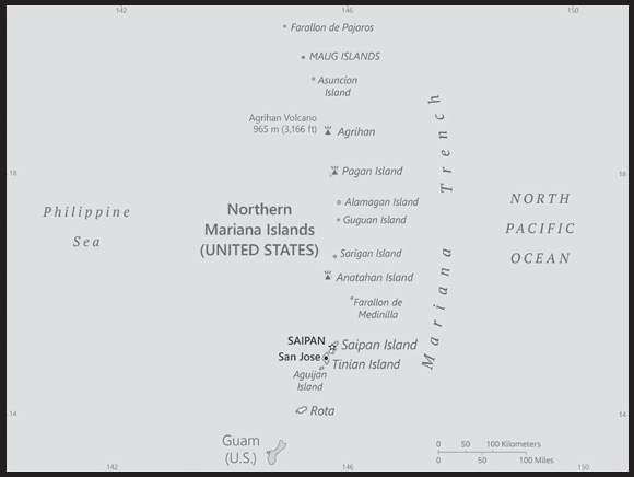
INTRODUCTION
Background: The Northern Mariana Islands were settled by Austronesian people around 1500 B.C. These people became the indigenous Chamorro and were influenced by later migrations, including of Micronesians in the first century A.D., and island Southeast Asians around 900. Spanish explorer Ferdinand MAGELLAN sailed through the Mariana Islands in 1521 and Spain claimed them in 1565. Spain formally colonized the Mariana Islands in 1668 and administered the archipelago from Guam. Spain’s brutal repression of the Chamorro, along with new diseases and intermittent warfare, reduced the indigenous population by about 90% in the 1700s. With a similar dynamic occurring on Guam, Spain forced the Chamorro from the Northern Mariana Islands to resettle on Guam and prevented them from returning to their home islands. By the time the Northern Mariana Islands’ Chamorro returned, many other Micronesians, including Chuukese and Yapese, had already settled on their islands.
In 1898, Spain ceded Guam to the US following the Spanish-American War but sold the Northern Mariana Islands to Germany under the German-Spanish Treaty of 1899. Germany administered the territory from German New Guinea but took a hands-off approach to day-to-day life. Following World War I, Japan administered the islands under a League of Nations mandate. Japan focused on sugar production and brought in thousands of Japanese laborers, who quickly outnumbered the Chamorro on the islands. During World War II, Japan invaded Guam from the Northern Mariana Islands and used Marianan Chamorro as translators with Guamanian Chamorro, creating friction between the two Chamorro communities that continues to this day. The US captured the Northern Mariana Islands in 1944 after the Battle of Saipan and administered them post-World War II as part of the Trust Territory of the Pacific Islands (TTPI).
On four occasions in the 1950s and 1960s, voters opted for integration with Guam, although Guam rejected it in 1969. In 1978, the Northern Mariana Islands was granted self-government separate from the rest of the TTPI and in 1986, islanders were granted US citizenship and the territory came under US sovereignty as the Commonwealth of the Northern Mariana Islands (CNMI). In 2009, the CNMI became the final US territory to elect a nonvoting delegate to the US Congress.
GEOGRAPHY
Location: Oceania, islands in the North Pacific Ocean, about three-quarters of the way from Hawaii to the Philippines
Geographic coordinates: 15 12 N, 145 45 E
Map references: Oceania
Area: total: 464 sq km
land: 464 sq km
water: 0 sq km
note: consists of 14 islands including Saipan, Rota, and Tinian
comparison ranking: total 196
Area - comparative: 2.5 times the size of Washington, DC
Land boundaries: total: 0 km
Coastline: 1,482 km
Maritime claims: territorial sea: 12 nm
exclusive economic zone: 200 nm
Climate: tropical marine; moderated by northeast trade winds, little seasonal temperature variation; dry season December to June, rainy season July to October
Terrain: the southern islands in this north-south trending archipelago are limestone, with fringing coral reefs; the northern islands are volcanic, with active volcanoes on several islands
Elevation: highest point: Agrihan Volcano 965 m
lowest point: Pacific Ocean 0 m
Natural resources: arable land, fish
Land use: agricultural land: 6.6% (2018 est.)
arable land: 2.2% (2018 est.)
permanent crops: 2.2% (2018 est.)
permanent pasture: 2.2% (2018 est.)
forest: 65.5% (2018 est.)
other: 27.9% (2018 est.)
Irrigated land: 1 sq km (2012)
Population distribution: approximately 90% of the population lives on the island of Saipan
Natural hazards: active volcanoes on Pagan and Agrihan; typhoons (especially August to November)
Geography - note: strategic location in the North Pacific Ocean
PEOPLE AND SOCIETY
Population: 51,295 (2023 est.)
comparison ranking: 209
Nationality: noun: NA (US citizens)
adjective: NA
Ethnic groups: Asian 50% (includes Filipino 35.3%, Chinese 6.8%, Korean 4.2%, and other Asian 3.7%), Native Hawaiian or other Pacific Islander 34.9% (includes Chamorro 23.9%, Carolinian 4.6%, and other Native Hawaiian or Pacific Islander 6.4%), other 2.5%, two or more ethnicities or races 12.7% (2010 est.)
Languages: Philippine languages 32.8%, Chamorro (official) 24.1%, English (official) 17%, other Pacific island languages 10.1% (includes Carolinian (official), Chinese 6.8%, other Asian languages 7.3%, other 1.9% (2010 est.)
Religions: Christian (Roman Catholic majority, although traditional beliefs and taboos may still be found)
Age structure: 0-14 years: 22.61% (male 6,232/female 5,367)
15-64 years: 67.95% (male 18,367/female 16,490)
65 years and over: 9.43% (2023 est.) (male 2,560/female 2,279)
Dependency ratios: total dependency ratio: 46
youth dependency ratio: 31.7
elderly dependency ratio: 14.3
potential support ratio: 7 (2021)
Median age: total: 32.8 years (2020)
male: 31.8 years
female: 34.1 years
comparison ranking: total 105
Population growth rate: -0.35% (2023 est.)
comparison ranking: 217
Birth rate: 15.6 births/1,000 population (2023 est.)
comparison ranking: 104
Death rate: 5.58 deaths/1,000 population (2023 est.)
comparison ranking: 178
Net migration rate: -13.51 migrant(s)/1,000 population (2023 est.)
comparison ranking: 227
Population distribution: approximately 90% of the population lives on the island of Saipan
Urbanization: urban population: 92.1% of total population (2023)
rate of urbanization: 0.36% annual rate of change (2020-25 est.)
Major urban areas - population: 51,000 SAIPAN (capital) (2018)
Sex ratio: at birth: 1.17 male(s)/female
0-14 years: 1.16 male(s)/female
15-64 years: 1.11 male(s)/female
65 years and over: 1.12 male(s)/female
total population: 1.13 male(s)/female (2023 est.)
Infant mortality rate: total: 12.17 deaths/1,000 live births (2023 est.)
male: 14.75 deaths/1,000 live births
female: 9.16 deaths/1,000 live births
comparison ranking: total 112
Life expectancy at birth: total population: 76.83 years (2023 est.)
male: 74.75 years
female: 79.27 years
comparison ranking: total population 103
Total fertility rate: 2.59 children born/woman (2023 est.)
comparison ranking: 63
Gross reproduction rate: 1.2 (2023 est.)
Drinking water source: improved: urban: NA
rural: NA
total: 100% of population
unimproved: total: 0% of population (2020 est.)
Sanitation facility access: improved: total: 97.9% of population
unimproved: total: 2.1% of population (2020 est.)
ENVIRONMENT
Environment - current issues: contamination of groundwater on Saipan may contribute to disease; clean-up of landfill; protection of endangered species conflicts with development
Climate: tropical marine; moderated by northeast trade winds, little seasonal temperature variation; dry season December to June, rainy season July to October
Land use: agricultural land: 6.6% (2018 est.)
arable land: 2.2% (2018 est.)
permanent crops: 2.2% (2018 est.)
permanent pasture: 2.2% (2018 est.)
forest: 65.5% (2018 est.)
other: 27.9% (2018 est.)
Urbanization: urban population: 92.1% of total population (2023)
rate of urbanization: 0.36% annual rate of change (2020-25 est.)
Revenue from forest resources: 0% of GDP (2018 est.)
comparison ranking: 177
Waste and recycling: municipal solid waste generated annually: 32,761 tons (2013 est.)
municipal solid waste recycled annually: 11,794 tons (2016 est.)
percent of municipal solid waste recycled: 36% (2016 est.)
GOVERNMENT
Country name: conventional long form: Commonwealth of the Northern Mariana Islands
conventional short form: Northern Mariana Islands
former: Trust Territory of the Pacific Islands, Mariana Islands District
abbreviation: CNMI
etymology: formally claimed and named by Spain in 1667 in honor of the Spanish Queen, MARIANA of Austria
Government type: a commonwealth in political union with and under the sovereignty of the US; republican form of government with separate executive, legislative, and judicial branches
Dependency status: commonwealth in political union with and under the sovereignty of the US; federal funds to the Commonwealth administered by the US Department of the Interior, Office of Insular Affairs, Washington, DC
Capital: name: Saipan
geographic coordinates: 15 12 N, 145 45 E
time difference: UTC+10 (15 hours ahead of Washington, DC, during Standard Time)
etymology: the entire island of Saipan is organized as a single municipality and serves as the capital; according to legend, when the first native voyagers arrived in their outrigger canoes they found an uninhabited island; to them it was like an empty voyage, so they named the island saay meaning “a voyage,” and peel meaning “empty”; over time Saaypeel - “island of the empty voyage” - became Saipan
Administrative divisions: none (commonwealth in political union with the US); there are no first-order administrative divisions as defined by the US Government, but there are 4 municipalities at the second order: Northern Islands, Rota, Saipan, Tinian
Independence: none (commonwealth in political union with the US)
National holiday: Commonwealth Day, 8 January (1978)
Constitution: history: partially effective 9 January 1978 (Constitution of the Commonwealth of the Northern Mariana Islands); fully effective 4 November 1986 (Covenant Agreement)
amendments: proposed by constitutional convention, by public petition, or by the Legislature; ratification of proposed amendments requires approval by voters at the next general election or special election; amendments proposed by constitutional convention or by petition become effective if approved by a majority of voters and at least two-thirds majority of voters in each of two senatorial districts; amendments proposed by the Legislature are effective if approved by majority vote; amended several times, last in 2012
Legal system: the laws of the US apply, except for customs and some aspects of taxation
Citizenship: see United States
Suffrage: 18 years of age; universal; note - indigenous inhabitants are US citizens but do not vote in US presidential elections
Executive branch: chief of state: President Joseph R. BIDEN Jr. (since 20 January 2021); Vice President Kamala D. HARRIS (since 20 January 2021)
head of government: Governor Arnold PALACIOS (since 9 January 2023); Lieutenant Governor David APATANG (since 9 January 2023)
cabinet: Cabinet appointed by the governor with the advice and consent of the Senate
elections/appointments: president and vice president indirectly elected on the same ballot by an Electoral College of ‘electors’ chosen from each state; president and vice president serve a 4-year term (eligible for a second term); under the US Constitution, residents of the Northern Mariana Islands do not vote in elections for US president and vice president; however, they may vote in Democratic and Republican party presidential primary elections; governor directly elected by absolute majority vote in 2 rounds if needed; election last held on 8 November 2022 (next to be held in 2026)
election results: percent of vote in first round - Ralph TORRES (Republican) 38.8%; Arnold PALACIOS (independent) 32.2%, Tina SABLAN (Democrat) 28%; Arnold PALACIOS elected governor in second round (held on 25 November 2022); percent of vote - Arnold PALACIOS 54%, Ralph TORRES 46%; David APATANG (independent) elected lieutenant governor
Legislative branch: description: bicameral Northern Marianas Commonwealth Legislature consists of:
Senate (9 seats; members directly elected in single-seat constituencies by simple majority vote to serve 4-year terms) House of Representatives (20 seats; members directly elected in single-seat constituencies by simple majority vote to serve 2-year terms)
the Northern Mariana Islands directly elects 1 delegate to the US House of Representatives by simple majority vote to serve a 2-year term
elections:
CNMI Senate - last held on 8 November 2020 (next to be held in November 2024)
CNMI House of Representatives - last held on 8 November 2022 (next to be held in November 2024)
Commonwealth of Northern Mariana Islands delegate to the US House of Representatives - last held on 8 November 2022 (next to be held in November 2024)
election results:
CNMI Senate - percent of vote by party - NA; seats by party - Republican Party 6, independent 3; composition - men 7, women 2, percent of women 22.2%
CNMI House of Representatives - percent of vote by party - NA; seats by party - Republican Party 9, Democrat Party 8, independent 3; composition - men 15, women 5, percent of women 25%; note - overall CNMI legislature percent of women 24.1%
delegate to US House of Representatives - seat won by independent; composition - 1 man
note: the Northern Mariana Islands delegate to the US House of Representatives can vote when serving on a committee and when the House meets as the “Committee of the Whole House” but not when legislation is submitted for a “full floor” House vote
Judicial branch: highest court(s): Supreme Court of the Commonwealth of the Northern Mariana Islands (CNMI) (consists of the chief justice and 2 associate justices); US Federal District Court (consists of 1 judge); note - US Federal District Court jurisdiction limited to US federal laws; appeals beyond the CNMI Supreme Court are referred to the US Supreme Court
judge selection and term of office: CNMI Supreme Court judges appointed by the governor and confirmed by the CNMI Senate; judges appointed for 8-year terms and another term if directly elected in a popular election; US Federal District Court judges appointed by the US president and confirmed by the US Senate; judges appointed for renewable 10-year terms
subordinate courts: Superior Court
Political parties and leaders: Democratic Party [Daniel QUITUGUA]
Republican Party [James ADA]
International organization participation: PIF (observer), SPC, UPU
Diplomatic representation from the US: embassy: none (commonwealth in political union with the US)
Flag description: blue with a white, five-pointed star superimposed on a gray latte stone (the traditional foundation stone used in building) in the center, surrounded by a mwáár or head lei (wreath); blue symbolizes the Pacific Ocean, the star represents the Commonwealth; the Chamorro latte stone and the Carolinian mwáár (head lei) represent elements of Marianas culture; the mwáár is composed of the flowers from four flowering plants: flores mayo (Plumeria), ylang-ylang or langilang (Cananga odorata), angagha or peacock flower (Caesalpinia pulcherrima), and teibwo or Pacific basil (Ocimum tenuiflorum)
National symbol(s): latte stone; national colors: blue, white
National anthem: name: “Gi Talo Gi Halom Tasi” (In the Middle of the Sea)
lyrics/music: Jose S. PANGELINAN [Chamoru], David PETER [Carolinian]/Wilhelm GANZHORN
note: adopted 1996; the Carolinian version of the song is known as “Satil Matawal Pacifico;” as a commonwealth of the US, in addition to the local anthem, “The Star-Spangled Banner” is official (see United States)
ECONOMY
Economic overview: US Pacific island commonwealth economy; growing Chinese and Korean tourist destination; hit hard by 2018 typhoon; dependent on energy imports; exempt from some US labor and immigration laws; longstanding garment production
Real GDP (purchasing power parity): $1.242 billion (2016 est.)
$933 million (2015 est.)
$845 million (2014 est.)
note: GDP estimate includes US subsidy; data are in 2013 dollars
comparison ranking: 205
Real GDP growth rate: -11.14% (2019 est.)
-19.35% (2018 est.)
23.17% (2017 est.)
comparison ranking: 220
Real GDP per capita: $24,500 (2016 est.)
$18,400 (2015 est.)
$16,600 (2014 est.)
comparison ranking: 80
GDP (official exchange rate): $1.242 billion (2016 est.)
Inflation rate (consumer prices): 0.3% (2016 est.)
0.1% (2015 est.)
comparison ranking: 211
GDP - composition, by sector of origin: agriculture: 1.7% (2016)
industry: 58.1% (2016 est.)
services: 40.2% (2016)
comparison rankings: services 213; industry 3; agriculture 184
GDP - composition, by end use: household consumption: 43.1% (2016 est.)
government consumption: 28.9% (2016 est.)
investment in fixed capital: 26.3% (2016 est.)
exports of goods and services: 73.6% (2016 est.)
imports of goods and services: -71.9% (2016 est.)
Agricultural products: vegetables and melons, fruits and nuts; ornamental plants; livestock, poultry, eggs; fish and aquaculture products
Industries: tourism, banking, construction, fishing, handicrafts, other services
Labor force: 27,970 (2010 est.)
note: includes foreign workers
comparison ranking: 205
Labor force - by occupation: agriculture: 1.9%
industry: 10%
services: 88.1% (2010 est.)
Unemployment rate: 11.2% (2010 est.)
8% (2005 est.)
comparison ranking: 63
Population below poverty line: NA
Household income or consumption by percentage share: lowest 10%: NA
highest 10%: NA
Budget: revenues: $389.6 million (2016 est.)
expenditures: $344 million (2015 est.)
Budget surplus (+) or deficit (-): 3.7% (of GDP) (2016 est.)
comparison ranking: 11
Public debt: 7.1% of GDP (2017 est.)
comparison ranking: 200
Taxes and other revenues: 31.4% (of GDP) (2016 est.)
comparison ranking: 26
Fiscal year: 1 October - 30 September
Exports: $914 million (2016 est.)
$520 million (2015 est.)
comparison ranking: 179
Exports - partners: South Korea 73%, Peru 5% (2019)
Exports - commodities: scrap iron, refined petroleum, scrap copper, hydraulic engines, integrated circuits, peas, scrap aluminum (2021)
Imports: $893 million (2016 est.)
$638 million (2015 est.)
comparison ranking: 191
Imports - partners: Hong Kong 29%, Japan 29%, Singapore 16%, South Korea 9% (2019)
Imports - commodities: refined petroleum, trunks/cases, cars, watches, jewelry (2019)
Debt - external: NA
Exchange rates: the US dollar is used
ENERGY
Electricity access: electrification - total population: 100% (2021)
Petroleum: total petroleum production: 0 bbl/day (2021 est.) Data represented includes both Guam and Northern Mariana Islands
refined petroleum consumption: 2,100 bbl/day (2019 est.) Data represented includes both Guam and Northern Mariana Islands
Carbon dioxide emissions: 0 metric tonnes of CO2 (2019 est.)
comparison ranking: total emissions 217
Energy consumption per capita: 0 Btu/person (2019 est.)
comparison ranking: 196
COMMUNICATIONS
Telephones - fixed lines: total subscriptions: 20,000 (2021 est.)
subscriptions per 100 inhabitants: 40 (2021 est.)
comparison ranking: total subscriptions 172
Telephones - mobile cellular: total subscriptions: 20,474 (2004 est.)
subscriptions per 100 inhabitants: 28 (2004)
comparison ranking: total subscriptions 216
Telecommunication systems: general assessment: digital fiber-optic cables and satellites connect the islands to worldwide networks; demand for broadband growing given that mobile services are the source for Internet across region; future launch of 5G (2020)
domestic: fixed-line teledensity is 40 per 100 persons; mobile cellular subscriptions are 28 per 100 (2021)
international: country code - 1-670; landing points for the Atisa and Mariana-Guam submarine cables linking Mariana islands to Guam; satellite earth stations - 2 Intelsat (Pacific Ocean) (2019)
Broadcast media: 1 TV broadcast station on Saipan; multi-channel cable TV services are available on Saipan; 9 licensed radio broadcast stations (2009)
Internet country code: .mp
Internet users: total: 12,299 (2021 est.)
percent of population: 25.1% (2021 est.)
comparison ranking: total 216
TRANSPORTATION
Airports: 5 (2021)
comparison ranking: total 180
Airports - with paved runways: 3
note: paved runways have a concrete or asphalt surface but not all have facilities for refueling, maintenance, or air traffic control; the length of a runway required for aircraft to safely operate depends on a number of factors including the type of aircraft, the takeoff weight (including passengers, cargo, and fuel), engine types, flap settings, landing speed, elevation of the airport, and average maximum daily air temperature; paved runways can reach a length of 5,000 m (16,000 ft.), but the “typical” length of a commercial airline runway is between 2,500-4,000 m (8,000-13,000 ft.)
Airports - with unpaved runways: 2
note: unpaved runways have a surface composition such as grass or packed earth and are most suited to the operation of light aircraft; unpaved runways are usually short, often less than 1,000 m (3,280 ft.) in length; airports with unpaved runways often lack facilities for refueling, maintenance, or air traffic control
Heliports: 1 (2021)
Roadways: total: 536 km (2008)
comparison ranking: total 195
Ports and terminals: major seaport(s): Saipan, Tinian, Rota
MILITARY AND SECURITY
Military - note: defense is the responsibility of the US
TRANSNATIONAL ISSUES
Disputes - international: none identified
NORWAY
INTRODUCTION
Background: Two centuries of Viking raids into Europe tapered off following the adoption of Christianity by King Olav TRYGGVASON in 994; conversion of the Norwegian kingdom occurred over the next several decades. In 1397, Norway was absorbed into a union with Denmark that lasted more than four centuries. In 1814, Norwegians resisted the cession of their country to Sweden and adopted a new constitution. Sweden then invaded Norway but agreed to let Norway keep its constitution in return for accepting the union under a Swedish king. Rising nationalism throughout the 19th century led to a 1905 referendum granting Norway independence. Norway remained neutral in World War I and proclaimed its neutrality at the outset of World War II but was nonetheless occupied for five years by Nazi Germany (1940-45) and suffered heavy losses to its shipping fleet. In 1949, Norway abandoned neutrality and became a member of NATO. Discovery of oil and gas in adjacent waters in the late 1960s boosted Norway’s economic fortunes. In referenda held in 1972 and 1994, Norway rejected joining the EU. Key domestic issues include immigration and integration of ethnic minorities, maintaining the country’s extensive social safety net with an aging population, and preserving economic competitiveness.
GEOGRAPHY
Location: Northern Europe, bordering the North Sea and the North Atlantic Ocean, west of Sweden
Geographic coordinates: 62 00 N, 10 00 E
Map references: Europe
Area: total: 323,802 sq km
land: 304,282 sq km
water: 19,520 sq km
comparison ranking: total 69
Area - comparative: slightly larger than twice the size of Georgia; slightly larger than New Mexico
Land boundaries: total: 2,566 km
border countries (3): Finland 709 km; Sweden 1,666 km; Russia 191 km
Coastline: 25,148 km (includes mainland 2,650 km, as well as long fjords, numerous small islands, and minor indentations 22,498 km; length of island coastlines 58,133 km)
Maritime claims: territorial sea: 12 nm
contiguous zone: 10 nm
exclusive economic zone: 200 nm
continental shelf: 200 nm
Climate: temperate along coast, modified by North Atlantic Current; colder interior with increased precipitation and colder summers; rainy year-round on west coast
Terrain: glaciated; mostly high plateaus and rugged mountains broken by fertile valleys; small, scattered plains; coastline deeply indented by fjords; arctic tundra in north
Elevation: highest point: Galdhopiggen 2,469 m
lowest point: Norwegian Sea 0 m
mean elevation: 460 m
Natural resources: petroleum, natural gas, iron ore, copper, lead, zinc, titanium, pyrites, nickel, fish, timber, hydropower
Land use: agricultural land: 2.7% (2018 est.)
arable land: 2.2% (2018 est.)
permanent crops: 0% (2018 est.)
permanent pasture: 0.5% (2018 est.)
forest: 27.8% (2018 est.)
other: 69.5% (2018 est.)
Irrigated land: 337 sq km (2016)
Population distribution: most Norwegians live in the south where the climate is milder and there is better connectivity to mainland Europe; population clusters are found all along the North Sea coast in the southwest, and Skaggerak in the southeast; the interior areas of the north remain sparsely populated
Natural hazards: rockslides, avalanches
volcanism: Beerenberg (2,227 m) on Jan Mayen Island in the Norwegian Sea is the country’s only active volcano
Geography - note: about two-thirds mountains; some 50,000 islands off its much-indented coastline; strategic location adjacent to sea lanes and air routes in North Atlantic; one of the most rugged and longest coastlines in the world
PEOPLE AND SOCIETY
Population: 5,597,924 (2023 est.)
comparison ranking: 118
Nationality: noun: Norwegian(s)
adjective: Norwegian
Ethnic groups: Norwegian 81.5% (includes about 60,000 Sami), other European 8.9%, other 9.6% (2021 est.)
Languages: Bokmal Norwegian (official), Nynorsk Norwegian (official), small Sami- and Finnish-speaking minorities; note - Sami has three dialects: Lule, North Sami, and South Sami; Sami is an official language in nine municipalities in Norway’s three northernmost counties: Finnmark, Nordland, and Troms
major-language sample(s):
Verdens Faktabok, den essensielle kilden for grunnleggende informasjon. (Norwegian)
Religions: Church of Norway (Evangelical Lutheran - official) 67.5%, Muslim 3.1%, Roman Catholic 3.1%, other Christian 3.8%, other 2.6%, unspecified 19.9% (2021 est.)
Demographic profile: Norway is a trendsetter country in gender equality, especially in workforce participation. Of particular value to families are the child and parental leave benefits. This supplement is a monthly allowance paid to families from a month after birth until the child reaches 18 to defray some of the costs of raising children. This is helpful to families with young children where the mother works limited hours. The parental leave benefit is available to qualified mothers in a child’s first year, enabling parents to share at-home childcare for up to 49 weeks at full salary (or 59 weeks with 80% of their salary). Afterward, parents can put their child in high-quality subsidized daycare or receive funding toward private child care or as compensation for one parent staying home to care for their child.
Norway was originally a country of emigration with almost 850,000 Norwegians going abroad between 1825 and 1945. At the turn of the 20th century, most Norwegians emigrated temporarily to work in the US. Immigrants to Norway in the 1960s were mostly from neighboring Nordic countries, with whom they shared a common labor market. By the end of the 1960s, with a strong economy and population shortage, Norway admitted guest workers from Pakistan, Morocco, then Yugoslavia, and Turkey. The labor migrants were expected to be temporary, but many settled in Norway. Eventually, Norway imposed immigration restrictions and the majority of migrants came in as refugees or for family reunification. Beginning in the 1990s, Norway’s migration policy aimed at achieving integration – including language instruction and integration into the job market – as well as combatting racism and xenophobia.
Age structure: 0-14 years: 17.83% (male 510,835/female 487,126)
15-64 years: 64% (male 1,842,794/female 1,739,688)
65 years and over: 18.18% (2023 est.) (male 474,878/female 542,603)
Dependency ratios: total dependency ratio: 54
youth dependency ratio: 26.1
elderly dependency ratio: 27.9
potential support ratio: 3.6 (2021 est.)
note: data include Svalbard and Jan Mayen Islands
Median age: total: 39.5 years (2020)
male: 38.8 years
female: 40.2 years
comparison ranking: total 56
Population growth rate: 0.79% (2023 est.)
comparison ranking: 115
Birth rate: 11.89 births/1,000 population (2023 est.)
comparison ranking: 156
Death rate: 7.93 deaths/1,000 population (2023 est.)
comparison ranking: 92
Net migration rate: 3.89 migrant(s)/1,000 population (2023 est.)
comparison ranking: 29
Population distribution: most Norwegians live in the south where the climate is milder and there is better connectivity to mainland Europe; population clusters are found all along the North Sea coast in the southwest, and Skaggerak in the southeast; the interior areas of the north remain sparsely populated
Urbanization: urban population: 84% of total population (2023)
rate of urbanization: 1.32% annual rate of change (2020-25 est.)
note: data include Svalbard and Jan Mayen Islands
Major urban areas - population: 1.086 million OSLO (capital) (2023)
Sex ratio: at birth: 1.05 male(s)/female
0-14 years: 1.05 male(s)/female
15-64 years: 1.06 male(s)/female
65 years and over: 0.88 male(s)/female
total population: 1.02 male(s)/female (2023 est.)
Mother’s mean age at first birth: 29.8 years (2020 est.)
note: data is calculated based on actual age at first births
Maternal mortality ratio: 2 deaths/100,000 live births (2020 est.)
comparison ranking: 185
Infant mortality rate: total: 2.28 deaths/1,000 live births (2023 est.)
male: 2.61 deaths/1,000 live births
female: 1.93 deaths/1,000 live births
comparison ranking: total 219
Life expectancy at birth: total population: 82.75 years (2023 est.)
male: 80.63 years
female: 84.98 years
comparison ranking: total population 23
Total fertility rate: 1.83 children born/woman (2023 est.)
comparison ranking: 138
Gross reproduction rate: 0.89 (2023 est.)
Drinking water source: improved: total: 100% of population
unimproved: total: 0% of population (2020 est.)
Current health expenditure: 11.4% of GDP (2020)
Physicians density: 5.04 physicians/1,000 population (2020)
Hospital bed density: 3.5 beds/1,000 population (2018)
Sanitation facility access: improved: total: 100% of population
unimproved: total: 0% of population (2020 est.)
Obesity - adult prevalence rate: 23.1% (2016)
comparison ranking: 67
Alcohol consumption per capita: total: 6.05 liters of pure alcohol (2019 est.)
beer: 2.63 liters of pure alcohol (2019 est.)
wine: 2.23 liters of pure alcohol (2019 est.)
spirits: 1 liters of pure alcohol (2019 est.)
other alcohols: 0.19 liters of pure alcohol (2019 est.)
comparison ranking: total 70
Tobacco use: total: 16.2% (2020 est.)
male: 17% (2020 est.)
female: 15.4% (2020 est.)
comparison ranking: total 101
Currently married women (ages 15-49): 50.2% (2023 est.)
Education expenditures: 5.9% of GDP (2020 est.)
comparison ranking: 48
School life expectancy (primary to tertiary education): total: 18 years
male: 18 years
female: 19 years (2020)
Youth unemployment rate (ages 15-24): total: 13% (2021 est.)
male: 13.5%
female: 12.5%
comparison ranking: total 134
ENVIRONMENT
Environment - current issues: water pollution; acid rain damaging forests and adversely affecting lakes, threatening fish stocks; air pollution from vehicle emissions
Environment - international agreements: party to: Air Pollution, Air Pollution-Heavy Metals, Air Pollution-Multi-effect Protocol, Air Pollution-Nitrogen Oxides, Air Pollution-Persistent Organic Pollutants, Air Pollution-Sulphur 85, Air Pollution-Sulphur 94, Air Pollution-Volatile Organic Compounds, Antarctic-Environmental Protection, Antarctic-Marine Living Resources, Antarctic Seals, Antarctic Treaty, Biodiversity, Climate Change, Climate Change-Kyoto Protocol, Climate Change-Paris Agreement, Comprehensive Nuclear Test Ban, Desertification, Endangered Species, Environmental Modification, Hazardous Wastes, Law of the Sea, Marine Dumping-London Convention, Marine Dumping-London Protocol, Nuclear Test Ban, Ozone Layer Protection, Ship Pollution, Tropical Timber 2006, Wetlands, Whaling
signed, but not ratified: none of the selected agreements
Climate: temperate along coast, modified by North Atlantic Current; colder interior with increased precipitation and colder summers; rainy year-round on west coast
Land use: agricultural land: 2.7% (2018 est.)
arable land: 2.2% (2018 est.)
permanent crops: 0% (2018 est.)
permanent pasture: 0.5% (2018 est.)
forest: 27.8% (2018 est.)
other: 69.5% (2018 est.)
Urbanization: urban population: 84% of total population (2023)
rate of urbanization: 1.32% annual rate of change (2020-25 est.)
note: data include Svalbard and Jan Mayen Islands
Revenue from forest resources: 0.05% of GDP (2018 est.)
comparison ranking: 128
Revenue from coal: 0% of GDP (2018 est.)
comparison ranking: 56
Air pollutants: particulate matter emissions: 6.3 micrograms per cubic meter (2019 est.)
carbon dioxide emissions: 41.02 megatons (2016 est.)
methane emissions: 4.81 megatons (2020 est.)
Waste and recycling: municipal solid waste generated annually: 2.187 million tons (2015 est.)
municipal solid waste recycled annually: 572,119 tons (2015 est.)
percent of municipal solid waste recycled: 26.2% (2015 est.)
Total water withdrawal: municipal: 780 million cubic meters (2020 est.)
industrial: 1.07 billion cubic meters (2020 est.)
agricultural: 840 million cubic meters (2020 est.)
Total renewable water resources: 393 billion cubic meters (2020 est.)
GOVERNMENT
Country name: conventional long form: Kingdom of Norway
conventional short form: Norway
local long form: Kongeriket Norge
local short form: Norge
etymology: derives from the Old Norse words “nordr” and “vegr” meaning “northern way” and refers to the long coastline of western Norway
Government type: parliamentary constitutional monarchy
Capital: name: Oslo
geographic coordinates: 59 55 N, 10 45 E
time difference: UTC+1 (6 hours ahead of Washington, DC, during Standard Time)
daylight saving time: +1hr, begins last Sunday in March; ends last Sunday in October
etymology: the medieval name was spelt “Aslo”; the as component refered either to the Ekeberg ridge southeast of the town (“as” in modern Norwegian), or to the Aesir (Norse gods); lo refered to “meadow,” so the most likely interpretations would have been either “the meadow beneath the ridge” or “the meadow of the gods”; both explanations are considered equally plausible
Administrative divisions: 11 counties (fylker, singular - fylke); Agder, Innlandet, More og Romsdal, Nordland, Oslo, Rogaland, Troms og Finnmark, Trondelag, Vestfold og Telemark, Vestland, Viken
Dependent areas: Bouvet Island, Jan Mayen, Svalbard (3)
Independence: 7 June 1905 (union with Sweden declared dissolved); 26 October 1905 (Sweden agreed to the repeal of the union); notable earlier dates: ca. 872 (traditional unification of petty Norwegian kingdoms by HARALD Fairhair); 1397 (Kalmar Union of Denmark, Norway, and Sweden); 1524 (Denmark-Norway); 17 May 1814 (Norwegian constitution adopted); 4 November 1814 (Sweden-Norway union confirmed)
National holiday: Constitution Day, 17 May (1814)
Constitution: history: drafted spring 1814, adopted 16 May 1814, signed by Constituent Assembly 17 May 1814
amendments: proposals submitted by members of Parliament or by the government within the first three years of Parliament’s four-year term; passage requires two-thirds majority vote of a two-thirds quorum in the next elected Parliament; amended over 400 times, last in 2020
Legal system: mixed legal system of civil, common, and customary law; Supreme Court can advise on legislative acts
International law organization participation: accepts compulsory ICJ jurisdiction with reservations; accepts ICCt jurisdiction
Citizenship: citizenship by birth: no
citizenship by descent only: at least one parent must be a citizen of Norway
dual citizenship recognized: no
residency requirement for naturalization: 7 years
Suffrage: 18 years of age; universal
Executive branch: chief of state: King HARALD V (since 17 January 1991); Heir Apparent Crown Prince HAAKON MAGNUS (son of the monarch, born 20 July 1973)
head of government: Prime Minister Jonas Gahr STORE (since 14 October 2021)
cabinet: Council of State appointed by the monarch, approved by Parliament
elections/appointments: the monarchy is hereditary; following parliamentary elections, the leader of the majority party or majority coalition usually appointed prime minister by the monarch with the approval of the parliament
Legislative branch: description: unicameral Parliament or Storting (169 seats; members directly elected in multi-seat constituencies by list proportional representation vote; members serve 4-year terms)
elections: last held on 13 September 2021 (next to be held on 30 September 2025)
election results:
percent of vote by party - Ap 26.3%, H 20.5%, SP 13.6%, FrP 11.7%, SV 7.6%, R 4.7%, V 4.6%, MDG 3.9%, KrF 3.8%, PF 0.2%, other 3.1%; seats by party - Ap 48, H 36, SP 28, FrP 21, SV 13, R 8, V 8, , KrF 3, MDG 3, PF 1; composition (as of October 2021) men 93, women 76, percent of women 45%
Judicial branch: highest court(s): Supreme Court or Hoyesterett (consists of the chief justice and 18 associate justices)
judge selection and term of office: justices appointed by the monarch (King in Council) upon the recommendation of the Judicial Appointments Board; justices can serve until mandatory retirement at age 70
subordinate courts: Courts of Appeal or Lagmennsrett; regional and district courts; Conciliation Boards; ordinary and special courts; note - in addition to professionally trained judges, elected lay judges sit on the bench with professional judges in the Courts of Appeal and district courts
Political parties and leaders: Center Party or Sp [Trygve Slagsvold VEDUM]
Christian Democratic Party or KrF [Olaug Vervik BOLLESTAD]
Conservative Party or H [Erna SOLBERG]
Green Party or MDG [Arild HERMSTAD]
Labor Party or Ap [Jonas Gahr STORE]
Liberal Party or V [Guri MELBY]
Patient Focus or PF [Irene OJALA]
Progress Party or FrP [Sylvi LISTHAUG]
Red Party or R [Bjonar MOXNES]
Socialist Left Party or SV [Kristi BERGSTO]
International organization participation: ADB (nonregional member), AfDB (nonregional member), Arctic Council, Australia Group, BIS, CBSS, CD, CE, CERN, EAPC, EBRD, EFTA, EITI (implementing country), ESA, FAO, FATF, IADB, IAEA, IBRD, ICAO, ICC (national committees), ICCt, ICRM, IDA, IEA, IFAD, IFC, IFRCS, IGAD (partners), IHO, ILO, IMF, IMO, IMSO, Interpol, IOC, IOM, IPU, ISO, ITSO, ITU, ITUC (NGOs), MIGA, MINUSMA, NATO, NC, NEA, NIB, NSG, OAS (observer), OECD, OPCW, OSCE, Paris Club, PCA, Schengen Convention, UN, UNCTAD, UNESCO, UNHCR, UNIDO, UNITAR, UNMISS, UNRWA, UNTSO, UNWTO, UPU, Wassenaar Arrangement, WCO, WHO, WIPO, WMO, WTO, ZC
Diplomatic representation in the US: chief of mission: Ambassador Anniken Ramberg KRUTNES (since 17 September 2020)
chancery: 2720 34th Street NW, Washington, DC 20008
telephone: [1] (202) 333-6000
FAX: [1] (202) 469-3990
email address and website:
consulate(s) general: Houston, New York, San Francisco
Diplomatic representation from the US: chief of mission: Ambassador Marc NATHANSON (since 16 June 2022)
embassy: Morgedalsvegen 36, 0378 Oslo
mailing address: 5460 Oslo Place, Washington DC 20521-5460
telephone: [47] 21-30-85-40
FAX: [47] 22-56-27-51
email address and website:
Flag description: red with a blue cross outlined in white that extends to the edges of the flag; the vertical part of the cross is shifted to the hoist side in the style of the Dannebrog (Danish flag); the colors recall Norway’s past political unions with Denmark (red and white) and Sweden (blue)
National symbol(s): lion; national colors: red, white, blue
National anthem: name: “Ja, vi elsker dette landet” (Yes, We Love This Country)
lyrics/music: lyrics/music: Bjornstjerne BJORNSON/Rikard NORDRAAK
note: adopted 1864; in addition to the national anthem, “Kongesangen” (Song of the King), which uses the tune of “God Save the King,” serves as the royal anthem
National heritage: total World Heritage Sites: 8 (7 cultural, 1 natural)
selected World Heritage Site locales:Bryggen (c); Urnes Stave Church (c); Røros Mining Town and the Circumference (c); Rock Art of Alta (c); Vegaøyan – The Vega Archipelago (c); Struve Geodetic Arc (c); West Norwegian Fjords – Geirangerfjord and Nærøyfjord (n); Rjukan-Notodden Industrial Heritage Site (c)
ECONOMY
Economic overview: high-income non-EU European economy; aging labor force; large state-owned energy company constrains budget and spending; largest oil sovereign wealth fund; major fishing, forestry, and extraction industries; large welfare system
Real GDP (purchasing power parity): $368.151 billion (2022 est.)
$355.122 billion (2021 est.)
$341.855 billion (2020 est.)
note: data are in 2017 dollars
comparison ranking: 51
Real GDP growth rate: 3.3% (2022 est.)
3.88% (2021 est.)
-0.72% (2020 est.)
comparison ranking: 139
Real GDP per capita: $67,500 (2022 est.)
$65,700 (2021 est.)
$63,500 (2020 est.)
note: data are in 2017 dollars
comparison ranking: 13
GDP (official exchange rate): $405.695 billion (2019 est.)
Inflation rate (consumer prices): 3.48% (2021 est.)
1.29% (2020 est.)
2.17% (2019 est.)
comparison ranking: 108
Credit ratings: Fitch rating: AAA (1995)
Moody’s rating: Aaa (1997)
Standard & Poors rating: AAA (1975)
note: The year refers to the year in which the current credit rating was first obtained.
GDP - composition, by sector of origin: agriculture: 2.3% (2017 est.)
industry: 33.7% (2017 est.)
services: 64% (2017 est.)
comparison rankings: services 99; industry 50; agriculture 168
GDP - composition, by end use: household consumption: 44.8% (2017 est.)
government consumption: 24% (2017 est.)
investment in fixed capital: 24.1% (2017 est.)
investment in inventories: 4.8% (2017 est.)
exports of goods and services: 35.5% (2017 est.)
imports of goods and services: -33.2% (2017 est.)
Agricultural products: milk, barley, wheat, potatoes, oats, pork, poultry, beef, eggs, rye
Industries: petroleum and gas, shipping, fishing, aquaculture, food processing, shipbuilding, pulp and paper products, metals, chemicals, timber, mining, textiles
Industrial production growth rate: 2.19% (2021 est.)
comparison ranking: 132
Labor force: 2.971 million (2021 est.)
comparison ranking: 107
Labor force - by occupation: agriculture: 2.1%
industry: 19.3%
services: 78.6% (2016 est.)
Unemployment rate: 4.99% (2021 est.)
4.42% (2020 est.)
3.69% (2019 est.)
comparison ranking: 153
Youth unemployment rate (ages 15-24): total: 13% (2021 est.)
male: 13.5%
female: 12.5%
comparison ranking: total 134
Population below poverty line: 12.7% (2018 est.)
Gini Index coefficient - distribution of family income: 27.7 (2019 est.)
comparison ranking: 165
Average household expenditures: on food: 11.7% of household expenditures (2018 est.)
on alcohol and tobacco: 4.1% of household expenditures (2018 est.)
Household income or consumption by percentage share: lowest 10%: 3.8%
highest 10%: 21.2% (2014)
Budget: revenues: $185.338 billion (2020 est.)
expenditures: $210.522 billion (2020 est.)
Budget surplus (+) or deficit (-): 4.4% (of GDP) (2017 est.)
comparison ranking: 8
Public debt: 36.5% of GDP (2017 est.)
36.4% of GDP (2016 est.)
note: data cover general government debt and include debt instruments issued (or owned) by government entities other than the treasury; the data exclude treasury debt held by foreign entities; the data exclude debt issued by subnational entities, as well as intragovernmental debt; intragovernmental debt consists of treasury borrowings from surpluses in the social funds, such as for retirement, medical care, and unemployment; debt instruments for the social funds are not sold at public auctions
comparison ranking: 148
Taxes and other revenues: 21.09% (of GDP) (2020 est.)
comparison ranking: 81
Fiscal year: calendar year
Current account balance: $71.551 billion (2021 est.)
$4.223 billion (2020 est.)
$11.919 billion (2019 est.)
comparison ranking: 9
Exports: $199.074 billion (2021 est.) note: data are in current year dollars
$116.718 billion (2020 est.) note: data are in current year dollars
$146.28 billion (2019 est.) note: data are in current year dollars
comparison ranking: 35
Exports - partners: United Kingdom 21%, Germany 19%, Sweden 8%, Netherlands 7%, China 6% (2021)
Exports - commodities: natural gas, crude petroleum, salmon, refined petroleum, aluminum (2021)
Imports: $140.444 billion (2021 est.) note: data are in current year dollars
$119.632 billion (2020 est.) note: data are in current year dollars
$140.211 billion (2019 est.) note: data are in current year dollars
comparison ranking: 37
Imports - partners: Sweden 18%, Germany 12%, China 10%, Denmark 6%, United States 5% (2021)
Imports - commodities: cars, refined petroleum, broadcasting equipment, computers, ships, nickel (2021)
Reserves of foreign exchange and gold: $84.271 billion (31 December 2021 est.)
$75.259 billion (31 December 2020 est.)
$66.946 billion (31 December 2019 est.)
comparison ranking: 31
Debt - external: $651.04 billion (2019 est.)
$648.878 billion (2018 est.)
note: Norway is a net external creditor
comparison ranking: 21
Exchange rates: Norwegian kroner (NOK) per US dollar -
Exchange rates: 8.59 (2021 est.)
9.416 (2020 est.)
8.8 (2019 est.)
8.133 (2018 est.)
8.272 (2017 est.)
ENERGY
Electricity access: electrification - total population: 100% (2021)
Electricity: installed generating capacity: 38.36 million kW (2020 est.)
consumption: 124.288 billion kWh (2020 est.)
exports: 24.968 billion kWh (2020 est.)
imports: 4.496 billion kWh (2020 est.)
transmission/distribution losses: 8.909 billion kWh (2020 est.)
comparison rankings: transmission/distribution losses 37; imports 43; exports 7; consumption 29; installed generating capacity 31
Electricity generation sources: fossil fuels: 1.2% of total installed capacity (2020 est.)
wind: 6.4% of total installed capacity (2020 est.)
hydroelectricity: 92.1% of total installed capacity (2020 est.)
biomass and waste: 0.3% of total installed capacity (2020 est.)
Coal: production: 69,000 metric tons (2020 est.)
consumption: 1.13 million metric tons (2020 est.)
exports: 46,000 metric tons (2020 est.)
imports: 1.172 million metric tons (2020 est.)
proven reserves: 2 million metric tons (2019 est.)
Petroleum: total petroleum production: 2.026 million bbl/day (2021 est.)
refined petroleum consumption: 215,900 bbl/day (2019 est.)
crude oil and lease condensate exports: 1,242,500 bbl/day (2018 est.)
crude oil and lease condensate imports: 66,300 bbl/day (2018 est.)
crude oil estimated reserves: 8,122,200,000 barrels (2021 est.)
Refined petroleum products - production: 371,600 bbl/day (2017 est.)
comparison ranking: 38
Refined petroleum products - exports: 432,800 bbl/day (2017 est.)
comparison ranking: 20
Refined petroleum products - imports: 135,300 bbl/day (2017 est.)
comparison ranking: 43
Natural gas: production: 112,052,523,000 cubic meters (2020 est.)
consumption: 3,980,351,000 cubic meters (2020 est.)
exports: 107,337,690,000 cubic meters (2020 est.)
imports: 32.196 million cubic meters (2020 est.)
proven reserves: 1,544,455,000,000 cubic meters (2021 est.)
Carbon dioxide emissions: 36.731 million metric tonnes of CO2 (2019 est.)
from coal and metallurgical coke: 3.182 million metric tonnes of CO2 (2019 est.)
from petroleum and other liquids: 25.256 million metric tonnes of CO2 (2019 est.)
from consumed natural gas: 8.294 million metric tonnes of CO2 (2019 est.)
comparison ranking: total emissions 69
Energy consumption per capita: 333.833 million Btu/person (2019 est.)
comparison ranking: 8
COMMUNICATIONS
Telephones - fixed lines: total subscriptions: 350,000 (2021 est.)
subscriptions per 100 inhabitants: 7 (2021 est.)
comparison ranking: total subscriptions 104
Telephones - mobile cellular: total subscriptions: 5.8 million (2021 est.)
subscriptions per 100 inhabitants: 110 (2021 est.)
comparison ranking: total subscriptions 120
Telecommunication systems: general assessment: Norway has a sophisticated telecom market with high broadband and mobile penetration rates and a highly developed digital media sector. Although not a member of the European Union, the country’s telecoms sector is synchronized with relevant EC legislation; Norway enjoys near comprehensive LTE coverage with upgrades to 5G technologies in the future (2023)
domestic: fixed-line is 7 per 100 and mobile-cellular nearly 110 per 100 (2021)
international: country code - 47; landing points for the Svalbard Undersea Cable System, Polar Circle Cable, Bodo-Rost Cable, NOR5KE Viking, Celtic Norse, Tempnet Offshore FOC Network, England Cable, Denmark-Norwary6, Havfrue/AEC-2, Skagerrak 4, and the Skagenfiber West & East submarine cables providing links to other Nordic countries, Europe and the US; satellite earth stations - Eutelsat, Intelsat (Atlantic Ocean), and 1 Inmarsat (Atlantic and Indian Ocean regions); note - Norway shares the Inmarsat earth station with the other Nordic countries (Denmark, Finland, Iceland, and Sweden) (2019)
Broadcast media: state-owned public radio-TV broadcaster operates 3 nationwide TV stations, 3 nationwide radio stations, and 16 regional radio stations; roughly a dozen privately owned TV stations broadcast nationally and roughly another 25 local TV stations broadcasting; nearly 75% of households have access to multi-channel cable or satellite TV; 2 privately owned radio stations broadcast nationwide and another 240 stations operate locally; Norway is the first country in the world to phase out FM radio in favor of Digital Audio Broadcasting (DAB), a process scheduled for completion in late 2017 (2019)
Internet country code: .no
Internet users: total: 5.346 million (2021 est.)
percent of population: 99% (2021 est.)
comparison ranking: total 88
Broadband - fixed subscriptions: total: 2,387,661 (2020 est.)
subscriptions per 100 inhabitants: 44 (2020 est.)
comparison ranking: total 54
TRANSPORTATION
National air transport system: number of registered air carriers: 8 (2020)
inventory of registered aircraft operated by air carriers: 125
Civil aircraft registration country code prefix: LN
Airports: 95 (2021)
comparison ranking: total 61
Airports - with paved runways: 67
civil airports: 25
military airports: 1
joint use (civil-military) airports: 6
other airports: 35
note: paved runways have a concrete or asphalt surface but not all have facilities for refueling, maintenance, or air traffic control; the length of a runway required for aircraft to safely operate depends on a number of factors including the type of aircraft, the takeoff weight (including passengers, cargo, and fuel), engine types, flap settings, landing speed, elevation of the airport, and average maximum daily air temperature; paved runways can reach a length of 5,000 m (16,000 ft.), but the “typical” length of a commercial airline runway is between 2,500-4,000 m (8,000-13,000 ft.)
Airports - with unpaved runways: 28
note: unpaved runways have a surface composition such as grass or packed earth and are most suited to the operation of light aircraft; unpaved runways are usually short, often less than 1,000 m (3,280 ft.) in length; airports with unpaved runways often lack facilities for refueling, maintenance, or air traffic control
Heliports: 1 (2021)
Pipelines: 8,520 km gas, 1,304 km oil/condensate (2017)
Railways: total: 3,848 km (2020) 2,482 km electrified
comparison ranking: total 50
Roadways: total: 94,902 km (2018) (includes 455 km of expressways)
paved: (2013)
unpaved: (2013)
comparison ranking: total 51
Waterways: 1,577 km (2010)
comparison ranking: 54
Merchant marine: total: 1,710 (2022)
by type: bulk carrier 105, container ship 1, general cargo 273, oil tanker 95, other 1,236
comparison ranking: total 17
Ports and terminals: major seaport(s): Bergen, Haugesund, Maaloy, Mongstad, Narvik, Sture
LNG terminal(s) (export): Kamoy, Kollsnes, Melkoya Island, Tjeldbergodden
LNG terminal(s) (import): Fredrikstad, Mosjoen
Transportation - note: Norway operates one PC 3 or 4 class icebreaker and one PC 5 or 6 class icebreaker in the Arctic Ocean
note - PC indicates a Polar Class vessel: PC 3 - year-round operation in second-year ice which may include multi-year ice inclusions (ice thickness up to 2.5 m); PC 4 - year-round operation in thick first-year ice which may include old ice inclusions (ice thickness up to 120 cm); PC 5 - year-round operation in medium first-year ice which may include old ice inclusions (ice thickness up to 70-120 cm); PC 6 - summer/autumn operation in medium first-year ice which may include old ice inclusions (ice thickness up to 30-70 cm)
MILITARY AND SECURITY
Military and security forces: Norwegian Armed Forces (Forsvaret or “the Defense”): Norwegian Army (Haeren), Royal Norwegian Navy (Kongelige Norske Sjoeforsvaret; includes Coastal Rangers and Coast Guard (Kystvakt)), Royal Norwegian Air Force (Kongelige Norske Luftforsvaret), Norwegian Special Forces, Norwegian Cyber Defense Force, Home Guard (Heimevernet, HV) (2023)
note: the national police have primary responsibility for internal security; the National Police Directorate, an entity under the Ministry of Justice and Public Security, oversees the police force
Military expenditures: 1.7% of GDP (2023 est.)
1.5% of GDP (2022 est.)
1.7% of GDP (2021)
2% of GDP (2020)
1.8% of GDP (2019)
comparison ranking: 75
Military and security service personnel strengths: approximately 27,000 active personnel (9,000 Army; 4,300 Navy; 4,700 Air Force; 9,000 other, including special operations, cyber, joint staff, intelligence, logistics support, active Home Guard, etc.); approximately 40,000 Home Guard (2023)
note: active personnel include about 10,000 conscripts
Military equipment inventories and acquisitions: the military’s inventory includes a mix of modern, imported European, US, and domestically produced weapons systems and equipment; in recent years, the US has been the leading supplier of weapons systems to Norway (2023)
Military service age and obligation: 19-35 years of age for selective compulsory military service for men and women; 17 years of age for male volunteers; 18 years of age for women volunteers; 12-19 month service obligation; conscripts first serve 12 months between the ages of 19 and 28, and then up to 4-5 refresher training periods until age 35, 44, 55, or 60 depending on rank and function (2023)
note 1: Norway conscripts about 8,000 individuals annually; it has had compulsory military service since 1907
note 2: Norway was the first NATO country to allow women to serve in all combat arms branches of the military (1985); it also has an all-female special operations unit known as Jegertroppen (The Hunter Troop), which was established in 2014; as of 2023, women comprised about 20% of the military’s full-time personnel
note 3: beginning in 1995, the military began offering Icelandic citizens the opportunity to apply for admission to officer schools in Norway with an associated education and service contract under special reasons and based on recommendations from Icelandic authorities; as early as 1996, Norway and Iceland entered into a cooperation agreement on the voluntary participation of Icelandic personnel in Norwegian force contributions in foreign operations
Military deployments: up to 200 Lithuania (NATO) (2023)
note: in response to Russia’s 2022 invasion of Ukraine, some NATO countries, including Norway, have sent additional troops and equipment to the battlegroups deployed in NATO territory in eastern Europe
Military - note: the Norwegian Armed Forces (Forsvaret) are responsible for protecting Norway and its allies, including monitoring Norway’s airspace, digital, land, and maritime areas, maintaining the country’s borders and sovereignty, contributing to NATO and UN missions, and providing support to civil society, such as assisting the police, search and rescue, and maritime counterterrorism efforts; the military’s territorial and sovereignty defense missions are complicated by Norway’s vast sea areas, numerous islands, long and winding fjords, and difficult and mountainous terrain; a key area of focus is its far northern border with Russia
Norway is one of the original members of NATO, and the Alliance is a key component of Norway’s defense policy; the Forsvaret participates regularly in NATO exercises, missions, and operations, including air policing of NATO territory, NATO’s Enhanced Forward Presence mission in the Baltic States and Eastern Europe, and standing naval missions, as well as operations in non-NATO areas, such as the Middle East; the Forsvaret also cooperates closely with the militaries of other Nordic countries through the Nordic Defense Cooperation (NORDEFCO; established 2009), which consists of Denmark, Finland, Iceland, Norway, and Sweden; areas of cooperation include armaments, education, human resources, training and exercises, and operations; Norway contributes to the UK-led Joint Expeditionary Force, a pool of high-readiness military forces from 10 Baltic and Scandinavian countries designed to respond to a wide range of contingencies both in peacetime and in times of crisis or conflict with a focus on the High North, North Atlantic, and Baltic Sea regions; the Forsvaret participates in UN missions in such areas as Africa and the Middle East; Norway has close military ties with the US, including rotational US military deployments and an agreement allowing for mutual defense activities and US military forces to access some Norwegian facilities
the Forsvaret is a compact and mixed force of conscripts and professionals that trains regularly and is equipped with modern weapons systems; its origins go back to the leidangen, defense forces which were established along the coastline in the 10th century to protect the Norwegian coast; the Army was created in 1628; its principal combat forces are a mechanized infantry brigade, plus a special operations commando (group); the Finnmark Land Command safeguards Norway’s northernmost land territories and the land border with Russia; the Army is supplemented by the Home Guard (Heimevernet or HV), a reserve mobilization and national emergency force consisting of some 40,000 parttime soldiers spread over 11 districts where they have territorial responsibility for protecting key civilian and military installations and may assist civil authorities during natural disasters and search and rescue operations; the HV includes several rapid-reaction intervention task forces
the Navy is comprised of the fleet, the Coast Guard, and several bases; the fleet has a small mix of frigates, corvettes, and attack submarines, as well as mine warfare vessels; it also has a special operations group and the Coastal Hunter Command (Kystjegerkommandoen), which monitors coastal seas and land; the Air Force has about 60 US-made combat aircraft and will have a new fully operational fleet of US F-35 stealth multirole fighters by 2025 (2023)
SPACE
Space agency/agencies: the Norwegian Space Agency (NOSA, aka Norsk Romsenter; established 1987) (2023)
Space launch site(s): Andøya Space Center (Andøya Island; note - first operational spaceport in continental Europe) (2023)
Space program overview: has a broad and active space program coordinated with the European Space Agency (ESA) and the EU; jointly designs and builds satellites with foreign partners, including communications, remote sensing (RS), scientific, and navigational/positional; operates satellites; develops and launches sounding rockets; researches and produces a range of other space-related technologies, including satellite/space launch vehicle (SLV) and space station components, telescopes, and robotics; conducts solar and telecommunications research; participates in international space programs, such as the International Space Station; hosts training for Mars landing missions on the island of Svalbard; active member of the ESA and cooperates with a variety of foreign space agencies and industries, including those of Canada, ESA/EU member states, Japan, Russia, and the US; has an active and advanced space industry that cooperates with both the NOSA and foreign space programs and produces a variety of space-related products, from terminals for satellite communications and technologies for RS satellites to sensors for gamma radiation in deep space (2023)
note: further details about the key activities, programs, and milestones of the country’s space program, as well as government spending estimates on the space sector, appear in Appendix S
TRANSNATIONAL ISSUES
Disputes - international: Norway-Antarctica: Norway asserts a territorial claim in Antarctica (Queen Maud Land and its continental shelf)
Norway-Russia: Russia amended its 2001 CLCS submission in 2015 and 2021, each time delineating the outer limits of its continental shelf further into the Arctic Ocean; Norway and Russia signed a comprehensive maritime boundary agreement in 2010, ending a dispute over an area of the Barents Sea by dividing the territory equally
Norway-Sweden: none identified
Refugees and internally displaced persons: refugees (country of origin): 15,901 (Syria), 10,883 (Eritrea) (mid-year 2022); 56,970 (Ukraine) (as of 23 October 2023)
stateless persons: 3,901 (2022)