P
PACIFIC OCEAN
INTRODUCTION
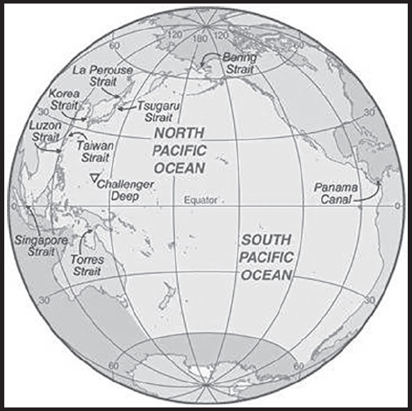
Background: The Pacific Ocean is the largest of the world’s five oceans (followed by the Atlantic Ocean, Indian Ocean, Southern Ocean, and Arctic Ocean). Strategically important access waterways include the La Perouse, Tsugaru, Tsushima, Taiwan, Singapore, and Torres Straits. The decision by the International Hydrographic Organization in the spring of 2000 to delimit a fifth ocean, the Southern Ocean, removed the portion of the Pacific Ocean south of 60 degrees south. For convenience and because of its immense size, the Pacific Ocean is often divided at the Equator and designated as the North Pacific Ocean and the South Pacific Ocean.
GEOGRAPHY
Location: body of water between the Southern Ocean, Asia, Australia, and the Western Hemisphere
Geographic coordinates: 0 00 N, 160 00 W
Map references: Political Map of the World
Area: total: 168.723 million sq km
note: includes Arafura Sea, Bali Sea, Banda Sea, Bering Sea, Bering Strait, Celebes Sea, Coral Sea, East China Sea, Flores Sea, Gulf of Alaska, Gulf of Thailand, Gulf of Tonkin, Java Sea, Philippine Sea, Sea of Japan, Sea of Okhotsk, Solomon Sea, South China Sea, Sulu Sea, Tasman Sea, and other tributary water bodies
Area - comparative: about 15 times the size of the US; covers about 28% of the global surface; almost equal to the total land area of the world
Coastline: 135,663 km
Climate: planetary air pressure systems and resultant wind patterns exhibit remarkable uniformity in the south and east; trade winds and westerly winds are well-developed patterns, modified by seasonal fluctuations; tropical cyclones (hurricanes) may form south of Mexico from June to October and affect Mexico and Central America; continental influences cause climatic uniformity to be much less pronounced in the eastern and western regions at the same latitude in the North Pacific Ocean; the western Pacific is monsoonal - a rainy season occurs during the summer months, when moisture- laden winds blow from the ocean over the land, and a dry season during the winter months, when dry winds blow from the Asian landmass back to the ocean; tropical cyclones (typhoons) may strike southeast and east Asia from May to December
Ocean volume: ocean volume: 669.88 million cu km
percent of World Ocean total volume: 50.1%
Major ocean currents: the clockwise North Pacific Gyre formed by the warm northward flowing Kuroshio Current in the west, the eastward flowing North Pacific Current in the north, the southward flowing cold California Current in the east, and the westward flowing North Equatorial Current in the south; the counterclockwise South Pacific Gyre composed of the southward flowing warm East Australian Current in the west, the eastward flowing South Pacific Current in the south, the northward flowing cold Peru (Humbolt) Current in the east, and the westward flowing South Equatorial Current in the north
Elevation: highest point: sea level
lowest point: Challenger Deep in the Mariana Trench -10,924 m
note - the Pacific Ocean is the deepest ocean basin
mean depth: -4,080 m
ocean zones: Composed of water and in a fluid state, the oceans are delimited differently than the solid continents. Oceans are divided into three zones based on depth and light level. Although some sea creatures depend on light to live, others can do without it. Sunlight entering the water may travel about 1,000 m into the oceans under the right conditions, but there is rarely any significant light beyond 200 m.
The upper 200 m (656 ft) of oceans is called the euphotic, or “sunlight,” zone. This zone contains the vast majority of commercial fisheries and is home to many protected marine mammals and sea turtles. Only a small amount of light penetrates beyond this depth.
The zone between 200 m (656 ft) and 1,000 m (3,280 ft) is usually referred to as the “twilight” zone, but is officially the dysphotic zone. In this zone, the intensity of light rapidly dissipates as depth increases. Such a minuscule amount of light penetrates beyond a depth of 200 m that photosynthesis is no longer possible.
The aphotic, or “midnight,” zone exists in depths below 1,000 m (3,280 ft). Sunlight does not penetrate to these depths and the zone is bathed in darkness.
Natural resources: oil and gas fields, polymetallic nodules, sand and gravel aggregates, placer deposits, fish
Natural hazards: surrounded by a zone of violent volcanic and earthquake activity sometimes referred to as the “Pacific Ring of Fire”; up to 90% of the world’s earthquakes and some 75% of the world’s volcanoes occur within the Ring of Fire; 80% of tsunamis, caused by volcanic or seismic events, occur within the “Pacific Ring of Fire”; subject to tropical cyclones (typhoons) in southeast and east Asia from May to December (most frequent from July to October); tropical cyclones (hurricanes) may form south of Mexico and strike Central America and Mexico from June to October (most common in August and September); cyclical El Nino/La Nina phenomenon occurs in the equatorial Pacific, influencing weather in the Western Hemisphere and the western Pacific; ships subject to superstructure icing in extreme north from October to May; persistent fog in the northern Pacific can be a maritime hazard from June to December
Geography - note: the major chokepoints are the Bering Strait, Panama Canal, Luzon Strait, and the Singapore Strait; the Equator divides the Pacific Ocean into the North Pacific Ocean and the South Pacific Ocean; dotted with low coral islands and rugged volcanic islands in the southwestern Pacific Ocean; much of the Pacific Ocean’s rim lies along the Ring of Fire, a belt of active volcanoes and earthquake epicenters that accounts for up to 90% of the world’s earthquakes and some 75% of the world’s volcanoes; the Pacific Ocean is the deepest ocean basin averaging 4,000 m in depth
PEOPLE AND SOCIETY
Contraceptive prevalence rate: NA
ENVIRONMENT
Environment - current issues: pollution (such as sewage, runoff from land and toxic waste); habitat destruction; over-fishing; climate change leading to sea level rise, ocean acidification, and warming; endangered marine species include the dugong, sea lion, sea otter, seals, turtles, and whales; oil pollution in Philippine Sea and South China Sea
Climate: planetary air pressure systems and resultant wind patterns exhibit remarkable uniformity in the south and east; trade winds and westerly winds are well-developed patterns, modified by seasonal fluctuations; tropical cyclones (hurricanes) may form south of Mexico from June to October and affect Mexico and Central America; continental influences cause climatic uniformity to be much less pronounced in the eastern and western regions at the same latitude in the North Pacific Ocean; the western Pacific is monsoonal - a rainy season occurs during the summer months, when moisture-laden winds blow from the ocean over the land, and a dry season during the winter months, when dry winds blow from the Asian landmass back to the ocean; tropical cyclones (typhoons) may strike southeast and east Asia from May to December
Marine fisheries: the Pacific Ocean fisheries are the most important in the world accounting for 58.1%, or 45,800,000 mt, of the global marine capture in 2020; of the six regions delineated by the Food and Agriculture Organization in the Pacific Ocean, the following are the most important:
Northwest Pacific region (Region 61) is the world’s most important fishery producing 24.3% of the global catch or 19,150,000 mt in 2020; it encompasses the waters north of 20° north latitude and west of 175° west longitude with the major producers including China (29,080726 mt), Japan (3,417,871 mt), South Korea (1,403,892 mt), and Taiwan (487,739 mt); the principal catches include Alaska Pollock, Japanese anchovy, chub mackerel, and scads
Western Central Pacific region (Region 71) is the world’s second most important fishing region producing 16.8%, or 13,260,000 mt, of the global catch in 2020; tuna is the most important species in this region; the region includes the waters between 20° North and 25° South latitude and west of 175° West longitude with the major producers including Indonesia (6,907,932 mt), Vietnam (4,571,497 mt), Philippines (2,416,879 mt), Thailand (1,509,574 mt), and Malaysia (692,553 mt); the principal catches include Skipjack and Yellowfin tuna, sardinellas, and cephalopods
Southeast Pacific region (Region 87) is the third major Pacific fishery and third largest in the world producing 10.7%, or 8,400,000 mt, of the global catch in 2020; this region includes the nutrient rich upwelling waters off the west coast of South America between 5° North and 60° South latitude and east of 120° West longitude with the major producers including Peru (4,888,730 mt), Chile (3,298,795 mt), and Ecuador (1,186,249 mt); the principal catches include Peruvian anchovy (68.5% of the catch), Jumbo flying squid, and Chilean jack mackerel
Pacific Northeast region (Region 67) is the fourth largest Pacific Ocean fishery and eighth largest in the world producing 3.6% of the global catch or 2,860,000 mt in 2020; this region encompasses the waters north of 40° North latitude and east of 175° West longitude including the Gulf of Alaska and Bering Sea with the major producers including the US (3,009,568 mt), Canada (276,677 mt), and Russia (6,908 mt); the principal catches include Alaska pollock, Pacific cod, and North Pacific hake
Regional fisheries bodies: Commission for the Conservation of Southern Bluefin Tuna, Inter-American Tropical Tuna Commission, International Council for the Exploration of the Seas, North Pacific Anadromous Fish Commission, North Pacific Fisheries Commission, South Pacific Regional Fisheries Management Organization, Southeast Asian Fisheries Development Center, Western and Central Pacific Fisheries Commission
GOVERNMENT
Country name: etymology: named by Portuguese explorer Ferdinand MAGELLAN during the Spanish circumnavigation of the world in 1521; encountering favorable winds upon reaching the ocean, he called it “Mar Pacifico,” which means “peaceful sea” in both Portuguese and Spanish
TRANSPORTATION
Icebreakers: North Pacific
China: one PC 3 or 4 class medium icebreaker, and three PC 5 or 6 class light icebreakers
Japan: one PC 3 or 4 class medium icebreaker
Russia: one PC 3 or 4 class medium icebreaker, and six PC 5 or 6 class light icebreakers
US: one PC 1 or 2 class heavy icebreaker, one PC 3 or 4 class medium icebreaker, and one PC 5 or 6 class light icebreaker
South Pacific
Australia: one PC 3 or 4 class medium icebreaker
Chile: one PC 5 or 6 class light icebreaker
France (French Polynesia): one PC 3 or 4 class medium icebreaker
note: the ships are listed by Polar Class (PC) vessel: PC 1 - year-round operation in all polar waters (ice thickness >3 m); PC 2 - year-round operation in moderate multi-year ice conditions (ice thickness up to 3 m); PC 3 - year-round operation in second-year ice which may include multi-year ice inclusions (ice thickness up to 2.5 m); PC 4 - year-round operation in thick first-year ice which may include old ice inclusions (ice thickness up to 120 cm); PC 5 - year-round operation in medium first-year ice which may include old ice inclusions (ice thickness up to 70-120 cm); PC 6 - summer/autumn operation in medium first-year ice which may include old ice inclusions (ice thickness up to 30-70 cm)
Ports and terminals: major seaport(s): Bangkok (Thailand), Hong Kong (China), Kao-hsiung (Taiwan), Los Angeles (US), Manila (Philippines), Pusan (South Korea), San Francisco (US), Seattle (US), Shanghai (China), Singapore, Sydney (Australia), Vladivostok (Russia), Wellington (NZ), Yokohama (Japan)
MILITARY AND SECURITY
Military - note: according to the International Maritime Bureau, the risk for piracy and armed robbery in the territorial waters of littoral states and offshore waters in the South China Sea is high, particularly the Singapore Straits and the Celebes and Sulu Seas between the Philippines and Malaysia (2023)
TRANSNATIONAL ISSUES
Disputes - international: some maritime disputes (see littoral states)
PAKISTAN
INTRODUCTION
Background: The Indus Valley civilization, one of the oldest in the world and dating back at least 5,000 years, spread over much of what is presently Pakistan. During the second millennium B.C., remnants of this culture fused with the migrating Indo-Aryan peoples. The area underwent successive invasions in subsequent centuries from the Persians, Greeks, Scythians, Arabs (who brought Islam), Afghans, and Turks. The Mughal Empire flourished in the 16th and 17th centuries; the British came to dominate the region in the 18th century. The separation in 1947 of British India into the Muslim state of Pakistan (with West and East sections) and largely Hindu India created lasting tension between the two countries, and India and Pakistan fought two wars and a limited conflict - in 1947-48, 1965, and 1999 respectively - over the disputed Kashmir territory. A third war between these countries in 1971 - in which India assisted an indigenous movement reacting to the marginalization of Bengalis in Pakistani politics - resulted in East Pakistan becoming the separate nation of Bangladesh.
In response to Indian nuclear weapons testing, Pakistan conducted its own tests in mid-1998. Major bilateral disputes, including the status of Kashmir, remain unresolved, but in early 2021 the two countries reaffirmed their commitment to maintain the cease-fire along the Line of Control in Kashmir that began in 2003. Pakistan has been engaged in a decades-long armed conflict with militant groups, including the Tehreek-e-Taliban Pakistan (TTP) and other militant networks, that target government institutions and civilians.
GEOGRAPHY
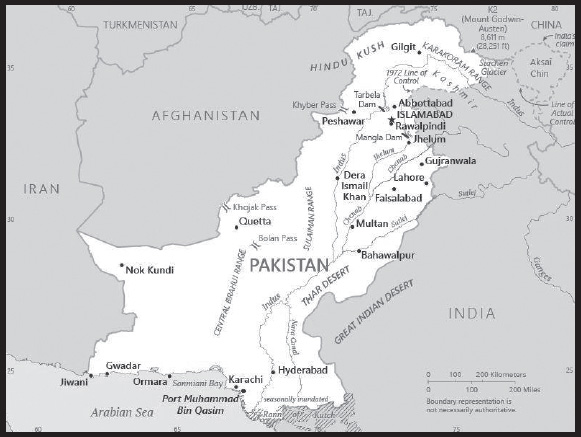
Location: Southern Asia, bordering the Arabian Sea, between India on the east and Iran and Afghanistan on the west and China in the north
Geographic coordinates: 30 00 N, 70 00 E
Map references: Asia
Area: total: 796,095 sq km
land: 770,875 sq km
water: 25,220 sq km
comparison ranking: total 37
Area - comparative: slightly more than five times the size of Georgia; slightly less than twice the size of California
Land boundaries: total: 7,257 km
border countries (4): Afghanistan 2,670 km; China 438 km; India 3,190 km; Iran 959 km
Coastline: 1,046 km
Maritime claims: territorial sea: 12 nm
contiguous zone: 24 nm
exclusive economic zone: 200 nm
continental shelf: 200 nm or to the edge of the continental margin
Climate: mostly hot, dry desert; temperate in northwest; arctic in north
Terrain: divided into three major geographic areas: the northern highlands, the Indus River plain in the center and east, and the Balochistan Plateau in the south and west
Elevation: highest point: K2 (Mt. Godwin-Austen) 8,611 m
lowest point: Arabian Sea 0 m
mean elevation: 900 m
Natural resources: arable land, extensive natural gas reserves, limited petroleum, poor quality coal, iron ore, copper, salt, limestone
Land use: agricultural land: 35.2% (2018 est.)
arable land: 27.6% (2018 est.)
permanent crops: 1.1% (2018 est.)
permanent pasture: 6.5% (2018 est.)
forest: 2.1% (2018 est.)
other: 62.7% (2018 est.)
Irrigated land: 193,400 sq km (2020)
Major rivers (by length in km): Indus river mouth (shared with China [s] and India) - 3,610 km; Sutlej river mouth (shared with China [s] and India) - 1,372 km; Chenab river mouth (shared with India [s]) - 1,086 km
note – [s] after country name indicates river source; [m] after country name indicates river mouth
Major watersheds (area sq km): Indian Ocean drainage: Indus (1,081,718 sq km)
Internal (endorheic basin) drainage: Tarim Basin (1,152,448 sq km), (Aral Sea basin) Amu Darya (534,739 sq km)
Major aquifers: Indus Basin
Population distribution: the Indus River and its tributaries attract most of the settlement, with Punjab province the most densely populated
Natural hazards: frequent earthquakes, occasionally severe especially in north and west; flooding along the Indus after heavy rains (July and August)
Geography - note: controls Khyber Pass and Bolan Pass, traditional invasion routes between Central Asia and the Indian Subcontinent
PEOPLE AND SOCIETY
Population: 247,653,551 (2023 est.)
note: results of Pakistan’s 2017 national census estimate the country’s total population to be 207,684,626
comparison ranking: 5
Nationality: noun: Pakistani(s)
adjective: Pakistani
Ethnic groups: Punjabi 44.7%, Pashtun (Pathan) 15.4%, Sindhi 14.1%, Saraiki 8.4%, Muhajirs 7.6%, Balochi 3.6%, other 6.3%
Languages: Punjabi 38.8%, Pashto (alternate name, Pashtu) 18.2%, Sindhi 14.6%, Saraiki (a Punjabi variant) 12.2%, Urdu 7.1%, Balochi 3%, Hindko 2.4%, Brahui 1.2%, other 2.4%
major-language sample(s):

note: data represent population by mother tongue; English (official; lingua franca of Pakistani elite and most government ministries)
Religions: Muslim (official) 96.5% (Sunni 85-90%, Shia 10-15%), other (includes Christian and Hindu) 3.5% (2020 est.)
Age structure: 0-14 years: 34.81% (male 44,002,871/female 42,216,200)
15-64 years: 60.41% (male 76,548,821/female 73,065,518)
65 years and over: 4.77% (2023 est.) (male 5,482,633/female 6,337,508)
Dependency ratios: total dependency ratio: 70
youth dependency ratio: 62.8
elderly dependency ratio: 7.2
potential support ratio: 13.9 (2021 est.)
Median age: total: 22 years (2020)
male: 21.9 years
female: 22.1 years
comparison ranking: total 180
Population growth rate: 1.91% (2023 est.)
comparison ranking: 44
Birth rate: 26.01 births/1,000 population (2023 est.)
comparison ranking: 41
Death rate: 5.94 deaths/1,000 population (2023 est.)
comparison ranking: 159
Net migration rate: -1.01 migrant(s)/1,000 population (2023 est.)
comparison ranking: 148
Population distribution: the Indus River and its tributaries attract most of the settlement, with Punjab province the most densely populated
Urbanization: urban population: 38% of total population (2023)
rate of urbanization: 2.1% annual rate of change (2020-25 est.)
Major urban areas - population: 17.236 million Karachi, 13.979 million Lahore, 3.711 million Faisalabad, 2.415 million Gujranwala, 2.412 million Peshawar, 1.232 million ISLAMABAD (capital) (2023)
Sex ratio: at birth: 1.05 male(s)/female
0-14 years: 1.04 male(s)/female
15-64 years: 1.05 male(s)/female
65 years and over: 0.87 male(s)/female
total population: 1.04 male(s)/female (2023 est.)
Mother’s mean age at first birth: 22.8 years (2017/18 est.)
note: data represents median age at first birth among women 25-49
Maternal mortality ratio: 154 deaths/100,000 live births (2020 est.)
comparison ranking: 54
Infant mortality rate: total: 52.73 deaths/1,000 live births (2023 est.)
male: 57.13 deaths/1,000 live births
female: 48.1 deaths/1,000 live births
comparison ranking: total 17
Life expectancy at birth: total population: 69.96 years (2023 est.)
male: 67.89 years
female: 72.14 years
comparison ranking: total population 176
Total fertility rate: 3.39 children born/woman (2023 est.)
comparison ranking: 39
Gross reproduction rate: 1.66 (2023 est.)
Contraceptive prevalence rate: 34% (2018/19)
Drinking water source: improved: urban: 96.5% of population
rural: 92.5% of population
total: 94% of population
unimproved: urban: 3.5% of population
rural: 7.5% of population
total: 6% of population (2020 est.)
Current health expenditure: 2.8% of GDP (2020)
Physicians density: 1.12 physicians/1,000 population (2019)
Hospital bed density: 0.6 beds/1,000 population (2017)
Sanitation facility access: improved: urban: 88.6% of population
rural: 73.2% of population
total: 78.9% of population
unimproved: urban: 11.4% of population
rural: 26.8% of population
total: 21.1% of population (2020 est.)
Major infectious diseases: degree of risk: high (2023)
food or waterborne diseases: bacterial diarrhea, hepatitis A and E, and typhoid fever
vectorborne diseases: dengue fever, malaria, and Crimean-Congo hemorrhagic fever
animal contact diseases: rabies
note: Pakistan is one of two countries with endemic wild polio virus (the other is Afghanistan) and considered high risk for international spread of the disease; before any international travel, anyone unvaccinated, incompletely vaccinated, or with an unknown polio vaccination status should complete the routine polio vaccine series; before travel to any high-risk destination, the US Centers for Disease Control and Prevention (CDC) recommends that adults who previously completed the full, routine polio vaccine series receive a single, lifetime booster dose of polio vaccine
Obesity - adult prevalence rate: 8.6% (2016)
comparison ranking: 148
Alcohol consumption per capita: total: 0.04 liters of pure alcohol (2019 est.)
beer: 0 liters of pure alcohol (2019 est.)
wine: 0 liters of pure alcohol (2019 est.)
spirits: 0.04 liters of pure alcohol (2019 est.)
other alcohols: 0 liters of pure alcohol (2019 est.)
comparison ranking: total 180
Tobacco use: total: 20.2% (2020 est.)
male: 33% (2020 est.)
female: 7.3% (2020 est.)
comparison ranking: total 86
Children under the age of 5 years underweight: 23.1% (2017/18)
comparison ranking: 8
Currently married women (ages 15-49): 63.5% (2023 est.)
Child marriage: women married by age 15: 3.6%
women married by age 18: 18.3%
men married by age 18: 4.7% (2018 est.)
Education expenditures: 2.4% of GDP (2021 est.)
comparison ranking: 177
Literacy: definition: age 15 and over can read and write
total population: 58%
male: 69.3%
female: 46.5% (2019)
School life expectancy (primary to tertiary education): total: 9 years
male: 9 years
female: 8 years (2019)
Youth unemployment rate (ages 15-24): total: 9.4% (2021 est.)
male: 9.7%
female: 8.2%
comparison ranking: total 161
ENVIRONMENT
Environment - current issues: water pollution from raw sewage, industrial wastes, and agricultural runoff; limited natural freshwater resources; most of the population does not have access to potable water; deforestation; soil erosion; desertification; air pollution and noise pollution in urban areas
Environment - international agreements: party to: Antarctic-Environmental Protection, Antarctic-Marine Living Resources, Antarctic Treaty, Biodiversity, Climate Change, Climate Change-Kyoto Protocol, Climate Change-Paris Agreement, Desertification, Endangered Species, Environmental Modification, Hazardous Wastes, Law of the Sea, Marine Dumping-London Convention, Nuclear Test Ban, Ozone Layer Protection, Ship Pollution, Wetlands
signed, but not ratified: Marine Life Conservation
Climate: mostly hot, dry desert; temperate in northwest; arctic in north
Land use: agricultural land: 35.2% (2018 est.)
arable land: 27.6% (2018 est.)
permanent crops: 1.1% (2018 est.)
permanent pasture: 6.5% (2018 est.)
forest: 2.1% (2018 est.)
other: 62.7% (2018 est.)
Urbanization: urban population: 38% of total population (2023)
rate of urbanization: 2.1% annual rate of change (2020-25 est.)
Food insecurity: severe localized food insecurity: due to population displacements, economic constraints, and high prices of the main food staple - according to the latest analysis, about 4.7 million people, 25% of the population, are estimated to be facing high levels of acute food insecurity, between April and June 2022 in 25 districts analyzed in Balochistan, Sindh and Khyber Pakhtunkhwa provinces; prices of wheat flour, the country’s main staple, were at high levels in most markets in May 2022, constraining access to the staple food (2022)
Revenue from forest resources: 0.1% of GDP (2018 est.)
comparison ranking: 114
Revenue from coal: 0.06% of GDP (2018 est.)
comparison ranking: 29
Air pollutants: particulate matter emissions: 50.13 micrograms per cubic meter (2019 est.)
carbon dioxide emissions: 201.15 megatons (2016 est.)
methane emissions: 142.12 megatons (2020 est.)
Waste and recycling: municipal solid waste generated annually: 30.76 million tons (2017 est.)
municipal solid waste recycled annually: 2,460,800 tons (2017 est.)
percent of municipal solid waste recycled: 8% (2017 est.)
Major rivers (by length in km): Indus river mouth (shared with China [s] and India) - 3,610 km; Sutlej river mouth (shared with China [s] and India) - 1,372 km; Chenab river mouth (shared with India [s]) - 1,086 km
note – [s] after country name indicates river source; [m] after country name indicates river mouth
Major watersheds (area sq km): Indian Ocean drainage: Indus (1,081,718 sq km)
Internal (endorheic basin) drainage: Tarim Basin (1,152,448 sq km), (Aral Sea basin) Amu Darya (534,739 sq km)
Major aquifers: Indus Basin
Total water withdrawal: municipal: 9.65 billion cubic meters (2020 est.)
industrial: 1.4 billion cubic meters (2020 est.)
agricultural: 172.4 billion cubic meters (2020 est.)
Total renewable water resources: 246.8 billion cubic meters (2020 est.)
GOVERNMENT
Country name: conventional long form: Islamic Republic of Pakistan
conventional short form: Pakistan
local long form: Jamhuryat Islami Pakistan
local short form: Pakistan
former: West Pakistan
etymology: the word “pak” means “pure” in Persian or Pashto, while the Persian suffix “-stan” means “place of” or “country,” so the word Pakistan literally means “Land of the Pure”
Government type: federal parliamentary republic
Capital: name: Islamabad
geographic coordinates: 33 41 N, 73 03 E
time difference: UTC+5 (10 hours ahead of Washington, DC, during Standard Time)
etymology: derived from two words: Islam, an Urdu word referring to the religion of Islam, and -abad, a Persian suffix indicating an “inhabited place” or “city,” to render the meaning “City of Islam”
Administrative divisions: 4 provinces, 2 Pakistan-administered areas*, and 1 capital territory**; Azad Kashmir*, Balochistan, Gilgit-Baltistan*, Islamabad Capital Territory**, Khyber Pakhtunkhwa, Punjab, Sindh
Independence: 14 August 1947 (from British India)
National holiday: Pakistan Day (also referred to as Pakistan Resolution Day or Republic Day), 23 March (1940); note - commemorates both the adoption of the Lahore Resolution by the All-India Muslim League during its 22-24 March 1940 session, which called for the creation of independent Muslim states, and the adoption of the first constitution of Pakistan on 23 March 1956 during the transition to the Islamic Republic of Pakistan
Constitution: history: several previous; latest endorsed 12 April 1973, passed 19 April 1973, entered into force 14 August 1973 (suspended and restored several times)
amendments: proposed by the Senate or by the National Assembly; passage requires at least two-thirds majority vote of both houses; amended many times, last in 2018
Legal system: common law system with Islamic law influence
International law organization participation: accepts compulsory ICJ jurisdiction with reservations; non-party state to the ICCt
Citizenship: citizenship by birth: yes
citizenship by descent only: at least one parent must be a citizen of Pakistan
dual citizenship recognized: yes, but limited to select countries
residency requirement for naturalization: 4 out of the previous 7 years and including the 12 months preceding application
Suffrage: 18 years of age; universal; note - there are joint electorates and reserved parliamentary seats for women and non-Muslims
Executive branch: chief of state: President Arif ALVI (since 9 September 2018)
head of government: Interim Prime Minister Anwaar-ul-Haq KAKAR (since 14 August 2023); caretaker cabinet (since 17 August 2023)
cabinet: Cabinet appointed by the president upon the advice of the prime minister
elections/appointments: president indirectly elected by the Electoral College consisting of members of the Senate, National Assembly, and provincial assemblies for a 5-year term (limited to 2 consecutive terms); election last held on 4 September 2018 (next expected to be held in early 2024); prime minister elected by the National Assembly on 11 April 2022
election results:
2018: Arif ALVI elected president; Electoral College vote - Arif ALVI (PTI) 352, Fazl-ur-REHMAN (MMA) 184, Aitzaz AHSAN (PPP) 124; Imran KHAN elected prime minister; National Assembly vote - Imran KHAN (PTI) 176, Shehbaz SHARIF (PML-N) 96
2013: Mamnoon HUSSAIN elected president; National Assembly vote - Mamnoon HUSSAIN (PML-N) 432, Wajihuddin AHMED (PTI) 77
Legislative branch: description: bicameral Parliament or Majlis-e-Shoora consists of:
Senate (100 seats; members indirectly elected by the 4 provincial assemblies and the federal capital territory indirectly elected by the National Assembly using proportional representation vote; members serve 6-year terms with one-half of the membership renewed every 3 years)
National Assembly (342 seats; 272 members directly elected in single-seat constituencies by simple majority vote and 70 members - 60 women and 10 non-Muslims - directly elected by proportional representation vote; all members serve 5-year terms)
elections:
Senate - last held on 3 March 2021 (next to be held on 3 March 2024)
National Assembly - last held on 25 July 2018 (next rescheduled from October 2023 to 31 January 2024 to 4 February 2024 due to the redrawing of many electoral district boundaries)
election results:
Senate - percent of vote by party - NA; seats by party - PTI 25, PPP 21, PML-N 18, BAP 13, JUI-F 5, other 13, independent 5; composition - men 81, women 19, percent of women 19%
National Assembly - percent of votes by party - NA; seats by party - PTI 156, PML-N 83, PPP 55, MMA 16, MQM-P 7, BAP 5, PML-Q 5, BNP-M 4, GDA 3, AML 1, ANP 1, JWP 1, independent 4; composition - men 272, women 70, percent of women 20.2%; note - total Parliament percent of women 20.1%
Judicial branch: highest court(s): Supreme Court of Pakistan (consists of the chief justice and 16 judges)
judge selection and term of office: justices nominated by an 8-member parliamentary committee upon the recommendation of the Judicial Commission, a 9-member body of judges and other judicial professionals, and appointed by the president; justices can serve until age 65
subordinate courts: High Courts; Federal Shariat Court; provincial and district civil and criminal courts; specialized courts for issues, such as taxation, banking, and customs
Political parties and leaders: Awami National Party or ANP [Asfandyar Wali KHAN]
Awami Muslim League or AML [Sheikh Rashid AHMED]
Balochistan Awami Party or BAP [Abdul Quddus BIZENJO]
Balochistan National Party-Awami or BNP-A [Mir Israrullah ZEHRI]
Balochistan National Party-Mengal or BNP-M [Sardar Akhtar Jan MENGAL]
Grand Democratic Alliance or GDA [Pir PAGARO] (alliance of several parties)
Hazara Democratic Party or HDP [Abdul Khaliq HAZARA]
Jamaat-e-Islami or JI [Siraj-ul-HAQ]
Jamhoori Wattan Party or JWP [Nawabzada Shahzain BUGTI]
Jamiat Ulema-e-Islam-Fazl or JUI-F [Maulana Fazal-ur-REHMAN]
Muttahida Majlis-e-Amal or MMA [Maulana Fazal-ur-REHMAN] (alliance of several parties)
Muttahida Qaumi Movement-Pakistan or MQM-P [Khalid Maqbool SIDDIQUI]
National Party or NP [Abdul Malik BALOCH]
Pashtoonkhwa Milli Awami Party or PMAP or PKMAP [Mahmood Khan ACHAKZAI]
Pakistan Muslim League-Nawaz or PML-N [Shehbaz SHARIF]
Pakistan Muslim League-Quaid-e-Azam or PML-Q [Chaudhry Shujaat HUSSAIN]
Pakistan Muslim League-Functional or PML-F [Pir PAGARO]
Pakistan Peoples Party or PPP [Bilawal BHUTTO ZARDARI, Asif Ali ZARDARI]
Pakistan Rah-e-Haq Party or PRHP [Muhammad Ibrahim QASMI]
Pakistan Tehrik-e Insaaf or PTI (Pakistan Movement for Justice) [Imran KHAN]
Tehreek-e-Labbaik Pakistan or TLP [Hafiz Muhammad Saad Hussain Rizvi MARKAZI]
note: Pakistan has several hundred officially registered political parties; this list includes those that won seats in the most recent elections at the national and provincial levels
International organization participation: ADB, AIIB, ARF, ASEAN (sectoral dialogue partner), C, CERN (associate member), CICA, CP, D-8, ECO, FAO, G-11, G-24, G-77, IAEA, IBRD, ICAO, ICC (national committees), ICRM, IDA, IDB, IFAD, IFC, IFRCS, IHO, ILO, IMF, IMO, IMSO, Interpol, IOC, IOM, IPU, ISO, ITSO, ITU, ITUC (NGOs), MIGA, MINURCAT, MINURSO, MINUSCA, MINUSMA, MONUSCO, NAM, OAS (observer), OIC, OPCW, PCA, SAARC, SACEP, SCO, UN, UNAMID, UNCTAD, UNESCO, UNFICYP, UNHCR, UNHRC, UNIDO, UNISFA, UNISFA, UNMISS, UNOOSA, UNSOS, UNWTO, UPU, WCO, WFTU (NGOs), WHO, WIPO, WMO, WTO
Diplomatic representation in the US: chief of mission: Ambassador Sardar Masood KHAN (since 19 April 2022)
chancery: 3517 International Court NW, Washington, DC 20008
telephone: [1] (202) 243-6500
FAX: [1] (202) 686-1534
email address and website:
consularsection@embassyofpakistanusa.org
https://embassyofpakistanusa.org/
consulate(s) general: Chicago, Houston, Los Angeles, New York
Diplomatic representation from the US: chief of mission: Ambassador Donald BLOME (since 2 July 2022)
embassy: Diplomatic Enclave, Ramna 5, Islamabad
mailing address: 8100 Islamabad Place, Washington, DC 20521-8100
telephone: [92] 051-201-4000
FAX: [92] 51-2338071
email address and website:
consulate(s) general: Karachi, Lahore, Peshawar
Flag description: green with a vertical white band (symbolizing the role of religious minorities) on the hoist side; a large white crescent and star are centered in the green field; the crescent, star, and color green are traditional symbols of Islam
National symbol(s): five-pointed star between the horns of a waxing crescent moon, jasmine; national colors: green, white
National anthem: name: “Qaumi Tarana” (National Anthem)
lyrics/music: Abu-Al-Asar Hafeez JULLANDHURI/Ahmed Ghulamali CHAGLA
note: adopted 1954; also known as “Pak sarzamin shad bad” (Blessed Be the Sacred Land)
National heritage: total World Heritage Sites: 6 (all cultural)
selected World Heritage Site locales: Archaeological Ruins at Moenjodaro; Buddhist Ruins of Takht-i-Bahi; Taxila; Fort and Shalamar Gardens in Lahore; Historical Monuments at Makli, Thatta; Rohtas Fort
ECONOMY
Economic overview: lower middle-income South Asian economy; extremely high debt; endemic corruption; major currency devaluation; major food insecurity and inflation; environmentally fragile agricultural sector; regional disputes with India and Afghanistan hinder investment
Real GDP (purchasing power parity): $1.211 trillion (2021 est.)
$1.137 trillion (2020 est.)
$1.152 trillion (2019 est.)
note: data are in 2017 dollars data are for fiscal years
comparison ranking: 23
Real GDP growth rate: 6.49% (2021 est.)
-1.27% (2020 est.)
2.5% (2019 est.)
note: data are for fiscal years
comparison ranking: 66
Real GDP per capita: $5,200 (2021 est.)
$5,000 (2020 est.)
$5,200 (2019 est.)
note: data are in 2017 dollars
comparison ranking: 175
GDP (official exchange rate): $253.183 billion (2019 est.)
Inflation rate (consumer prices): 9.5% (2021 est.)
9.74% (2020 est.)
10.58% (2019 est.)
comparison ranking: 26
Credit ratings:
Fitch rating: B- (2018)
Moody’s rating: B3 (2015)
Standard & Poors rating: B- (2019)
note: The year refers to the year in which the current credit rating was first obtained.
GDP - composition, by sector of origin: agriculture: 24.4% (2016 est.)
industry: 19.1% (2016 est.)
services: 56.5% (2017 est.)
comparison rankings: services 147; industry 157; agriculture 30
GDP - composition, by end use: household consumption: 82% (2017 est.)
government consumption: 11.3% (2017 est.)
investment in fixed capital: 14.5% (2017 est.)
investment in inventories: 1.6% (2017 est.)
exports of goods and services: 8.2% (2017 est.)
imports of goods and services: -17.6% (2017 est.)
Agricultural products: sugar cane, buffalo milk, wheat, milk, rice, maize, potatoes, cotton, fruit, mangoes/guavas
Industries: textiles and apparel, food processing, pharmaceuticals, surgical instruments, construction materials, paper products, fertilizer, shrimp
Industrial production growth rate: 7.81% (2021 est.)
comparison ranking: 53
Labor force: 73.133 million (2021 est.)
note: extensive export of labor, mostly to the Middle East, and use of child labor
comparison ranking: 6
Labor force - by occupation: agriculture: 42.3%
industry: 22.6%
services: 35.1% (FY2015 est.)
Unemployment rate: 4.35% (2021 est.)
4.3% (2020 est.)
3.54% (2019 est.)
note: Pakistan has substantial underemployment
comparison ranking: 168
Youth unemployment rate (ages 15-24): total: 9.4% (2021 est.)
male: 9.7%
female: 8.2%
comparison ranking: total 161
Population below poverty line: 24.3% (2015 est.)
Gini Index coefficient - distribution of family income: 29.6 (2018 est.)
comparison ranking: 150
Average household expenditures: on food: 39.5% of household expenditures (2018 est.)
on alcohol and tobacco: 1.1% of household expenditures (2018 est.)
Household income or consumption by percentage share: lowest 10%: 4%
highest 10%: 26.1% (FY2013)
Budget: revenues: $38.966 billion (2020 est.)
expenditures: $59.621 billion (2020 est.)
note: data are for fiscal years
Budget surplus (+) or deficit (-): -5.8% (of GDP) (2017 est.)
comparison ranking: 180
Public debt: 67% of GDP (2017 est.)
67.6% of GDP (2016 est.)
comparison ranking: 65
Taxes and other revenues: 15.4% (of GDP) (2017 est.)
comparison ranking: 141
Fiscal year: 1 July - 30 June
Current account balance: -$12.262 billion (2021 est.)
-$650.874 million (2020 est.)
-$8.558 billion (2019 est.)
comparison ranking: 196
Exports: $35.566 billion (2021 est.) note: data are in current year dollars
$27.333 billion (2020 est.) note: data are in current year dollars
$30.67 billion (2019 est.) note: data are in current year dollars
comparison ranking: 69
Exports - partners: United States 14%, China 8%, Germany 7%, United Kingdom 6% (2019)
Exports - commodities: textiles, clothing and apparel, rice, leather goods, surgical instruments (2019)
Imports: $76.392 billion (2021 est.) note: data are in current year dollars
$52.098 billion (2020 est.) note: data are in current year dollars
$57.976 billion (2019 est.) note: data are in current year dollars
comparison ranking: 51
Imports - partners: China 28%, United Arab Emirates 11%, United States 5% (2019)
Imports - commodities: refined petroleum, crude petroleum, natural gas, palm oil, scrap iron (2019)
Reserves of foreign exchange and gold: $22.812 billion (31 December 2021 est.)
$18.522 billion (31 December 2020 est.)
$16.586 billion (31 December 2019 est.)
comparison ranking: 64
Debt - external: $107.527 billion (2019 est.)
$95.671 billion (2018 est.)
comparison ranking: 54
Exchange rates: Pakistani rupees (PKR) per US dollar -
Exchange rates:
162.906 (2021 est.)
161.838 (2020 est.)
150.036 (2019 est.)
121.824 (2018 est.)
105.455 (2017 est.)
ENERGY
Electricity access: population without electricity: 46 million (2020)
electrification - total population: 94.9% (2021)
electrification - urban areas: 99.9% (2021)
electrification - rural areas: 91.9% (2021)
Electricity: installed generating capacity: 39.925 million kW (2020 est.)
consumption: 103,493,520,000 kWh (2019 est.)
exports: 0 kWh (2019 est.)
imports: 487 million kWh (2019 est.)
transmission/distribution losses: 17.389 billion kWh (2019 est.)
comparison rankings: installed generating capacity 30; transmission/distribution losses 24; imports 88; exports 178; consumption 33
Electricity generation sources: fossil fuels: 55.2% of total installed capacity (2020 est.)
nuclear: 8.2% of total installed capacity (2020 est.)
solar: 1% of total installed capacity (2020 est.)
wind: 2.8% of total installed capacity (2020 est.)
hydroelectricity: 31.9% of total installed capacity (2020 est.)
biomass and waste: 0.8% of total installed capacity (2020 est.)
Nuclear energy: Number of operational nuclear reactors: 6 (2023)
Number of nuclear reactors under construction: 0
Net capacity of operational nuclear reactors: 3.26GW (2023)
Percent of total electricity production: 10.6% (2021)
Percent of total energy produced: 8.7% (2021)
Number of nuclear reactors permanently shut down: 0
Coal: production: 4.855 million metric tons (2020 est.)
consumption: 21.012 million metric tons (2020 est.)
exports: 1,000 metric tons (2020 est.)
imports: 17.239 million metric tons (2020 est.)
proven reserves: 3.064 billion metric tons (2019 est.)
Petroleum: total petroleum production: 100,700 bbl/day (2021 est.)
refined petroleum consumption: 493,400 bbl/day (2019 est.)
crude oil and lease condensate exports: 7,800 bbl/day (2018 est.)
crude oil and lease condensate imports: 198,400 bbl/day (2018 est.)
crude oil estimated reserves: 540 million barrels (2021 est.)
Refined petroleum products - production: 291,200 bbl/day (2015 est.)
comparison ranking: 43
Refined petroleum products - exports: 25,510 bbl/day (2015 est.)
comparison ranking: 68
Refined petroleum products - imports: 264,500 bbl/day (2015 est.)
comparison ranking: 27
Natural gas: production: 38,056,250,000 cubic meters (2019 est.)
consumption: 48,391,627,000 cubic meters (2019 est.)
exports: 0 cubic meters (2021 est.)
imports: 10,743,167,000 cubic meters (2019 est.)
proven reserves: 592.218 billion cubic meters (2021 est.)
Carbon dioxide emissions: 193.869 million metric tonnes of CO2 (2019 est.)
from coal and metallurgical coke: 47.468 million metric tonnes of CO2 (2019 est.)
from petroleum and other liquids: 67.789 million metric tonnes of CO2 (2019 est.)
from consumed natural gas: 78.611 million metric tonnes of CO2 (2019 est.)
comparison ranking: total emissions 31
Energy consumption per capita: 15.859 million Btu/person (2019 est.)
comparison ranking: 140
COMMUNICATIONS
Telephones - fixed lines: total subscriptions: 2,989,133 (2021 est.)
subscriptions per 100 inhabitants: 1 (2021 est.)
comparison ranking: total subscriptions 42
Telephones - mobile cellular: total subscriptions: 188,711,452 (2021 est.)
subscriptions per 100 inhabitants: 82 (2021 est.)
comparison ranking: total subscriptions 9
Telecommunication systems: general assessment: Pakistan’s telecom market transitioned from a regulated state-owned monopoly to a deregulated competitive structure in 2003, now aided by foreign investment; moderate growth over the last six years, supported by a young population and a rising use of mobile services; telecom infrastructure is improving, with investments in mobile-cellular networks, fixed-line subscriptions declining; system consists of microwave radio relay, coaxial cable, fiber-optic cable, cellular, and satellite networks; 4G mobile services broadly available; 5G tests ongoing; data centers in major cities; mobile and broadband doing well and dominate over fixed-broadband sector; future growth (in market size as well as revenue) is likely to come from the wider availability of value-added services on top of the expansion of 4G LTE and (from 2023) 5G mobile networks; the Universal Service Fund (USF) continues to direct investment towards the development of mobile broadband (and, to a lesser extent, fiber-based networks) in under-served and even under served areas of the country, with multiple projects being approved to start in 2021 and 2022 (2021)
domestic: mobile-cellular subscribership has increased; more than 90% of Pakistanis live within areas that have cell phone coverage; fiber-optic networks are being constructed throughout the country to increase broadband access and broadband penetration in Pakistan is increasing--by the end of 2021, 50% of the population had access to broadband services; fixed-line teledensity is a little over 1 per 100 and mobile-cellular roughly 82 per 100 persons (2021)
international: country code - 92; landing points for the SEA-ME-WE-3, -4, -5, AAE-1, IMEWE, Orient Express, PEACE Cable, and TW1 submarine cable systems that provide links to Europe, Africa, the Middle East, Asia, Southeast Asia, and Australia; satellite earth stations - 3 Intelsat (1 Atlantic Ocean and 2 Indian Ocean); 3 operational international gateway exchanges (1 at Karachi and 2 at Islamabad); microwave radio relay to neighboring countries (2019)
Broadcast media: television is the most popular and dominant source of news in Pakistan with over 120 satellite tv stations licensed by the country’s electronic media regulatory body, PEMRA, and 42 media companies/channels with landing rights permission; state-run Pakistan Television Corporation (PTV) is the largest television network in the country and serves over 85 percent of the population with the largest terrestrial infrastructure of the country; PTV consists of nine TV Channels and PTV networks give special coverage to Kashmir; Pakistanis have access to over 100 private cable and satellite channels; six channels are considered the leaders for news reporting and current affairs programing in the country; state-owned Pakistan Broadcasting Corporation (PBC or Radio Pakistan) has the largest radio audience in the country, particularly in the rural areas; Radio Pakistan’s AM/SW/FM stations cover 98 percent of the population and 80 percent of the total area in the country; all major newspapers have online editions and all major print publications operate websites; freedom of the press and freedom of speech in the country are fragile (2022)
Internet country code: .pk
Internet users: total: 48.3 million (2021 est.)
percent of population: 21% (2021 est.)
comparison ranking: total 21
Broadband - fixed subscriptions: total: 2,523,027 (2020 est.)
subscriptions per 100 inhabitants: 1 (2020 est.)
comparison ranking: total 53
TRANSPORTATION
National air transport system: number of registered air carriers: 5 (2020)
inventory of registered aircraft operated by air carriers: 52
annual passenger traffic on registered air carriers: 6,880,637 (2018)
annual freight traffic on registered air carriers: 217.53 million (2018) mt-km
Civil aircraft registration country code prefix: AP
Airports: 151 (2021)
comparison ranking: total 35
Airports - with paved runways: 108
civil airports: 5
military airports: 12
joint use (civil-military) airports: 5
other airports: 86
note: paved runways have a concrete or asphalt surface but not all have facilities for refueling, maintenance, or air traffic control; the length of a runway required for aircraft to safely operate depends on a number of factors including the type of aircraft, the takeoff weight (including passengers, cargo, and fuel), engine types, flap settings, landing speed, elevation of the airport, and average maximum daily air temperature; paved runways can reach a length of 5,000 m (16,000 ft.), but the “typical” length of a commercial airline runway is between 2,500-4,000 m (8,000-13,000 ft.)
Airports - with unpaved runways: 43
note: unpaved runways have a surface composition such as grass or packed earth and are most suited to the operation of light aircraft; unpaved runways are usually short, often less than 1,000 m (3,280 ft.) in length; airports with unpaved runways often lack facilities for refueling, maintenance, or air traffic control
Heliports: 23 (2021)
Pipelines: 13,452 km gas transmission and 177,029 km gas distribution, 3,663 km oil, 1,150 km refined products (2022)
Railways: total: 11,881 km (2021)
narrow gauge: 389 km (2021) 1.000-m gauge
broad gauge: 11,492 km (2021) 1.676-m gauge (286 km electrified)
comparison ranking: total 20
Roadways: total: 264,175 km (2021)
paved: 185,463 km (2021) (includes 708 km of expressways)
unpaved: 78,712 km (2021)
comparison ranking: total 22
Merchant marine: total: 58 (2022)
by type: bulk carrier 5, oil tanker 7, other 46
comparison ranking: total 116
Ports and terminals: major seaport(s): Karachi, Port Muhammad Bin Qasim
container port(s) (TEUs): Karachi (2,097,855) (2019)
LNG terminal(s) (import): Port Qasim
MILITARY AND SECURITY
Military and security forces: Pakistan Armed Forces: Pakistan Army (includes National Guard), Pakistan Navy (includes marines, Maritime Security Agency), Pakistan Air Force (Pakistan Fizaia)
Ministry of Interior: Frontier Corps, Pakistan Rangers (2023)
note 1: the National Guard is a paramilitary force and one of the Army’s reserve forces, along with the Pakistan Army Reserve, the Frontier Corps, and the Pakistan Rangers
note 2: the Frontier Corps is a paramilitary force manned mostly by individuals from the tribal areas and commanded by officers from the Pakistan Army; its primary mission is security of the border with Afghanistan; the Frontier Corps is under the Ministry of Interior, but would report to the Army in times of conflict
note 3: the Pakistan Rangers is a paramilitary force operating in Sindh and Punjab
Military expenditures: 4% of GDP (2022 est.)
4% of GDP (2021 est.)
4% of GDP (2020 est.)
4.1% of GDP (2019 est.)
4.1% of GDP (2018 est.)
comparison ranking: 16
Military and security service personnel strengths: information varies; approximately 630,000 active-duty personnel (550,000 Army; 30,000 Navy; 50,000 Air Force); approximately 150,000 Frontier Corps and Pakistan Rangers (2023)
Military equipment inventories and acquisitions: the military’s inventory includes a broad mix of equipment, primarily from China, but also from such suppliers as France, Russia, Turkey, Ukraine, the UK, and the US; China has been the leading supplier of arms to Pakistan; Pakistan also has a large domestic defense industry (2023)
Military service age and obligation: 16 (or 17 depending on service) to 23 years of age for voluntary military service; soldiers cannot be deployed for combat until age 18; women serve in all three armed forces; reserve obligation to age 45 for enlisted men, age 50 for officers (2023)
Military deployments: 1,300 Central African Republic (MINUSCA); 1,900 Democratic Republic of the Congo (MONUSCO); 225 Mali (MINUSMA); 275 South Sudan (UNMISS); 575 Sudan (UNISFA) (2023)
Military - note: the Pakistan military operates largely independently and without effective civilian oversight; it has ruled the country for more than 30 years since independence in 1947 and continues to play a significant role in Pakistan’s political arena; it also has a large stake in the country’s economic sector and is involved in a diverse array of commercial activities, including banking, construction of public projects, employment services, energy and power generation, fertilizer, food, housing, real estate, and security services
the military is responsible for external defense but also has a large role in domestic security; its chief external focus is on the perceived threat from India; the military is the lead security agency in many areas of the former Federally Administered Tribal Areas (FATA); it has considerable operational experience, having engaged in several conflicts with India and conducted counterinsurgency and counterterrorism operations for decades against various militant groups in the former FATA; it is also one of the longest serving and largest contributors to UN peacekeeping missions; China is its closest security partner
the Army is the largest component; it has more than 20 combat divisions, plus about 20 independent combat brigades; the Army also has an inventory of over 5,000 artillery systems organized into divisions and brigades, plus several squadrons of attack helicopters; the Navy operates throughout the Indian Ocean and conducts a variety of missions, including countering piracy, narcotics, and smuggling, protecting Pakistan’s sea lines of communications, multinational security and humanitarian operations, and naval diplomacy; the Navy is in the midst of a large modernization effort; its principal combat ships are a mix of about 15 frigates and corvettes, plus 5 attack submarines; there is also a small marine amphibious force; the Air Force’s combat missions include the air defense of Pakistan and support to the Army and Navy; it has over 400 Chinese-, French-, and US-made combat aircraft
Pakistan and India have fought several conflicts since 1947, including the Indo-Pakistan War of 1965 and the Indo-Pakistan and Bangladesh War of Independence of 1971, as well as two clashes over the disputed region of Kashmir (First Kashmir War of 1947 and the Kargil Conflict of 1999); a fragile cease-fire in Kashmir was reached in 2003, revised in 2018, and reaffirmed in 2021, although the Line of Control remains contested, and India has accused Pakistan of backing armed separatists and terrorist organizations in Jammu and Kashmir; in addition, India and Pakistan have battled over the Siachen Glacier of Kashmir, which was seized by India in 1984 with Pakistan attempting to retake the area in 1985, 1987, and 1995; despite a cease-fire, as of 2022 both sides continued to maintain a permanent military presence there with outposts at altitudes above 20,000 feet (over 6,000 meters) where most casualties were due to extreme weather or the hazards of operating in the high mountain terrain of the world’s highest conflict, including avalanches, exposure, and altitude sickness
Pakistan has Major Non-NATO Ally (MNNA) status with the US; MNNA is a designation under US law that provides foreign partners with certain benefits in the areas of defense trade and security cooperation (2023)
SPACE
Space agency/agencies: Pakistan Space & Upper Atmosphere Research Commission (SUPARCO; established 1961); National Remote Sensing Center (aka Resacent; established 1980) (2023)
Space launch site(s): Somiani Flight Test Range (Balochistan); Tilla Satellite Launch Center (aka Tilla Range; Punjab) (2023)
Space program overview: space program dates back to the early 1960s but funding shortfalls and shifts in priority toward ballistic missile development in the 1980s and 1990s hampered the program’s development; more recently, the program has regained attention and become more ambitious, particularly in acquiring satellites and reaching agreements with other space powers for additional capabilities; manufactures and operates satellites; researching and developing other space-related capabilities and technologies, such as satellite payloads and probably satellite/space launch vehicles (SLVs); also conducts research in such areas as astronomy, astrophysics, environmental monitoring, and space sciences; has relations or cooperation agreements on space with China, Russia, and Turkey (cooperated with the UK and US prior to the 1990s) (2023)
note: further details about the key activities, programs, and milestones of the country’s space program, as well as government spending estimates on the space sector, appear in Appendix S
TERRORISM
Terrorist group(s): Haqqani Network; Harakat ul-Jihad-i-Islami; Harakat ul-Mujahidin; Hizbul Mujahideen; Indian Mujahedeen; Islamic State of Iraq and ash-Sham-Khorasan (ISIS-K); Islamic State of ash-Sham – India; Islamic State of ash-Sham – Pakistan; Islamic Movement of Uzbekistan; Jaish-e-Mohammed; Jaysh al Adl (Jundallah); Lashkar i Jhangvi; Lashkar-e Tayyiba; Tehrik-e-Taliban Pakistan (TTP); al-Qa’ida; al-Qa’ida in the Indian Subcontinent (AQIS)
note: details about the history, aims, leadership, organization, areas of operation, tactics, targets, weapons, size, and sources of support of the group(s) appear(s) in Appendix-T
TRANSNATIONAL ISSUES
Disputes - international: Pakistan-Afghanistan: since 2002, with UN assistance, Pakistan has repatriated about 5.3 million Afghan refugees, leaving about 2.74-3 million; Pakistan has sent troops across and built fences along some remote tribal areas of its treaty-defined Durand Line border with Afghanistan, which serve as bases for foreign terrorists and other illegal activities; in February 2022, amid skirmishes between Taliban and Pakistani forces, Pakistan announced its intent to finish constructing the barbed wire fence along the Durand Line and bring nearby areas under its control; Afghan, Coalition, and Pakistan military meet periodically to clarify the alignment of the boundary on the ground and on maps
Pakistan-China: none identified
Pakistan-India: Kashmir remains the site of the world’s largest and most militarized territorial dispute with portions under the de facto administration of China (Aksai Chin), India (Jammu and Kashmir), and Pakistan (Azad Kashmir and Northern Areas); UN Military Observer Group in India and Pakistan has maintained a small group of peacekeepers since 1949; India does not recognize Pakistan’s ceding historic Kashmir lands to China in 1964; India and Pakistan have initiated discussions on defusing the armed standoff in the Siachen glacier region; the Siachen glacier is claimed by both countries and militarily occupied by India: Pakistan opposed India’s fencing the highly militarized Line of Control (completed in 2004) and the construction of the Baglihar Dam on the Chenab River (opened in 2008) in Jammu and Kashmir, which is part of the larger dispute on water sharing of the Indus River and its tributaries; to defuse tensions and prepare for discussions on a maritime boundary, India and Pakistan seek technical resolution of the disputed boundary in Sir Creek estuary at the mouth of the Rann of Kutch in the Arabian Sea; Pakistani maps continue to show Junagadh in India’s Gujarat State as part of Pakistan
Pakistan-Iran: none identified
Refugees and internally displaced persons: refugees (country of origin): 2.64-2.9 million (1.3 million registered, 1.34-1.6 million undocumented or otherwise categorized) (Afghanistan) (2023)
IDPs: 21,000 (primarily those who remain displaced by counter-terrorism and counter-insurgency operations and violent conflict between armed non-state groups in the Federally Administered Tribal Areas and Khyber-Paktunkwa Province; more than 1 million displaced in northern Waziristan in 2014; individuals also have been displaced by repeated monsoon floods) (2022)
stateless persons: 48 (2022)
Illicit drugs: one of the world’s top transit corridors for opiates and cannabis products trafficked with Afghanistan and Iran; increased synthetic drug smuggling primarily methamphetamine; a major source of precursor or essential chemicals used in the production of heroin and amphetamine-type stimulants
PALAU
INTRODUCTION
Background: Humans arrived in the Palauan archipelago around 1000 B.C. from Southeast Asia and developed a complex, highly organized matrilineal society where high-ranking women picked the chiefs. The islands were the westernmost part of the widely scattered Pacific islands north of New Guinea that Spanish explorers named the Caroline Islands in the 17th century. There were several failed attempts by Spanish Jesuit missionaries to visit the islands in the early 1700s. Spain gained some influence in the islands and administered it from the Philippines but sold Palau to Germany in 1899 after it lost the Philippines in the Spanish-American War.
Japan seized Palau in 1914, was granted a League of Nations mandate to administer the islands in 1920, and made Koror the capital of its South Seas Mandate in 1922. By the outbreak of World War II, there were four times as many Japanese living in Koror as Palauans. In 1944, the US invasion of the island of Peleliu in 1944 was one of the bloodiest island fights of the Pacific War. Following the war, Palau became part of the US-administered Trust Territory of the Pacific Islands.
Palau voted against joining the Federated States of Micronesia in 1978 and adopted its own constitution in 1981, which stated that Palau was a nuclear-free country. In 1982, Palau signed a Compact of Free Association (COFA) with the US, which granted Palau financial assistance and access to many US domestic programs in exchange for exclusive US military access and defense responsibilities. However, many Palauans saw the COFA as incompatible with the Palauan Constitution because of the US military’s nuclear arsenal, and seven referenda failed to achieve ratification. Following a constitutional amendment and eighth referendum in 1993, the COFA was ratified and entered into force in 1994 when the islands gained their independence. Its funding was renewed in 2010.
Palau has been on the frontlines of combatting climate change and protecting marine resources. In 2011, Palau banned commercial shark fishing and created the world’s first shark sanctuary. In 2017, Palau began stamping the Palau Pledge into passports, reminding visitors to act in ecologically and culturally responsible ways. In 2020, Palau banned coral reeftoxic sunscreens and expanded its fishing prohibition to include 80% of its exclusive economic zone.
GEOGRAPHY
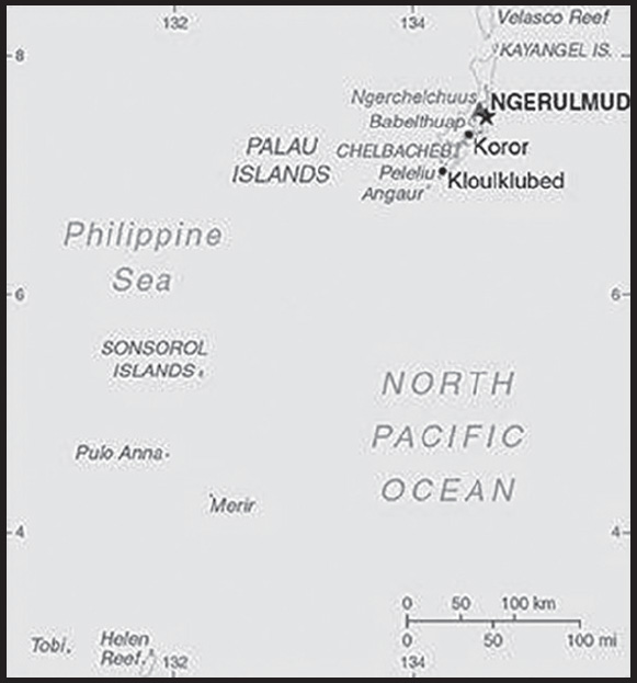
Location: Oceania, group of islands in the North Pacific Ocean, southeast of the Philippines
Geographic coordinates: 7 30 N, 134 30 E
Map references: Oceania
Area: total: 459 sq km
land: 459 sq km
water: 0 sq km
comparison ranking: total 197
Area - comparative: slightly more than 2.5 times the size of Washington, DC
Land boundaries: total: 0 km
Coastline: 1,519 km
Maritime claims: territorial sea: 12 nm
contiguous zone: 24 nm
exclusive economic zone: 200 nm
continental shelf: 200 nm
Climate: tropical; hot and humid; wet season May to November
Terrain: varying topography from the high, mountainous main island of Babelthuap to low, coral islands usually fringed by large barrier reefs
Elevation: highest point: Mount Ngerchelchuus 242 m
lowest point: Pacific Ocean 0 m
Natural resources: forests, minerals (especially gold), marine products, deep-seabed minerals
Land use: agricultural land: 10.8% (2018 est.)
arable land: 2.2% (2018 est.)
permanent crops: 4.3% (2018 est.)
permanent pasture: 4.3% (2018 est.)
forest: 87.6% (2018 est.)
other: 1.6% (2018 est.)
Irrigated land: 0 sq km (2022)
Population distribution: most of the population is located on the southern end of the main island of Babelthuap
Natural hazards: typhoons (June to December)
Geography - note: westernmost archipelago in the Caroline chain, consists of six island groups totaling more than 300 islands; includes World War II battleground of Beliliou (Peleliu) and world-famous Rock Islands
PEOPLE AND SOCIETY
Population: 21,779 (2023 est.)
comparison ranking: 218
Nationality: noun: Palauan(s)
adjective: Palauan
Ethnic groups: Palauan (Micronesian with Malayan and Melanesian admixtures) 70.6%, Carolinian 1.2%, Asian 26.5%, other 1.7% (2020 est.)
Languages: Palauan (official on most islands) 65.2%, other Micronesian 1.9%, English (official) 19.1%, Filipino 9.9%, Chinese 1.2%, other 2.8% (2015 est.)
note: Sonsoralese is official in Sonsoral; Tobian is official in Tobi; Angaur and Japanese are official in Angaur
Religions: Roman Catholic 46.9%, Protestant 30.9% (Evangelical 24.6%, Seventh Day Adventist 5%, other Protestant 1.4%), Modekngei 5.1% (indigenous to Palau), Muslim 4.9%, other 12.3% (2020 est.)
Age structure: 0-14 years: 17.49% (male 1,966/female 1,844)
15-64 years: 71.82% (male 8,665/female 6,976)
65 years and over: 10.69% (2023 est.) (male 581/female 1,747)
Dependency ratios: total dependency ratio: 43.8
youth dependency ratio: 30.2
elderly dependency ratio: 13.7
potential support ratio: 7.3 (2021)
Median age: total: 33.9 years (2020)
male: 32.9 years
female: 35.9 years
comparison ranking: total 94
Population growth rate: 0.39% (2023 est.)
comparison ranking: 161
Birth rate: 11.57 births/1,000 population (2023 est.)
comparison ranking: 161
Death rate: 8.31 deaths/1,000 population (2023 est.)
comparison ranking: 78
Net migration rate: 0.64 migrant(s)/1,000 population (2023 est.)
comparison ranking: 72
Population distribution: most of the population is located on the southern end of the main island of Babelthuap
Urbanization: urban population: 82.4% of total population (2023)
rate of urbanization: 1.59% annual rate of change (2020-25 est.)
Major urban areas - population: 277 NGERULMUD (capital) (2018)
Sex ratio: at birth: 1.07 male(s)/female
0-14 years: 1.07 male(s)/female
15-64 years: 1.24 male(s)/female
65 years and over: 0.33 male(s)/female
total population: 1.06 male(s)/female (2023 est.)
Infant mortality rate: total: 11.04 deaths/1,000 live births (2023 est.)
male: 12.99 deaths/1,000 live births
female: 8.98 deaths/1,000 live births
comparison ranking: total 126
Life expectancy at birth: total population: 74.91 years (2023 est.)
male: 71.76 years
female: 78.24 years
comparison ranking: total population 135
Total fertility rate: 1.7 children born/woman (2023 est.)
comparison ranking: 170
Gross reproduction rate: 0.82 (2023 est.)
Drinking water source: improved: urban: 99.6% of population
rural: 99.8% of population
total: 99.7% of population
unimproved: urban: 0.4% of population
rural: 0.2% of population
total: 0.3% of population (2020 est.)
Current health expenditure: 18.4% of GDP (2020)
Physicians density: 1.77 physicians/1,000 population (2020)
Sanitation facility access: improved: urban: 99.8% of population
rural: 99% of population
total: 99.6% of population
unimproved: urban: 0.2% of population
rural: 1% of population
total: 0.4% of population (2020 est.)
Obesity - adult prevalence rate: 55.3% (2016)
comparison ranking: 3
Tobacco use: total: 17.6% (2020 est.)
male: 27.3% (2020 est.)
female: 7.9% (2020 est.)
comparison ranking: total 95
Currently married women (ages 15-49): 45.6% (2023 est.)
Education expenditures: 6.8% of GDP (2019)
comparison ranking: 24
Literacy: definition: age 15 and over can read and write
total population: 96.6%
male: 96.8%
female: 96.3% (2015)
School life expectancy (primary to tertiary education): total: 17 years
male: 16 years
female: 17 years (2013)
Youth unemployment rate (ages 15-24): total: 5.6% (2014)
comparison ranking: total 185
ENVIRONMENT
Environment - current issues: inadequate facilities for disposal of solid waste; threats to the marine ecosystem from sand and coral dredging, illegal and destructive fishing practices, and overfishing; climate change contributes to rising sea level and coral bleaching; drought
Environment - international agreements: party to: Biodiversity, Climate Change, Climate Change-Kyoto Protocol, Climate Change-Paris Agreement, Comprehensive Nuclear Test Ban, Desertification, Endangered Species, Hazardous Wastes, Law of the Sea, Ozone Layer Protection, Ship Pollution, Wetlands, Whaling
signed, but not ratified: none of the selected agreements
Climate: tropical; hot and humid; wet season May to November
Land use: agricultural land: 10.8% (2018 est.)
arable land: 2.2% (2018 est.)
permanent crops: 4.3% (2018 est.)
permanent pasture: 4.3% (2018 est.)
forest: 87.6% (2018 est.)
other: 1.6% (2018 est.)
Urbanization: urban population: 82.4% of total population (2023)
rate of urbanization: 1.59% annual rate of change (2020-25 est.)
Revenue from forest resources: 0% of GDP (2018 est.)
comparison ranking: 169
Air pollutants: particulate matter emissions: 7.82 micrograms per cubic meter (2019 est.)
carbon dioxide emissions: 0.22 megatons (2016 est.)
methane emissions: 0.06 megatons (2020 est.)
Waste and recycling: municipal solid waste generated annually: 9,427 tons (2016 est.)
Total renewable water resources: 0 cubic meters (2017 est.)
GOVERNMENT
Country name: conventional long form: Republic of Palau
conventional short form: Palau
local long form: Beluu er a Belau
local short form: Belau
former: Trust Territory of the Pacific Islands, Palau District
etymology: from the Palauan name for the islands, Belau, which likely derives from the Palauan word “beluu” meaning “village”
Government type: presidential republic in free association with the US
Capital: name: Ngerulmud
geographic coordinates: 7 30 N, 134 37 E
time difference: UTC+9 (14 hours ahead of Washington, DC, during Standard Time)
etymology: the Palauan meaning is “place of fermented ‘mud’” (‘mud’ being the native name for the keyhole angelfish); the site of the new capitol (established in 2006) had been a large hill overlooking the ocean, Ngerulmud, on which women would communally gather to offer fermented angelfish to the gods
note: Ngerulmud, on Babeldaob Island, is the smallest national capital on earth by population, with only a few hundred people; the name is pronounced en-jer-al-mud; Koror, on Koror Island, with over 11,000 residents is by far the largest settlement in Palau; it served as the country’s capital from independence in 1994 to 2006
Administrative divisions: 16 states; Aimeliik, Airai, Angaur, Hatohobei, Kayangel, Koror, Melekeok, Ngaraard, Ngarchelong, Ngardmau, Ngatpang, Ngchesar, Ngeremlengui, Ngiwal, Peleliu, Sonsorol
Independence: 1 October 1994 (from the US-administered UN trusteeship)
National holiday: Constitution Day, 9 July (1981), day of a national referendum to pass the new constitution; Independence Day, 1 October (1994)
Constitution: history: ratified 9 July 1980, effective 1 January 1981
amendments: proposed by a constitutional convention (held at least once every 15 years with voter approval), by public petition of at least 25% of eligible voters, or by a resolution adopted by at least three fourths of National Congress members; passage requires approval by a majority of votes in at least three fourths of the states in the next regular general election; amended several times, last in 2020
Legal system: mixed legal system of civil, common, and customary law
International law organization participation: has not submitted an ICJ jurisdiction declaration; non-party state to the ICCt
Citizenship: citizenship by birth: no
citizenship by descent only: at least one parent must be a citizen of Palau
dual citizenship recognized: no
residency requirement for naturalization: note - no procedure for naturalization
Suffrage: 18 years of age; universal
Executive branch: chief of state: President Surangel WHIPPS Jr. (since 21 January 2021); Vice President Jerrlyn Uduch Sengebau SENIOR (since 21 January 2021); note - the president is both chief of state and head of government
head of government: President Surangel WHIPPS Jr. (since 21 January 2021); Vice President Jerrlyn Uduch Sengebau SENIOR (since 21 January 2021)
cabinet: Cabinet appointed by the president with the advice and consent of the Senate; also includes the vice president; the Council of Chiefs consists of chiefs from each of the states who advise the president on issues concerning traditional laws, customs, and their relationship to the constitution and laws of Palau
elections/appointments: president and vice president directly elected on separate ballots by absolute majority popular vote in 2 rounds if needed for a 4-year term (eligible for a second term); election last held on 3 November 2020 (next to be held in November 2024)
election results:
2020: Surangel WHIPPS, Jr. elected president in second round; percent of vote - Surangel WHIPPS, Jr. (independent) 56.7%, Raynold OILUCH (independent) 43.3%
2016: Tommy REMENGESAU reelected president; percent of vote - Tommy REMENGESAU (independent) 51.3%, Surangel WHIPPS, Jr.(independent) 48.7%; Antonio BELLS elected vice president
Legislative branch: description: bicameral National Congress or Olbiil Era Kelulau consists of:
Senate (13 seats; members directly elected in single-seat constituencies by majority vote to serve 4-year terms)
House of Delegates (16 seats; members directly elected in single-seat constituencies by simple majority vote to serve 4-year terms)
elections:
Senate - last held on 3 November 2020 (next to be held in November 2024)
House of Delegates - last held on 3 November 2020 (next to be held in November 2024)
election results:
Senate - percent of vote - NA; seats - independent 13; composition - men 12, women 1; percent of women 7.7% House of Delegates - percent of vote - NA; seats - independent 16; composition - men 15, women 1; percent of women 6.3%; note - overall percent of women in National Congress 6.9%
Judicial branch: highest court(s): Supreme Court (consists of the chief justice and 3 associate justices organized into appellate trial divisions; the Supreme Court organization also includes the Common Pleas and Land Courts)
judge selection and term of office: justices nominated by a 7-member independent body consisting of judges, presidential appointees, and lawyers and appointed by the president; judges can serve until mandatory retirement at age 65
subordinate courts: National Court and other ‘inferior’ courts
Political parties and leaders: none
International organization participation: ACP, ADB, AOSIS, FAO, IAEA, IBRD, ICAO, ICRM, IDA, IFC, IFRCS, ILO, IMF, IMO, IMSO, IOC, IPU, MIGA, OPCW, PIF, Sparteca, SPC, UN, UNAMID, UNCTAD, UNESCO, WHO
Diplomatic representation in the US: chief of mission: Ambassador Hersey KYOTA (since 12 November 1997)
chancery: 1701 Pennsylvania Avenue NW, Suite 200, Washington, DC 20006
telephone: [1] (202) 349-8598
FAX: [1] (202) 452-6281
email address and website:
consulate(s): Tamuning (Guam)
Diplomatic representation from the US: chief of mission: Ambassador (vacant); Chargé d’Affaires James BOUGHNER (since 9 September 2022)
embassy: Omsangel/Beklelachieb, Airai 96940
mailing address: 4260 Koror Place, Washington, DC 20521-4260
telephone: [680] 587-2920
FAX: [680] 587-2911
email address and website:
Flag description: light blue with a large yellow disk shifted slightly to the hoist side; the blue color represents the ocean, the disk represents the moon; Palauans consider the full moon to be the optimum time for human activity; it is also considered a symbol of peace, love, and tranquility
National symbol(s): bai (native meeting house); national colors: blue, yellow
National anthem: name: “Belau rekid” (Our Palau)
lyrics/music: multiple/Ymesei O. EZEKIEL
note: adopted 1980
National heritage: total World Heritage Sites: 1 (mixed)
selected World Heritage Site locales:Rock Islands Southern Lagoon
ECONOMY
Economic overview: high-income Pacific island economy; environmentally fragile; subsistence agriculture and fishing industries; US aid reliance; rebounding post-pandemic tourism industry and services sector; very high living standard and low unemployment
Real GDP (purchasing power parity): $248.468 million (2021 est.)
$286.694 million (2020 est.)
$315.42 million (2019 est.)
note: data are in 2017 dollars
comparison ranking: 220
Real GDP growth rate: -13.33% (2021 est.)
-9.11% (2020 est.)
0.4% (2019 est.)
comparison ranking: 221
Real GDP per capita: $13,800 (2021 est.) note: data are in 2017 dollars
$16,000 (2020 est.) note: data are in 2017 dollars
$17,600 (2019 est.)
comparison ranking: 118
GDP (official exchange rate): $292 million (2017 est.)
Inflation rate (consumer prices): 2.61% (2021 est.)
0.22% (2020 est.)
0.27% (2019 est.)
comparison ranking: 129
GDP - composition, by sector of origin: agriculture: 3% (2016 est.)
industry: 19% (2016 est.)
services: 78% (2016 est.)
comparison rankings: services 36; industry 159; agriculture 148
GDP - composition, by end use: household consumption: 60.5% (2016 est.)
government consumption: 27.2% (2016 est.)
investment in fixed capital: 22.7% (2016 est.)
investment in inventories: 1.9% (2016 est.)
exports of goods and services: 55.2% (2016 est.)
imports of goods and services: -67.6% (2016 est.)
Agricultural products: coconuts, cassava (manioc, tapioca), sweet potatoes; fish, pigs, chickens, eggs, bananas, papaya, breadfruit, calamansi, soursop, Polynesian chestnuts, Polynesian almonds, mangoes, taro, guava, beans, cucumbers, squash/pumpkins (various), eggplant, green onions, kangkong (watercress), cabbages (various), radishes, betel nuts, melons, peppers, noni, okra
Industries: tourism, fishing, subsistence agriculture
Industrial production growth rate: -3.42% (2021 est.)
comparison ranking: 181
Labor force: 11,610 (2016)
comparison ranking: 216
Labor force - by occupation: agriculture: 1.2%
industry: 12.4%
services: 86.4% (2016)
Unemployment rate: 1.7% (2015 est.)
4.1% (2012)
comparison ranking: 217
Youth unemployment rate (ages 15-24): total: 5.6% (2014)
comparison ranking: total 185
Population below poverty line: 24.9% (2006)
Budget: revenues: $122 million (2019 est.)
expenditures: $121 million (2019 est.)
Budget surplus (+) or deficit (-): 8.8% (of GDP) (2016 est.)
comparison ranking: 3
Public debt: 86.13% of GDP (2019 est.)
84.75% of GDP (2018 est.)
79.83% of GDP (2017 est.)
comparison ranking: 37
Taxes and other revenues: 18.59% (of GDP) (2020 est.)
comparison ranking: 103
Fiscal year: 1 October - 30 September
Current account balance: -$63.534 million (2021 est.)
-$106.379 million (2020 est.)
-$97.48 million (2019 est.)
comparison ranking: 88
Exports: $12.07 million (2021 est.)
$58.349 million (2020 est.)
$107.823 million (2019 est.)
comparison ranking: 217
Exports - partners: Japan 34%, Taiwan 16%, Turkey 16%, Italy 12%, United States 9% (2021)
Exports - commodities: computers, scrap vessels, recreational boats, scrap iron, fish, scrap copper, scrap aluminum (2021)
Imports: $180.38 million (2021 est.)
$215.97 million (2020 est.)
$226.594 million (2019 est.)
comparison ranking: 214
Imports - partners: China 34%, United States 21%, South Korea 12%, Japan 8%, Taiwan 6% (2021)
Imports - commodities: refined petroleum, boat propellers, iron structures, cars, floating docks, broadcasting equipment, prefabricated buildings (2021)
Reserves of foreign exchange and gold: $0 (31 December 2017 est.)
$580.9 million (31 December 2015 est.)
comparison ranking: 195
Debt - external: $18.38 billion (31 December 2014 est.)
$16.47 billion (31 December 2013 est.)
comparison ranking: 95
Exchange rates: 1 (2021 est.)
1 (2020 est.)
1 (2019 est.)
1 (2018 est.)
1 (2017 est.)
the US dollar is used
ENERGY
Electricity access: electrification - total population: 100% (2021)
COMMUNICATIONS
Telephones - fixed lines: total subscriptions: 8,000 (2021 est.)
subscriptions per 100 inhabitants: 44 (2021 est.)
comparison ranking: total subscriptions 193
Telephones - mobile cellular: total subscriptions: 24,000 (2021 est.)
subscriptions per 100 inhabitants: 130 (2021 est.)
comparison ranking: total subscriptions 214
Telecommunication systems: general assessment: Palau telecommunications is a small, formerly unregulated sector undertaking significant growth with the improvement and cost reduction in technology; mobile services have taken over the share of the market from landlines, with both 2-3G cell services throughout the islands; sim cards are easily available and offer 3G and data options; there are pre-paid and post-paid options for both voice and data; there are three data options for using a wireless hotspot network throughout Palau; connection from hotel and restaurant premises is available, enabling users to connect via WiFi throughout the main Islands of Palau (2022)
domestic: fixed-line nearly 44 per 100 and mobile-cellular services roughly 130 per 100 persons (2021)
international: country code - 680; landing point for the SEA-US submarine cable linking Palau, Philippines, Micronesia, Indonesia, Hawaii (US), Guam (US) and California (US); satellite earth station - 1 Intelsat (Pacific Ocean) (2019)
Broadcast media: no broadcast TV stations; a cable TV network covers the major islands and provides access to 4 local cable stations, rebroadcasts (on a delayed basis) of a number of US stations, as well as access to a number of real-time satellite TV channels; about a half dozen radio stations (1 government-owned) (2019)
Internet country code: .pw
Internet users: total: 6,696 (2021 est.)
percent of population: 37.2% (2021 est.)
comparison ranking: total 221
Broadband - fixed subscriptions: total: 1,224 (2015 est.)
subscriptions per 100 inhabitants: 7 (2015 est.)
comparison ranking: total 200
TRANSPORTATION
National air transport system: number of registered air carriers: 1 (2020)
inventory of registered aircraft operated by air carriers: 1
Civil aircraft registration country code prefix: T8
Airports: 3 (2021)
comparison ranking: total 194
Airports - with paved runways: 1
note: paved runways have a concrete or asphalt surface but not all have facilities for refueling, maintenance, or air traffic control; the length of a runway required for aircraft to safely operate depends on a number of factors including the type of aircraft, the takeoff weight (including passengers, cargo, and fuel), engine types, flap settings, landing speed, elevation of the airport, and average maximum daily air temperature; paved runways can reach a length of 5,000 m (16,000 ft.), but the “typical” length of a commercial airline runway is between 2,500-4,000 m (8,000-13,000 ft.)
Airports - with unpaved runways: 2
note: unpaved runways have a surface composition such as grass or packed earth and are most suited to the operation of light aircraft; unpaved runways are usually short, often less than 1,000 m (3,280 ft.) in length; airports with unpaved runways often lack facilities for refueling, maintenance, or air traffic control
Roadways: total: 125 km (2018)
paved: 89 km (2018)
unpaved: 36 km (2018)
comparison ranking: total 211
Merchant marine: total: 304 (2022)
by type: bulk carrier 29, container ship 6, general cargo 137, oil tanker 43, other 89
comparison ranking: total 55
Ports and terminals: major seaport(s): Koror
MILITARY AND SECURITY
Military and security forces: no regular military forces; the Ministry of Justice includes divisions/bureaus for public security, police functions, and maritime law enforcement (2023)
Military equipment inventories and acquisitions: since 2018, Australia and Japan have provided patrol boats to Palau’s Division of Marine Law Enforcement (2022)
Military - note: under the Compact of Free Association (COFA) between Palau and the US, the US is responsible for the defense of Palau and the US military is granted access to the islands, but it has not stationed any military forces there; the COFA also allows citizens of Palau to serve in the US armed forces
Palau has a “shiprider” agreement with the US, which allows local maritime law enforcement officers to embark on US Coast Guard (USCG) and US Navy (USN) vessels, including to board and search vessels suspected of violating laws or regulations within Palau’s designated exclusive economic zone (EEZ) or on the high seas; “shiprider” agreements also enable USCG personnel and USN vessels with embarked USCG law enforcement personnel to work with host nations to protect critical regional resources (2023)
TRANSNATIONAL ISSUES
Disputes - international: Palau-Indonesia: maritime delineation negotiations continue with Philippines, Indonesia
Palau-Philippines: maritime delineation negotiations continue with Philippines, Indonesia
PANAMA
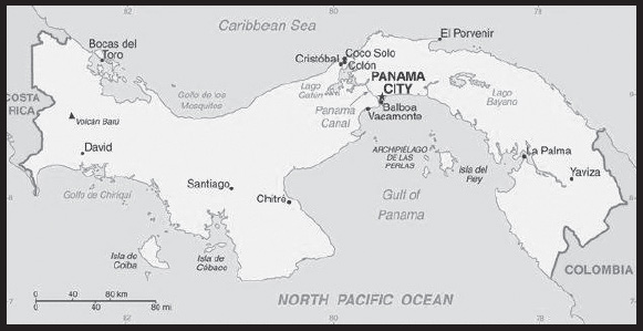
INTRODUCTION
Background: Explored and settled by the Spanish in the 16th century, Panama broke with Spain in 1821 and joined a union of Colombia, Ecuador, and Venezuela - named the Republic of Gran Colombia. When the latter dissolved in 1830, Panama remained part of Colombia. With US backing, Panama seceded from Colombia in 1903 and promptly signed a treaty with the US allowing for the construction of a canal and US sovereignty over a strip of land on either side of the structure (the Panama Canal Zone). The Panama Canal was built by the US Army Corps of Engineers between 1904 and 1914. In 1977, an agreement was signed for the complete transfer of the Canal from the US to Panama by the end of the century. Certain portions of the Zone and increasing responsibility over the Canal were turned over in the subsequent decades. With US help, dictator Manuel NORIEGA was deposed in 1989. The entire Panama Canal, the area supporting the Canal, and remaining US military bases were transferred to Panama by the end of 1999. An ambitious expansion project to more than double the Canal’s capacity - by allowing for more Canal transits and larger ships - was carried out between 2007 and 2016.
GEOGRAPHY
Location: Central America, bordering both the Caribbean Sea and the North Pacific Ocean, between Colombia and Costa Rica
Geographic coordinates: 9 00 N, 80 00 W
Map references: Central America and the Caribbean
Area: total: 75,420 sq km
land: 74,340 sq km
water: 1,080 sq km
comparison ranking: total 118
Area - comparative: slightly smaller than South Carolina
Land boundaries: total: 687 km
border countries (2): Colombia 339 km; Costa Rica 348 km
Coastline: 2,490 km
Maritime claims: territorial sea: 12 nm
contiguous zone: 24 nm
exclusive economic zone: 200 nm or edge of continental margin
Climate: tropical maritime; hot, humid, cloudy; prolonged rainy season (May to January), short dry season (January to May)
Terrain: interior mostly steep, rugged mountains with dissected, upland plains; coastal plains with rolling hills
Elevation: highest point: Volcan Baru 3,475 m
lowest point: Pacific Ocean 0 m
mean elevation: 360 m
Natural resources: copper, mahogany forests, shrimp, hydropower
Land use: agricultural land: 30.5% (2018 est.)
arable land: 7.3% (2018 est.)
permanent crops: 2.5% (2018 est.)
permanent pasture: 20.7% (2018 est.)
forest: 43.6% (2018 est.)
other: 25.9% (2018 est.)
Irrigated land: 407 sq km (2020)
Major lakes (area sq km): salt water lake(s): Laguna de Chiriqui - 900 sq km
Population distribution: population is concentrated towards the center of the country, particularly around the Canal, but a sizeable segment of the populace also lives in the far west around David; the eastern third of the country is sparsely inhabited
Natural hazards: occasional severe storms and forest fires in the Darien area
Geography - note: strategic location on eastern end of isthmus forming land bridge connecting North and South America; controls Panama Canal that links North Atlantic Ocean via Caribbean Sea with North Pacific Ocean
PEOPLE AND SOCIETY
Population: 4,404,108 (2023 est.)
comparison ranking: 127
Nationality: noun: Panamanian(s)
adjective: Panamanian
Ethnic groups: Mestizo (mixed Amerindian and White) 65%, Native American 12.3% (Ngabe 7.6%, Kuna 2.4%, Embera 0.9%, Bugle 0.8%, other 0.4%, unspecified 0.2%), Black or African descent 9.2%, Mulatto 6.8%, White 6.7% (2010 est.)
Languages: Spanish (official), indigenous languages (including Ngabere (or Guaymi), Buglere, Kuna, Embera, Wounaan, Naso (or Teribe), and Bri Bri), Panamanian English Creole (similar to Jamaican English Creole; a mixture of English and Spanish with elements of Ngabere; also known as Guari Guari and Colon Creole), English, Chinese (Yue and Hakka), Arabic, French Creole, other (Yiddish, Hebrew, Korean, Japanese); note - many Panamanians are bilingual
major-language sample(s):
La Libreta Informativa del Mundo, la fuente indispensable de información básica. (Spanish)
Religions: Roman Catholic 48.6%, Evangelical 30.2%, other 4.7%, agnostic 0.2%, atheist 0.2%, none 12.3%, unspecified 3.7% (2018 est.)
Demographic profile: Panama is a country of demographic and economic contrasts. It is in the midst of a demographic transition, characterized by steadily declining rates of fertility, mortality, and population growth, but disparities persist based on wealth, geography, and ethnicity. Panama has one of the fastest growing economies in Latin America and dedicates substantial funding to social programs, yet poverty and inequality remain prevalent. The indigenous population accounts for a growing share of Panama’s poor and extreme poor, while the non-indigenous rural poor have been more successful at rising out of poverty through rural-to-urban labor migration. The government’s large expenditures on untargeted, indirect subsidies for water, electricity, and fuel have been ineffective, but its conditional cash transfer program has shown some promise in helping to decrease extreme poverty among the indigenous population.
Panama has expanded access to education and clean water, but the availability of sanitation and, to a lesser extent, electricity remains poor. The increase in secondary schooling - led by female enrollment - is spreading to rural and indigenous areas, which probably will help to alleviate poverty if educational quality and the availability of skilled jobs improve. Inadequate access to sanitation contributes to a high incidence of diarrhea in Panama’s children, which is one of the main causes of Panama’s elevated chronic malnutrition rate, especially among indigenous communities.
Age structure: 0-14 years: 25.19% (male 569,439/female 540,143)
15-64 years: 64.87% (male 1,444,638/female 1,412,319)
65 years and over: 9.94% (2023 est.) (male 204,156/female 233,413)
Dependency ratios: total dependency ratio: 53.8
youth dependency ratio: 40.6
elderly dependency ratio: 13.2
potential support ratio: 7.6 (2021 est.)
Median age: total: 30.1 years (2020)
male: 29.6 years
female: 30.5 years
comparison ranking: total 123
Population growth rate: 1.51% (2023 est.)
comparison ranking: 64
Birth rate: 17.71 births/1,000 population (2023 est.)
comparison ranking: 82
Death rate: 5.88 deaths/1,000 population (2023 est.)
comparison ranking: 164
Net migration rate: 3.22 migrant(s)/1,000 population (2023 est.)
comparison ranking: 36
Population distribution: population is concentrated towards the center of the country, particularly around the Canal, but a sizeable segment of the populace also lives in the far west around David; the eastern third of the country is sparsely inhabited
Urbanization: urban population: 69.5% of total population (2023)
rate of urbanization: 1.92% annual rate of change (2020-25 est.)
Major urban areas - population: 1.977 million PANAMA CITY (capital) (2023)
Sex ratio: at birth: 1.06 male(s)/female
0-14 years: 1.05 male(s)/female
15-64 years: 1.02 male(s)/female
65 years and over: 0.87 male(s)/female
total population: 1.01 male(s)/female (2023 est.)
Maternal mortality ratio: 50 deaths/100,000 live births (2020 est.)
comparison ranking: 96
Infant mortality rate: total: 15.28 deaths/1,000 live births (2023 est.)
male: 16.53 deaths/1,000 live births
female: 13.96 deaths/1,000 live births
comparison ranking: total 96
Life expectancy at birth: total population: 78.44 years (2023 est.)
male: 75.6 years
female: 81.46 years
comparison ranking: total population 77
Total fertility rate: 2.37 children born/woman (2023 est.)
comparison ranking: 73
Gross reproduction rate: 1.15 (2023 est.)
Contraceptive prevalence rate: 50.8% (2014/15)
Drinking water source: improved: urban: 100% of population
rural: 88.1% of population
total: 96.2% of population
unimproved: urban: 0% of population
rural: 11.9% of population
total: 3.8% of population (2020 est.)
Current health expenditure: 9.7% of GDP (2020)
Physicians density: 1.63 physicians/1,000 population (2019)
Hospital bed density: 2.3 beds/1,000 population (2016)
Sanitation facility access: improved: urban: 95.5% of population
rural: 69.1% of population
total: 87.2% of population
unimproved: urban: 4.5% of population
rural: 30.9% of population
total: 12.8% of population (2020 est.)
Major infectious diseases: degree of risk: intermediate (2023)
food or waterborne diseases: bacterial diarrhea
vectorborne diseases: dengue fever
Obesity - adult prevalence rate: 22.7% (2016)
comparison ranking: 73
Alcohol consumption per capita: total: 6.54 liters of pure alcohol (2019 est.)
beer: 5.29 liters of pure alcohol (2019 est.)
wine: 0.02 liters of pure alcohol (2019 est.)
spirits: 1.2 liters of pure alcohol (2019 est.)
other alcohols: 0.02 liters of pure alcohol (2019 est.)
comparison ranking: total 63
Tobacco use: total: 5% (2020 est.)
male: 7.7% (2020 est.)
female: 2.2% (2020 est.)
comparison ranking: total 162
Children under the age of 5 years underweight: 3% (2019)
comparison ranking: 90
Currently married women (ages 15-49): 58.6% (2023 est.)
Education expenditures: 3.9% of GDP (2020 est.)
comparison ranking: 120
Literacy: definition: age 15 and over can read and write
total population: 95.7%
male: 98.8%
female: 95.4% (2019)
School life expectancy (primary to tertiary education): total: 13 years
male: 12 years
female: 13 years (2016)
Youth unemployment rate (ages 15-24): total: 30% (2021 est.)
male: 21.8%
female: 43.6%
comparison ranking: total 39
ENVIRONMENT
Environment - current issues: water pollution from agricultural runoff threatens fishery resources; deforestation of tropical rain forest; land degradation and soil erosion threatens siltation of Panama Canal; air pollution in urban areas; mining threatens natural resources
Environment - international agreements: party to: Antarctic-Marine Living Resources, Biodiversity, Climate Change, Climate Change-Kyoto Protocol, Climate Change-Paris Agreement, Comprehensive Nuclear Test Ban, Desertification, Endangered Species, Environmental Modification, Hazardous Wastes, Law of the Sea, Marine Dumping-London Convention, Nuclear Test Ban, Ozone Layer Protection, Ship Pollution, Tropical Timber 2006, Wetlands, Whaling
signed, but not ratified: Marine Life Conservation
Climate: tropical maritime; hot, humid, cloudy; prolonged rainy season (May to January), short dry season (January to May)
Land use: agricultural land: 30.5% (2018 est.)
arable land: 7.3% (2018 est.)
permanent crops: 2.5% (2018 est.)
permanent pasture: 20.7% (2018 est.)
forest: 43.6% (2018 est.)
other: 25.9% (2018 est.)
Urbanization: urban population: 69.5% of total population (2023)
rate of urbanization: 1.92% annual rate of change (2020-25 est.)
Revenue from forest resources: 0.08% of GDP (2018 est.)
comparison ranking: 121
Revenue from coal: 0% of GDP (2018 est.)
comparison ranking: 122
Air pollutants: particulate matter emissions: 11.78 micrograms per cubic meter (2019 est.)
carbon dioxide emissions: 10.71 megatons (2016 est.)
methane emissions: 5.97 megatons (2020 est.)
Waste and recycling: municipal solid waste generated annually: 1,472,262 tons (2015 est.)
Major lakes (area sq km): salt water lake(s): Laguna de Chiriqui - 900 sq km
Total water withdrawal: municipal: 760 million cubic meters (2020 est.)
industrial: 10 million cubic meters (2020 est.)
agricultural: 450 million cubic meters (2020 est.)
Total renewable water resources: 139.3 billion cubic meters (2020 est.)
GOVERNMENT
Country name: conventional long form: Republic of Panama
conventional short form: Panama
local long form: República de Panama
local short form: Panama
etymology: named after the capital city which was itself named after a former indigenous fishing village
Government type: presidential republic
Capital: name: Panama City
geographic coordinates: 8 58 N, 79 32 W
time difference: UTC-5 (same time as Washington, DC, during Standard Time)
etymology: according to tradition, the name derives from a former fishing area near the present capital - an indigenous village and its adjacent beach - that were called “panama” meaning “an abundance of fish”
Administrative divisions: 10 provinces (provincias, singular - provincia) and 4 indigenous regions* (comarcas); Bocas del Toro, Chiriqui, Cocle, Colon, Darien, Embera-Wounaan*, Guna Yala*, Herrera, Los Santos, Naso Tjer Di*, Ngabe-Bugle*, Panama, Panama Oeste, Veraguas
Independence: 3 November 1903 (from Colombia; became independent from Spain on 28 November 1821)
National holiday: Independence Day (Separation Day), 3 November (1903)
Constitution: history: several previous; latest effective 11 October 1972
amendments: proposed by the National Assembly, by the Cabinet, or by the Supreme Court of Justice; passage requires approval by one of two procedures: 1) absolute majority vote of the Assembly membership in each of three readings and by absolute majority vote of the next elected Assembly in a single reading without textual modifications; 2) absolute majority vote of the Assembly membership in each of three readings, followed by absolute majority vote of the next elected Assembly in each of three readings with textual modifications, and approval in a referendum; amended several times, last in 2004
Legal system: civil law system; judicial review of legislative acts in the Supreme Court of Justice
International law organization participation: accepts compulsory ICJ jurisdiction with reservations; accepts ICCt jurisdiction
Citizenship: citizenship by birth: yes
citizenship by descent only: yes
dual citizenship recognized: no
residency requirement for naturalization: 5 years
Suffrage: 18 years of age; universal
Executive branch: chief of state: President Laurentino “Nito” CORTIZO Cohen (since 1 July 2019); Vice President Jose Gabriel CARRIZO Jaen (since 1 July 2019); note - the president is both chief of state and head of government
head of government: President Laurentino “Nito” CORTIZO Cohen (since 1 July 2019); Vice President Jose Gabriel CARRIZO Jaen (since 1 July 2019)
cabinet: Cabinet appointed by the president
elections/appointments: president and vice president directly elected on the same ballot by simple majority popular vote for a 5-year term; president eligible for a single non-consecutive term); election last held on 5 May 2019 (next to be held in 2024)
election results:
2019: Laurentino “Nito” CORTIZO Cohen elected president; percent of vote - Laurentino CORTIZO Cohen (PRD) 33.3%, Romulo ROUX (CD) 31%, Ricardo LOMBANA (independent) 18.8%, Jose BLANDON (Panamenista Party) 10.8%, Ana Matilde GOMEZ Ruiloba (independent) 4.8%, other 1.3%
2014: Juan Carlos VARELA elected president; percent of vote - Juan Carlos VARELA (PP) 39.1%, Jose Domingo ARIAS (CD) 31.4%, Juan Carlos NAVARRO (PRD) 28.2%, other 1.3%
Legislative branch: description: unicameral National Assembly or Asamblea Nacional (71 seats; 45 members directly elected in multi-seat constituencies - populous towns and cities - by open list proportional representation vote and 26 directly elected in single-seat constituencies - outlying rural districts - by simple majority vote; members serve 5-year terms)
elections: last held on 5 May 2019 (next to be held in May 2024)
election results: percent of vote by party - NA; seats by party - PRD 35, CD 18, Panamenista 8, MOLIRENA 5, independent 5; composition - men 55, women 16, percent of women 22.5%
Judicial branch: highest court(s): Supreme Court of Justice or Corte Suprema de Justicia (consists of 9 magistrates and 9 alternates and divided into civil, criminal, administrative, and general business chambers)
judge selection and term of office: magistrates appointed by the president for staggered 10-year terms
subordinate courts: appellate courts or Tribunal Superior; Labor Supreme Courts; Court of Audit; circuit courts or Tribunal Circuital (2 each in 9 of the 10 provinces); municipal courts; electoral, family, maritime, and adolescent courts
Political parties and leaders: Alliance Party or PA [Jose MUNOZ Molina]
Alternative Independent Socialist Party or PAIS [Jose ALVAREZ]
Democratic Change or CD [Romulo ROUX]
Democratic Revolutionary Party or PRD [Benicio ROBINSON]
Nationalist Republican Liberal Movement or MOLIRENA [Francisco “Pancho” ALEMAN]
Panamenista Party [Jose Isabel BLANDON Figueroa] (formerly the Arnulfista Party)
Popular Party or PP [Daniel Javier BREA Clavel] (formerly Christian Democratic Party or PDC)
Realizing Goals Party or RM [Ricardo Alberto MARTINELLI Berrocal]
International organization participation: BCIE, CAN (observer), CD, CELAC, FAO, G-77, IADB, IAEA, IBRD, ICAO, ICC (national committees), ICCt, ICRM, IDA, IFAD, IFC, IFRCS, ILO, IMF, IMO, IMSO, Interpol, IOC, IOM, IPU, ISO, ITSO, ITU, ITUC (NGOs), LAES, LAIA, MIGA, NAM, OAS, OPANAL, OPCW, Pacific Alliance (observer), PCA, SICA, UN, UNASUR (observer), UNCTAD, UNESCO, UNIDO, Union Latina, UNWTO, UPU, WCO, WFTU (NGOs), WHO, WIPO, WMO, WTO
Diplomatic representation in the US: chief of mission: Ambassador Ramón Eduardo MARTÍNEZ DE LA GUARDIA (since 16 September 2022)
chancery: 2862 McGill Terrace NW, Washington, DC 20008
telephone: [1] (202) 483-1407
FAX: [1] (202) 483-8413
email address and website:
https://www.embassyofpanama.org/
consulate(s) general: Houston, Miami, Los Angeles, New Orleans, New York, Philadelphia, Tampa, Washington DC
Diplomatic representation from the US: chief of mission: Ambassador Mari Carmen APONTE (since 21 November 2022)
embassy: Building 783, Demetrio Basilio Lakas Avenue, Clayton
mailing address: 9100 Panama City PL, Washington, DC 20521-9100
telephone: [507] 317-5000
FAX: [507] 317-5568
email address and website:
Flag description: divided into four, equal rectangles; the top quadrants are white (hoist side) with a blue five-pointed star in the center and plain red; the bottom quadrants are plain blue (hoist side) and white with a red five-pointed star in the center; the blue and red colors are those of the main political parties (Conservatives and Liberals respectively) and the white denotes peace between them; the blue star stands for the civic virtues of purity and honesty, the red star signifies authority and law
National symbol(s): harpy eagle; national colors: blue, white, red
National anthem: name: “Himno Istmeno” (Isthmus Hymn)
lyrics/music: Jeronimo DE LA OSSA/Santos A. JORGE
note: adopted 1925
National heritage: total World Heritage Sites: 5 (2 cultural, 3 natural)
selected World Heritage Site locales:Caribbean Fortifications (c); Darien National Park (n); Talamanca Range-La Amistad National Park (n); Panamá Viejo and Historic District of Panamá (c); Coiba National Park (n)
ECONOMY
Economic overview: upper middle-income Central American economy; increasing Chinese trade; US dollar user; canal expansion fueling broader infrastructure investment; services sector dominates economy; historic money-laundering and illegal drug hub
Real GDP (purchasing power parity): $126.352 billion (2021 est.)
$109.551 billion (2020 est.)
$133.509 billion (2019 est.)
note: data are in 2017 dollars
comparison ranking: 84
Real GDP growth rate: 15.34% (2021 est.)
-17.94% (2020 est.)
2.98% (2019 est.)
comparison ranking: 8
Real GDP per capita: $29,000 (2021 est.)
$25,500 (2020 est.)
$31,500 (2019 est.)
note: data are in 2017 dollars
comparison ranking: 73
GDP (official exchange rate): $66.801 billion (2019 est.)
Inflation rate (consumer prices): 1.63% (2021 est.)
-1.55% (2020 est.)
-0.36% (2019 est.)
comparison ranking: 173
Credit ratings: Fitch rating: BBB (2011)
Moody’s rating: Baa1 (2019)
Standard & Poors rating: BBB (2020)
note: The year refers to the year in which the current credit rating was first obtained.
GDP - composition, by sector of origin: agriculture: 2.4% (2017 est.)
industry: 15.7% (2017 est.)
services: 82% (2017 est.)
comparison rankings: services 28; industry 176; agriculture 164
GDP - composition, by end use: household consumption: 45.6% (2017 est.)
government consumption: 10.7% (2017 est.)
investment in fixed capital: 42.9% (2017 est.)
investment in inventories: 3% (2017 est.)
exports of goods and services: 41.9% (2017 est.)
imports of goods and services: -44.2% (2017 est.)
Agricultural products: sugar cane, bananas, rice, poultry, milk, plantains, pineapples, maize, beef, pork
Industries: construction, brewing, cement and other construction materials, sugar milling
Industrial production growth rate: 37.5% (2021 est.)
comparison ranking: 1
Labor force: 1.966 million (2021 est.)
note: shortage of skilled labor, but an oversupply of unskilled labor
comparison ranking: 127
Labor force - by occupation: agriculture: 17%
industry: 18.6%
services: 64.4% (2009 est.)
Unemployment rate: 12.09% (2021 est.)
12.85% (2020 est.)
4.73% (2019 est.)
comparison ranking: 54
Youth unemployment rate (ages 15-24): total: 30% (2021 est.)
male: 21.8%
female: 43.6%
comparison ranking: total 39
Population below poverty line: 22.1% (2016 est.)
Gini Index coefficient - distribution of family income: 49.8 (2019 est.)
comparison ranking: 13
Average household expenditures: on food: 15.7% of household expenditures (2018 est.)
on alcohol and tobacco: 1.7% of household expenditures (2018 est.)
Household income or consumption by percentage share: lowest 10%: 1.1%
highest 10%: 38.9% (2014 est.)
Budget: revenues: $9.743 billion (2020 est.)
expenditures: $15.145 billion (2020 est.)
Budget surplus (+) or deficit (-): -1.6% (of GDP) (2017 est.)
comparison ranking: 92
Public debt: 37.8% of GDP (2017 est.)
37.4% of GDP (2016 est.)
comparison ranking: 142
Taxes and other revenues: 8.51% (of GDP) (2020 est.)
comparison ranking: 205
Fiscal year: calendar year
Current account balance: -$1.412 billion (2021 est.)
$1.097 billion (2020 est.)
-$3.329 billion (2019 est.)
comparison ranking: 143
Exports: $27.237 billion (2021 est.) note: data are in current year dollars
$20.179 billion (2020 est.) note: data are in current year dollars
$28.622 billion (2019 est.) note: data are in current year dollars
note: includes the Colon Free Zone
comparison ranking: 76
Exports - partners: Ecuador 20%, Guatemala 14%, China 8%, United States 6%, Netherlands 6% (2019)
Exports - commodities: refined petroleum, copper, bananas, ships, coal tar oil, packaged medicines (2019)
Imports: $24.627 billion (2021 est.) note: data are in current year dollars
$17.502 billion (2020 est.) note: data are in current year dollars
$27.599 billion (2019 est.) note: data are in current year dollars
note: includes the Colon Free Zone
comparison ranking: 81
Imports - partners: China 21%, United States 19%, Japan 16%, Colombia 6%, Ecuador 5% (2019)
Imports - commodities: ships, refined petroleum, crude petroleum, tanker ships, packaged medicines (2019)
Reserves of foreign exchange and gold: $9.614 billion (31 December 2020 est.)
$3.423 billion (31 December 2019 est.)
$2.121 billion (31 December 2018 est.)
comparison ranking: 83
Debt - external: $101.393 billion (2019 est.)
$94.898 billion (2018 est.)
comparison ranking: 55
Exchange rates: balboas (PAB) per US dollar -
1 (2021 est.)
1 (2020 est.)
1 (2019 est.)
1 (2018 est.)
1 (2017 est.)
ENERGY
Electricity access: population without electricity: (2020) less than 1 million
electrification - total population: 95.2% (2021)
electrification - urban areas: 99.7% (2021)
electrification - rural areas: 85.6% (2020)
Electricity: installed generating capacity: 4.106 million kW (2020 est.)
consumption: 10,808,780,000 kWh (2019 est.)
exports: 427 million kWh (2019 est.)
imports: 77 million kWh (2019 est.)
transmission/distribution losses: 1.309 billion kWh (2019 est.)
comparison rankings: installed generating capacity 95; transmission/distribution losses 103; imports 110; exports 77;
Electricity generation sources: fossil fuels: 24.5% of total installed capacity (2020 est.)
solar: 2.7% of total installed capacity (2020 est.)
wind: 6.4% of total installed capacity (2020 est.)
hydroelectricity: 66.2% of total installed capacity (2020 est.)
biomass and waste: 0.2% of total installed capacity (2020 est.)
Coal: production: 0 metric tons (2020 est.)
consumption: 1.118 million metric tons (2020 est.)
exports: 0 metric tons (2020 est.)
imports: 1.15 million metric tons (2020 est.)
proven reserves: 0 metric tons (2019 est.)
Petroleum: total petroleum production: 0 bbl/day (2021 est.)
refined petroleum consumption: 143,700 bbl/day (2019 est.)
Refined petroleum products - exports: 66 bbl/day (2015 est.)
comparison ranking: 121
Refined petroleum products - imports: 129,200 bbl/day (2015 est.)
comparison ranking: 45
Natural gas: production: 0 cubic meters (2021 est.)
consumption: 552.744 million cubic meters (2019 est.)
exports: 0 cubic meters (2021 est.)
imports: 552.744 million cubic meters (2019 est.)
proven reserves: 0 cubic meters (2021 est.)
Carbon dioxide emissions: 25.263 million metric tonnes of CO2 (2019 est.)
from coal and metallurgical coke: 1.905 million metric tonnes of CO2 (2019 est.)
from petroleum and other liquids: 22.281 million metric tonnes of CO2 (2019 est.)
from consumed natural gas: 1.077 million metric tonnes of CO2 (2019 est.)
comparison ranking: total emissions 79
Energy consumption per capita: 98.946 million Btu/person (2019 est.)
comparison ranking: 60
COMMUNICATIONS
Telephones - fixed lines: total subscriptions: 790,486 (2021 est.)
subscriptions per 100 inhabitants: 18 (2021 est.)
comparison ranking: total subscriptions 76
Telephones - mobile cellular: total subscriptions: 6,003,255 (2021 est.)
subscriptions per 100 inhabitants: 138 (2021 est.)
comparison ranking: total subscriptions 117
Telecommunication systems: general assessment: Panama has seen a steady increase in revenue from the telecom sector in recent years; mobile services and broadband remain the key growth sectors, with mobile connections accounting for 90% of all connections, and over half of telecom sector revenue; the mobile market has effective competition; internet services have grown in recent years as consumers responded to government fixed-line projects, improved mobile broadband connectivity and mobile applications (2021)
domestic: fixed-line is 18 per 100 and subscribership of mobile-cellular telephone is 138 per 100 (2021)
international: country code - 507; landing points for the PAN-AM, ARCOS, SAC, AURORA, PCCS, PAC, and the MAYA-1 submarine cable systems that together provide links to the US and parts of the Caribbean, Central America, and South America; satellite earth stations - 2 Intelsat (Atlantic Ocean); connected to the Central American Microwave System (2019)
Broadcast media: multiple privately owned TV networks and a government-owned educational TV station; multi-channel cable and satellite TV subscription services are available; more than 100 commercial radio stations (2019)
Internet country code: .pa
Internet users: total: 2.992 million (2021 est.)
percent of population: 68% (2021 est.)
comparison ranking: total 122
Broadband - fixed subscriptions: total: 562,413 (2020 est.)
subscriptions per 100 inhabitants: 13 (2020 est.)
comparison ranking: total 88
TRANSPORTATION
National air transport system: number of registered air carriers: 4 (2020)
inventory of registered aircraft operated by air carriers: 122
annual passenger traffic on registered air carriers: 12,939,350 (2018)
annual freight traffic on registered air carriers: 47.63 million (2018) mt-km
Civil aircraft registration country code prefix: HP
Airports: 117 (2021)
comparison ranking: total 49
Airports - with paved runways: 57
note: paved runways have a concrete or asphalt surface but not all have facilities for refueling, maintenance, or air traffic control; the length of a runway required for aircraft to safely operate depends on a number of factors including the type of aircraft, the takeoff weight (including passengers, cargo, and fuel), engine types, flap settings, landing speed, elevation of the airport, and average maximum daily air temperature; paved runways can reach a length of 5,000 m (16,000 ft.), but the “typical” length of a commercial airline runway is between 2,500-4,000 m (8,000-13,000 ft.)
Airports - with unpaved runways: 60
note: unpaved runways have a surface composition such as grass or packed earth and are most suited to the operation of light aircraft; unpaved runways are usually short, often less than 1,000 m (3,280 ft.) in length; airports with unpaved runways often lack facilities for refueling, maintenance, or air traffic control
Heliports: 3 (2021)
Pipelines: 128 km oil (2013)
Railways: total: 77 km (2014)
standard gauge: 77 km (2014) 1.435-m gauge
comparison ranking: total 129
Roadways: total: (2010)
paved: (2010)
unpaved: (2010)
Waterways: 800 km (2011) (includes the 82-km Panama Canal that is being widened)
comparison ranking: 78
Merchant marine: total: 8,025 (2022)
by type: bulk carrier 2,690, container ship 662, general cargo 1,418, oil tanker 785, other 2,470
comparison ranking: total 2
Ports and terminals: major seaport(s): Balboa, Colon, Cristobal
container port(s) (TEUs): Balboa (3,561,432), Colon (4,915,975) (2021)
MILITARY AND SECURITY
Military and security forces: no regular military forces; the paramilitary Panamanian Public Forces are under the Ministry of Public Security and include the Panama National Police (La Policía Nacional de Panamá, PNP), National Aeronaval Service (Servicio Nacional Aeronaval, SENAN), and National Border Service (Servicio Nacional de Fronteras, SENAFRONT) (2023)
note: the PNP includes a special forces directorate with counterterrorism and counternarcotics units; SENAFRONT has three regionally based border security brigades, plus a specialized brigade comprised of special forces, counternarcotics, maritime, and rapid reaction units
Military expenditures: 1.2% of GDP (2022 est.)
1.3% of GDP (2021 est.)
1.4% of GDP (2020 est.)
1.2% of GDP (2019)
1.1% of GDP (2018)
comparison ranking: 115
Military and security service personnel strengths: approximately 27,000 Ministry of Public Security personnel (2023)
Military equipment inventories and acquisitions: Panama’s security forces are lightly armed; Canada, Italy and the US have provided equipment to the security forces in recent years (2023)
Military - note: the Panama National Police is principally responsible for internal law enforcement and public order, while the National Border Service handles border security; the Aeronaval Service is responsible for carrying out naval and air operations that include some internal security responsibilities; key areas of focus are countering narcotics trafficking and securing the border, particularly along the southern border with Colombia where the National Border Service (SENAFRONT) maintains a significant presence
Panama created a paramilitary National Guard (Guardia Nacional de Panamá) in the 1950s from the former National Police (established 1904); the National Guard subsequently evolved into more of a military force with some police responsibilities; it seized power in a coup in 1968 and military officers ran the country until 1989; in 1983, the National Guard was renamed the Panama Defense Force (PDF); the PDF was disbanded after the 1989 US invasion and the current national police forces were formed in 1990; the armed forces were officially abolished under the 1994 Constitution (2023)
TRANSNATIONAL ISSUES
Disputes - international: Panama-Colombia: organized illegal narcotics operations in Colombia operate within the remote border region with Panama
Panama-Costa Rica: none identified
Refugees and internally displaced persons: refugees (country of origin): 147,424 (Venezuela) (economic and political crisis; includes Venezuelans who have claimed asylum or have received alternative legal stay) (2023)
Illicit drugs: not a major consumer or producer of illicit drugs; a prime sea and land passage for drugs, primarily cocaine, from South America to North America and Europe; drug traffickers also use millions of shipping containers to smuggle drugs to North America and Europe through the Panama
PAPUA NEW GUINEA
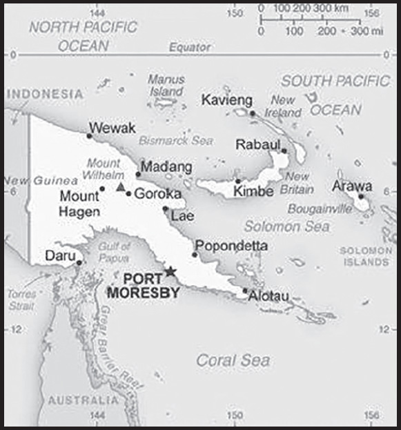
INTRODUCTION
Background: Papua New Guinea (PNG) was first settled between 50,000 and 60,000 years ago. PNG’s harsh geography consisting of mountains, jungles, and numerous river valleys, kept many of the arriving groups isolated, giving rise to PNG’s significant ethnic and linguistic diversity. Agriculture was independently developed by some of these groups. Around 500 B.C., Austronesian voyagers settled along the coast. Spanish and Portuguese explorers periodically visited the island starting in the 1500s, but none made it into the country’s interior. American and British whaling ships frequented the islands off the coast of New Guinea in the mid-1800s. In 1884, Germany declared a protectorate - and eventually a colony - over the northern part of what would become PNG and named it German New Guinea; days later the UK followed suit on the southern part and nearby islands and called it Papua. Most of their focus was on the coastal regions, leaving the highlands largely unexplored.
The UK put its colony under Australian administration in 1902 and formalized the act in 1906. At the outbreak of World War I, Australia occupied German New Guinea and continued to rule it after the war as a League of Nations Mandate. The discovery of gold along the Bulolo River in the 1920s led prospectors to venture into the highlands, where they found about 1 million people living in isolated communities. Japan invaded New Guinea in 1941 and reached Papua the following year. Allied victories during the New Guinea campaign pushed out the Japanese, and after the end of the war, Australia combined the two territories into one administration. Sir Michael SOMARE won elections in 1972 on the promise of achieving independence, which was realized in 1975.
A secessionist movement in Bougainville, an island well endowed in copper and gold resources, reignited in 1988 with debates about land use, profits, and an influx of outsiders at the Panguna Copper Mine. Following elections in 1992, the PNG Government took a hardline stance against Bougainville rebels and the resulting civil war led to about 20,000 deaths. In 1997, the PNG Government hired mercenaries to support its troops in Bougainville, sparking an army mutiny and forcing the prime minister to resign. PNG and Bougainville signed a truce in 1997 and a peace agreement in 2001, which granted Bougainville autonomy. An internationally-monitored nonbinding referendum asking Bougainvilleans to chose independence or greater self-rule occurred in November 2019, with 98% of voters opting for independence. However, the PNG Government and Bougainville officials remain in negotiations about the status of the island.
GEOGRAPHY
Location: Oceania, group of islands including the eastern half of the island of New Guinea between the Coral Sea and the South Pacific Ocean, east of Indonesia
Geographic coordinates: 6 00 S, 147 00 E
Map references: Oceania
Area: total: 462,840 sq km
land: 452,860 sq km
water: 9,980 sq km
comparison ranking: total 57
Area - comparative: slightly larger than California
Land boundaries: total: 824 km
border countries (1): Indonesia 824 km
Coastline: 5,152 km
Maritime claims: territorial sea: 12 nm
continental shelf: 200-m depth or to the depth of exploitation
exclusive fishing zone: 200 nm measured from claimed archipelagic baselines
Climate: tropical; northwest monsoon (December to March), southeast monsoon (May to October); slight seasonal temperature variation
Terrain: mostly mountains with coastal lowlands and rolling foothills
Elevation: highest point: Mount Wilhelm 4,509 m
lowest point: Pacific Ocean 0 m
mean elevation: 667 m
Natural resources: gold, copper, silver, natural gas, timber, oil, fisheries
Land use: agricultural land: 2.6% (2018 est.)
arable land: 0.7% (2018 est.)
permanent crops: 1.5% (2018 est.)
permanent pasture: 0.4% (2018 est.)
forest: 63.1% (2018 est.)
other: 34.3% (2018 est.)
Irrigated land: 0 sq km (2022)
Major rivers (by length in km): Sepik river source and mouth (shared with Indonesia) - 1,126 km; Fly river source and mouth (shared with Indonesia) - 1,050 km
Population distribution: population concentrated in the highlands and eastern coastal areas on the island of New Guinea; predominantly a rural distribution with only about one-fifth of the population residing in urban areas
Natural hazards: active volcanism; the country is subject to frequent and sometimes severe earthquakes; mud slides; tsunamis
volcanism: severe volcanic activity; Ulawun (2,334 m), one of Papua New Guinea’s potentially most dangerous volcanoes, has been deemed a Decade Volcano by the International Association of Volcanology and Chemistry of the Earth’s Interior, worthy of study due to its explosive history and close proximity to human populations; Rabaul (688 m) destroyed the city of Rabaul in 1937 and 1994; Lamington erupted in 1951 killing 3,000 people; Manam’s 2004 eruption forced the island’s abandonment; other historically active volcanoes include Bam, Bagana, Garbuna, Karkar, Langila, Lolobau, Long Island, Pago, St. Andrew Strait, Victory, and Waiowa; see note 2 under “Geography - note”
Geography - note: note 1: shares island of New Guinea with Indonesia; generally east-west trending highlands break up New Guinea into diverse ecoregions; one of world’s largest swamps along southwest coast
note 2: two major food crops apparently developed on the island of New Guinea: bananas and sugarcane
note 3: Papua New Guinea is one of the countries along the Ring of Fire, a belt of active volcanoes and earthquake epicenters bordering the Pacific Ocean; up to 90% of the world’s earthquakes and some 75% of the world’s volcanoes occur within the Ring of Fire
PEOPLE AND SOCIETY
Population: 9,819,350 (2023 est.)
comparison ranking: 93
Nationality: noun: Papua New Guinean(s)
adjective: Papua New Guinean
Ethnic groups: Melanesian, Papuan, Negrito, Micronesian, Polynesian
Languages: Tok Pisin (official), English (official), Hiri Motu (official), some 839 indigenous languages spoken (about 12% of the world’s total); many languages have fewer than 1,000 speakers
note: Tok Pisin, a creole language, is widely used and understood; English is spoken by 1%-2%; Hiri Motu is spoken by less than 2%
Religions: Protestant 64.3% (Evangelical Lutheran 18.4%, Seventh Day Adventist 12.9%, Pentecostal 10.4%, United Church 10.3%, Evangelical Alliance 5.9%, Anglican 3.2%, Baptist 2.8%, Salvation Army 0.4%), Roman Catholic 26%, other Christian 5.3%, non-Christian 1.4%, unspecified 3.1% (2011 est.)
note: data represent only the citizen population; roughly 0.3% of the population are non-citizens, consisting of Christian 52% (predominantly Roman Catholic), other 10.7%, none 37.3%
Age structure: 0-14 years: 37.34% (male 1,871,227/female 1,795,700)
15-64 years: 58.75% (male 2,917,668/female 2,851,691)
65 years and over: 3.9% (2023 est.) (male 189,851/female 193,213)
Dependency ratios: total dependency ratio: 60.5
youth dependency ratio: 55.5
elderly dependency ratio: 5
potential support ratio: 20.1 (2021 est.)
Median age: total: 24 years (2020)
male: 24 years
female: 24 years
comparison ranking: total 170
Population growth rate: 2.31% (2023 est.)
comparison ranking: 30
Birth rate: 28.54 births/1,000 population (2023 est.)
comparison ranking: 31
Death rate: 5.48 deaths/1,000 population (2023 est.)
comparison ranking: 183
Net migration rate: 0 migrant(s)/1,000 population (2023 est.)
comparison ranking: 97
Population distribution: population concentrated in the highlands and eastern coastal areas on the island of New Guinea; predominantly a rural distribution with only about one-fifth of the population residing in urban areas
Urbanization: urban population: 13.7% of total population (2023)
rate of urbanization: 2.91% annual rate of change (2020-25 est.)
Major urban areas - population: 410,000 PORT MORESBY (capital) (2023)
Sex ratio: at birth: 1.05 male(s)/female
0-14 years: 1.04 male(s)/female
15-64 years: 1.02 male(s)/female
65 years and over: 0.98 male(s)/female
total population: 1.03 male(s)/female (2023 est.)
Mother’s mean age at first birth: 21.9 years (2016/18)
note: data represents median age a first birth among women 25-49
Maternal mortality ratio: 192 deaths/100,000 live births (2020 est.)
comparison ranking: 47
Infant mortality rate: total: 32.81 deaths/1,000 live births (2023 est.)
male: 36.11 deaths/1,000 live births
female: 29.34 deaths/1,000 live births
comparison ranking: total 41
Life expectancy at birth: total population: 69.74 years (2023 est.)
male: 68.04 years
female: 71.52 years
comparison ranking: total population 177
Total fertility rate: 3.85 children born/woman (2023 est.)
comparison ranking: 30
Gross reproduction rate: 1.88 (2023 est.)
Contraceptive prevalence rate: 36.7% (2016/18)
Drinking water source: improved: urban: 86.2% of population
rural: 41.5% of population
total: 47.5% of population
unimproved: urban: 13.8% of population
rural: 58.5% of population
total: 52.5% of population (2020 est.)
Current health expenditure: 2.5% of GDP (2020)
Physicians density: 0.07 physicians/1,000 population (2019)
Sanitation facility access: improved: urban: 57.8% of population
rural: 18.2% of population
total: 23.5% of population
unimproved: urban: 42.2% of population
rural: 81.8% of population
total: 76.5% of population (2020 est.)
Major infectious diseases: degree of risk: very high (2023)
food or waterborne diseases: bacterial diarrhea, hepatitis A, and typhoid fever
vectorborne diseases: dengue fever and malaria
Obesity - adult prevalence rate: 21.3% (2016)
comparison ranking: 90
Alcohol consumption per capita: total: 1.26 liters of pure alcohol (2019 est.)
beer: 0.6 liters of pure alcohol (2019 est.)
wine: 0.06 liters of pure alcohol (2019 est.)
spirits: 0.6 liters of pure alcohol (2019 est.)
other alcohols: 0 liters of pure alcohol (2019 est.)
comparison ranking: total 144
Tobacco use: total: 39.3% (2020 est.)
male: 53.5% (2020 est.)
female: 25.1% (2020 est.)
comparison ranking: total 5
Currently married women (ages 15-49): 65.5% (2023 est.)
Child marriage: women married by age 15: 8%
women married by age 18: 27.3%
men married by age 18: 3.7% (2018 est.)
Education expenditures: 1.4% of GDP (2020 est.)
comparison ranking: 193
Literacy: definition: age 15 and over can read and write
total population: 64.2%
male: 65.6%
female: 62.8% (2015)
Youth unemployment rate (ages 15-24): total: 5.3% (2021 est.)
male: 6.3%
female: 4.2%
comparison ranking: total 187
People - note: the indigenous population of Papua New Guinea (PNG) is one of the most heterogeneous in the world; PNG has several thousand separate communities, most with only a few hundred people; divided by language, customs, and tradition, some of these communities have engaged in low-scale tribal conflict with their neighbors for millennia; the advent of modern weapons and modern migrants into urban areas has greatly magnified the impact of this lawlessness
ENVIRONMENT
Environment - current issues: rain forest loss as a result of growing commercial demand for tropical timber; unsustainable logging practices result in soil erosion, water quality degredation, and loss of habitat and biodiversity; large-scale mining projects cause adverse impacts on forests and water quality (discharge of heavy metals, cyanide, and acids into rivers); severe drought; inappropriate farming practices accelerate land degradion (soil erosion, siltation, loss of soil fertility); destructive fishing practices and coastal pollution due to run-off from land-based activities and oil spills
Environment - international agreements: party to: Antarctic Treaty, Biodiversity, Climate Change, Climate Change-Kyoto Protocol, Climate Change-Paris Agreement, Desertification, Endangered Species, Environmental Modification, Hazardous Wastes, Law of the Sea, Marine Dumping-London Convention, Nuclear Test Ban, Ozone Layer Protection, Ship Pollution, Tropical Timber 2006, Wetlands
signed, but not ratified: Comprehensive Nuclear Test Ban
Climate: tropical; northwest monsoon (December to March), southeast monsoon (May to October); slight seasonal temperature variation
Land use: agricultural land: 2.6% (2018 est.)
arable land: 0.7% (2018 est.)
permanent crops: 1.5% (2018 est.)
permanent pasture: 0.4% (2018 est.)
forest: 63.1% (2018 est.)
other: 34.3% (2018 est.)
Urbanization: urban population: 13.7% of total population (2023)
rate of urbanization: 2.91% annual rate of change (2020-25 est.)
Revenue from forest resources: 2.08% of GDP (2018 est.)
comparison ranking: 33
Revenue from coal: 0% of GDP (2018 est.)
comparison ranking: 95
Air pollutants: particulate matter emissions: 8.89 micrograms per cubic meter (2019 est.)
carbon dioxide emissions: 7.54 megatons (2016 est.)
methane emissions: 11.05 megatons (2020 est.)
Waste and recycling: municipal solid waste generated annually: 1 million tons (2014 est.)
municipal solid waste recycled annually: 20,000 tons (2016 est.)
percent of municipal solid waste recycled: 2% (2016 est.)
Major rivers (by length in km): Sepik river source and mouth (shared with Indonesia) - 1,126 km; Fly river source and mouth (shared with Indonesia) - 1,050 km
Total water withdrawal: municipal: 220 million cubic meters (2020 est.)
industrial: 170 million cubic meters (2020 est.)
agricultural: 1 million cubic meters (2020 est.)
Total renewable water resources: 801 billion cubic meters (2020 est.)
GOVERNMENT
Country name: conventional long form: Independent State of Papua New Guinea
conventional short form: Papua New Guinea
local short form: Papuaniugini
former: German New Guinea, British New Guinea, Territory of Papua and New Guinea
abbreviation: PNG
etymology: the word “papua” derives from the Malay “papuah” describing the frizzy hair of the Melanesians; Spanish explorer Ynigo ORTIZ de RETEZ applied the term “Nueva Guinea” to the island of New Guinea in 1545 after noting the resemblance of the locals to the peoples of the Guinea coast of Africa
Government type: parliamentary democracy under a constitutional monarchy; a Commonwealth realm
Capital: name: Port Moresby
geographic coordinates: 9 27 S, 147 11 E
time difference: UTC+10 (15 hours ahead of Washington, DC, during Standard Time)
time zone note: Papua New Guinea has two time zones, including Bougainville (UTC+11)
etymology: named in 1873 by Captain John MORESBY (1830-1922) in honor of his father, British Admiral Sir Fairfax MORESBY (1786-1877)
Administrative divisions: 20 provinces, 1 autonomous region*, and 1 district**; Bougainville*, Central, Chimbu, Eastern Highlands, East New Britain, East Sepik, Enga, Gulf, Hela, Jiwaka, Madang, Manus, Milne Bay, Morobe, National Capital**, New Ireland, Northern, Southern Highlands, Western, Western Highlands, West New Britain, West Sepik
Independence: 16 September 1975 (from the Australia-administered UN trusteeship)
National holiday: Independence Day, 16 September (1975)
Constitution: history: adopted 15 August 1975, effective at independence 16 September 1975
amendments: proposed by the National Parliament; passage has prescribed majority vote requirements depending on the constitutional sections being amended – absolute majority, two-thirds majority, or three-fourths majority; amended many times, last in 2016
Legal system: mixed legal system of English common law and customary law
International law organization participation: has not submitted an ICJ jurisdiction declaration; non-party state to the ICCt
Citizenship: citizenship by birth: no
citizenship by descent only: at least one parent must be a citizen of Papua New Guinea
dual citizenship recognized: no
residency requirement for naturalization: 8 years
Suffrage: 18 years of age; universal
Executive branch: chief of state: King CHARLES III (since 8 September 2022); represented by Governor General Grand Chief Sir Bob DADAE (since 28 February 2017)
head of government: Prime Minister James MARAPE (since 30 May 2019); Deputy Prime Minister John ROSSO (since 25 May 2022)
cabinet: National Executive Council appointed by the governor general on the recommendation of the prime minister
elections/appointments: the monarchy is hereditary; governor general nominated by the National Parliament and appointed by the chief of state; following legislative elections, the leader of the majority party or majority coalition usually appointed prime minister by the governor general pending the outcome of a National Parliament vote
election results: James MARAPE reelected prime minister; National Parliament vote - 105 out of 118
Legislative branch: description: unicameral National Parliament (118 seats; members directly elected in single-seat constituencies - 89 local, 20 provincial, the autonomous province of Bouganville, and the National Capital District - by majority preferential vote; members serve 5-year terms); note - the constitution allows up to 126 seats
elections: last held from 4-22 July 2022 (next to be held in June 2027)
election results: percent of vote by party - NA; seats by party - PANGU PATI - 38, PNC - 17, URP - 11, NAP - 5, PNC - 4, SDP - 4, PFP - 3, ULP - 3, Advance PNG - 2, National Party - 2, AP - 1, Destiny Party - 1, Greens - 1, Liberal Party - 1, MAP - 1, NGP - 1, ODP - 1, PLP - 1, PMC - 1, PPP - 1, PRP - 1, THE - 1, independents - 9; composition - NA
Judicial branch: highest court(s): Supreme Court (consists of the chief justice, deputy chief justice, 35 justices, and 5 acting justices); National Courts (consists of 13 courts located in the provincial capitals, with a total of 19 resident judges)
judge selection and term of office: Supreme Court chief justice appointed by the governor general upon advice of the National Executive Council (cabinet) after consultation with the National Justice Administration minister; deputy chief justice and other justices appointed by the Judicial and Legal Services Commission, a 5-member body that includes the Supreme Court chief and deputy chief justices, the chief ombudsman, and a member of the National Parliament; full-time citizen judges appointed for 10-year renewable terms; non-citizen judges initially appointed for 3-year renewable terms and after first renewal can serve until age 70; appointment and tenure of National Court resident judges NA
subordinate courts: district, village, and juvenile courts, military courts, taxation courts, coronial courts, mining warden courts, land courts, traffic courts, committal courts, grade five courts
Political parties and leaders: Advance PNG [Muglua DILU]
Allegiance Party or AP [Bryan KRAMER]
Destiny Party [Marsh NARAWEC]
Liberal Party [John PUNDARI]
Melanesian Alliance Party or MAP [Joseph YOPYYOPY]
National Alliance Party or NAP [Patrick PRUAITCH]
New Generation Party or NGP [Keith IDUHU]
Our Development Party or ODP [Charles ABEL]
Papua and Niugini Union Party or PANGU PATI [James MARAPE]
Papua New Guinea Country Party or PNGCP [Chris HAIVETA]
Papua New Guinea Greens Party [Richard MASERE]
Papua New Guinea National Party [Kerenga KUA]
Papua New Guinea Party or PNGP [Belden NAMAH]
People’s First Party or PFP [Richard MARU]
People’s Labor Party or PLP [Peter YAMA]
People’s Movement for Change or PMC [Gary JAFFA]
People’s National Congress Party or PNC [Peter Paire O’NEILL]
People’s Party or PP [Peter IPATAS]
People’s Progress Party or PPP [Sir Julius CHAN]
People’s Reform Party or PRP [James DONALD]
Social Democratic Party or SDP [Powes PARKOP]
Triumph Heritage Empowerment Party or THE [Don POLYE]
United Labor Party or ULP [Lekwa GURE]
United Resources Party or URP [William DUMA]
International organization participation: ACP, ADB, AOSIS, APEC, ARF, ASEAN (observer), C, CD, CP, EITI (candidate country), FAO, G-77, IAEA, IBRD, ICAO, ICRM, IDA, IFAD, IFC, IFRCS, IHO, ILO, IMF, IMO, Interpol, IOC, IOM, IPU, ISO (correspondent), ITSO, ITU, MIGA, NAM, OPCW, PIF, Sparteca, SPC, UN, UNCTAD, UNESCO, UNIDO, UNMISS, UNWTO, UPU, WCO, WFTU (NGOs), WHO, WIPO, WMO, WTO
Diplomatic representation in the US: chief of mission: Ambassador (vacant); Chargé d’Affaires Cephas KAYO, Minister (since 31 January 2018)
chancery: 1825 K Street NW, Suite 1010, Washington, DC 20006
telephone: [1] (202) 745-3680
FAX: [1] (202) 745-3679
email address and website:
Diplomatic representation from the US: chief of mission: Ambassador (vacant); Chargé d’Affaires Katherine Elizabeth “Kemy” MONAHAN (since 26 September 2023); note - also accredited to the Solomon Islands and Vanuatu
embassy: Harbour City Road, Port Moresby 121, NCD, Papua New Guinea
mailing address: Harbour City Road, Port Moresby 121, NCD, Papua New Guinea
telephone: [675] 308-2100
email address and website:
Flag description: divided diagonally from upper hoist-side corner; the upper triangle is red with a soaring yellow bird of paradise centered; the lower triangle is black with five, white, five-pointed stars of the Southern Cross constellation centered; red, black, and yellow are traditional colors of Papua New Guinea; the bird of paradise - endemic to the island of New Guinea - is an emblem of regional tribal culture and represents the emergence of Papua New Guinea as a nation; the Southern Cross, visible in the night sky, symbolizes Papua New Guinea’s connection with Australia and several other countries in the South Pacific
National symbol(s): bird of paradise; national colors: red, black
National anthem: name: “O Arise All You Sons”
lyrics/music: Thomas SHACKLADY
note: adopted 1975
National heritage: total World Heritage Sites: 1 (cultural)
selected World Heritage Site locales: Kuk Early Agricultural Site
ECONOMY
Economic overview: lower middle-income Pacific island economy; primarily informal agrarian sector; natural resource-rich; key liquified natural gas exporter; growing young workforce; slow post-pandemic recovery; increasingly impoverished citizenry; sustainable inflation
Real GDP (purchasing power parity): $36.589 billion (2021 est.)
$36.479 billion (2020 est.)
$37.672 billion (2019 est.)
note: data are in 2017 dollars
comparison ranking: 130
Real GDP growth rate: 0.3% (2021 est.)
-3.17% (2020 est.)
4.48% (2019 est.)
comparison ranking: 191
Real GDP per capita: $3,700 (2021 est.)
$3,700 (2020 est.)
$3,900 (2019 est.)
note: data are in 2017 dollars
comparison ranking: 190
GDP (official exchange rate): $19.82 billion (2017 est.)
Inflation rate (consumer prices): 4.48% (2021 est.)
4.87% (2020 est.)
3.93% (2019 est.)
comparison ranking: 78
Credit ratings: Moody’s rating: B2 (2016)
Standard & Poors rating: B- (2020)
note: The year refers to the year in which the current credit rating was first obtained.
GDP - composition, by sector of origin: agriculture: 22.1% (2017 est.)
industry: 42.9% (2017 est.)
services: 35% (2017 est.)
comparison rankings: services 219; industry 22; agriculture 40
GDP - composition, by end use: household consumption: 43.7% (2017 est.)
government consumption: 19.7% (2017 est.)
investment in fixed capital: 10% (2017 est.)
investment in inventories: 0.4% (2017 est.)
exports of goods and services: 49.3% (2017 est.)
imports of goods and services: -22.3% (2017 est.)
Agricultural products: oil palm fruit, bananas, coconuts, fruit, sweet potatoes, game meat, yams, roots/tubers nes, vegetables, taro
Industries: oil and gas; mining (gold, copper, and nickel); palm oil processing; plywood and wood chip production; copra crushing; construction; tourism; fishing; livestock (pork, poultry, cattle) and dairy farming; spice products (turmeric, vanilla, ginger, cardamom, chili, pepper, citronella, and nutmeg)
Industrial production growth rate: -7.5% (2020 est.)
comparison ranking: 194
Labor force: 3.073 million (2021 est.)
comparison ranking: 103
Labor force - by occupation: agriculture: 85%
Unemployment rate: 2.75% (2021 est.)
2.6% (2020 est.)
2.45% (2019 est.)
comparison ranking: 201
Youth unemployment rate (ages 15-24): total: 5.3% (2021 est.)
male: 6.3%
female: 4.2%
comparison ranking: total 187
Population below poverty line: 37% (2002 est.)
Gini Index coefficient - distribution of family income: 41.9 (2009 est.)
comparison ranking: 44
Household income or consumption by percentage share: lowest 10%: 1.7%
highest 10%: 40.5% (1996)
Budget: revenues: $4.039 billion (2019 est.)
expenditures: $5.135 billion (2019 est.)
Budget surplus (+) or deficit (-): -4.8% (of GDP) (2017 est.)
comparison ranking: 166
Public debt: 48.68% of GDP (2020 est.)
40.15% of GDP (2019 est.)
36.67% of GDP (2018 est.)
comparison ranking: 112
Taxes and other revenues: 11.88% (of GDP) (2020 est.)
comparison ranking: 178
Fiscal year: calendar year
Current account balance: $5.451 billion (2018 est.)
$5.348 billion (2017 est.)
$5.175 billion (2016 est.)
comparison ranking: 32
Exports: $11 billion (2021 est.)
$9.36 billion (2020 est.)
$11 billion (2019 est.)
note: data are in current year dollars
comparison ranking: 101
Exports - partners: Japan 25%, China 25%, Australia 16%, Taiwan 6%, South Korea 6% (2021)
Exports - commodities: natural gas, gold, copper, palm oil, nickel, crude petroleum, lumber, refined petroleum, tuna, coffee (2021)
Imports: $4.25 billion (2021 est.)
$3.77 billion (2020 est.)
$4.14 billion (2019 est.)
comparison ranking: 150
Imports - partners: Australia 27%, China 25%, Singapore 13%, Malaysia 8%, Indonesia 5% (2021)
Imports - commodities: refined petroleum, rice, delivery trucks, excavation machinery, motor vehicle parts (2021)
Reserves of foreign exchange and gold: $2.339 billion (31 December 2019 est.)
$2.239 billion (31 December 2018 est.)
$1.762 billion (31 December 2017 est.)
comparison ranking: 127
Debt - external: $17.94 billion (31 December 2017 est.)
$18.28 billion (31 December 2016 est.)
comparison ranking: 97
Exchange rates: kina (PGK) per US dollar -
Exchange rates: 3.509 (2021 est.)
3.46 (2020 est.)
3.388 (2019 est.)
3.293 (2018 est.)
3.189 (2017 est.)
ENERGY
Electricity access: electrification - total population: 20.9% (2021)
electrification - urban areas: 65.1% (2021)
electrification - rural areas: 14% (2021)
Electricity: installed generating capacity: 1.139 million kW (2020 est.)
consumption: 3,701,693,000 kWh (2019 est.)
exports: 0 kWh (2019 est.)
imports: 0 kWh (2019 est.)
transmission/distribution losses: 340 million kWh (2019 est.)
comparison rankings: installed generating capacity 132; transmission/distribution losses 139; imports 147; exports 134; consumption 134
Electricity generation sources: fossil fuels: 80.2% of total installed capacity (2020 est.)
hydroelectricity: 18.9% of total installed capacity (2020 est.)
biomass and waste: 1% of total installed capacity (2020 est.)
Petroleum: total petroleum production: 37,200 bbl/day (2021 est.)
refined petroleum consumption: 38,200 bbl/day (2019 est.)
crude oil and lease condensate exports: 60,300 bbl/day (2018 est.)
crude oil and lease condensate imports: 27,400 bbl/day (2018 est.)
crude oil estimated reserves: 159.7 million barrels (2021 est.)
Refined petroleum products - production: 22,170 bbl/day (2015 est.)
comparison ranking: 88
Refined petroleum products - exports: 0 bbl/day (2015 est.)
comparison ranking: 185
Refined petroleum products - imports: 17,110 bbl/day (2015 est.)
comparison ranking: 134
Natural gas: production: 11,784,065,000 cubic meters (2020 est.)
consumption: 166.984 million cubic meters (2020 est.)
exports: 11,764,498,000 cubic meters (2020 est.)
imports: 0 cubic meters (2021 est.)
proven reserves: 183.125 billion cubic meters (2021 est.)
Carbon dioxide emissions: 6.491 million metric tonnes of CO2 (2019 est.)
from petroleum and other liquids: 5.965 million metric tonnes of CO2 (2019 est.)
from consumed natural gas: 526,000 metric tonnes of CO2 (2019 est.)
comparison ranking: total emissions 128
Energy consumption per capita: 11.316 million Btu/person (2019 est.)
comparison ranking: 151
COMMUNICATIONS
Telephones - fixed lines: total subscriptions: 170,000 (2021 est.)
subscriptions per 100 inhabitants: 2 (2021 est.)
comparison ranking: total subscriptions 125
Telephones - mobile cellular: total subscriptions: 4.8 million (2021 est.)
subscriptions per 100 inhabitants: 48 (2021 est.)
comparison ranking: total subscriptions 125
Telecommunication systems: general assessment: fixed-line teledensity in Papua New Guinea has seen little change over the past two decades; progress in the country’s telecom sector has come primarily from mobile networks, where accessibility has expanded considerably in recent years, with population coverage increasing from less than 3% in 2006 to more than 90% by early 2021; the MNOs operate networks offering services based on GSM, 3G, and LTE, depending on location; GSM is prevalent in many rural and remote areas, while 3G and LTE are centered more on urban areas; MNOs’ investments in 4G are growing, though GSM still represents the bulk of all mobile connections owing to the low penetration of smartphones and the concentration of high-speed data networks predominantly in high value urban areas; a lack of sufficient competition and investment in the wire line segment has driven up prices and hampered network coverage and quality; infrastructure deployment costs are high, partly due to the relatively low subscriber base, the difficult terrain, and the high proportion of the population living in rural areas; fixed telecom infrastructure is almost non-existent outside urban centers, leaving most of the population under served; PNG is the Pacific region’s largest poorly developed telecom market, with only around 22% of its people connected to the internet; this falls far behind the recommended targets set in the country’s National Broadband Policy drafted in 2013, which aimed to provide broadband access to 90% of the total population by 2018; the existing submarine cable infrastructure is insufficient to serve the country’s needs; low international capacity has meant that internet services are expensive and slow; the cable links PNG to the Solomon Islands and Australia (landing at Sydney); despite the improvement in recent years, the country is still impacted by a connectivity infrastructure deficit, making it reliant on more expensive alternatives such as satellites, also weighing on the affordability of services for end-users (2022)
domestic: fixed-line nearly 2 per 100 and mobile-cellular is 48 per 100 persons (2021)
international: country code - 675; landing points for the Kumul Domestic Submarine Cable System, PNG-LNG, APNG-2, CSCS and the PPC-1 submarine cables to Australia, Guam, PNG and Solomon Islands; satellite earth station - 1 Intelsat (Pacific Ocean) (2019)
Broadcast media: 4 TV stations: 1 commercial station operating since 1987, 1 state-run station launched in 2008, 1 digital free-to-view network launched in 2014, and 1 satellite network Click TV (PNGTV) launched in 2015; the state-run National Broadcasting Corporation operates 3 radio networks with multiple repeaters and about 20 provincial stations; several commercial radio stations with multiple transmission points as well as several community stations; transmissions of several international broadcasters are accessible (2018)
Internet country code: .pg
Internet users: total: 3.168 million (2021 est.)
percent of population: 32% (2021 est.)
comparison ranking: total 116
Broadband - fixed subscriptions: total: 21,000 (2020 est.)
subscriptions per 100 inhabitants: 0.2 (2020 est.)
comparison ranking: total 165
TRANSPORTATION
National air transport system: number of registered air carriers: 6 (2020)
inventory of registered aircraft operated by air carriers: 48
annual passenger traffic on registered air carriers: 964,713 (2018)
annual freight traffic on registered air carriers: 30.93 million (2018) mt-km
Civil aircraft registration country code prefix: P2
Airports: 561 (2021)
comparison ranking: total 11
Airports - with paved runways: 21
note: paved runways have a concrete or asphalt surface but not all have facilities for refueling, maintenance, or air traffic control; the length of a runway required for aircraft to safely operate depends on a number of factors including the type of aircraft, the takeoff weight (including passengers, cargo, and fuel), engine types, flap settings, landing speed, elevation of the airport, and average maximum daily air temperature; paved runways can reach a length of 5,000 m (16,000 ft.), but the “typical” length of a commercial airline runway is between 2,500-4,000 m (8,000-13,000 ft.)
Airports - with unpaved runways: 540
note: unpaved runways have a surface composition such as grass or packed earth and are most suited to the operation of light aircraft; unpaved runways are usually short, often less than 1,000 m (3,280 ft.) in length; airports with unpaved runways often lack facilities for refueling, maintenance, or air traffic control
Heliports: 2 (2021)
Pipelines: 264 km oil (2013)
Roadways: total: 9,349 km (2011)
paved: 3,000 km (2011)
unpaved: 6,349 km (2011)
comparison ranking: total 137
Waterways: 11,000 km (2011)
comparison ranking: 14
Merchant marine: total: 199 (2022)
by type: container ship 6, general cargo 87, oil tanker 3, other 103
comparison ranking: total 65
Ports and terminals: major seaport(s): Kimbe, Lae, Madang, Rabaul, Wewak
LNG terminal(s) (export): Port Moresby
MILITARY AND SECURITY
Military and security forces: Papua New Guinea Defense Force (PNGDF): Land Element, Maritime Element, Air Element
Ministry of Internal Security: Royal Papua New Guinea Constabulary (RPNGC) (2023)
Military expenditures: 0.3% of GDP (2022 est.)
0.4% of GDP (2021 est.)
0.4% of GDP (2020 est.)
0.3% of GDP (2019 est.)
0.3% of GDP (2018 est.)
comparison ranking: 164
Military and security service personnel strengths: approximately 2,500 active-duty PNGDF troops (2023)
Military equipment inventories and acquisitions: the PNGDF is lightly armed; most of its military assistance has come from Australia (2023)
Military service age and obligation: 18-27 for voluntary military service for men and women; no conscription (2023)
Military - note: the PNGDF is a small and lightly armed force tasked with defense of the country and its territories against external attack, as well as internal security and socio-economic development duties; the Land Element includes two infantry battalions, plus small supporting engineer, communications, explosive ordnance disposal, and medical forces; the Air Element is a small air wing operating a light transport aircraft and two leased helicopters, while the Maritime Element consists of a few patrol boats and landing craft
the PNGDF was established in 1973, and its primary combat unit, the Royal Pacific Islands Regiment (RPIR), is descended from Australian Army infantry battalions comprised of native soldiers and led by Australian officers and noncommissioned officers formed during World War II to help fight the Japanese; the RPIR was disbanded after the war, but reestablished in 1951 as part of the Australian Army where it continued to serve until Papua New Guinea gained its independence in 1975, when it became part of the PNGDF
Papua New Guinea’s traditional security partners are Australia, Indonesia, New Zealand, and the US; Australia and the US are assisting the country with expanding and improving the Defense Force naval base at Lombrum on Manus Island; the US first established a Lombrum base in 1944 during World War II; in recent years, Papua New Guinea has established security ties with France and the UK; the US and PNG signed a defense cooperation agreement in May 2023, which included a shiprider agreement that provides the opportunity for PNG personnel to work on US Coast Guard and US Navy vessels, and vice versa, to tackle maritime crime such as illegal fishing (2023)
TRANSNATIONAL ISSUES
Disputes - international: Papua New Guinea-Australia: relies on assistance from Australia to keep out illegal cross-border activities from primarily Indonesia, including goods smuggling, illegal narcotics trafficking, and squatters and secessionists
Refugees and internally displaced persons: refugees (country of origin): 11,432 (Indonesia) (mid-year 2022)
IDPs: 91,000 (tribal conflict, inter-communal violence) (2022)
stateless persons: 15 (2022)
Trafficking in persons: tier rating: Tier 2 Watch List — Papua New Guinea does not fully meet the minimum standards for the elimination of trafficking but is making significant efforts to do so; for the first time in four years, the government initiated prosecutions against four alleged traffickers, and identified and provided protective services to a child sex trafficking victim; however, the government did not demonstrate overall increasing efforts compared to the previous year; officials did not convict any traffickers, nor provide shelter or services to victims or help NGOs do so; endemic corruption and complicity, particularly in the logging and fishing sectors, left foreigners and locals vulnerable to sex trafficking and forced labor; the lack of resources for anti-trafficking efforts, low awareness among officials and the public, and lack of training activities continued to hinder progress; the government did not update standard operating procedures for victim identification or allocate funding to its national action plan; therefore, Papua New Guinea remained on Tier 2 Watch List for the second consecutive year (2022)
trafficking profile: human traffickers exploit domestic and foreign victims in Papua New Guinea, and Papua New Guineans are exploited abroad; traffickers use Papua New Guinea as a transit point to exploit foreign victims in other countries; foreign and local women and children are exploited in sex trafficking and in forced labor in domestic service, the tourism sector, manual labor, begging, and street vending; families or tribe members reportedly exploit children in sex trafficking or forced labor; some parents force their daughters in to marriages or child sex trafficking to resolve debts or disputes; Chinese, Malaysian, and local men are forced to work in logging and mining camps; migrant women from Malaysia, Thailand, China, and the Philippines are subjected to sex trafficking and domestic servitude at logging and mining camps, fisheries, and entertainment sites (2022)
Illicit drugs: transit point for smuggling drugs such as methamphetamine and cocaine; major consumer of cannabis
PARACEL ISLANDS
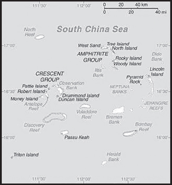
INTRODUCTION
Background: The Paracel Islands are surrounded by productive fishing grounds and by potential oil and gas reserves. In 1932, French Indochina annexed the islands and set up a weather station on Pattle Island; maintenance was continued by its successor, Vietnam. China has occupied all the Paracel Islands since 1974, when its troops seized a South Vietnamese garrison occupying the western islands. China built a military installation on Woody Island with an airfield and artificial harbor, and has scattered garrisons on some of the other islands. The Paracel islands also are claimed by Taiwan and Vietnam.
GEOGRAPHY
Location: Southeastern Asia, group of small islands and reefs in the South China Sea, about one-third of the way from central Vietnam to the northern Philippines
Geographic coordinates: 16 30 N, 112 00 E
Map references: Southeast Asia
Area: total: 8 sq km ca.
land: 7.75 sq km ca.
water: 0 sq km
comparison ranking: total 243
Area - comparative: land area is about 13 times the size of the National Mall in Washington, DC
Land boundaries: total: 0 km
Coastline: 518 km
Maritime claims: NA
Climate: tropical
Terrain: mostly low and flat
Elevation: highest point: unnamed location on Rocky Island 14 m
lowest point: South China Sea 0 m
Natural resources: none
Land use: other: 100% (2018 est.)
Irrigated land: 0 sq km (2022)
Population distribution: a population of over 1,000 Chinese resides on Woody Island, the largest of the Paracels; there are scattered Chinese garrisons on some other islands
Natural hazards: typhoons
Geography - note: composed of 130 small coral islands and reefs divided into the northeast Amphitrite Group and the western Crescent Group
PEOPLE AND SOCIETY
Population: 1,440 (July 2014 est.)
note: Chinese activity has increased in recent years, particularly on Woody Island, where the population exceeds 1,000; there are scattered Chinese garrisons on some other islands
comparison ranking: 234
Population growth rate: 0.75% (2021 est.)
comparison ranking: 120
Birth rate: Net migration rate
-0.66 migrant(s)/1,000 population (2021 est.)
comparison ranking: 131
Population distribution: a population of over 1,000 Chinese resides on Woody Island, the largest of the Paracels; there are scattered Chinese garrisons on some other islands
ENVIRONMENT
Environment - current issues: China’s use of dredged sand and coral to build artificial islands harms reef systems; ongoing human activities, including military operations, infrastructure construction, and tourism endangers local ecosystem including birds, fish, marine mammals, and marine reptiles
Climate: tropical
Land use: other: 100% (2018 est.)
GOVERNMENT
Country name: conventional long form: none
conventional short form: Paracel Islands
etymology: Portuguese navigators began to refer to the “Ilhas do Pracel” in the 16th century as a designation of low lying islets, sandbanks, and reefs scattered over a wide area; over time the name changed to “parcel” and then “paracel”
TRANSPORTATION
Airports: 1 (2021)
comparison ranking: total 220
Airports - with paved runways: 1
civil airports: 0
military airports: 1 (controlled by China)
joint use (civil-military) airports: 0
other airports: 0
note 1: paved runways have a concrete or asphalt surface but not all have facilities for refueling, maintenance, or air traffic control; the length of a runway required for aircraft to safely operate depends on a number of factors including the type of aircraft, the takeoff weight (including passengers, cargo, and fuel), engine types, flap settings, landing speed, elevation of the airport, and average maximum daily air temperature; paved runways can reach a length of 5,000 m (16,000 ft.), but the “typical” length of a commercial airline runway is between 2,500-4,000 m (8,000-13,000 ft.)
note 2: controlled by China
Ports and terminals: small Chinese port facilities on Woody Island and Duncan Island
MILITARY AND SECURITY
Military - note: occupied by China, which is assessed to maintain 20 outposts in the Paracels (Antelope, Bombay, and North reefs; Drummond, Duncan, Lincoln, Middle, Money, North, Pattle, Quanfu, Robert, South, Tree, Triton, Woody, and Yagong islands; South Sand and West Sand; Observation Bank); the outposts range in size from one or two buildings to bases with significant military infrastructure; Woody Island is the main base in the Paracels and includes an airstrip with fighter aircraft hangers, naval facilities, surveillance radars, and defenses such as surface-to-air missiles and anti-ship cruise missiles; combat aircraft have deployed to the island (2023)
TRANSNATIONAL ISSUES
Disputes - international: Paracel Islands-China-Taiwan-Vietnam: occupied by China, also claimed by Taiwan and Vietnam
PARAGUAY
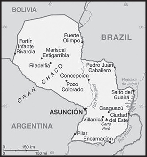
INTRODUCTION
Background: Several Indigenous groups, principally belonging to the Guarani language family, inhabited the area of modern Paraguay before the arrival of the Spanish in the early 16th century, when the territory was incorporated into the Viceroyalty of Peru. Paraguay achieved its independence from Spain in 1811 with the help of neighboring states. In the aftermath of independence, a series of military dictators ruled the country until 1870. During the disastrous War of the Triple Alliance (1864-70) - fought against Argentina, Brazil, and Uruguay - Paraguay lost two thirds of its adult males and much of its territory. The country stagnated economically for the next half century and experienced a tumultuous series of political regimes. Following the Chaco War of 1932-35 with Bolivia, Paraguay gained a large part of the Chaco lowland region. The 35-year military dictatorship of Alfredo STROESSNER ended in 1989, and Paraguay has held relatively free and regular presidential elections since the country’s return to democracy.
GEOGRAPHY
Location: Central South America, northeast of Argentina, southwest of Brazil
Geographic coordinates: 23 00 S, 58 00 W
Map references: South America
Area: total: 406,752 sq km
land: 397,302 sq km
water: 9,450 sq km
comparison ranking: total 61
Area - comparative: about three times the size of New York state; slightly smaller than California
Land boundaries: total: 4,655 km
border countries (3): Argentina 2,531 km; Bolivia 753 km; Brazil 1,371 km
Coastline: 0 km (landlocked)
Maritime claims: none (landlocked)
Climate: subtropical to temperate; substantial rainfall in the eastern portions, becoming semiarid in the far west
Terrain: grassy plains and wooded hills east of Rio Paraguay; Gran Chaco region west of Rio Paraguay mostly low, marshy plain near the river, and dry forest and thorny scrub elsewhere
Elevation: highest point: Cerro Pero 842 m
lowest point: junction of Río Paraguay and Río Paraná 46 m
mean elevation: 178 m
Natural resources: hydropower, timber, iron ore, manganese, limestone
Land use: agricultural land: 53.8% (2018 est.)
arable land: 10.8% (2018 est.)
permanent crops: 0.2% (2018 est.)
permanent pasture: 42.8% (2018 est.)
forest: 43.8% (2018 est.)
other: 2.4% (2018 est.)
Irrigated land: 1,362 sq km (2012)
Major rivers (by length in km): Río de la Plata/Paraná (shared with Brazil [s], Argentina, and Uruguay [m]) - 4,880 km; Paraguay river mouth (shared with Brazil [s] and Argentina) - 2,549 km
note – [s] after country name indicates river source; [m] after country name indicates river mouth
Major watersheds (area sq km): Atlantic Ocean drainage: Paraná (2,582,704 sq km)
Major aquifers: Guarani Aquifer System
Population distribution: most of the population resides in the eastern half of the country; to the west lies the Gran Chaco (a semi-arid lowland plain), which accounts for 60% of the land territory, but only 2% of the overall population
Natural hazards: local flooding in southeast (early September to June); poorly drained plains may become boggy (early October to June)
Geography - note: note 1: landlocked; lies between Argentina, Bolivia, and Brazil; population concentrated in eastern and southern part of country
note 2: pineapples are probably indigenous to the southern Brazil-Paraguay region
PEOPLE AND SOCIETY
Population: 7,439,863 (2023 est.)
comparison ranking: 104
Nationality: noun: Paraguayan(s)
adjective: Paraguayan
Ethnic groups: Mestizo (mixed Spanish and Amerindian ancestry) 95%, other 5%
Languages: Spanish (official) and Guarani (official) 46.3%, only Guarani 34%, only Spanish 15.2%, other (includes Portuguese, German, other Indigenous languages) 4.1%, no response 0.4%; note - data represent predominant household language (2012 est.)
major-language sample(s):
La Libreta Informativa del Mundo, la fuente indispensable de información básica. (Spanish)
Religions: Roman Catholic 89.6%, Protestant 6.2%, other Christian 1.1%, other or unspecified 1.9%, none 1.1% (2002 est.)
Demographic profile: Paraguay falls below the Latin American average in several socioeconomic categories, including immunization rates, potable water, sanitation, and secondary school enrollment, and has greater rates of income inequality and child and maternal mortality. Paraguay’s poverty rate has declined in recent years but remains high, especially in rural areas, with more than a third of the population below the poverty line. However, the well-being of the poor in many regions has improved in terms of housing quality and access to clean water, telephone service, and electricity. The fertility rate continues to drop, declining sharply from an average 4.3 births per woman in the late 1990s to about 2 in 2013, as a result of the greater educational attainment of women, increased use of contraception, and a desire for smaller families among young women.
Paraguay is a country of emigration; it has not attracted large numbers of immigrants because of political instability, civil wars, years of dictatorship, and the greater appeal of neighboring countries. Paraguay first tried to encourage immigration in 1870 in order to rebound from the heavy death toll it suffered during the War of the Triple Alliance, but it received few European and Middle Eastern immigrants. In the 20th century, limited numbers of immigrants arrived from Lebanon, Japan, South Korea, and China, as well as Mennonites from Canada, Russia, and Mexico. Large flows of Brazilian immigrants have been arriving since the 1960s, mainly to work in agriculture. Paraguayans continue to emigrate to Argentina, Brazil, Uruguay, the United States, Italy, Spain, and France.
Age structure: 0-14 years: 22.4% (male 847,721/female 818,983)
15-64 years: 68.54% (male 2,560,031/female 2,539,378)
65 years and over: 9.06% (2023 est.) (male 320,958/female 352,792)
Dependency ratios: total dependency ratio: 54.4
youth dependency ratio: 44.8
elderly dependency ratio: 9.6
potential support ratio: 10.4 (2021 est.)
Median age: total: 29.7 years (2020)
male: 29.5 years
female: 29.9 years
comparison ranking: total 128
Population growth rate: 1.12% (2023 est.)
comparison ranking: 82
Birth rate: 16.15 births/1,000 population (2023 est.)
comparison ranking: 99
Death rate: 4.9 deaths/1,000 population (2023 est.)
comparison ranking: 197
Net migration rate: -0.07 migrant(s)/1,000 population (2023 est.)
comparison ranking: 101
Population distribution: most of the population resides in the eastern half of the country; to the west lies the Gran Chaco (a semi-arid lowland plain), which accounts for 60% of the land territory, but only 2% of the overall population
Urbanization: urban population: 63.1% of total population (2023)
rate of urbanization: 1.64% annual rate of change (2020-25 est.)
Major urban areas - population: 3.511 million ASUNCION (capital) (2023)
Sex ratio: at birth: 1.05 male(s)/female
0-14 years: 1.04 male(s)/female
15-64 years: 1.01 male(s)/female
65 years and over: 0.91 male(s)/female
total population: 1 male(s)/female (2023 est.)
Mother’s mean age at first birth: 22.9 years (2008 est.)
note: data represents median age at first birth among women 25-29
Maternal mortality ratio: 71 deaths/100,000 live births (2020 est.)
comparison ranking: 87
Infant mortality rate: total: 22.6 deaths/1,000 live births (2023 est.)
male: 26.78 deaths/1,000 live births
female: 18.2 deaths/1,000 live births
comparison ranking: total 71
Life expectancy at birth: total population: 78.61 years (2023 est.)
male: 75.97 years
female: 81.38 years
comparison ranking: total population 73
Total fertility rate: 1.88 children born/woman (2023 est.)
comparison ranking: 129
Gross reproduction rate: 0.92 (2023 est.)
Contraceptive prevalence rate: 68.4% (2016)
Drinking water source: improved:
total: 100% of population
unimproved: total: 0% of population (2020 est.)
Current health expenditure: 7.6% of GDP (2020)
Physicians density: 1.05 physicians/1,000 population (2020)
Hospital bed density: 0.8 beds/1,000 population (2016)
Sanitation facility access: improved: urban: 99.6% of population
rural: 90.6% of population
total: 96.2% of population
unimproved: urban: 0.4% of population
rural: 9.4% of population
total: 3.8% of population (2020 est.)
Major infectious diseases: degree of risk: intermediate (2023)
food or waterborne diseases: bacterial diarrhea, hepatitis A, and typhoid fever
vectorborne diseases: dengue fever
Obesity - adult prevalence rate: 20.3% (2016)
comparison ranking: 100
Alcohol consumption per capita: total: 5.47 liters of pure alcohol (2019 est.)
beer: 3.27 liters of pure alcohol (2019 est.)
wine: 0.59 liters of pure alcohol (2019 est.)
spirits: 1.59 liters of pure alcohol (2019 est.)
other alcohols: 0.03 liters of pure alcohol (2019 est.)
comparison ranking: total 79
Tobacco use: total: 11.5% (2020 est.)
male: 18.6% (2020 est.)
female: 4.4% (2020 est.)
comparison ranking: total 126
Children under the age of 5 years underweight: 1.3% (2016)
comparison ranking: 115
Currently married women (ages 15-49): 59.4% (2023 est.)
Child marriage: women married by age 15: 3.6%
women married by age 18: 21.6% (2016 est.)
Education expenditures: 3.3% of GDP (2020 est.)
comparison ranking: 147
Literacy: definition: age 15 and over can read and write
total population: 94.5%
male: 94.9%
female: 94.2% (2020)
Youth unemployment rate (ages 15-24): total: 16.3% (2021 est.)
male: 12.7%
female: 21.9%
comparison ranking: total 106
ENVIRONMENT
Environment - current issues: deforestation; water pollution; rivers suffer from toxic dumping; tanneries release mercury and chromium into rivers and streams; loss of wetlands; inadequate means for waste disposal pose health risks for many urban residents
Environment - international agreements: party to: Biodiversity, Climate Change, Climate Change-Kyoto Protocol, Climate Change-Paris Agreement, Comprehensive Nuclear Test Ban, Desertification, Endangered Species, Hazardous Wastes, Law of the Sea, Ozone Layer Protection, Wetlands
signed, but not ratified: Nuclear Test Ban, Tropical Timber 2006
Climate: subtropical to temperate; substantial rainfall in the eastern portions, becoming semiarid in the far west
Land use: agricultural land: 53.8% (2018 est.)
arable land: 10.8% (2018 est.)
permanent crops: 0.2% (2018 est.)
permanent pasture: 42.8% (2018 est.)
forest: 43.8% (2018 est.)
other: 2.4% (2018 est.)
Urbanization: urban population: 63.1% of total population (2023)
rate of urbanization: 1.64% annual rate of change (2020-25 est.)
Revenue from forest resources: 1.21% of GDP (2018 est.)
comparison ranking: 50
Revenue from coal: 0% of GDP (2018 est.)
comparison ranking: 109
Air pollutants: particulate matter emissions: 12.31 micrograms per cubic meter (2019 est.)
carbon dioxide emissions: 7.41 megatons (2016 est.)
methane emissions: 27.65 megatons (2020 est.)
Waste and recycling: municipal solid waste generated annually: 1,818,501 tons (2015 est.)
Major rivers (by length in km): Río de la Plata/Paraná (shared with Brazil [s], Argentina, and Uruguay [m]) - 4,880 km; Paraguay river mouth (shared with Brazil [s] and Argentina) - 2,549 km
note – [s] after country name indicates river source; [m] after country name indicates river mouth
Major watersheds (area sq km): Atlantic Ocean drainage: Paraná (2,582,704 sq km)
Major aquifers: Guarani Aquifer System
Total water withdrawal: municipal: 360 million cubic meters (2020 est.)
industrial: 150 million cubic meters (2020 est.)
agricultural: 1.9 billion cubic meters (2020 est.)
Total renewable water resources: 387.77 billion cubic meters (2020 est.)
GOVERNMENT
Country name: conventional long form: Republic of Paraguay
conventional short form: Paraguay
local long form: República del Paraguay
local short form: Paraguay
etymology: the precise meaning of the name Paraguay is unclear, but it seems to derive from the river of the same name; one explanation has the name meaning “water of the Payagua” (an indigenous tribe that lived along the river)
Government type: presidential republic
Capital: name: Asuncion
geographic coordinates: 25 16 S, 57 40 W
time difference: UTC-4 (1 hour ahead of Washington, DC, during Standard Time)
daylight saving time: +1hr, begins first Sunday in October; ends last Sunday in March
etymology: the name means “assumption” and derives from the original name given to the city at its founding in 1537, Nuestra Senora Santa Maria de la Asuncion (Our Lady Saint Mary of the Assumption)
Administrative divisions: 17 departments (departamentos, singular - departamento) and 1 capital city*; Alto Paraguay, Alto Parana, Amambay, Asuncion*, Boqueron, Caaguazu, Caazapa, Canindeyu, Central, Concepcion, Cordillera, Guaira, Itapua, Misiones, Neembucu, Paraguari, Presidente Hayes, San Pedro
Independence: 14-15 May 1811 (from Spain); note - the uprising against Spanish authorities took place during the night of 14-15 May 1811 and both days are celebrated in Paraguay
National holiday: Independence Day, 14-15 May (1811) (observed 15 May); 14 May is celebrated as Flag Day
Constitution: history: several previous; latest approved and promulgated 20 June 1992
amendments: proposed at the initiative of at least one quarter of either chamber of the National Congress, by the president of the republic, or by petition of at least 30,000 voters; passage requires a two-thirds majority vote by both chambers and approval in a referendum; amended 2011
Legal system: civil law system with influences from Argentine, Spanish, Roman, and French civil law models; judicial review of legislative acts in Supreme Court of Justice
International law organization participation: accepts compulsory ICJ jurisdiction; accepts ICCt jurisdiction
Citizenship: citizenship by birth: yes
citizenship by descent only: at least one parent must be a native-born citizen of Paraguay
dual citizenship recognized: yes
residency requirement for naturalization: 3 years
Suffrage: 18 years of age; universal and compulsory until the age of 75
Executive branch: chief of state: President Santiago PEÑA Palacios (since 15 August 2023); Vice President Pedro Lorenzo ALLIANA Rodríguez (since 15 August 2023); note - the president is both chief of state and head of government
head of government: President Santiago PEÑA Palacios (since 15 August 2023); Vice President Pedro Lorenzo ALLIANA Rodríguez (since 15 August 2023)
cabinet: Council of Ministers appointed by the president
elections/appointments: president and vice president directly elected on the same ballot by simple majority popular vote for a single 5-year term; election last held on 30 April 2023 (next to be held in April 2028)
election results:
2023: Santiago PEÑA Palacios elected president; percent of vote - Santiago PEÑA Palacios (ANR) 43.9%, Efraín ALEGRE (PLRA) 28.3%, Paraguayo CUBAS Colomes 23.6%, other 4.2%
2018: Mario ABDO BENÍTEZ elected president; percent of vote - Mario ABDO BENÍTEZ (ANR) 49%, Efraín ALEGRE (PLRA) 45.1%, other 5.9%
Legislative branch: description: bicameral National Congress or Congreso Nacional consists of:
Chamber of Senators or Camara de Senadores (45 seats; members directly elected in a single nationwide constituency by closed-list proportional representation vote to serve 5-year terms)
Chamber of Deputies or Camara de Diputados (80 seats; members directly elected in 18 multi-seat constituencies - corresponding to the country’s 17 departments and capital city - by closed-list proportional representation vote to serve 5-year terms)
elections:
Chamber of Senators - last held on 30 April 2023 (next to be held in April 2028)
Chamber of Deputies - last held on 30 April 2023 (next to be held in April 2028)
election results:
Chamber of Senators - percent of vote by party/coalition - ANR 45.7%, PLRA 24.4%, PCN 11.5%, PEN 5.2%, PPQ 2.5%, other 10.7%; seats by party/coalition - ANR 23, PLRA 12, PCN 5, PEN 2, PPQ 1, other 2; composition - men 38, women 7, percent of women 18.4%
Chamber of Deputies - percent of vote by party/coalition - ANR 44%, PLRA 30.9%, PCN 8.3%, PPQ 3.6%, PEN 2.9%; other 10.3%; seats by party/coalition - ANR 49, PLRA 21, PCN 4, PEN 2, PPQ 1, other 3; composition - men 68, women 12, percent of women 17.6%; note - total National Congress percent of women NA%
Judicial branch: highest court(s): Supreme Court of Justice or Corte Suprema de Justicia (consists of 9 justices divided 3 each into the Constitutional Court, Civil and Commercial Chamber, and Criminal Division)
judge selection and term of office: justices proposed by the Council of Magistrates or Consejo de la Magistratura, a 6-member independent body, and appointed by the Chamber of Senators with presidential concurrence; judges can serve until mandatory retirement at age 75
subordinate courts: appellate courts; first instance courts; minor courts, including justices of the peace
Political parties and leaders: Asociacion Nacional Republicana (National Republican Association) - Colorado Party or ANR [Mario ABDO BENITEZ] Avanza Pais coalition or AP [Adolfo FERREIRO]
Frente Guasu (Broad Front coalition) or FG [Fernando Armindo LUGO Mendez]
GANAR Alliance (Great Renewed National Alliance) (alliance between PLRA and Guasú Front)
Movimiento Hagamos or MH [Antonio “Tony” APURIL]
Movimiento Union Nacional de Ciudadanos Eticos (National Union of Ethical Citizens) or UNACE [Jorge OVIEDO MATTO]
Partido Cruzada Nacional (National Crusade Party) or PCN [Payo CUBAS]; note - formerly Movimiento Cruzada Nacional
Partido del Movimiento al Socialismo or P-MAS [Camilo Ernesto SOARES Machado]
Partido Democratica Progresista (Progressive Democratic Party) or PDP [Rafael FILIZZOLA]
Partido Encuentro Nacional or PEN [Fernando CAMACHO]
Partido Liberal Radical Autentico (Authentic Radical Liberal Party) or PLRA [Efrain ALEGRE]
Partido Pais Solidario or PPS [Carlos Alberto FILIZZOLA Pallares]
Partido Popular Tekojoja or PPT [Sixto PEREIRA Galeano]
Patria Querida (Beloved Fatherland Party) or PPQ [Miguel CARRIZOSA]
International organization participation: CAN (associate), CD, CELAC, FAO, G-11, G-77, IADB, IAEA, IBRD, ICAO, ICC (national committees), ICCt, ICRM, IDA, IFAD, IFC, IFRCS, ILO, IMF, IMO, Interpol, IOC, IOM, IPU, ISO (correspondent), ITSO, ITU, ITUC (NGOs), LAES, LAIA, Mercosur, MIGA, MINURSO, MINUSTAH, MONUSCO, NAM (observer), OAS, OPANAL, OPCW, Pacific Alliance (observer), PCA, PROSUR, UN, UNASUR, UNCTAD, UNESCO, UNFICYP, UNHRC, UNIDO, Union Latina, UNISFA, UNMIL, UNMISS, UNOCI, UNWTO, UPU, WCO, WHO, WIPO, WMO, WTO
Diplomatic representation in the US: chief of mission: Ambassador Jose Antonio DOS SANTOS BEDOYA (since 15 September 2021)
chancery: 2209 Massachusetts Avenue, NW, Washington DC 20008
telephone: [1] (202) 483-6960
FAX: [1] (202) 234-4508
email address and website:
gabineteembaparusa@mre.gov.py; secretario@embaparusa.gov.py
consulate(s) general: Los Angeles, Miami, New York
Diplomatic representation from the US: chief of mission: Ambassador Marc OSTFIELD (since 9 March 2022)
embassy: 1776 Mariscal Lopez Avenue, Asuncion
mailing address: 3020 Asuncion Place, Washington DC 20521-3020
telephone: [595] (21) 248-3000
FAX: [595] (21) 213-728
email address and website:
Flag description: three equal, horizontal bands of red (top), white, and blue with an emblem centered in the white band; unusual flag in that the emblem is different on each side; the obverse (hoist side at the left) bears the national coat of arms (a yellow five-pointed star within a green wreath capped by the words REPUBLICA DEL PARAGUAY, all within two circles); the reverse (hoist side at the right) bears a circular seal of the treasury (a yellow lion below a red Cap of Liberty and the words PAZ Y JUSTICIA (Peace and Justice)); red symbolizes bravery and patriotism, white represents integrity and peace, and blue denotes liberty and generosity
note: the three color bands resemble those on the flag of the Netherlands; one of only three national flags that differ on their obverse and reverse sides - the others are Moldova and Saudi Arabia
National symbol(s): lion; national colors: red, white, blue
National anthem: name: “Paraguayos, Republica o muerte!” (Paraguayans, The Republic or Death!)
lyrics/music: Francisco Esteban ACUNA de Figueroa/disputed
note: adopted 1934, in use since 1846; officially adopted following its re-arrangement in 1934
National heritage: total World Heritage Sites: 1 (cultural)
selected World Heritage Site locales: Jesuit Missions of La Santísima Trinidad de Paraná and Jesús de Tavarangue
ECONOMY
Economic overview: upper middle-income South American economy; COVID-19 hit while still recovering from 2019 Argentina-driven recession; global hydroelectricity leader; major corruption and money-laundering locale; highly agrarian economy; significant income inequality
Real GDP (purchasing power parity): $91.759 billion (2021 est.)
$88.143 billion (2020 est.)
$88.872 billion (2019 est.)
note: data are in 2017 dollars
comparison ranking: 96
Real GDP growth rate: 4.1% (2021 est.)
-0.82% (2020 est.)
-0.4% (2019 est.)
comparison ranking: 116
Real GDP per capita: $13,700 (2021 est.)
$13,300 (2020 est.)
$13,600 (2019 est.)
note: data are in 2017 dollars
comparison ranking: 120
GDP (official exchange rate): $38.94 billion (2017 est.)
Inflation rate (consumer prices): 4.79% (2021 est.)
1.77% (2020 est.)
2.76% (2019 est.)
comparison ranking: 70
Credit ratings: Fitch rating: BB+ (2018)
Moody’s rating: Ba1 (2015)
Standard & Poors rating: BB (2014)
note: The year refers to the year in which the current credit rating was first obtained.
GDP - composition, by sector of origin: agriculture: 17.9% (2017 est.)
industry: 27.7% (2017 est.)
services: 54.5% (2017 est.)
comparison rankings: services 160; industry 97; agriculture 54
GDP - composition, by end use: household consumption: 66.7% (2017 est.)
government consumption: 11.3% (2017 est.)
investment in fixed capital: 17.3% (2017 est.)
investment in inventories: 0.3% (2017 est.)
exports of goods and services: 46.6% (2017 est.)
imports of goods and services: -42.2% (2017 est.)
Agricultural products: soybeans, sugar cane, maize, cassava, wheat, rice, beef, milk, oranges, oil palm fruit
Industries: sugar processing, cement, textiles, beverages, wood products, steel, base metals, electric power
Industrial production growth rate: 4.69% (2021 est.)
comparison ranking: 96
Labor force: 3.43 million (2021 est.)
comparison ranking: 99
Labor force - by occupation: agriculture: 26.5%
industry: 18.5%
services: 55% (2008)
Unemployment rate: 7.21% (2021 est.)
7.55% (2020 est.)
6.59% (2019 est.)
comparison ranking: 109
Youth unemployment rate (ages 15-24): total: 16.3% (2021 est.)
male: 12.7%
female: 21.9%
comparison ranking: total 106
Population below poverty line: 23.5% (2019 est.)
Gini Index coefficient - distribution of family income: 43.5 (2020 est.)
comparison ranking: 34
Average household expenditures: on food: 31.7% of household expenditures (2018 est.)
on alcohol and tobacco: 4.2% of household expenditures (2018 est.)
Household income or consumption by percentage share: lowest 10%: 1.5%
highest 10%: 37.6% (2013 est.)
Budget: revenues: $7.272 billion (2019 est.)
expenditures: $8.714 billion (2019 est.)
Budget surplus (+) or deficit (-): -1.1% (of GDP) (2017 est.)
comparison ranking: 82
Public debt: 19.5% of GDP (2017 est.)
18.9% of GDP (2016 est.)
comparison ranking: 193
Taxes and other revenues: 9.51% (of GDP) (2020 est.)
comparison ranking: 196
Fiscal year: calendar year
Current account balance: $311.068 million (2021 est.)
$959.673 million (2020 est.)
-$178.179 million (2019 est.)
comparison ranking: 62
Exports: $14.154 billion (2021 est.) note: data are in current year dollars
$11.794 billion (2020 est.) note: data are in current year dollars
$13.272 billion (2019 est.) note: data are in current year dollars
comparison ranking: 92
Exports - partners: Brazil 32%, Argentina 22%, Chile 8%, Russia 8% (2019)
Exports - commodities: soybeans and soybean products, electricity, beef, corn, insulated wiring (2019)
Imports: $13.454 billion (2021 est.) note: data are in current year dollars
$10.46 billion (2020 est.) note: data are in current year dollars
$13.146 billion (2019 est.) note: data are in current year dollars
comparison ranking: 102
Imports - partners: Brazil 24%, United States 22%, China 17%, Argentina 10%, Chile 5% (2019)
Imports - commodities: broadcasting equipment, cars, pesticides, refined petroleum, tires (2019)
Reserves of foreign exchange and gold: $9.661 billion (31 December 2021 est.)
$9.202 billion (31 December 2020 est.)
$7.717 billion (31 December 2019 est.)
comparison ranking: 81
Debt - external: $16.622 billion (2019 est.)
$16.238 billion (2018 est.)
comparison ranking: 102
Exchange rates: guarani (PYG) per US dollar -
Exchange rates:
6,774.163 (2021 est.)
6,771.097 (2020 est.)
6,240.722 (2019 est.)
5,732.105 (2018 est.)
5,618.933 (2017 est.)
ENERGY
Electricity access: electrification - total population: 100% (2021)
Electricity: installed generating capacity: 8.831 million kW (2020 est.)
consumption: 12,718,590,000 kWh (2019 est.)
exports: 31.748 billion kWh (2019 est.)
imports: 0 kWh (2019 est.)
transmission/distribution losses: 4.47 billion kWh (2019 est.)
comparison rankings: installed generating capacity 70; transmission/distribution losses 50; imports 155; exports 6; consumption 90
Electricity generation sources: hydroelectricity: 100% of total installed capacity (2020 est.)
Petroleum: total petroleum production: 2,000 bbl/day (2021 est.)
refined petroleum consumption: 56,900 bbl/day (2019 est.)
Refined petroleum products - imports: 40,760 bbl/day (2015 est.)
comparison ranking: 89
Carbon dioxide emissions: 7.896 million metric tonnes of CO2 (2019 est.)
from coal and metallurgical coke: 3,000 metric tonnes of CO2 (2019 est.)
from petroleum and other liquids: 7.893 million metric tonnes of CO2 (2019 est.)
comparison ranking: total emissions 116
Energy consumption per capita: 62.775 million Btu/person (2019 est.)
comparison ranking: 89
COMMUNICATIONS
Telephones - fixed lines: total subscriptions: 203,971 (2021 est.)
subscriptions per 100 inhabitants: 3 (2021 est.)
comparison ranking: total subscriptions 121
Telephones - mobile cellular: total subscriptions: 7,975,074 (2021 est.)
subscriptions per 100 inhabitants: 119 (2021 est.)
comparison ranking: total subscriptions 100
Telecommunication systems: general assessment: limited progress on structural reform and deficient infrastructure of the landlocked country are obstacles to the telecom platform; effective competition in mobile market, serving 96% of population through LTE; deployment of fiber; operator enabled 109 free Internet points across the country and is looking to expand to 430 points in 2022; dependent on neighboring countries for access to submarine cables (2022)
domestic: fixed-line just over 3 per 100 and mobile-cellular is 119 per 100 of the population (2021)
international: country code - 595; Paraguay’s landlocked position means they must depend on neighbors for interconnection with submarine cable networks, making it cost more for broadband services; satellite earth station - 1 Intelsat (Atlantic Ocean) (2019)
Broadcast media: 6 privately owned TV stations; about 75 commercial and community radio stations; 1 state-owned radio network (2019)
Internet country code: .py
Internet users: total: 5.159 million (2021 est.)
percent of population: 77% (2021 est.)
comparison ranking: total 90
Broadband - fixed subscriptions: total: 562,369 (2020 est.)
subscriptions per 100 inhabitants: 8 (2020 est.)
comparison ranking: total 89
TRANSPORTATION
National air transport system: number of registered air carriers: 2 (2020)
inventory of registered aircraft operated by air carriers: 8
annual passenger traffic on registered air carriers: 560,631 (2018)
annual freight traffic on registered air carriers: 1.97 million (2018) mt-km
Civil aircraft registration country code prefix: ZP
Airports: 799 (2021)
comparison ranking: total 9
Airports - with paved runways: 15
note: paved runways have a concrete or asphalt surface but not all have facilities for refueling, maintenance, or air traffic control; the length of a runway required for aircraft to safely operate depends on a number of factors including the type of aircraft, the takeoff weight (including passengers, cargo, and fuel), engine types, flap settings, landing speed, elevation of the airport, and average maximum daily air temperature; paved runways can reach a length of 5,000 m (16,000 ft.), but the “typical” length of a commercial airline runway is between 2,500-4,000 m (8,000-13,000 ft.)
Airports - with unpaved runways: 784
note: unpaved runways have a surface composition such as grass or packed earth and are most suited to the operation of light aircraft; unpaved runways are usually short, often less than 1,000 m (3,280 ft.) in length; airports with unpaved runways often lack facilities for refueling, maintenance, or air traffic control
Railways: total: 30 km (2014)
standard gauge: 30 km (2014) 1.435-m gauge
comparison ranking: total 134
Roadways: total: 78,811 km (2020)
paved: 8,573 km (2020)
unpaved: 70,238 km (2020)
comparison ranking: total 61
Waterways: 3,100 km (2012) (primarily on the Paraguay and Paraná River systems)
comparison ranking: 34
Merchant marine: total: 105 (2022)
by type: container ship 2, general cargo 24, oil tanker 5, other 74
note: as of 2017, Paraguay registered 2,012 fluvial vessels of which 1,741 were commercial barges
comparison ranking: total 87
Ports and terminals: river port(s): Asuncion, Villeta, San Antonio, Encarnacion (Parana)
MILITARY AND SECURITY
Military and security forces: Armed Forces of Paraguay (Fuerzas Armadas de Paraguay; aka Armed Forces of the Nation or Fuerzas Armadas de la Nación): Paraguayan Army (Ejército Paraguayo), Paraguayan Navy (Armada Paraguaya; includes marines), Paraguayan Air Force (Fuerza Aérea Paraguaya)
Ministry of Internal Affairs: National Police of Paraguay (Policía Nacional del Paraguay, PNP) (2023)
note: Paraguay also has a National Counterdrug Bureau (Secretaria Nacional Antidrogas or SENAD) that operates under the presidency
Military expenditures: 0.8% of GDP (2022 est.)
1% of GDP (2021 est.)
1% of GDP (2020 est.)
1% of GDP (2019 est.)
1% of GDP (2018 est.)
comparison ranking: 139
Military and security service personnel strengths: approximately 20,000 active-duty personnel (13,500 Army; 4,000 Navy; 2,500 Air Force) (2023)
Military equipment inventories and acquisitions: the military’s inventory is comprised of mostly older equipment from a variety of foreign suppliers, particularly Brazil and the US (2023)
Military service age and obligation: 18 years of age for compulsory (men) and voluntary (men and women) military service; conscript service obligation is 12 months for Army, 24 months for Navy; conscripts also serve in the National Police; volunteers for the Air Force must be younger than 22 years of age with a secondary school diploma (2023)
note: as of 2021, women made up about 6% of the active military
Military - note: the Paraguayan military is responsible for external defense but also has some domestic security duties; while the National Police are responsible for maintaining internal security, the military works with the police through a Joint Task Force (aka Fuerza de Tarea Conjunta or FTC) in combatting the Paraguayan People’s Army (Ejército del Pueblo Paraguayo or EPP) and transnational criminal organizations; the military has an Internal Defense Operations Command (Comando de Defensa Interna or CODI), which includes the Army, Navy, and Air Force, to coordinate internal security support to the police and other security organizations, such as the National Anti-Drug Secretariat or SENAD
the EPP is a domestic criminal/guerrilla group initially dedicated to a Marxist-Leninist revolution in Paraguay that operates in the rural northern part of the country along the border with Brazil; the activities of the EPP and its offshoots—Marsical López’s Army (EML) and the Armed Peasant Association (ACA)—have consisted largely of isolated attacks on remote police and army posts, or against ranchers and peasants accused of aiding Paraguayan security forces
the military is a small force by regional standards, and its limited equipment inventory is largely obsolete, with some of it pre-dating World War II; it has deployed small numbers of troops on UN missions and cooperates with neighboring countries, such as Argentina and Brazil, on security issues, particularly organized crime and narco-trafficking in what is known as the Tri-Border Area; Paraguay has not fought a war against a neighboring country since the Chaco War with Bolivia in the 1930s; formally established in 1811, the Army has 9 divisions of infantry and cavalry, but each division is reportedly about the size of a US battalion or 500-1,000 troops; there is also a presidential guard regiment; the Navy is a riverine force that has some of the oldest operational warships in the World, as well as a small marine infantry force; the Air Force has a single combat squadron with a handful of light ground attack/trainer aircraft (2023)
SPACE
Space agency/agencies: Special Agency of Paraguay (Agencia Especial del Paraguay, AEP; established 2014) (2023)
Space program overview: has a small, recently established space program focused on the acquisition of satellites, satellite data, and the technologies and capabilities to manufacture satellites, as well as promoting in-country expertise building and space industry; a priority is acquiring remote sensing (RS) capabilities to support socio-economic develop, including resource mapping, weather, and crop monitoring; has built a cube satellite with foreign assistance; operates satellites; cooperates with foreign space agencies and industries, including those of India, Japan, Taiwan, the US, and member states of the Latin American and Caribbean Space Agency (ALCE) (2023)
note: further details about the key activities, programs, and milestones of the country’s space program, as well as government spending estimates on the space sector, appear in Appendix S
TERRORISM
Terrorist group(s): Hizballah (2022)
note: details about the history, aims, leadership, organization, areas of operation, tactics, targets, weapons, size, and sources of support of the group(s) appear(s) in Appendix-T
TRANSNATIONAL ISSUES
Disputes - international: Paraguay-Argentina-Brazil: unruly region at convergence of Paraguay-Argentina-Brazil borders is locus of money laundering, smuggling, arms and illegal narcotics trafficking, and fundraising for violent extremist organizations
Refugees and internally displaced persons: refugees (country of origin): 5,900 (Venezuela) (2022)
Illicit drugs: marijuana cultivation and the trafficking of Andean cocaine in the tri-border area shared with Argentina, and Brazil facilitates money laundering