PERU
INTRODUCTION
Background: Ancient Peru was the seat of several prominent Andean civilizations, most notably that of the Incas whose empire was captured by Spanish conquistadors in 1533. Peru declared its independence in 1821, and remaining Spanish forces were defeated in 1824. After a dozen years of military rule, Peru returned to democratic leadership in 1980 but experienced economic problems and the growth of a violent insurgency. President Alberto FUJIMORI’s election in 1990 ushered in a decade that saw a dramatic turnaround in the economy and significant progress in curtailing guerrilla activity. Nevertheless, the president’s increasing reliance on authoritarian measures and an economic slump in the late 1990s generated mounting dissatisfaction with his regime, which led to his resignation in 2000. A caretaker government oversaw a new election in the spring of 2001, which installed Alejandro TOLEDO Manrique as the new head of government - Peru’s first democratically elected president of indigenous ethnicity. The presidential election of 2006 saw the return of Alan GARCIA Perez who, after a disappointing presidential term from 1985 to 1990, oversaw a robust economic rebound. Former army officer Ollanta HUMALA Tasso was elected president in June 2011, and carried on the sound, market-oriented economic policies of the three preceding administrations. Poverty and unemployment levels have fallen dramatically in the last decade, and today Peru boasts one of the best performing economies in Latin America. Pedro Pablo KUCZYNSKI Godard won a very narrow presidential runoff election in June 2016. Facing impeachment after evidence surfaced of his involvement in a vote-buying scandal, President KUCZYNSKI offered his resignation on 21 March 2018. Two days later, First Vice President Martin Alberto VIZCARRA Cornejo was sworn in as president. On 30 September 2019, President VIZCARRA invoked his constitutional authority to dissolve Peru’s Congress after months of battling with the body over anticorruption reforms. New congressional elections took place on 26 January 2020 resulting in the return of an opposition-led legislature. President VIZCARRA was impeached by Congress on 9 November 2020 for a second time and removed from office after being accused of corruption and mishandling of the COVID-19 pandemic. Because of vacancies in the vice-presidential positions, constitutional succession led to the President of the Peruvian Congress, Manuel MERINO, becoming the next president of Peru. His ascension to office was not well received by the population, and large protests forced his resignation on 15 November 2020. On 17 November, Francisco SAGASTI assumed the position of President of Peru after being appointed President of the Congress the previous day. Jose Pedro CASTILLO Terrones won the second round of presidential elections on 6 June 2021 and was inaugurated on 28 July.
GEOGRAPHY
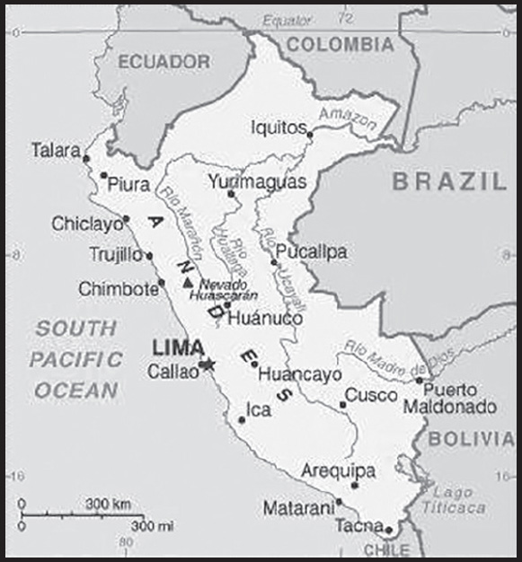
Location: Western South America, bordering the South Pacific Ocean, between Chile and Ecuador
Geographic coordinates: 10 00 S, 76 00 W
Map references: South America
Area: total: 1,285,216 sq km
land: 1,279,996 sq km
water: 5,220 sq km
comparison ranking: total 21
Area - comparative: almost twice the size of Texas; slightly smaller than Alaska
Land boundaries: total: 7,062 km
border countries (5): Bolivia 1,212 km; Brazil 2,659 km; Chile 168 km; Colombia 1,494 km; Ecuador 1,529 km
Coastline: 2,414 km
Maritime claims: territorial sea: 200 nm; note: the US does not recognize this claim
exclusive economic zone: 200 nm
continental shelf: 200 nm
Climate: varies from tropical in east to dry desert in west; temperate to frigid in Andes
Terrain: western coastal plain (costa), high and rugged Andes in center (sierra), eastern lowland jungle of Amazon Basin (selva)
Elevation: highest point: Nevado Huascaran 6,746 m
lowest point: Pacific Ocean 0 m
mean elevation: 1,555 m
Natural resources: copper, silver, gold, petroleum, timber, fish, iron ore, coal, phosphate, potash, hydropower, natural gas
Land use: agricultural land: 18.8% (2018 est.)
arable land: 3.1% (2018 est.)
permanent crops: 1.1% (2018 est.)
permanent pasture: 14.6% (2018 est.)
forest: 53% (2018 est.)
other: 28.2% (2018 est.)
Irrigated land: 25,800 sq km (2012)
Major lakes (area sq km): fresh water lake(s): Lago Titicaca (shared with Bolivia) - 8,030 sq km
Major rivers (by length in km): Amazon river source (shared with Brazil [m]) - 6,400 km
note – [s] after country name indicates river source; [m] after country name indicates river mouth
Major watersheds (area sq km): Atlantic Ocean drainage: Amazon (6,145,186 sq km)
Major aquifers: Amazon Basin
Population distribution: approximately one-third of the population resides along the desert coastal belt in the west, with a strong focus on the capital city of Lima; the Andean highlands, or sierra, which is strongly identified with the country’s Amerindian population, contains roughly half of the overall population; the eastern slopes of the Andes, and adjoining rainforest, are sparsely populated
Natural hazards: earthquakes, tsunamis, flooding, landslides, mild volcanic activity
volcanism: volcanic activity in the Andes Mountains; Ubinas (5,672 m), which last erupted in 2009, is the country’s most active volcano; other historically active volcanoes include El Misti, Huaynaputina, Sabancaya, and Yucamane; see note 2 under “Geography - note”
Geography - note: note 1: shares control of Lago Titicaca, world’s highest navigable lake, with Bolivia; a remote slope of Nevado Mismi, a 5,316 m peak, is the ultimate source of the Amazon River
note 2: Peru is one of the countries along the Ring of Fire, a belt of active volcanoes and earthquake epicenters bordering the Pacific Ocean; up to 90% of the world’s earthquakes and some 75% of the world’s volcanoes occur within the Ring of Fire
note 3: on 19 February 1600, Mount Huaynaputina in the southern Peruvian Andes erupted in the largest volcanic explosion in South America in historical times; intermittent eruptions lasted until 5 March 1600 and pumped an estimated 16 to 32 million metric tons of particulates into the atmosphere reducing the amount of sunlight reaching the earth’s surface and affecting weather worldwide; over the next two and a half years, millions died around the globe in famines from bitterly cold winters, cool summers, and the loss of crops and animals
note 4: the southern regions of Peru and the extreme northwestern part of Bolivia are considered to be the place of origin for the common potato
PEOPLE AND SOCIETY
Population: 32,440,172 (2023 est.)
comparison ranking: 46
Nationality: noun: Peruvian(s)
adjective: Peruvian
Ethnic groups: Mestizo (mixed Amerindian and White) 60.2%, Amerindian 25.8%, White 5.9%, African descent 3.6%, other (includes Chinese and Japanese descent) 1.2%, unspecified 3.3% (2017 est.)
Languages: Spanish (official) 82.9%, Quechua (official) 13.6%, Aymara (official) 1.6%, Ashaninka 0.3%, other native languages (includes a large number of minor Amazonian languages) 0.8%, other (includes foreign languages and sign language) 0.2%, none 0.1%, unspecified 0.7% (2017 est.)
major-language sample(s):
La Libreta Informativa del Mundo, la fuente indispensable de información básica. (Spanish)
Religions: Roman Catholic 60%, Christian 14.6% (includes Evangelical 11.1%, other 3.5%), other 0.3%, none 4%, unspecified 21.1% (2017 est.)
Demographic profile: Peru’s urban and coastal communities have benefited much more from recent economic growth than rural, Afro-Peruvian, indigenous, and poor populations of the Amazon and mountain regions. The poverty rate has dropped substantially during the last decade but remains stubbornly high at about 30% (more than 55% in rural areas). After remaining almost static for about a decade, Peru’s malnutrition rate began falling in 2005, when the government introduced a coordinated strategy focusing on hygiene, sanitation, and clean water. School enrollment has improved, but achievement scores reflect ongoing problems with educational quality. Many poor children temporarily or permanently drop out of school to help support their families. About a quarter to a third of Peruvian children aged 6 to 14 work, often putting in long hours at hazardous mining or construction sites.
Peru was a country of immigration in the 19th and early 20th centuries, but has become a country of emigration in the last few decades. Beginning in the 19th century, Peru brought in Asian contract laborers mainly to work on coastal plantations. Populations of Chinese and Japanese descent - among the largest in Latin America - are economically and culturally influential in Peru today. Peruvian emigration began rising in the 1980s due to an economic crisis and a violent internal conflict, but outflows have stabilized in the last few years as economic conditions have improved. Nonetheless, more than 2 million Peruvians have emigrated in the last decade, principally to the US, Spain, and Argentina.
Age structure: 0-14 years: 26.04% (male 4,311,243/female 4,136,849)
15-64 years: 65.94% (male 10,452,598/female 10,937,233)
65 years and over: 8.02% (2023 est.) (male 1,134,587/female 1,467,662)
Dependency ratios: total dependency ratio: 53
youth dependency ratio: 37.1
elderly dependency ratio: 13.1
potential support ratio: 7.9 (2021 est.)
Median age: total: 29.1 years (2020)
male: 28.3 years
female: 29.9 years
comparison ranking: total 137
Population growth rate: 0.5% (2023 est.)
comparison ranking: 152
Birth rate: 16.96 births/1,000 population (2023 est.)
comparison ranking: 92
Death rate: 11.04 deaths/1,000 population (2023 est.)
comparison ranking: 21
Net migration rate: -0.89 migrant(s)/1,000 population (2023 est.)
comparison ranking: 141
Population distribution: approximately one-third of the population resides along the desert coastal belt in the west, with a strong focus on the capital city of Lima; the Andean highlands, or sierra, which is strongly identified with the country’s Amerindian population, contains roughly half of the overall population; the eastern slopes of the Andes, and adjoining rainforest, are sparsely populated
Urbanization: urban population: 78.9% of total population (2023)
rate of urbanization: 1.33% annual rate of change (2020-25 est.)
Major urban areas - population: 11.204 million LIMA (capital), 959,000 Arequipa, 904,000 Trujillo (2023)
Sex ratio: at birth: 1.05 male(s)/female
0-14 years: 1.04 male(s)/female
15-64 years: 0.96 male(s)/female
65 years and over: 0.77 male(s)/female
total population: 0.96 male(s)/female (2023 est.)
Mother’s mean age at first birth: 21.9 years (2013 est.)
note: data represents median age at first birth among women 25-49
Maternal mortality ratio: 69 deaths/100,000 live births (2020 est.)
comparison ranking: 88
Infant mortality rate: total: 10.8 deaths/1,000 live births (2023 est.)
male: 11.89 deaths/1,000 live births
female: 9.65 deaths/1,000 live births
comparison ranking: total 131
Life expectancy at birth: total population: 68.94 years (2023 est.)
male: 65.38 years
female: 72.67 years
comparison ranking: total population 181
Total fertility rate: 2.18 children born/woman (2023 est.)
comparison ranking: 86
Gross reproduction rate: 1.06 (2023 est.)
Contraceptive prevalence rate: 77.4% (2020)
Drinking water source: improved: urban: 97.2% of population
rural: 82.4% of population
total: 94% of population
unimproved: urban: 2.8% of population
rural: 17.6% of population
total: 6% of population (2020 est.)
Current health expenditure: 6.3% of GDP (2020)
Physicians density: 1.37 physicians/1,000 population (2018)
Hospital bed density: 1.6 beds/1,000 population (2017)
Sanitation facility access: improved: urban: 93.6% of population
rural: 65.3% of population
total: 87.4% of population
unimproved: urban: 6.4% of population
rural: 34.7% of population
total: 12.6% of population (2020 est.)
Major infectious diseases: degree of risk: very high (2023)
food or waterborne diseases: bacterial diarrhea, hepatitis A, and typhoid fever
vectorborne diseases: dengue fever, malaria, and Bartonellosis (Oroya fever)
Obesity - adult prevalence rate: 19.7% (2016)
comparison ranking: 110
Alcohol consumption per capita: total: 5.74 liters of pure alcohol (2019 est.)
beer: 3.01 liters of pure alcohol (2019 est.)
wine: 0.46 liters of pure alcohol (2019 est.)
spirits: 2.26 liters of pure alcohol (2019 est.)
other alcohols: 0.01 liters of pure alcohol (2019 est.)
comparison ranking: total 76
Tobacco use: total: 8.1% (2020 est.)
male: 13.2% (2020 est.)
female: 3% (2020 est.)
comparison ranking: total 149
Children under the age of 5 years underweight: 2.1% (2021)
comparison ranking: 103
Currently married women (ages 15-49): 51.2% (2023 est.)
Child marriage: women married by age 15: 2%
women married by age 18: 14.1% (2020 est.)
Education expenditures: 4% of GDP (2021 est.)
comparison ranking: 114
Literacy: definition: age 15 and over can read and write
total population: 94.5%
male: 97%
female: 92% (2020)
School life expectancy (primary to tertiary education): total: 15 years
male: 15 years
female: 15 years (2017)
Youth unemployment rate (ages 15-24): total: 11.2% (2021 est.)
male: 9.2%
female: 13.2%
comparison ranking: total 144
ENVIRONMENT
Environment - current issues: deforestation (some the result of illegal logging); overgrazing leading to soil erosion; desertification; air pollution in Lima; pollution of rivers and coastal waters from municipal and mining wastes; overfishing
Environment - international agreements: party to: Antarctic-Environmental Protection, Antarctic-Marine Living Resources, Antarctic Treaty, Biodiversity, Climate Change, Climate Change-Kyoto Protocol, Climate Change-Paris Agreement, Desertification, Endangered Species, Hazardous Wastes, Marine Dumping-London Convention, Marine Dumping-London Protocol, Nuclear Test Ban, Ozone Layer Protection, Ship Pollution, Tropical Timber 2006, Wetlands, Whaling
signed, but not ratified: none of the selected agreements
Climate: varies from tropical in east to dry desert in west; temperate to frigid in Andes
Land use: agricultural land: 18.8% (2018 est.)
arable land: 3.1% (2018 est.)
permanent crops: 1.1% (2018 est.)
permanent pasture: 14.6% (2018 est.)
forest: 53% (2018 est.)
other: 28.2% (2018 est.)
Urbanization: urban population: 78.9% of total population (2023)
rate of urbanization: 1.33% annual rate of change (2020-25 est.)
Revenue from forest resources: 0.12% of GDP (2018 est.)
comparison ranking: 109
Revenue from coal: 0% of GDP (2018 est.)
comparison ranking: 145
Air pollutants: particulate matter emissions: 29.07 micrograms per cubic meter (2019 est.)
carbon dioxide emissions: 57.41 megatons (2016 est.)
methane emissions: 30.17 megatons (2020 est.)
Waste and recycling: municipal solid waste generated annually: 8,356,711 tons (2014 est.)
municipal solid waste recycled annually: 334,268 tons (2012 est.)
percent of municipal solid waste recycled: 4% (2012 est.)
Major lakes (area sq km): fresh water lake(s): Lago Titicaca (shared with Bolivia) - 8,030 sq km
Major rivers (by length in km): Amazon river source (shared with Brazil [m]) - 6,400 km
note – [s] after country name indicates river source; [m] after country name indicates river mouth
Major watersheds (area sq km): Atlantic Ocean drainage: Amazon (6,145,186 sq km)
Major aquifers: Amazon Basin
Total water withdrawal: municipal: 2.24 billion cubic meters (2020 est.)
industrial: 3.51 billion cubic meters (2020 est.)
agricultural: 32.8 billion cubic meters (2020 est.)
Total renewable water resources: 1.88 trillion cubic meters (2020 est.)
GOVERNMENT
Country name: conventional long form: Republic of Peru
conventional short form: Peru
local long form: República del Peru
local short form: Peru
etymology: exact meaning is obscure, but the name may derive from a native word “biru” meaning “river”
Government type: presidential republic
Capital: name: Lima
geographic coordinates: 12 03 S, 77 03 W
time difference: UTC-5 (same time as Washington, DC, during Standard Time)
etymology: the word “Lima” derives from the Spanish pronunciation of “Limaq,” the native name for the valley in which the city was founded in 1535; “limaq” means “talker” in coastal Quechua and referred to an oracle that was situated in the valley but which was eventually destroyed by the Spanish and replaced with a church
Administrative divisions: 25 regions (regiones, singular - region) and 1 province* (provincia); Amazonas, Ancash, Apurimac, Arequipa, Ayacucho, Cajamarca, Callao, Cusco, Huancavelica, Huanuco, Ica, Junin, La Libertad, Lambayeque, Lima, Lima*, Loreto, Madre de Dios, Moquegua, Pasco, Piura, Puno, San Martin, Tacna, Tumbes, Ucayali
note: Callao, the largest port in Peru, is also referred to as a constitutional province, the only province of the Callao region
Independence: 28 July 1821 (from Spain)
National holiday: Independence Day, 28-29 July (1821)
Constitution: history: several previous; latest promulgated 29 December 1993, enacted 31 December 1993
amendments: proposed by Congress, by the president of the republic with the approval of the Council of Ministers or by petition of at least 0.3% of voters; passage requires absolute majority approval by the Congress membership, followed by approval in a referendum; a referendum is not required if Congress approves the amendment by greater than two-thirds majority vote in each of two successive sessions; amended many times, last in 2021
Legal system: civil law system
International law organization participation: accepts compulsory ICJ jurisdiction with reservations; accepts ICCt jurisdiction
Citizenship: citizenship by birth: yes
citizenship by descent only: yes
dual citizenship recognized: yes
residency requirement for naturalization: 2 years
Suffrage: 18 years of age; universal and compulsory until the age of 70
Executive branch: chief of state: President Dina Ercilia BOLUARTE Zegarra (since 7 December 2022); first vice president (vacant); second vice president (vacant); note - the president is both chief of state and head of government
head of government: President Dina Ercilia BOLUARTE Zegarra (since 7 December 2022); first vice president (vacant); second vice president (vacant)
cabinet: Council of Ministers appointed by the president
elections/appointments: president directly elected by absolute majority popular vote in 2 rounds if needed for a 5-year term (eligible for nonconsecutive terms); election last held on 11 April 2021 with a runoff on 6 June 2021 (next to be held in April 2026)
election results:
2021: Jose Pedro CASTILLO Terrones elected president in second round; percent of vote in first round - Jose Pedro CASTILLO Terrones (PL) 18.9%, Keiko Sofia FUJIMORI Higuchi (FP) 13.4%, Rafael LOPEZ ALIAGA Cazorla (RP) 11.8%, Hernando DE SOTO Polar (Social Integration Party) 11.6%, Yonhy LESCANO Ancieta (AP) 9.1%, Veronika MENDOZA Frisch (JP) 7.9%, Cesar ACUNA Peralta (APP) 6%, George FORSYTH Sommer (VN) 5.7%, Daniel Belizario URRESTI Elera (PP) 5.6%, other 10%; percent of vote second round - Jose Pedro CASTILLO Terrones (PL) 50.1%, Keiko Sofia FUJIMORI Higuchi (FP) 49.9%
2016: Pedro Pablo KUCZYNSKI Godard elected president in second round; percent of vote in first round - Keiko FUJIMORI Higuchi (FP) 39.9%, Pedro Pablo KUCZYNSKI Godard (PPK) 21.1%, Veronika MENDOZA (FA) 18.7%, Alfredo BARNECHEA (AP) 7%, Alan GARCIA (APRA) 5.8%, other 7.5%; percent of vote in second round - Pedro Pablo KUCZYNSKI Godard 50.1%, Keiko FUJIMORI Higuchi 49.9%
note 1: First Vice President Dina Ercilia BOLUARTE Zegarra assumed the office of the president on 7 December 2022 after President Jose Pedro CASTILLO Terrones was impeached and arrested; BOLUARTE is the first woman to become president of Peru
note 2: Prime Minister Alberto OTAROLA Penaranda (since 21 December 2022) does not exercise executive power; this power rests with the president
Legislative branch: description: unicameral Congress of the Republic of Peru or Congreso de la Republica del Peru (130 seats; members directly elected in multi-seat constituencies by closed party-list proportional representation vote to serve single 5-year terms)
elections: last held on 11 April 2021 (next to be held in April 2026)
election results: percent of vote by party/coalition - NA; seats by party/coalition - Free Peru 32, Popular Force 24, AP 15, APP 15, Avanza Pais 10, Popular Renewal 9, Democratic Peru 7, We Are Peru 5, We Can Peru 5, JP 5, Purple Party 3; composition - men 78, women 52, percent of women 40%
Judicial branch: highest court(s): Supreme Court (consists of 16 judges and divided into civil, criminal, and constitutional-social sectors)
judge selection and term of office: justices proposed by the National Board of Justice (a 7-member independent body), nominated by the president, and confirmed by the Congress; justices can serve until mandatory retirement at age 70
subordinate courts: Court of Constitutional Guarantees; Superior Courts or Cortes Superiores; specialized civil, criminal, and mixed courts; 2 types of peace courts in which professional judges and selected members of the local communities preside
Political parties and leaders: Advance the Nation (Avanza Pais) [Aldo BORRERO Zeta]
Alliance for Progress (Alianza para el Progreso) or APP [Cesar ACUNA Peralta]
Broad Front (Frente Amplio) or FA [Marco ARANA]
Free Peru (Peru Libre) or PL [Vladimir CERRON Rojas]
Front for Hope (Frente Esperanza) [Fernando OLIVERA Vega]
National Victory (Victoria Nacional) or VN [George FORSYTH Sommer]
Popular Action (Accion Popular) or AP [Mesias GUEVARA Amasifuen]
Popular Force (Fuerza Popular) or FP [Keiko FUJIMORI Higuchi]
Popular Renewal (Renovacion Popular) or RP [Rafael LOPEZ ALIAGA]
Purple Party (Partido Morado) [Luis DURAN Rojo]
Social Integration Party (Avanza Pais - Partido de Integracion Social) [Aldo BORRERO]
Together For Peru (Juntos por el Peru) or JP [Robert SANCHEZ Palomino]
We Are Peru (Somos Peru) of SP [Patricia LI]
We Can Peru (Podemos Peru) or PP [Jose Leon LUNA Galvez]
International organization participation: APEC, BIS, CAN, CD, CELAC, EITI (compliant country), FAO, G-24, G-77, IADB, IAEA, IBRD, ICAO, ICC (NGOs), ICCt, ICRM, IDA, IFAD, IFC, IFRCS, IHO, ILO, IMF, IMO, IMSO, Interpol, IOC, IOM, IPU, ISO, ITSO, ITU, ITUC (NGOs), LAES, LAIA, Mercosur (associate), MIGA, MINUSTAH, MONUSCO, NAM, OAS, OPANAL, OPCW, Pacific Alliance, PCA, PROSUR, SICA (observer), UN, UNAMID, UNASUR, UNCTAD, UNESCO, UNHCR, UNIDO, Union Latina, UNISFA, UNMISS, UNOCI, UN Security Council (temporary), UNWTO, UPU, WCO, WFTU (NGOs), WHO, WIPO, WMO, WTO
Diplomatic representation in the US: chief of mission: Ambassador Gustavo Adolfo MEZA-CUADRA Velásquez (since 30 June 2023)
chancery: 1700 Massachusetts Avenue NW, Washington, DC 20036
telephone: [1] (202) 833-9860
FAX: [1] (202) 659-8124
email address and website:
Embassy of Peru in the United States - E-United States - Platform of the Peruvian State (www.gob.pe)
consulate(s) general: Atlanta, Boston, Chicago, Dallas, Denver, Hartford (CT), Houston, Los Angeles, Miami, New York, Paterson (NJ), San Francisco, Washington DC
Diplomatic representation from the US: chief of mission: Ambassador (vacant); Chargé d’Affaires John T. McNAMARA (since 8 September 2023)
embassy: Avenida La Encalada, Cuadra 17 s/n, Surco, Lima 33
mailing address: 3230 Lima Place, Washington DC 20521-3230
telephone: [51] (1) 618-2000
FAX: [51] (1) 618-2724
email address and website:
Flag description: three equal, vertical bands of red (hoist side), white, and red with the coat of arms centered in the white band; the coat of arms features a shield bearing a vicuna (representing fauna), a cinchona tree (the source of quinine, signifying flora), and a yellow cornucopia spilling out coins (denoting mineral wealth); red recalls blood shed for independence, white symbolizes peace
National symbol(s): vicuna (a camelid related to the llama); national colors: red, white
National anthem: name: “Himno Nacional del Peru” (National Anthem of Peru)
lyrics/music: Jose DE LA TORRE Ugarte/Jose Bernardo ALZEDO
note: adopted 1822; the song won a national anthem contest
National heritage: total World Heritage Sites: 13 (9 cultural, 2 natural, 2 mixed)
selected World Heritage Site locales: Cuzco (c); Machu Picchu (m); Chavin (c); Historic Lima (c); Huascarán National Park (n); Chan Chan (c); Manú National Park (n); Lines and Geoglyphs of Nazca (c); Rio Abiseo National Park (m); Historic Arequipa (c); Sacred City of Caral-Supe (c); Qhapaq Ñan/Andean Road System (c)
ECONOMY
Economic overview: upper middle-income South American economy; hit hard by political instability and COVID-19 but rebounding quickly; second-largest cocaine producer; current account balance improving; persistent income inequality; diversified exporter
Real GDP (purchasing power parity): $421.937 billion (2021 est.)
$372.245 billion (2020 est.)
$418.03 billion (2019 est.)
note: data are in 2017 dollars
comparison ranking: 47
Real GDP growth rate: 13.35% (2021 est.)
-10.95% (2020 est.)
2.24% (2019 est.)
comparison ranking: 13
Real GDP per capita: $12,500 (2021 est.)
$11,200 (2020 est.)
$12,700 (2019 est.)
note: data are in 2017 dollars
comparison ranking: 127
GDP (official exchange rate): $230.707 billion (2019 est.)
Inflation rate (consumer prices): 4.27% (2021 est.)
2% (2020 est.)
2.25% (2019 est.)
note: data are for metropolitan Lima, annual average
comparison ranking: 80
Credit ratings: Fitch rating: BBB+ (2013)
Moody’s rating: A3 (2014)
Standard & Poors rating: BBB+ (2013)
note: The year refers to the year in which the current credit rating was first obtained.
GDP - composition, by sector of origin: agriculture: 7.6% (2017 est.)
industry: 32.7% (2017 est.)
services: 59.9% (2017 est.)
comparison rankings: services 128; industry 63; agriculture 103
GDP - composition, by end use: household consumption: 64.9% (2017 est.)
government consumption: 11.7% (2017 est.)
investment in fixed capital: 21.7% (2017 est.)
investment in inventories: -0.2% (2017 est.)
exports of goods and services: 24% (2017 est.)
imports of goods and services: -22% (2017 est.)
Agricultural products: sugar cane, potatoes, rice, plantains, milk, poultry, maize, cassava, oil palm fruit, grapes
Industries: mining and refining of minerals; steel, metal fabrication; petroleum extraction and refining, natural gas and natural gas liquefaction; fishing and fish processing, cement, glass, textiles, clothing, food processing, beer, soft drinks, rubber, machinery, electrical machinery, chemicals, furniture
Industrial production growth rate: 16.44% (2021 est.)
comparison ranking: 10
Labor force: 18.352 million (2021 est.)
note: individuals older than 14 years of age
comparison ranking: 34
Labor force - by occupation: agriculture: 25.8%
industry: 17.4%
services: 56.8% (2011)
Unemployment rate: 4.83% (2021 est.)
7.18% (2020 est.)
3.38% (2019 est.)
note: data are for metropolitan Lima; widespread underemployment
comparison ranking: 155
Youth unemployment rate (ages 15-24): total: 11.2% (2021 est.)
male: 9.2%
female: 13.2%
comparison ranking: total 144
Population below poverty line: 20.2% (2019 est.)
Gini Index coefficient - distribution of family income: 43.8 (2020 est.)
comparison ranking: 31
Average household expenditures: on food: 26.3% of household expenditures (2018 est.)
on alcohol and tobacco: 2.4% of household expenditures (2018 est.)
Household income or consumption by percentage share: lowest 10%: 1.4%
highest 10%: 36.1% (2010 est.)
Budget: revenues: $45.983 billion (2019 est.)
expenditures: $49.134 billion (2019 est.)
Budget surplus (+) or deficit (-): -3.1% (of GDP) (2017 est.)
comparison ranking: 135
Public debt: 34.67% of GDP (2020 est.)
26.54% of GDP (2019 est.)
25.7% of GDP (2018 est.)
note: data cover general government debt, and includes debt instruments issued by government entities other than the treasury; the data exclude treasury debt held by foreign entities; the data include debt issued by subnational entities
comparison ranking: 156
Taxes and other revenues: 13.2% (of GDP) (2020 est.)
comparison ranking: 167
Fiscal year: calendar year
Current account balance: -$5.273 billion (2021 est.)
$2.398 billion (2020 est.)
-$1.68 billion (2019 est.)
comparison ranking: 189
Exports: $66.098 billion (2021 est.) note: data are in current year dollars
$45.624 billion (2020 est.) note: data are in current year dollars
$54.676 billion (2019 est.)
comparison ranking: 56
Exports - partners: China 29%, United States 12%, Canada 5%, South Korea 5%, Switzerland 5% (2019)
Exports - commodities: copper, gold, refined petroleum, zinc, fishmeal, tropical fruits, lead, iron, molybdenum (2019)
Imports: $58.611 billion (2021 est.) note: data are in current year dollars
$42.093 billion (2020 est.) note: data are in current year dollars
$51.778 billion (2019 est.)
comparison ranking: 59
Imports - partners: China 24%, United States 22%, Brazil 6% (2019)
Imports - commodities: refined petroleum, crude petroleum, cars, broadcasting equipment, delivery trucks (2019)
Reserves of foreign exchange and gold: $74.779 billion (31 December 2020 est.)
$67.711 billion (31 December 2019 est.)
$60.333 billion (31 December 2018 est.)
comparison ranking: 34
Debt - external: $81.333 billion (2019 est.)
$75.467 billion (2018 est.)
comparison ranking: 60
Exchange rates: nuevo sol (PEN) per US dollar -
Exchange rates: 3.881 (2021 est.)
3.495 (2020 est.)
3.337 (2019 est.)
3.287 (2018 est.)
3.26 (2017 est.)
ENERGY
Electricity access: population without electricity: (2020) less than 1 million
electrification - total population: 95.6% (2021)
electrification - urban areas: 98.9% (2021)
electrification - rural areas: 83.5% (2021)
Electricity: installed generating capacity: 15.34 million kW (2020 est.)
consumption: 49,121,370,000 kWh (2019 est.)
exports: 0 kWh (2019 est.)
imports: 60 million kWh (2019 est.)
transmission/distribution losses: 6.408 billion kWh (2019 est.)
comparison rankings: installed generating capacity 54; transmission/distribution losses 43; imports 112; exports 135; consumption 51
Electricity generation sources: fossil fuels: 38.5% of total installed capacity (2020 est.)
solar: 1.5% of total installed capacity (2020 est.)
wind: 3.5% of total installed capacity (2020 est.)
hydroelectricity: 55.4% of total installed capacity (2020 est.)
biomass and waste: 1.1% of total installed capacity (2020 est.)
Coal: production: 696,000 metric tons (2020 est.)
consumption: 396,000 metric tons (2020 est.)
exports: 252,000 metric tons (2020 est.)
imports: 262,000 metric tons (2020 est.)
proven reserves: 102 million metric tons (2019 est.)
Petroleum: total petroleum production: 122,500 bbl/day (2021 est.)
refined petroleum consumption: 265,500 bbl/day (2019 est.)
crude oil and lease condensate exports: 6,500 bbl/day (2018 est.)
crude oil and lease condensate imports: 112,900 bbl/day (2018 est.)
crude oil estimated reserves: 858.9 million barrels (2021 est.)
Refined petroleum products - production: 166,600 bbl/day (2015 est.)
comparison ranking: 57
Refined petroleum products - exports: 62,640 bbl/day (2015 est.)
comparison ranking: 49
Refined petroleum products - imports: 65,400 bbl/day (2015 est.)
comparison ranking: 71
Natural gas: production: 12,079,211,000 cubic meters (2020 est.)
consumption: 8,278,048,000 cubic meters (2019 est.)
exports: 5.446 billion cubic meters (2019 est.)
imports: 0 cubic meters (2021 est.)
proven reserves: 300.158 billion cubic meters (2021 est.)
Carbon dioxide emissions: 54.996 million metric tonnes of CO2 (2019 est.)
from coal and metallurgical coke: 1.171 million metric tonnes of CO2 (2019 est.)
from petroleum and other liquids: 35.119 million metric tonnes of CO2 (2019 est.)
from consumed natural gas: 18.706 million metric tonnes of CO2 (2019 est.)
comparison ranking: total emissions 55
Energy consumption per capita: 36.465 million Btu/person (2019 est.)
comparison ranking: 112
COMMUNICATIONS
Telephones - fixed lines: total subscriptions: 2,266,025 (2021 est.)
subscriptions per 100 inhabitants: 7 (2021 est.)
comparison ranking: total subscriptions 53
Telephones - mobile cellular: total subscriptions: 43,129,394 (2021 est.)
subscriptions per 100 inhabitants: 128 (2021 est.)
comparison ranking: total subscriptions 39
Telecommunication systems: general assessment: after suffering a sharp retraction in the number of subscriptions and revenue during 2020 due to the pandemic, Peru’s telecom sector managed to stage a small recovery in the first half of 2021; it will likely be two to three years before penetration rates return to the peak levels last seen in 2018; this is especially true given the overwhelming influence of mobile on Peru’s telecommunications market, which now commands almost 95% of all connections; Peru’s fixed-line teledensity continued its slow dropping below 7% at the end of 2021; investment in network infrastructure is mainly focused on rolling out fiber cable for fixed broadband services in (mainly) urban areas; fixed broadband services inched higher to reach 8.4% at the end of 2020, a positive result that reflected the shift to working from home during enforced lock downs at the start of the year; yet Peru has a relatively low level of computer use, and prices for fixed broadband services are among the highest in Latin America; the overwhelmingly preferred internet access platform will remain the smartphone, with a further 8.6% growth in the number of mobile broadband subscriptions expected in 2021 (2021)
domestic: fixed-line teledensity is 7 per 100 persons; mobile-cellular teledensity is 128 telephones per 100 persons (2021)
international: country code - 51; landing points for the SAM-1, IGW, American Movil-Telxius, SAC and PAN-AM submarine cable systems that provide links to parts of Central and South America, the Caribbean, and US; satellite earth stations - 2 Intelsat (Atlantic Ocean) (2019)
Broadcast media: 10 major TV networks of which only one, Television Nacional de Peru, is state owned; multi-channel cable TV services are available; in excess of 5,000 radio stations including a substantial number of indigenous language stations (2021)
Internet country code: .pe
Internet users: total: 24.14 million (2021 est.)
percent of population: 71% (2021 est.)
comparison ranking: total 35
Broadband - fixed subscriptions: total: 3.044 million (2020 est.)
subscriptions per 100 inhabitants: 9 (2020 est.)
comparison ranking: total 46
TRANSPORTATION
National air transport system: number of registered air carriers: 6 (2020)
inventory of registered aircraft operated by air carriers: 62
annual passenger traffic on registered air carriers: 17,758,527 (2018)
annual freight traffic on registered air carriers: 313.26 million (2018) mt-km
Civil aircraft registration country code prefix: OB
Airports: 191 (2021)
comparison ranking: total 31
Airports - with paved runways: 59
note: paved runways have a concrete or asphalt surface but not all have facilities for refueling, maintenance, or air traffic control; the length of a runway required for aircraft to safely operate depends on a number of factors including the type of aircraft, the takeoff weight (including passengers, cargo, and fuel), engine types, flap settings, landing speed, elevation of the airport, and average maximum daily air temperature; paved runways can reach a length of 5,000 m (16,000 ft.), but the “typical” length of a commercial airline runway is between 2,500-4,000 m (8,000-13,000 ft.)
Airports - with unpaved runways: 132
note: unpaved runways have a surface composition such as grass or packed earth and are most suited to the operation of light aircraft; unpaved runways are usually short, often less than 1,000 m (3,280 ft.) in length; airports with unpaved runways often lack facilities for refueling, maintenance, or air traffic control
Heliports: 5 (2021)
Pipelines: 786 km extra heavy crude, 1,526 km gas, 679 km liquid petroleum gas, 1,106 km oil, 15 km refined products (2022)
Railways: total: 1,854.4 km (2017)
standard gauge: 1,730.4 km (2014) 1.435-m gauge (34 km electrified)
narrow gauge: 124 km (2014) 0.914-m gauge
comparison ranking: total 75
Roadways: total: 18,699 km (2018)
paved: 18,699 km
note: includes 27,109 km of national roads (21,434 km paved), 247,505 km of departmental roads (3,623 km paved), and 113,857 km of local roads (1,858 km paved)
comparison ranking: total 117
Waterways: 8,808 km (2011) (8,600 km of navigable tributaries on the Amazon River system and 208 km on Lago Titicaca)
comparison ranking: 16
Merchant marine: total: 101 (2022)
by type: general cargo 1, oil tanker 8, other 92
comparison ranking: total 90
Ports and terminals: major seaport(s): Callao, Matarani, Paita
oil terminal(s): Conchan oil terminal, La Pampilla oil terminal
container port(s) (TEUs): Balboa (3,563,432); Callao (2,486,425) (2021)
river port(s): Iquitos, Pucallpa, Yurimaguas (Amazon)
MILITARY AND SECURITY
Military and security forces: Armed Forces of Peru (Fuerzas Armadas del Perú or FAP): Peruvian Army (Ejercito del Peru), Peruvian Navy (Marina de Guerra del Peru, MGP, includes naval infantry and Coast Guard), Air Force of Peru (Fuerza Aerea del Peru, FAP)
Ministry of the Interior (Ministerio del Interior): Peruvian National Police (Policía Nacional del Perú, PNP) (2023)
Military expenditures: 1.1% of GDP (2022 est.)
1.1% of GDP (2021 est.)
1.2% of GDP (2020 est.)
1.2% of GDP (2019 est.)
1.2% of GDP (2018 est.)
comparison ranking: 122
Military and security service personnel strengths: information varies; approximately 95,000 active-duty personnel (60,000 Army; 25,000 Navy, including about 4,000 naval infantry and 1,000 Coast Guard; 10,000 Air Force) (2023)
Military equipment inventories and acquisitions: the military’s inventory is a mix of mostly older equipment from a wide variety of suppliers, including Brazil, Europe, Russia/the former Soviet Union, and the US; in recent years, it has received some more modern weapons systems from more than a dozen countries with South Korea as the leading supplier (2023)
Military service age and obligation: 18-30 years of age for voluntary military service (12 months); no conscription (abolished in 1999) (2023)
note: as of 2019, women made up about 10% of the active duty military
Military deployments: 225 Central African Republic (MINUSCA) (2023)
Military - note: the Peruvian Armed Forces (FAP) are responsible for external security in addition to some domestic security responsibilities in designated emergency areas and in exceptional circumstances; key areas of focus include counterinsurgency, counternarcotics, disaster relief, and maritime security operations; the FAP trains regularly and participates in both bilateral and multinational exercises; it has contributed to UN missions since 1958 and has ties to regional militaries, particularly Colombia, as well as those of numerous other countries such as China, Russia, Spain, and the US; the FAP’s last external conflict was a brief border war with Ecuador in 1995; the FAP supported the police during anti-government protests in early 2023 and was accused of human rights violations
the Joint Command of the Armed Forces of Peru (Comando Conjunto de las Fuerzas Armadas del Perú or CCFFAA) has responsibility for the planning, preparation, coordination, and direction of the military’s operations; the CCFFAA has oversight over commands for air, air defense, cyber, maritime, and special operations, as well as five regional commands (Amazonas, central, north, south, and Ucayali) and a Special Command of the Valley of the Apurimac, Ene, and Mantaro rivers (CE-VRAEM); CE-VRAEM is responsible for combating the remnants of the Shining Path terrorist group (aka Sendero Luminoso; see Appendix T) and includes several thousand air, ground, naval, police, and special forces personnel; the FAP also provides aircraft, vehicles, and logistical support to the command
the Army was officially established in 1821 with the formation of the Peruvian Guard Legion; it has five regionally based divisions comprised of about 20 combat brigades, which include a mix of armored, artillery, jungle infantry, light infantry, mechanized cavalry, and special forces; the Army also has an aviation brigade and a multi-purpose support brigade designed in large part to provide assistance during natural disasters; the Navy, also established in 1821, includes the Coast Guard; it has undertaken efforts to modernize since the 2000s; the Navy’s warships include seven frigates, 15 corvettes and patrol ships, and six attack submarines; it also has a flotilla of river gunboats, plus naval aviation and a marine force comprised of amphibious infantry, light infantry, jungle infantry, and commandos; the Air Force, established in the 1920s, has several squadrons of French-, Russian-, and US-made fighters, multirole fighters, and fixed-wing ground attack aircraft, as well as attack helicopters (2023)
SPACE
Space agency/agencies: National Aerospace Research and Development Commission (Comisión Nacional de Investigación y Desarrollo Aeroespacia, CONIDA; established 1974); National Satellite Imagery Operations Center (Centro Nacional de Operaciones de Imágenes Satelitales, CONIS; established 2006) (2023)
Space launch site(s): Punta Lobos Rocket Range (Chilca, Huancayo; used by foreign partners for scientific sounding rocket launches (1970s-1990s; the US used the site for scientific launches in 1975 and 1983) (2023)
Space program overview: has a small space program focused on acquiring satellites, applying space applications such as data satellite imagery, and building small rockets; has built a small science/technology satellite; operates satellites and processes satellite imagery data; builds and launches sounding rockets with goal of developing a satellite/space launch vehicle (SLV); researching, developing, and acquiring technologies for manufacturing satellites and satellite payloads with a focus on remote sensing (RS) capabilities; member of Latin American and Caribbean Space Agency (ALCE); cooperates with a variety of foreign space agencies and industries, including those of Brazil, China, the European Space Agency and individual member states (particularly France and Germany), India, Russia, South Korea, Thailand, and the US, as well as signatories of the Latin American and Caribbean Space Agency (ALCE) (2023)
note: further details about the key activities, programs, and milestones of the country’s space program, as well as government spending estimates on the space sector, appear in Appendix S
TERRORISM
Terrorist group(s): Terrorist group(s): Shining Path (Sendero Luminoso)
note: details about the history, aims, leadership, organization, areas of operation, tactics, targets, weapons, size, and sources of support of the group(s) appear(s) in Appendix-T
TRANSNATIONAL ISSUES
Disputes - international: Peru-Bolivia: Peru rejects Bolivia’s claim to restore maritime access through a sovereign corridor through Chile along the Peruvian border
Peru-Brazil: none identified
Peru-Chile: Bolivia continues to press for a sovereign corridor to the Pacific Ocean; any concession Chile makes to Bolivia to grant them a sovereign corridor requires approval by Peru under the terms of their treaty; in January 2018, the International Court of Justice ruled that Chile is not legally obligated to negotiate a sovereign corridor to the Pacific Ocean with Bolivia
Peru-Chile-Ecuador: Chile and Ecuador rejected Peru’s November 2005 unilateral legislation to shift the axis of their joint treaty-defined maritime boundaries along the parallels of latitude to equidistance lines out to 200 nautical miles, which would give Peru 37,900 square kilometers of water
Peru-Colombia: organized illegal narcotics operations in Colombia have penetrated Peru’s shared border; problems also include cross border illegal migration, human trafficking, and contraband smuggling
Peru-Ecuador: in 1999, Tiwinza memorial park was created on lands that remains sovereign Peruvian territory, but Ecuador has the right to maintain and administer it in perpetuity
Refugees and internally displaced persons: refugees (country of origin): 1,518,102 (Venezuela) (economic and political crisis; includes Venezuelans who have claimed asylum, are recognized as refugees, or have received alternative legal stay) (2023)
IDPs: 73,000 (civil war from 1980-2000; most IDPs are indigenous peasants in Andean and Amazonian regions; as of 2011, no new information on the situation of these IDPs) (2022)
Illicit drugs: world’s second-largest producer of cocaine and coca (after Colombia), with approximately 84,400 hectares (ha) under cultivation in 2021; Peruvian cocaine is trafficked throughout South America for shipment to Europe, East Asia, Mexico, and the United States; major importer of precursor chemicals for cocaine production; growing domestic drug consumption problem; a major source of precursor or essential chemicals used in the production of illicit narcotics
PHILIPPINES
INTRODUCTION
Background: The Philippine Islands became a Spanish colony during the 16th century; they were ceded to the US in 1898 following the Spanish- American War. Led by Emilio AGUINALDO, the Filipinos conducted an insurgency against American rule from 1899-1902, although some fighting continued in outlying islands as late as 1913. In 1935 the Philippines became a self-governing commonwealth. Manuel QUEZON was elected president and was tasked with preparing the country for independence after a 10-year transition. In 1942 the islands fell under Japanese occupation during World War II, and US forces and Filipinos fought together during 1944-45 to regain control. On 4 July 1946 the Republic of the Philippines attained its independence. A 21-year rule by Ferdinand MARCOS ended in 1986, when a “people power” movement in Manila (“EDSA 1”) forced him into exile and installed Corazon AQUINO as president. Her presidency was hampered by several coup attempts that prevented a return to full political stability and economic development. Fidel RAMOS was elected president in 1992. His administration was marked by increased stability and by progress on economic reforms. In 1992, the US closed its last military bases on the islands. Joseph ESTRADA was elected president in 1998. He was succeeded by his vice-president, Gloria MACAPAGAL-ARROYO, in January 2001 after ESTRADA’s stormy impeachment trial on corruption charges broke down and another “people power” movement (“EDSA 2”) demanded his resignation. MACAPAGAL-ARROYO was elected to a six-year term as president in May 2004. Her presidency was marred by several corruption allegations, but the Philippine economy was one of the few to avoid contraction following the 2008 global financial crisis, expanding each year of her administration. Benigno AQUINO III was elected to a six-year term as president in May 2010 and was succeeded by Rodrigo DUTERTE in June 2016. During his six-year term, DUTERTE pursued a controversial drug war that garnered international criticism for alleged human rights abuses. Ferdinand MARCOS Jr., the son of MARCOS Sr., was elected president in May 2022 with the largest popular vote in a presidential election since his father’s ouster.
The Philippine Government faces threats from several groups, some of which are on the US Government’s Foreign Terrorist Organization list. Manila has waged a decades-long struggle against ethnic Moro insurgencies in the southern Philippines, which led to a peace accord with the Moro National Liberation Front and a separate agreement with a break away faction, the Moro Islamic Liberation Front. The decades-long Maoist-inspired New People’s Army insurgency also operates through much of the country. In 2017, Philippine armed forces battled an ISIS-East Asia siege in Marawi City, driving DUTERTE to declare martial law in the region. In 2019, DUTERTE shepherded a landmark peace deal with the Moro Islamic Liberation Front to establish a semi-autonomous region in the southern Philippines, the Bangsamoro Autonomous Region of Muslim Mindanao. The Philippines faces increased tension with China over disputed territorial and maritime claims in the South China Sea.
GEOGRAPHY
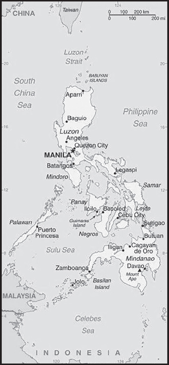
Location: Southeastern Asia, archipelago between the Philippine Sea and the South China Sea, east of Vietnam
Geographic coordinates: 13 00 N, 122 00 E
Map references: Southeast Asia
Area: total: 300,000 sq km
land: 298,170 sq km
water: 1,830 sq km
comparison ranking: total 74
Area - comparative: slightly less than twice the size of Georgia; slightly larger than Arizona
Land boundaries: total: 0 km
Coastline: 36,289 km
Maritime claims: territorial sea: irregular polygon extending up to 100 nm from coastline as defined by 1898 treaty; since late 1970s has also claimed polygonal-shaped area in South China Sea as wide as 285 nm
exclusive economic zone: 200 nm
continental shelf: to the depth of exploitation
Climate: tropical marine; northeast monsoon (November to April); southwest monsoon (May to October)
Terrain: mostly mountains with narrow to extensive coastal lowlands
Elevation: highest point: Mount Apo 2,954 m
lowest point: Philippine Sea 0 m
mean elevation: 442 m
Natural resources: timber, petroleum, nickel, cobalt, silver, gold, salt, copper
Land use: agricultural land: 41% (2018 est.)
arable land: 18.2% (2018 est.)
permanent crops: 17.8% (2018 est.)
permanent pasture: 5% (2018 est.)
forest: 25.9% (2018 est.)
other: 33.1% (2018 est.)
Irrigated land: 16,270 sq km (2012)
Major lakes (area sq km): salt water lake(s): Laguna de Bay - 890 sq km
Population distribution: population concentrated where good farmlands lie; highest concentrations are northwest and south-central Luzon, the southeastern extension of Luzon, and the islands of the Visayan Sea, particularly Cebu and Negros; Manila is home to one-eighth of the entire national population
Natural hazards: astride typhoon belt, usually affected by 15 and struck by five to six cyclonic storms each year; landslides; active volcanoes; destructive earthquakes; tsunamis
volcanism: significant volcanic activity; Taal (311 m), which has shown recent unrest and may erupt in the near future, has been deemed a Decade Volcano by the International Association of Volcanology and Chemistry of the Earth’s Interior, worthy of study due to its explosive history and close proximity to human populations; Mayon (2,462 m), the country’s most active volcano, erupted in 2009 forcing over 33,000 to be evacuated; other historically active volcanoes include Biliran, Babuyan Claro, Bulusan, Camiguin, Camiguin de Babuyanes, Didicas, Iraya, Jolo, Kanlaon, Makaturing, Musuan, Parker, Pinatubo, and Ragang; see note 2 under “Geography - note”
Geography - note: note 1: for decades, the Philippine archipelago was reported as having 7,107 islands; in 2016, the national mapping authority reported that hundreds of new islands had been discovered and increased the number of islands to 7,641 - though not all of the new islands have been verified; the country is favorably located in relation to many of Southeast Asia’s main water bodies: the South China Sea, Philippine Sea, Sulu Sea, Celebes Sea, and Luzon Strait
note 2: Philippines is one of the countries along the Ring of Fire, a belt of active volcanoes and earthquake epicenters bordering the Pacific Ocean; up to 90% of the world’s earthquakes and some 75% of the world’s volcanoes occur within the Ring of Fire
note 3: the Philippines sits astride the Pacific typhoon belt and an average of 9 typhoons make landfall on the islands each year - with about 5 of these being destructive; the country is the most exposed in the world to tropical storms
PEOPLE AND SOCIETY
Population: 116,434,200 (2023 est.)
comparison ranking: 13
Nationality: noun: Filipino(s)
adjective: Philippine
Ethnic groups: Tagalog 26%, Bisaya/Binisaya 14.3%, Ilocano 8%, Cebuano 8%, Illonggo 7.9%, Bikol/Bicol 6.5%, Waray 3.8%, Kapampangan 3%, Maguindanao 1.9%, Pangasinan 1.9%, other local ethnicities 18.5%, foreign ethnicities 0.2% (2020 est.)
Languages: Tagalog 39.9%, Bisaya/Binisaya 16%, Hiligaynon/Ilonggo 7.3%, Ilocano 7.1%, Cebuano 6.5%, Bikol/Bicol 3.9%, Waray 2.6%, Kapampangan 2.4%, Maguindanao 1.4%, Pangasinan/Panggalato 1.3%, other languages/dialects 11.2%, unspecified 0.4% (2020 est.)
major-language sample(s):
Ang World Factbook, ang mapagkukunan ng kailangang impormasyon. (Tagalog)
note: data represent percentage of households; unspecified Filipino (based on Tagalog) and English are official languagesTaga; eight major dialects - Tagalog, Cebuano, Ilocano, Hiligaynon or Ilonggo, Bicol, Waray, Pampango, and Pangasinan
Religions: Roman Catholic 78.8%, Muslim 6.4%, Iglesia ni Cristo 2.6%, other Christian 3.9%, other 8.2%, none/unspecified <0.1 (2020 est.)
Demographic profile: The Philippines is an ethnically diverse country that is in the early stages of demographic transition. Its fertility rate has dropped steadily since the 1950s. The decline was more rapid after the introduction of a national population program in the 1970s in large part due to the increased use of modern contraceptive methods, but fertility has decreased more slowly in recent years. The country’s total fertility rate (TFR) – the average number of births per woman – dropped below 5 in the 1980s, below 4 in the 1990s, and below 3 in the 2010s. TFR continues to be above replacement level at 2.9 and even higher among the poor, rural residents, and the less-educated. Significant reasons for elevated TFR are the desire for more than two children, in part because children are a means of financial assistance and security for parents as they age, particularly among the poor.
The Philippines are the source of one of the world’s largest emigrant populations, much of which consists of legal temporary workers known as Overseas Foreign Workers or OFWs. As of 2019, there were 2.2 million OFWs. They work in a wide array of fields, most frequently in services (such as caregivers and domestic work), skilled trades, and construction but also in professional fields, including nursing and engineering. OFWs most often migrate to Middle Eastern countries, but other popular destinations include Hong Kong, China, and Singapore, as well as employment on ships. Filipino seafarers make up 35-40% of the world’s seafarers, as of 2014. Women OFWs, who work primarily in domestic services and entertainment, have outnumbered men since 1992.
Migration and remittances have been a feature of Philippine culture for decades. The government has encouraged and facilitated emigration, regulating recruitment agencies and adopting legislation to protect the rights of migrant workers. Filipinos began emigrating to the US and Hawaii early in the 20th century. In 1934, US legislation limited Filipinos to 50 visas per year except during labor shortages, causing emigration to plummet. It was not until the 1960s, when the US and other destination countries – Canada, Australia, and New Zealand – loosened their immigration policies, that Filipino emigration expanded and diversified. The government implemented an overseas employment program in the 1970s, promoting Filipino labor to Gulf countries needing more workers for their oil industries. Filipino emigration increased rapidly. The government had intended for international migration to be temporary, but a lack of jobs and poor wages domestically, the ongoing demand for workers in the Gulf countries, and new labor markets in Asia continue to spur Philippine emigration.
Age structure: 0-14 years: 30.49% (male 18,133,279/female 17,366,394)
15-64 years: 64.06% (male 37,667,819/female 36,923,236)
65 years and over: 5.45% (2023 est.) (male 2,516,561/female 3,826,911)
Dependency ratios: total dependency ratio: 56.2
youth dependency ratio: 47.8
elderly dependency ratio: 8.3
potential support ratio: 12 (2021 est.)
Median age: total: 24.1 years (2020)
male: 23.6 years
female: 24.6 years
comparison ranking: total 167
Population growth rate: 1.58% (2023 est.)
comparison ranking: 61
Birth rate: 22.17 births/1,000 population (2023 est.)
comparison ranking: 55
Death rate: 6.32 deaths/1,000 population (2023 est.)
comparison ranking: 143
Net migration rate: -0.04 migrant(s)/1,000 population (2023 est.)
comparison ranking: 99
Population distribution: population concentrated where good farmlands lie; highest concentrations are northwest and south-central Luzon, the southeastern extension of Luzon, and the islands of the Visayan Sea, particularly Cebu and Negros; Manila is home to one-eighth of the entire national population
Urbanization: urban population: 48.3% of total population (2023)
rate of urbanization: 2.04% annual rate of change (2020-25 est.)
Major urban areas - population: 14.667 million MANILA (capital), 1.949 million Davao, 1.025 million Cebu City, 931,000 Zamboanga, 960,000 Antipolo, 803,000 Cagayan de Oro City, 803,000 Dasmarinas (2023)
Sex ratio: at birth: 1.05 male(s)/female
0-14 years: 1.04 male(s)/female
15-64 years: 1.02 male(s)/female
65 years and over: 0.66 male(s)/female
total population: 1 male(s)/female (2023 est.)
Mother’s mean age at first birth: 23.6 years (2022 est.)
note: data represents median age at first birth among women 25-49
Maternal mortality ratio: 78 deaths/100,000 live births (2020 est.)
comparison ranking: 75
Infant mortality rate: total: 22.14 deaths/1,000 live births (2023 est.)
male: 24.43 deaths/1,000 live births
female: 19.73 deaths/1,000 live births
comparison ranking: total 73
Life expectancy at birth: total population: 70.48 years (2023 est.)
male: 66.97 years
female: 74.15 years
comparison ranking: total population 169
Total fertility rate: 2.77 children born/woman (2023 est.)
comparison ranking: 54
Gross reproduction rate: 1.35 (2023 est.)
Contraceptive prevalence rate: 54.1% (2017)
Drinking water source: improved: urban: 99.1% of population
rural: 95% of population
total: 97% of population
unimproved: urban: 0.9% of population
rural: 5% of population
total: 3% of population (2020 est.)
Current health expenditure: 5.1% of GDP (2020)
Physicians density: 0.77 physicians/1,000 population (2020)
Hospital bed density: 1 beds/1,000 population (2014)
Sanitation facility access: improved: urban: 96% of population
rural: 91% of population
total: 93.4% of population
unimproved: urban: 4% of population
rural: 9% of population
total: 6.6% of population (2020 est.)
Major infectious diseases: degree of risk: high (2023)
food or waterborne diseases: bacterial diarrhea, hepatitis A, and typhoid fever
vectorborne diseases: dengue fever and malaria
water contact diseases: leptospirosis
Obesity - adult prevalence rate: 6.4% (2016)
comparison ranking: 167
Alcohol consumption per capita: total: 4.85 liters of pure alcohol (2019 est.)
beer: 1.47 liters of pure alcohol (2019 est.)
wine: 0.03 liters of pure alcohol (2019 est.)
spirits: 3.34 liters of pure alcohol (2019 est.)
other alcohols: 0.01 liters of pure alcohol (2019 est.)
comparison ranking: total 84
Tobacco use: total: 22.9% (2020 est.)
male: 39.3% (2020 est.)
female: 6.5% (2020 est.)
comparison ranking: total 67
Children under the age of 5 years underweight: 19.1% (2018)
comparison ranking: 17
Currently married women (ages 15-49): 59.3% (2023 est.)
Child marriage: women married by age 15: 2.2%
women married by age 18: 16.5% (2017 est.)
Education expenditures: 3.7% of GDP (2020 est.)
comparison ranking: 129
Literacy: definition: age 15 and over can read and write
total population: 96.3%
male: 95.7%
female: 96.9% (2019)
School life expectancy (primary to tertiary education): total: 13 years
male: 13 years
female: 13 years (2020)
Youth unemployment rate (ages 15-24): total: 7.3% (2021 est.)
male: 6.3%
female: 9%
comparison ranking: total 175
People - note: one of only two predominantly Christian nations in Southeast Asia, the other being Timor-Leste
ENVIRONMENT
Environment - current issues: uncontrolled deforestation especially in watershed areas; illegal mining and logging; soil erosion; air and water pollution in major urban centers; coral reef degradation; increasing pollution of coastal mangrove swamps that are important fish breeding grounds; coastal erosion; dynamite fishing; wildlife extinction
Environment - international agreements: party to: Biodiversity, Climate Change, Climate Change-Kyoto Protocol, Climate Change-Paris Agreement, Comprehensive Nuclear Test Ban, Desertification, Endangered Species, Hazardous Wastes, Law of the Sea, Marine Dumping-London Convention, Marine Dumping-London Protocol, Nuclear Test Ban, Ozone Layer Protection, Ship Pollution, Tropical Timber 2006, Wetlands
signed, but not ratified: none of the selected agreements
Climate: tropical marine; northeast monsoon (November to April); southwest monsoon (May to October)
Land use: agricultural land: 41% (2018 est.)
arable land: 18.2% (2018 est.)
permanent crops: 17.8% (2018 est.)
permanent pasture: 5% (2018 est.)
forest: 25.9% (2018 est.)
other: 33.1% (2018 est.)
Urbanization: urban population: 48.3% of total population (2023)
rate of urbanization: 2.04% annual rate of change (2020-25 est.)
Revenue from forest resources: 0.18% of GDP (2018 est.)
comparison ranking: 96
Revenue from coal: 0.07% of GDP (2018 est.)
comparison ranking: 28
Air pollutants: particulate matter emissions: 22.45 micrograms per cubic meter (2019 est.)
carbon dioxide emissions: 122.29 megatons (2016 est.)
methane emissions: 51.32 megatons (2020 est.)
Waste and recycling: municipal solid waste generated annually: 14,631,923 tons (2016 est.)
municipal solid waste recycled annually: 4,096,938 tons (2014 est.)
percent of municipal solid waste recycled: 28% (2014 est.)
Major lakes (area sq km): salt water lake(s): Laguna de Bay - 890 sq km
Total water withdrawal: municipal: 8.16 billion cubic meters (2020 est.)
industrial: 9.88 billion cubic meters (2020 est.)
agricultural: 67.83 billion cubic meters (2020 est.)
Total renewable water resources: 479 billion cubic meters (2020 est.)
GOVERNMENT
Country name: conventional long form: Republic of the Philippines
conventional short form: Philippines
local long form: Republika ng Pilipinas
local short form: Pilipinas
etymology: named in honor of King PHILLIP II of Spain by Spanish explorer Ruy LOPEZ de VILLALOBOS, who visited some of the islands in 1543
Government type: presidential republic
Capital: name: Manila
geographic coordinates: 14 36 N, 120 58 E
time difference: UTC+8 (13 hours ahead of Washington, DC, during Standard Time)
etymology: derives from the Tagalog “may-nila” meaning “where there is indigo” and refers to the presence of indigoyielding plants growing in the area surrounding the original settlement
Administrative divisions: 81 provinces and 38 chartered cities
provinces: Abra, Agusan del Norte, Agusan del Sur, Aklan, Albay, Antique, Apayao, Aurora, Basilan, Bataan, Batanes, Batangas, Biliran, Benguet, Bohol, Bukidnon, Bulacan, Cagayan, Camarines Norte, Camarines Sur, Camiguin, Capiz, Catanduanes, Cavite, Cebu, Cotabato, Davao del Norte, Davao del Sur, Davao de Oro, Davao Occidental, Davao Oriental, Dinagat Islands, Eastern Samar, Guimaras, Ifugao, Ilocos Norte, Ilocos Sur, Iloilo, Isabela, Kalinga, Laguna, Lanao del Norte, Lanao del Sur, La Union, Leyte, Maguindanao, Marinduque, Masbate, Mindoro Occidental, Mindoro Oriental, Misamis Occidental, Misamis Oriental, Mountain, Negros Occidental, Negros Oriental, Northern Samar, Nueva Ecija, Nueva Vizcaya, Palawan, Pampanga, Pangasinan, Quezon, Quirino, Rizal, Romblon, Samar, Sarangani, Siquijor, Sorsogon, South Cotabato, Southern Leyte, Sultan Kudarat, Sulu, Surigao del Norte, Surigao del Sur, Tarlac, Tawi-Tawi, Zambales, Zamboanga del Norte, Zamboanga del Sur, Zamboanga Sibugay;
chartered cities: Angeles, Bacolod, Baguio, Butuan, Cagayan de Oro, Caloocan, Cebu, Cotabato, Dagupan, Davao, General Santos, Iligan, Iloilo, Lapu-Lapu, Las Pinas, Lucena, Makati, Malabon, Mandaluyong, Mandaue, Manila, Marikina, Muntinlupa, Naga, Navotas, Olongapo, Ormoc, Paranaque, Pasay, Pasig, Puerto Princesa, Quezon, San Juan, Santiago, Tacloban, Taguig, Valenzuela, Zamboanga
Independence: 4 July 1946 (from the US)
National holiday: Independence Day, 12 June (1898); note - 12 June 1898 was date of declaration of independence from Spain; 4 July 1946 was date of independence from the US
Constitution: history: several previous; latest ratified 2 February 1987, effective 11 February 1987
amendments: proposed by Congress if supported by three fourths of the membership, by a constitutional convention called by Congress, or by public petition; passage by either of the three proposal methods requires a majority vote in a national referendum; note - the constitution has not been amended since its enactment in 1987
Legal system: mixed legal system of civil, common, Islamic (sharia), and customary law
International law organization participation: accepts compulsory ICJ jurisdiction with reservations; withdrew from the ICCt in March 2019
Citizenship: citizenship by birth: no
citizenship by descent only: at least one parent must be a citizen of the Philippines
dual citizenship recognized: no
residency requirement for naturalization: 10 years
Suffrage: 18 years of age; universal
Executive branch: chief of state: President Ferdinand “BongBong” MARCOS, Jr. (since 30 June 2022); Vice President Sara DUTERTE-Carpio (since 30 June 2022); note - the president is both chief of state and head of government
head of government: President Ferdinand “BongBong” MARCOS, Jr. (since 30 June 2022); Vice President Sara DUTERTE-Carpio (since 30 June 2022)
cabinet: Cabinet appointed by the president with the consent of the Commission of Appointments, an independent body of 25 Congressional members including the Senate president (ex officio chairman), appointed by the president
elections/appointments: president and vice president directly elected on separate ballots by simple majority popular vote for a single 6-year term; election last held on 9 May 2022 (next to be held on 9 May 2028)
election results:
2022: Ferdinand MARCOS, Jr. elected president; percent of vote - Ferdinand MARCOS, Jr. (PFP) 58.7%, Leni ROBREDO (independent) 27.9%, Manny PACQUIAO (PROMDI) 6.8%, other 6.6%; Sara DUTERTE-Carpio elected vice president; percent of vote Sara DUTERTE-Carpio (Lakas-CMD) 61.5%, Francis PANGILINAN (LP) 17.8%, Tito SOTTO 15.8%, other 4.9%
2016: Rodrigo DUTERTE elected president; percent of vote - Rodrigo DUTERTE (PDP-Laban) 39%, Manuel “Mar” ROXAS (LP) 23.5%, Grace POE (independent) 21.4%, Jejomar BINAY (UNA) 12.7%, Miriam Defensor SANTIAGO (PRP) 3.4%; Leni ROBREDO elected vice president; percent of vote Leni ROBREDO (LP) 35.1%, Bongbong MARCOS (independent) 34.5%, Alan CAYETANO 14.4%, Francis ESCUDERO (independent) 12%, other 4%
Legislative branch: description: bicameral Congress or Kongreso consists of:
Senate or Senado (24 seats; members directly elected in multi-seat constituencies by majority vote; members serve 6-year terms with one-half of the membership renewed every 3 years)
House of Representatives or Kapulungan Ng Mga Kinatawan (316 seats; 253 members directly elected in single-seat constituencies by simple majority vote and 63 representing minorities directly elected by party-list proportional representation vote; members serve 3-year terms)
elections:
Senate - elections last held on 9 May 2022 (next to be held in May 2025)
House of Representatives - elections last held on 9 May 2022 (next to be held in May 2025)
election results:
Senate - percent of vote by party - NA; seats by party - NPC 5, PDP-Laban 5, NP 4, other 5, independent 5; composition - men 17, women 7, percent of women 29%
House of Representatives - percent of vote by party - PDP-Laban 22.7%, NP 13.7%, NUP 12.6%, NPC 11.7%, Lakas- CMD 9.4%, LP 3.8%, HNP 2.5%, other 19.6% independent 4%; seats by party - PDP-Laban 66, NP, NPC 35, NUP 33, Lakas-CMD 26, LP 10, HNP 6, other 35, independent 6, party-list 63; composition - men 193, women 123, percent of women 38.9%; note - total Congress percent of women 38.2%
Judicial branch: highest court(s): Supreme Court (consists of a chief justice and 14 associate justices)
judge selection and term of office: justices are appointed by the president on the recommendation of the Judicial and Bar Council, a constitutionally created, 6-member body that recommends Supreme Court nominees; justices serve until age 70
subordinate courts: Court of Appeals; Sandiganbayan (special court for corruption cases of government officials); Court of Tax Appeals; regional, metropolitan, and municipal trial courts; sharia courts
Political parties and leaders: Democratic Action (Aksyon Demokratiko) [Ernesto RAMEL, Jr]
Alliance for Change (Hugpong ng Pagbabago or HNP) [Claude BAUTISTA]
Lakas ng EDSA-Christian Muslim Democrats or Lakas-CMD [Sara DUTERTE-CARPIO]
Liberal Party or LP [Francis PANGILINAN]
Nacionalista Party or NP [Manuel “Manny” VILLAR]
Nationalist People’s Coalition or NPC [Mark COJUANGCO]
National Unity Party or NUP [Ronaldo V. PUNO]
Partido Demokratiko Pilipino-Lakas ng Bayan or PDP-Laban [Rodrigo DUTERTE]
Partido Federal ng Pilipinas or PFP [Ferdinand MARCOS, Jr.]
Progressive Movement for the Devolution of Initiatives or PROMDI [Mariano “Mimo” OSMENA]
International organization participation: ADB, APEC, ARF, ASEAN, BIS, CD, CICA (observer), CP, EAS, FAO, G-24, G-77, IAEA, IBRD, ICAO, ICC (national committees), ICCt, ICRM, IDA, IFAD, IFC, IFRCS, IHO, ILO, IMF, IMO, IMSO, Interpol, IOC, IOM, IPU, ISO, ITSO, ITU, ITUC (NGOs), MIGA, MINUSTAH, NAM, OAS (observer), OPCW, PCA, PIF (partner), UN, UNCTAD, UNESCO, UNHCR, UNIDO, Union Latina, UNMIL, UNMOGIP, UNOCI, UNWTO, UPU, WCO, WFTU (NGOs), WHO, WIPO, WMO, WTO
Diplomatic representation in the US: chief of mission: Ambassador Jose Manuel del Gallego ROMUALDEZ (since 29 November 2017)
chancery: 1600 Massachusetts Avenue NW, Washington, DC 20036
telephone: [1] (202) 467-9300
FAX: [1] (202) 328-7614
email address and website:
info@phembassy-us.org; consular@phembassy-us.org
The Embassy of the Republic of the Philippines in Washington D.C. (philippineembassy-dc.org)
consulate(s) general: Chicago, Honolulu, Los Angeles, New York, Saipan (Northern Mariana Islands), San Francisco, Tamuning (Guam)
Diplomatic representation from the US: chief of mission: Ambassador MaryKay Loss CARLSON (since 22 July 2022)
embassy: 1201 Roxas Boulevard, Manila 1000
mailing address: 8600 Manila Place, Washington DC 20521-8600
telephone: [63] (2) 5301-2000
FAX: [63] (2) 5301-2017
email address and website:
Flag description: two equal horizontal bands of blue (top) and red; a white equilateral triangle is based on the hoist side; the center of the triangle displays a yellow sun with eight primary rays; each corner of the triangle contains a small, yellow, five-pointed star; blue stands for peace and justice, red symbolizes courage, the white equal-sided triangle represents equality; the rays recall the first eight provinces that sought independence from Spain, while the stars represent the three major geographical divisions of the country: Luzon, Visayas, and Mindanao; the design of the flag dates to 1897
note: in wartime the flag is flown upside down with the red band at the top
National symbol(s): three stars and sun, Philippine eagle; national colors: red, white, blue, yellow
Coat of Arms of the Philippines: National anthem
name: “Lupang Hinirang” (Chosen Land)
lyrics/music: Jose PALMA (revised by Felipe PADILLA de Leon)/Julian FELIPE
note: music adopted 1898, original Spanish lyrics adopted 1899, Filipino (Tagalog) lyrics adopted 1956; although the original lyrics were written in Spanish, later English and Filipino versions were created; today, only the Filipino version is used
National heritage: total World Heritage Sites: 6 (3 cultural, 3 natural)
selected World Heritage Site locales: Baroque Churches of the Philippines (c); Tubbataha Reefs Natural Park (n); Rice Terraces of the Philippine Cordilleras (c); Historic Vigan (c); Puerto-Princesa Subterranean River National Park (n); Mount Hamiguitan Range Wildlife Sanctuary (n)
ECONOMY
Economic overview: diversified, growing East Asian economy; major semiconductor, ship-building, and electronics exporter; significant remittances; COVID-19 hit consumption and investments hard; regional tensions with China; major geothermal energy user
Real GDP (purchasing power parity): $921.826 billion (2021 est.)
$872.09 billion (2020 est.)
$963.83 billion (2019 est.)
note: data are in 2017 dollars
comparison ranking: 30
Real GDP growth rate: 5.7% (2021 est.)
-9.52% (2020 est.)
6.12% (2019 est.)
comparison ranking: 78
Real GDP per capita: $8,100 (2021 est.)
$7,800 (2020 est.)
$8,700 (2019 est.)
note: data are in 2017 dollars
comparison ranking: 155
GDP (official exchange rate): $377.205 billion (2019 est.)
Inflation rate (consumer prices): 3.93% (2021 est.)
2.39% (2020 est.)
2.39% (2019 est.)
comparison ranking: 97
Credit ratings: Fitch rating: BBB (2017)
Moody’s rating: Baa2 (2014)
Standard & Poors rating: BBB+ (2019)
note: The year refers to the year in which the current credit rating was first obtained.
GDP - composition, by sector of origin: agriculture: 9.6% (2017 est.)
industry: 30.6% (2017 est.)
services: 59.8% (2017 est.)
comparison rankings: services 130; industry 74; agriculture 93
GDP - composition, by end use: household consumption: 73.5% (2017 est.)
government consumption: 11.3% (2017 est.)
investment in fixed capital: 25.1% (2017 est.)
investment in inventories: 0.1% (2017 est.)
exports of goods and services: 31% (2017 est.)
imports of goods and services: -40.9% (2017 est.)
Agricultural products: sugar cane, rice, coconuts, maize, bananas, vegetables, tropical fruit, plantains, pineapples, cassava
Industries: semiconductors and electronics assembly, business process outsourcing, food and beverage manufacturing, construction, electric/gas/water supply, chemical products, radio/television/communications equipment and apparatus, petroleum and fuel, textile and garments, non-metallic minerals, basic metal industries, transport equipment
Industrial production growth rate: 8.49% (2021 est.)
comparison ranking: 46
Labor force: 44.242 million (2021 est.)
comparison ranking: 14
Labor force - by occupation: agriculture: 25.4%
industry: 18.3%
services: 56.3% (2017 est.)
Unemployment rate: 2.41% (2021 est.)
2.52% (2020 est.)
2.24% (2019 est.)
comparison ranking: 205
Youth unemployment rate (ages 15-24): total: 7.3% (2021 est.)
male: 6.3%
female: 9%
comparison ranking: total 175
Population below poverty line: 16.7% (2018 est.)
Gini Index coefficient - distribution of family income: 42.3 (2018 est.)
comparison ranking: 40
Average household expenditures: on food: 42% of household expenditures (2018 est.)
on alcohol and tobacco: 1.4% of household expenditures (2018 est.)
Household income or consumption by percentage share: lowest 10%: 3.2%
highest 10%: 29.5% (2015 est.)
Budget: revenues: $71.173 billion (2020 est.)
expenditures: $90.953 billion (2020 est.)
Budget surplus (+) or deficit (-): -2.2% (of GDP) (2017 est.)
comparison ranking: 108
Public debt: 39.9% of GDP (2017 est.)
39% of GDP (2016 est.)
comparison ranking: 135
Taxes and other revenues: 13.95% (of GDP) (2020 est.)
comparison ranking: 162
Fiscal year: calendar year
Current account balance: -$6.009 billion (2021 est.)
$11.578 billion (2020 est.)
-$3.047 billion (2019 est.)
comparison ranking: 192
Exports: $87.79 billion (2021 est.) note: data are in current year dollars
$80.034 billion (2020 est.) note: data are in current year dollars
$94.741 billion (2019 est.) note: data are in current year dollars
comparison ranking: 47
Exports - partners: China 16%, United States 14%, Japan 12%, Hong Kong 12%, Singapore 7% (2021)
Exports - commodities: integrated circuits, office machinery/parts, insulated wiring, transformers, semiconductors (2021)
Imports: $126.508 billion (2021 est.) note: data are in current year dollars
$99.943 billion (2020 est.) note: data are in current year dollars
$131.013 billion (2019 est.) note: data are in current year dollars
comparison ranking: 39
Imports - partners: China 29%, Japan 8%, South Korea 7%, United States 6%, Singapore 6%, Indonesia 6%, Thailand 5%, Taiwan 5% (2019)
Imports - commodities: integrated circuits, refined petroleum, cars, crude petroleum, broadcasting equipment (2019)
Reserves of foreign exchange and gold: $108.755 billion (31 December 2021 est.)
$109.99 billion (31 December 2020 est.)
$89.515 billion (31 December 2019 est.)
comparison ranking: 28
Debt - external: $81.995 billion (2019 est.)
$75.192 billion (2018 est.)
comparison ranking: 59
Exchange rates: Philippine pesos (PHP) per US dollar -
Exchange rates: 49.255 (2021 est.)
49.624 (2020 est.)
51.796 (2019 est.)
52.661 (2018 est.)
50.404 (2017 est.)
ENERGY
Electricity access: population without electricity: 3 million (2020)
electrification - total population: 97.4% (2021)
electrification - urban areas: 98.6% (2021)
electrification - rural areas: 96.4% (2021)
Electricity: installed generating capacity: 27.885 million kW (2020 est.)
consumption: 90,926,990,000 kWh (2019 est.)
exports: 0 kWh (2020 est.)
imports: 0 kWh (2020 est.)
transmission/distribution losses: 9.994 billion kWh (2019 est.)
comparison rankings: imports 209; exports 209; installed generating capacity 38; transmission/distribution losses 32; consumption 35
Electricity generation sources: fossil fuels: 77.6% of total installed capacity (2020 est.)
solar: 1.3% of total installed capacity (2020 est.)
wind: 1.1% of total installed capacity (2020 est.)
hydroelectricity: 8% of total installed capacity (2020 est.)
geothermal: 11% of total installed capacity (2020 est.)
biomass and waste: 1.1% of total installed capacity (2020 est.)
Coal: production: 13.752 million metric tons (2020 est.)
consumption: 32.855 million metric tons (2020 est.)
exports: 7.554 million metric tons (2020 est.)
imports: 28.358 million metric tons (2020 est.)
proven reserves: 361 million metric tons (2019 est.)
Petroleum: total petroleum production: 10,300 bbl/day (2021 est.)
refined petroleum consumption: 527,400 bbl/day (2019 est.)
crude oil and lease condensate exports: 12,400 bbl/day (2018 est.)
crude oil and lease condensate imports: 232,500 bbl/day (2018 est.)
crude oil estimated reserves: 138.5 million barrels (2021 est.)
Refined petroleum products - production: 215,500 bbl/day (2015 est.)
comparison ranking: 50
Refined petroleum products - exports: 26,710 bbl/day (2015 est.)
comparison ranking: 65
Refined petroleum products - imports: 211,400 bbl/day (2015 est.)
comparison ranking: 33
Natural gas: production: 3,632,507,000 cubic meters (2019 est.)
consumption: 3,632,507,000 cubic meters (2019 est.)
exports: 0 cubic meters (2021 est.)
imports: 0 cubic meters (2021 est.)
proven reserves: 98.542 billion cubic meters (2021 est.)
Carbon dioxide emissions: 142.282 million metric tonnes of CO2 (2019 est.)
from coal and metallurgical coke: 70.82 million metric tonnes of CO2 (2019 est.)
from petroleum and other liquids: 64.418 million metric tonnes of CO2 (2019 est.)
from consumed natural gas: 7.044 million metric tonnes of CO2 (2019 est.)
comparison ranking: total emissions 36
Energy consumption per capita: 19.261 million Btu/person (2019 est.)
comparison ranking: 137
COMMUNICATIONS
Telephones - fixed lines: total subscriptions: 5,028,018 (2021 est.)
subscriptions per 100 inhabitants: 4 (2021 est.)
comparison ranking: total subscriptions 27
Telephones - mobile cellular: total subscriptions: 163,345,244 (2021 est.)
subscriptions per 100 inhabitants: 143 (2021 est.)
comparison ranking: total subscriptions 11
Telecommunication systems: general assessment: the Covid-19 pandemic had a relatively minor impact on the Philippine’s telecom sector in 2020; subscriber numbers fell in some areas, but this was offset by strong growth in mobile data and broadband usage since a significant proportion of the population transitioned to working or studying from home; major investment programs covering LTE, 5G, and fiber broadband networks suffered slight delays due to holdups in supply chains, but activity has since ramped up in an attempt to complete the roll outs as per the original schedule; the major telecom operators had mixed financial results for the past year; overall, the number of mobile subscribers is expected to grow to 153 million by the end of 2021, with the penetration rate approaching 144%; the government remains keen, and committed, to seeing strong competition, growth, and service excellence in the telecom sector, so there is likely to be continued support (financially as well as through legislation such as enabling mobile tower sharing and number portability) to ensure that the sector remains viable for emerging players; the mobile sector will remain the Philippines’ primary market for telecommunications well into the future; the unique terrain and resulting challenges associated with accessing remote parts of the archipelago means that in many areas fixed networks are neither cost-effective nor logistically viable; the bulk of telecoms investment over the coming years will continue to be in 5G and 5G-enabled LTE networks; coverage of LTE and 5G networks extends to over 95% of the population, and for the vast majority of people mobile will likely remain their only platform for telecom services (2021)
domestic: fixed-line nearly 4 per 100 and mobile-cellular nearly 143 per 100 (2021)
international: country code - 63; landing points for the NDTN, TGN-IA, AAG, PLCN, EAC-02C, DFON, SJC, APCN-2, SeaMeWe, Boracay-Palawan Submarine Cable System, Palawa-Illoilo Cable System, NDTN, SEA-US, SSSFOIP, ASE and JUPITAR submarine cables that together provide connectivity to the US, Southeast Asia, Asia, Europe, Africa, the Middle East, and Australia (2019)
Broadcast media: multiple national private TV and radio networks; multi-channel satellite and cable TV systems available; more than 400 TV stations; about 1,500 cable TV providers with more than 2 million subscribers, and some 1,400 radio stations; the Philippines adopted Japan’s Integrated Service Digital Broadcast – Terrestrial standard for digital terrestrial television in November 2013 and is scheduled to complete the switch from analog to digital broadcasting by the end of 2023 (2019)
Internet country code: .ph
Internet users: total: 58.3 million (2021 est.)
percent of population: 53% (2021 est.)
comparison ranking: total 18
Broadband - fixed subscriptions: total: 7,936,574 (2020 est.)
subscriptions per 100 inhabitants: 7 (2020 est.)
comparison ranking: total 25
TRANSPORTATION
National air transport system: number of registered air carriers: 13 (2020)
inventory of registered aircraft operated by air carriers: 200
annual passenger traffic on registered air carriers: 43,080,118 (2018)
annual freight traffic on registered air carriers: 835.9 million (2018) mt-km
Civil aircraft registration country code prefix: RP
Airports: 247 (2021)
comparison ranking: total 24
Airports - with paved runways: 89
civil airports: 11
military airports: 4
joint use (civil-military) airports: 2
other airports: 72
note: paved runways have a concrete or asphalt surface but not all have facilities for refueling, maintenance, or air traffic control; the length of a runway required for aircraft to safely operate depends on a number of factors including the type of aircraft, the takeoff weight (including passengers, cargo, and fuel), engine types, flap settings, landing speed, elevation of the airport, and average maximum daily air temperature; paved runways can reach a length of 5,000 m (16,000 ft.), but the “typical” length of a commercial airline runway is between 2,500-4,000 m (8,000-13,000 ft.)
Airports - with unpaved runways: 158
note: unpaved runways have a surface composition such as grass or packed earth and are most suited to the operation of light aircraft; unpaved runways are usually short, often less than 1,000 m (3,280 ft.) in length; airports with unpaved runways often lack facilities for refueling, maintenance, or air traffic control
Heliports: 2 (2021)
Pipelines: 530 km gas, 138 km oil (non-operational), 185 km refined products (2017)
Railways: total: 77 km (2017)
standard gauge: 49 km (2017) 1.435-m gauge
narrow gauge: 28 km (2017) 1.067-m gauge
comparison ranking: total 130
Roadways: total: 216,387 km (2014)
paved: 61,093 km (2014)
unpaved: 155,294 km (2014)
comparison ranking: total 25
Waterways: 3,219 km (2011) (limited to vessels with draft less than 1.5 m)
comparison ranking: 32
Merchant marine: total: 1,853 (2022)
by type: bulk carrier 59, container ship 43, general cargo 749, oil tanker 210, other 792
comparison ranking: total 14
Ports and terminals: major seaport(s): Batangas, Cagayan de Oro, Cebu, Davao, Liman, Manila
container port(s) (TEUs): Manila (4,976,014) (2021)
LNG terminal(s) (import): Batangas
MILITARY AND SECURITY
Military and security forces: Armed Forces of the Philippines (AFP): Army, Navy (includes Marine Corps), Air Force
Department of Transportation: Philippine Coast Guard (PCG)
Department of the Interior: Philippine National Police Force (PNP) (2023)
note 1: the PCG is an armed and uniformed service that would be attached to the AFP during a conflict
note 2: the Philippine Government also arms and supports civilian militias; the AFP controls Civilian Armed Force Geographical Units, while the Civilian Volunteer Organizations fall under PNP command
Military expenditures: 1.2% of GDP (2022 est.)
1.2% of GDP (2021 est.)
1.1% of GDP (2020)
1.1% of GDP (2019)
1% of GDP (2018)
comparison ranking: 107
Military and security service personnel strengths: approximately 140,000 active-duty personnel (100,000 Army; 25,000 Navy, including about 8,000 Marine Corps; 15,000 Air Force) (2023)
Military equipment inventories and acquisitions: the AFP is equipped with a wide mix of imported weapons systems; in recent years, it has received equipment from more than a dozen countries led by Israel, South Korea, and the US (2023)
Military service age and obligation: 18-27 years of age for voluntary military service for men and women; no conscription (2023)
note: as of 2020, women made up about 6% of the active military; women were allowed to enter the Philippine Military Academy and train as combat soldiers in 1993
Military - note: the Armed Forces of the Philippines (AFP) were formally organized during the American colonial period as the Philippine Army; they were established by the National Defense Act of 1935 and were comprised of both Filipinos and Americans
the US and Philippines agreed to a mutual defense treaty in 1951; in 2014, the two governments signed an Enhanced Defense Cooperation Agreement (EDCA) that established new parameters for military cooperation; under the EDCA, the Philippine Government may grant US troops access to Philippine military bases on a rotational basis “for security cooperation exercises, joint and combined military training activities, and humanitarian assistance and disaster relief activities”; the Philippines has Major Non-NATO Ally (MNNA) status with the US, a designation under US law that provides foreign partners with certain benefits in the areas of defense trade and security cooperation
the Philippine Government faces a number of internal threats from several armed separatists, terrorists, and criminal groups; as such, much of the AFP’s operational focus is internal security, particularly in the south, where several separatist Islamic insurgent and terrorist groups operate and up to 60% of the armed forces are deployed; additional combat operations are conducted against the Communist People’s Party/New People’s Army, which is active mostly on Luzon, the Visayas, and areas of Mindanao; prior to a peace deal in 2014, the AFP fought a decades-long conflict against the Moro Islamic Liberation Front (MILF), a separatist organization based mostly on the island of Mindanao; the MILF’s armed wing, the Bangsamoro Islamic Armed Forces (BIAF), had up to 40,000 fighters under arms
the AFP’s air and ground forces are experienced with and largely configured for counterinsurgency and counterterrorist operations; a majority of the Air Force’s combat aircraft are ground attack capable and organized in mixed fixed-wing and helicopter squadrons or combat groups formed for mobile operations against insurgents and terrorists; similarly, 10 of the Army’s 11 divisions are light infantry, and the AFP has a joint-service special operations command comprised of rangers, scouts, special forces, counterterrorism, quick reaction, marine, naval, and air units
in addition to its typical roles of patrolling the country’s territorial waters, the Navy conducts interdiction operations against terrorist, insurgent, and criminal groups around the southern islands, including joint maritime patrols with Indonesia and Malaysia, particularly in the Sulu Sea; the Navy has commands for offshore, littoral, and amphibious operations; most of its surface fleet consists of coastal patrol vessels and fast attack craft, although in response to maritime and territorial disputes with China in the South China Sea over the past decade the Navy has acquired some larger warships, including frigates, a corvette, offshore patrol vessels (OPVs), and landing platform dock (LPD) amphibious assault ships, and has plans to acquire additional corvettes and OPVs in the next few years; the Marine Corps consists of four infantry brigades and also conducts counterinsurgency operations
the Philippines National Police (PNP) also has an active role in counterinsurgency and counter-terrorism operations alongside the AFP, particularly the Special Action Force, a PNP commando unit that specializes in urban counterterrorism operations (2023)
SPACE
Space agency/agencies: Philippine Space Agency (PhilSA; established 2019); Philippine Space Council (PSC; established in 2019 as an advisory body responsible for coordinating and integrating policies, programs and resources affecting space science and technology applications); prior to PhilSA’s establishment, the Philippine’s space program was decentralized under several organizations, including the Philippine Atmospheric, Geophysical, and Astronomical Services Administration (PAGASA), the National Mapping and Resource Information Authority (NAMRIA), and the National Disaster Risk Reduction and Management Council (NDRRMC) (2023)
Space launch site(s): none; reviewing the possibility of establishing a commercial launchpad, possibly in Mindanao given its proximity to the Equator (2023)
Space program overview: has a small and ambitious space program focused on acquiring satellites and related technologies, largely for the areas of climate studies, national security, and risk management; also prioritizing development of the country’s space expertise and industry; manufactures and operates satellites (mostly micro- and nano-sized), including remote sensing (RS) and scientific/experimental; has relations with a variety of foreign space agencies and industries, including those of China, the European Space Agency and some of its member states, Japan, Russia, and the US (2023)
note: further details about the key activities, programs, and milestones of the country’s space program, as well as government spending estimates on the space sector, appear in Appendix S
TERRORISM
Terrorist group(s): Terrorist group(s): Abu Sayyaf Group; Communist Party of the Philippines/New People’s Army (CPP/NPA); Islamic State of Iraq and ash-Sham – East Asia (ISIS-EA) in the Philippines
note 1: ISIS-EA factions include Daulah Islamiya-Lanao (aka Maute Group), Daulah Islamiya-Maguindanao, Daulah Islamiya-Socsargen, ISIS-aligned elements of the Abu Sayyaf Group (ASG), ISIS-aligned elements of the Bangsamoro Islamic Freedom Fighters (BIFF), and rogue elements of the Moro Islamic Liberation Front (MILF)
note 2: details about the history, aims, leadership, organization, areas of operation, tactics, targets, weapons, size, and sources of support of the group(s) appear(s) in Appendix-T
TRANSNATIONAL ISSUES
Disputes - international: Philippines-Taiwan-China-Malaysia-Vietnam: Philippines claims sovereignty over Scarborough Reef (also claimed by China together with Taiwan) and over certain of the Spratly Islands, known locally as the Kalayaan (Freedom) Islands, also claimed by China, Malaysia, Taiwan, and Vietnam; the 2002 “Declaration on the Conduct of Parties in the South China Sea,” has eased tensions in the Spratly Islands but falls short of a legally binding “code of conduct” desired by several of the disputants; in March 2005, the national oil companies of China, the Philippines, and Vietnam signed a joint accord to conduct marine seismic activities in the Spratly Islands
Philippines-Malaysia: Philippines retains a dormant claim to Malaysia’s Sabah State in northern Borneo based on the Sultanate of Sulu’s granting the Philippines Government power of attorney to pursue a sovereignty claim on his behalf; the disagreement resurfaced in September 2020, when Malaysia’s submission to the UN about extending its continental shelf was sharply countered by the Philippines because it included the disputed territory
Philippines-Palau: maritime delimitation negotiations continue with Palau, as of March 2022
Refugees and internally displaced persons: IDPs: 102,000 (government troops fighting the Moro Islamic Liberation Front, the Abu Sayyaf Group, and the New People’s Army; clan feuds; armed attacks, political violence, and communal tensions in Mindanao) (2022)
stateless persons: 261 (2022); note - stateless persons are descendants of Indonesian migrants
Illicit drugs: Illegal drugs, including methamphetamine hydrochloride, cannabis, and methylenedioxymethamphetamine (MMDA, or “ecstasy”) enter the Philippines from the Golden Triangle (Thailand, Laos, and Burma); drugs entering the Philippines are used locally and transported to other countries in Southeast Asia and Oceania; Chinese transnational organizations are the principal supplier of methamphetamine; not a significant source or transit country for drugs entering the United States
PITCAIRN ISLANDS
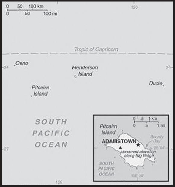
INTRODUCTION
Background: Polynesians were the first inhabitants of the Pitcairn Islands, but the islands were uninhabited by the time they were discovered by Europeans in 1606. Pitcairn Island was rediscovered by British explorer Philip CARTERET in 1767, although he incorrectly plotted the coordinates. In 1789, Fletcher CHRISTIAN led a mutiny on the HMS Bounty and after several months of searching for Pitcairn Island, he landed on it with eight other mutineers and their Tahitian companions. They lived in isolation and evaded detection by English authorities until 1808, by which point only one man, 10 women, and 23 children remained. In 1831, with the population growing too big for the island - there were 87 people - the British attempted to move all the islanders to Tahiti, but they were soon returned to Pitcairn Island. The island became an official British colony in 1838 and in 1856, the British again determined that the population of 193 was too high and relocated all of the residents to Norfolk Island. Several families returned in 1858 and 1864, bringing the island’s population to 43, and almost all of the island’s current population are descendants of these returnees.
The UK annexed the nearby islands of Henderson, Oeno, and Ducie in 1902 and incorporated them into the Pitcairn Islands colony in 1938, although all three are uninhabited. The population peaked at 233 in 1937 as outmigration, primarily to New Zealand, has thinned the population. Only two children were born between 1986 and 2012, and in 2005, a couple became the first new outsiders to obtain citizenship in more than a century. (The current population is below 50.) Since 2013, the Pitcairn Islands has tried to attract new migrants but has had no applicants because it requires prospective migrants to front significant sums of money and prohibits employment during a two-year trial period, at which point the local council can deny long-term resident status.
GEOGRAPHY
Location: Oceania, islands in the South Pacific Ocean, about midway between Peru and New Zealand
Geographic coordinates: 25 04 S, 130 06 W
Map references: Oceania
Area: total: 47 sq km
land: 47 sq km
water: 0 sq km
comparison ranking: total 233
Area - comparative: about three-tenths the size of Washington, DC
Land boundaries: total: 0 km
Coastline: 51 km
Maritime claims: territorial sea: 12 nm
exclusive economic zone: 200 nm
Climate: tropical; hot and humid; modified by southeast trade winds; rainy season (November to March)
Terrain: rugged volcanic formation; rocky coastline with cliffs
Elevation: highest point: Palwala Valley Point on Big Ridge 347 m
lowest point: Pacific Ocean 0 m
Natural resources: miro trees (used for handicrafts), fish; note - manganese, iron, copper, gold, silver, and zinc have been discovered offshore
Land use: agricultural land: 0% (2011 est.)
forest: 74.5% (2018 est.)
other: 25.5% (2018 est.)
Irrigated land: 0 sq km (2022)
Population distribution: less than 50 inhabitants on Pitcairn Island, most reside near the village of Adamstown
Natural hazards: occasional tropical cyclones (especially November to March), but generally only heavy tropical storms; landslides
Geography - note: Britain’s most isolated dependency; only the larger island of Pitcairn is inhabited but it has no port or natural harbor; supplies must be transported by rowed longboat from larger ships stationed offshore
PEOPLE AND SOCIETY
Population: 50 (2021 est.)
comparison ranking: 237
Nationality: noun: Pitcairn Islander(s)
adjective: Pitcairn Islander
Ethnic groups: descendants of the Bounty mutineers and their Tahitian wives
Languages: English (official), Pitkern (mixture of an 18th century English dialect and a Tahitian dialect)
Religions: Seventh Day Adventist 100%
Population growth rate: 0% (2014 est.)
comparison ranking: 196
Population distribution: less than 50 inhabitants on Pitcairn Island, most reside near the village of Adamstown
ENVIRONMENT
Environment - current issues: deforestation (only a small portion of the original forest remains because of burning and clearing for settlement)
Climate: tropical; hot and humid; modified by southeast trade winds; rainy season (November to March)
Land use: agricultural land: 0% (2011 est.)
forest: 74.5% (2018 est.)
other: 25.5% (2018 est.)
Urbanization: rate of urbanization: NA
GOVERNMENT
Country name: conventional long form: Pitcairn, Henderson, Ducie, and Oeno Islands
conventional short form: Pitcairn Islands
etymology: named after Midshipman Robert PITCAIRN who first sighted the island in 1767
Government type: parliamentary democracy
Dependency status: overseas territory of the UK
Capital: name: Adamstown
geographic coordinates: 25 04 S, 130 05 W
time difference: UTC-9 (4 hours behind Washington, DC, during Standard Time)
etymology: named after John ADAMS (1767–1829), the last survivor of the Bounty mutineers who settled on Pitcairn Island in January 1790
Administrative divisions: none (overseas territory of the UK)
Independence: none (overseas territory of the UK)
National holiday: Birthday of Queen ELIZABETH II, second Saturday in June (1926); Discovery Day (Pitcairn Day), 2 July (1767)
Constitution: history: several previous; latest drafted 10 February 2010, presented 17 February 2010, effective 4 March 2010
Legal system: local island by-laws
Citizenship: see United Kingdom
Suffrage: 18 years of age; universal with three years residency
Executive branch: chief of state: King CHARLES III (since 8 September 2022); represented by UK High Commissioner to New Zealand and Governor (nonresident) of the Pitcairn Islands Iona THOMAS (since 9 August 2022)
head of government: Mayor and Chairman of the Island Council Charlene WARREN-PEU (since 1 January 2020)
cabinet: none
elections/appointments: the monarchy is hereditary; governor and commissioner appointed by the monarch; island mayor directly elected by majority popular vote for a 3-year term; election last held on 9 November 2022 (next to be held not later than December 2025)
election results: Simon YOUNG elected mayor and chairman of the Island Council; Island Council vote - NA; took office 1 January 2023
Legislative branch: description: unicameral Island Council: 10 seats; (7 members - 5 councillors, the mayor, and the deputy mayor - elected by popular vote, and 3 ex officio non-voting members - the administrator, who serves as both the head of government and the representative of the governor of Pitcairn Islands, the governor, and the deputy governor; the councillors and the deputy mayor serve 2-year terms, the mayor serves a 3-year term, and the administrator is appointed by the governor for an indefinite term)
elections: last held on 6 November 2019 (next scheduled election - NA)
election results: percent of vote - NA; seats - 5 independent; composition - men 4, women 6, percent of women 60%
Judicial branch: highest court(s): Pitcairn Court of Appeal (consists of the court president, 2 judges, and the Supreme Court chief justice, an ex-officio member); Pitcairn Supreme Court (consists of the chief justice and 2 judges); note - appeals beyond the Pitcairn Court of Appeal are referred to the Judicial Committee of the Privy Council (in London)
judge selection and term of office: all judges of both courts appointed by the governor of the Pitcairn Islands on the instructions of the Queen of England through the Secretary of State; all judges can serve until retirement, normally at age 75
subordinate courts: Magistrate’s Court
Political parties and leaders: none
International organization participation: SPC, UPU
Diplomatic representation in the US: none (overseas territory of the UK)
Diplomatic representation from the US: embassy: none (overseas territory of the UK)
Flag description: blue with the flag of the UK in the upper hoist-side quadrant and the Pitcairn Islander coat of arms centered on the outer half of the flag; the green, yellow, and blue of the shield represents the island rising from the ocean; the green field features a yellow anchor surmounted by a bible (both the anchor and the bible were items found on the HMS Bounty); sitting on the crest is a Pitcairn Island wheelbarrow from which springs a flowering twig of miro (a local plant)
National anthem: name: “We From Pitcairn Island”
lyrics/music: unknown/Frederick M. LEHMAN
note: serves as a local anthem; as an overseas territory of the UK, “God Save the King” is official (see United Kingdom)
ECONOMY
Economic overview: small South Pacific British island territorial economy; exports primarily postage stamps, handicraft goods, honey, and tinctures; extremely limited infrastructure; dependent upon UK and EU aid; recent border reopening post-COVID-19
Agricultural products: honey; wide variety of fruits and vegetables; goats, chickens; fish
Industries: postage stamps, handicrafts, beekeeping, honey
Labor force: 15 (2004)
comparison ranking: 232
Labor force - by occupation: note: no business community in the usual sense; some public works; subsistence farming and fishing
Budget: revenues: $746,000 (FY04/05)
expenditures: $1.028 million (FY04/05)
Fiscal year: 1 April - 31 March
Exports - partners: South Africa 24%, Canada 20%, Germany 13%, Czechia 8%, El Salvador 5%, Spain 5% (2019)
Exports - commodities: leather footwear, gas turbine parts, precious metal ores, clothing and apparel, beef (2019)
Imports - partners: Ecuador 43%, New Zealand 29% (2019)
Imports - commodities: crude petroleum, refined petroleum, food preparation products, plastics, iron fasteners (2019)
Exchange rates: New Zealand dollars (NZD) per US dollar -
Exchange rates: 1.416 (2017 est.)
1.4279 (2016 est.)
1.4279 (2015)
1.4279 (2014 est.)
1.2039 (2013 est.)
COMMUNICATIONS
Telecommunication systems: general assessment: satellite-based phone services; rural connectivity a challenge; 2G services widespread; demand for mobile broadband due to mobile services providing Internet source; the launch of the Kacific-1 satellite in 2019 will improve telecommunications in the region (2020)
domestic: local phone service with international connections via Internet (2018)
international: country code - 872; satellite earth station - 1 Inmarsat
Broadcast media: satellite TV from Fiji-based Sky Pacific offering a wide range of international channels
Internet country code: .pn
Internet users: total: 37 (2021 est.)
percent of population: 96.2% (2021 est.)
comparison ranking: total 234
Communications - note: satellite-based local phone service and broadband Internet connections available in all homes
TRANSPORTATION
Ports and terminals: major seaport(s): Adamstown (on Bounty Bay)
MILITARY AND SECURITY
Military - note: defense is the responsibility of the UK
TRANSNATIONAL ISSUES
Disputes - international: none identified
POLAND
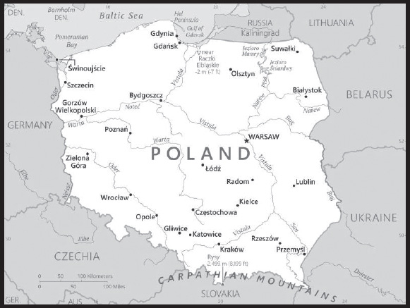
INTRODUCTION
Background: Poland’s history as a state began near the middle of the 10th century. By the mid-16th century, the Polish-Lithuanian Commonwealth ruled a vast tract of land in Central and Eastern Europe. During the 18th century, internal disorders weakened the nation, and in a series of agreements between 1772 and 1795, Russia, Prussia, and Austria partitioned Poland among themselves. Poland regained its independence in 1918 only to be overrun by Germany and the Soviet Union in World War II. It became a Soviet satellite state following the war. Labor turmoil in 1980 led to the formation of the independent trade union “Solidarity” that over time became a political force with over 10 million members. Free elections in 1989 and 1990 won Solidarity control of the parliament and the presidency, bringing the communist era to a close. A “shock therapy” program during the early 1990s enabled the country to transform its economy into one of the most robust in Central Europe. Poland joined NATO in 1999 and the EU in 2004.
GEOGRAPHY
Location: Central Europe, east of Germany
Geographic coordinates: 52 00 N, 20 00 E
Map references: Europe
Area: total: 312,685 sq km
land: 304,255 sq km
water: 8,430 sq km
comparison ranking: total 71
Area - comparative: about twice the size of Georgia; slightly smaller than New Mexico
Land boundaries: total: 2,865 km
border countries (6): Belarus 375 km; Czechia 699 km; Germany 467 km; Lithuania 100 km, Russia (Kaliningrad Oblast) 209 km; Slovakia 517 km; Ukraine 498 km
Coastline: 440 km
Maritime claims: territorial sea: 12 nm
exclusive economic zone: defined by international treaties
Climate: temperate with cold, cloudy, moderately severe winters with frequent precipitation; mild summers with frequent showers and thundershowers
Terrain: mostly flat plain; mountains along southern border
Elevation: highest point: Rysy 2,499 m
lowest point: near Raczki Elblaskie -2 m
mean elevation: 173 m
Natural resources: coal, sulfur, copper, natural gas, silver, lead, salt, amber, arable land
Land use: agricultural land: 48.2% (2018 est.)
arable land: 36.2% (2018 est.)
permanent crops: 1.3% (2018 est.)
permanent pasture: 10.7% (2018 est.)
forest: 30.6% (2018 est.)
other: 21.2% (2018 est.)
Irrigated land: 760 sq km (2013)
Major lakes (area sq km): salt water lake(s): Zalew Szczecinski/Stettiner Haff (shared with Germany) - 900 sq km
Major rivers (by length in km): Wisla (Vistula) river source and mouth (shared with Belarus and Ukraine) - 1,213 km
note – longest river in Poland
Major watersheds (area sq km): Atlantic Ocean drainage: (Black Sea) Danube (795,656 sq km)
Population distribution: population concentrated in the southern area around Krakow and the central area around Warsaw and Lodz, with an extension to the northern coastal city of Gdansk
Natural hazards: flooding
Geography - note: historically, an area of conflict because of flat terrain and the lack of natural barriers on the North European Plain
PEOPLE AND SOCIETY
Population: 37,991,766 (2023 est.)
comparison ranking: 39
Nationality: noun: Pole(s)
adjective: Polish
Ethnic groups: Polish 96.9%, Silesian 1.1%, German 0.2%, Ukrainian 0.1%, other and unspecified 1.7% (2011 est.)
note: represents ethnicity declared first
Languages: Polish (official) 98.2%, Silesian 1.4%, other 1.1%, unspecified 1.2%; note - data represent the language spoken at home; shares sum to more than 100% because some respondents gave more than one answer on the census; Poland ratified the European Charter for Regional or Minority Languages in 2009 recognizing Kashub as a regional language, Czech, Hebrew, Yiddish, Belarusian, Lithuanian, German, Armenian, Russian, Slovak, and Ukrainian as national minority languages, and Karaim, Lemko, Romani (Polska Roma and Bergitka Roma), and Tatar as ethnic minority languages (2011 est.)
major-language sample(s):
Księga Faktów Świata, niezbędne źródło podstawowych informacji. (Polish)
Religions: Catholic 85% (includes Roman Catholic 84.8% and other Catholic 0.3%), Orthodox 1.3% (almost all are Polish Autocephalous Orthodox), Protestant 0.4% (mainly Augsburg Evangelical and Pentecostal), other 0.3% (includes Jehovah’s Witness, Buddhist, Hare Krishna, Gaudiya Vaishnavism, Muslim, Jewish, Church of Jesus Christ), unspecified 12.9% (2020 est.)
Age structure: 0-14 years: 14.53% (male 2,839,788/female 2,680,401)
15-64 years: 64.87% (male 12,364,282/female 12,280,814)
65 years and over: 20.6% (2023 est.) (male 3,171,838/female 4,654,643)
Dependency ratios: total dependency ratio: 51.4
youth dependency ratio: 23.4
elderly dependency ratio: 28.6
potential support ratio: 3.5 (2021 est.)
Median age: total: 41.9 years (2020)
male: 40.3 years
female: 43.6 years
comparison ranking: total 39
Population growth rate: -0.28% (2023 est.)
comparison ranking: 213
Birth rate: 8.31 births/1,000 population (2023 est.)
comparison ranking: 213
Death rate: 10.75 deaths/1,000 population (2023 est.)
comparison ranking: 27
Net migration rate: -0.34 migrant(s)/1,000 population (2023 est.)
comparison ranking: 122
Population distribution: population concentrated in the southern area around Krakow and the central area around Warsaw and Lodz, with an extension to the northern coastal city of Gdansk
Urbanization: urban population: 60.2% of total population (2023)
rate of urbanization: -0.16% annual rate of change (2020-25 est.)
Major urban areas - population: 1.798 million WARSAW (capital), 769,000 Krakow (2023)
Sex ratio: at birth: 1.06 male(s)/female
0-14 years: 1.06 male(s)/female
15-64 years: 1.01 male(s)/female
65 years and over: 0.68 male(s)/female
total population: 0.94 male(s)/female (2023 est.)
Mother’s mean age at first birth: 27.9 years (2020 est.)
Maternal mortality ratio: 2 deaths/100,000 live births (2020 est.)
comparison ranking: 184
Infant mortality rate: total: 4.1 deaths/1,000 live births (2023 est.)
male: 4.52 deaths/1,000 live births
female: 3.65 deaths/1,000 live births
comparison ranking: total 186
Life expectancy at birth: total population: 79 years (2023 est.)
male: 75.28 years
female: 82.94 years
comparison ranking: total population 67
Total fertility rate: 1.41 children born/woman (2023 est.)
comparison ranking: 213
Gross reproduction rate: 0.69 (2023 est.)
Contraceptive prevalence rate: 62.3% (2014)
Drinking water source: improved: urban: 99.9% of population
rural: 100% of population
total: 100% of population
unimproved: urban: 0.1% of population
rural: 0% of population
total: 0% of population (2020 est.)
Current health expenditure: 6.5% of GDP (2020)
Physicians density: 3.77 physicians/1,000 population (2020)
Hospital bed density: 6.5 beds/1,000 population (2018)
Sanitation facility access: improved:
total: 100% of population
unimproved: total: 0% of population (2020 est.)
Major infectious diseases: degree of risk: intermediate (2023)
vectorborne diseases: tickborne encephalitis
Obesity - adult prevalence rate: 23.1% (2016)
comparison ranking: 68
Alcohol consumption per capita: total: 10.96 liters of pure alcohol (2019 est.)
beer: 5.72 liters of pure alcohol (2019 est.)
wine: 0.88 liters of pure alcohol (2019 est.)
spirits: 4.36 liters of pure alcohol (2019 est.)
other alcohols: 0 liters of pure alcohol (2019 est.)
comparison ranking: total 13
Tobacco use: total: 24% (2020 est.)
male: 27.9% (2020 est.)
female: 20.1% (2020 est.)
comparison ranking: total 59
Currently married women (ages 15-49): 56.6% (2023 est.)
Education expenditures: 5.2% of GDP (2020 est.)
comparison ranking: 69
Literacy: definition: age 15 and over can read and write
total population: 99.8%
male: 99.8%
female: 99.8% (2021)
School life expectancy (primary to tertiary education): total: 16 years
male: 15 years
female: 17 years (2020)
Youth unemployment rate (ages 15-24): total: 13.4% (2021 est.)
male: 12.3%
female: 15%
comparison ranking: total 131
ENVIRONMENT
Environment - current issues: decreased emphasis on heavy industry and increased environmental concern by post-communist governments has improved environment; air pollution remains serious because of emissions from burning low-quality coals in homes and from coal-fired power plants; the resulting acid rain causes forest damage; water pollution from industrial and municipal sources is a problem, as is disposal of hazardous wastes
Environment - international agreements: party to: Air Pollution, Air Pollution-Nitrogen Oxides, Air Pollution-Sulphur 94, Antarctic-Environmental Protection, Antarctic- Marine Living Resources, Antarctic Seals, Antarctic Treaty, Biodiversity, Climate Change, Climate Change- Kyoto Protocol, Climate Change-Paris Agreement, Comprehensive Nuclear Test Ban, Desertification, Endangered Species, Environmental Modification, Hazardous Wastes, Law of the Sea, Marine Dumping-London Convention, Nuclear Test Ban, Ozone Layer Protection, Ship Pollution, Tropical Timber 2006, Wetlands, Whaling
signed, but not ratified: Air Pollution-Heavy Metals, Air Pollution-Multi-effect Protocol, Air Pollution-Persistent Organic Pollutants
Climate: temperate with cold, cloudy, moderately severe winters with frequent precipitation; mild summers with frequent showers and thundershowers
Land use: agricultural land: 48.2% (2018 est.)
arable land: 36.2% (2018 est.)
permanent crops: 1.3% (2018 est.)
permanent pasture: 10.7% (2018 est.)
forest: 30.6% (2018 est.)
other: 21.2% (2018 est.)
Urbanization: urban population: 60.2% of total population (2023)
rate of urbanization: -0.16% annual rate of change (2020-25 est.)
Revenue from forest resources: 0.17% of GDP (2018 est.)
comparison ranking: 98
Revenue from coal: 0.27% of GDP (2018 est.)
comparison ranking: 19
Air pollutants: particulate matter emissions: 18.83 micrograms per cubic meter (2019 est.)
carbon dioxide emissions: 299.04 megatons (2016 est.)
methane emissions: 46.62 megatons (2020 est.)
Waste and recycling: municipal solid waste generated annually: 10.863 million tons (2015 est.)
municipal solid waste recycled annually: 2,866,746 tons (2015 est.)
percent of municipal solid waste recycled: 26.4% (2015 est.)
Major lakes (area sq km): salt water lake(s): Zalew Szczecinski/Stettiner Haff (shared with Germany) - 900 sq km
Major rivers (by length in km): Wisla (Vistula) river source and mouth (shared with Belarus and Ukraine) - 1,213 km
note - longest river in Poland
Major watersheds (area sq km): Atlantic Ocean drainage: (Black Sea) Danube (795,656 sq km)
Total water withdrawal: municipal: 1.96 billion cubic meters (2020 est.)
industrial: 5.87 billion cubic meters (2020 est.)
agricultural: 1.39 billion cubic meters (2020 est.)
Total renewable water resources: 60.5 billion cubic meters (2020 est.)
GOVERNMENT
Country name: conventional long form: Republic of Poland
conventional short form: Poland
local long form: Rzeczpospolita Polska
local short form: Polska
former: Polish People’s Republic
etymology: name derives from the Polanians, a west Slavic tribe that united several surrounding Slavic groups (9th-10th centuries A.D.) and who passed on their name to the country; the name of the tribe likely comes from the Slavic “pole” (field or plain), indicating the flat nature of their country
Government type: parliamentary republic
Capital: name: Warsaw
geographic coordinates: 52 15 N, 21 00 E
time difference: UTC+1 (6 hours ahead of Washington, DC, during Standard Time)
daylight saving time: +1hr, begins last Sunday in March; ends last Sunday in October
etymology: the origin of the name is unknown; the Polish designation “Warszawa” was the name of a fishing village and several legends/traditions link the city’s founding to a man named Wars or Warsz
Administrative divisions: 16 voivodships [provinces] (wojewodztwa, singular - wojewodztwo); Dolnoslaskie (Lower Silesia), Kujawsko-Pomorskie (Kuyavia-Pomerania), Lodzkie (Lodz), Lubelskie (Lublin), Lubuskie (Lubusz), Malopolskie (Lesser Poland), Mazowieckie (Masovia), Opolskie (Opole), Podkarpackie (Subcarpathia), Podlaskie, Pomorskie (Pomerania), Slaskie (Silesia), Swietokrzyskie (Holy Cross), Warminsko-Mazurskie (Warmia-Masuria), Wielkopolskie (Greater Poland), Zachodniopomorskie (West Pomerania)
Independence: 11 November 1918 (republic proclaimed); notable earlier dates: 14 April 966 (adoption of Christianity, traditional founding date), 1 July 1569 (Polish-Lithuanian Commonwealth created)
National holiday: Constitution Day, 3 May (1791)
Constitution: history: several previous; latest adopted 2 April 1997, approved by referendum 25 May 1997, effective 17 October 1997
amendments: proposed by at least one fifth of Sejm deputies, by the Senate, or by the president of the republic; passage requires at least two-thirds majority vote in the Sejm and absolute majority vote in the Senate; amendments to articles relating to sovereignty, personal freedoms, and constitutional amendment procedures also require passage by majority vote in a referendum; amended 2006, 2009
Legal system: civil law system; judicial review of legislative, administrative, and other governmental acts; constitutional law rulings of the Constitutional Tribunal are final
International law organization participation: accepts compulsory ICJ jurisdiction with reservations; accepts ICCt jurisdiction
Citizenship: citizenship by birth: no
citizenship by descent only: both parents must be citizens of Poland
dual citizenship recognized: no
residency requirement for naturalization: 5 years
Suffrage: 18 years of age; universal
Executive branch: chief of state: President Andrzej DUDA (since 6 August 2015)
head of government: Prime Minister Mateusz MORAWIECKI (since 11 December 2017); Deputy Prime Ministers Piotr GLINSKI (since 16 November 2015), Jacek SASIN (since 15 November 2019), Henryk KOWALCZYK (since 26 October 2021), and Mariusz BLASZCZAK (since 22 June 2022)
cabinet: Council of Ministers proposed by the prime minister, appointed by the president, and approved by the Sejm
elections/appointments: president directly elected by absolute majority popular vote in 2 rounds if needed for a 5-year term (eligible for a second term); election last held on 28 June 2020 with a second round on 12 July 2020 (next to be held in 2025); prime minister, deputy prime ministers, and Council of Ministers appointed by the president and confirmed by the Sejm; all presidential candidates resign their party affiliation
election results:
2020: Andrzej DUDA reelected president in second round; percent of vote - Andrzej DUDA (independent) 51%, Rafal TRZASKOWSKI (KO) 49%
2015: Andrzej DUDA elected president in second round; percent of vote - Andrzej DUDA (independent) 51.5%, Bronislaw KOMOROWSKI (independent) 48.5%
Legislative branch: description: bicameral Parliament consists of:
Senate or Senat (100 seats; members directly elected in single-seat constituencies by simple majority vote to serve 4-year terms)
Sejm (460 seats; members elected in multi-seat constituencies by party-list proportional representation vote with 5% threshold of total votes needed for parties and 8% for coalitions to gain seats; minority parties exempt from threshold; members serve 4-year terms)
elections:
Senate - last held on 15 October 2023 (next to be held in 2027)
Sejm - last held on 15 October 2023 (next to be held in 2027)
election results:
Senate - percent of vote by party - NA; seats by party - NA
Sejm (preliminary results as of 10/15/2023): PiS 35.4%, KO 30.7%, TD 14.4%, Lewica 8.6%, Konf 7.2%; seats by party - PiS 194, KO 157, TD 65, Lewica 26, Konf 18
note: the designation National Assembly or Zgromadzenie Narodowe is only used on those rare occasions when the 2 houses meet jointly
Judicial branch: highest court(s): Supreme Court or Sad Najwyzszy (consists of the first president of the Supreme Court and 120 justices organized in criminal, civil, labor and social insurance, and extraordinary appeals and public affairs and disciplinary chambers); Constitutional Tribunal (consists of 15 judges, including the court president and vice president)
judge selection and term of office: president of the Supreme Court nominated by the General Assembly of the Supreme Court and selected by the president of Poland; other judges nominated by the 25-member National Judicial Council and appointed by the president of Poland; judges serve until retirement, usually at age 65, but tenure can be extended; Constitutional Tribunal judges chosen by the Sejm for single 9-year terms
subordinate courts: administrative courts; military courts; local, regional and appellate courts subdivided into military, civil, criminal, labor, and family courts
Political parties and leaders: Agreement [Jaroslaw GOWIN]
Civic Platform or PO [Donald TUSK]
Konfederajca [Krzysztof BOSAK]
Law and Justice or PiS [Jaroslaw KACZYNSKI]
New Left or NL [Wlodzimierz CZARZASTY and Robert BIEDRON]
Poland 2050 [Szymon HOLOWNIA]
Polish People’s Party or PSL [Wladyslaw KOSINIAK-KAMYSZ]
Republican Party or R [Adam BIELAN]
United Poland or SP [Zbigniew ZIOBRO]
International organization participation: Arctic Council (observer), Australia Group, BIS, BSEC (observer), CBSS, CD, CE, CEI, CERN, EAPC, EBRD, ECB, EIB, ESA, EU, FAO, IAEA, IBRD, ICAO, ICC (national committees), ICCt, ICRM, IDA, IEA, IFC, IFRCS, IHO, ILO, IMF, IMO, IMSO, Interpol, IOC, IOM, IPU, ISO, ITSO, ITU, ITUC (NGOs), MIGA, MONUSCO, NATO, NEA, NSG, OAS (observer), OECD, OIF (observer), OPCW, OSCE, PCA, Schengen Convention, UN, UNCTAD, UNESCO, UNHCR, UNHRC, UNIDO, UNMIL, UNMISS, UNOCI, UN Security Council (temporary), UNWTO, UPU, Wassenaar Arrangement, WCO, WFTU (NGOs), WHO, WIPO, WMO, WTO, ZC
Diplomatic representation in the US: chief of mission: Ambassador Marek Grzegorz MAGIEROWSKI (since 13 January 2022)
chancery: 2640 16th Street NW, Washington, DC 20009
telephone: [1] (202) 499-1700
FAX: [1] (202) 328-2152; [1] (202) 328-6271
email address and website:
washington.amb.sekretariat@msz.gov.pl
https://www.gov.pl/web/usa-en/embassy-washington
consulate(s) general: Chicago, Houston, Los Angeles, New York
Diplomatic representation from the US: chief of mission: Ambassador Mark BRZEZINSKI (since 19 January 2022)
embassy: Aleje Ujazdowskie 29/31, 00-540 Warsaw
mailing address: 5010 Warsaw Place, Washington, DC 20521-5010
telephone: [48] (22) 504-2000
FAX: [48] (22) 504-2088
email address and website:
consulate(s) general: Krakow
Flag description: two equal horizontal bands of white (top) and red; colors derive from the Polish emblem - a white eagle on a red field
note: similar to the flags of Indonesia and Monaco which are red (top) and white
National symbol(s): white crowned eagle; national colors: white, red
National anthem: name: “Mazurek Dabrowskiego” (Dabrowski’s Mazurka)
lyrics/music: Jozef WYBICKI/traditional
note: adopted 1927; the anthem, commonly known as “Jeszcze Polska nie zginela” (Poland Has Not Yet Perished), was written in 1797; the lyrics resonate strongly with Poles because they reflect the numerous occasions in which the nation’s lands have been occupied
National heritage: total World Heritage Sites: 17 (15 cultural, 2 natural)
selected World Heritage Site locales: Historic Krakow (c); Historic Warsaw (c); Medieval Torun (c); Wooden Tserkvas of the Carpathian Region (c); Castle of the Teutonic Order in Malbork (c); Wieliczka and Bochnia Royal Salt Mines (c); Auschwitz Birkenau Concentration Camp (c); Ancient and Primeval Beech Forests of the Carpathians (n); Białowieza Forest (n); Old City of Zamość (c)
ECONOMY
Economic overview: diversified, high-growth European economy; COVID-19 led to first recession in nearly 3 decades, albeit small; EU and NATO member; bolstering US relations; economic concentration in western region; aging labor force; growing debt
Real GDP (purchasing power parity): $1.318 trillion (2021 est.)
$1.233 trillion (2020 est.)
$1.259 trillion (2019 est.)
note: data are in 2017 dollars
comparison ranking: 19
Real GDP growth rate: 6.85% (2021 est.)
-2.02% (2020 est.)
4.45% (2019 est.)
comparison ranking: 61
Real GDP per capita: $34,900 (2021 est.)
$32,500 (2020 est.)
$33,200 (2019 est.)
note: data are in 2017 dollars
comparison ranking: 59
GDP (official exchange rate): $595.72 billion (2019 est.)
Inflation rate (consumer prices): 5.06% (2021 est.)
3.37% (2020 est.)
2.23% (2019 est.)
comparison ranking: 66
Credit ratings: Fitch rating: A- (2007)
Moody’s rating: A2 (2002)
Standard & Poors rating: A- (2018)
note: The year refers to the year in which the current credit rating was first obtained.
GDP - composition, by sector of origin: agriculture: 2.4% (2017 est.)
industry: 40.2% (2017 est.)
services: 57.4% (2017 est.)
comparison rankings: services 139; industry 30; agriculture 165
GDP - composition, by end use: household consumption: 58.6% (2017 est.)
government consumption: 17.7% (2017 est.)
investment in fixed capital: 17.7% (2017 est.)
investment in inventories: 2% (2017 est.)
exports of goods and services: 54% (2017 est.)
imports of goods and services: -49.9% (2017 est.)
Agricultural products: milk, sugar beets, wheat, potatoes, triticale, maize, barley, apples, mixed grains, rye
Industries: machine building, iron and steel, coal mining, chemicals, shipbuilding, food processing, glass, beverages, textiles
Industrial production growth rate: 3.36% (2021 est.)
comparison ranking: 116
Labor force: 18.212 million (2021 est.)
comparison ranking: 35
Labor force - by occupation: agriculture: 11.5%
industry: 30.4%
services: 57.6% (2015)
Unemployment rate: 3.37% (2021 est.)
3.16% (2020 est.)
3.28% (2019 est.)
comparison ranking: 191
Youth unemployment rate (ages 15-24): total: 13.4% (2021 est.)
male: 12.3%
female: 15%
comparison ranking: total 131
Population below poverty line: 15.4% (2018 est.)
Gini Index coefficient - distribution of family income: 30.2 (2018 est.)
comparison ranking: 147
Average household expenditures: on food: 16.7% of household expenditures (2018 est.)
on alcohol and tobacco: 5.7% of household expenditures (2018 est.)
Household income or consumption by percentage share: lowest 10%: 3%
highest 10%: 23.9% (2015 est.)
Budget: revenues: $244.485 billion (2019 est.)
expenditures: $248.868 billion (2019 est.)
Budget surplus (+) or deficit (-): -1.7% (of GDP) (2017 est.)
comparison ranking: 94
Public debt: 50.6% of GDP (2017 est.)
54.2% of GDP (2016 est.)
note: data cover general government debt and include debt instruments issued (or owned) by government entities other than the treasury; the data include treasury debt held by foreign entities, the data include subnational entities, as well as intragovernmental debt; intragovernmental debt consists of treasury borrowings from surpluses in the social funds, such as for retirement, medical care, and unemployment; debt instruments for the social funds are not sold at public auctions comparison ranking: 105
Taxes and other revenues: 17.48% (of GDP) (2020 est.)
comparison ranking: 114
Fiscal year: calendar year
Current account balance: -$4.568 billion (2021 est.)
$17.319 billion (2020 est.)
$2.832 billion (2019 est.)
comparison ranking: 184
Exports: $411.621 billion (2021 est.) note: data are in current year dollars
$336.317 billion (2020 est.) note: data are in current year dollars
$330.934 billion (2019 est.) note: data are in current year dollars
comparison ranking: 20
Exports - partners: Germany 28%, UK 6%, Czechia 6%, France 6%, Netherlands 4% (2020)
Exports - commodities: cars and vehicle parts, seats, furniture, electric batteries, computers (2020)
Imports: $380.699 billion (2021 est.) note: data are in current year dollars
$295.897 billion (2020 est.) note: data are in current year dollars
$302.525 billion (2019 est.) note: data are in current year dollars
comparison ranking: 19
Imports - partners: Germany 25%, China 12%, Italy 5%, Netherlands 5%, Czechia 4% (2020)
Imports - commodities: cars and vehicle parts, crude petroleum, packaged medicines, broadcasting equipment, office machinery/parts (2020)
Reserves of foreign exchange and gold: $166.03 billion (31 December 2021 est.)
$154.219 billion (31 December 2020 est.)
$128.392 billion (31 December 2019 est.)
comparison ranking: 21
Debt - external: $351.77 billion (2019 est.)
$373.721 billion (2018 est.)
comparison ranking: 32
Exchange rates: zlotych (PLN) per US dollar -
Exchange rates: 3.862 (2021 est.)
3.9 (2020 est.)
3.839 (2019 est.)
3.612 (2018 est.)
3.779 (2017 est.)
ENERGY
Electricity access: electrification - total population: 100% (2021)
Electricity: installed generating capacity: 47.269 million kW (2020 est.)
consumption: 149.203 billion kWh (2020 est.)
exports: 7.357 billion kWh (2020 est.)
imports: 20.624 billion kWh (2020 est.)
transmission/distribution losses: 9.995 billion kWh (2020 est.)
comparison rankings: transmission/distribution losses 31; imports 10; exports 25; consumption 25; installed generating capacity 26
Electricity generation sources: fossil fuels: 79.8% of total installed capacity (2020 est.)
solar: 1.4% of total installed capacity (2020 est.)
wind: 10.8% of total installed capacity (2020 est.)
hydroelectricity: 2% of total installed capacity (2020 est.)
biomass and waste: 6% of total installed capacity (2020 est.)
Coal: production: 108.152 million metric tons (2020 est.)
consumption: 110.674 million metric tons (2020 est.)
exports: 11.063 million metric tons (2020 est.)
imports: 13.281 million metric tons (2020 est.)
proven reserves: 26.932 billion metric tons (2019 est.)
Petroleum: total petroleum production: 28,400 bbl/day (2021 est.)
refined petroleum consumption: 697,700 bbl/day (2019 est.)
crude oil and lease condensate exports: 6,000 bbl/day (2018 est.)
crude oil and lease condensate imports: 542,100 bbl/day (2018 est.)
crude oil estimated reserves: 113 million barrels (2021 est.)
Refined petroleum products - production: 554,200 bbl/day (2017 est.)
comparison ranking: 30
Refined petroleum products - exports: 104,800 bbl/day (2017 est.)
comparison ranking: 43
Refined petroleum products - imports: 222,300 bbl/day (2017 est.)
comparison ranking: 32
Natural gas: production: 5.667 billion cubic meters (2020 est.)
consumption: 21.464 billion cubic meters (2020 est.)
exports: 704.975 million cubic meters (2019 est.)
imports: 16.633 billion cubic meters (2020 est.)
proven reserves: 91.492 billion cubic meters (2021 est.)
Carbon dioxide emissions: 304.04 million metric tonnes of CO2 (2019 est.)
from coal and metallurgical coke: 176.938 million metric tonnes of CO2 (2019 est.)
from petroleum and other liquids: 89.944 million metric tonnes of CO2 (2019 est.)
from consumed natural gas: 37.158 million metric tonnes of CO2 (2019 est.)
comparison ranking: total emissions 21
Energy consumption per capita: 112.831 million Btu/person (2019 est.)
comparison ranking: 48
COMMUNICATIONS
Telephones - fixed lines: total subscriptions: 5,308,497 (2021 est.)
subscriptions per 100 inhabitants: 14 (2021 est.)
comparison ranking: total subscriptions 25
Telephones - mobile cellular: total subscriptions: 50,588,785 (2021 est.)
subscriptions per 100 inhabitants: 132 (2021 est.)
comparison ranking: total subscriptions 33
Telecommunication systems: general assessment: the liberalized telecom market has seen considerable development in the broadband and mobile sectors; the regulatory environment has encouraged market competition, partly by encouraging operators to secure spectrum and also by ensuring access to cable and fiber infrastructure; the mobile market in recent years has been characterized by the rapid extension of LTE and 5G networks, and the development of mobile data services based on newly released and re-farmed spectrum; the regulator’s attempts to auction spectrum in a range of bands has been delayed, with spectrum in the 5G-suitable 3.4-3.8GHz range having been put back to later in 2023 as a result of the Covid-19 outbreak and changes to legislation (2021)
domestic: fixed-line is 14 per 100 (service lags in rural areas), mobile-cellular is 132 per 100 persons (2021)
international: country code - 48; landing points for the Baltica and the Denmark-Poland2 submarine cables connecting Poland, Denmark and Sweden; international direct dialing with automated exchanges; satellite earth station - 1 with access to Intelsat, Eutelsat, Inmarsat, and Intersputnik (2019)
Broadcast media: state-run public TV operates 2 national channels supplemented by 16 regional channels and several niche channels; privately owned entities operate several national TV networks and a number of special interest channels; many privately owned channels broadcasting locally; roughly half of all households are linked to either satellite or cable TV systems providing access to foreign television networks; state-run public radio operates 5 national networks and 17 regional radio stations; 2 privately owned national radio networks, several commercial stations broadcasting to multiple cities, and many privately owned local radio stations (2019)
Internet country code: .pl
Internet users: total: 32.3 million (2021 est.)
percent of population: 85% (2021 est.)
comparison ranking: total 31
Broadband - fixed subscriptions: total: 8,369,218 (2020 est.)
subscriptions per 100 inhabitants: 22 (2020 est.)
comparison ranking: total 24
TRANSPORTATION
National air transport system: number of registered air carriers: 6 (2020)
inventory of registered aircraft operated by air carriers: 169
annual passenger traffic on registered air carriers: 9,277,538 (2018)
annual freight traffic on registered air carriers: 271.49 million (2018) mt-km
Civil aircraft registration country code prefix: SP
Airports: 126 (2021)
comparison ranking: total 46
Airports - with paved runways: 87
civil airports: 13
military airports: 13
joint use (civil-military) airports: 0
other airports: 61
note: paved runways have a concrete or asphalt surface but not all have facilities for refueling, maintenance, or air traffic control; the length of a runway required for aircraft to safely operate depends on a number of factors including the type of aircraft, the takeoff weight (including passengers, cargo, and fuel), engine types, flap settings, landing speed, elevation of the airport, and average maximum daily air temperature; paved runways can reach a length of 5,000 m (16,000 ft.), but the “typical” length of a commercial airline runway is between 2,500-4,000 m (8,000-13,000 ft.)
Airports - with unpaved runways: 39
note: unpaved runways have a surface composition such as grass or packed earth and are most suited to the operation of light aircraft; unpaved runways are usually short, often less than 1,000 m (3,280 ft.) in length; airports with unpaved runways often lack facilities for refueling, maintenance, or air traffic control
Heliports: 6 (2021)
Pipelines: 14,198 km gas, 1,374 km oil, 2,483 km refined products (2018)
Railways: total: 19,461 km (2020) 11,946 km electrified
comparison ranking: total 14
Roadways: total: 420,000 km (2016)
paved: 291,000 km (2016) (includes 1,492 km of expressways, 1,559 of motorways)
unpaved: 129,000 km (2016)
comparison ranking: total 18
Waterways: 3,997 km (2009) (navigable rivers and canals)
comparison ranking: 29
Merchant marine: total: 149 (2022)
by type: general cargo 7, oil tanker 6, other 136
comparison ranking: total 73
Ports and terminals: major seaport(s): Gdansk, Gdynia, Swinoujscie
container port(s) (TEUs): Gdansk (2,117,829) (2021)
LNG terminal(s) (import): Swinoujscie
river port(s): Szczecin (River Oder)
MILITARY AND SECURITY
Military and security forces: Polish Armed Forces (Polskie Siły Zbrojne): Land Forces (Wojska Ladowe), Navy (Marynarka Wojenna), Air Force (Sily Powietrzne), Special Forces (Wojska Specjalne), Territorial Defense Forces (Wojska Obrony Terytorialnej)
Ministry of Interior and Administration: Polish National Police (Policja); Border Guard (Straż Graniczna or SG) (2023)
note: as of 2023, Cyberspace Defense Forces (Wojska Obrony Cyberprzestrzeni) were in development
Military expenditures: 3.9% of GDP (2023 est.)
2.4% of GDP (2022 est.)
2.2% of GDP (2021)
2.2% of GDP (2020)
2% of GDP (2019)
comparison ranking: 20
Military and security service personnel strengths: approximately 120,000 active-duty personnel (65,000 Army; 7,000 Navy; 15,000 Air Force; 3,000 Special Forces; 30,000 joint service/other); approximately 40,000 Territorial Defense Forces (2023)
note: in June 2019, the Polish Government approved a plan to increase the size of the military over a period of 10 years to over 200,000 troops, including doubling the size of the Territorial Defense Forces; in 2021, it announced additional plans to increase the size of the military to over 300,000 personnel
Military equipment inventories and acquisitions: the military’s inventory consists of a mix of Soviet-era and more modern, NATO-compatible, weapons systems; in recent years, the leading suppliers of armaments have included several European countries, South Korea, and the US; Poland has a large domestic defense sector that produces or provides upgrades to a wide variety of weapons systems, particularly ground systems such as tanks and other armored vehicles; it also cooperates with the European and US defense sectors (2023)
note: in late 2018, Poland announced a 7-year (through 2026) approximately $50 billion defense modernization plan that would include such items as 5th generation combat aircraft, unmanned aerial vehicles, rocket artillery, helicopters, submarines, frigates, and improved cyber security; in 2022, it signed large military weapons contracts with South Korea and the US
Military service age and obligation: 18-28 years of age for male and female voluntary military service; conscription phased out in 2009-12; professional soldiers serve on a permanent basis (for an unspecified period of time) or on a contract basis (for a specified period of time); initial contract period is 24 months; women serve in the military on the same terms as men (2023)
note 1: as of 2019, women made up about 7% of the military’s full-time personnel
note 2: in May 2022, Poland announced a new 12-month voluntary military service program with recruits going through a one-month basic training period with a military unit, followed by 11 months of specialized training; upon completion of service, the volunteers would be allowed to join the Territorial Defense Forces or the active reserve, and have priority to join the professional army and be given preference for employment in the public sector; the program is part of an effort to increase the size of the Polish military
Military deployments: 250 Kosovo (NATO/KFOR); up to 180 Latvia (NATO); 200 Lebanon (UNIFIL); 230 Romania (NATO) (2023)
note 1: Poland has obligated about 2,500 troops to the Lithuania, Poland, and Ukraine joint military brigade (LITPOLUKRBRIG), which was established in 2014; the brigade is headquartered in Poland and is comprised of an international staff, three battalions, and specialized units; units affiliated with the multinational brigade remain within the structures of the armed forces of their respective countries until the brigade is activated for participation in an international operation
note 2: in response to Russia’s 2022 invasion of Ukraine, some NATO countries, including Poland, have committed additional troops and equipment to the battlegroups deployed in NATO territory in the Baltic States and eastern Europe
Military - note: Poland’s geographic location on NATO’s eastern flank and its history of foreign invasion underpin the Polish military’s heavy focus on territorial and border defense and supporting its NATO and EU security commitments; its chief concern is Russian aggression, particularly following Moscow’s seizure of Crimea in 2014 and full-scale invasion of neighboring Ukraine in 2022, which has led to increased defense spending and modernization efforts, as well as efforts to boost the NATO and US military presence; since 2014, Poland has been hosting several NATO military formations designed to enhance the defense of Poland and NATO’s eastern flank, including a US-led multinational NATO ground force battlegroup as part of the Alliance’s Enhanced Forward Presence initiative, NATO fighter detachments at Malbork Air Base, a NATO-led divisional headquarters (Multinational Division Northeast), which coordinates training and preparation activities of its respective subordinate battlegroups in Poland and Lithuania, and a corps-level NATO field headquarters (Multinational Corps Northeast); in 2022, the US announced it would establish a permanent corps headquarters in Poland to command US rotational forces in Europe; Poland also participates in a variety of EU and NATO military deployments in Africa, the Baltic States, Southern Europe, and the Middle East; Poland provided considerable support to the NATO mission in Afghanistan, where more than 30,000 military personnel served over a 20-year period before the mission ended in 2021
the Polish military is a professional and volunteer force that exercises regularly, including with NATO partners; it is organized into a General Staff, an Armed Forces General Command, an Armed Forces Operational Command, Territorial Defense Forces (established 2017), Military Police, and the Warsaw Garrison Command; the Army is comprised of several armored cavalry and mechanized infantry divisions, which are complemented by independent airborne, air mobile, and aviation brigades, as well as armored reconnaissance and artillery regiments ; the active forces are backed up by the Territorial Defense Forces, which have nearly 20 light infantry brigades manned by part-time reserve personnel; the Navy is a compact force for defending Poland’s territorial waters, coastline, and its interests abroad, as well as providing support to NATO missions; its principal warships are two frigates, two corvettes, three attack submarines, and a few fast-attack craft; it also has a considerable force of mine warfare vessels, as well as a naval aviation brigade focused on anti-submarine warfare and maritime patrolling; the Air Force has a mix of about 80 Soviet-era and more modern US fighter aircraft; it has more advanced US (F-35s) and South Korean (FA-50s) on order to replace its Soviet-era inventory beginning in 2024; Poland also has a joint special forces command with air, ground, and maritime components (2023)
SPACE
Space agency/agencies: Polish Space Agency (POLSA; established 2014; operational in 2015); Space Research Center (SRC, interdisciplinary research institute of the Polish Academy of Sciences that acted as Poland’s space agency until POLSA was established in 1977) (2023)
Space program overview: space program is integrated within the framework of the European Space Agency (ESA); builds satellites, including nano/cube remote sensing (RS) and educational/scientific/technology satellites; researches and develops communications, RS, navigational, and other scientific applications for satellite payloads; creating infrastructure for receiving, storing, processing and distributing data from meteorological and environmental satellites; researches and develops other space-related technologies, including sensors and robotic probes for interplanetary landers, and launcher systems; participates in international space programs and cooperates with a variety of foreign space agencies and industries, including those of Brazil, Canada, China, ESA/EU member states (particularly France, Germany, Italy), India, Japan, Mexico, Russia, Ukraine, UK, and the US; has a growing commercial space sector with more than 300 active enterprises (2023)
note: further details about the key activities, programs, and milestones of the country’s space program, as well as government spending estimates on the space sector, appear in Appendix S
TERRORISM
Terrorist group(s): Terrorist group(s): Islamic State of Iraq and ash-Sham (ISIS)
note: details about the history, aims, leadership, organization, areas of operation, tactics, targets, weapons, size, and sources of support of the group(s) appear(s) in Appendix-T
TRANSNATIONAL ISSUES
Disputes - international: Poland-Belarus-Ukraine: as a member state that forms part of the EU’s external border, Poland has implemented the strict Schengen border rules to restrict illegal immigration and trade along its eastern borders with Belarus and Ukraine
Refugees and internally displaced persons: refugees (country of origin): 954,600 (Ukraine) (as of 20 November 2023)
stateless persons: 1,435 (2022)
Illicit drugs: a major source of precursor or essential chemicals used in the production of illicit narcotics
PORTUGAL
INTRODUCTION
Background: Following its heyday as a global maritime power during the 15th and 16th centuries, Portugal lost much of its wealth and status with the destruction of Lisbon in a 1755 earthquake, occupation during the Napoleonic Wars, and the independence of Brazil, its wealthiest colony, in 1822. A 1910 revolution deposed the monarchy, and for most of the next six decades, repressive governments ran the country. In 1974, a left-wing military coup installed broad democratic reforms. The following year, Portugal granted independence to all of its African colonies. Portugal is a founding member of NATO and entered the EC (now the EU) in 1986.
GEOGRAPHY
Location: Southwestern Europe, bordering the North Atlantic Ocean, west of Spain
Geographic coordinates: 39 30 N, 8 00 W
Map references: Europe
Area: total: 92,090 sq km
land: 91,470 sq km
water: 620 sq km
note: includes Azores and Madeira Islands
comparison ranking: total 111
Area - comparative: slightly smaller than Virginia
Land boundaries: total: 1,224 km
border countries (1): Spain 1,224 km
Coastline: 1,793 km
Maritime claims: territorial sea: 12 nm
contiguous zone: 24 nm
exclusive economic zone: 200 nm
continental shelf: 200-m depth or to the depth of exploitation
Climate: maritime temperate; cool and rainy in north, warmer and drier in south
Terrain: the west-flowing Tagus River divides the country: the north is mountainous toward the interior, while the south is characterized by rolling plains
Elevation: highest point: Ponta do Pico (Pico or Pico Alto) on Ilha do Pico in the Azores 2,351 m
lowest point: Atlantic Ocean 0 m
mean elevation: 372 m
Natural resources: fish, forests (cork), iron ore, copper, zinc, tin, tungsten, silver, gold, uranium, marble, clay, gypsum, salt, arable land, hydropower
Land use: agricultural land: 39.7% (2018 est.)
arable land: 11.9% (2018 est.)
permanent crops: 7.8% (2018 est.)
permanent pasture: 20% (2018 est.)
forest: 37.8% (2018 est.)
other: 22.5% (2018 est.)
Irrigated land: 5,662 sq km (2019)
Population distribution: concentrations are primarily along or near the Atlantic coast; both Lisbon and the second largest city, Porto, are coastal cities
Natural hazards: Azores subject to severe earthquakes
volcanism: limited volcanic activity in the Azores Islands; Fayal or Faial (1,043 m) last erupted in 1958; most volcanoes have not erupted in centuries; historically active volcanoes include Agua de Pau, Furnas, Pico, Picos Volcanic System, San Jorge, Sete Cidades, and Terceira
Geography - note: Azores and Madeira Islands occupy strategic locations along western sea approaches to Strait of Gibraltar; they are two of the four North Atlantic archipelagos that make up Macaronesia; the others are the Canary Islands (Spain) and Cabo Verde
PEOPLE AND SOCIETY
Population: 10,223,150 (2023 est.)
comparison ranking: 91
Nationality: noun: Portuguese (singular and plural)
adjective: Portuguese
Ethnic groups: Portuguese 95%; citizens from Portugal’s former colonies in Africa, Asia (Han Chinese), and South America (Brazilian) and other foreign born 5%
Languages: Portuguese (official), Mirandese (official, but locally used)
Religions: Roman Catholic 79.7%, Protestant 2.2%, other Christian 2.5%, other non-Christian, 1.1%, none 14.5% (2021 est.)
note: data represent population 15 years of age and older
Age structure: 0-14 years: 12.85% (male 672,673/female 641,409)
15-64 years: 65.18% (male 3,274,201/female 3,389,374)
65 years and over: 21.96% (2023 est.) (male 895,576/female 1,349,917)
Dependency ratios: total dependency ratio: 56
youth dependency ratio: 20.8
elderly dependency ratio: 35.2
potential support ratio: 2.8 (2021 est.)
Median age: total: 44.6 years (2020)
male: 42.7 years
female: 46.5 years
comparison ranking: total 13
Population growth rate: -0.17% (2023 est.)
comparison ranking: 209
Birth rate: 7.99 births/1,000 population (2023 est.)
comparison ranking: 216
Death rate: 10.9 deaths/1,000 population (2023 est.)
comparison ranking: 24
Net migration rate: 1.2 migrant(s)/1,000 population (2023 est.)
comparison ranking: 61
Population distribution: concentrations are primarily along or near the Atlantic coast; both Lisbon and the second largest city, Porto, are coastal cities
Urbanization: urban population: 67.9% of total population (2023)
rate of urbanization: 0.44% annual rate of change (2020-25 est.)
Major urban areas - population: 3.001 million LISBON (capital), 1.325 million Porto (2023)
Sex ratio: at birth: 1.05 male(s)/female
0-14 years: 1.05 male(s)/female
15-64 years: 0.97 male(s)/female
65 years and over: 0.66 male(s)/female
total population: 0.9 male(s)/female (2023 est.)
Mother’s mean age at first birth: 29.9 years (2020 est.)
Maternal mortality ratio: 12 deaths/100,000 live births (2020 est.)
comparison ranking: 141
Infant mortality rate: total: 2.47 deaths/1,000 live births (2023 est.)
male: 2.83 deaths/1,000 live births
female: 2.1 deaths/1,000 live births
comparison ranking: total 216
Life expectancy at birth: total population: 81.71 years (2023 est.)
male: 78.6 years
female: 84.98 years
comparison ranking: total population 39
Total fertility rate: 1.44 children born/woman (2023 est.)
comparison ranking: 212
Gross reproduction rate: 0.7 (2023 est.)
Contraceptive prevalence rate: 73.9% (2014)
Drinking water source: improved: urban: 100% of population
rural: 99.7% of population
total: 99.9% of population
unimproved: urban: 0% of population
rural: 0.3% of population
total: 0.1% of population (2020 est.)
Current health expenditure: 10.6% of GDP (2020)
Physicians density: 5.48 physicians/1,000 population (2019)
Hospital bed density: 3.5 beds/1,000 population (2018)
Sanitation facility access: improved: urban: 99.9% of population
rural: 100% of population
total: 99.9% of population
unimproved: urban: 0.1% of population
rural: 0% of population
total: 0.1% of population (2020 est.)
Obesity - adult prevalence rate: 20.8% (2016)
comparison ranking: 95
Alcohol consumption per capita: total: 10.37 liters of pure alcohol (2019 est.)
beer: 2.62 liters of pure alcohol (2019 est.)
wine: 6.04 liters of pure alcohol (2019 est.)
spirits: 1.34 liters of pure alcohol (2019 est.)
other alcohols: 0.37 liters of pure alcohol (2019 est.)
comparison ranking: total 20
Tobacco use: total: 25.4% (2020 est.)
male: 30.5% (2020 est.)
female: 20.2% (2020 est.)
comparison ranking: total 47
Children under the age of 5 years underweight: 0.4% (2015/16)
comparison ranking: 124
Currently married women (ages 15-49): 52.6% (2023 est.)
Education expenditures: 5% of GDP (2020 est.)
comparison ranking: 76
Literacy: definition: age 15 and over can read and write
total population: 95.9%
male: 97.8%
female: 95.9% (2021)
School life expectancy (primary to tertiary education): total: 17 years
male: 17 years
female: 17 years (2020)
Youth unemployment rate (ages 15-24): total: 23.1% (2021 est.)
male: 20.6%
female: 26.2%
comparison ranking: total 69
ENVIRONMENT
Environment - current issues: soil erosion; air pollution caused by industrial and vehicle emissions; water pollution, especially in urban centers and coastal areas
Environment - international agreements: party to: Air Pollution, Air Pollution-Heavy Metals, Air Pollution-Multi-effect Protocol, Antarctic-Environmental Protection, Antarctic Treaty, Biodiversity, Climate Change, Climate Change-Kyoto Protocol, Climate Change-Paris Agreement, Comprehensive Nuclear Test Ban, Desertification, Endangered Species, Hazardous Wastes, Law of the Sea, Marine Dumping-London Convention, Marine Life Conservation, Ozone Layer Protection, Ship Pollution, Tropical Timber 2006, Wetlands, Whaling
signed, but not ratified: Air Pollution-Persistent Organic Pollutants, Air Pollution-Volatile Organic Compounds, Environmental Modification, Nuclear Test Ban
Climate: maritime temperate; cool and rainy in north, warmer and drier in south
Land use: agricultural land: 39.7% (2018 est.)
arable land: 11.9% (2018 est.)
permanent crops: 7.8% (2018 est.)
permanent pasture: 20% (2018 est.)
forest: 37.8% (2018 est.)
other: 22.5% (2018 est.)
Urbanization: urban population: 67.9% of total population (2023)
rate of urbanization: 0.44% annual rate of change (2020-25 est.)
Revenue from forest resources: 0.13% of GDP (2018 est.)
comparison ranking: 108
Revenue from coal: 0% of GDP (2018 est.)
comparison ranking: 82
Air pollutants: particulate matter emissions: 7.34 micrograms per cubic meter (2019 est.)
carbon dioxide emissions: 48.74 megatons (2016 est.)
methane emissions: 10.93 megatons (2020 est.)
Waste and recycling: municipal solid waste generated annually: 4.71 million tons (2014 est.)
municipal solid waste recycled annually: 764,433 tons (2014 est.)
percent of municipal solid waste recycled: 16.2% (2014 est.)
Total water withdrawal: municipal: 880 million cubic meters (2020 est.)
industrial: 1.83 billion cubic meters (2020 est.)
agricultural: 3.42 billion cubic meters (2020 est.)
Total renewable water resources: 77.4 billion cubic meters (2020 est.)
GOVERNMENT
Country name: conventional long form: Portuguese Republic
conventional short form: Portugal
local long form: Republica Portuguesa
local short form: Portugal
etymology: name derives from the Roman designation “Portus Cale” meaning “Port of Cale”; Cale was an ancient Celtic town and port in present-day northern Portugal
Government type: semi-presidential republic
Capital: name: Lisbon
geographic coordinates: 38 43 N, 9 08 W
time difference: UTC 0 (5 hours ahead of Washington, DC, during Standard Time)
daylight saving time: +1hr, begins last Sunday in March; ends last Sunday in October
time zone note: Portugal has two time zones, including the Azores (UTC-1)
etymology: Lisbon is one of Europe’s oldest cities (the second oldest capital city after Athens) and the origin of the name is lost in time; it may have been founded as an ancient Celtic settlement that subsequently maintained close commercial relations with the Phoenicians (beginning about 1200 B.C.); the name of the settlement may have been derived from the pre-Roman appellation for the Tagus River that runs through the city, Lisso or Lucio; the Romans named the city “Olisippo” when they took it from the Carthaginians in 205 B.C.; under the Visigoths the city name became “Ulixbona,” under the Arabs it was “al-Ushbuna”; the medieval version of “Lissabona” became today’s Lisboa
Administrative divisions: 18 districts (distritos, singular - distrito) and 2 autonomous regions* (regioes autonomas, singular - regiao autonoma); Aveiro, Acores (Azores)*, Beja, Braga, Braganca, Castelo Branco, Coimbra, Evora, Faro, Guarda, Leiria, Lisboa (Lisbon), Madeira*, Portalegre, Porto, Santarem, Setubal, Viana do Castelo, Vila Real, Viseu
Independence: 1143 (Kingdom of Portugal recognized); 1 December 1640 (independence reestablished following 60 years of Spanish rule); 5 October 1910 (republic proclaimed)
National holiday: Portugal Day (Dia de Portugal), 10 June (1580); note - also called Camoes Day, the day that revered national poet Luis DE CAMOES (1524-80) died
Constitution: history: several previous; latest adopted 2 April 1976, effective 25 April 1976
amendments: proposed by the Assembly of the Republic; adoption requires two-thirds majority vote of Assembly members; amended several times, last in 2005
Legal system: civil law system; Constitutional Court review of legislative acts
International law organization participation: accepts compulsory ICJ jurisdiction with reservations; accepts ICCt jurisdiction
Citizenship: citizenship by birth: no
citizenship by descent only: at least one parent must be a citizen of Portugal
dual citizenship recognized: yes
residency requirement for naturalization: 10 years; 6 years if from a Portuguese-speaking country
Suffrage: 18 years of age; universal
Executive branch: chief of state: President Marcelo REBELO DE SOUSA (since 9 March 2016)
head of government: Prime Minister Antonio Luis Santos da COSTA (since 24 November 2015)
cabinet: Council of Ministers appointed by the president on the recommendation of the prime minister
elections/appointments: president directly elected by absolute majority popular vote in 2 rounds if needed for a 5-year term (eligible for a second term); election last held on 24 January 2021 (next to be held in January 2026); following legislative elections the leader of the majority party or majority coalition is usually appointed prime minister by the president
election results:
2021: Marcelo REBELO DE SOUSA reelected president in the first round; percent of vote - Marcelo REBELO DE SOUSA (PSD) 60.7%, Ana GOMES (ran as an independent but is a member of PS) 13%, Andre VENTURA (CH) 11.9%, João FERREIRA (PCP-PEV) 4.3%, other 10.1%
2016: Marcelo REBELO DE SOUSA elected president; percent of vote - Marcelo REBELO DE SOUSA (PSD) 52%, António SAMPAIO DA NOVOA (independent) 22.9%, Marisa MATIAS (BE) 10.1%, Maria DE BELEM ROSEIRA (PS) 4.2%, other 10.8%
note: there is also a Council of State that acts as a consultative body to the president
Legislative branch: description: unicameral Assembly of the Republic or Assembleia da Republica (230 seats; 226 members directly elected in multi-seat constituencies by closed-list proportional representation vote and 4 members - 2 each in 2 constituencies representing Portuguese living abroad - directly elected by proportional representation vote; members serve 4-year terms)
elections: last held on 30 January 2022 (next to be held in January 2026); note - early elections were called after parliament was dissolved on 3 November 2021 because of the 27 October 2021 rejection of the government’s budget
election results: percent of vote by party - PS 42.5%, PSD 28.4%, Enough 7.4%, IL 5%, BE 4.5%, PCP-PEV 4.4%, other 7.8%; seats by party - PS 120, PSD 72, Enough 12, IL 8, PCP-PEV 6, BE 5, other 3; composition - men 145, women 85, percent of women 37%
Judicial branch: highest court(s): Supreme Court or Supremo Tribunal de Justica (consists of 12 justices); Constitutional Court or Tribunal Constitucional (consists of 13 judges)
judge selection and term of office: Supreme Court justices nominated by the president and appointed by the Assembly of the Republic; judges can serve for life; Constitutional Court judges - 10 elected by the Assembly and 3 elected by the other Constitutional Court judges; judges elected for 6-year nonrenewable terms
subordinate courts: Supreme Administrative Court (Supremo Tribunal Administrativo); Audit Court (Tribunal de Contas); appellate, district, and municipal courts
Political parties and leaders: Democratic Alliance (2022 electoral alliance in the Azores, includes PSD, CDS-PP, PPM)
Democratic and Social Center/People’s Party (Partido do Centro Democratico Social-Partido Popular) or CDS-PP [Nuno MELO]
Ecologist Party “The Greens” or “Os Verdes” (Partido Ecologista-Os Verdes) or PEV [Heloisa APOLONIA]
Enough (Chega) [Andre VENTURA]
Liberal Initiative (Iniciativa Liberal) or IL [Joao COTRIM DE FIGUEIREDO]
Madeira First (2022 electoral alliance in Madeira, includes PSD, CDS-PP)
People-Animals-Nature Party (Pessoas-Animais-Natureza) or PAN [Ines SOUSA REAL]
People’s Monarchist Party or PPM [Gonçalo DA CAMARA PEREIRA]
Portuguese Communist Party (Partido Comunista Portugues) or PCP [Jeronimo DE SOUSA]
Social Democratic Party (Partido Social Democrata) or PSD [Luis MONTENEGRO] (formerly the Partido Popular Democratico or PPD)
Socialist Party (Partido Socialista) or PS [Paulo RAIMUNDO]
The Left Bloc (Bloco de Esquerda) or BE or O Bloco [Catarina MARTINS]
Unitary Democratic Coalition (Coligacao Democratica Unitaria) or CDU [Jeronimo DE SOUSA] (includes PCP and PEV)
International organization participation: ADB (nonregional member), AfDB (nonregional member), Australia Group, BIS, CD, CE, CERN, CPLP, EAPC, EBRD, ECB, EIB, EMU, ESA, EU, FAO, FATF, IADB, IAEA, IBRD, ICAO, ICC (national committees), ICCt, ICRM, IDA, IEA, IFAD, IFC, IFRCS, IHO, ILO, IMF, IMO, IMSO, Interpol, IOC, IOM, IPU, ISO, ITSO, ITU, ITUC (NGOs), LAIA (observer), MIGA, MINUSMA, NATO, NEA, NSG, OAS (observer), OECD, OPCW, OSCE, Pacific Alliance (observer), Paris Club (associate), PCA, Schengen Convention, SELEC (observer), UN, UNCTAD, UNESCO, UNHCR, UNIDO, Union Latina, UNWTO, UPU, Wassenaar Arrangement, WCO, WFTU (NGOs), WHO, WIPO, WMO, WTO, ZC
Diplomatic representation in the US: chief of mission: Ambassador Francisco Antonio DUARTE LOPES (since 7 June 2022)
chancery: 2012 Massachusetts Avenue NW, Washington, DC 20036
telephone: [1] (202) 350-5400
FAX: [1] (202) 462-3726
email address and website:
https://washingtondc.embaixadaportugal.mne.gov.pt/en/
consulate(s) general: Boston, Newark (NJ), New York, San Francisco
consulate(s): New Bedford (MA), Providence (RI)
Diplomatic representation from the US: chief of mission: Ambassador Randi Charno LEVINE (since 22 April 2022)
embassy: Avenida das Forcas Armadas, 1600-081 Lisboa
mailing address: 5320 Lisbon Place, Washington DC 20521-5320
telephone: [351] (21) 727-3300
FAX: [351] (21) 726-9109
email address and website:
consulate(s): Ponta Delgada (Azores)
Flag description: two vertical bands of green (hoist side, two-fifths) and red (three-fifths) with the national coat of arms (armillary sphere and Portuguese shield) centered on the dividing line; explanations for the color meanings are ambiguous, but a popular interpretation has green symbolizing hope and red the blood of those defending the nation
National symbol(s): armillary sphere (a spherical astrolabe modeling objects in the sky and representing the Republic); national colors: red, green
National anthem: name: “A Portugesa” (The Song of the Portuguese)
lyrics/music: Henrique LOPES DE MENDOCA/Alfredo KEIL
note: adopted 1910; “A Portuguesa” was originally written to protest the Portuguese monarchy’s acquiescence to the 1890 British ultimatum forcing Portugal to give up areas of Africa; the lyrics refer to the “insult” that resulted from the event
National heritage: total World Heritage Sites: 17 (16 cultural, 1 natural)
selected World Heritage Site locales: Historic Évora (c); Central Zone of the Town of Angra do Heroismo in the Azores (c); Cultural Landscape of Sintra (c); Laurisilva of Madeira (n); Historic Guimarães (c); Monastery of the Hieronymites and Tower of Belém in Lisbon (c); Convent of Christ in Tomar (c); Prehistoric Rock Art Sites in the Côa Valley and Siega Verde (c); University of Coimbra – Alta and Sofia (c); Sanctuary of Bom Jesus do Monte in Braga (c)
ECONOMY
Economic overview: fast-growing, high-income European economy; EU and NATO member; heavy Chinese infrastructure ownership; key tourism, banking, and telecommunications sectors; declining populations; major energy exporter
Real GDP (purchasing power parity): $347.694 billion (2021 est.)
$329.623 billion (2020 est.)
$359.46 billion (2019 est.)
note: data are in 2017 dollars
comparison ranking: 53
Real GDP growth rate: 5.48% (2021 est.)
-8.3% (2020 est.)
2.68% (2019 est.)
comparison ranking: 82
Real GDP per capita: $33,700 (2021 est.)
$32,000 (2020 est.)
$34,900 (2019 est.)
note: data are in 2017 dollars
comparison ranking: 63
GDP (official exchange rate): $237.698 billion (2019 est.)
Inflation rate (consumer prices): 1.27% (2021 est.)
-0.01% (2020 est.)
0.34% (2019 est.)
comparison ranking: 188
Credit ratings: Fitch rating: BBB (2007)
Moody’s rating: Baa3 (2018)
Standard & Poors rating: BBB (2019)
note: The year refers to the year in which the current credit rating was first obtained.
GDP - composition, by sector of origin: agriculture: 2.2% (2017 est.)
industry: 22.1% (2017 est.)
services: 75.7% (2017 est.)
comparison rankings: services 44; industry 130; agriculture 170
GDP - composition, by end use: household consumption: 65.1% (2017 est.)
government consumption: 17.6% (2017 est.)
investment in fixed capital: 16.2% (2017 est.)
investment in inventories: 0.1% (2017 est.)
exports of goods and services: 43.1% (2017 est.)
imports of goods and services: -42.1% (2017 est.)
Agricultural products: milk, tomatoes, olives, grapes, maize, potatoes, pork, apples, oranges, poultry
Industries: textiles, clothing, footwear, wood and cork, paper and pulp, chemicals, fuels and lubricants, automobiles and auto parts, base metals, minerals, porcelain and ceramics, glassware, technology, telecommunications; dairy products, wine, other foodstuffs; ship construction and refurbishment; tourism, plastics, financial services, optics
Industrial production growth rate: 5.63% (2021 est.)
comparison ranking: 80
Labor force: 5.174 million (2021 est.)
comparison ranking: 81
Labor force - by occupation: agriculture: 8.6%
industry: 23.9%
services: 67.5% (2014 est.)
Unemployment rate: 6.65% (2021 est.)
6.79% (2020 est.)
6.46% (2019 est.)
comparison ranking: 117
Youth unemployment rate (ages 15-24): total: 23.1% (2021 est.)
male: 20.6%
female: 26.2%
comparison ranking: total 69
Population below poverty line: 17.2% (2018 est.)
Gini Index coefficient - distribution of family income: 32.8 (2019 est.)
comparison ranking: 128
Average household expenditures: on food: 16.6% of household expenditures (2018 est.)
on alcohol and tobacco: 3.2% of household expenditures (2018 est.)
Household income or consumption by percentage share: lowest 10%: 2.6%
highest 10%: 25.9% (2015 est.)
Budget: revenues: $102.052 billion (2019 est.)
expenditures: $101.854 billion (2019 est.)
Budget surplus (+) or deficit (-): -3% (of GDP) (2017 est.)
comparison ranking: 133
Public debt: 125.7% of GDP (2017 est.)
129.9% of GDP (2016 est.)
note: data cover general government debt and include debt instruments issued (or owned) by government entities other than the treasury; the data include treasury debt held by foreign entities; the data include debt issued by subnational entities, as well as intragovernmental debt; intragovernmental debt consists of treasury borrowings from surpluses in the social funds, such as for retirement, medical care, and unemployment; debt instruments for the social funds are not sold at public auctions
comparison ranking: 13
Taxes and other revenues: 22.04% (of GDP) (2020 est.)
comparison ranking: 70
Fiscal year: calendar year
Current account balance: -$2.987 billion (2021 est.)
-$2.292 billion (2020 est.)
$1.013 billion (2019 est.)
comparison ranking: 173
Exports: $105.648 billion (2021 est.) note: data are in current year dollars
$85.128 billion (2020 est.) note: data are in current year dollars
$104.846 billion (2019 est.) note: data are in current year dollars
comparison ranking: 43
Exports - partners: Spain 26%, France 12%, Germany 12%, United States 6%, United Kingdom 5% (2021)
Exports - commodities: cars and vehicle parts, refined petroleum, leather footwear, tires, paper (2021)
Imports: $112.413 billion (2021 est.) note: data are in current year dollars
$89.515 billion (2020 est.) note: data are in current year dollars
$103.009 billion (2019 est.) note: data are in current year dollars
comparison ranking: 42
Imports - partners: Spain 31%, Germany 12%, France 6%, Italy 5%, Netherlands 5% (2021)
Imports - commodities: crude petroleum, cars and vehicle parts, refined petroleum, packaged medicines, natural gas (2021)
Reserves of foreign exchange and gold: $32.535 billion (31 December 2021 est.)
$29.46 billion (31 December 2020 est.)
$25.003 billion (31 December 2019 est.)
comparison ranking: 59
Debt - external: $462.431 billion (2019 est.)
$483.206 billion (2018 est.)
comparison ranking: 27
Exchange rates: euros (EUR) per US dollar -
Exchange rates: 0.845 (2021 est.)
0.876 (2020 est.)
0.893 (2019 est.)
0.847 (2018 est.)
0.885 (2017 est.)
ENERGY
Electricity access: electrification - total population: 100% (2021)
Electricity: installed generating capacity: 22.364 million kW (2020 est.)
consumption: 48.409 billion kWh (2020 est.)
exports: 6.097 billion kWh (2020 est.)
imports: 7.553 billion kWh (2020 est.)
transmission/distribution losses: 5.269 billion kWh (2020 est.)
comparison rankings: transmission/distribution losses 45; imports 31; exports 31; consumption 52; installed generating capacity 43
Electricity generation sources: fossil fuels: 39% of total installed capacity (2020 est.)
solar: 3.2% of total installed capacity (2020 est.)
wind: 23.3% of total installed capacity (2020 est.)
hydroelectricity: 26.5% of total installed capacity (2020 est.)
geothermal: 0.4% of total installed capacity (2020 est.)
biomass and waste: 7.7% of total installed capacity (2020 est.)
Coal: production: 0 metric tons (2020 est.)
consumption: 957,000 metric tons (2020 est.)
exports: 1,000 metric tons (2020 est.)
imports: 238,000 metric tons (2020 est.)
proven reserves: 36 million metric tons (2019 est.)
Petroleum: total petroleum production: 8,000 bbl/day (2021 est.)
refined petroleum consumption: 249,100 bbl/day (2019 est.)
crude oil and lease condensate exports: 0 bbl/day (2018 est.)
crude oil and lease condensate imports: 255,400 bbl/day (2018 est.)
crude oil estimated reserves: 0 barrels (2021 est.)
Refined petroleum products - production: 323,000 bbl/day (2017 est.)
comparison ranking: 39
Refined petroleum products - exports: 143,500 bbl/day (2017 est.)
comparison ranking: 36
Refined petroleum products - imports: 78,700 bbl/day (2017 est.)
comparison ranking: 64
Natural gas: production: 0 cubic meters (2021 est.)
consumption: 5.94 billion cubic meters (2020 est.)
exports: 0 cubic meters (2021 est.)
imports: 6.09 billion cubic meters (2020 est.)
proven reserves: 0 cubic meters (2021 est.)
Carbon dioxide emissions: 50.37 million metric tonnes of CO2 (2019 est.)
from coal and metallurgical coke: 4.882 million metric tonnes of CO2 (2019 est.)
from petroleum and other liquids: 33.429 million metric tonnes of CO2 (2019 est.)
from consumed natural gas: 12.059 million metric tonnes of CO2 (2019 est.)
comparison ranking: total emissions 57
Energy consumption per capita: 101.734 million Btu/person (2019 est.)
comparison ranking: 57
COMMUNICATIONS
Telephones - fixed lines: total subscriptions: 5,318,750 (2021 est.)
subscriptions per 100 inhabitants: 52 (2021 est.)
comparison ranking: total subscriptions 24
Telephones - mobile cellular: total subscriptions: 12,476,165 (2021 est.)
subscriptions per 100 inhabitants: 121 (2021 est.)
comparison ranking: total subscriptions 80
Telecommunication systems: general assessment: Portugal has a medium-sized telecom market with a strong mobile sector and a growing broadband customer base; before the pandemic, the country had seen improving economic growth, following several years of austerity measures; revenue among some operators remains under pressure, though investments in network upgrades are continuing in an effort to attract customers to high-end services; Portugal’s broadband services have grown steadily in recent years, largely the result of joint efforts between the regulator and the key market operators which have invested in significant infrastructure upgrades; these operators are focused on fiber-based services, resulting in a migration of subscribers from digital subscriber line DSL infrastructure; the government has also supported open-access wholesale networks; the mobile virtual network operator (MVNO) market remains largely undeveloped, partly because network operators have their own low-cost brands; collectively, MVNOs have about 2.9% share of the market; population coverage by 3G infrastructure is universal, and most investment in the sector is being directed to LTE and 5G technologies; the MNOs have trialed 5G and are looking to launch commercial services (2021)
domestic: fixed-lineis 52 per 100 persons and mobile-cellular is 121 per 100 persons (2021)
international: country code - 351; landing points for the Ella Link, BUGIO, EIG, SAT-3/WASC, SeaMeWe-3, Equino, MainOne, Tat TGN-Western Europe, WACS, ACE, Atlantis2 and Columbus-III submarine cables provide connectivity to Europe, Africa, the Middle East, Asia, Southeast Asia, Australia, South America and the US; satellite earth stations - 3 Intelsat (2 Atlantic Ocean and 1 Indian Ocean), NA Eutelsat; tropospheric scatter to Azores (2019)
Broadcast media: Radio e Televisao de Portugal, the publicly owned TV broadcaster, operates 4 domestic channels and external service channels to Africa; overall, roughly 40 domestic TV stations; viewers have widespread access to international broadcasters with more than half of all households connected to multi-channel cable or satellite TV systems; publicly owned radio operates 3 national networks and provides regional and external services; several privately owned national radio stations and some 300 regional and local commercial radio stations
Internet country code: .pt
Internet users: total: 8.2 million (2021 est.)
percent of population: 82% (2021 est.)
comparison ranking: total 73
Broadband - fixed subscriptions: total: 4,160,795 (2020 est.)
subscriptions per 100 inhabitants: 41 (2020 est.)
comparison ranking: total 37
TRANSPORTATION
National air transport system: number of registered air carriers: 10 (2020)
inventory of registered aircraft operated by air carriers: 168
annual passenger traffic on registered air carriers: 17,367,956 (2018)
annual freight traffic on registered air carriers: 454.21 million (2018) mt-km
Civil aircraft registration country code prefix: CR, CS
Airports: 64 (2021)
comparison ranking: total 76
Airports - with paved runways: 43
note: paved runways have a concrete or asphalt surface but not all have facilities for refueling, maintenance, or air traffic control; the length of a runway required for aircraft to safely operate depends on a number of factors including the type of aircraft, the takeoff weight (including passengers, cargo, and fuel), engine types, flap settings, landing speed, elevation of the airport, and average maximum daily air temperature; paved runways can reach a length of 5,000 m (16,000 ft.), but the “typical” length of a commercial airline runway is between 2,500-4,000 m (8,000-13,000 ft.)
Airports - with unpaved runways: 21
note: unpaved runways have a surface composition such as grass or packed earth and are most suited to the operation of light aircraft; unpaved runways are usually short, often less than 1,000 m (3,280 ft.) in length; airports with unpaved runways often lack facilities for refueling, maintenance, or air traffic control
Pipelines: 1,344 km gas, 11 km oil, 188 km refined products (2013)
Railways: total: 2,526 km (2020) 1,696 km electrified
comparison ranking: total 65
Roadways: total: 82,900 km (2008)
paved: 71,294 km (2008) (includes 2,613 km of expressways)
unpaved: 11,606 km (2008)
comparison ranking: total 59
Waterways: 210 km (2011) (on Douro River from Porto)
comparison ranking: 105
Merchant marine: total: 820 (2022)
by type: bulk carrier 103, container ship 290, general cargo 175, oil tanker 28, other 224
comparison ranking: total 30
Ports and terminals: major seaport(s): Leixoes, Lisbon, Setubal, Sines
container port(s) (TEUs): Sines (1,420,000) (2019)
LNG terminal(s) (import): Sines
MILITARY AND SECURITY
Military and security forces: Portuguese Armed Forces (Forças Armadas): Portuguese Army (Exercito Portuguesa), Portuguese Navy (Marinha Portuguesa; includes Marine Corps, aka Corpo de Fuzileiros or Corps of Fusiliers), Portuguese Air Force (Forca Aerea Portuguesa, FAP)
Ministry of Internal Administration: Foreigners and Borders Service, Public Security Service, National Republican Guard (Guarda Nacional Republicana, GNR) (2023)
note: the Foreigners and Borders Service has jurisdiction over immigration and border matters, the Public Security Police has jurisdiction in cities, and the GNR has jurisdiction in rural areas; the GNR is a national gendarmerie force comprised of military personnel with law enforcement, internal security, civil defense, disaster response, and coast guard duties; it is responsible to both the Ministry of Internal Administration and to the Ministry of National Defense; it is not part of the Armed Forces, but may be placed under the operational command of the Chief of the General Staff of the Armed Forces in the event of a national emergency; the GNR describes itself as a hinge between the Armed Forces and the police forces and other security services
Military expenditures: 1.5% of GDP (2023 est.)
1.4% of GDP (2022 est.)
1.5% of GDP (2021)
1.4% of GDP (2020)
1.4% of GDP (2019)
comparison ranking: 90
Military and security service personnel strengths: approximately 26,000 active-duty personnel (13,000 Army; 7,000 Navy, including about 1,000 marines; 6,000 Air Force); 24,500 National Republican Guard (military personnel) (2023)
Military equipment inventories and acquisitions: the military’s inventory includes mostly European- and US-origin weapons systems along with a smaller mix of domestically produced equipment; in recent years, leading foreign suppliers have included Germany and the US; Portugal’s defense industry is primarily focused on shipbuilding (2023)
Military service age and obligation: 18-30 years of age for voluntary or contract military service; no compulsory military service (abolished 2004) but conscription possible if insufficient volunteers available; women serve in the armed forces but are prohibited from serving in some combatant specialties; contract service lasts for an initial period of 2-6 years, and can be extended to a maximum of 20 years of service; initial voluntary military service lasts 12 months; reserve obligation to age 35 (2023)
note: as of 2020, women made up about 12% of the military’s full-time personnel
Military deployments: 225 Central African Republic (MINUSCA/EUTM); approximately 200 Lithuania (NATO); approximately 230 Romania (NATO) (2023)
note 1: in 2021, Portugal deployed about 80 troops to Mozambique to assist with the EU training mission
note 2: in response to Russia’s 2022 invasion of Ukraine, some NATO countries, including Portugal, have sent additional troops to the battlegroups deployed in NATO territory in eastern Europe
note 3: Portugal also participates in several NATO maritime and air policing operations, as well as some EU international missions
Military - note: the Portuguese military is an all-volunteer and professional force with the primary responsibilities of external defense, humanitarian operations, and fulfilling Portugal’s commitments to European and international security; Portugal was one of the original signers of the North Atlantic Treaty (also known as the Washington Treaty) in 1949 establishing NATO, and the Alliance forms a key pillar of Portugal’s defense policy; Portugal is also a signatory of the EU’s Common Security and Defense Policy, and it regularly participates in a variety of EU, NATO, and UN deployments around the world; the military’s largest commitments include air, ground, and naval forces under NATO-led missions and standing task forces in the Baltics, Eastern Europe, and the Mediterranean Sea; the military also participates regularly in exercises with NATO partners
Portugal has had a standing army since the 1570s; the modern-day Army’s primary combat forces are a heavy mechanized brigade, a light mechanized “intervention” brigade, and a rapid reaction brigade comprised of commandos, paratroopers, and special forces; there are also garrison units in the Azores and Madeira
Portugal’s Navy is one of the oldest in the world, having been permanently established in in the 1300s, and maritime security has long been a key component of the military’s portfolio; the current Navy has a wide variety of missions in addition to war fighting, such as combating piracy, evacuating national citizens from conflict zones, fishery inspections, maritime interdiction, search and rescue, providing support to other domestic security agencies, and assisting with scientific research; its principal warships are 11 frigates, corvettes, and offshore patrol ships, and two attack-type submarines; the Navy also has a small marine force, which constitutes the Navy’s commando and special operations component
the Air Force was formed in 1952 although the first flying unit was created in 1911; the current Air Force has about 20 US-made fighter aircraft, as well as reconnaissance and surveillance, maritime patrol, transport, search and rescue, and firefighting fixed- and rotary-wing aircraft (2023)
SPACE
Space agency/agencies: Portugal Space (aka Portuguese Space Agency or Agência Espacial Portuguesa; established 2019); Foundation for Science and Technology (FCT; government agency that funds space research established in 2009) (2023)
Space launch site(s): in 2019, announced intentions to build a commercial space port on Santa Maria Island in the Azores (2023)
Space program overview: has a national space program which is is integrated within the framework of the European Space Agency (ESA); builds and operates satellites; researches and develops a range of space-related technologies with an emphasis on small/micro/nano satellites for remote sensing (RS), navigation, science/technology, and telecommunications, as well as satellite launch services; in addition to the ESA/EU and their member states, cooperates with the space agencies and industries of a variety of countries, including those of Algeria, Brazil, China, India, Japan, Morocco, South Korea, and the US, as well as such international organizations and projects as the Europe South Observatory (ESO) and the Square Kilometer Array (SKA) Observatory project; Portugal Space acts as a business and development unit for universities, research entities and companies (2023)
note: further details about the key activities, programs, and milestones of the country’s space program, as well as government spending estimates on the space sector, appear in Appendix S
TERRORISM
Terrorist group(s): Terrorist group(s): Islamic State of Iraq and ash-Sham (ISIS)
note: details about the history, aims, leadership, organization, areas of operation, tactics, targets, weapons, size, and sources of support of the group(s) appear(s) in Appendix-T
TRANSNATIONAL ISSUES
Disputes - international: Portugal-Spain: Portugal does not recognize Spanish sovereignty over the territory of Olivenza based on a difference of interpretation of the 1815 Congress of Vienna and the 1801 Treaty of Badajoz
Refugees and internally displaced persons: refugees (country of origin): 58,275 (Ukraine) (as of 4 June 2023)
stateless persons: 55 (2022)
Illicit drugs: a European gateway for Southwest Asian heroin; transshipment point for hashish from North Africa to Europe; consumer of Southwest Asian heroin
PUERTO RICO
INTRODUCTION
Background: Populated for centuries by aboriginal peoples, the island was claimed by the Spanish Crown in 1493 following Christopher COLUMBUS’ second voyage to the Americas. In 1898, after 400 years of colonial rule that saw the indigenous population nearly exterminated and African slave labor introduced, Puerto Rico was ceded to the US as a result of the Spanish-American War. Puerto Ricans were granted US citizenship in 1917. Popularly elected governors have served since 1948. In 1952, a constitution was enacted providing for internal self-government. In plebiscites held in 1967, 1993, and 1998, voters chose not to alter the existing political status with the US, but the results of a 2012 vote left open the possibility of American statehood. Economic recession on the island has led to a net population loss since about 2005, as large numbers of residents moved to the US mainland. The trend has accelerated since 2010; in 2014, Puerto Rico experienced a net population loss to the mainland of 64,000, more than double the net loss of 26,000 in 2010. Hurricane Maria struck the island on 20 September 2017 causing catastrophic damage, including destruction of the electrical grid that had been crippled by Hurricane Irma just two weeks before. It was the worst storm to hit the island in eight decades, and damage is estimated in the tens of billions of dollars. A referendum held in late 2020 showed a narrow preference for American statehood.
GEOGRAPHY
Location: Caribbean, island between the Caribbean Sea and the North Atlantic Ocean, east of the Dominican Republic
Geographic coordinates: 18 15 N, 66 30 W
Map references: Central America and the Caribbean
Area: total: 9,104 sq km
land: 8,959 sq km
water: 145 sq km
comparison ranking: total 170
Area - comparative: slightly less than three times the size of Rhode Island
Land boundaries: total: 0 km
Coastline: 501 km
Maritime claims: territorial sea: 12 nm
exclusive economic zone: 200 nm
Climate: tropical marine, mild; little seasonal temperature variation
Terrain: mostly mountains with coastal plain in north; precipitous mountains to the sea on west coast; sandy beaches along most coastal areas
Elevation: highest point: Cerro de Punta 1,338 m
lowest point: Caribbean Sea 0 m
mean elevation: 261 m
Natural resources: some copper and nickel; potential for onshore and offshore oil
Land use: agricultural land: 22% (2018 est.)
arable land: 6.6% (2018 est.)
permanent crops: 5.6% (2018 est.)
permanent pasture: 9.8% (2018 est.)
forest: 63.2% (2018 est.)
other: 14.8% (2018 est.)
Irrigated land: 220 sq km (2012)
Population distribution: population clusters tend to be found along the coast, the largest of these is found in and around San Juan; an exception to this is a sizeable population located in the interior of the island immediately south of the capital around Caguas; most of the interior, particularly in the western half of the island, is dominated by the Cordillera Central mountains, where population density is low
Natural hazards: periodic droughts; hurricanes
Geography - note: important location along the Mona Passage - a key shipping lane to the Panama Canal; San Juan is one of the biggest and best natural harbors in the Caribbean; many small rivers and high central mountains ensure land is well watered; south coast relatively dry; fertile coastal plain belt in north
PEOPLE AND SOCIETY
Population: 3,057,311 (2023 est.)
comparison ranking: 138
Nationality: noun: Puerto Rican(s) (US citizens)
adjective: Puerto Rican
Ethnic groups: White 75.8%, Black/African American 12.4%, other 8.5% (includes American Indian, Alaskan Native, Native Hawaiian, other Pacific Islander, and others), mixed 3.3% (2010 est.)
note: 99% of the population is Latino
Languages: Spanish, English
major-language sample(s):
La Libreta Informativa del Mundo, la fuente indispensable de información básica. (Spanish)
Religions: Roman Catholic 56%, Protestant 33% (largely Pentecostal), other 2%, atheist 1%, none 7% (2014 est.)
Age structure: 0-14 years: 12.84% (male 199,933/female 192,690)
15-64 years: 62.98% (male 921,003/female 1,004,395)
65 years and over: 24.18% (2023 est.) (male 317,522/female 421,768)
Dependency ratios: total dependency ratio: 56.3
youth dependency ratio: 21.3
elderly dependency ratio: 34.9
potential support ratio: 2.9 (2021 est.)
Median age: total: 43.6 years (2020)
male: 41.6 years
female: 45.3 years
comparison ranking: total 24
Population growth rate: -1.29% (2023 est.)
comparison ranking: 234
Birth rate: 7.84 births/1,000 population (2023 est.)
comparison ranking: 219
Death rate: 10 deaths/1,000 population (2023 est.)
comparison ranking: 35
Net migration rate: -10.76 migrant(s)/1,000 population (2023 est.)
comparison ranking: 223
Population distribution: population clusters tend to be found along the coast, the largest of these is found in and around San Juan; an exception to this is a sizeable population located in the interior of the island immediately south of the capital around Caguas; most of the interior, particularly in the western half of the island, is dominated by the Cordillera Central mountains, where population density is low
Urbanization: urban population: 93.6% of total population (2023)
rate of urbanization: -0.12% annual rate of change (2020-25 est.)
Major urban areas - population: 2.440 million SAN JUAN (capital) (2023)
Sex ratio: at birth: 1.06 male(s)/female
0-14 years: 1.04 male(s)/female
15-64 years: 0.92 male(s)/female
65 years and over: 0.75 male(s)/female
total population: 0.89 male(s)/female (2023 est.)
Maternal mortality ratio: 34 deaths/100,000 live births (2020 est.)
comparison ranking: 109
Infant mortality rate: total: 5.92 deaths/1,000 live births (2023 est.)
male: 6.5 deaths/1,000 live births
female: 5.31 deaths/1,000 live births
comparison ranking: total 170
Life expectancy at birth: total population: 81.89 years (2023 est.)
male: 78.69 years
female: 85.27 years
comparison ranking: total population 35
Total fertility rate: 1.25 children born/woman (2023 est.)
comparison ranking: 221
Gross reproduction rate: 0.61 (2023 est.)
Drinking water source: improved:
total: 100% of population
unimproved: total: 0% of population (2020 est.)
Current health expenditure: NA
Physicians density: 3.06 physicians/1,000 population (2018)
Sanitation facility access: improved:
total: 100% of population
unimproved: total: 0% of population (2020 est.)
Currently married women (ages 15-49): 37.4% (2023 est.)
Education expenditures: 3.6% of GDP (2021 est.)
comparison ranking: 139
Literacy: definition: age 15 and over can read and write
total population: 92.4%
male: 92.4%
female: 92.4% (2021)
School life expectancy (primary to tertiary education): total: 16 years
male: 15 years
female: 18 years (2018)
Youth unemployment rate (ages 15-24): total: 18.5% (2021 est.)
male: 19.4%
female: 15.6%
comparison ranking: total 92
ENVIRONMENT
Environment - current issues: soil erosion; occasional droughts cause water shortages; industrial pollution
Climate: tropical marine, mild; little seasonal temperature variation
Land use: agricultural land: 22% (2018 est.)
arable land: 6.6% (2018 est.)
permanent crops: 5.6% (2018 est.)
permanent pasture: 9.8% (2018 est.)
forest: 63.2% (2018 est.)
other: 14.8% (2018 est.)
Urbanization: urban population: 93.6% of total population (2023)
rate of urbanization: -0.12% annual rate of change (2020-25 est.)
Revenue from forest resources: 0% of GDP (2018 est.)
comparison ranking: 186
Revenue from coal: 0% of GDP (2018 est.)
comparison ranking: 63
Waste and recycling: municipal solid waste generated annually: 4,170,953 tons (2015 est.)
municipal solid waste recycled annually: 583,933 tons (2013 est.)
percent of municipal solid waste recycled: 14% (2013 est.)
Total water withdrawal: municipal: 800 million cubic meters (2020 est.)
industrial: 2.37 billion cubic meters (2020 est.)
agricultural: 110 million cubic meters (2020 est.)
Total renewable water resources: 7.1 billion cubic meters (2020 est.)
GOVERNMENT
Country name: conventional long form: Commonwealth of Puerto Rico
conventional short form: Puerto Rico
abbreviation: PR
etymology: Christopher COLUMBUS named the island San Juan Bautista (Saint John the Baptist) and the capital city and main port Cuidad de Puerto Rico (Rich Port City); over time, however, the names were shortened and transposed and the island came to be called Puerto Rico and its capital San Juan
Government type: unincorporated organized territory of the US with local self-government; republican form of territorial government with separate executive, legislative, and judicial branches; note - reference Puerto Rican Federal Relations Act, 2 March 1917, as amended by Public Law 600, 3 July 1950
Dependency status: unincorporated organized territory of the US with commonwealth status; policy relations between Puerto Rico and the US conducted under the jurisdiction of the Office of the President
Capital: name: San Juan
geographic coordinates: 18 28 N, 66 07 W
time difference: UTC-4 (1 hour ahead of Washington, DC, during Standard Time)
etymology: the name dates to 1521 and the founding of the city under the name “Ciudad de San Juan Bautista de Puerto Rico” (City of Saint John the Baptist of Puerto Rico)
Administrative divisions: none (territory of the US); there are no first-order administrative divisions as defined by the US Government, but there are 78 municipalities (municipios, singular - municipio) at the second order; Adjuntas, Aguada, Aguadilla, Aguas Buenas, Aibonito, Anasco, Arecibo, Arroyo, Barceloneta, Barranquitas, Bayamon, Cabo Rojo, Caguas, Camuy, Canovanas, Carolina, Catano, Cayey, Ceiba, Ciales, Cidra, Coamo, Comerio, Corozal, Culebra, Dorado, Fajardo, Florida, Guanica, Guayama, Guayanilla, Guaynabo, Gurabo, Hatillo, Hormigueros, Humacao, Isabela, Jayuya, Juana Diaz, Juncos, Lajas, Lares, Las Marias, Las Piedras, Loiza, Luquillo, Manati, Maricao, Maunabo, Mayaguez, Moca, Morovis, Naguabo, Naranjito, Orocovis, Patillas, Penuelas, Ponce, Quebradillas, Rincon, Rio Grande, Sabana Grande, Salinas, San German, San Juan, San Lorenzo, San Sebastian, Santa Isabel, Toa Alta, Toa Baja, Trujillo Alto, Utuado, Vega Alta, Vega Baja, Vieques, Villalba, Yabucoa, Yauco
Independence: none (territory of the US with commonwealth status)
National holiday: US Independence Day, 4 July (1776); Puerto Rico Constitution Day, 25 July (1952)
Constitution: history: previous 1900 (Organic Act, or Foraker Act); latest ratified by referendum 3 March 1952, approved 3 July 1952, effective 25 July 1952
amendments: proposed by a concurrent resolution of at least two-thirds majority by the total Legislative Assembly membership; approval requires at least two-thirds majority vote by the membership of both houses and approval by a majority of voters in a special referendum; if passed by at least three-fourths Assembly vote, the referendum can be held concurrently with the next general election; constitutional articles such as the republican form of government or the bill of rights cannot be amended; amended 1952
Legal system: civil law system based on the Spanish civil code and within the framework of the US federal system
Citizenship: see United States
Suffrage: 18 years of age; universal; note - island residents are US citizens but do not vote in US presidential elections
Executive branch: chief of state: President Joseph R. BIDEN Jr. (since 20 January 2021); Vice President Kamala D. HARRIS (since 20 January 2021)
head of government: Governor Pedro PIERLUISI (since 2 January 2021)
cabinet: Cabinet appointed by governor with the consent of the Legislative Assembly
elections/appointments: president and vice president indirectly elected on the same ballot by an Electoral College of ‘electors’ chosen from each state; president and vice president serve a 4-year term (eligible for a second term); under the US Constitution, residents of Puerto Rico do not vote in elections for US president and vice president; however, they may vote in Democratic and Republican party presidential primary elections; governor directly elected by simple majority popular vote for a 4-year term (no term limits); election last held on 3 November 2020 (next to be held on 5 November 2024)
election results:
2020: Pedro PIERLUISI elected governor; percent of vote - Pedro PIERLUISI (PNP) 32.9%, Carlos DELGADO (PPD) 31.6%, Alexandra LUGARO (independent) 14.2%, Juan DALMAU (PIP) 13.7%, other 7.6%
2016: Ricardo ROSSELLO elected governor; percent of vote - Ricardo ROSSELLO (PNP) 41.8%, David BERNIER (PPD) 38.9%, Alexandra LUGARO (independent) 11.1%, Manuel CIDRE (independent) 5.7%
Legislative branch: description:
bicameral Legislative Assembly or Asamblea Legislativa consists of:
Senate or Senado (30 seats statutory, 27 current; 16 members directly elected in 8 2-seat constituencies by simple majority vote and 11 at-large members directly elected by simple majority vote to serve 4-year terms)
House of Representatives or Camara de Representantes (51 seats; members directly elected in single-seat constituencies by simple majority vote to serve 4-year terms)
elections:
Senate - last held on 3 November 2020 (next to be held on 5 November 2024)
House of Representatives - last held on 3 November 2020 (next to be held on 5 November 2024)
election results:
Senate - percent of vote by party - NA; seats by party - PPD 12, NP 10, MVC 2, PD 1, PIP 1, independent 1; composition - men 17, women 10; percent of women 37%
House of Representatives - percent of vote by party - NA; seats by party - PPD 26, PNP 21, MVC 2, PIP 1, PD 1; composition - men 41, women 10, percent of women 19.6%; note - total Legislative Assembly percent of women 25.6%
note: Puerto Rico directly elects 1 member by simple majority vote to serve a 4-year term as a commissioner to the US House of Representatives; the commissioner can vote when serving on a committee and when the House meets as the Committee of the Whole House but not when legislation is submitted for a ‘full floor’ House vote; election of commissioner last held on 6 November 2018 (next to be held in November 2022)
Judicial branch: highest court(s): Supreme Court (consists of the chief justice and 8 associate justices)
judge selection and term of office: justices appointed by the governor and confirmed by majority Senate vote; judges serve until compulsory retirement at age 70
subordinate courts: Court of Appeals; First Instance Court comprised of superior and municipal courts
Political parties and leaders: Citizens’ Victory Movement (Movimiento Victoria Ciudadana) or MVC [Manuel NATAL Albelo]
Democratic Party of Puerto Rico [Charlie RODRIGUEZ]
New Progressive Party or PNP [Pedro PIERLUISI Urrutia] (pro-US statehood)
Popular Democratic Party or PPD [Jose Luis DALMAU] (pro-commonwealth)
Project Dignity (Projecto Dignidad) or PD [Cesar VASQUEZ Muniz]
Puerto Rican Independence Party or PIP [Ruben BERRIOS Martinez] (pro-independence)
Republican Party of Puerto Rico [Jenniffer GONZALEZ]
International organization participation: AOSIS (observer), Caricom (observer), Interpol (subbureau), IOC, UNWTO (associate), UPU, WFTU (NGOs)
Diplomatic representation in the US: none (territory of the US)
Diplomatic representation from the US: embassy: none (territory of the US with commonwealth status)
Flag description: five equal horizontal bands of red (top, center, and bottom) alternating with white; a blue isosceles triangle based on the hoist side bears a large, white, five-pointed star in the center; the white star symbolizes Puerto Rico; the three sides of the triangle signify the executive, legislative and judicial parts of the government; blue stands for the sky and the coastal waters; red symbolizes the blood shed by warriors, while white represents liberty, victory, and peace
note: design initially influenced by the US flag, but similar to the Cuban flag, with the colors of the bands and triangle reversed
National symbol(s): Puerto Rican spindalis (bird), coqui (frog); national colors: red, white, blue
National anthem: name: “La Borinquena” (The Puerto Rican)
lyrics/music: Manuel Fernandez JUNCOS/Felix Astol ARTES
note: music adopted 1952, lyrics adopted 1977; the local anthem’s name is a reference to the indigenous name of the island, Borinquen; the music was originally composed as a dance in 1867 and gained popularity in the early 20th century; there is some evidence that the music was written by Francisco RAMIREZ; as a commonwealth of the US, “The Star-Spangled Banner” is official (see United States)
National heritage: total World Heritage Sites: 1 (cultural); note - excerpted from the US entry
selected World Heritage Site locales: La Fortaleza and San Juan National Historic Site
ECONOMY
Economic overview: US Caribbean island territorial economy; hit hard by COVID-19 and hurricanes; declining labor force and job growth after a decade of continuous recession; capital-based industry and tourism; high poverty; energy import-dependent
Real GDP (purchasing power parity): $106.5 billion (2021 est.)
$106.28 billion (2020 est.)
$111.117 billion (2019 est.)
note: data are in 2017 dollars
comparison ranking: 89
Real GDP growth rate: 0.21% (2021 est.)
-4.35% (2020 est.)
1.68% (2019 est.)
comparison ranking: 193
Real GDP per capita: $32,600 (2021 est.)
$32,400 (2020 est.)
$34,800 (2019 est.)
note: data are in 2017 dollars
comparison ranking: 65
GDP (official exchange rate): $104.2 billion (2017 est.)
Inflation rate (consumer prices): 1.8% (2017 est.)
-0.3% (2016 est.)
comparison ranking: 166
Credit ratings: Standard & Poors rating: D (2015)
note: The year refers to the year in which the current credit rating was first obtained.
GDP - composition, by sector of origin: agriculture: 0.8% (2017 est.)
industry: 50.1% (2017 est.)
services: 49.1% (2017 est.)
comparison rankings: services 183; industry 12; agriculture 203
GDP - composition, by end use: household consumption: 87.7% (2017 est.)
government consumption: 12.2% (2017 est.)
investment in fixed capital: 11.7% (2017 est.)
investment in inventories: 0.5% (2017 est.)
exports of goods and services: 117.8% (2017 est.)
imports of goods and services: -129.8% (2017 est.)
Agricultural products: milk, plantains, bananas, poultry, tomatoes, mangoes/guavas, eggs, oranges, gourds, papayas
Industries: pharmaceuticals, electronics, apparel, food products, tourism
Industrial production growth rate: -2.1% (2017 est.)
comparison ranking: 175
Labor force: 1.136 million (2021 est.)
comparison ranking: 142
Labor force - by occupation: agriculture: 2.1%
industry: 19%
services: 79% (2005 est.)
Unemployment rate: 8.27% (2021 est.)
8.89% (2020 est.)
8.3% (2019 est.)
comparison ranking: 91
Youth unemployment rate (ages 15-24): total: 18.5% (2021 est.)
male: 19.4%
female: 15.6%
comparison ranking: total 92
Budget: revenues: $9.268 billion (2017 est.)
expenditures: $9.974 billion (2017 est.)
Budget surplus (+) or deficit (-): -0.7% (of GDP) (2017 est.)
comparison ranking: 67
Public debt: 51.6% of GDP (2017 est.)
50.1% of GDP (2016 est.)
comparison ranking: 103
Taxes and other revenues: 8.9% (of GDP) (2017 est.)
comparison ranking: 202
Fiscal year: 1 July - 30 June
Current account balance: $0 (2017 est.)
$0 (2016 est.)
comparison ranking: 78
Exports: $73.17 billion (2017 est.)
$73.2 billion (2016 est.)
comparison ranking: 54
Exports - partners: Italy 15%, Netherlands 15%, Belgium 9%, Japan 8%, Germany 8%, Austria 8%, Spain 7%, China 5% (2019)
Exports - commodities: packaged medicines, medical cultures/vaccines, hormones, orthopedic and medical appliances, sulfur compounds (2019)
Imports: $49.01 billion (2017 est.)
$48.86 billion (2016 est.)
comparison ranking: 64
Imports - partners: Ireland 38%, Singapore 9%, Switzerland 8%, South Korea 5% (2019)
Imports - commodities: nitrogen compounds, sulfur compounds, refined petroleum, medical cultures/vaccines, cars (2019)
Debt - external: $56.82 billion (31 December 2010 est.)
$52.98 billion (31 December 2009 est.)
comparison ranking: 62
Exchange rates: the US dollar is used
ENERGY
Electricity access: electrification - total population: 100% (2021)
Electricity: installed generating capacity: 6.18 million kW (2020 est.)
consumption: 15,203,140,000 kWh (2019 est.)
exports: 0 kWh (2020 est.)
imports: 0 kWh (2020 est.)
transmission/distribution losses: 2.5 billion kWh (2019 est.)
comparison rankings: imports 180; exports 172; installed generating capacity 80; transmission/distribution losses 77; consumption 80
Electricity generation sources: fossil fuels: 94.8% of total installed capacity (2020 est.)
solar: 1.4% of total installed capacity (2020 est.)
wind: 3.4% of total installed capacity (2020 est.)
hydroelectricity: 0.3% of total installed capacity (2020 est.)
biomass and waste: 0.1% of total installed capacity (2020 est.)
Coal: production: 0 metric tons (2020 est.)
consumption: 1.361 million metric tons (2020 est.)
exports: 0 metric tons (2020 est.)
imports: 1.502 million metric tons (2020 est.)
proven reserves: 0 metric tons (2019 est.)
Petroleum: total petroleum production: 0 bbl/day (2021 est.)
refined petroleum consumption: 79,000 bbl/day (2019 est.)
Refined petroleum products - exports: 18,420 bbl/day (2015 est.)
comparison ranking: 70
Refined petroleum products - imports: 127,100 bbl/day (2015 est.)
comparison ranking: 46
Natural gas: production: 0 cubic meters (2021 est.)
consumption: 1,366,512,000 cubic meters (2020 est.)
exports: 0 cubic meters (2021 est.)
imports: 1,366,512,000 cubic meters (2020 est.)
proven reserves: 0 cubic meters (2021 est.)
Carbon dioxide emissions: 18.999 million metric tonnes of CO2 (2019 est.)
from coal and metallurgical coke: 3.774 million metric tonnes of CO2 (2019 est.)
from petroleum and other liquids: 11.407 million metric tonnes of CO2 (2019 est.)
from consumed natural gas: 3.818 million metric tonnes of CO2 (2019 est.)
comparison ranking: total emissions 86
Energy consumption per capita: 94.379 million Btu/person (2019 est.)
comparison ranking: 63
COMMUNICATIONS
Telephones - fixed lines: total subscriptions: 726,739 (2021 est.)
subscriptions per 100 inhabitants: 22 (2021 est.)
comparison ranking: total subscriptions 80
Telephones - mobile cellular: total subscriptions: 3,661,176 (2021 est.)
subscriptions per 100 inhabitants: 112 (2021 est.)
comparison ranking: total subscriptions 137
Telecommunication systems: general assessment: Puerto Rico has a small telecom market which in recent years has been deeply affected by a combination of economic mismanagement and natural disasters, including two hurricanes which landed in late 2017 and an earthquake which struck in January 2020; these disasters caused considerable destruction of telecom infrastructure, which in turn led to a marked decline in the number of subscribers for all services; compounding these difficulties have been a long-term economic downturn which encouraged many people not to resume telecom services after these were restored; after some delay, the FCC in late 2019 issued an order relating to the release of funds to help rebuild telecom infrastructure; although Puerto Rico is a US territory it lags well behind the mainland US states in terms of fixed-line and broadband services; this is partly due to high unemployment rates (and consequently low disposable income) and poor telecoms investment in a market; the mobile market has been impacted by several mergers and acquisitions over the last few years; the activities of large multinational telcos continue to impact the Puerto Rican market; operators have secured spectrum in the 600MHz and 3.5GHz bands, thus enabling them to expand the reach of LTE services and launch services based on 5G; the growing number of submarine cables landing in Puerto Rico is helping to drive down the cost of telecom services, creating a demand for streaming content from abroad; the uptake of cloud-based applications for both business and individuals is also creating a heightened demand for affordable services (2021)
domestic: fixed-line is 22 per 100 and mobile-cellular is 112 per 100 persons (2021)
international: country code - 1-787, 939; landing points for the GTMO-PR, AMX-1, BRUSA, GCN, PCCS, SAm-1, Southern Caribbean Fiber, Americas-II, Antillas, ARCOS, SMPR-1, and Taino-Carib submarine cables providing connectivity to the mainland US, Caribbean, Central and South America; satellite earth station - 1 Intelsat (2019)
Broadcast media: more than 30 TV stations operating; cable TV subscription services are available; roughly 125 radio stations
Internet country code: .pr
Internet users: total: 2,564,100 (2021 est.)
percent of population: 77.7% (2021 est.)
comparison ranking: total 127
Broadband - fixed subscriptions: total: 671,284 (2020 est.)
subscriptions per 100 inhabitants: 24 (2020 est.)
comparison ranking: total 83
TRANSPORTATION
Airports: 29 (2021)
comparison ranking: total 117
Airports - with paved runways: 17
note: paved runways have a concrete or asphalt surface but not all have facilities for refueling, maintenance, or air traffic control; the length of a runway required for aircraft to safely operate depends on a number of factors including the type of aircraft, the takeoff weight (including passengers, cargo, and fuel), engine types, flap settings, landing speed, elevation of the airport, and average maximum daily air temperature; paved runways can reach a length of 5,000 m (16,000 ft.), but the “typical” length of a commercial airline runway is between 2,500-4,000 m (8,000-13,000 ft.)
Airports - with unpaved runways: 12
note: unpaved runways have a surface composition such as grass or packed earth and are most suited to the operation of light aircraft; unpaved runways are usually short, often less than 1,000 m (3,280 ft.) in length; airports with unpaved runways often lack facilities for refueling, maintenance, or air traffic control
Roadways: total: 26,862 km (2012) (includes 454 km of expressways)
comparison ranking: total 101
Ports and terminals: major seaport(s): Ensenada Honda, Mayaguez, Playa de Guayanilla, Playa de Ponce, San Juan
container port(s) (TEUs): San Juan (1,438,218) (2021)
LNG terminal(s) (import): Guayanilla Bay
MILITARY AND SECURITY
Military and security forces: no regular indigenous military forces; US National Guard (Army and Air), State Guard, Police Force
Military - note: defense is the responsibility of the US
TRANSNATIONAL ISSUES
Disputes - international: illegal migrants from the Dominican Republic cross the Mona Passage to Puerto Rico each year looking for work