SAN MARINO
INTRODUCTION
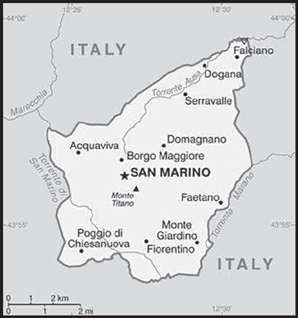
Background: Geographically the third-smallest state in Europe (after the Holy See and Monaco), San Marino also claims to be the world’s oldest republic. According to tradition, it was founded by a Christian stonemason named MARINUS in A.D. 301. San Marino’s foreign policy is aligned with that of the EU, although it is not a member; social and political trends in the republic track closely with those of its larger neighbor, Italy.
GEOGRAPHY
Location: Southern Europe, an enclave in central Italy
Geographic coordinates: 43 46 N, 12 25 E
Map references: Europe
Area: total: 61 sq km
land: 61 sq km
water: 0 sq km
comparison ranking: total 228
Area - comparative: about one-third the size of Washington, DC
Land boundaries: total: 37 km
border countries (1): Italy 37 km
Coastline: 0 km (landlocked)
Maritime claims: none (landlocked)
Climate: Mediterranean; mild to cool winters; warm, sunny summers
Terrain: rugged mountains
Elevation: highest point: Monte Titano 739 m
lowest point: Torrente Ausa 55 m
Natural resources: building stone
Land use: agricultural land: 16.7% (2018 est.)
arable land: 16.7% (2018 est.)
permanent crops: 0% (2018 est.)
permanent pasture: 0% (2018 est.)
forest: 0% (2018 est.)
other: 83.3% (2018 est.)
Irrigated land: 0 sq km (2022)
Natural hazards: occasional earthquakes
Geography - note: landlocked; an enclave of (completely surrounded by) Italy; smallest independent state in Europe after the Holy See and Monaco; dominated by the Apennine Mountains
PEOPLE AND SOCIETY
Population: 34,892 (2023 est.)
comparison ranking: 214
Nationality: noun: Sammarinese (singular and plural)
adjective: Sammarinese
Ethnic groups: Sammarinese, Italian
Languages: Italian
major-language sample(s):
L’Almanacco dei fatti del mondo, l’indispensabile fonte per le informazioni di base. (Italian)
religions: Roman Catholic
Age structure: 0-14 years: 14.34% (male 2,615/female 2,388)
15-64 years: 64.58% (male 10,906/female 11,628)
65 years and over: 21.08% (2023 est.) (male 3,329/female 4,026)
Dependency ratios: total dependency ratio: 49.6
youth dependency ratio: 19.6
elderly dependency ratio: 30
potential support ratio: 3.3 (2021)
Median age: total: 45.9 years (2023 est.)
male: 44.4 years
female: 47.2 years
comparison ranking: total 13
Population growth rate: 0.59% (2023 est.)
comparison ranking: 145
Birth rate: 8.9 births/1,000 population (2023 est.)
comparison ranking: 202
Death rate: 8.8 deaths/1,000 population (2023 est.)
comparison ranking: 65
Net migration rate: 5.9 migrant(s)/1,000 population (2023 est.)
comparison ranking: 20
Urbanization: urban population: 97.8% of total population (2023)
rate of urbanization: 0.41% annual rate of change (2020-25 est.)
Major urban areas - population: 4,000 SAN MARINO (2018)
Sex ratio: at birth: 1.09 male(s)/female
0-14 years: 1.1 male(s)/female
15-64 years: 0.94 male(s)/female
65 years and over: 0.83 male(s)/female
total population: 0.93 male(s)/female (2023 est.)
Mother’s mean age at first birth: 31.9 years (2019)
Infant mortality rate: total: 6.4 deaths/1,000 live births (2023 est.)
male: 7.5 deaths/1,000 live births
female: 5.1 deaths/1,000 live births
comparison ranking: total 166
Life expectancy at birth: total population: 84.1 years (2023 est.)
male: 81.5 years
female: 86.8 years
comparison ranking: total population 5
Total fertility rate: 1.53 children born/woman (2023 est.)
comparison ranking: 195
Gross reproduction rate: 0.73 (2023 est.)
Drinking water source: improved:
total: 100% of population
unimproved: total: 0% of population (2020)
Current health expenditure: 8.7% of GDP (2020)
Physicians density: 6.11 physicians/1,000 population (2014)
Hospital bed density: 3.8 beds/1,000 population (2012)
Sanitation facility access: improved:
total: 100% of population
unimproved: total: 0% of population (2020)
Currently married women (ages 15-49): 47.7% (2023 est.)
Education expenditures: 3.4% of GDP (2020 est.)
comparison ranking: 143
Literacy: total population: 99.9%
male: 99.9%
female: 99.9% (2018)
School life expectancy (primary to tertiary education): total: 12 years
male: 13 years
female: 12 years (2021)
Youth unemployment rate (ages 15-24): total: 27.4% (2016 est.)
male: 21.4%
female: 36%
comparison ranking: total 48
ENVIRONMENT
Environment - current issues: air pollution; urbanization decreasing rural farmlands; water shortage
Environment - international agreements: party to: Biodiversity, Climate Change, Climate Change-Kyoto Protocol, Climate Change-Paris Agreement, Comprehensive Nuclear Test Ban, Desertification, Endangered Species, Nuclear Test Ban, Ozone Layer Protection, Whaling
signed, but not ratified: Air Pollution
Climate: Mediterranean; mild to cool winters; warm, sunny summers
Land use: agricultural land: 16.7% (2018 est.)
arable land: 16.7% (2018 est.)
permanent crops: 0% (2018 est.)
permanent pasture: 0% (2018 est.)
forest: 0% (2018 est.)
other: 83.3% (2018 est.)
Urbanization: urban population: 97.8% of total population (2023)
rate of urbanization: 0.41% annual rate of change (2020-25 est.)
Revenue from forest resources: 0% of GDP (2018 est.)
comparison ranking: 170
Air pollutants: particulate matter emissions: 9.85 micrograms per cubic meter (2019 est.)
methane emissions: 0.02 megatons (2020 est.)
Waste and recycling: municipal solid waste generated annually: 17,175 tons (2016 est.)
municipal solid waste recycled annually: 7,737 tons (2016 est.)
percent of municipal solid waste recycled: 45.1% (2016 est.)
GOVERNMENT
Country name: conventional long form: Republic of San Marino
conventional short form: San Marino
local long form: Repubblica di San Marino
local short form: San Marino
etymology: named after Saint MARINUS, who in A.D. 301 founded the monastic settlement around which the city and later the state of San Marino coalesced
Government type: parliamentary republic
Capital: name: San Marino (city)
geographic coordinates: 43 56 N, 12 25 E
time difference: UTC+1 (6 hours ahead of Washington, DC, during Standard Time)
daylight saving time: +1hr, begins last Sunday in March; ends last Sunday in October
etymology: named after Saint MARINUS, who in A.D. 301 founded a monastic settlement around which the city and later the state of San Marino coalesced
Administrative divisions: 9 municipalities (castelli, singular - castello); Acquaviva, Borgo Maggiore, Chiesanuova, Domagnano, Faetano, Fiorentino, Montegiardino, San Marino Citta, Serravalle
Independence: 3 September 301 (traditional founding date)
National holiday: Founding of the Republic (or Feast of Saint Marinus), 3 September (A.D. 301)
Constitution: history: San Marino’s principal legislative instruments consist of old customs (antiche consuetudini), the Statutory Laws of San Marino (Leges Statutae Sancti Marini), old statutes (antichi statute) from the1600s, Brief Notes on the Constitutional Order and Institutional Organs of the Republic of San Marino (Brevi Cenni sull’Ordinamento Costituzionale e gli Organi Istituzionali della Repubblica di San Marino) and successive legislation, chief among them is the Declaration of the Rights of Citizens and Fundamental Principles of the San Marino Legal Order (Dichiarazione dei Diritti dei Cittadini e dei Principi Fondamentali dell’Ordinamento Sammarinese), approved 8 July 1974
amendments: proposed by the Great and General Council; passage requires two-thirds majority Council vote; Council passage by absolute majority vote also requires passage in a referendum; Declaration of Civil Rights amended several times, last in 2019
Legal system: civil law system with Italian civil law influences
International law organization participation: has not submitted an ICJ jurisdiction declaration; accepts ICCt jurisdiction
Citizenship: citizenship by birth: no
citizenship by descent only: at least one parent must be a citizen of San Marino
dual citizenship recognized: no
residency requirement for naturalization: 30 years
Suffrage: 18 years of age; universal
Executive branch: chief of state: co-chiefs of state Captain Regent Alessandro SCARANO and Adele TONNINI (for the period 1 April 2023 - 1 October 2023)
head of government: Secretary of State for Foreign and Political Affairs Luca BECCARI (since 8 January 2020)
cabinet: Congress of State elected by the Grand and General Council
elections/appointments: co-chiefs of state (captains regent) indirectly elected by the Grand and General Council for a single 6-month term; election last held in March 2023; secretary of state for foreign and political affairs indirectly elected by the Grand and General Council for a single 5-year term; election last held on 28 December 2019 (next to be held by November 2024)
election results: Alessandro SCARANO and Adele TONNINI elected captains regent; percent of Grand and General Council vote - NA; Luca BECCARI (PDCS) elected secretary of state for foreign and political affairs; percent of Grand and General Council vote - NA
note: the captains regent preside over meetings of the Grand and General Council and its cabinet (Congress of State), which has 7 other members who are selected by the Grand and General Council; assisting the captains regent are 7 secretaries of state; the secretary of state for Foreign Affairs has some prime ministerial roles
Legislative branch: description: unicameral Grand and General Council or Consiglio Grande e Generale (60 seats; members directly elected in single- and multi-seat constituencies by list proportional representation vote in 2 rounds if needed; members serve 5-year terms)
elections: last held on 8 December 2019 (next to be held by 31 December 2024)
election results: percent of vote by coalition/party - PDCS 35%, Tomorrow in Movement coalition 25% (RETE Movement 18.3%, DML 6.7%), Liberia 16.7%, We for the Republic 13.3%, RF 10%; seats by coalition/party - PDCS 21, Tomorrow in Movement coalition 15 (RETE Movement 11, DML 4), Liberia 10, We for the Republic 8, RF 6; composition (as of September 2022) - men 40, women 20, percent of women 33.3%
Judicial branch: highest court(s): Council of Twelve or Consiglio dei XII (consists of 12 members); note - the College of Guarantors for the Constitutionality and General Norms functions as San Marino’s constitutional court
judge selection and term of office: judges elected by the Grand and General Council from among its own to serve 5-year terms
subordinate courts: first instance and first appeal criminal, administrative, and civil courts; Court for the Trust and Trustee Relations; justices of the peace or conciliatory judges
Political parties and leaders: Domani - Modus Liberi or DML [Lorenzo Forcellini REFFI]
Free San Marino (Libera San Marino) or Libera [Luca BOSCHI]
Future Republic or RF [Mario VENTURINI]
I Elect for a New Republic
Party of Socialists and Democrats or PSD [Paride ANDREOLI]
RETE Movement [Gloria ARCANGELONI]
Sammarinese Christian Democratic Party or PDCS [Marco GATTI]
Socialist Party or PS [Alessandro BEVITORI]
Tomorrow in Movement coalition (includes RETE Movement, DML)
We for the Republic [Denise BRONZETTI]
International organization participation: CE, FAO, IAEA, IBRD, ICAO, ICC (NGOs), ICCt, ICRM, IDA, IFRCS, ILO, IMF, IMO, Interpol, IOC, IOM (observer), IPU, ITU, ITUC (NGOs), LAIA (observer), OPCW, OSCE, Schengen Convention (de facto member), UN, UNCTAD, UNESCO, Union Latina, UNWTO, UPU, WHO, WIPO
Diplomatic representation in the US: chief of mission: Ambassador Damiano BELEFFI (since 21 July 2017)
chancery: 327 E 50th Street, New York, NY 10022
telephone: [1] (212) 751-1234
FAX: [1] (212) 751-1436
email address and website:
Republic of San Marino Permanent Mission to the United Nations
Diplomatic representation from the US: chief of mission: Ambassador Jack Markell (since September 2023); note - also accredited to Italy
embassy: the United States does not have an Embassy in San Marino; the US Ambassador to Italy is accredited to San Marino, and the US Consulate General in Florence maintains day-to-day ties
Flag description: two equal horizontal bands of white (top) and light blue with the national coat of arms superimposed in the center; the main colors derive from the shield of the coat of arms, which features three white towers on three peaks on a blue field; the towers represent three castles built on San Marino’s highest feature, Mount Titano: Guaita, Cesta, and Montale; the coat of arms is flanked by a wreath, below a crown and above a scroll bearing the word LIBERTAS (Liberty); the white and blue colors are also said to stand for peace and liberty respectively
National symbol(s): three peaks each displaying a tower; national colors: white, blue
National anthem: name: “Inno Nazionale della Repubblica” (National Anthem of the Republic)
lyrics/music: no lyrics/Federico CONSOLO
note: adopted 1894; the music for the lyric-less anthem is based on a 10th century chorale piece
National heritage: total World Heritage Sites: 1 (cultural)
selected World Heritage Site locales: San Marino Historic Center and Mount Titano
ECONOMY
Economic overview: high-income, non-EU European economy; surrounded by Italy, which is the dominant importer and exporter; open border to EU and a euro user; strong financial sector; high foreign investments; low taxation; increasingly high and risky debt
Real GDP (purchasing power parity): $1.917 billion (2020 est.)
$2.053 billion (2019 est.)
$2.012 billion (2018 est.)
note: data are in 2017 dollars
comparison ranking: 198
Real GDP growth rate: -6.65% (2020 est.)
2.07% (2019 est.)
1.49% (2018 est.)
comparison ranking: 215
Real GDP per capita: $56,400 (2020 est.) note: data are in 2017 dollars
$60,100 (2019 est.) note: data are in 2017 dollars
$58,900 (2018 est.)
comparison ranking: 22
GDP (official exchange rate): $1.643 billion (2017 est.)
Inflation rate (consumer prices): 1.05% (2017 est.)
0.6% (2016 est.)
comparison ranking: 197
Credit ratings: Fitch rating: BB+ (2020)
note: The year refers to the year in which the current credit rating was first obtained.
GDP - composition, by sector of origin: agriculture: 0.1% (2009)
industry: 39.2% (2009)
services: 60.7% (2009)
comparison rankings: services 120; industry 35; agriculture 220
GDP - composition, by end use: exports of goods and services: 176.6% (2011)
imports of goods and services: -153.3% (2011)
Agricultural products: wheat, grapes, corn, olives; cattle, pigs, horses, beef, cheese, hides
Industries: tourism, banking, textiles, electronics, ceramics, cement, wine
Industrial production growth rate: -1.1% (2012 est.)
comparison ranking: 170
Labor force: 21,960 (September 2013 est.)
comparison ranking: 211
Labor force - by occupation: agriculture: 0.2%
industry: 33.5%
services: 66.3% (September 2013 est.)
Unemployment rate: 8.1% (2017 est.)
8.6% (2016 est.)
comparison ranking: 93
Youth unemployment rate (ages 15-24): total: 27.4% (2016 est.)
male: 21.4%
female: 36%
comparison ranking: total 48
Budget: revenues: $371 million (2019 est.)
expenditures: $363 million (2019 est.)
Budget surplus (+) or deficit (-): -2.9% (of GDP) (2011 est.)
comparison ranking: 129
Public debt: 98.35% of GDP (2020 est.)
55.09% of GDP (2019 est.)
55.94% of GDP (2018 est.)
comparison ranking: 27
Taxes and other revenues: 16.14% (of GDP) (2020 est.)
comparison ranking: 134
Fiscal year: calendar year
Current account balance: $0 (2017 est.)
$0 (2016 est.)
comparison ranking: 77
Exports: $3.827 billion (2011 est.)
$2.576 billion (2010 est.)
comparison ranking: 138
Exports - partners: Romania 10%, France 9%, Germany 8%, United States 8%, Austria 6%, Brazil 6%, Poland 6%, Russia 6%, (2019)
Exports - commodities: industrial washing/bottling machinery, packaged medicines, woodworking machinery, foodstuffs, aircraft (2019)
Imports: $2.551 billion (2011 est.)
$2.132 billion (2010 est.)
comparison ranking: 162
Imports - partners: Germany 21%, Italy 13%, Poland 10%, France 7%, Spain 7%, Belgium 6%, Romania 6% (2019)
Imports - commodities: electricity, cars, aluminum, footwear, natural gas, iron piping (2019)
Reserves of foreign exchange and gold: $954.512 million (31 December 2021 est.)
$781.805 million (31 December 2020 est.)
$473.111 million (31 December 2019 est.)
comparison ranking: 147
Exchange rates: euros (EUR) per US dollar -
Exchange rates: 0.845 (2021 est.)
0.877 (2020 est.)
0.893 (2019 est.)
0.847 (2018 est.)
0.885 (2017 est.)
note: while not an EU member state, San Marino, due to its preexisting monetary and banking agreements with Italy, has a 2000 monetary agreement with the EU to produce limited euro coinage—but not banknotes—that began enforcement in January 2002 and was superseded by a new EU agreement in 2012
ENERGY
Electricity access: electrification - total population: 100% (2021)
COMMUNICATIONS
Telephones - fixed lines: total subscriptions: 16,000 (2021 est.)
subscriptions per 100 inhabitants: 47 (2021 est.)
comparison ranking: total subscriptions 178
Telephones - mobile cellular: total subscriptions: 40,000 (2021 est.)
subscriptions per 100 inhabitants: 119 (2021 est.)
comparison ranking: total subscriptions 208
Telecommunication systems: general assessment: automatic telephone system completely integrated into Italian system (2018)
domestic: fixed-line is 47 per 100 and mobile-cellular teledensity is 119 telephones per 100 persons (2021)
international: country code - 378; connected to Italian international network
Broadcast media: state-owned public broadcaster operates 1 TV station and 3 radio stations; receives radio and TV broadcasts from Italy (2019)
Internet country code: .sm
Internet users: total: 25,500 (2021 est.)
percent of population: 75% (2021 est.)
comparison ranking: total 210
Broadband - fixed subscriptions: total: 11,000 (2020 est.)
subscriptions per 100 inhabitants: 32 (2020 est.)
comparison ranking: total 179
TRANSPORTATION
Civil aircraft registration country code prefix: T7
Roadways: total: 292 km (2006)
paved: 292 km (2006)
comparison ranking: total 203
MILITARY AND SECURITY
Military and security forces: Military Corps (National Guard): Guard of the Rock (or Fortress Guard), Uniformed Militia, Guard of the Great and General Council, Corps of the Gendarmerie
Ministry of Internal Affairs: Civil Police Corps (2023)
note: the captains regent oversees the Gendarmerie and National Guard when they are performing duties related to public order and security; the Ministry of Foreign Affairs exercises control over such administrative functions as personnel and equipment, and the courts exercise control over the Gendarmerie when it acts as judicial police
Military service age and obligation: 18 is the legal minimum age for voluntary military service; no conscription; government has the authority to call up all San Marino citizens from 16-60 years of age to serve in the military (2023)
Military - note: defense is the responsibility of Italy
TRANSNATIONAL ISSUES
Disputes - international: none identified
SAO TOME AND PRINCIPE
INTRODUCTION
Background: Portugal discovered and colonized the uninhabited islands in the late 15th century, setting up a sugar-based economy that gave way to coffee and cocoa in the 19th century - all grown with African plantation slave labor, a form of which lingered into the 20th century. While independence was achieved in 1975, democratic reforms were not instituted until the late 1980s. The country held its first free elections in 1991, but frequent internal wrangling between the various political parties precipitated repeated changes in leadership and five failed, non-violent coup attempts in 1995, 1998, 2003, 2009, and 2022. In 2012, three opposition parties combined in a no confidence vote to bring down the majority government of former Prime Minister Patrice TROVOADA, but in 2014, legislative elections returned him to the office. President Evaristo CARVALHO, of the same political party as Prime Minister TROVOADA, was elected in September 2016, marking a rare instance in which the positions of president and prime minister were held by the same party. Prime Minister TROVOADA resigned at the end of 2018 and was replaced by Jorge BOM JESUS. Carlos Vila NOVA was elected president in September 2021 and was inaugurated early the following month. TROVOADA began his fourth stint as prime minister in November 2022, following his party’s victory in legislative elections held in September of that year. New oil discoveries in the Gulf of Guinea may attract increased attention to the small island nation.
GEOGRAPHY
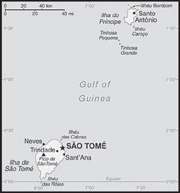
Location: Central Africa, islands in the Gulf of Guinea, just north of the Equator, west of Gabon
Geographic coordinates: 1 00 N, 7 00 E
Map references: Africa
Area: total: 964 sq km
land: 964 sq km
water: 0 sq km
comparison ranking: total 184
Area - comparative: more than five times the size of Washington, DC
Land boundaries: total: 0 km
Coastline: 209 km
Maritime claims: territorial sea: 12 nm
exclusive economic zone: 200 nm
measured from claimed archipelagic baselines
Climate: tropical; hot, humid; one rainy season (October to May)
Terrain: volcanic, mountainous
Elevation: highest point: Pico de Sao Tome 2,024 m
lowest point: Atlantic Ocean 0 m
Natural resources: fish, hydropower
Land use: agricultural land: 50.7% (2018 est.)
arable land: 9.1% (2018 est.)
permanent crops: 40.6% (2018 est.)
permanent pasture: 1% (2018 est.)
forest: 28.1% (2018 est.)
other: 21.2% (2018 est.)
Irrigated land: 100 sq km (2012)
Population distribution: Sao Tome, the capital city, has roughly a quarter of the nation’s population; Santo Antonio is the largest town on Principe; the northern areas of both islands have the highest population densities as shown in this population distribution map
Natural hazards: flooding
Geography - note: the second-smallest African country (after the Seychelles); the two main islands form part of a chain of extinct volcanoes and both are mountainous
PEOPLE AND SOCIETY
Population: 220,372 (2023 est.)
comparison ranking: 183
Nationality: noun: Sao Tomean(s)
adjective: Sao Tomean
Ethnic groups: Mestico, Angolares (descendants of Angolan slaves), Forros (descendants of freed slaves), Servicais (contract laborers from Angola, Mozambique, and Cabo Verde), Tongas (children of servicais born on the islands), Europeans (primarily Portuguese), Asians (mostly Chinese)
Languages: Portuguese 98.4% (official), Forro 36.2%, Cabo Verdian 8.5%, French 6.8%, Angolar 6.6%, English 4.9%, Lunguie 1%, other (including sign language) 2.4%; note - shares sum to more than 100% because some respondents gave more than one answer on the census; other Portuguese-based Creoles are also spoken (2012 est.)
Religions: Catholic 55.7%, Adventist 4.1%, Assembly of God 3.4%, New Apostolic 2.9%, Mana 2.3%, Universal Kingdom of God 2%, Jehovah’s Witness 1.2%, other 6.2%, none 21.2%, unspecified 1% (2012 est.)
Demographic profile: Sao Tome and Principe’s youthful age structure – more than 60% of the population is under the age of 25 as of 2020 – and high fertility rate ensure future population growth. Although Sao Tome has a net negative international migration rate, emigration is not a sufficient safety valve to reduce already high levels of unemployment and poverty. While literacy and primary school attendance have improved in recent years, Sao Tome still struggles to improve its educational quality and to increase its secondary school completion rate. Despite some improvements in education and access to healthcare, Sao Tome and Principe has much to do to decrease its high poverty rate, create jobs, and increase its economic growth.
The population of Sao Tome and Principe descends primarily from the islands’ colonial Portuguese settlers, who first arrived in the late 15th century, and the much larger number of African slaves brought in for sugar production and the slave trade. For about 100 years after the abolition of slavery in 1876, the population was further shaped by the widespread use of imported unskilled contract laborers from Portugal’s other African colonies, who worked on coffee and cocoa plantations. In the first decades after abolition, most workers were brought from Angola under a system similar to slavery. While Angolan laborers were technically free, they were forced or coerced into long contracts that were automatically renewed and extended to their children. Other contract workers from Mozambique and famine-stricken Cape Verde first arrived in the early 20th century under short-term contracts and had the option of repatriation, although some chose to remain in Sao Tome and Principe.
Today’s Sao Tomean population consists of mesticos (creole descendants of the European immigrants and African slaves that first inhabited the islands), forros (descendants of freed African slaves), angolares (descendants of runaway African slaves that formed a community in the south of Sao Tome Island and today are fishermen), servicais (contract laborers from Angola, Mozambique, and Cape Verde), tongas (locally born children of contract laborers), and lesser numbers of Europeans and Asians.
Age structure: 0-14 years: 37.21% (male 41,620/female 40,373)
15-64 years: 59.64% (male 65,356/female 66,078)
65 years and over: 3.15% (2023 est.) (male 2,986/female 3,959)
Dependency ratios: total dependency ratio: 77.9
youth dependency ratio: 71.2
elderly dependency ratio: 6.7
potential support ratio: 14.9 (2021 est.)
Median age: total: 20.4 years (2023 est.)
male: 20 years
female: 20.8 years
comparison ranking: total 198
Population growth rate: 1.45% (2023 est.)
comparison ranking: 70
Birth rate: 27.4 births/1,000 population (2023 est.)
comparison ranking: 39
Death rate: 6.1 deaths/1,000 population (2023 est.)
comparison ranking: 153
Net migration rate: -6.8 migrant(s)/1,000 population (2023 est.)
comparison ranking: 214
Population distribution: Sao Tome, the capital city, has roughly a quarter of the nation’s population; Santo Antonio is the largest town on Principe; the northern areas of both islands have the highest population densities as shown in this population distribution map
Urbanization: urban population: 76.4% of total population (2023)
rate of urbanization: 2.96% annual rate of change (2020-25 est.)
Major urban areas - population: 80,000 SAO TOME (capital) (2018)
Sex ratio: at birth: 1.03 male(s)/female
0-14 years: 1.03 male(s)/female
15-64 years: 0.99 male(s)/female
65 years and over: 0.75 male(s)/female
total population: 1 male(s)/female (2023 est.)
Mother’s mean age at first birth: 19.4 years (2008/09 est.)
note: data represents median age at first birth among women 25-29
Maternal mortality ratio: 146 deaths/100,000 live births (2020 est.)
comparison ranking: 55
Infant mortality rate: total: 43.5 deaths/1,000 live births (2023 est.)
male: 46.9 deaths/1,000 live births
female: 39.9 deaths/1,000 live births
comparison ranking: total 27
Life expectancy at birth: total population: 67.4 years (2023 est.)
male: 65.7 years
female: 69.1 years
comparison ranking: total population 195
Total fertility rate: 3.44 children born/woman (2023 est.)
comparison ranking: 40
Gross reproduction rate: 1.69 (2023 est.)
Contraceptive prevalence rate: 49.7% (2019)
Drinking water source: improved: urban: 100% of population
rural: 94% of population
total: 98.5% of population
unimproved: urban: 0% of population
rural: 6% of population
total: 1.5% of population (2020 est.)
Current health expenditure: 4.9% of GDP (2020)
Physicians density: 0.49 physicians/1,000 population (2019)
Hospital bed density: 2.9 beds/1,000 population (2011)
Sanitation facility access: improved: urban: 57.1% of population
rural: 42.8% of population
total: 53.4% of population
unimproved: urban: 42.9% of population
rural: 57.2% of population
total: 46.6% of population (2020 est.)
Major infectious diseases: degree of risk: high (2023)
food or waterborne diseases: bacterial diarrhea, hepatitis A, and typhoid fever
vectorborne diseases: malaria and dengue fever
water contact diseases: schistosomiasis
Obesity - adult prevalence rate: 12.4% (2016)
comparison ranking: 133
Alcohol consumption per capita: total: 4.23 liters of pure alcohol (2019 est.)
beer: 0.42 liters of pure alcohol (2019 est.)
wine: 3.58 liters of pure alcohol (2019 est.)
spirits: 0.23 liters of pure alcohol (2019 est.)
other alcohols: 0 liters of pure alcohol (2019 est.)
comparison ranking: total 92
Tobacco use: total: 5.7% (2020 est.)
male: 10.1% (2020 est.)
female: 1.3% (2020 est.)
comparison ranking: total 159
Children under the age of 5 years underweight: 5.4% (2019)
comparison ranking: 72
Currently married women (ages 15-49): 51.9% (2023 est.)
Child marriage: women married by age 15: 5.4%
women married by age 18: 28%
men married by age 18: 3.1% (2019 est.)
Education expenditures: 5% of GDP (2020 est.)
comparison ranking: 73
Literacy: definition: age 15 and over can read and write
total population: 94.8%
male: 96.5%
female: 91.1% (2021)
School life expectancy (primary to tertiary education): total: 12 years
male: 12 years
female: 13 years (2015)
Youth unemployment rate (ages 15-24): total: 22.9% (2021 est.)
male: 18%
female: 34.3%
comparison ranking: total 71
ENVIRONMENT
Environment - current issues: deforestation and illegal logging; soil erosion and exhaustion; inadequate sewage treatment in cities; biodiversity preservation
Environment - international agreements: party to: Biodiversity, Climate Change, Climate Change-Kyoto Protocol, Climate Change-Paris Agreement, Desertification, Endangered Species, Environmental Modification, Hazardous Wastes, Law of the Sea, Ozone Layer Protection, Ship Pollution, Wetlands, Whaling
signed, but not ratified: Comprehensive Nuclear Test Ban
Climate: tropical; hot, humid; one rainy season (October to May)
Land use: agricultural land: 50.7% (2018 est.)
arable land: 9.1% (2018 est.)
permanent crops: 40.6% (2018 est.)
permanent pasture: 1% (2018 est.)
forest: 28.1% (2018 est.)
other: 21.2% (2018 est.)
Urbanization: urban population: 76.4% of total population (2023)
rate of urbanization: 2.96% annual rate of change (2020-25 est.)
Revenue from forest resources: 1.9% of GDP (2018 est.)
comparison ranking: 36
Revenue from coal: 0% of GDP (2018 est.)
comparison ranking: 110
Air pollutants: particulate matter emissions: 33.75 micrograms per cubic meter (2019 est.)
carbon dioxide emissions: 0.12 megatons (2016 est.)
methane emissions: 0.04 megatons (2020 est.)
Waste and recycling: municipal solid waste generated annually: 25,587 tons (2014 est.)
Total water withdrawal: municipal: 10 million cubic meters (2020 est.)
industrial: 600,000 cubic meters (2017 est.)
agricultural: 30 million cubic meters (2020 est.)
Total renewable water resources: 2.18 billion cubic meters (2020 est.)
GOVERNMENT
Country name: conventional long form: Democratic Republic of Sao Tome and Principe
conventional short form: Sao Tome and Principe
local long form: Republica Democratica de Sao Tome e Principe
local short form: Sao Tome e Principe
etymology: Sao Tome was named after Saint THOMAS the Apostle by the Portuguese who discovered the island on 21 December 1470 (or 1471), the saint’s feast day; Principe is a shortening of the original Portuguese name of “Ilha do Principe” (Isle of the Prince) referring to the Prince of Portugal to whom duties on the island’s sugar crop were paid
Government type: semi-presidential republic
Capital: name: Sao Tome
geographic coordinates: 0 20 N, 6 44 E
time difference: UTC 0 (5 hours ahead of Washington, DC, during Standard Time)
etymology: named after Saint Thomas the Apostle
Administrative divisions: 6 districts (distritos, singular - distrito), 1 autonomous region* (regiao autonoma); Agua Grande, Cantagalo, Caue, Lemba, Lobata, Me-Zochi, Principe*
Independence: 12 July 1975 (from Portugal)
National holiday: Independence Day, 12 July (1975)
Constitution: history: approved 5 November 1975
amendments: proposed by the National Assembly; passage requires two-thirds majority vote by the Assembly; the Assembly can propose to the president of the republic that an amendment be submitted to a referendum; revised several times, last in 2006
Legal system: mixed legal system of civil law based on the Portuguese model and customary law
International law organization participation: has not submitted an ICJ jurisdiction declaration; non-party state to the ICCt
Citizenship: citizenship by birth: no
citizenship by descent only: at least one parent must be a citizen of Sao Tome and Principe
dual citizenship recognized: no
residency requirement for naturalization: 5 years
Suffrage: 18 years of age; universal
Executive branch: chief of state: President Carlos Manuel VILA NOVA (since 2 October 2021)
head of government: Prime Minister Patrice TROVOADA (since 11 November 2022)
cabinet: Council of Ministers proposed by the prime minister, appointed by the president
elections/appointments: president directly elected by absolute majority popular vote in 2 rounds if needed for a 5-year term (eligible for a second term); election last held on 18 July 2021 and runoff on 5 September 2021 (next to be held in 2026); prime minister chosen by the National Assembly and approved by the president
election results:
2021: Carlos Manuel VILA NOVA elected president in the second round; percent of vote in the first round - Carlos Manuel VILA NOVA (IDA) 39.5%; Guilherme POSSER DA COSTA (MLSTP-PSD) 20.8%; Delfim NEVES (PCD-GR) 16.9%; Abel BOM JESUS (independent) 3.6%; Maria DAS NEVES (independent) 3.3%; other 15.9%; percent of the vote in second round - Carlos Manuel VILA NOVA 57.5%, Guilherme POSSER DA COSTA 42.5%
2016: Evaristo CARVALHO elected president; percent of vote - Evaristo CARVALHO (ADI) 49.8%, Manuel Pinto DA COSTA (independent) 24.8%, Maria DAS NEVES (MLSTP-PSD) 24.1%; note - first round results for CARVALHO were revised downward from just over 50%, prompting the 7 August runoff; however, on 1 August 2016 DA COSTA withdrew from the runoff, citing voting irregularities, and Evaristo CARVALHO was declared the winner
Legislative branch: description: unicameral National Assembly or Assembleia Nacional (55 seats; members directly elected in multi-seat constituencies by closed party-list proportional representation vote to serve 4-year terms)
elections: last held on 25 September 2022 (next to be held 30 September 2026)
election results: percent of vote by party - ADI 46.81%, MLSTP/PSD 32.70%, MCI-PS -PUN 6.56%, BASTA Movement- 8.8%, other 5.14%; seats by party - ADI 30, MLSTP-PSD 18, MCI-PS -PUN 5, BASTA Movement 2; composition - men 47, women 8, percent of women 14.5%
Judicial branch: highest court(s): Supreme Court or Supremo Tribunal Justica (consists of 5 judges); Constitutional Court or Tribunal Constitucional (consists of 5 judges, 3 of whom are from the Supreme Court)
judge selection and term of office: Supreme Court judges appointed by the National Assembly; judge tenure NA; Constitutional Court judges nominated by the president and elected by the National Assembly for 5-year terms
subordinate courts: Court of First Instance; Audit Court
Political parties and leaders: Union of Democrats for Citizenship and Development and Force for Democratic Change Movement or MDFM–UDD
[Carlos Filomeno Agostinho DAS NEVES]
Independent Democratic Action or ADI [Patrice TROVADA]
Movement for the Liberation of Sao Tome and Principe-Social Democratic Party or MLSTP-PSD [Jorge Lopes Bom JESUS]
Party for Democratic Convergence-Reflection Group or PCD-GR [Leonel Mario D’ALVA]
Movement of Independent Citizens of São Tomé and Príncipe [António Monteiro]
other small parties
International organization participation: ACP, AfDB, AOSIS, AU, CD, CEMAC, CPLP, EITI (candidate country), FAO, G-77, IBRD, ICAO, ICRM, IDA, IFAD, IFC, IFRCS, ILO, IMF, IMO, Interpol, IOC, IOM (observer), IPU, ITU, ITUC (NGOs), MIGA, NAM, OIF, OPCW, PCA, UN, UNCTAD, UNESCO, UNIDO, Union Latina, UNWTO, UPU, WCO, WHO, WIPO, WMO, WTO (observer)
Diplomatic representation in the US: chief of mission: Ambassador (vacant)
chancery: 122 East 42nd Street, Suite 1604
New York, NY 101168
telephone: [1] (212) 317-0533
FAX: [1] (212) 317-0580
email address and website:
Sao Tome and Principe Permanent Mission to the United Nations
Diplomatic representation from the US: embassy: the US does not have an embassy in Sao Tome and Principe; the US Ambassador to Gabon is accredited to Sao Tome and Principe
mailing address: 2290 Sao Tome Place, Washington DC 20521-2290
Flag description: three horizontal bands of green (top), yellow (double width), and green with two black five-pointed stars placed side by side in the center of the yellow band and a red isosceles triangle based on the hoist side; green stands for the country’s rich vegetation, red recalls the struggle for independence, and yellow represents cocoa, one of the country’s main agricultural products; the two stars symbolize the two main islands
note: uses the popular Pan-African colors of Ethiopia
National symbol(s): palm tree; national colors: green, yellow, red, black
National anthem: name: “Independencia total” (Total Independence)
lyrics/music: Alda Neves DA GRACA do Espirito Santo/Manuel dos Santos Barreto de Sousa e ALMEIDA
note: adopted 1975
ECONOMY
Economic overview: ower middle-income Central African island economy; falling cocoa production due to drought and mismanagement; joint oil venture with Nigeria; government owns 90% of land; high debt, partly from fuel subsidies; tourism gutted by COVID-19
Real GDP (purchasing power parity): $904.057 million (2021 est.)
$887.393 million (2020 est.)
$861.341 million (2019 est.)
note: data are in 2017 dollars
comparison ranking: 207
Real GDP growth rate: 1.88% (2021 est.)
3.02% (2020 est.)
2.21% (2019 est.)
comparison ranking: 166
Real GDP per capita: $4,100 (2021 est.)
$4,100 (2020 est.)
$4,000 (2019 est.)
note: data are in 2017 dollars
comparison ranking: 183
GDP (official exchange rate): $0 (2018 est.)
Inflation rate (consumer prices): 7.86% (2018 est.)
5.7% (2017 est.)
5.6% (2017 est.)
comparison ranking: 37
GDP - composition, by sector of origin: agriculture: 11.8% (2017 est.)
industry: 14.8% (2017 est.)
services: 73.4% (2017 est.)
comparison rankings: services 57; industry 183; agriculture 81
GDP - composition, by end use: household consumption: 81.4% (2017 est.)
government consumption: 17.6% (2017 est.)
investment in fixed capital: 33.4% (2017 est.)
investment in inventories: 0% (2017 est.)
exports of goods and services: 7.9% (2017 est.)
imports of goods and services: -40.4% (2017 est.)
Agricultural products: plantains, oil palm fruit, coconuts, taro, bananas, fruit, cocoa, yams, cassava, maize
Industries: light construction, textiles, soap, beer, fish processing, timber
Industrial production growth rate: 1.44% (2021 est.)
comparison ranking: 142
Labor force: 71,400 (2021 est.)
comparison ranking: 188
Labor force - by occupation: agriculture: 26.1%
industry: 21.4%
services: 52.5% (2014 est.)
Unemployment rate: 15.91% (2021 est.)
15.75% (2020 est.)
14.14% (2019 est.)
comparison ranking: 32
Youth unemployment rate (ages 15-24): total: 22.9% (2021 est.)
male: 18%
female: 34.3%
comparison ranking: total 71
Population below poverty line: 66.7% (2017 est.)
Gini Index coefficient - distribution of family income: 40.7 (2017 est.)
comparison ranking: 53
Budget: revenues: $95 million (2019 est.)
expenditures: $102 million (2019 est.)
Budget surplus (+) or deficit (-): -2.4% (of GDP) (2017 est.)
comparison ranking: 111
Public debt: 88.4% of GDP (2017 est.)
93.1% of GDP (2016 est.)
comparison ranking: 34
Taxes and other revenues: 26.2% (of GDP) (2017 est.)
comparison ranking: 43
Fiscal year: calendar year
Current account balance: -$95.248 million (2021 est.)
-$59.595 million (2020 est.)
-$90.026 million (2019 est.)
comparison ranking: 92
Exports: $75.256 million (2021 est.) note: data are in current year dollars
$49.337 million (2020 est.) note: data are in current year dollars
$72.594 million (2019 est.) note: data are in current year dollars
comparison ranking: 212
Exports - partners: Singapore 30%, Switzerland 24%, France 11%, Poland 7%, Belgium 7%, United States 5% (2019)
Exports - commodities: gas turbines, cocoa beans, aircraft parts, iron products, chocolate (2019)
Imports: $201.145 million (2021 est.) note: data are in current year dollars
$160.097 million (2020 est.) note: data are in current year dollars
$189.63 million (2019 est.) note: data are in current year dollars
comparison ranking: 212
Imports - partners: Portugal 41%, Angola 17%, China 8% (2019)
Imports - commodities: refined petroleum, cars, rice, flavored water, postage stamps (2019)
Reserves of foreign exchange and gold: $75.288 million (31 December 2020 est.)
$47.148 million (31 December 2019 est.)
$43.684 million (31 December 2018 est.)
comparison ranking: 190
Debt - external: $292.9 million (31 December 2017 est.)
$308.5 million (31 December 2016 est.)
comparison ranking: 184
Exchange rates: dobras (STD) per US dollar -
Exchange rates: 21.507 (2020 est.)
21.885 (2019 est.)
20.751 (2018 est.)
21.741 (2017 est.)
22.149 (2016 est.)
ENERGY
Electricity access: population without electricity: (2020) less than 1 million
electrification - total population: 78.4% (2021)
electrification - urban areas: 80% (2021)
electrification - rural areas: 73.7% (2021)
Electricity: installed generating capacity: 28,000 kW (2020 est.)
consumption: 78 million kWh (2019 est.)
exports: 0 kWh (2020 est.)
imports: 0 kWh (2020 est.)
transmission/distribution losses: 11.9 million kWh (2019 est.)
comparison rankings: imports 125; exports 105; installed generating capacity 201; transmission/distribution losses 193; consumption 198
Electricity generation sources: fossil fuels: 89.5% of total installed capacity (2020 est.)
hydroelectricity: 10.5% of total installed capacity (2020 est.)
Petroleum: total petroleum production: 0 bbl/day (2021 est.)
refined petroleum consumption: 1,200 bbl/day (2019 est.)
Refined petroleum products - imports: 1,027 bbl/day (2015 est.)
comparison ranking: 201
Carbon dioxide emissions: 173,000 metric tonnes of CO2 (2019 est.)
from petroleum and other liquids: 173,000 metric tonnes of CO2 (2019 est.)
comparison ranking: total emissions 206
Energy consumption per capita: 11.636 million Btu/person (2019 est.)
comparison ranking: 148
COMMUNICATIONS
Telephones - fixed lines: total subscriptions: 2,619 (2021 est.)
subscriptions per 100 inhabitants: 1 (2021 est.)
comparison ranking: total subscriptions 213
Telephones - mobile cellular: total subscriptions: 189,239 (2021 est.)
subscriptions per 100 inhabitants: 85 (2021 est.)
comparison ranking: total subscriptions 183
Telecommunication systems: general assessment: local telephone network of adequate quality with most lines connected to digital switches; mobile cellular superior choice to landland; dial-up quality low; broadband expensive (2018)
domestic: fixed-line is 1 per 100 and mobile-cellular teledensity is 85 telephones per 100 persons (2021)
international: country code - 239; landing points for the Ultramar GE and ACE submarine cables from South Africa to over 20 West African countries and Europe; satellite earth station - 1 Intelsat (Atlantic Ocean) (2019)
Broadcast media: 1 government-owned TV station; 1 government-owned radio station; 3 independent local radio stations authorized in 2005 with 2 operating at the end of 2006; transmissions of multiple international broadcasters are available
Internet country code: .st
Internet users: total: 112,200 (2021 est.)
percent of population: 51% (2021 est.)
comparison ranking: total 185
Broadband - fixed subscriptions: total: 2,512 (2020 est.)
subscriptions per 100 inhabitants: 1 (2020 est.)
comparison ranking: total 197
TRANSPORTATION
National air transport system: number of registered air carriers: 1 (2020)
inventory of registered aircraft operated by air carriers: 1
Civil aircraft registration country code prefix: S9
Airports: 2 (2021)
comparison ranking: total 200
Airports - with paved runways: 2
note: paved runways have a concrete or asphalt surface but not all have facilities for refueling, maintenance, or air traffic control; the length of a runway required for aircraft to safely operate depends on a number of factors including the type of aircraft, the takeoff weight (including passengers, cargo, and fuel), engine types, flap settings, landing speed, elevation of the airport, and average maximum daily air temperature; paved runways can reach a length of 5,000 m (16,000 ft.), but the “typical” length of a commercial airline runway is between 2,500-4,000 m (8,000-13,000 ft.)
Roadways: total: 1,300 km (2018)
paved: 230 km (2018)
unpaved: 1,070 km (2018)
comparison ranking: total 177
Merchant marine: total: 25 (2022)
by type: general cargo 15, oil tanker 2, other 8
comparison ranking: total 141
Ports and terminals: major seaport(s): Sao Tome
MILITARY AND SECURITY
Military and security forces: Armed Forces of Sao Tome and Principe (Forcas Armadas de Sao Tome e Principe, FASTP): Army, Coast Guard of Sao Tome e Principe (Guarda Costeira de Sao Tome e Principe, GCSTP), Presidential Guard, National Guard (2023)
note: the Army and Coast Guard are responsible for external security while the public security police and judicial police maintain internal security; both the public security police and the military report to the Ministry of Defense and Internal Affairs; the judicial police report to the Ministry of Justice, Public Administration, and Human Rights
Military and security service personnel strengths: the FASTP has approximately 500 personnel (2023)
Military equipment inventories and acquisitions: the FASTP has a limited inventory of light weapons (2023)
Military service age and obligation: 18 is the legal minimum age for compulsory military service (reportedly not enforced); 17 is the legal minimum age for voluntary service (2023)
Military - note: the FASTP is one of the smallest militaries in Africa and consists of only a few companies of ground troops and some small patrol boats (2023)
TRANSNATIONAL ISSUES
Disputes - international: none identified
SAUDI ARABIA
INTRODUCTION
Background: Saudi Arabia is the birthplace of Islam and home to Islam’s two holiest shrines in Mecca and Medina. The king’s official title is the Custodian of the Two Holy Mosques. The modern Saudi state was founded in 1932 by ABD AL-AZIZ bin Abd al-Rahman AL SAUD (Ibn Saud) after a 30-year campaign to unify most of the Arabian Peninsula. One of his male descendants rules the country today, as required by the country’s 1992 Basic Law. Following Iraq’s invasion of Kuwait in 1990, Saudi Arabia accepted the Kuwaiti royal family and 400,000 refugees while allowing Western and Arab troops to deploy on its soil for the liberation of Kuwait the following year. The continuing presence of foreign troops on Saudi soil after the liberation of Kuwait became a source of tension between the royal family and the public until all operational US troops left the country in 2003. Major terrorist attacks in May and November 2003 spurred a strong ongoing campaign against domestic terrorism and extremism. US troops returned to the Kingdom in October 2019 after attacks on Saudi oil infrastructure.
From 2005 to 2015, King ABDALLAH bin Abd al-Aziz Al Saud incrementally modernized the Kingdom. Driven by personal ideology and political pragmatism, he introduced a series of social and economic initiatives, including expanding employment and social opportunities for women, attracting foreign investment, increasing the role of the private sector in the economy, and discouraging businesses from hiring foreign workers. These reforms have accelerated under King SALMAN bin Abd al-Aziz, who ascended to the throne in 2015, and has since lifted the Kingdom’s ban on women driving, implemented education reforms, funded green initiatives, and allowed cinemas to operate for the first time in decades. Saudi Arabia saw some protests during the 2011 Arab Spring but not the level of bloodshed seen in protests elsewhere in the region. Shia Muslims in the Eastern Province protested primarily against the detention of political prisoners, endemic discrimination, and Bahraini and Saudi Government actions in Bahrain. Riyadh took a cautious but firm approach by arresting some protesters but releasing most of them quickly and by using its state-sponsored clerics to counter political and Islamist activism.
The government held its first-ever elections in 2005 and 2011, when Saudis went to the polls to elect municipal councilors. In December 2015, women were allowed to vote and stand as candidates for the first time in municipal council elections, with 19 women winning seats. After King SALMAN ascended to the throne in 2015, he placed the first next-generation prince, MUHAMMAD BIN NAYIF bin Abd al-Aziz Al Saud, in the line of succession as Crown Prince. He designated his son, MUHAMMAD BIN SALMAN bin Abd al-Aziz Al Saud, as the Deputy Crown Prince. In March 2015, Saudi Arabia led a coalition of 10 countries in a military campaign to restore the legitimate government of Yemen, which had been ousted by Houthi forces allied with former president ALI ABDULLAH al-Salih. The war in Yemen has drawn international criticism for civilian casualties and its effect on the country’s dire humanitarian situation. In December 2015, then Deputy Crown Prince MUHAMMAD BIN SALMAN announced Saudi Arabia would lead a 34-nation Islamic Coalition to fight terrorism (it has since grown to 41 nations). In May 2017, Saudi Arabia inaugurated the Global Center for Combatting Extremist Ideology (also known as “Etidal”) as part of its ongoing efforts to counter violent extremism. In June 2017, King SALMAN elevated MUHAMMAD BIN SALMAN to Crown Prince. Since then, he has jockeyed for influence with neighboring countries in a bid to be the region’s main power broker.
The country remains a leading producer of oil and natural gas and holds about 17% of the world’s proven oil reserves as of 2020. The government continues to pursue economic reform and diversification, particularly since Saudi Arabia’s accession to the WTO in 2005, and promotes foreign investment in the Kingdom. In April 2016, the Saudi Government announced a broad set of socio-economic reforms, known as Vision 2030. Low global oil prices throughout 2015 and 2016 significantly lowered Saudi Arabia’s governmental revenue. In response, the government cut subsidies on water, electricity, and gasoline; reduced government employee compensation packages; and announced limited new land taxes. In coordination with OPEC and some key non-OPEC countries, Saudi Arabia agreed to cut oil output in early 2017 to regulate supply and help elevate global prices. In early 2020, this agreement by the so-called OPEC+ coalition collapsed. Saudi Arabia launched a price war by flooding the market with low-priced oil before returning to the negotiating table to agree to OPEC+’s largest and longest-lasting output cut. This cut helped to buoy prices that had collapsed as a result of the price war and the effect of the COVID-19 pandemic.
GEOGRAPHY
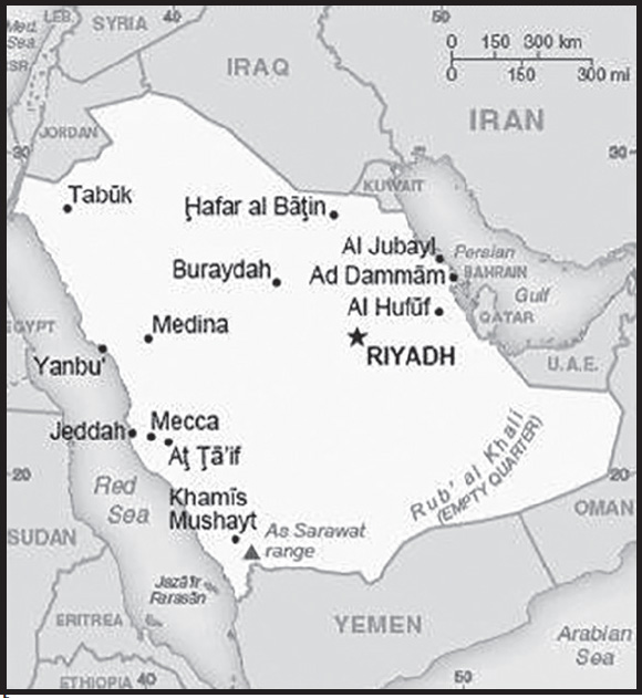
Location: Middle East, bordering the Persian Gulf and the Red Sea, north of Yemen
Geographic coordinates: 25 00 N, 45 00 E
Map references: Middle East
Area: total: 2,149,690 sq km
land: 2,149,690 sq km
water: 0 sq km
comparison ranking: total 14
Area - comparative: slightly more than one-fifth the size of the US
Land boundaries: total: 4,272 km
border countries (7): Iraq 811 km; Jordan 731 km; Kuwait 221 km; Oman 658 km; Qatar 87 km; UAE 457 km; Yemen 1,307 km
Coastline: 2,640 km
Maritime claims: territorial sea: 12 nm
contiguous zone: 18 nm
continental shelf: not specified
Climate: harsh, dry desert with great temperature extremes
Terrain: mostly sandy desert
Elevation: highest point: As Sarawat range, 3,000 m
lowest point: Persian Gulf 0 m
mean elevation: 665 m
Natural resources: petroleum, natural gas, iron ore, gold, copper
Land use: agricultural land: 80.7% (2018 est.)
arable land: 1.5% (2018 est.)
permanent crops: 0.1% (2018 est.)
permanent pasture: 79.1% (2018 est.)
forest: 0.5% (2018 est.)
other: 18.8% (2018 est.)
Irrigated land: 11,910 sq km (2018)
Major watersheds (area sq km): Indian Ocean drainage: (Persian Gulf) Tigris and Euphrates (918,044 sq km)
Major aquifers: Arabian Aquifer System
Population distribution: historically a population that was mostly nomadic or semi-nomadic, the Saudi population has become more settled since petroleum was discovered in the 1930s; most of the economic activities - and with it the country’s population - is concentrated in a wide area across the middle of the peninsula, from Ad Dammam in the east, through Riyadh in the interior, to Mecca-Medina in the west near the Red Sea
Natural hazards: frequent sand and dust storms
volcanism: despite many volcanic formations, there has been little activity in the past few centuries; volcanoes include Harrat Rahat, Harrat Khaybar, Harrat Lunayyir, and Jabal Yar
Geography - note: Saudi Arabia is the largest country in the world without a river; extensive coastlines on the Persian Gulf and Red Sea allow for considerable shipping (especially of crude oil) through the Persian Gulf and Suez Canal
PEOPLE AND SOCIETY
Population: 35,939,806 (2023 est.)
note: immigrants make up 38.3% of the total population, according to UN data (2019)
comparison ranking: 42
Nationality: noun: Saudi(s)
adjective: Saudi or Saudi Arabian
Ethnic groups: Arab 90%, Afro-Asian 10%
Languages: Arabic (official)
major-language sample(s):

(Arabic)
RELIGIONS
Muslim (official; citizens are 85-90% Sunni and 10-12% Shia), other (includes Eastern Orthodox, Protestant, Roman Catholic, Jewish, Hindu, Buddhist, and Sikh) (2020 est.)
note: despite having a large expatriate community of various faiths (more than 30% of the population), most forms of public religious expression inconsistent with the government-sanctioned interpretation of Sunni Islam are restricted; non-Muslims are not allowed to have Saudi citizenship and non-Muslim places of worship are not permitted (2013)
Age structure: 0-14 years: 23.45% (male 4,298,399/female 4,130,547)
15-64 years: 72.36% (male 15,251,742/female 10,752,649)
65 years and over: 4.19% (2023 est.) (male 799,270/female 707,199)
Dependency ratios: total dependency ratio: 40.4
youth dependency ratio: 36.8
elderly dependency ratio: 3.7
potential support ratio: 27.4 (2021 est.)
Median age: total: 32 years (2023 est.)
male: 34.2 years
female: 29 years
comparison ranking: total 115
Population growth rate: 1.65% (2023 est.)
comparison ranking: 58
Birth rate: 13.9 births/1,000 population (2023 est.)
comparison ranking: 125
Death rate: 3.5 deaths/1,000 population (2023 est.)
comparison ranking: 219
Net migration rate: 6.1 migrant(s)/1,000 population (2023 est.)
comparison ranking: 17
Population distribution: historically a population that was mostly nomadic or semi-nomadic, the Saudi population has become more settled since petroleum was discovered in the 1930s; most of the economic activities - and with it the country’s population - is concentrated in a wide area across the middle of the peninsula, from Ad Dammam in the east, through Riyadh in the interior, to Mecca-Medina in the west near the Red Sea
Urbanization: urban population: 85% of total population (2023)
rate of urbanization: 1.69% annual rate of change (2020-25 est.)
Major urban areas - population: 7.682 million RIYADH (capital), 4.863 million Jeddah, 2.150 million Mecca, 1.573 million Medina, 1.329 million Ad Dammam, 872,000 million Hufuf-Mubarraz (2023)
Sex ratio: at birth: 1.05 male(s)/female
0-14 years: 1.04 male(s)/female
15-64 years: 1.42 male(s)/female
65 years and over: 1.13 male(s)/female
total population: 1.31 male(s)/female (2023 est.)
Maternal mortality ratio: 16 deaths/100,000 live births (2020 est.)
comparison ranking: 134
Infant mortality rate: total: 12 deaths/1,000 live births (2023 est.)
male: 13.2 deaths/1,000 live births
female: 10.7 deaths/1,000 live births
comparison ranking: total 112
Life expectancy at birth: total population: 76.9 years (2023 est.)
male: 75.3 years
female: 78.6 years
comparison ranking: total population 96
Total fertility rate: 1.89 children born/woman (2023 est.)
comparison ranking: 127
Gross reproduction rate: 0.92 (2023 est.)
Contraceptive prevalence rate: 27.9% (2019)
Drinking water source: improved:
total: 100% of population
unimproved: total: 0% of population (2020 est.)
Current health expenditure: 5.5% of GDP (2018)
Physicians density: 2.74 physicians/1,000 population (2020)
Hospital bed density: 2.2 beds/1,000 population (2017)
Sanitation facility access: improved:
total: 100% of population
unimproved: total: 0% of population (2020 est.)
Obesity - adult prevalence rate: 35.4% (2016)
comparison ranking: 14
Alcohol consumption per capita: total: 0 liters of pure alcohol (2019 est.)
beer: 0 liters of pure alcohol (2019 est.)
wine: 0 liters of pure alcohol (2019 est.)
spirits: 0 liters of pure alcohol (2019 est.)
other alcohols: 0 liters of pure alcohol (2019 est.)
comparison ranking: total 185
Tobacco use: total: 14.3% (2020 est.)
male: 26.5% (2020 est.)
female: 2% (2020 est.)
comparison ranking: total 110
Children under the age of 5 years underweight: 3.5% (2020)
comparison ranking: 83
Currently married women (ages 15-49): 63.2% (2023 est.)
Education expenditures: 7.8% of GDP (2020)
comparison ranking: 12
Literacy: definition: age 15 and over can read and write
total population: 97.6%
male: 98.6%
female: 96% (2020)
School life expectancy (primary to tertiary education): total: 17 years
male: 17 years
female: 16 years (2021)
Youth unemployment rate (ages 15-24): total: 28.8% (2021 est.)
male: 22.4%
female: 47.9%
comparison ranking: total 44
ENVIRONMENT
Environment - current issues: desertification; depletion of underground water resources; the lack of perennial rivers or permanent water bodies has prompted the development of extensive seawater desalination facilities; coastal pollution from oil spills; air pollution; waste management
Environment - international agreements: party to: Biodiversity, Climate Change, Climate Change-Kyoto Protocol, Climate Change-Paris Agreement, Desertification, Endangered Species, Hazardous Wastes, Law of the Sea, Marine Dumping-London Protocol, Ozone Layer Protection, Ship Pollution
signed, but not ratified: none of the selected agreements
Climate: harsh, dry desert with great temperature extremes
Land use: agricultural land: 80.7% (2018 est.)
arable land: 1.5% (2018 est.)
permanent crops: 0.1% (2018 est.)
permanent pasture: 79.1% (2018 est.)
forest: 0.5% (2018 est.)
other: 18.8% (2018 est.)
Urbanization: urban population: 85% of total population (2023)
rate of urbanization: 1.69% annual rate of change (2020-25 est.)
Revenue from forest resources: 0% of GDP (2018 est.)
comparison ranking: 178
Revenue from coal: 0% of GDP (2018 est.)
comparison ranking: 84
Air pollutants: particulate matter emissions: 57.16 micrograms per cubic meter (2019 est.)
carbon dioxide emissions: 563.45 megatons (2016 est.)
methane emissions: 45.47 megatons (2020 est.)
Waste and recycling: municipal solid waste generated annually: 16,125,701 tons (2015 est.)
municipal solid waste recycled annually: 2,418,855 tons (2015 est.)
percent of municipal solid waste recycled: 15% (2015 est.)
Major watersheds (area sq km): Indian Ocean drainage: (Persian Gulf) Tigris and Euphrates (918,044 sq km)
Major aquifers: Arabian Aquifer System
Total water withdrawal: municipal: 3.39 billion cubic meters (2020 est.)
industrial: 1.4 billion cubic meters (2020 est.)
agricultural: 21.2 billion cubic meters (2020 est.)
Total renewable water resources: 2.4 billion cubic meters (2020 est.)
GOVERNMENT
Country name: conventional long form: Kingdom of Saudi Arabia
conventional short form: Saudi Arabia
local long form: Al Mamlakah al Arabiyah as Suudiyah
local short form: Al Arabiyah as Suudiyah
etymology: named after the ruling dynasty of the country, the House of Saud; the name “Arabia” can be traced back many centuries B.C., the ancient Egyptians referred to the region as “Ar Rabi”
Government type: absolute monarchy
Capital: name: Riyadh
geographic coordinates: 24 39 N, 46 42 E
time difference: UTC+3 (8 hours ahead of Washington, DC, during Standard Time)
etymology: the name derives from the Arabic word “riyadh,” meaning “gardens,” and refers to various oasis towns in the area that merged to form the city
Administrative divisions: 13 regions (manatiq, singular - mintaqah); Al Bahah, Al Hudud ash Shamaliyah (Northern Border), Al Jawf, Al Madinah al Munawwarah (Medina), Al Qasim, Ar Riyad (Riyadh), Ash Sharqiyah (Eastern), ‘Asir, Ha’il, Jazan, Makkah al Mukarramah (Mecca), Najran, Tabuk
Independence: 23 September 1932 (unification of the kingdom)
National holiday: Saudi National Day (Unification of the Kingdom), 23 September (1932)
Constitution: history: 1 March 1992 - Basic Law of Government, issued by royal decree, serves as the constitutional framework and is based on the Qur’an and the life and traditions of the Prophet Muhammad
amendments: proposed by the king directly or proposed to the king by the Consultative Assembly or by the Council of Ministers; passage by the king through royal decree; Basic Law amended many times, last in 2017
Legal system: Islamic (sharia) legal system with some elements of Egyptian, French, and customary law; note - several secular codes have been introduced; commercial disputes handled by special committees
International law organization participation: has not submitted an ICJ jurisdiction declaration; non-party state to the ICCt
Citizenship: citizenship by birth: no
citizenship by descent only: the father must be a citizen of Saudi Arabia; a child born out of wedlock in Saudi Arabia to a Saudi mother and unknown father
dual citizenship recognized: no
residency requirement for naturalization: 5 years
Suffrage: 18 years of age; universal for municipal elections
https://www.wilsoncenter.org/publication/saudi-women-go-to-the-polls-finally
Executive branch: chief of state: King SALMAN bin Abd al-Aziz Al Saud (since 23 January 2015); Crown Prince MUHAMMAD BIN SALMAN bin Abd al-Aziz Al Saud (born 31 August 1985)
head of government: Crown Prince and Prime Minister MUHAMMAD BIN SALMAN bin Abd al-Aziz Al Saud (since 27 September 2022)
cabinet: Council of Ministers appointed by the monarch every 4 years and includes many royal family members
elections/appointments: none; the monarchy is hereditary; an Allegiance Council created by royal decree in October 2006 established a committee of Saudi princes for a voice in selecting future Saudi kings
Legislative branch: description: unicameral Consultative Council or Majlis al-Shura (150 seats plus a speaker; members appointed by the monarch to serve 4-year terms); note - in early 2013, the monarch granted women 30 seats on the Council
note: composition as of 2021 - men 121, women 30, percent of women 19.9%
Judicial branch: highest court(s): High Court (consists of the court chief and organized into circuits with 3-judge panels, except for the criminal circuit, which has a 5-judge panel for cases involving major punishments)
judge selection and term of office: High Court chief and chiefs of the High Court Circuits appointed by royal decree upon the recommendation of the Supreme Judiciary Council, a 10-member body of high-level judges and other judicial heads; new judges and assistant judges serve 1- and 2-year probations, respectively, before permanent assignment
subordinate courts: Court of Appeals; Specialized Criminal Court, first-degree courts composed of general, criminal, personal status, and commercial courts; Labor Court; a hierarchy of administrative courts
Political parties and leaders: none
International organization participation: ABEDA, AfDB (nonregional member), AFESD, AMF, BIS, CAEU, CP, FAO, G-20, G-77, GCC, IAEA, IBRD, ICAO, ICC (national committees), ICRM, IDA, IDB, IFAD, IFC, IFRCS, IHO, ILO, IMF, IMO, IMSO, Interpol, IOC, IOM (observer), IPU, ISO, ITSO, ITU, LAS, MIGA, NAM, OAPEC, OAS (observer), OIC, OPCW, OPEC, PCA, UN, UNCTAD, UNESCO, UNIDO, UNOOSA, UNRWA, UNWTO, UPU, WCO, WFTU (NGOs), WHO, WIPO, WMO, WTO
Diplomatic representation in the US: chief of mission: Ambassador Reema Bint Bandar Bin Sultan AL SAUD (since 8 July 2019)
chancery: 601 New Hampshire Avenue NW, Washington, DC 20037
telephone: [1] (202) 342-3800
FAX: [1] (202) 295-3625
email address and website:
info@saudiembassy.net; Saudisusemb@mofa.gov.sa
consulate(s) general: Houston, Los Angeles, New York
Diplomatic representation from the US: chief of mission: Ambassador Michael RATNEY (since 27 April 2023)
embassy: Riyadh 11564
mailing address: 6300 Riyadh Place, Washington DC 20521-6300
telephone: [966] (11) 835-4000
FAX: [966] (11) 488-7360
email address and website:
consulate(s) general: Dhahran, Jeddah
Flag description: green, a traditional color in Islamic flags, with the Shahada or Muslim creed in large white Arabic script (translated as “There is no god but God; Muhammad is the Messenger of God”) above a white horizontal saber (the tip points to the hoist side); design dates to the early twentieth century and is closely associated with the Al Saud family, which established the kingdom in 1932; the flag is manufactured with differing obverse and reverse sides so that the Shahada reads - and the sword points - correctly from right to left on both sides
note: the only national flag to display an inscription as its principal design; one of only three national flags that differ on their obverse and reverse sides - the others are Moldova and Paraguay
National symbol(s): palm tree surmounting two crossed swords; national colors: green, white
National anthem: name: “Aash Al Maleek” (Long Live Our Beloved King)
lyrics/music: Ibrahim KHAFAJI/Abdul Rahman al-KHATEEB
note: music adopted 1947, lyrics adopted 1984
National heritage: total World Heritage Sites: 6 (all cultural)
selected World Heritage Site locales: Hegra Archaeological Site (al-Hijr /  ); At-Turaif District in ad-Dir’iyah; Historic Jeddah, the Gate to Makkah; Rock Art in the Hail Region; Al-Ahsa Oasis;
 Cultural Area
ECONOMY
Economic overview: high-income, oil-based Middle Eastern economy; OPEC leader; diversifying portfolio; declining per-capita incomes; young labor force; key human capital gaps; heavy bureaucracy and increasing corruption; substantial poverty; low innovation economy
Real GDP (purchasing power parity): $1.594 trillion (2021 est.)
$1.544 trillion (2020 est.)
$1.611 trillion (2019 est.)
note: data are in 2017 dollars
comparison ranking: 17
Real GDP growth rate: 3.24% (2021 est.)
-4.14% (2020 est.)
0.33% (2019 est.)
comparison ranking: 140
Real GDP per capita: $44,300 (2021 est.)
$42,900 (2020 est.)
$45,000 (2019 est.)
note: data are in 2017 dollars
comparison ranking: 39
GDP (official exchange rate): $792.849 billion (2019 est.)
Inflation rate (consumer prices): 3.06% (2021 est.)
3.45% (2020 est.)
-2.09% (2019 est.)
comparison ranking: 122
Credit ratings: Fitch rating: A (2019)
Moody’s rating: A1 (2016)
Standard & Poors rating: A- (2016)
note: The year refers to the year in which the current credit rating was first obtained.
GDP - composition, by sector of origin: agriculture: 2.6% (2017 est.)
industry: 44.2% (2017 est.)
services: 53.2% (2017 est.)
comparison rankings: services 166; industry 20; agriculture 159
GDP - composition, by end use: household consumption: 41.3% (2017 est.)
government consumption: 24.5% (2017 est.)
investment in fixed capital: 23.2% (2017 est.)
investment in inventories: 4.7% (2017 est.)
exports of goods and services: 34.8% (2017 est.)
imports of goods and services: -28.6% (2017 est.)
Agricultural products: milk, dates, poultry, fruit, watermelons, barley, wheat, potatoes, eggs, tomatoes
Industries: crude oil production, petroleum refining, basic petrochemicals, ammonia, industrial gases, sodium hydroxide (caustic soda), cement, fertilizer, plastics, metals, commercial ship repair, commercial aircraft repair, construction
Industrial production growth rate: 1.71% (2021 est.)
comparison ranking: 139
Labor force: 16.06 million (2021 est.)
note: comprised of 3.1 million Saudis and 10.7 million non-Saudis
comparison ranking: 40
Labor force - by occupation: agriculture: 6.7%
industry: 21.4%
services: 71.9% (2005 est.)
Unemployment rate: 7.36% (2021 est.)
7.45% (2020 est.)
5.67% (2019 est.)
note: data are for total population; unemployment among Saudi nationals is more than double
comparison ranking: 108
Youth unemployment rate (ages 15-24): total: 28.8% (2021 est.)
male: 22.4%
female: 47.9%
comparison ranking: total 44
Gini Index coefficient - distribution of family income: 45.9 (2013 est.)
comparison ranking: 24
Average household expenditures: on food: 20.6% of household expenditures (2018 est.)
on alcohol and tobacco: 0.6% of household expenditures (2018 est.)
Budget: revenues: $247.093 billion (2019 est.)
expenditures: $282.4 billion (2019 est.)
Budget surplus (+) or deficit (-): -8.9% (of GDP) (2017 est.)
comparison ranking: 204
Public debt: 17.2% of GDP (2017 est.)
13.1% of GDP (2016 est.)
comparison ranking: 195
Taxes and other revenues: 8.6% (of GDP) (2020 est.)
comparison ranking: 204
Fiscal year: calendar year
Current account balance: $44.324 billion (2021 est.)
-$22.814 billion (2020 est.)
$38.23 billion (2019 est.)
comparison ranking: 14
Exports: $286.502 billion (2021 est.) note: data are in current year dollars
$182.848 billion (2020 est.) note: data are in current year dollars
$285.86 billion (2019 est.) note: data are in current year dollars
comparison ranking: 28
Exports - partners: China 19%, India 10%, Japan 9%, South Korea 8%, United Arab Emirates 5% (2021)
Exports - commodities: crude petroleum, refined petroleum, polymers, industrial alcohols, natural gas (2021)
Imports: $213.016 billion (2021 est.) note: data are in current year dollars
$182.184 billion (2020 est.) note: data are in current year dollars
$218.941 billion (2019 est.) note: data are in current year dollars
comparison ranking: 32
Imports - partners: China 19%, United Arab Emirates 15%, United States 8%, India 6%, Germany 4% (2021)
Imports - commodities: cars, refined petroleum, broadcasting equipment, gold, packaged medicines (2021)
Reserves of foreign exchange and gold: $473.89 billion (31 December 2021 est.)
$472.851 billion (31 December 2020 est.)
$514.963 billion (31 December 2019 est.)
comparison ranking: 8
Debt - external: $205.1 billion (31 December 2017 est.)
$189.3 billion (31 December 2016 est.)
comparison ranking: 38
Exchange rates: Saudi riyals (SAR) per US dollar -
Exchange rates:
3.75 (2021 est.)
3.75 (2020 est.)
3.75 (2019 est.)
3.75 (2018 est.)
3.75 (2017 est.)
ENERGY
Electricity access: electrification - total population: 100% (2021)
Electricity: installed generating capacity: 76.785 million kW (2020 est.)
consumption: 331,381,500,000 kWh (2019 est.)
exports: 0 kWh (2020 est.)
imports: 0 kWh (2020 est.)
transmission/distribution losses: 31.055 billion kWh (2019 est.)
comparison rankings: imports 193; exports 190; installed generating capacity 18; transmission/distribution losses 13; consumption 11
Electricity generation sources: fossil fuels: 99.9% of total installed capacity (2020 est.)
solar: 0.2% of total installed capacity (2020 est.)
Coal: production: 0 metric tons (2020 est.)
consumption: 73,000 metric tons (2020 est.)
exports: 0 metric tons (2020 est.)
imports: 73,000 metric tons (2020 est.)
proven reserves: 0 metric tons (2019 est.)
Petroleum: total petroleum production: 10,815,700 bbl/day (2021 est.)
refined petroleum consumption: 3,182,300 bbl/day (2019 est.)
crude oil and lease condensate exports: 7,340,800 bbl/day (2018 est.)
crude oil and lease condensate imports: 0 bbl/day (2018 est.)
crude oil estimated reserves: 258.6 billion barrels (2021 est.)
Refined petroleum products - production: 2.476 million bbl/day (2015 est.)
comparison ranking: 8
Refined petroleum products - exports: 1.784 million bbl/day (2015 est.)
comparison ranking: 5
Refined petroleum products - imports: 609,600 bbl/day (2015 est.)
comparison ranking: 13
Natural gas: production: 113,776,648,000 cubic meters (2020 est.)
consumption: 113,776,648,000 cubic meters (2020 est.)
exports: 0 cubic meters (2021 est.)
imports: 0 cubic meters (2021 est.)
proven reserves: 9,422,812,000,000 cubic meters (2021 est.)
Carbon dioxide emissions: 579.925 million metric tonnes of CO2 (2019 est.)
from coal and metallurgical coke: 300,000 metric tonnes of CO2 (2019 est.)
from petroleum and other liquids: 358.414 million metric tonnes of CO2 (2019 est.)
from consumed natural gas: 221.211 million metric tonnes of CO2 (2019 est.)
comparison ranking: total emissions 10
Energy consumption per capita: 296.949 million Btu/person (2019 est.)
comparison ranking: 12
COMMUNICATIONS
Telephones - fixed lines: total subscriptions: 6,594,631 (2021 est.)
subscriptions per 100 inhabitants: 18 (2021 est.)
comparison ranking: total subscriptions 23
Telephones - mobile cellular: total subscriptions: 45,427,321 (2021 est.)
subscriptions per 100 inhabitants: 126 (2021 est.)
comparison ranking: total subscriptions 37
Telecommunication systems: general assessment: Saudi Arabia’s telecom and ICT sectors continue to benefit from the range of programs aimed at diversifying the economy away from a dependence on oil, and establishing a wider digital transformation over the next decade; an essential element of this has been the widening reach of 5G networks, which by mid-2021 reached about half of the population and the majority of cities; the MNOs have focused investment on upgrading LTE infrastructure and further developing 5G; this in part is aimed at generating additional revenue from mobile data services, and also to their contribution to the Vision 2030 program; the ongoing pandemic has resulted in more people working and schooling from home during periods of restricted travel; this has stimulated growth in mobile data traffic, while the government has encouraged non-cash transactions and so helped develop the vast e-commerce market; while Saudi Arabia’s fixed broadband penetration remains relatively low, there has been a concentration of fiber infrastructure and the Kingdom has developed one of the fastest services in the region (2022)
domestic: fixed-line are 18 per 100 and mobile-cellular subscribership is 126 per 100 persons (2021)
international: country code - 966; landing points for the SeaMeWe-3, -4, -5, AAE-1, EIG, FALCON, FEA, IMEWE, MENA/Gulf Bridge International, SEACOM, SAS-1, -2, GBICS/MENA, and the Tata TGN-Gulf submarine cables providing connectivity to Europe, Africa, the Middle East, Asia, Southeast Asia and Australia; microwave radio relay to Bahrain, Jordan, Kuwait, Qatar, UAE, Yemen, and Sudan; coaxial cable to Kuwait and Jordan; satellite earth stations - 5 Intelsat (3 Atlantic Ocean and 2 Indian Ocean), 1 Arabsat, and 1 Inmarsat (Indian Ocean region) (2019)
Broadcast media: broadcast media are state-controlled; state-run TV operates 4 networks; Saudi Arabia is a major market for pan-Arab satellite TV broadcasters; state-run radio operates several networks; multiple international broadcasters are available
Internet country code: .sa
Internet users: total: 36 million (2021 est.)
percent of population: 100% (2021 est.)
comparison ranking: total 27
Broadband - fixed subscriptions: total: 7,890,261 (2020 est.)
subscriptions per 100 inhabitants: 23 (2020 est.)
comparison ranking: total 26
Communications - note: the innovative King Abdulaziz Center for World Culture (informally known as Ithra, meaning “enrichment”) opened on 1 December 2017 in Dhahran, Eastern Region; its facilities include a grand library, several museums, an archive, an Idea Lab, a theater, a cinema, and an Energy Exhibit, all which are meant to provide visitors an immersive and transformative experience
TRANSPORTATION
National air transport system: number of registered air carriers: 12 (2020)
inventory of registered aircraft operated by air carriers: 230
annual passenger traffic on registered air carriers: 39,141,660 (2018)
annual freight traffic on registered air carriers: 1,085,470,000 (2018) mt-km
Civil aircraft registration country code prefix: HZ
Airports: 214 (2021)
comparison ranking: total 27
Airports - with paved runways: 82
civil airports: 17
military airports: 10
joint use (civil-military) airports: 6
other airports: 49
note: paved runways have a concrete or asphalt surface but not all have facilities for refueling, maintenance, or air traffic control; the length of a runway required for aircraft to safely operate depends on a number of factors including the type of aircraft, the takeoff weight (including passengers, cargo, and fuel), engine types, flap settings, landing speed, elevation of the airport, and average maximum daily air temperature; paved runways can reach a length of 5,000 m (16,000 ft.), but the “typical” length of a commercial airline runway is between 2,500-4,000 m (8,000-13,000 ft.)
Airports - with unpaved runways: 132
note: unpaved runways have a surface composition such as grass or packed earth and are most suited to the operation of light aircraft; unpaved runways are usually short, often less than 1,000 m (3,280 ft.) in length; airports with unpaved runways often lack facilities for refueling, maintenance, or air traffic control
Heliports: 10 (2021)
Pipelines: 209 km condensate, 2,940 km gas, 1,183 km liquid petroleum gas, 5,117 km oil, 1,151 km refined products (2013)
Railways: total: 5,410 km (2016)
standard gauge: 5,410 km (2016) 1.435-m gauge (with branch lines and sidings)
comparison ranking: total 35
Roadways: total: 221,372 km (2006)
paved: 47,529 km (2006) (includes 3,891 km of expressways)
unpaved: 173,843 km (2006)
comparison ranking: total 24
Merchant marine: total: 413 (2022)
by type: bulk carrier 6, container ship 1, general cargo 21, oil tanker 58, other 327
comparison ranking: total 46
Ports and terminals: major seaport(s): Ad Dammam, Al Jubayl, Jeddah, King Abdulla, Yanbu’
container port(s) (TEUs): Ad Dammam (1,770,000), Jeddah (4,882,342), King Abdulla (2,813,920) (2021)
MILITARY AND SECURITY
Military and security forces: the Saudi Arabian Armed Forces (SAAF) include forces from two ministries:
Ministry of Defense: Royal Saudi Land Forces, Royal Saudi Naval Forces (includes marines, special forces, naval aviation), Royal Saudi Air Force, Royal Saudi Air Defense Forces, Royal Saudi Strategic Missiles Force; Ministry of the National Guard: Saudi Arabian National Guard (SANG)
Ministry of Interior: police, Border Guard, Facilities Security Force
State Security Presidency (SSP): General Directorate of Investigation (Mabahith), Special Security Forces, Special Emergency Forces (2023)
note 1: the SANG (also known as the White Army) is a land force comprised off tribal elements loyal to the House of Saud; it is responsible for internal security, protecting the royal family, and external defense
note 2: the SAAF includes the Saudi Royal Guard Command, a unit which provides security and protection to the ruling family and other dignitaries
Military expenditures: 6% of GDP (2022 est.)
6% of GDP (2021 est.)
8% of GDP (2020 est.)
8.8% of GDP (2019 est.)
10% of GDP (2018 est.)
comparison ranking: 3
Military and security service personnel strengths: the Saudi Armed Forces have about 250,000 total active troops; approximately 125,000 under the Ministry of Defense (75,000 Land Forces; 15,000 Naval Forces, including about 3,000 marines; 35,000 Air Force/Air Defense/Strategic Missile Forces) and up to 125,000 in the Saudi Arabia National Guard (SANG) (2023)
note: SANG also has an irregular force (Fowj), primarily Bedouin tribal volunteers, with a total strength of approximately 25,000
Military equipment inventories and acquisitions: the inventory of the Saudi military forces, including the SANG, includes a mix of mostly modern weapons systems from the US and Europe; in recent years, the US has been the leading supplier of armaments; other major suppliers include France and the UK; Saudi Arabia is one of the world’s largest importers of arms (2023)
note: the Saudi Navy is in the midst of a multi-year and multi-billion-dollar expansion and modernization program to purchase new frigates, corvettes, and other naval craft from such suppliers as Spain and the US
Military service age and obligation: men (17-40) and women (21-40) may volunteer for military service; no conscription (2023)
note 1: in 2021, women were allowed to serve in the Army, Air Defense, Navy, Strategic Missile Force, medical services, and internal security forces up to the rank of non-commissioned officer
note 2: the National Guard is restricted to citizens, but the regular Saudi military has hired foreigners on contract for operations associated with its intervention in Yemen
Military deployments: continues to maintain a military presence in Yemen; has also established and supports several local militias, including the National Shield Forces in Aden and the Amajid Brigade in Abyan (2023)
Military - note: the Saudi Arabian Armed Forces (SAAF) are divided into the regular forces under the Ministry of Defense and the Saudi Arabian National Guard (SANG); the regular forces are responsible for territorial defense, although they can be called for domestic security duties if needed; they include land, naval, air, air defense, and strategic missile forces; the Land Forces have approximately 15 combat brigades which include a mix of armored, aviation, light infantry, mechanized or motorized infantry, royal guards, and airborne/special forces, plus separate battalions of artillery; the Naval Forces are undergoing a major acquisitions and modernization program; its principal warships are approximately 16 frigates and corvettes, with an additional 4 frigates on order; the Air Force is the largest and one of the most modern in the region, with over 350 combat aircraft from Europe and the US with more on order; the Strategic Missile Force manages Saudi Arabia’s ballistic missile inventory, largely acquired from China
the SANG is responsible for both internal security and external defense; its duties include protecting the royal family, guarding against military coups, defending strategic facilities and resources, and providing security for the cities of Mecca and Medina; the SANG is primarily comprised of tribal elements loyal to the Saud family and has at least 11 brigades of light infantry, mechanized/motorized infantry, and security forces; it is supplemented by combat helicopter units and tribal levies/militias known as Fowj
there are also large numbers of paramilitary forces under the Ministry of Interior, including Border Guards and the Facilities Security Force, as well as the Special Security Forces and Special Emergency Forces under the State Security Presidency
the US is Saudi Arabia’s closest security partner; the SAAF conducts bilateral exercises with the US military and hosts US forces; the US has participated in a cooperative program to equip and train the SANG since 1973; much of the equipment for both the regular forces and the SANG has been acquired from the US; Saudi Arabia also has defense relationships with China, France, India, the UK, and fellow Gulf Cooperation Council members
in 2015, Saudi Arabia led a military intervention into Yemen by a coalition of Arab states in support of the Republic of Yemen Government against the separatist Huthis; Saudi forces from both the Ministry of Defense and the SANG participated in combat operations in Yemen; Saudi Arabia also raised and equipped paramilitary/militia security forces in Yemen--based largely on tribal or regional affiliation--to deploy along the Saudi-Yemen border (2023)
SPACE
Space agency/agencies: Saudi Space Commission (SSC; established 2018); King Abdulaziz City for Science and Technology (KACST; established 1977); KACST includes the Space and Aeronautics Research Institute (SARI; established 2000) (2023)
Space program overview: has one of the more advanced space programs in the region; manufactures and operates communications, remote sensing (RS), and scientific satellites; develops a range of satellite subsystems and payload technologies; SSC’s missions also include accelerating economic diversification, enhancing research and development, and raising private sector participation in the global space industry; is the main founder and financier of the Arab Satellite Communications Organization (Arabsat; launched in 1976; headquartered in Riyadh, Saudi Arabia and the primary satellite communications service provider for over 170 million persons in the Arab world); cooperates with the space agencies and industries of a wide range of countries, including those of Belarus, China, the European Space Agency and its member states (particularly France, Germany, Greece, and Hungary), India, Kazakhstan, Morocco, Russia, South Africa, South Korea, Ukraine, the UAE, the UK, and the US; member of the Arab Space Cooperation Group (established by the UAE in 2019 and includes Algeria, Bahrain, Egypt, Jordan, Kuwait, Lebanon, Morocco, and Sudan) (2023)
note: further details about the key activities, programs, and milestones of the country’s space program, as well as government spending estimates on the space sector, appear in Appendix S
TERRORISM
Terrorist group(s): Islamic State of Iraq and ash-Sham (ISIS); al-Qa’ida; al-Qa’ida in the Arabian Peninsula (AQAP)
note: details about the history, aims, leadership, organization, areas of operation, tactics, targets, weapons, size, and sources of support of the group(s) appear(s) in Appendix-T
TRANSNATIONAL ISSUES
Disputes - international: Saudi Arabia-Bahrain: none identified
Saudi Arabia-Iraq: Saudi Arabia has been building a fence along its border with Iraq to keep out militants and smugglers
Saudi Arabia-Jordan: Jordan and Saudi Arabia signed an agreement to demarcate their maritime borders in 2007
Saudi Arabia-Kuwait: Kuwait and Saudi Arabia continue discussions on a maritime boundary with Iran; in December 2019, Saudi Arabia and Kuwait signed an agreement to demarcate land in a neutral zone and to restart oil production in shared fields, which had been suspended since 2014 because of disagreements
Saudi Arabia-Oman: none identified
Saudi Arabia-Qatar: none identified
Saudi Arabia-UAE: Saudi Arabia and UAE have disputed the Shaybah oilfield, which Saudi Arabia controls
Saudi Arabia-Yemen: the two countries signed the Treaty of Jeddah in 2000, which specified the coordinates of their land and maritime border and made provisions for grazing, the placement of armed forces, and future resource exploitation; in 2010, Saudi Arabia reinforced its concrete-filled security barrier along sections of the now fully demarcated border with Yemen to stem illegal crossborder activities
Refugees and internally displaced persons: stateless persons: 70,000 (2022); note - thousands of biduns (stateless Arabs) are descendants of nomadic tribes who were not officially registered when national borders were established, while others migrated to Saudi Arabia in search of jobs; some have temporary identification cards that must be renewed every five years, but their rights remain restricted; most Palestinians have only legal resident status; some naturalized Yemenis were made stateless after being stripped of their passports when Yemen backed Iraq in its invasion of Kuwait in 1990; Saudi women cannot pass their citizenship on to their children, so if they marry a non-national, their children risk statelessness
Illicit drugs: regularly sentences drug traffickers to the death penalty, although a moratorium on executions for drug offences has been in place since at least 2020; improving anti-money-laundering legislation and enforcement
SENEGAL
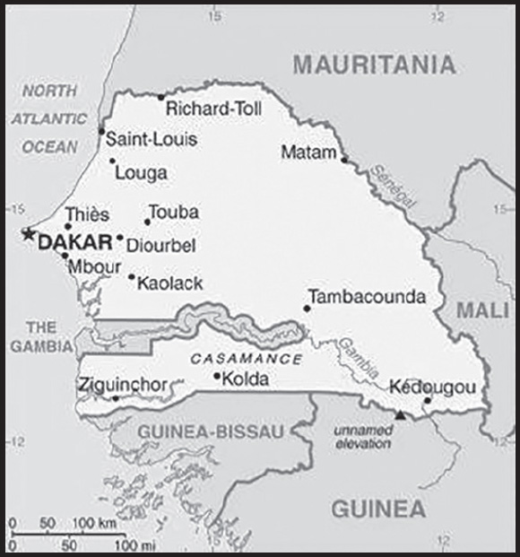
INTRODUCTION
Background: Senegal is one of the few countries in the world with evidence of continuous human life from the Paleolithic period to present. Between the 14th and 16th centuries, the Jolof Empire ruled most of Senegal. Starting in the 15th century, Portugal, the Netherlands, France, and Great Britain traded along the Senegalese coast. Senegal’s location on the western tip of Africa made it a favorable base for the European slave trade. European powers used the Senegalese island of Goree as a base to purchase slaves from the warring chiefdoms on the mainland, and at the height of the slave trade in Senegal, over one-third of the Senegalese population was enslaved. In 1815, France abolished slavery and began expanding inland. During the second half of the 19th century, France took possession of Senegal as a French colony. In 1959, the French colonies of Senegal and French Sudan were merged and granted independence in 1960 as the Mali Federation. The union broke up after only a few months. In 1982, Senegal joined with The Gambia to form the nominal confederation of Senegambia. The envisaged integration of the two countries was never implemented, and the union dissolved in 1989.
Since the 1980s, the Movement of Democratic Forces in the Casamance - a separatist movement based in southern Senegal - has led a low-level insurgency. Several attempts at reaching a comprehensive peace agreement have failed. Since 2012, despite sporadic incidents of violence, an unofficial cease-fire has remained largely in effect. Senegal is one of the most stable democracies in Africa and has a long history of participating in international peacekeeping and regional mediation. The Socialist Party of Senegal ruled for 40 years until Abdoulaye WADE was elected president in 2000 and re-elected in 2007. WADE amended Senegal’s constitution over a dozen times to increase executive power and weaken the opposition. In 2012, WADE’s decision to run for a third presidential term sparked public backlash that led to his defeat to current President Macky SALL. A 2016 constitutional referendum limited future presidents to two consecutive five-year terms. The change, however, does not apply to SALL’s first term. In February 2019, SALL won his bid for reelection; his second term will end in 2024.
GEOGRAPHY
Location: Western Africa, bordering the North Atlantic Ocean, between Guinea-Bissau and Mauritania
Geographic coordinates: 14 00 N, 14 00 W
Map references: Africa
Area: total: 196,722 sq km
land: 192,530 sq km
water: 4,192 sq km
comparison ranking: total 88
Area - comparative: slightly smaller than South Dakota; slightly larger than twice the size of Indiana
Land boundaries: total: 2,684 km
border countries (5): The Gambia 749 km; Guinea 363 km; Guinea-Bissau 341 km; Mali 489 km; Mauritania 742 km
Coastline: 531 km
Maritime claims: territorial sea: 12 nm
contiguous zone: 24 nm
exclusive economic zone: 200 nm
continental shelf: 200 nm or to the edge of the continental margin
Climate: tropical; hot, humid; rainy season (May to November) has strong southeast winds; dry season (December to April) dominated by hot, dry, harmattan wind
Terrain: generally low, rolling, plains rising to foothills in southeast
Elevation: highest point: unnamed elevation 2.8 km southeast of Nepen Diaka 648 m
lowest point: Atlantic Ocean 0 m
mean elevation: 69 m
Natural resources: fish, phosphates, iron ore
Land use: agricultural land: 46.8% (2018 est.)
arable land: 17.4% (2018 est.)
permanent crops: 0.3% (2018 est.)
permanent pasture: 29.1% (2018 est.)
forest: 43.8% (2018 est.)
other: 9.4% (2018 est.)
Irrigated land: 1,200 sq km (2012)
Major rivers (by length in km): Senegal (shared with Guinea [s], Mali, and Mauritania [m]) - 1,641 km; Gambie (Gambia) (shared with Guinea [s] and The Gambia [m]) - 1,094 km
note – [s] after country name indicates river source; [m] after country name indicates river mouth
Major watersheds (area sq km): Atlantic Ocean drainage: Senegal (456,397 sq km)
Major aquifers: Senegalo-Mauritanian Basin
Population distribution: the population is concentrated in the west, with Dakar anchoring a well-defined core area; approximately 70% of the population is rural as shown in this population distribution map
Natural hazards: lowlands seasonally flooded; periodic droughts
Geography - note: westernmost country on the African continent; The Gambia is almost an enclave within Senegal
PEOPLE AND SOCIETY
Population: 18,384,660 (2023 est.)
comparison ranking: 67
Nationality: noun: Senegalese (singular and plural)
adjective: Senegalese
Ethnic groups: Wolof 39.7%, Pular 27.5%, Serer 16%, Mandinka 4.9%, Jola 4.2%, Soninke 2.4%, other 5.4% (includes Europeans and persons of Lebanese descent) (2019 est.)
Languages: French (official), Wolof, Pular, Jola, Mandinka, Serer, Soninke
Religions: Muslim 97.2% (most adhere to one of the four main Sufi brotherhoods), Christian 2.7% (mostly Roman Catholic) (2019 est.)
Demographic profile: Senegal has a large and growing youth population but has not been successful in developing its potential human capital. Senegal’s high total fertility rate of almost 4.5 children per woman continues to bolster the country’s large youth cohort – more than 60% of the population is under the age of 25. Fertility remains high because of the continued desire for large families, the low use of family planning, and early childbearing. Because of the country’s high illiteracy rate (more than 40%), high unemployment (even among university graduates), and widespread poverty, Senegalese youths face dim prospects; women are especially disadvantaged.
Senegal historically was a destination country for economic migrants, but in recent years West African migrants more often use Senegal as a transit point to North Africa – and sometimes illegally onward to Europe. The country also has been host to several thousand black Mauritanian refugees since they were expelled from their homeland during its 1989 border conflict with Senegal. The country’s economic crisis in the 1970s stimulated emigration; departures accelerated in the 1990s. Destinations shifted from neighboring countries, which were experiencing economic decline, civil wars, and increasing xenophobia, to Libya and Mauritania because of their booming oil industries and to developed countries (most notably former colonial ruler France, as well as Italy and Spain). The latter became attractive in the 1990s because of job opportunities and their periodic regularization programs (legalizing the status of illegal migrants).
Age structure: 0-14 years: 41.19% (male 3,858,937/female 3,714,062)
15-64 years: 55.46% (male 4,925,324/female 5,271,627)
65 years and over: 3.34% (2023 est.) (male 266,485/female 348,225)
Dependency ratios: total dependency ratio: 81.5
youth dependency ratio: 75.8
elderly dependency ratio: 5.7
potential support ratio: 17.4 (2021 est.)
Median age: total: 19 years (2023 est.)
male: 18.2 years
female: 19.8 years
comparison ranking: total 212
Population growth rate: 2.52% (2023 est.)
comparison ranking: 20
Birth rate: 30.8 births/1,000 population (2023 est.)
comparison ranking: 25
Death rate: 5 deaths/1,000 population (2023 est.)
comparison ranking: 195
Net migration rate: -0.7 migrant(s)/1,000 population (2023 est.)
comparison ranking: 135
Population distribution: the population is concentrated in the west, with Dakar anchoring a well-defined core area; approximately 70% of the population is rural as shown in this population distribution map
Urbanization: urban population: 49.6% of total population (2023)
rate of urbanization: 3.59% annual rate of change (2020-25 est.)
Major urban areas - population: 3.340 million DAKAR (capital) (2023)
Sex ratio: at birth: 1.05 male(s)/female
0-14 years: 1.04 male(s)/female
15-64 years: 0.93 male(s)/female
65 years and over: 0.77 male(s)/female
total population: 0.97 male(s)/female (2023 est.)
Mother’s mean age at first birth: 21.9 years (2019 est.)
note: data represents median age at first birth among women 25-49
Maternal mortality ratio: 261 deaths/100,000 live births (2020 est.)
comparison ranking: 35
Infant mortality rate: total: 31.8 deaths/1,000 live births (2023 est.)
male: 35.1 deaths/1,000 live births
female: 28.3 deaths/1,000 live births
comparison ranking: total 47
Life expectancy at birth: total population: 70.3 years (2023 est.)
male: 68.5 years
female: 72.1 years
comparison ranking: total population 172
Total fertility rate: 4.17 children born/woman (2023 est.)
comparison ranking: 22
Gross reproduction rate: 2.03 (2023 est.)
Contraceptive prevalence rate: 26.9% (2019)
Drinking water source: improved: urban: 95.9% of population
rural: 79.3% of population
total: 87.3% of population
unimproved: urban: 4.1% of population
rural: 20.7% of population
total: 12.7% of population (2020 est.)
Current health expenditure: 5.2% of GDP (2020)
Physicians density: 0.09 physicians/1,000 population (2019)
Sanitation facility access: improved: urban: 94.1% of population
rural: 55.5% of population
total: 74.1% of population
unimproved: urban: 5.9% of population
rural: 44.5% of population
total: 25.9% of population (2020 est.)
Major infectious diseases: degree of risk: very high (2023)
food or waterborne diseases: bacterial and protozoal diarrhea, hepatitis A, and typhoid fever
vectorborne diseases: malaria and dengue fever
water contact diseases: schistosomiasis
animal contact diseases: rabies
respiratory diseases: meningococcal meningitis
Obesity - adult prevalence rate: 8.8% (2016)
comparison ranking: 146
Alcohol consumption per capita: total: 0.25 liters of pure alcohol (2019 est.)
beer: 0.21 liters of pure alcohol (2019 est.)
wine: 0.02 liters of pure alcohol (2019 est.)
spirits: 0.02 liters of pure alcohol (2019 est.)
other alcohols: 0 liters of pure alcohol (2019 est.)
comparison ranking: total 170
Tobacco use: total: 6.9% (2020 est.)
male: 13.1% (2020 est.)
female: 0.7% (2020 est.)
comparison ranking: total 156
Children under the age of 5 years underweight: 14.4% (2019)
comparison ranking: 37
Currently married women (ages 15-49): 65.3% (2023 est.)
Child marriage: women married by age 15: 8.8%
women married by age 18: 30.5%
men married by age 18: 0.7% (2019 est.)
Education expenditures: 5.5% of GDP (2020 est.)
comparison ranking: 59
Literacy: definition: age 15 and over can read and write
total population: 56.3%
male: 68.4%
female: 45.4% (2021)
School life expectancy (primary to tertiary education): total: 9 years
male: 8 years
female: 10 years (2021)
Youth unemployment rate (ages 15-24): total: 5% (2021 est.)
male: 3.5%
female: 7.5%
comparison ranking: total 188
ENVIRONMENT
Environment - current issues: deforestation; overgrazing; soil erosion; desertification; periodic droughts; seasonal flooding; overfishing; weak environmental protective laws; wildlife populations threatened by poaching
Environment - international agreements: party to: Biodiversity, Climate Change, Climate Change-Kyoto Protocol, Climate Change-Paris Agreement, Comprehensive Nuclear Test Ban, Desertification, Endangered Species, Hazardous Wastes, Law of the Sea, Marine Life Conservation, Nuclear Test Ban, Ozone Layer Protection, Ship Pollution, Wetlands, Whaling
signed, but not ratified: none of the selected agreements
Climate: tropical; hot, humid; rainy season (May to November) has strong southeast winds; dry season (December to April) dominated by hot, dry, harmattan wind
Land use: agricultural land: 46.8% (2018 est.)
arable land: 17.4% (2018 est.)
permanent crops: 0.3% (2018 est.)
permanent pasture: 29.1% (2018 est.)
forest: 43.8% (2018 est.)
other: 9.4% (2018 est.)
Urbanization: urban population: 49.6% of total population (2023)
rate of urbanization: 3.59% annual rate of change (2020-25 est.)
Food insecurity: severe localized food insecurity: due to localized shortfalls in cereal production and reduced incomes - according to the latest analysis, about 881,000 people are estimated to be in need of humanitarian assistance between June and August 2022, mostly on account of localized shortfalls in cereal production in 2021 and reduced incomes owing to the impact of the COVID-19 pandemic (2022)
Revenue from forest resources: 1.46% of GDP (2018 est.)
comparison ranking: 45
Revenue from coal: 0% of GDP (2018 est.)
comparison ranking: 76
Air pollutants: particulate matter emissions: 38.21 micrograms per cubic meter (2019 est.)
carbon dioxide emissions: 10.9 megatons (2016 est.)
methane emissions: 11.74 megatons (2020 est.)
Waste and recycling: municipal solid waste generated annually: 2,454,059 tons (2016 est.)
Major rivers (by length in km): Senegal (shared with Guinea [s], Mali, and Mauritania [m]) - 1,641 km; Gambie (Gambia) (shared with Guinea [s] and The Gambia [m]) - 1,094 km
note – [s] after country name indicates river source; [m] after country name indicates river mouth
Major watersheds (area sq km): Atlantic Ocean drainage: Senegal (456,397 sq km)
Major aquifers: Senegalo-Mauritanian Basin
Total water withdrawal: municipal: 260 million cubic meters (2020 est.)
industrial: 58 million cubic meters (2017 est.)
agricultural: 2.76 billion cubic meters (2020 est.)
Total renewable water resources: 38.97 billion cubic meters (2020 est.)
GOVERNMENT
Country name: conventional long form: Republic of Senegal
conventional short form: Senegal
local long form: Republique du Senegal
local short form: Senegal
former: Senegambia (along with The Gambia), Mali Federation
etymology: named for the Senegal River that forms the northern border of the country; many theories exist for the origin of the river name; perhaps the most widely cited derives the name from “Azenegue,” the Portuguese appellation for the Berber Zenaga people who lived north of the river
Government type: presidential republic
Capital: name: Dakar
geographic coordinates: 14 44 N, 17 38 W
time difference: UTC 0 (5 hours ahead of Washington, DC, during Standard Time)
etymology: the Atlantic coast trading settlement of Ndakaaru came to be called “Dakar” by French colonialists
Administrative divisions: 14 regions (regions, singular - region); Dakar, Diourbel, Fatick, Kaffrine, Kaolack, Kedougou, Kolda, Louga, Matam, Saint-Louis, Sedhiou, Tambacounda, Thies, Ziguinchor
Independence: 4 April 1960 (from France); note - complete independence achieved upon dissolution of federation with Mali on 20 August 1960
National holiday: Independence Day, 4 April (1960)
Constitution: history: previous 1959 (preindependence), 1963; latest adopted by referendum 7 January 2001, promulgated 22 January 2001
amendments: proposed by the president of the republic or by the National Assembly; passage requires Assembly approval and approval in a referendum; the president can bypass a referendum and submit an amendment directly to the Assembly, which requires at least three-fifths majority vote; the republican form of government is not amendable; amended several times, last in 2019
Legal system: civil law system based on French law; judicial review of legislative acts in Constitutional Court
International law organization participation: accepts compulsory ICJ jurisdiction with reservations; accepts ICCt jurisdiction
Citizenship: citizenship by birth: no
citizenship by descent only: at least one parent must be a citizen of Senegal
dual citizenship recognized: no, but Senegalese citizens do not automatically lose their citizenship if they acquire citizenship in another state
residency requirement for naturalization: 5 years
Suffrage: 18 years of age; universal
Executive branch: chief of state: President Macky SALL (since 2 April 2012)
head of government: Prime Minister Amadou BA (since 17 September 2022)
cabinet: Council of Ministers appointed by the president
elections/appointments: president directly elected by absolute majority popular vote in 2 rounds if needed for a single renewable 5-year term; election last held on 24 February 2019 (next to be held in February 2024)
election results:
2019: Macky SALL elected president in first round; percent of vote - Macky SALL (APR) 58.3%, Idrissa SECK (Rewmi) 20.5%, Ousmane SONKO (PASTEF) 15.7%, other 5.5%
2012: Macky SALL elected president in second round; percent of vote - Macky SALL 65.8%, Abdoulaye WADE (PDS) 34.2%
Legislative branch: description: unicameral National Assembly or Assemblée Nationale (165 seats; 112 members including 15 representing Senegalese diaspora directly elected by plurality vote in single- and multi-seat constituencies and 53 members directly elected by proportional representation vote in a single nationwide constituency; member term is 5-years)
elections: National Assembly - last held on 31 July 2022 (next to be held in July 2027)
election results: National Assembly results - percent of vote by party/coalition - BBY 46.6%, YAW 32.9%, WS 14.5%, other 6%; seats by party/coalition - BBY 82, YAW 56, WS 24, other 3; composition - men 95, women 70, percent of women 42.4%
Judicial branch: highest court(s): Supreme Court or Cour Supreme (consists of the court president and 12 judges and organized into civil and commercial, criminal, administrative, and social chambers); Constitutional Council or Conseil Constitutionel (consists of 7 members, including the court president, vice president, and 5 judges)
judge selection and term of office: Supreme Court judges appointed by the president of the republic upon recommendation of the Superior Council of the Magistrates, a body chaired by the president and minister of justice; judge tenure varies, with mandatory retirement either at 65 or 68 years; Constitutional Council members appointed - 5 by the president and 2 by the National Assembly speaker; judges serve 6-year terms, with renewal of 2 members every 2 years
subordinate courts: High Court of Justice (for crimes of high treason by the president); Courts of Appeal; Court of Auditors; assize courts; regional and district courts; Labor Court
Political parties and leaders: African Patriots for Senegal for Work, Ethics and Fraternity [Ousmane SONKO]
Alliance for Citizenship and Work or ACT [Abdoul MBAYE]
Alliance for the Republic-Yakaar or APR [Macky SALL]
Alliance of Forces of Progress or AFP [Moustapha NIASSE]
And-Jef/African Party for Democracy and Socialism or AJ/PADS [Landing SAVANE]
Benno Bokk Yakaar or BBY (United in Hope) [Mahammed DIONNE] (coalition includes AFP, APR, BGC, LD-MPT, PIT, PS, and UNP)
Bokk Gis Gis coalition [Pape DIOP]
Citizen Movement for National Reform or MCRN-Bes Du Nakk [Mansour Sy DJAMIL]
Dare the Future movement [Aissata Tall SALL]
Democratic League-Labor Party Movement or LD-MPT [Mamadou NDOYE]
Democratic Renaissance Congress [NA]
Front for Socialism and Democracy/Benno Jubel or FSD/BJ [Cheikh Abdoulaye Bamba DIEYE]
Gainde Centrist Bloc or BCG [Jean-Paul DIAS Mendes]
General Alliance for the Interests of the Republic or AGIR [Thierno BOCOUM]
Grand Party or GP [Malick GAKOU]
Independence and Labor Party or PIT [Maguette THIAM]
Jotna Coalition [Dr Abdoulaye Niane]
Liberate the People (Yewwi Askan Wi) or YAW [Barthelemy DIAS, Ousmane SONKO, Khalifa SALL]
Madicke 2019 coalition [Madicke NIANG]
National Union for the People or UNP [Abdoul MBAYE]
Only Senegal Movement [Pierre Goudiaby ATEPA]
Party for Truth and Development or PVD [Cheikh Ahmadou Kara MBAKE]
Party of Unity and Rally or PUR [Cheikh Mouhamadou Moustapha SY]
Patriotic Convergence Kaddu Askan Wi or CP-Kaddu Askan Wi [Abdoulaye BALDE]
Rewmi Party [Idrissa SECK]
Save Senegal (Wallu Senegal Grand Coalition) or WS [Abdoulaye WADE] (coalition includes PDS, Jotna Coalition, Democratic Renaissance Congress)
Senegalese Democratic Party or PDS [Abdoulaye WADE]
Socialist Party or PS [Ousmane Tanor DIENG]
Tekki Movement [Mamadou Lamine DIALLO]
International organization participation: ACP, AfDB, AU, CD, CPLP (associate), ECOWAS, EITI (candidate country), FAO, FZ, G-15, G-77, IAEA, IBRD, ICAO, ICC (national committees), ICCt, ICRM, IDA, IDB, IFAD, IFC, IFRCS, ILO, IMF, IMO, IMSO, Interpol, IOC, IOM, IPU, ISO, ITSO, ITU, ITUC (NGOs), MIGA, MINUSMA, MONUSCO, NAM, OIC, OIF, OPCW, PCA, UN, UNAMID, UNCTAD, UNESCO, UNHCR, UNHRC, UNIDO, UNMIL, UNMISS, UNOCI, UNWTO, UPU, WADB (regional), WAEMU, WCO, WFTU (NGOs), WHO, WIPO, WMO, WTO
Diplomatic representation in the US: chief of mission: Ambassador Mansour Elimane KANE (since 6 January 2020)
chancery: 2215 M ST NW, Washington, DC 20037
telephone: [1] (202) 234-0540
FAX: [1] (202) 332-6315; [1] (202) 629-2961
email address and website:
http://www.ambasenegal-us.org/index.php
consulate(s) general: Houston, New York
Diplomatic representation from the US: chief of mission: Ambassador Michael RAYNOR (since 10 March 2022); note - also accredited to Guinea-Bissau
embassy: Route des Almadies, Dakar
mailing address: 2130 Dakar Place, Washington DC 20521-2130
telephone: [221] 33-879-4000
email address and website:
Flag description: three equal vertical bands of green (hoist side), yellow, and red with a small green five-pointed star centered in the yellow band; green represents Islam, progress, and hope; yellow signifies natural wealth and progress; red symbolizes sacrifice and determination; the star denotes unity and hope
note: uses the popular Pan-African colors of Ethiopia; the colors from left to right are the same as those of neighboring Mali and the reverse of those on the flag of neighboring Guinea
National symbol(s): lion; national colors: green, yellow, red
National anthem: name: “Pincez Tous vos Koras, Frappez les Balafons” (Pluck Your Koras, Strike the Balafons)
lyrics/music: Leopold Sedar SENGHOR/Herbert PEPPER
note: adopted 1960; lyrics written by Leopold Sedar SENGHOR, Senegal’s first president; the anthem sometimes played incorporating the Koras (harp-like stringed instruments) and Balafons (types of xylophones) mentioned in the title
National heritage: total World Heritage Sites: 7 (5 cultural, 2 natural)
selected World Heritage Site locales: Island of Gorée (c); Niokolo-Koba National Park (n); Djoudj National Bird Sanctuary (n); Island of Saint-Louis (c); Stone Circles of Senegambia (c); Saloum Delta (c); Bassari Country: Bassari, Fula, and Bedik Cultural Landscapes (c)
ECONOMY
Economic overview: lower middle-income, services-driven West African economy; key mining, construction, agriculture, and fishing industries; tourism and exports hit hard by COVID-19; large informal economy; developing offshore oil and gas fields; systemic corruption
Real GDP (purchasing power parity): $58.991 billion (2021 est.)
$55.618 billion (2020 est.)
$54.89 billion (2019 est.)
note: data are in 2017 dollars
comparison ranking: 107
Real GDP growth rate: 6.06% (2021 est.)
1.33% (2020 est.)
4.61% (2019 est.)
comparison ranking: 73
Real GDP per capita: $3,500 (2021 est.)
$3,400 (2020 est.)
$3,400 (2019 est.)
note: data are in 2017 dollars
comparison ranking: 191
GDP (official exchange rate): $23.576 billion (2019 est.)
Inflation rate (consumer prices): 2.55% (2020 est.)
1.76% (2019 est.)
0.46% (2018 est.)
comparison ranking: 131
Credit ratings: Moody’s rating: Ba3 (2017)
Standard & Poors rating: B+ (2000)
note: The year refers to the year in which the current credit rating was first obtained.
GDP - composition, by sector of origin: agriculture: 16.9% (2017 est.)
industry: 24.3% (2017 est.)
services: 58.8% (2017 est.)
comparison rankings: services 132; industry 114; agriculture 57
GDP - composition, by end use: household consumption: 71.9% (2017 est.)
government consumption: 15.2% (2017 est.)
investment in fixed capital: 25.1% (2017 est.)
investment in inventories: 3.4% (2017 est.)
exports of goods and services: 27% (2017 est.)
imports of goods and services: -42.8% (2017 est.)
Agricultural products: groundnuts, watermelons, rice, sugar cane, cassava, millet, maize, onions, sorghum, vegetables
Industries: agricultural and fish processing, phosphate mining, fertilizer production, petroleum refining, zircon, and gold mining, construction materials, ship construction and repair
Industrial production growth rate: 10.91% (2021 est.)
comparison ranking: 23
Labor force: 4.377 million (2021 est.)
comparison ranking: 92
Labor force - by occupation: agriculture: 77.5%
industry: 22.5%
industry and services: 22.5% (2007 est.)
Unemployment rate: 3.72% (2021 est.)
3.62% (2020 est.)
2.86% (2019 est.)
comparison ranking: 181
Youth unemployment rate (ages 15-24): total: 5% (2021 est.)
male: 3.5%
female: 7.5%
comparison ranking: total 188
Population below poverty line: 46.7% (2011 est.)
Gini Index coefficient - distribution of family income: 38.1 (2018 est.)
comparison ranking: 70
Household income or consumption by percentage share: lowest 10%: 2.5%
highest 10%: 31.1% (2011)
Budget: revenues: $4.76 billion (2019 est.)
expenditures: $5.662 billion (2019 est.)
Budget surplus (+) or deficit (-): -3.6% (of GDP) (2017 est.)
comparison ranking: 149
Public debt: 48.3% of GDP (2017 est.)
47.8% of GDP (2016 est.)
comparison ranking: 114
Taxes and other revenues: 16.38% (of GDP) (2018 est.)
comparison ranking: 131
Fiscal year: calendar year
Current account balance: -$2.215 billion (2018 est.)
-$1.526 billion (2017 est.)
-$795.648 million (2016 est.)
comparison ranking: 162
Exports: $5.287 billion (2018 est.) note: data are in current year dollars
$4.593 billion (2017 est.)
comparison ranking: 126
Exports - partners: Mali 22%, Switzerland 14%, India 9%, China 7% (2019)
Exports - commodities: gold, refined petroleum, phosphoric acid, fish, ground nuts (2019)
Imports: $8.96 billion (2018 est.) note: data are in current year dollars
$7.499 billion (2017 est.)
comparison ranking: 121
Imports - partners: China 17%, France 11%, Belgium 7%, Russia 7%, Netherlands 7% (2019)
Imports - commodities: refined petroleum, crude petroleum, rice, cars, malt extract, clothing and apparel (2019)
Reserves of foreign exchange and gold: $1.827 billion (31 December 2017 est.)
$116.9 million (31 December 2016 est.)
comparison ranking: 133
Debt - external: $8.571 billion (31 December 2017 est.)
$6.327 billion (31 December 2016 est.)
comparison ranking: 118
Exchange rates: Communaute Financiere Africaine francs (XOF) per US dollar -
Exchange rates:
554.531 (2021 est.)
575.586 (2020 est.)
585.911 (2019 est.)
555.446 (2018 est.)
580.657 (2017 est.)
ENERGY
Electricity access: population without electricity: 5 million (2020)
electrification - total population: 67.9% (2021)
electrification - urban areas: 93.9% (2021)
electrification - rural areas: 43.4% (2021)
Electricity: installed generating capacity: 1.312 million kW (2020 est.)
consumption: 4,735,980,000 kWh (2019 est.)
exports: 0 kWh (2019 est.)
imports: 324 million kWh (2019 est.)
transmission/distribution losses: 764 million kWh (2019 est.)
comparison rankings: installed generating capacity 129; transmission/distribution losses 121; imports 94; exports 113; consumption 126
Electricity generation sources: fossil fuels: 84.8% of total installed capacity (2020 est.)
solar: 6% of total installed capacity (2020 est.)
wind: 0.5% of total installed capacity (2020 est.)
hydroelectricity: 6.3% of total installed capacity (2020 est.)
biomass and waste: 2.4% of total installed capacity (2020 est.)
Coal: production: 0 metric tons (2020 est.)
consumption: 894,000 metric tons (2020 est.)
exports: 0 metric tons (2020 est.)
imports: 894,000 metric tons (2020 est.)
proven reserves: 0 metric tons (2019 est.)
Petroleum: total petroleum production: 0 bbl/day (2021 est.)
refined petroleum consumption: 57,500 bbl/day (2019 est.)
crude oil and lease condensate exports: 0 bbl/day (2018 est.)
crude oil and lease condensate imports: 20,500 bbl/day (2018 est.)
crude oil estimated reserves: 0 barrels (2021 est.)
Refined petroleum products - production: 17,590 bbl/day (2015 est.)
comparison ranking: 90
Refined petroleum products - exports: 4,063 bbl/day (2015 est.)
comparison ranking: 94
Refined petroleum products - imports: 32,050 bbl/day (2015 est.)
comparison ranking: 98
Natural gas: production: 60.003 million cubic meters (2019 est.)
consumption: 60.003 million cubic meters (2019 est.)
Carbon dioxide emissions: 10.696 million metric tonnes of CO2 (2019 est.)
from coal and metallurgical coke: 1.955 million metric tonnes of CO2 (2019 est.)
from petroleum and other liquids: 8.64 million metric tonnes of CO2 (2019 est.)
from consumed natural gas: 101,000 metric tonnes of CO2 (2019 est.)
comparison ranking: total emissions 103
Energy consumption per capita: 9.221 million Btu/person (2019 est.)
comparison ranking: 157
COMMUNICATIONS
Telephones - fixed lines: total subscriptions: 261,440 (2021 est.)
subscriptions per 100 inhabitants: 2 (2021 est.)
comparison ranking: total subscriptions 116
Telephones - mobile cellular: total subscriptions: 19,859,981 (2021 est.)
subscriptions per 100 inhabitants: 118 (2021 est.)
comparison ranking: total subscriptions 62
Telecommunication systems: general assessment: Senegal’s telecom market continues to show steady growth in all sectors; this has been supported by the particular demands made on consumers during the pandemic, which resulted in a particularly strong increase in the number of subscribers; the mobile subscriber base increased 6.7% in 2020, year-on-year, and by 4.1% in 2021, while the number of fixed broadband subscribers increased 17.5% year-on-year in 2021; mobile internet platforms account for the vast majority of all internet accesses; quality of service issues continue to plague the market, with the regulator periodically issuing fines to the market players (2022)
domestic: fixed-line is 2 per 100 and mobile-cellular 118 per 100 persons (2021)
international: country code - 221; landing points for the ACE, Atlantis-2, MainOne and SAT-3/WASC submarine cables providing connectivity from South Africa, numerous western African countries, Europe and South America; satellite earth station - 1 Intelsat (Atlantic Ocean) (2019)
Broadcast media: state-run Radiodiffusion Television Senegalaise (RTS) broadcasts TV programs from five cities in Senegal; in most regions of the country, viewers can receive TV programming from at least 7 private broadcasters; a wide range of independent TV programming is available via satellite; RTS operates a national radio network and a number of regional FM stations; at least 7 community radio stations and 18 private-broadcast radio stations are available; transmissions of at least 5 international broadcasters are accessible on FM in Dakar (2019)
Internet country code: .sn
Internet users: total: 9.86 million (2021 est.)
percent of population: 58% (2021 est.)
comparison ranking: total 59
Broadband - fixed subscriptions: total: 153,813 (2020 est.)
subscriptions per 100 inhabitants: 1 (2020 est.)
comparison ranking: total 122
TRANSPORTATION
National air transport system: number of registered air carriers: 2 (2020)
inventory of registered aircraft operated by air carriers: 11
annual passenger traffic on registered air carriers: 21,038 (2018)
annual freight traffic on registered air carriers: 40,000 (2018) mt-km
Civil aircraft registration country code prefix: 6V
Airports: 20 (2021)
comparison ranking: total 135
Airports - with paved runways: 9
note: paved runways have a concrete or asphalt surface but not all have facilities for refueling, maintenance, or air traffic control; the length of a runway required for aircraft to safely operate depends on a number of factors including the type of aircraft, the takeoff weight (including passengers, cargo, and fuel), engine types, flap settings, landing speed, elevation of the airport, and average maximum daily air temperature; paved runways can reach a length of 5,000 m (16,000 ft.), but the “typical” length of a commercial airline runway is between 2,500-4,000 m (8,000-13,000 ft.)
Airports - with unpaved runways: 11
note: unpaved runways have a surface composition such as grass or packed earth and are most suited to the operation of light aircraft; unpaved runways are usually short, often less than 1,000 m (3,280 ft.) in length; airports with unpaved runways often lack facilities for refueling, maintenance, or air traffic control
Pipelines: 43 km gas, 8 km refined products (2017)
Railways: total: 906 km (2017) (713 km operational in 2017)
narrow gauge: 906 km (2017) 1.000-m gauge
comparison ranking: total 93
Roadways: total: 16,665 km (2017)
paved: 6,126 km (2017) (includes 241 km of expressways)
unpaved: 10,539 km (2017)
comparison ranking: total 119
Waterways: 1,000 km (2012) (primarily on the Senegal, Saloum, and Casamance Rivers)
comparison ranking: 68
Merchant marine: total: 35 (2022)
by type: general cargo 5, oil tanker 1, other 29
comparison ranking: total 129
Ports and terminals: major seaport(s): Dakar
MILITARY AND SECURITY
Military and security forces: Senegalese Armed Forces (les Forces Armées Sénégalaises, FAS): Army, Senegalese National Navy (Marine Senegalaise, MNS), Senegalese Air Force (l’Armee de l’Air du Senegal), National Gendarmerie (includes Territorial and Mobile components)
Ministry of Interior: National Police (2023)
note: the National Police operates in major cities, while the Gendarmerie under the FAS primarily operates outside urban areas; both services have specialized anti-terrorism units
Military expenditures: 1.6% of GDP (2022 est.)
1.7% of GDP (2021 est.)
1.5% of GDP (2020 est.)
1.5% of GDP (2019 est.)
1.6% of GDP (2018 est.)
comparison ranking: 84
Military and security service personnel strengths: approximately 25,000 active personnel (12,000 Army; 1,000 Navy/Coast Guard; 1,000 Air Force; 11,000 National Gendarmerie) (2023)
Military equipment inventories and acquisitions: the FAS inventory includes mostly older or secondhand equipment from a variety of countries, including France, South Africa, and Russia/former Soviet Union; in recent years, the FAS has undertaken a modernization program and has received small amounts of newer equipment from more than 10 countries, with France as the leading supplier (2023)
Military service age and obligation: 18 years of age for voluntary military service for men and women; 20 years of age for selective compulsory service for men and possibly women; 24-month service obligation (2023)
Military deployments: 200 Central African Republic (MINUSCA); 950 Mali (MINUSMA); note - Senegal also has up to 1,000 police deployed to UN peacekeeping missions in the Central African Republic (MINUSCA), the Democratic Republic of the Congo (MONUSCO), and Mali (MINUSMA) (2023)
Military - note: despite limited resources, the FAS is considered to be a well-equipped, experienced, and professional military; it has a history of non-interference in the country’s political process and good relations with civil authorities; it is experienced in foreign deployments and has received considerable assistance from the French military, which maintains a presence in Senegal, and the US, with smaller levels from Germany, Spain, and the UK; the FAS’s primary focuses are border, internal, and maritime security; it is closely watching the prevalence of multiple active terrorist groups across the region and political instability in neighboring Mali and Guinea and has recently established new military and gendarmerie camps along its eastern border; it also works with the government in areas such as preventive healthcare, infrastructure development, environmental protection, and disaster response
the Army is spread amongst seven military zones and organized into a mix of light infantry battalions and light armored reconnaissance squadrons, as well as airborne, special operations, and artillery battalions; the Gendarmerie includes mobile units, as well as the Presidential Guard (aka “The Red Guard”); the Navy is a small force of coastal patrol craft; in recent years it has acquired some modern platforms from France and Israel, including two offshore patrol vessels, to improve the Navy’s ability to patrol Senegal’s coastline and economic exclusion zone, conduct fisheries inspections, counter drug trafficking, and combat piracy; the Air Force is configured for supporting the ground forces and has a small number of light attack aircraft and helicopter gunships, as well as transport and reconnaissance aircraft
Senegalese security forces have been engaged in a low-level counterinsurgency campaign in the southern Casamance region against various factions of the separatist Movement of Democratic Forces of the Casamance (MDFC) since 1982; the conflict is one of longest running low-level insurgencies in the World, having claimed more than 5,000 lives while leaving another 60,000 displaced; in May 2023, a faction of the MFDC agreed to a peace deal (2023)
TERRORISM
Terrorist group(s): Terrorist group(s): Jama’at Nusrat al-Islam wal-Muslimin (JNIM)
TRANSNATIONAL ISSUES
Disputes - international: Senegal-Guinea-Bissau: rebels from the Movement of Democratic Forces in the Casamance find refuge in Guinea-Bissau
Refugees and internally displaced persons: refugees (country of origin): 11,518 (Mauritania) (2023)
IDPs: 8,400 (2022)
Illicit drugs: a transit point on the cocaine route from South America to Europe; large production of cannabis in southern Casamance region; the high domestic use of cannabis, crack cocaine and to a lesser extent heroin
SERBIA
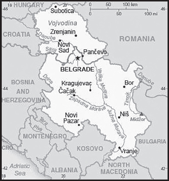
INTRODUCTION
Background: The Kingdom of Serbs, Croats, and Slovenes was formed in 1918; its name was changed to Yugoslavia in 1929. Communist Partisans resisted the Axis occupation and division of Yugoslavia from 1941 to 1945 and fought nationalist opponents and collaborators as well. The military and political movement headed by Josip Broz “TITO” (Partisans) took full control of Yugoslavia when their domestic rivals and the occupiers were defeated in 1945. Although communists, TITO and his successors (Tito died in 1980) managed to steer their own path between the Warsaw Pact nations and the West for the next four and a half decades. In 1989, Slobodan MILOSEVIC became president of the Republic of Serbia and his ultranationalist calls for Serbian domination led to the violent breakup of Yugoslavia along ethnic lines. In 1991, Croatia, Slovenia, and Macedonia declared independence, followed by Bosnia in 1992. The remaining republics of Serbia and Montenegro declared a new Federal Republic of Yugoslavia (FRY) in April 1992 and under MILOSEVIC’s leadership, Serbia led various military campaigns to unite ethnic Serbs in neighboring republics into a “Greater Serbia.” These actions ultimately failed and, after international intervention, led to the signing of the Dayton Peace Accords in 1995.
MILOSEVIC retained control over Serbia and eventually became president of the FRY in 1997. In 1998, an ethnic Albanian insurgency in the formerly autonomous Serbian province of Kosovo provoked a Serbian counterinsurgency campaign that resulted in massacres and massive expulsions of ethnic Albanians living in Kosovo. The MILOSEVIC government’s rejection of a proposed international settlement led to NATO’s bombing of Serbia in the spring of 1999. Serbian military and police forces withdrew from Kosovo in June 1999, and the UN Security Council authorized an interim UN administration and a NATO-led security force in Kosovo. FRY elections in late 2000 led to the ouster of MILOSEVIC and the installation of democratic government. In 2003, the FRY became the State Union of Serbia and Montenegro, a loose federation of the two republics. Widespread violence predominantly targeting ethnic Serbs in Kosovo in March 2004 led to more intense calls to address Kosovo’s status, and the UN began facilitating status talks in 2006. In June 2006, Montenegro seceded from the federation and declared itself an independent nation. Serbia subsequently gave notice that it was the successor state to the union of Serbia and Montenegro.
In February 2008, after nearly two years of inconclusive negotiations, Kosovo declared itself independent of Serbia - an action Serbia refuses to recognize. At Serbia’s request, the UN General Assembly (UNGA) in October 2008 sought an advisory opinion from the International Court of Justice (ICJ) on whether Kosovo’s unilateral declaration of independence was in accordance with international law. In a ruling considered unfavorable to Serbia, the ICJ issued an advisory opinion in July 2010 stating that international law did not prohibit declarations of independence. In late 2010, Serbia agreed to an EU-drafted UNGA Resolution acknowledging the ICJ’s decision and calling for a new round of talks between Serbia and Kosovo, this time on practical issues rather than Kosovo’s status. Serbia and Kosovo signed the first agreement of principles governing the normalization of relations between the two countries in April 2013 and are in the process of implementing its provisions. In 2015, Serbia and Kosovo reached four additional agreements within the EU-led Brussels Dialogue framework. These included agreements on the Community of Serb-Majority Municipalities; telecommunications; energy production and distribution; and freedom of movement. President Aleksandar VUCIC has promoted an ambitious goal of Serbia joining the EU by 2025. Under his leadership as prime minister, in 2014 Serbia opened formal negotiations for accession. In 2023, VUCIC and Kosovan Prime Minister Albin KURTI verbally agreed on the Implementation Annex to the Agreement of the Path to Normalization of Relations between Kosovo and Serbia.
GEOGRAPHY
Location: Southeastern Europe, between Macedonia and Hungary
Geographic coordinates: 44 00 N, 21 00 E
Map references: Europe
Area: total: 77,474 sq km
land: 77,474 sq km
water: 0 sq km
comparison ranking: total 117
Area - comparative: slightly smaller than South Carolina
Land boundaries: total: 2,322 km
border countries (8): Bosnia and Herzegovina 345 km; Bulgaria 344 km; Croatia 314 km; Hungary 164 km; Kosovo 366 km; North Macedonia 101 km; Montenegro 157 km; Romania 531 km
Coastline: 0 km (landlocked)
Maritime claims: none (landlocked)
Climate: in the north, continental climate (cold winters and hot, humid summers with well-distributed rainfall); in other parts, continental and Mediterranean climate (relatively cold winters with heavy snowfall and hot, dry summers and autumns)
Terrain: extremely varied; to the north, rich fertile plains; to the east, limestone ranges and basins; to the southeast, ancient mountains and hills
Elevation: highest point: Midzor 2,169 m
lowest point: Danube and Timok Rivers 35 m
mean elevation: 442 m
Natural resources: oil, gas, coal, iron ore, copper, zinc, antimony, chromite, gold, silver, magnesium, pyrite, limestone, marble, salt, arable land
Land use: agricultural land: 57.9% (2018 est.)
arable land: 37.7% (2018 est.)
permanent crops: 3.4% (2018 est.)
permanent pasture: 16.8% (2018 est.)
forest: 31.6% (2018 est.)
other: 10.5% (2018 est.)
Irrigated land: 520 sq km (2020)
Major rivers (by length in km): Dunav (Danube) (shared with Germany [s], Austria, Slovakia, Czechia, Hungary, Croatia, Bulgaria, Ukraine, Moldova, and Romania [m]) - 2,888 km
note – [s] after country name indicates river source; [m] after country name indicates river mouth
Major watersheds (area sq km): Atlantic Ocean drainage: (Black Sea) Danube (795,656 sq km)
Population distribution: a fairly even distribution throughout most of the country, with urban areas attracting larger and denser populations
Natural hazards: destructive earthquakes
Geography - note: landlocked; controls one of the major land routes from Western Europe to Turkey and the Near East
PEOPLE AND SOCIETY
Population: 6,693,375 (2023 est.)
note: does not include the population of Kosovo
comparison ranking: 108
Nationality: noun: Serb(s)
adjective: Serbian
Ethnic groups: Serb 83.3%, Hungarian 3.5%, Romani 2.1%, Bosniak 2%, other 5.7%, undeclared or unknown 3.4% (2011 est.)
note: most ethnic Albanians boycotted the 2011 census; Romani populations are usually underestimated in official statistics and may represent 5–11% of Serbia’s population
Languages: Serbian (official) 88.1%, Hungarian 3.4%, Bosnian 1.9%, Romani 1.4%, other 3.4%, undeclared or unknown 1.8%; note - Serbian, Hungarian, Slovak, Romanian, Croatian, and Ruthenian (Rusyn) are official in the Autonomous Province of Vojvodina; most ethnic Albanians boycotted the 2011 census (2011 est.)
major-language sample(s):
Knjiga svetskih činjenica, neophodan izvor osnovnih informacija. (Serbian)
Religions: Orthodox 84.6%, Catholic 5%, Muslim 3.1%, Protestant 1%, atheist 1.1%, other 0.8% (includes agnostics, other Christians, Eastern, Jewish), undeclared or unknown 4.5% (2011 est.)
note: most ethnic Albanians boycotted the 2011 census
Age structure: 0-14 years: 14.45% (male 498,534/female 468,853)
15-64 years: 65.81% (male 2,216,701/female 2,188,267)
65 years and over: 19.74% (2023 est.) (male 547,344/female 773,676)
Dependency ratios: total dependency ratio: 53.8
youth dependency ratio: 21.9
elderly dependency ratio: 31.9
potential support ratio: 3.1 (2021 est.)
note: data include Kosovo
Median age: total: 43.7 years (2023 est.)
male: 42.2 years
female: 45.2 years
comparison ranking: total 34
Population growth rate: -0.63% (2023 est.)
comparison ranking: 225
Birth rate: 8.9 births/1,000 population (2023 est.)
comparison ranking: 201
Death rate: 15.1 deaths/1,000 population (2023 est.)
comparison ranking: 3
Net migration rate: 0 migrant(s)/1,000 population (2023 est.)
comparison ranking: 85
Population distribution: a fairly even distribution throughout most of the country, with urban areas attracting larger and denser populations
Urbanization: urban population: 57.1% of total population (2023)
rate of urbanization: 0.04% annual rate of change (2020-25 est.)
note: data include Kosovo
Major urban areas - population: 1.408 million BELGRADE (capital) (2023)
Sex ratio: at birth: 1.06 male(s)/female
0-14 years: 1.06 male(s)/female
15-64 years: 1.01 male(s)/female
65 years and over: 0.71 male(s)/female
total population: 0.95 male(s)/female (2023 est.)
Mother’s mean age at first birth: 28.2 years (2020 est.)
note: data does not cover Kosovo or Metohija
Maternal mortality ratio: 10 deaths/100,000 live births (2020 est.)
comparison ranking: 143
Infant mortality rate: total: 4.6 deaths/1,000 live births (2023 est.)
male: 5.1 deaths/1,000 live births
female: 3.9 deaths/1,000 live births
comparison ranking: total 181
Life expectancy at birth: total population: 75.1 years (2023 est.)
male: 72.5 years
female: 77.9 years
comparison ranking: total population 126
Total fertility rate: 1.46 children born/woman (2023 est.)
comparison ranking: 203
Gross reproduction rate: 0.71 (2023 est.)
Contraceptive prevalence rate: 62.3% (2019)
Drinking water source: improved: urban: 99.7% of population
rural: 99.4% of population
total: 99.5% of population
unimproved: urban: 0.3% of population
rural: 0.6% of population
total: 0.5% of population (2020 est.)
Current health expenditure: 8.7% of GDP (2020)
Physicians density: 3.11 physicians/1,000 population (2016)
Hospital bed density: 5.6 beds/1,000 population (2017)
Sanitation facility access: improved: urban: 99.6% of population
rural: 95.7% of population
total: 97.9% of population
unimproved: urban: 0.4% of population
rural: 4.3% of population
total: 2.1% of population (2020 est.)
Major infectious diseases: degree of risk: intermediate (2023)
food or waterborne diseases: bacterial diarrhea
vectorborne diseases: Crimean-Congo hemorrhagic fever
Obesity - adult prevalence rate: 21.5% (2016)
comparison ranking: 88
Alcohol consumption per capita: total: 7.45 liters of pure alcohol (2019 est.)
beer: 3.24 liters of pure alcohol (2019 est.)
wine: 1.62 liters of pure alcohol (2019 est.)
spirits: 2.37 liters of pure alcohol (2019 est.)
other alcohols: 0.22 liters of pure alcohol (2019 est.)
comparison ranking: total 55
Tobacco use: total: 39.8% (2020 est.)
male: 40.5% (2020 est.)
female: 39.1% (2020 est.)
comparison ranking: total 4
Children under the age of 5 years underweight: 1% (2019)
comparison ranking: 116
Currently married women (ages 15-49): 60.8% (2023 est.)
Child marriage: women married by age 15: 1.2%
women married by age 18: 5.5% (2019 est.)
Education expenditures: 3.6% of GDP (2019 est.)
comparison ranking: 134
Literacy: definition: age 15 and over can read and write
total population: 99.5%
male: 99.9%
female: 99.1% (2019)
School life expectancy (primary to tertiary education): total: 14 years
male: 14 years
female: 15 years (2021)
Youth unemployment rate (ages 15-24): total: 30.4% (2021 est.)
male: 28.5%
female: 33.7%
comparison ranking: total 38
ENVIRONMENT
Environment - current issues: air pollution around Belgrade and other industrial cities; water pollution from industrial wastes dumped into the Sava which flows into the Danube; inadequate management of domestic, industrial, and hazardous waste
Environment - international agreements: party to: Air Pollution, Air Pollution-Heavy Metals, Air Pollution-Persistent Organic Pollutants, Biodiversity, Climate Change, Climate Change-Kyoto Protocol, Climate Change-Paris Agreement, Comprehensive Nuclear Test Ban, Desertification, Endangered Species, Hazardous Wastes, Law of the Sea, Marine Dumping-London Convention, Marine Life Conservation, Nuclear Test Ban, Ozone Layer Protection, Ship Pollution, Wetlands
signed, but not ratified: none of the selected agreements
Climate: in the north, continental climate (cold winters and hot, humid summers with well-distributed rainfall); in other parts, continental and Mediterranean climate (relatively cold winters with heavy snowfall and hot, dry summers and autumns)
Land use: agricultural land: 57.9% (2018 est.)
arable land: 37.7% (2018 est.)
permanent crops: 3.4% (2018 est.)
permanent pasture: 16.8% (2018 est.)
forest: 31.6% (2018 est.)
other: 10.5% (2018 est.)
Urbanization: urban population: 57.1% of total population (2023)
rate of urbanization: 0.04% annual rate of change (2020-25 est.)
note: data include Kosovo
Revenue from forest resources: 0.38% of GDP (2018 est.)
comparison ranking: 73
Revenue from coal: 0.25% of GDP (2018 est.)
comparison ranking: 20
Air pollutants: particulate matter emissions: 21.74 micrograms per cubic meter (2019 est.)
carbon dioxide emissions: 45.22 megatons (2016 est.)
methane emissions: 11.96 megatons (2020 est.)
Waste and recycling: municipal solid waste generated annually: 1.84 million tons (2015 est.)
municipal solid waste recycled annually: 13,984 tons (2015 est.)
percent of municipal solid waste recycled: 0.8% (2015 est.)
Major rivers (by length in km): Dunav (Danube) (shared with Germany [s], Austria, Slovakia, Czechia, Hungary, Croatia, Bulgaria, Ukraine, Moldova, and Romania [m]) - 2,888 km
note – [s] after country name indicates river source; [m] after country name indicates river mouth
Major watersheds (area sq km): Atlantic Ocean drainage: (Black Sea) Danube (795,656 sq km)
Total water withdrawal: municipal: 680 million cubic meters (2020 est.)
industrial: 3.99 billion cubic meters (2020 est.)
agricultural: 660 million cubic meters (2020 est.)
Total renewable water resources: 162.2 billion cubic meters (2020 est.) (note - includes Kosovo)
GOVERNMENT
Country name: conventional long form: Republic of Serbia
conventional short form: Serbia
local long form: Republika Srbija
local short form: Srbija
former: People’s Republic of Serbia, Socialist Republic of Serbia
etymology: the origin of the name is uncertain, but seems to be related to the name of the West Slavic Sorbs who reside in the Lusatian region in present-day eastern Germany; by tradition, the Serbs migrated from that region to the Balkans in about the 6th century A.D.
Government type: parliamentary republic
Capital: name: Belgrade (Beograd)
geographic coordinates: 44 50 N, 20 30 E
time difference: UTC+1 (6 hours ahead of Washington, DC, during Standard Time)
daylight saving time: +1hr, begins last Sunday in March; ends last Sunday in October
etymology: the Serbian “Beograd” means “white fortress” or “white city” and dates back to the 9th century; the name derives from the white fortress wall that once enclosed the city
Administrative divisions: 117 municipalities (opstine, singular - opstina) and 28 cities (gradovi, singular - grad)
municipalities: Ada*, Aleksandrovac, Aleksinac, Alibunar*, Apatin*, Arandelovac, Arilje, Babusnica, Bac*, Backa Palanka*, Backa Topola*, Backi Petrovac*, Bajina Basta, Batocina, Becej*, Bela Crkva*, Bela Palanka, Beocin*, Blace, Bogatic, Bojnik, Boljevac, Bosilegrad, Brus, Bujanovac, Cajetina, Cicevac, Coka*, Crna Trava, Cuprija, Despotovac, Dimitrov, Doljevac, Gadzin Han, Golubac, Gornji Milanovac, Indija*, Irig*, Ivanjica, Kanjiza*, Kladovo, Knic, Knjazevac, Koceljeva, Kosjeric, Kovacica*, Kovin*, Krupanj, Kucevo, Kula*, Kursumlija, Lajkovac, Lapovo, Lebane, Ljig, Ljubovija, Lucani, Majdanpek, Mali Idos*, Mali Zvornik, Malo Crnice, Medveda, Merosina, Mionica, Negotin, Nova Crnja*, Nova Varos, Novi Becej*, Novi Knezevac*, Odzaci*, Opovo*, Osecina, Paracin, Pecinci*, Petrovac na Mlavi, Plandiste*, Pozega, Presevo, Priboj, Prijepolje, Raca, Raska, Razanj, Rekovac, Ruma*, Secanj*, Senta*, Sid*, Sjenica, Smederevska Palanka, Sokobanja, Srbobran*, Sremski Karlovci*, Stara Pazova*, Surdulica, Svilajnac, Svrljig, Temerin*, Titel*, Topola, Trgoviste, Trstenik, Tutin, Ub, Varvarin, Velika Plana, Veliko Gradiste, Vladicin Han, Vladimirci, Vlasotince, Vrbas*, Vrnjacka Banja, Zabalj*, Zabari, Zagubica, Zitiste*, Zitorada
cities: Beograd (Belgrade), Bor, Cacak, Jagodina, Kikinda*, Kragujevac, Kraljevo, Krusevac, Leskovac, Loznica, Nis, Novi Pazar, Novi Sad*, Pancevo*, Pirot, Pozarevac, Prokuplje, Sabac, Smederevo, Sombor*, Sremska Mitrovica*, Subotica*, Uzice, Valjevo, Vranje, Vrsac*, Zajecar, Zrenjanin*
note: the northern 37 municipalities and 8 cities - about 28% of Serbia’s area - compose the Autonomous Province of Vojvodina and are indicated with *
Independence: 5 June 2006 (from the State Union of Serbia and Montenegro); notable earlier dates: 1217 (Serbian Kingdom established); 16 April 1346 (Serbian Empire established); 13 July 1878 (Congress of Berlin recognizes Serbian independence); 1 December 1918 (Kingdom of Serbs, Croats, and Slovenes (Yugoslavia) established)
National holiday: Statehood Day, 15 February (1835), the day the first constitution of the country was adopted
Constitution: history: many previous; latest adopted 30 September 2006, approved by referendum 28-29 October 2006, effective 8 November 2006
amendments: proposed by at least one third of deputies in the National Assembly, by the president of the republic, by the government, or by petition of at least 150,000 voters; passage of proposals and draft amendments each requires at least two-thirds majority vote in the Assembly; amendments to constitutional articles including the preamble, constitutional principles, and human and minority rights and freedoms also require passage by simple majority vote in a referendum
Legal system: civil law system
International law organization participation: has not submitted an ICJ jurisdiction declaration; accepts ICCt jurisdiction
Citizenship: citizenship by birth: no
citizenship by descent only: at least one parent must be a citizen of Serbia
dual citizenship recognized: yes
residency requirement for naturalization: 3 years
Suffrage: 18 years of age, 16 if employed; universal
Executive branch: chief of state: President Aleksandar VUCIC (since 31 May 2017)
head of government: Prime Minister Ana BRNABIC (since 29 June 2017)
cabinet: Cabinet elected by the National Assembly
elections/appointments: president directly elected by absolute majority popular vote in 2 rounds if needed for a 5-year term (eligible for a second term); election last held on 3 April 2022 (next to be held on 17 December 2023); prime minister elected by the National Assembly; note - on 1 November 2023 President VUCIC dissolved parliament and called for snap elections on 17 December 2023
election results:
2022: Aleksandar VUCIC reelected in first round; percent of vote - Aleksandar VUCIC (SNS) 60%, Zdravko PONOS (US) 18.9%, Milos JOVANOVIC (NADA) 6.1%, Bosko OBRADOVIC (Dveri-POKS) 4.5%, Milica DJURDJEVIC STAMENKOVSKI (SSZ) 4.3%, other 6.2%
2017: Aleksandar VUCIC elected president in first round; percent of vote - Aleksandar VUCIC (SNS) 55.1%, Sasa JANKOVIC (independent) 16.4%, Luka MAKSIMOVIC (independent) 9.4%, Vuk JEREMIC (independent) 5.7%, Vojislav SESELJ (SRS) 4.5%, other 7.3%, invalid/blank 1.6%; Prime Minister Ana BRNABIC reelected by the National Assembly on 5 October 2020; National Assembly vote - NA
Legislative branch: description: unicameral National Assembly or Narodna Skupstina (250 seats; members directly elected by party list proportional representation vote in a single nationwide constituency to serve 4-year terms)
elections: last held on 3 April 2022 (next to be held in April 2026)
election results: percent of vote by party/coalition - Together We Can Do Everything 44.2%, UZPS 14.1%, Ivica Dacic - Prime Minister 11.8%, NADA 5.6%, We Must 4.9%, Dveri-POKS 3.9%, SSZ 3.8%, other 11.7%; seats by party/coalition - Together We Can Do Everything 120, UZPS 38, Ivica Dacic - Prime Minister 31, NADA 15, We Must 13, Dveri-POKS 10, SSZ 10, SVM 6, SPP 3, other 4; composition - men 150, women 100, percent of women 40%
Judicial branch: highest court(s): Supreme Court of Cassation (consists of 36 judges, including the court president); Constitutional Court (consists of 15 judges, including the court president and vice president)
judge selection and term of office: Supreme Court justices proposed by the High Judicial Council (HJC), an 11- member independent body consisting of 8 judges elected by the National Assembly and 3 ex-officio members; justices appointed by the National Assembly; Constitutional Court judges elected - 5 each by the National Assembly, the president, and the Supreme Court of Cassation; initial appointment of Supreme Court judges by the HJC is 3 years and beyond that period tenure is permanent; Constitutional Court judges elected for 9-year terms
subordinate courts: basic courts, higher courts, appellate courts; courts of special jurisdiction include the Administrative Court, commercial courts, and misdemeanor courts
Political parties and leaders: Albanian Democratic Alternative (coalition of ethnic Albanian parties) [Shaip KAMBERI]
Alliance of Vojvodina Hungarians or SVM or VMSZ [Istvan PASZTOR]
Better Serbia or BS [Dragan JOVANOVIC]
Democratic Party or DS [Zoran LUTOVAC]
Dveri [Bosko OBRADOVIC]
Greens of Serbia or ZS [Ivan KARIC]
Ivica Dacic - Prime Minister of Serbia [Ivica DACIC] (electoral coalition includes SPS, JS, ZS)
Justice and Reconciliation Party or SPP [Usame ZUKORLIC] (formerly Bosniak Democratic Union of Sandzak or BDZS)
Movement for the Restoration of the Kingdom of Serbia or POKS [Vojislav MIHAILOVIC]
Movement of Free Citizens or PSG [Pavle GRBOVIC]
Movement of Socialists or PS [Aleksandar VULIN]
National Democratic Alternative or NADA [Milos JOVANOVIC and Vojislav MIHAILOVIC] (coalition includes DSS and POKS)
New Democratic Party of Serbia or NDSS or New DSS [Milos JOVANOVIC] (formerly Democratic Party of Serbia or DSS)
Party of Democratic Action of the Sandzak or SDA [Sulejman UGLJANIN]
Party of Freedom and Justice or SSP [Dragan DJILAS]
Party of United Pensioners, Farmers, and Proletarians of Serbia – Solidarity and Justice or PUPS - Solidarity and Justice [Milan KRKOBABIC] (formerly Party of United Pensioners of Serbia or PUPS)
People’s Party or NS or Narodna [Vuk JEREMIC]
People’s Peasant Party or NSS [Marijan RISTICEVIC]
Serbian Party Oathkeepers or SSZ [Milica DJURDJEVIC STAMENKOVSKI]
Serbian People’s Party or SNP [Nenad POPOVIC]
Serbian Progressive Party or SNS [Miloš VUCEVIC]
Serbian Renewal Movement or SPO [Vuk DRASKOVIC]
Social Democratic Party of Serbia or SDPS [Rasim LJAJIC]
Socialist Party of Serbia or SPS [Ivica DACIC]
Strength of Serbia or PSS [Bogoljub KARIC]
Together for Serbia or ZZS [Nebojsa ZELENOVIC]
Together We Can Do Everything [Milenko JOVANOV] (electoral coalition includes SNS, SDPS, PUPS, PSS, SNP, SPO, PS, NSS, USS, BS)
United for the Victory of Serbia or UZPS (includes NS, SSP, DS, PSG) (dissolved April 2022)
United Peasant Party or USS [Milija MILETIC]
United Serbia or JS [Dragan MARKOVIC]
We Must or Moramo [Nebojsa ZELENOVIC, Dobrica VESELINOVIC, Aleksandar JOVANOVIC CUTA, Biljana STOJKOVIC, Radomir LAZOVIC, Biljana DORDEVIC]
note: Serbia has more than 110 registered political parties and citizens’ associations
International organization participation: BIS, BSEC, CD, CE, CEI, EAPC, EBRD, EU (candidate country), FAO, G-9, IAEA, IBRD, ICAO, ICC (national committees), ICCt, ICRM, IDA, IFC, IFRCS, IHO, ILO, IMF, IMO, IMSO, Interpol, IOC, IOM, IPU, ISO, ITSO, ITU, ITUC (NGOs), MIGA, MONUSCO, NAM (observer), NSG, OAS (observer), OIF (observer), OPCW, OSCE, PCA, PFP, SELEC, UN, UNCTAD, UNESCO, UNFICYP, UNHCR, UNIDO, UNIFIL, UNMIL, UNOCI, UNTSO, UNWTO, UPU, WCO, WHO, WIPO, WMO, WTO (observer)
note: Serbia is an EU candidate country whose satisfactory completion of accession criteria is required before being granted full EU membership
Diplomatic representation in the US: chief of mission: Ambassador Marko DJURIC (since 18 January 2021)
chancery: 1333 16th Street, NW Washington, D.C. 20036
telephone: [1] (202) 507-8654; [1] (202) 332-0333
FAX: [1] (202) 332-3933
email address and website:
http://www.washington.mfa.gov.rs/
consulate(s) general: Chicago, New York
Diplomatic representation from the US: chief of mission: Ambassador Christopher R. HILL (since 1 April 2022)
embassy: 92 Bulevar kneza Aleksandra Karadjordjevica, 11040 Belgrade
mailing address: 5070 Belgrade Place, Washington, DC 20521-5070
telephone: [381] (11) 706-4000
FAX: [381] (11) 706-4481
email address and website:
Flag description: three equal horizontal stripes of red (top), blue, and white - the Pan-Slav colors representing freedom and revolutionary ideals; charged with the coat of arms of Serbia shifted slightly to the hoist side; the principal field of the coat of arms represents the Serbian state and displays a white two-headed eagle on a red shield; a smaller red shield on the eagle represents the Serbian nation, and is divided into four quarters by a white cross; interpretations vary as to the meaning and origin of the white, curved symbols resembling firesteels (fire strikers) or Cyrillic “C’s” in each quarter; a royal crown surmounts the coat of arms
note: the Pan-Slav colors were inspired by the 19th-century flag of Russia
National symbol(s): white double-headed eagle; national colors: red, blue, white
National anthem: name: “Boze pravde” (God of Justice)
lyrics/music: Jovan DORDEVIC/Davorin JENKO
note: adopted 1904; song originally written as part of a play in 1872 and has been used as an anthem by the Serbian people throughout the 20th and 21st centuries
National heritage: total World Heritage Sites: 4 (all cultural)
selected World Heritage Site locales: Stari Ras and Sopoćani; Studenica Monastery; Gamzigrad-Romuliana, Palace of Galerius; Stećci Medieval Tombstone Graveyards
ECONOMY
Economic overview: upper middle-income Balkan economy; current EU accession candidate; hit by COVID-19; pursuing green growth development; manageable public debt; new anticorruption efforts; falling unemployment; historic Russian relations; energy import-dependent
Real GDP (purchasing power parity): $135.534 billion (2021 est.)
$126.019 billion (2020 est.)
$127.168 billion (2019 est.)
note: data are in 2017 dollars
comparison ranking: 82
Real GDP growth rate: 7.55% (2021 est.)
-0.9% (2020 est.)
4.33% (2019 est.)
comparison ranking: 49
Real GDP per capita: $19,800 (2021 est.)
$18,300 (2020 est.)
$18,300 (2019 est.)
note: data are in 2017 dollars
comparison ranking: 92
GDP (official exchange rate): $51.449 billion (2019 est.)
Inflation rate (consumer prices): 4.09% (2021 est.)
1.58% (2020 est.)
1.85% (2019 est.)
comparison ranking: 88
Credit ratings: Fitch rating: BB+ (2019)
Moody’s rating: Ba3 (2017)
Standard & Poors rating: BB+ (2019)
note: The year refers to the year in which the current credit rating was first obtained.
GDP - composition, by sector of origin: agriculture: 9.8% (2017 est.)
industry: 41.1% (2017 est.)
services: 49.1% (2017 est.)
comparison rankings: services 184; industry 24; agriculture 91
GDP - composition, by end use: household consumption: 78.2% (2017 est.)
government consumption: 10.1% (2017 est.)
investment in fixed capital: 18.5% (2017 est.)
investment in inventories: 2% (2017 est.)
exports of goods and services: 52.5% (2017 est.)
imports of goods and services: -61.3% (2017 est.)
Agricultural products: maize, wheat, sugar beet, milk, sunflower seed, potatoes, soybeans, plums/sloes, apples, barley
Industries: automobiles, base metals, furniture, food processing, machinery, chemicals, sugar, tires, clothes, pharmaceuticals
Industrial production growth rate: 8.63% (2021 est.)
comparison ranking: 40
Labor force: 3.176 million (2021 est.)
comparison ranking: 102
Labor force - by occupation: agriculture: 19.4%
industry: 24.5%
services: 56.1% (2017 est.)
Unemployment rate: 11.81% (2021 est.)
9.01% (2020 est.)
10.39% (2019 est.)
comparison ranking: 58
Youth unemployment rate (ages 15-24): total: 30.4% (2021 est.)
male: 28.5%
female: 33.7%
comparison ranking: total 38
Population below poverty line: 23.2% (2018 est.)
Gini Index coefficient - distribution of family income: 34.5 (2019 est.)
comparison ranking: 107
Average household expenditures: on food: 25.6% of household expenditures (2018 est.)
on alcohol and tobacco: 7% of household expenditures (2018 est.)
Household income or consumption by percentage share: lowest 10%: 2.2%
highest 10%: 23.8% (2011)
Budget: revenues: $21.858 billion (2020 est.)
expenditures: $25.72 billion (2020 est.)
note: data include both central government and local goverment budgets
Budget surplus (+) or deficit (-): 0.2% (of GDP) (2017 est.)
comparison ranking: 43
Public debt: 62.5% of GDP (2017 est.)
73.1% of GDP (2016 est.)
comparison ranking: 78
Taxes and other revenues: 23.49% (of GDP) (2020 est.)
comparison ranking: 60
Current account balance: -$2.742 billion (2021 est.)
-$2.177 billion (2020 est.)
-$3.535 billion (2019 est.)
comparison ranking: 168
Exports: $33.726 billion (2021 est.) note: data are in current year dollars
$25.5 billion (2020 est.) note: data are in current year dollars
$26.127 billion (2019 est.) note: data are in current year dollars
comparison ranking: 72
Exports - partners: Germany 12%, Italy 10%, Bosnia and Herzegovina 7%, Romania 6%, Russia 5% (2019)
Exports - commodities: insulated wiring, tires, corn, cars, iron products, copper (2019)
Imports: $39.039 billion (2021 est.) note: data are in current year dollars
$30.177 billion (2020 est.) note: data are in current year dollars
$31.286 billion (2019 est.) note: data are in current year dollars
comparison ranking: 69
Imports - partners: Germany 13%, Russia 9%, Italy 8%, Hungary 6%, China 5%, Turkey 5% (2019)
Imports - commodities: crude petroleum, cars, packaged medicines, natural gas, refined petroleum (2019)
Reserves of foreign exchange and gold: $18.617 billion (31 December 2021 est.)
$16.587 billion (31 December 2020 est.)
$14.995 billion (31 December 2019 est.)
comparison ranking: 68
Debt - external: $30.927 billion (2019 est.)
$30.618 billion (2018 est.)
comparison ranking: 82
Exchange rates: Serbian dinars (RSD) per US dollar -
Exchange rates:
99.396 (2021 est.)
103.163 (2020 est.)
105.25 (2019 est.)
100.175 (2018 est.)
107.759 (2017 est.)
ENERGY
Electricity access: electrification - total population: 100% (2021)
Electricity: installed generating capacity: 8.986 million kW (2020 est.)
consumption: 29,933,262,000 kWh (2019 est.)
exports: 5.943 billion kWh (2020 est.)
imports: 5.002 billion kWh (2020 est.)
transmission/distribution losses: 4.332 billion kWh (2019 est.)
comparison rankings: imports 39; exports 33; installed generating capacity 69; transmission/distribution losses 51; consumption 65
Electricity generation sources: fossil fuels: 69.2% of total installed capacity (2020 est.)
wind: 2.9% of total installed capacity (2020 est.)
hydroelectricity: 27.3% of total installed capacity (2020 est.)
biomass and waste: 0.5% of total installed capacity (2020 est.)
Coal: production: 39.673 million metric tons (2020 est.)
consumption: 40.83 million metric tons (2020 est.)
exports: 72,000 metric tons (2020 est.)
imports: 987,000 metric tons (2020 est.)
proven reserves: 7.514 billion metric tons (2019 est.)
Petroleum: total petroleum production: 15,200 bbl/day (2021 est.)
refined petroleum consumption: 79,200 bbl/day (2019 est.)
crude oil and lease condensate exports: 200 bbl/day (2018 est.)
crude oil and lease condensate imports: 53,800 bbl/day (2018 est.)
crude oil estimated reserves: 77.5 million barrels (2021 est.)
Refined petroleum products - production: 74,350 bbl/day (2015 est.)
comparison ranking: 71
Refined petroleum products - exports: 15,750 bbl/day (2015 est.)
comparison ranking: 73
Refined petroleum products - imports: 18,720 bbl/day (2015 est.)
comparison ranking: 126
Natural gas: production: 455.787 million cubic meters (2019 est.)
consumption: 2,619,191,000 cubic meters (2019 est.)
exports: 0 cubic meters (2021 est.)
imports: 1,980,647,000 cubic meters (2019 est.)
proven reserves: 48.139 billion cubic meters (2021 est.)
Carbon dioxide emissions: 47.735 million metric tonnes of CO2 (2019 est.)
from coal and metallurgical coke: 32.686 million metric tonnes of CO2 (2019 est.)
from petroleum and other liquids: 10.17 million metric tonnes of CO2 (2019 est.)
from consumed natural gas: 4.878 million metric tonnes of CO2 (2019 est.)
comparison ranking: total emissions 60
Energy consumption per capita: 98.195 million Btu/person (2019 est.)
comparison ranking: 62
COMMUNICATIONS
Telephones - fixed lines: total subscriptions: 2,540,276 (2021 est.)
subscriptions per 100 inhabitants: 37 (2021 est.)
comparison ranking: total subscriptions 48
Telephones - mobile cellular: total subscriptions: 8,501,519 (2021 est.)
subscriptions per 100 inhabitants: 124 (2021 est.)
comparison ranking: total subscriptions 97
Telecommunication systems: general assessment: Serbia’s telecom industry has been liberalized in line with the principles of the EU’s regulatory framework for communications, focused on encouraging competition in telecom products and services, and ensuring universal access; considerable network investment has been undertaken in Serbia by incumbent and alternative operators in recent years, despite economic difficulties; this has helped to stimulate internet usage, which has also been bolstered by improved affordability as prices are reduced through competition; the pandemic has stimulated consumer take up of services, particularly mobile data; the government’s various initiatives to improve rural broadband availability have also been supported by European development loans; Serbia’s high mobile services, partly the result of multiple SIM card use, has weighed on revenue growth in recent years, placing further pressure on operators to develop business models which encourage consumer use of mobile data services also in response to the continued substitution of fixed-line for mobile voice calls; the regulator has yet to auction 5G-suitable frequencies, though operators are already investing in their networks in preparation for this next growth frontier; during 2021 the regulator resumed the process towards a 5G spectrum auction, which had been delayed owing to the onset of the covid-19 pandemic (2022)
domestic: fixed-line over 37 per 100 and mobile-cellular is 124 per 100 persons (2021)
international: country code - 381
Internet country code: .rs
Internet users: total: 5.589 million (2021 est.)
percent of population: 81% (2021 est.)
comparison ranking: total 85
Broadband - fixed subscriptions: total: 1,730,496 (2020 est.)
subscriptions per 100 inhabitants: 25 (2020 est.)
comparison ranking: total 62
TRANSPORTATION
National air transport system: number of registered air carriers: 4 (2020)
inventory of registered aircraft operated by air carriers: 43
annual passenger traffic on registered air carriers: 2,262,703 (2018)
annual freight traffic on registered air carriers: 17.71 million (2018) mt-km
Civil aircraft registration country code prefix: YU
Airports: 26 (2021)
comparison ranking: total 126
Airports - with paved runways: 10
note: paved runways have a concrete or asphalt surface but not all have facilities for refueling, maintenance, or air traffic control; the length of a runway required for aircraft to safely operate depends on a number of factors including the type of aircraft, the takeoff weight (including passengers, cargo, and fuel), engine types, flap settings, landing speed, elevation of the airport, and average maximum daily air temperature; paved runways can reach a length of 5,000 m (16,000 ft.), but the “typical” length of a commercial airline runway is between 2,500-4,000 m (8,000-13,000 ft.)
Airports - with unpaved runways: 16
note: unpaved runways have a surface composition such as grass or packed earth and are most suited to the operation of light aircraft; unpaved runways are usually short, often less than 1,000 m (3,280 ft.) in length; airports with unpaved runways often lack facilities for refueling, maintenance, or air traffic control
Heliports: 2 (2021)
Pipelines: 1,936 km gas, 413 km oil
Railways: total: 3,333 km (2020) 1,274 km electrified
comparison ranking: total 56
Roadways: total: 44,248 km (2016)
paved: 28,000 km (2016) (16,162 km state roads, out of which 741 km highways)
unpaved: 16,248 km (2016)
comparison ranking: total 85
Waterways: 587 km (2009) (primarily on the Danube and Sava Rivers)
comparison ranking: 87
Ports and terminals: river port(s): Belgrade (Danube)
MILITARY AND SECURITY
Military and security forces: Serbian Armed Forces (Vojska Srbije, VS): Army (aka Land Forces; includes Riverine Component, consisting of a naval flotilla on the Danube), Air and Air Defense Forces, Serbian Guard
Serbian Ministry of Interior: General Police Directorate (2023)
note: the Serbian Guard is a brigade-sized unit that is directly subordinate to the Serbian Armed Forces Chief of General Staff; its duties include safeguarding key defense facilities and rendering military honors to top foreign, state, and military officials
Military expenditures: 2.2% of GDP (2022 est.)
2.2% of GDP (2021 est.)
2% of GDP (2020 est.)
2.2% of GDP (2019 est.)
1.6% of GDP (2018 est.)
comparison ranking: 50
Military and security service personnel strengths: approximately 25,000 active-duty troops (15,000 Land Forces; 5,000 Air/Air Defense; 5,000 other); approximately 3,000 Gendarmerie (2023)
Military equipment inventories and acquisitions: the military’s inventory consists of Russian and Soviet-era weapons systems; in recent years, China and Russia have been the largest suppliers of arms to Serbia (2023)
Military service age and obligation: 18 years of age for voluntary military service for men and women; conscription abolished in 2011 (2023)
note: as of 2021, women made up about 16% of the military’s full-time personnel
Military deployments: 175 Lebanon (UNIFIL) (2023)
Military - note: the Serbian military is a professional and voluntary force responsible for defense and deterrence against external threats, supporting international peacekeeping operations, and providing support to civil authorities for internal security; specific threat concerns of the military include extremism, separatism, and deepening international recognition of Kosovo; Serbia has cooperated with NATO since 2006, when it joined the Partnership for Peace program, and the military trains with NATO countries, particularly other Balkan states; Serbia aspires to join the EU and has participated in EU peacekeeping missions, as well as missions under the Organization for Security and Cooperation in Europe and the UN; it also maintains close security ties with Russia and has a growing security relationship with China
the modern Serbian military was established in 2006 but traces its origins back through World War II, World War I, the Balkan Wars of 1912-1913, and the Bulgarian-Serb War of 1885 to the First (1804-1813) and Second (1815-1817) Uprisings against the Ottoman Empire; the military’s combat forces are organized into Army and Air and Defense commands under a General Staff, as well as some independent forces; the Army’s combat forces include four combined arms brigades and an artillery brigade, plus several independent battalions and a river flotilla; there are also independent brigades of parachute infantry, special operations, and security/guard forces, which are directly under the General Staff; the Air and Air Defense force is organized into brigades and squadrons of aircraft, air defense missiles, and early warning and surveillance; its combat aircraft include approximately 25 Russian- and Yugoslavian-made multirole and attack aircraft, as well as a force of attack and multirole helicopters (2023)
TRANSNATIONAL ISSUES
Disputes - international: Serbia-Bosnia and Herzegovina: Serbia delimited about half of the boundary with Bosnia and Herzegovina, but sections along the Drina River remain in dispute
Serbia-Bulgaria: none identified
Serbia-Croatia: Serbia and Croatia dispute their border along the Danube; Serbia claims the border is the median between the current Danube shorelines, with the land to the eastern side of the median belonging to Serbia; Croatia contends that the boundary is demarcated according to historic maps, despite the river having meandered since then
Serbia-Hungary: none identified
Serbia-Kosovo: Serbia with several other states protested the US and other states’ recognition of Kosovo’s declaration of its status as a sovereign and independent state in February 2008; ethnic Serbian municipalities along Kosovo’s northern border challenge final status of Kosovo-Serbia boundary; since 1999, NATO-led Kosovo Force peacekeepers under UN Interim Administration Mission in Kosovo (UNMIK) authority have continued to keep the peace within Kosovo between the ethnic Albanian majority and the Serb minority; in October 2021, NATO-led KFOR increased patrols along the border with Serbia to deescalate hostilities caused by a dispute over license plates
Serbia-Montenegro: the former republic boundary serves as the boundary until a line is formally delimited and demarcated
Serbia-North Macedonia: none identified
Serbia-Romania: none identified
Refugees and internally displaced persons: refugees (country of origin): 17,334 (Croatia), 7,997 (Bosnia and Herzegovina) (mid-year 2022)
IDPs: 196,066 (most are Kosovar Serbs, some are Roma, Ashkalis, and Egyptian (RAE); some RAE IDPs are unregistered) (2022)
stateless persons: 2,594 (includes stateless persons in Kosovo) (2022)
note: 1,031,608 estimated refugee and migrant arrivals (January 2015-November 2023)
Trafficking in persons: tier rating: Tier 2 Watch List — Serbia does not fully meet the minimum standards for the elimination of trafficking but is making significant efforts to do so; the government identified more victims and its Center for Protection of Trafficking Victims (CPTV) established a panel with a psychologist, educator, and social worker to conduct victim assessments within 24 hours of a referral; a court seized a house built from the profits of forced begging and gave ownership of the house to the victim as restitution; however, the government did not demonstrate overall increasing efforts, compared with the previous reporting period, to expand its anti-trafficking capacity; fewer investigations, prosecutions, and convictions of traffickers took place; officials decreased resources for the CPTV, despite its lack of staff, skills, and resources to assess victims, coordinate care, and run the CTPV shelter; standard operating procedures on victim identification remained unclear, and implementation was “recommended” rather than required; authorities inappropriately penalized victims with imprisonment, probation, and fines for unlawful acts committed as a direct result of being trafficked; the Anti-Trafficking Council has not met in three years, and the government has not adopted the 2021-2022 National Action Plan; official complicity in trafficking or inaction remained significant concerns; the government did not fully protect victims or fully investigate credible allegations that approximately 500 Vietnamese workers were subjected to forced labor at a factory owned by China; therefore, Serbia remained on Tier 2 Watch List for the second consecutive year (2023)
trafficking profile: human traffickers exploit domestic and foreign victims in Serbia, as well as Serbians abroad; Serbian women and girls are exploited in sex trafficking in Serbia, neighboring countries, and throughout Europe; Serbian nationals, primarily men, are exploited in forced labor in labor-intensive sectors, such as construction, in European countries—including Austria, Belgium, Croatia, France, Germany, Italy, Luxembourg, Montenegro, Russia, and Switzerland—and the UAE; children, particularly Roma, are victims within the country in sex trafficking, forced labor, forced begging, and petty crime; foreign victims in Serbia have been identified from Afghanistan, Albania, Bosnia Herzegovina, Cameroon, Croatia, the Democratic Republic of the Congo, Iran, Pakistan, the Philippines, Tunisia, Turkey, Uganda, and Vietnam; thousands of migrants and refugees from the Middle East, Africa, and Asia transiting through or stranded in Serbia are vulnerable to trafficking; the government has not reported fully investigating credible allegations during the past several years of Vietnamese victims of forced labor in a Chinese-owned factory and instead has stated that the workers are not trafficking victims; Chinese workers at the same factory conducted a strike during the reporting period over claims that they had not been paid (2023)
Illicit drugs: drug trafficking groups are major players in the procurement and transportation of of large quantities of cocaine destined for European markets