SEYCHELLES
INTRODUCTION
Background: Seychelles was uninhabited prior to being discovered by Europeans early in the 16th century. A lengthy struggle between France and Great Britain for the islands ended in 1814, when they were ceded to the latter. During colonial rule, a plantation-based economy developed that relied on imported labor, primarily from European colonies in Africa. Seychelles gained independence in 1976 through negotiations with Great Britain. In 1977, prime minister France-Albert RENE launched a coup against the country’s first president and Seychelles became a socialist one-party state until adopting a new constitution and holding elections in 1993. RENE continued to lead Seychelles through two election cycles until he stepped down in 2004. Vice President James Alix MICHEL took over the presidency and in 2006 was elected to a new five-year term; he was reelected in 2011 and again in 2015. In 2016, James MICHEL resigned and handed over the presidency to his vice-president, Danny FAURE. In 2020, Wavel RAMKALAWAN was elected president, the first time an opposition candidate has won the presidency.
GEOGRAPHY
Location: archipelago in the Indian Ocean, northeast of Madagascar
Geographic coordinates: 4 35 S, 55 40 E
Map references: Africa
Area: total: 455 sq km
land: 455 sq km
water: 0 sq km
comparison ranking: total 198
Area - comparative: 2.5 times the size of Washington, DC
Land boundaries: total: 0 km
Coastline: 491 km
Maritime claims: territorial sea: 12 nm
contiguous zone: 24 nm
exclusive economic zone: 200 nm
continental shelf: 200 nm or to the edge of the continental margin
Climate: tropical marine; humid; cooler season during southeast monsoon (late May to September); warmer season during northwest monsoon (March to May)
Terrain: Mahe Group is volcanic with a narrow coastal strip and rocky, hilly interior; others are relatively flat coral atolls, or elevated reefs; sits atop the submarine Mascarene Plateau
Elevation: highest point: Morne Seychellois 905 m
lowest point: Indian Ocean 0 m
Natural resources: fish, coconuts (copra), cinnamon trees
Land use: agricultural land: 6.5% (2018 est.)
arable land: 2.2% (2018 est.)
permanent crops: 4.3% (2018 est.)
permanent pasture: 0% (2018 est.)
forest: 88.5% (2018 est.)
other: 5% (2018 est.)
Irrigated land: 3 sq km (2012)
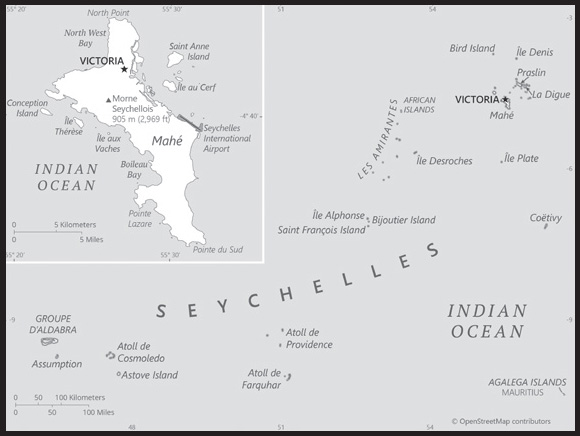
Population distribution: more than three-quarters of the population lives on the main island of Mahe; Praslin contains less than 10%; a smaller percent on La Digue and the outer islands as shown in this population distribution map
Natural hazards: lies outside the cyclone belt, so severe storms are rare; occasional short droughts
Geography - note: the smallest African country in terms of both area and population; the constitution of the Republic of Seychelles lists 155 islands: 42 granitic and 113 coralline; by far the largest island is Mahe, which is home to about 90% of the population and the site of the capital city of Victoria
PEOPLE AND SOCIETY
Population: 97,617 (2023 est.)
comparison ranking: 197
Nationality: noun: Seychellois (singular and plural)
adjective: Seychellois
Ethnic groups: predominantly Creole (mainly of East African and Malagasy heritage); also French, Indian, Chinese, and Arab populations
Languages: Seychellois Creole (official) 89.1%, English (official) 5.1%, French (official) 0.7%, other 3.8%, unspecified 1.4% (2010 est.)
Religions: Roman Catholic 76.2%, Protestant 10.5% (Anglican 6.1%, Pentecostal Assembly 1.5%, Seventh Day Adventist 1.2%, other Protestant 1.7%), other Christian 2.4%, Hindu 2.4%, Muslim 1.6%, other non-Christian 1.1%, unspecified 4.8%, none 0.9% (2010 est.)
Demographic profile: Seychelles has no indigenous population and was first permanently settled by a small group of French planters, African slaves, and South Indians in 1770. Seychelles’ modern population is composed of the descendants of French and later British settlers, Africans, and Indian, Chinese, and Middle Eastern traders and is concentrated on three of its 155 islands – the vast majority on Mahe and lesser numbers on Praslin and La Digue. Seychelles’ population grew rapidly during the second half of the 20th century, largely due to natural increase, but the pace has slowed because of fertility decline. The total fertility rate dropped sharply from 4.0 children per woman in 1980 to 1.9 in 2015, mainly as a result of a family planning program, free education and health care, and increased female labor force participation. Life expectancy has increased steadily, but women on average live 9 years longer than men, a difference that is higher than that typical of developed countries.
The combination of reduced fertility and increased longevity has resulted in an aging population, which will put pressure on the government’s provision of pensions and health care. Seychelles’ sustained investment in social welfare services, such as free primary health care and education up to the post-secondary level, have enabled the country to achieve a high human development index score – among the highest in Africa. Despite some of its health and education indicators being nearly on par with Western countries, Seychelles has a high level of income inequality.
An increasing number of migrant workers – mainly young men – have been coming to Seychelles in recent years to work in the construction and tourism industries. As of 2011, foreign workers made up nearly a quarter of the workforce. Indians are the largest non-Seychellois population – representing half of the country’s foreigners – followed by Malagasy.
Age structure: 0-14 years: 17.95% (male 8,999/female 8,524)
15-64 years: 72.58% (male 37,677/female 33,177)
65 years and over: 9.47% (2023 est.) (male 3,956/female 5,284)
Dependency ratios: total dependency ratio: 45
youth dependency ratio: 33.6
elderly dependency ratio: 11.4
potential support ratio: 8.7 (2021 est.)
Median age: total: 38.2 years (2023 est.)
male: 37.7 years
female: 38.8 years
comparison ranking: total 70
Population growth rate: 0.6% (2023 est.)
comparison ranking: 143
Birth rate: 12.1 births/1,000 population (2023 est.)
comparison ranking: 150
Death rate: 6.9 deaths/1,000 population (2023 est.)
comparison ranking: 126
Net migration rate: 0.8 migrant(s)/1,000 population (2023 est.)
comparison ranking: 72
Population distribution: more than three-quarters of the population lives on the main island of Mahe; Praslin contains less than 10%; a smaller percent on La Digue and the outer islands as shown in this population distribution map
Urbanization: urban population: 58.8% of total population (2023)
rate of urbanization: 0.99% annual rate of change (2020-25 est.)
Major urban areas - population: 28,000 VICTORIA (capital) (2018)
Sex ratio: at birth: 1.03 male(s)/female
0-14 years: 1.06 male(s)/female
15-64 years: 1.14 male(s)/female
65 years and over: 0.75 male(s)/female
total population: 1.08 male(s)/female (2023 est.)
Maternal mortality ratio: 3 deaths/100,000 live births (2020)
comparison ranking: 183
Infant mortality rate: total: 10.4 deaths/1,000 live births (2023 est.)
male: 13.1 deaths/1,000 live births
female: 7.6 deaths/1,000 live births
comparison ranking: total 131
Life expectancy at birth: total population: 76.4 years (2023 est.)
male: 72 years
female: 80.9 years
comparison ranking: total population 102
Total fertility rate: 1.81 children born/woman (2023 est.)
comparison ranking: 139
Gross reproduction rate: 0.89 (2023 est.)
Drinking water source: improved:
total: 96.2% of population
unimproved: total: 3.8% of population (2017 est.)
Current health expenditure: 6.4% of GDP (2020)
Physicians density: 2.25 physicians/1,000 population (2019)
Hospital bed density: 3.6 beds/1,000 population (2011)
Sanitation facility access: improved:
total: 100% of population
unimproved: total: 0% of population (2020 est.)
Obesity - adult prevalence rate: 14% (2016)
comparison ranking: 130
Alcohol consumption per capita: total: 9.48 liters of pure alcohol (2019 est.)
beer: 4.11 liters of pure alcohol (2019 est.)
wine: 0.49 liters of pure alcohol (2019 est.)
spirits: 4.62 liters of pure alcohol (2019 est.)
other alcohols: 0.25 liters of pure alcohol (2019 est.)
comparison ranking: total 28
Tobacco use: total: 20.2% (2020 est.)
male: 34% (2020 est.)
female: 6.4% (2020 est.)
comparison ranking: total 87
Currently married women (ages 15-49): 45% (2023 est.)
Education expenditures: 5.2% of GDP (2020 est.)
comparison ranking: 67
Literacy: definition: age 15 and over can read and write
total population: 95.9%
male: 95.4%
female: 96.4% (2018)
School life expectancy (primary to tertiary education): total: 15 years
male: 13 years
female: 16 years (2021)
Youth unemployment rate (ages 15-24): total: 16.5% (2020 est.)
male: 17.5%
female: 15.6%
comparison ranking: total 104
ENVIRONMENT
Environment - current issues: water supply depends on catchments to collect rainwater; water pollution; biodiversity maintainance
Environment - international agreements: party to: Biodiversity, Climate Change, Climate Change-Kyoto Protocol, Climate Change-Paris Agreement, Comprehensive Nuclear Test Ban, Desertification, Endangered Species, Hazardous Wastes, Law of the Sea, Marine Dumping-London Convention, Nuclear Test Ban, Ozone Layer Protection, Ship Pollution, Wetlands
signed, but not ratified: none of the selected agreements
Climate: tropical marine; humid; cooler season during southeast monsoon (late May to September); warmer season during northwest monsoon (March to May)
Land use: agricultural land: 6.5% (2018 est.)
arable land: 2.2% (2018 est.)
permanent crops: 4.3% (2018 est.)
permanent pasture: 0% (2018 est.)
forest: 88.5% (2018 est.)
other: 5% (2018 est.)
Urbanization: urban population: 58.8% of total population (2023)
rate of urbanization: 0.99% annual rate of change (2020-25 est.)
Revenue from forest resources: 0.09% of GDP (2018 est.)
comparison ranking: 116
Revenue from coal: 0% of GDP (2018 est.)
comparison ranking: 59
Air pollutants: particulate matter emissions: 16.96 micrograms per cubic meter (2019 est.)
carbon dioxide emissions: 0.61 megatons (2016 est.)
methane emissions: 0.1 megatons (2020 est.)
Waste and recycling: municipal solid waste generated annually: 48,000 tons (2012 est.)
Total water withdrawal: municipal: 10 million cubic meters (2020 est.)
industrial: 3.8 million cubic meters (2017 est.)
agricultural: 900,000 cubic meters (2017 est.)
Total renewable water resources: 0 cubic meters (2017 est.)
GOVERNMENT
Country name: conventional long form: Republic of Seychelles
conventional short form: Seychelles
local long form: Republic of Seychelles
local short form: Seychelles
etymology: named by French Captain Corneille Nicholas MORPHEY after Jean Moreau de SECHELLES, the finance minister of France, in 1756
Government type: presidential republic
Capital: name: Victoria
geographic coordinates: 4 37 S, 55 27 E
time difference: UTC+4 (9 hours ahead of Washington, DC, during Standard Time)
etymology: founded as L’etablissement in 1778 by French colonists, the town was renamed in 1841 by the British after Queen VICTORIA (1819-1901); “victoria” is the Latin word for “victory”
Administrative divisions: 27 administrative districts; Anse aux Pins, Anse Boileau, Anse Etoile, Anse Royale, Au Cap, Baie Lazare, Baie Sainte Anne, Beau Vallon, Bel Air, Bel Ombre, Cascade, Glacis, Grand Anse Mahe, Grand Anse Praslin, Ile Perseverance I, Ile Perseverance II, La Digue, La Riviere Anglaise, Les Mamelles, Mont Buxton, Mont Fleuri, Plaisance, Pointe Larue, Port Glaud, Roche Caiman, Saint Louis, Takamaka
Independence: 29 June 1976 (from the UK)
National holiday: Constitution Day, 18 June (1993); Independence Day (National Day), 29 June (1976)
Constitution: history: previous 1970, 1979; latest drafted May 1993, approved by referendum 18 June 1993, effective 23 June 1993
amendments: proposed by the National Assembly; passage requires at least two-thirds majority vote by the National Assembly; passage of amendments affecting the country’s sovereignty, symbols and languages, the supremacy of the constitution, fundamental rights and freedoms, amendment procedures, and dissolution of the Assembly also requires approval by at least 60% of voters in a referendum; amended several times, last in 2018
Legal system: mixed legal system of English common law, French civil law, and customary law
International law organization participation: has not submitted an ICJ jurisdiction declaration; accepts ICCt jurisdiction
Citizenship: citizenship by birth: no
citizenship by descent only: at least one parent must be a citizen of the Seychelles
dual citizenship recognized: no
residency requirement for naturalization: 5 years
Suffrage: 18 years of age; universal
Executive branch: chief of state: President Wavel RAMKALAWAN (since 26 October 2020); Vice President Ahmed AFIF (since 27 October 2020); the president is both chief of state and head of government
head of government: President Wavel RAMKALAWAN (since 26 October 2020); Vice President Ahmed AFIF (since 27 October 2020)
cabinet: Council of Ministers appointed by the president
elections/appointments: president directly elected by absolute majority popular vote in 2 rounds if needed for a 5-year term (eligible for a second term); election last held on 22-24 October 2020; next presidential election due in 2025
election results:
2020: Wavel RAMKALAWAN elected president; Wavel RAMKALAWAN (LDS) 54.9%, Danny FAURE (US) 43.5%, other 1.6%
2015: President James Alix MICHEL reelected president in second round; percent of vote first round - James Alix MICHEL (PL) 47.8%, Wavel RAMKALAWAN (SNP) 35.3%, other 16.9%; percent of vote second round - James Alix MICHEL 50.2%, Wavel RAMKALAWAN 49.8%
Legislative branch: description: unicameral National Assembly or Assemblee Nationale (35 seats in the 2020-25 term; 26 members directly elected in single-seat constituencies by simple majority vote and up to 9 members elected by proportional representation vote; members serve 5-year terms)
elections: last held on 22-24 October 2020 (next to be held in October 2025); note - the election was originally scheduled for 2021 but was moved up a year and held alongside the presidential election in order to cut election costs
election results: percent of vote by party - LDS 54.8%, US 42.3%, other 2.9%; seats by party - LDS 25, US 10; composition - men 27, women 8, percent of women 22.9%
Judicial branch: highest court(s): Seychelles Court of Appeal (consists of the court president and 4 justices); Supreme Court of Seychelles (consists of the chief justice and 9 puisne judges); Constitutional Court (consists of 3 Supreme Court judges)
judge selection and term of office: all judges appointed by the president of the republic upon the recommendation of the Constitutional Appointments Authority, a 3-member body, with 1 member appointed by the president of the republic, 1 by the opposition leader in the National Assembly, and 1 by the other 2 appointees; judges serve until retirement at age 70
subordinate courts: Magistrates’ Courts of Seychelles; Family Tribunal for issues such as domestic violence, child custody, and maintenance; Employment Tribunal for labor-related disputes
Political parties and leaders: Seychelles Party for Social Justice and Democracy or SPSJD [Vesna RAKIC]
Seychellois Democratic Alliance or LDS (Linyon Demokratik Seselwa/Union Démocratique Seychelloise) (coalition includes SNP and SPSJD) [Roger MANCIENNE]
Seychelles National Party or SNP [Wavel RAMKALAWAN]
United Seychelles or US [Patrick HERMINIE]
note: only parties with seats in the National Assembly listed
International organization participation: ACP, AfDB, AOSIS, AU, C, CD, COMESA, EITI (candidate country), FAO, G-77, IAEA, IBRD, ICAO, ICC (NGOs), ICCt, ICRM, IDA, IFAD, IFC, IFRCS, ILO, IMF, IMO, InOC, Interpol, IOC, IOM, IPU, ISO (correspondent), ITU, MIGA, NAM, OIF, OPCW, SADC, UN, UNCTAD, UNESCO, UNIDO, UNWTO, UPU, WCO, WHO, WIPO, WMO, WTO
Diplomatic representation in the US: chief of mission: Ambassador Ian Dereck Joseph MADELEINE (since 1 December 2021)
note - also Permanent Representative to the UN
chancery: 685 Third Avenue, Suite 1107, 11th Floor, New York, NY 10017
telephone: [1] (212) 972-1785
FAX: [1] (212) 972-1786
email address and website:
seychelles@un.int; seychellesmission@sycun.org
Foreign Affairs Department Republic of Seychelles » United States of America (mfa.gov.sc)
consulate(s) general: New York
Diplomatic representation from the US: chief of mission: Ambassador Henry V. JARDINE (since 22 February 2023); note - Ambassador JARDINE is posted in Mauritius but is accredited to Seychelles
embassy: 2nd Floor, Oliaji Trade Center, Victoria Mahe, Seychelles; note - US Embassy in Seychelles reopened on 1 June 2023 after having been closed in 1996
telephone: [248] 422 5256
Flag description: five oblique bands of blue (hoist side), yellow, red, white, and green (bottom) radiating from the bottom of the hoist side; the oblique bands are meant to symbolize a dynamic new country moving into the future; blue represents sky and sea, yellow the sun giving light and life, red the peoples’ determination to work for the future in unity and love, white social justice and harmony, and green the land and natural environment
National symbol(s): coco de mer (sea coconut); national colors: blue, yellow, red, white, green
National anthem: name: “Koste Seselwa” (Seychellois Unite)
lyrics/music: David Francois Marc ANDRE and George Charles Robert PAYET
note: adopted 1996
National heritage: total World Heritage Sites: 2 (both natural)
selected World Heritage Site locales: Aldabra Atoll; Vallée de Mai Nature Reserve
ECONOMY
Economic overview: high-income Indian Ocean island economy; rapidly growing tourism sector; major tuna exporter; offshore financial hub; environmentally fragile and investing in ocean rise mitigation; recently discovered offshore oil potential; successful anticorruption efforts
Real GDP (purchasing power parity): $2.855 billion (2021 est.)
$2.647 billion (2020 est.)
$2.867 billion (2019 est.)
note: data are in 2017 dollars
comparison ranking: 192
Real GDP growth rate: 7.86% (2021 est.)
-7.69% (2020 est.)
3.1% (2019 est.)
comparison ranking: 44
Real GDP per capita: $28,800 (2021 est.)
$26,900 (2020 est.)
$29,400 (2019 est.)
note: data are in 2017 dollars
comparison ranking: 74
GDP (official exchange rate): $1.748 billion (2019 est.)
Inflation rate (consumer prices): 8.28% (2020 est.)
2.07% (2019 est.)
3.7% (2018 est.)
comparison ranking: 34
Credit ratings: Fitch rating: B+ (2020)
note: The year refers to the year in which the current credit rating was first obtained.
GDP - composition, by sector of origin: agriculture: 2.5% (2017 est.)
industry: 13.8% (2017 est.)
services: 83.7% (2017 est.)
comparison rankings: services 23; industry 188; agriculture 160
GDP - composition, by end use: household consumption: 52.7% (2017 est.)
government consumption: 34.4% (2017 est.)
investment in fixed capital: 26.7% (2017 est.)
investment in inventories: 0% (2017 est.)
exports of goods and services: 79.4% (2017 est.)
imports of goods and services: -93.2% (2017 est.)
Agricultural products: coconuts, vegetables, bananas, fruit, eggs, poultry, tomatoes, pork, tropical fruit, cassava
Industries: fishing, tourism, beverages
Industrial production growth rate: 3.63% (2021 est.)
comparison ranking: 107
Labor force: 51,000 (2018 est.)
comparison ranking: 194
Labor force - by occupation: agriculture: 3%
industry: 23%
services: 74% (2006)
Unemployment rate: 3% (2017 est.)
2.7% (2016 est.)
comparison ranking: 195
Youth unemployment rate (ages 15-24): total: 16.5% (2020 est.)
male: 17.5%
female: 15.6%
comparison ranking: total 104
Population below poverty line: 25.3% (2018 est.)
Gini Index coefficient - distribution of family income: 32.1 (2018 est.)
comparison ranking: 135
Household income or consumption by percentage share: lowest 10%: 4.7%
highest 10%: 15.4% (2007)
Budget: revenues: $601 million (2019 est.)
expenditures: $586 million (2019 est.)
Budget surplus (+) or deficit (-): -0.5% (of GDP) (2017 est.)
comparison ranking: 63
Public debt: 63.6% of GDP (2017 est.)
69.1% of GDP (2016 est.)
comparison ranking: 73
Taxes and other revenues: 31.52% (of GDP) (2018 est.)
comparison ranking: 25
Fiscal year: calendar year
Current account balance: -$154.259 million (2021 est.)
-$173.236 million (2020 est.)
-$53.115 million (2019 est.)
comparison ranking: 96
Exports: $1.751 billion (2021 est.) note: data are in current year dollars
$1.24 billion (2020 est.) note: data are in current year dollars
$2.085 billion (2019 est.) note: data are in current year dollars
comparison ranking: 164
Exports - partners: United Arab Emirates 17%, United Kingdom 13%, France 12%, British Virgin Islands 11%, Zambia 9%, Mauritius 5%, Japan 5% (2019)
Exports - commodities: refined petroleum, fish, recreational boats, cigarettes, animal meal (2019)
Imports: $1.821 billion (2021 est.) note: data are in current year dollars
$1.332 billion (2020 est.) note: data are in current year dollars
$2.025 billion (2019 est.) note: data are in current year dollars
comparison ranking: 177
Imports - partners: United Arab Emirates 21%, Qatar 13%, British Virgin Islands 7%, Germany 6%, France 6%, China 5%, Spain 5%, South Africa 5% (2019)
Imports - commodities: recreational boats, refined petroleum, fish, aircraft, cars (2019)
Reserves of foreign exchange and gold: $702.585 million (31 December 2021 est.)
$559.682 million (31 December 2020 est.)
$580.546 million (31 December 2019 est.)
comparison ranking: 158
Debt - external: $4.802 billion (2019 est.)
$4.613 billion (2018 est.)
comparison ranking: 135
Exchange rates: Seychelles rupees (SCR) per US dollar -
Exchange rates:
16.921 (2021 est.)
17.617 (2020 est.)
14.033 (2019 est.)
13.911 (2018 est.)
13.648 (2017 est.)
ENERGY
Electricity access: electrification - total population: 100% (2021)
Electricity: installed generating capacity: 157,000 kW (2020 est.)
consumption: 463.894 million kWh (2019 est.)
exports: 0 kWh (2020 est.)
imports: 0 kWh (2020 est.)
transmission/distribution losses: 30 million kWh (2019 est.)
comparison rankings: imports 164; exports 152; installed generating capacity 177; transmission/distribution losses 178; consumption 173
Electricity generation sources: fossil fuels: 99.1% of total installed capacity (2020 est.)
solar: 0.9% of total installed capacity (2020 est.)
Petroleum: total petroleum production: 0 bbl/day (2021 est.)
refined petroleum consumption: 7,500 bbl/day (2019 est.)
Refined petroleum products - imports: 7,225 bbl/day (2015 est.)
comparison ranking: 155
Carbon dioxide emissions: 1.156 million metric tonnes of CO2 (2019 est.)
from petroleum and other liquids: 1.156 million metric tonnes of CO2 (2019 est.)
comparison ranking: total emissions 171
Energy consumption per capita: 163.06 million Btu/person (2019 est.)
comparison ranking: 29
COMMUNICATIONS
Telephones - fixed lines: total subscriptions: 18,768 (2021 est.)
subscriptions per 100 inhabitants: 18 (2021 est.)
comparison ranking: total subscriptions 175
Telephones - mobile cellular: total subscriptions: 184,161 (2021 est.)
subscriptions per 100 inhabitants: 173 (2021 est.)
comparison ranking: total subscriptions 184
Telecommunication systems: general assessment: effective system; direct international calls to over 100 countries; radiotelephone communications between islands in the archipelago; 3 ISPs; use of Internet cafes’ for access to Internet; 4G services and 5G pending (2020)
domestic: fixed-line is 18 per 100 and mobile-cellular teledensity is 173 telephones per 100 persons (2021)
international: country code - 248; landing points for the PEACE and the SEAS submarine cables providing connectivity to Europe, the Middle East, Africa and Asia; direct radiotelephone communications with adjacent island countries and African coastal countries; satellite earth station - 1 Intelsat (Indian Ocean) (2019)
Broadcast media: the national broadcaster, Seychelles Broadcasting Corporation (SBC), which is funded by taxpayer money, operates the only terrestrial TV station, which provides local programming and airs broadcasts from international services; a privately owned Internet Protocol Television (IPTV) channel also provides local programming multi-channel cable and satellite TV are available through 2 providers; the national broadcaster operates 1 AM and 1 FM radio station; there are 2 privately operated radio stations; transmissions of 2 international broadcasters are accessible in Victoria
(2019)
Internet country code: .sc
Internet users: total: 90,200 (2021 est.)
percent of population: 82% (2021 est.)
comparison ranking: total 190
Broadband - fixed subscriptions: total: 34,966 (2020 est.)
subscriptions per 100 inhabitants: 36 (2020 est.)
comparison ranking: total 148
TRANSPORTATION
National air transport system: number of registered air carriers: 1 (2020)
inventory of registered aircraft operated by air carriers: 7
annual passenger traffic on registered air carriers: 455,201 (2018)
annual freight traffic on registered air carriers: 7.79 million (2018) mt-km
Civil aircraft registration country code prefix: S7
Airports: 14 (2021)
comparison ranking: total 150
Airports - with paved runways: 7
note: paved runways have a concrete or asphalt surface but not all have facilities for refueling, maintenance, or air traffic control; the length of a runway required for aircraft to safely operate depends on a number of factors including the type of aircraft, the takeoff weight (including passengers, cargo, and fuel), engine types, flap settings, landing speed, elevation of the airport, and average maximum daily air temperature; paved runways can reach a length of 5,000 m (16,000 ft.), but the “typical” length of a commercial airline runway is between 2,500-4,000 m (8,000-13,000 ft.)
Airports - with unpaved runways: 7
note: unpaved runways have a surface composition such as grass or packed earth and are most suited to the operation of light aircraft; unpaved runways are usually short, often less than 1,000 m (3,280 ft.) in length; airports with unpaved runways often lack facilities for refueling, maintenance, or air traffic control
Heliports: 1 (2021)
Roadways: total: 526 km (2015)
paved: 514 km (2015)
unpaved: 12 km (2015)
comparison ranking: total 196
Merchant marine: total: 31 (2022)
by type: general cargo 6, oil tanker 7, other 18
comparison ranking: total 132
Ports and terminals: major seaport(s): Victoria
MILITARY AND SECURITY
Military and security forces: Seychelles Defense Forces (SDF): Army (includes infantry, special forces, and a presidential security unit), Coast Guard, and Air Force
Ministry of Internal Affairs: Seychelles Police Force (includes unarmed police and an armed paramilitary Police Special Support Wing, and the Marine Police Unit) (2023)
note: the SDF reports to the president, who acts as minister of defense
Military expenditures: 1.4% of GDP (2022 est.)
1.5% of GDP (2021 est.)
1.6% of GDP (2020 est.)
1.3% of GDP (2019 est.)
1.4% of GDP (2018 est.)
comparison ranking: 96
Military and security service personnel strengths: approximately 500-1,000 personnel (2023)
Military equipment inventories and acquisitions: the SDF’s inventory primarily consists of Soviet-era equipment delivered in the 1970s and 1980s; in recent years, the SDF has received limited amounts of more modern equipment, mostly donations of patrol boats and aircraft, from several suppliers led by China and India (2023)
Military service age and obligation: 18-28 (18-25 for officers) years of age for voluntary military service for men and women; 6-year initial commitment; no conscription (2023)
Military - note: formed in 1977, the SDF is one of the world’s smallest militaries; its primary responsibility is maritime security, particularly countering illegal fishing, piracy, and drug smuggling; it was given police powers in 2022; the Seychelles has strong security ties with India (2023)
TRANSNATIONAL ISSUES
Disputes - international: Seychelles-UK: Mauritius and Seychelles claim the Chagos Islands (UK-administered British Indian Ocean Territory)
SIERRA LEONE
INTRODUCTION
Background: Continuously populated for at least 2,500 years, the dense jungle in the area of Sierra Leone allowed the region to remain relatively protected from invaders from empires in West Africa. Traders introduced Sierra Leone to Islam, which occupies a central role in Sierra Leonean culture and history. In the 17th century, the British set up a trading post near present-day Freetown. The trade originally involved timber and ivory but later expanded to enslaved people. In 1787, following the American Revolution, Sierra Leone became a destination for Black British loyalists from the new United States. After the abolition of the slave trade in 1807, British ships delivered thousands of liberated Africans to Sierra Leone. During the 19th century, the colony gradually expanded inland.
In 1961, Sierra Leone became independent of the UK. While Sierra Leone held free and fair elections in 1962 and 1967, Siaka STEVENS - Sierra Leone’s second prime minister - quickly reverted to authoritarian tendencies, outlawing most political parties and ruling from 1967 to 1985. In 1991, Sierra Leonean soldiers launched a civil war against STEVENS’ ruling party. The war caused tens of thousands of deaths and displaced more than 2 million people (about one third of the population). In 1998, a Nigerian-led West African coalition military force intervened, installing Tejan KABBAH - who was originally elected in 1996 - as prime minister. In 2002, KABBAH officially announced the end of the war. Since 1998, Sierra Leone has conducted uninterrupted democratic elections, dominated by the two main political parties. In 2018, Julius Maada BIO of the Sierra Leone People’s Party won the presidential election that saw a high voter turnout despite some allegations of voter intimidation. The next presidential election is scheduled for June 2023.
GEOGRAPHY
Location: Western Africa, bordering the North Atlantic Ocean, between Guinea and Liberia
Geographic coordinates: 8 30 N, 11 30 W
Map references: Africa
Area: total: 71,740 sq km
land: 71,620 sq km
water: 120 sq km
comparison ranking: total 119
Area - comparative: slightly smaller than South Carolina
Land boundaries: total: 1,093 km
border countries (2): Guinea 794 km; Liberia 299 km
Coastline: 402 km
Maritime claims: territorial sea: 12 nm
contiguous zone: 24 nm
exclusive economic zone: 200 nm
continental shelf: 200 nm
Climate: tropical; hot, humid; summer rainy season (May to December); winter dry season (December to April)
Terrain: coastal belt of mangrove swamps, wooded hill country, upland plateau, mountains in east
Elevation: highest point: Loma Mansa (Bintimani) 1,948 m
lowest point: Atlantic Ocean 0 m
mean elevation: 279 m
Natural resources: diamonds, titanium ore, bauxite, iron ore, gold, chromite
Land use: agricultural land: 56.2% (2018 est.)
arable land: 23.4% (2018 est.)
permanent crops: 2.3% (2018 est.)
permanent pasture: 30.5% (2018 est.)
forest: 37.5% (2018 est.)
other: 6.3% (2018 est.)
Irrigated land: 300 sq km (2012)
Major watersheds (area sq km): Atlantic Ocean drainage: Niger (2,261,741 sq km)
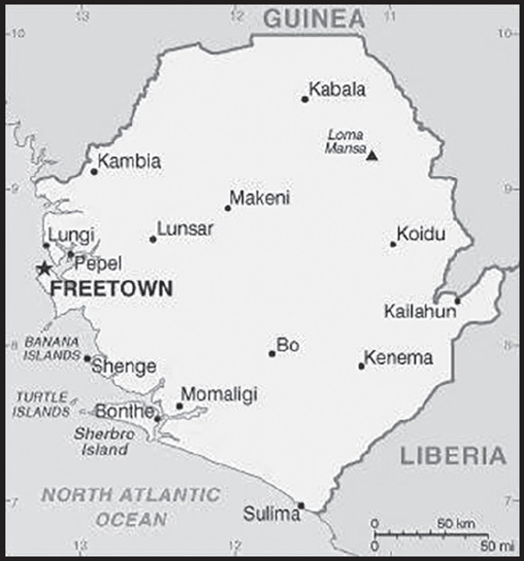
Population distribution: population clusters are found in the lower elevations of the south and west; the northern third of the country is less populated as shown on this population distribution map
Natural hazards: dry, sand-laden harmattan winds blow from the Sahara (December to February); sandstorms, dust storms
Geography - note: rainfall along the coast can reach 495 cm (195 inches) a year, making it one of the wettest places along coastal, western Africa
PEOPLE AND SOCIETY
Population: 8,908,040 (2023 est.)
comparison ranking: 100
Nationality: noun: Sierra Leonean(s)
adjective: Sierra Leonean
Ethnic groups: Temne 35.4%, Mende 30.8%, Limba 8.8%, Kono 4.3%, Korankoh 4%, Fullah 3.8%, Mandingo 2.8%, Loko 2%, Sherbro 1.9%, Creole 1.2% (descendants of freed Jamaican slaves who were settled in the Freetown area in the late-18th century; also known as Krio), other 5% (2019 est.)
Languages: English (official, regular use limited to literate minority), Mende (principal vernacular in the south), Temne (principal vernacular in the north), Krio (English-based Creole, spoken by the descendants of freed Jamaican slaves who were settled in the Freetown area, a lingua franca and a first language for 10% of the population but understood by 95%)
Religions: Muslim 77.1%, Christian 22.9% (2019 est.)
Demographic profile: Sierra Leone’s youthful and growing population is driven by its high total fertility rate (TFR) of almost 4 children per woman as of 2022, which has declined little over the last two decades. Its elevated TFR is sustained by the continued desire for large families, the low level of contraceptive use, and the early start of childbearing. Despite its high TFR, Sierra Leone’s population growth is somewhat tempered by high infant, child, and maternal mortality rates that are among the world’s highest and are a result of poverty, a lack of potable water and sanitation, poor nutrition, limited access to quality health care services, and the prevalence of female genital cutting.
Sierra Leone’s large youth cohort – about 60% of the population is under the age of 25 – continues to struggle with high levels of unemployment, which was one of the major causes of the country’s 1991-2002 civil war and remains a threat to stability today. Its estimated 60% youth unemployment rate is attributed to high levels of illiteracy and unskilled labor, a lack of private sector jobs, and low pay.
Sierra Leone has been a source of and destination for refugees. Sierra Leone’s civil war internally displaced as many as 2 million people, or almost half the population, and forced almost another half million to seek refuge in neighboring countries (370,000 Sierra Leoneans fled to Guinea and 120,000 to Liberia). The UNHCR has helped almost 180,000 Sierra Leoneans to return home, while more than 90,000 others have repatriated on their own. Of the more than 65,000 Liberians who took refuge in Sierra Leone during their country’s civil war (1989-2003), about 50,000 have been voluntarily repatriated by the UNHCR and others have returned home independently.
Age structure: 0-14 years: 40.54% (male 1,820,988/female 1,790,185)
15-64 years: 56.89% (male 2,476,286/female 2,591,155)
65 years and over: 2.58% (2023 est.) (male 111,937/female 117,489)
Dependency ratios: total dependency ratio: 74
youth dependency ratio: 68.5
elderly dependency ratio: 5.5
potential support ratio: 18.3 (2020 est.)
Median age: total: 19.2 years (2023 est.)
male: 18.8 years
female: 19.6 years
comparison ranking: total 208
Population growth rate: 2.41% (2023 est.)
comparison ranking: 24
Birth rate: 31.5 births/1,000 population (2023 est.)
comparison ranking: 23
Death rate: 9.1 deaths/1,000 population (2023 est.)
comparison ranking: 58
Net migration rate: 1.7 migrant(s)/1,000 population (2023 est.)
comparison ranking: 58
Population distribution: population clusters are found in the lower elevations of the south and west; the northern third of the country is less populated as shown on this population distribution map
Urbanization: urban population: 44.3% of total population (2023)
rate of urbanization: 3.02% annual rate of change (2020-25 est.)
Major urban areas - population: 1.309 million FREETOWN (capital) (2023)
Sex ratio: at birth: 1.03 male(s)/female
0-14 years: 1.02 male(s)/female
15-64 years: 0.96 male(s)/female
65 years and over: 0.95 male(s)/female
total population: 0.98 male(s)/female (2023 est.)
Mother’s mean age at first birth: 19.6 years (2019 est.)
note: data represents median age at first birth among women 20-49
Maternal mortality ratio: 443 deaths/100,000 live births (2020 est.)
comparison ranking: 18
Infant mortality rate: total: 72.3 deaths/1,000 live births (2023 est.)
male: 77.2 deaths/1,000 live births
female: 67.2 deaths/1,000 live births
comparison ranking: total 5
Life expectancy at birth: total population: 59.1 years (2023 est.)
male: 57.5 years
female: 60.7 years
comparison ranking: total population 223
Total fertility rate: 3.71 children born/woman (2023 est.)
comparison ranking: 30
Gross reproduction rate: 1.83 (2023 est.)
Contraceptive prevalence rate: 21.2% (2019)
Drinking water source: improved: urban: 92.5% of population
rural: 58% of population
total: 72.8% of population
unimproved: urban: 7.5% of population
rural: 42% of population
total: 27.2% of population (2020 est.)
Current health expenditure: 8.8% of GDP (2020)
Physicians density: 0.07 physicians/1,000 population (2018)
Sanitation facility access: improved: urban: 79.5% of population
rural: 35.5% of population
total: 54.4% of population
unimproved: urban: 20.5% of population
rural: 64.5% of population
total: 45.6% of population (2020 est.)
Major infectious diseases: degree of risk: very high (2023)
food or waterborne diseases: bacterial and protozoal diarrhea, hepatitis A, and typhoid fever
vectorborne diseases: malaria and dengue fever
water contact diseases: schistosomiasis
animal contact diseases: rabies
aerosolized dust or soil contact diseases: Lassa fever
Obesity - adult prevalence rate: 8.7% (2016)
comparison ranking: 147
Alcohol consumption per capita: total: 3.22 liters of pure alcohol (2019 est.)
beer: 0.17 liters of pure alcohol (2019 est.)
wine: 0.01 liters of pure alcohol (2019 est.)
spirits: 0.15 liters of pure alcohol (2019 est.)
other alcohols: 2.9 liters of pure alcohol (2019 est.)
comparison ranking: total 107
Tobacco use: total: 13.5% (2020 est.)
male: 20.5% (2020 est.)
female: 6.4% (2020 est.)
comparison ranking: total 115
Children under the age of 5 years underweight: 12% (2021)
comparison ranking: 44
Currently married women (ages 15-49): 58.9% (2023 est.)
Child marriage: women married by age 15: 8.6%
women married by age 18: 29.6%
men married by age 18: 4.1% (2019 est.)
Education expenditures: 9.1% of GDP (2021 est.)
comparison ranking: 8
Literacy: definition: age 15 and over can read and write English, Mende, Temne, or Arabic
total population: 47.7%
male: 55.3%
female: 39.8% (2021)
Youth unemployment rate (ages 15-24): total: 10.8% (2021 est.)
male: 15.8%
female: 7.6%
comparison ranking: total 147
ENVIRONMENT
Environment - current issues: rapid population growth pressuring the environment; overharvesting of timber, expansion of cattle grazing, and slash-and-burn agriculture have resulted in deforestation, soil exhaustion, and flooding; loss of biodiversity; air pollution; water pollution; overfishing
Environment - international agreements: party to: Biodiversity, Climate Change, Climate Change-Kyoto Protocol, Climate Change-Paris Agreement, Comprehensive Nuclear Test Ban, Desertification, Endangered Species, Hazardous Wastes, Law of the Sea, Marine Dumping-London Convention, Marine Dumping-London Protocol, Marine Life Conservation, Nuclear Test Ban, Ozone Layer Protection, Ship Pollution, Wetlands
signed, but not ratified: Environmental Modification
Climate: tropical; hot, humid; summer rainy season (May to December); winter dry season (December to April)
Land use: agricultural land: 56.2% (2018 est.)
arable land: 23.4% (2018 est.)
permanent crops: 2.3% (2018 est.)
permanent pasture: 30.5% (2018 est.)
forest: 37.5% (2018 est.)
other: 6.3% (2018 est.)
Urbanization: urban population: 44.3% of total population (2023)
rate of urbanization: 3.02% annual rate of change (2020-25 est.)
Food insecurity: severe localized food insecurity: due to high food prices and reduced incomes - according to the latest analysis, about 1.18 million people are projected to be in need of humanitarian assistance between the June to August 2023 lean season; acute food insecurity is underpinned by elevated food prices, in part driven by a weak currency, and low purchasing power of vulnerable households (2023)
Revenue from forest resources: 6.92% of GDP (2018 est.)
comparison ranking: 8
Revenue from coal: 0% of GDP (2018 est.)
comparison ranking: 133
Air pollutants: particulate matter emissions: 39.42 micrograms per cubic meter (2019 est.)
carbon dioxide emissions: 1.09 megatons (2016 est.)
methane emissions: 3.16 megatons (2020 est.)
Waste and recycling: municipal solid waste generated annually: 610,222 tons (2004 est.)
Major watersheds (area sq km): Atlantic Ocean drainage: Niger (2,261,741 sq km)
Total water withdrawal: municipal: 110 million cubic meters (2020 est.)
industrial: 60 million cubic meters (2020 est.)
agricultural: 50 million cubic meters (2020 est.)
Total renewable water resources: 160 billion cubic meters (2020 est.)
GOVERNMENT
Country name: conventional long form: Republic of Sierra Leone
conventional short form: Sierra Leone
local long form: Republic of Sierra Leone
local short form: Sierra Leone
etymology: the Portuguese explorer Pedro de SINTRA named the country “Serra Leoa” (Lion Mountains) for the impressive mountains he saw while sailing the West African coast in 1462
Government type: presidential republic
Capital: name: Freetown
geographic coordinates: 8 29 N, 13 14 W
time difference: UTC 0 (5 hours ahead of Washington, DC, during Standard Time)
etymology: name derived from the fact that the original settlement served as a haven for free-born and freed African Americans, as well as for liberated Africans rescued from slave ships
Administrative divisions: 4 provinces and 1 area*; Eastern, Northern, North Western, Southern, Western*
Independence: 27 April 1961 (from the UK)
National holiday: Independence Day, 27 April (1961)
Constitution: history: several previous; latest effective 1 October 1991
amendments: proposed by Parliament; passage of amendments requires at least two-thirds majority vote of Parliament in two successive readings and assent of the president of the republic; passage of amendments affecting fundamental rights and freedoms and many other constitutional sections also requires approval in a referendum with participation of at least one half of qualified voters and at least two thirds of votes cast; amended several times, last in 2016
Legal system: mixed legal system of English common law and customary law
International law organization participation: has not submitted an ICJ jurisdiction declaration; accepts ICCt jurisdiction
Citizenship: citizenship by birth: no
citizenship by descent only: at least one parent or grandparent must be a citizen of Sierra Leone
dual citizenship recognized: yes
residency requirement for naturalization: 5 years
Suffrage: 18 years of age; universal
Executive branch: chief of state: President Julius Maada BIO (since 28 June 2023); Vice President Mohamed Juldeh JALLOH (since 28 June 2023); note - the president is both chief of state, head of government, and minister of defense
head of government: President Julius Maada BIO (since 28 June 2023); Vice President Mohamed Juldeh JALLOH (since 28 June 2023)
cabinet: Ministers of State appointed by the president, approved by Parliament; the cabinet is responsible to the president
elections/appointments: president directly elected by absolute majority popular vote in 2 rounds if needed for a 5-year term (eligible for a second term); election last held on 24 June 2023 (next to be held in 2028)
election results:
2023: Julius Maada BIO elected president in first round; percent of vote - Julius Maada BIO (SLPP) 56.2%, Samura KAMARA (APC) 41.2%, other 2.6%
2018: Julius Maada BIO elected president in second round; percent of vote - Julius Maada BIO (SLPP) 51.8%, Samura KAMARA (APC) 48.2%
Legislative branch: description: unicameral Parliament (146 seats; 132 members directly elected in single-seat constituencies by a district block proportional representation vote and 14 seats filled in separate elections by non-partisan members of Parliament called “paramount chiefs;” members serve 5-year terms)
elections: last held on 24 June 2023 (next to be held in 2028)
election results: percent of vote by party - n/a; seats by party - SLPP 81, APC 54; composition - men 94, women 41, percent of women 30.3%
Judicial branch: highest court(s): Superior Court of Judicature (consists of the Supreme Court - at the apex - with the chief justice and 4 other judges, the Court of Appeal with the chief justice and 7 other judges, and the High Court of Justice with the chief justice and 9 other judges); note – the Judicature has jurisdiction in all civil, criminal, and constitutional matters
judge selection and term of office: Supreme Court chief justice and other judges of the Judicature appointed by the president on the advice of the Judicial and Legal Service Commission, a 7-member independent body of judges, presidential appointees, and the Commission chairman, and are subject to approval by Parliament; all Judicature judges serve until retirement at age 65
subordinate courts: magistrates’ courts; District Appeals Court; local courts
Political parties and leaders: All People’s Congress or APC [Ernest Bai KOROMA]
Coalition for Change or C4C [vacant]
Progressive Alliance Party (alliance of National Grand Coalition or NGC and Sierra Leone People’s Party or SLPP) [Julius Maada BIO]
numerous other parties
International organization participation: ACP, AfDB, ATMIS, AU, C, ECOWAS, EITI (compliant country), FAO, G-77, IAEA, IBRD, ICAO, ICCt, ICRM, IDA, IDB, IFAD, IFC, IFRCS, IHO (pending member), ILO, IMF, IMO, Interpol, IOC, IOM, IPU, ISO (correspondent), ITU, ITUC (NGOs), MIGA, MINUSMA, NAM, OIC, OPCW, UN, UNAMID, UNCTAD, UNESCO, UNIDO, UNIFIL, UNISFA, UNSOM, UNWTO, UPU, WCO, WFTU (NGOs), WHO, WIPO, WMO, WTO
Diplomatic representation in the US: chief of mission: Ambassador Sidique Abou-Bakarr WAI (since 8 April 2019)
chancery: 1701 19th Street NW, Washington, DC 20009-1605
telephone: [1] (202) 939-9261
FAX: [1] (202) 483-1793
email address and website:
https://embassyofsierraleone.net/
Diplomatic representation from the US: chief of mission: Ambassador Bryan David HUNT (since 23 August 2023)
embassy: Southridge-Hill Station, Freetown
mailing address: 2160 Freetown Place, Washington DC 20521-2160
telephone: [232] 99 105 000
email address and website:
Flag description: three equal horizontal bands of light green (top), white, and light blue; green symbolizes agriculture, mountains, and natural resources, white represents unity and justice, and blue the sea and the natural harbor in Freetown
National symbol(s): lion; national colors: green, white, blue
National anthem: name: “High We Exalt Thee, Realm of the Free”
lyrics/music: Clifford Nelson FYLE/John Joseph AKA
note: adopted 1961
ECONOMY
Economic overview: low-income West African economy; primarily subsistent agriculture; key iron and diamond mining activities suspended; slow recovery from 1990s civil war; systemic corruption; high-risk debt; high youth unemployment; natural resource rich
Real GDP (purchasing power parity): $13.597 billion (2021 est.)
$13.061 billion (2020 est.)
$13.323 billion (2019 est.)
note: data are in 2017 dollars
comparison ranking: 158
Real GDP growth rate: 4.1% (2021 est.)
-1.97% (2020 est.)
5.25% (2019 est.)
comparison ranking: 118
Real GDP per capita: $1,600 (2021 est.)
$1,600 (2020 est.)
$1,700 (2019 est.)
note: data are in 2017 dollars
comparison ranking: 218
GDP (official exchange rate): $4.132 billion (2020 est.)
Inflation rate (consumer prices): 11.87% (2021 est.)
13.45% (2020 est.)
14.8% (2019 est.)
comparison ranking: 21
GDP - composition, by sector of origin: agriculture: 60.7% (2017 est.)
industry: 6.5% (2017 est.)
services: 32.9% (2017 est.)
comparison rankings: services 222; industry 218; agriculture 1
GDP - composition, by end use: household consumption: 97.9% (2017 est.)
government consumption: 12.1% (2017 est.)
investment in fixed capital: 18.1% (2017 est.)
investment in inventories: 0.4% (2017 est.)
exports of goods and services: 26.8% (2017 est.)
imports of goods and services: -55.3% (2017 est.)
Agricultural products: cassava, rice, vegetables, oil palm fruit, sweet potatoes, milk, citrus fruit, groundnuts, fruit, pulses nes
Industries: diamond mining; iron ore, rutile and bauxite mining; small-scale manufacturing (beverages, textiles, footwear)
Industrial production growth rate: 17.41% (2021 est.)
comparison ranking: 9
Labor force: 2.858 million (2021 est.)
comparison ranking: 111
Labor force - by occupation: agriculture: 61.1%
industry: 5.5%
services: 33.4% (2014 est.)
Unemployment rate: 5.33% (2021 est.)
5.2% (2020 est.)
4.65% (2019 est.)
comparison ranking: 139
Youth unemployment rate (ages 15-24): total: 10.8% (2021 est.)
male: 15.8%
female: 7.6%
comparison ranking: total 147
Population below poverty line: 56.8% (2018 est.)
Gini Index coefficient - distribution of family income: 35.7 (2018 est.)
comparison ranking: 92
Household income or consumption by percentage share: lowest 10%: 2.6%
highest 10%: 33.6% (2003)
Budget: revenues: $740 million (2019 est.)
expenditures: $867 million (2019 est.)
Budget surplus (+) or deficit (-): -7.9% (of GDP) (2017 est.)
comparison ranking: 199
Public debt: 63.9% of GDP (2017 est.)
54.9% of GDP (2016 est.)
comparison ranking: 70
Taxes and other revenues: 15.6% (of GDP) (2017 est.)
comparison ranking: 140
Fiscal year: calendar year
Current account balance: -$275.638 million (2020 est.)
-$583.555 million (2019 est.)
-$504.851 million (2018 est.)
comparison ranking: 105
Exports: $700.971 million (2020 est.) note: data are in current year dollars
$1.06 billion (2019 est.) note: data are in current year dollars
$963.948 million (2018 est.)
comparison ranking: 186
Exports - partners: Belgium 26%, China 25%, Romania 9%, United Arab Emirates 6%, Germany 5%, Netherlands 5% (2019)
Exports - commodities: titanium, lumber, diamonds, aluminum, cocoa beans (2019)
Imports: $1.418 billion (2020 est.) note: data are in current year dollars
$1.818 billion (2019 est.) note: data are in current year dollars
$1.594 billion (2018 est.)
comparison ranking: 181
Imports - partners: China 27%, India 11%, United States 6%, Ghana 5%, Turkey 5% (2019)
Imports - commodities: rice, plastics, packaged medicines, sauces/seasonings, cars (2019)
Reserves of foreign exchange and gold: $945.908 million (31 December 2021 est.)
$707.704 million (31 December 2020 est.)
$530.138 million (31 December 2019 est.)
comparison ranking: 149
Debt - external: $1.615 billion (31 December 2017 est.)
$1.503 billion (31 December 2016 est.)
comparison ranking: 159
Exchange rates: leones (SLL) per US dollar -
Exchange rates:
10,439.425 (2021 est.)
9,829.927 (2020 est.)
9,010.221 (2019 est.)
7,931.632 (2018 est.)
7,384.432 (2017 est.)
ENERGY
Electricity access: population without electricity: 6 million (2020)
electrification - total population: 27.4% (2021)
electrification - urban areas: 56.9% (2021)
electrification - rural areas: 4.9% (2021)
Electricity: installed generating capacity: 180,000 kW (2020 est.)
consumption: 130.708 million kWh (2019 est.)
exports: 0 kWh (2019 est.)
imports: 0 kWh (2020 est.)
transmission/distribution losses: 77 million kWh (2019 est.)
comparison rankings: imports 165; installed generating capacity 174; transmission/distribution losses 164; exports 153; consumption 192
Electricity generation sources: fossil fuels: 8.2% of total installed capacity (2020 est.)
solar: 2.9% of total installed capacity (2020 est.)
hydroelectricity: 87% of total installed capacity (2020 est.)
biomass and waste: 1.9% of total installed capacity (2020 est.)
Petroleum: total petroleum production: 0 bbl/day (2021 est.)
refined petroleum consumption: 5,900 bbl/day (2019 est.)
Refined petroleum products - imports: 6,439 bbl/day (2015 est.)
comparison ranking: 164
Carbon dioxide emissions: 899,000 metric tonnes of CO2 (2019 est.)
from petroleum and other liquids: 899,000 metric tonnes of CO2 (2019 est.)
comparison ranking: total emissions 175
Energy consumption per capita: 1.803 million Btu/person (2019 est.)
comparison ranking: 188
COMMUNICATIONS
Telephones - fixed lines: total subscriptions: 269 (2021 est.)
subscriptions per 100 inhabitants: 0 (2021 est.)
comparison ranking: total subscriptions 221
Telephones - mobile cellular: total subscriptions: 8,227,093 (2021 est.)
subscriptions per 100 inhabitants: 98 (2021 est.)
comparison ranking: total subscriptions 99
Telecommunication systems: general assessment: the telecom sector has only gradually recovered from the destruction caused during the war years, and only since 2019 has there been an effective terrestrial fiber backbone infrastructure, while the cable link to neighboring Guinea was not completed until February 2020; there is considerable available capacity from the ACE submarine cable and the national fiber network, but this is used inefficiently and so the price of internet connectivity remains one of the highest in the region; the theft of equipment and cabling, compounded by neglect, mismanagement, and under investment, means that telcos continue to operate in difficult conditions; the telecom regulator has made efforts to improve the market, including the liberalization of the international gateway and regular checks on QoS; the regulator reduced the price floor for mobile voice calls in early 2020, though consumers objected to the MNOs withdrawing a number of cheap packages as a response; the mobile sector has been the main driver of overall telecom revenue (2022)
domestic: fixed-line less than 0 per 100 and mobile-cellular just over 98 per 100 (2021)
international: country code - 232; landing point for the ACE submarine cable linking to South Africa, over 20 western African countries and Europe; satellite earth station - 1 Intelsat (Atlantic Ocean) (2019)
Broadcast media: 1 government-owned TV station; 3 private TV stations; a pay-TV service began operations in late 2007; 1 government-owned national radio station; about two-dozen private radio stations primarily clustered in major cities; transmissions of several international broadcasters are available
(2019)
Internet country code: .sl
Internet users: total: 1,047,499 (2022 est.)
percent of population: 12.7% (2022 est.)
comparison ranking: total 149
TRANSPORTATION
National air transport system: annual passenger traffic on registered air carriers: 50,193 (2015)
annual freight traffic on registered air carriers: 0 (2015) mt-km
Civil aircraft registration country code prefix: 9L
Airports: 8 (2021)
comparison ranking: total 159
Airports - with paved runways: 1
note: paved runways have a concrete or asphalt surface but not all have facilities for refueling, maintenance, or air traffic control; the length of a runway required for aircraft to safely operate depends on a number of factors including the type of aircraft, the takeoff weight (including passengers, cargo, and fuel), engine types, flap settings, landing speed, elevation of the airport, and average maximum daily air temperature; paved runways can reach a length of 5,000 m (16,000 ft.), but the “typical” length of a commercial airline runway is between 2,500-4,000 m (8,000-13,000 ft.)
Airports - with unpaved runways: 7
note: unpaved runways have a surface composition such as grass or packed earth and are most suited to the operation of light aircraft; unpaved runways are usually short, often less than 1,000 m (3,280 ft.) in length; airports with unpaved runways often lack facilities for refueling, maintenance, or air traffic control
Heliports: 2 (2021)
Roadways: total: 11,701 km (2015)
paved: 1,051 km (2015)
unpaved: 10,650 km (2015)
urban: 3,000 km (2015)
non-urban: 8,700 km (2015)
comparison ranking: total 133
Waterways: 800 km (2011) (600 km navigable year-round)
comparison ranking: 79
Merchant marine: total: 605 (2022)
by type: bulk carrier 36, container ship 6, general cargo 325, oil tanker 104, other 134
comparison ranking: total 37
Ports and terminals: major seaport(s): Freetown, Pepel, Sherbro Islands
MILITARY AND SECURITY
Military and security forces: Republic of Sierra Leone Armed Forces (RSLAF): Land Forces, Maritime Forces, Air Wing
Ministry of Internal Affairs: Sierre Leone Police (2023)
Military expenditures: 0.6% of GDP (2022 est.)
0.3% of GDP (2021 est.)
0.3% of GDP (2020 est.)
0.3% of GDP (2019 est.)
0.3% of GDP (2018 est.)
comparison ranking: 157
Military and security service personnel strengths: approximately 10,000 personnel, mostly ground forces (2023)
Military equipment inventories and acquisitions: the RSLAF has a small inventory that includes a mix of Soviet-origin and other older foreign-supplied equipment; in recent years, it has received limited amounts of mostly donations and secondhand equipment (2023)
Military service age and obligation: 18-30 for voluntary military service for men and women (25-40 for specialists); no conscription (2023)
Military - note: the RSLAF’s principle responsibilities are securing the borders and the country’s territorial waters, supporting civil authorities during emergencies and reconstruction efforts, and participating in peacekeeping missions; it is small, lightly armed, and has a limited budget; since being reduced in size and restructured with British assistance after the end of the civil war in 2002, it has received assistance from several foreign militaries, including those of Canada, China, France, the UK, and the US; the RSLAF has participated in peacekeeping operations in Somalia and Sudan; the Land Forces are by far the largest service with four small light infantry brigades and a separate battalion, each assigned to a separate region, including the capital; the Maritime Forces have a few small coastal and in-shore patrol boats, while the Air Wing has a handful of serviceable combat helicopters; the RSLAF operates under a Joint Forces Command
the RSLAF’s origins lie in the Sierra Leone Battalion of the Royal West African Frontier Force (RWAFF), a multi-regiment force formed by the British colonial office in 1900 to garrison the West African colonies of Gold Coast (Ghana), Nigeria (Lagos and the protectorates of Northern and Southern Nigeria), Sierra Leone, and Gambia; the RWAFF fought in both World Wars (2023)
TRANSNATIONAL ISSUES
Disputes - international: Sierra Leone-Guinea: Sierra Leone opposed Guinean troops’ continued occupation of Yenga, a small village on the Makona River that serves as a border with Guinea; Guinea’s forces came to Yenga in the mid-1990s to help the Sierra Leonean military to suppress rebels and to secure their common border but remained there even after both countries signed a 2005 agreement acknowledging that Yenga belonged to Sierra Leone; in 2012, the two sides signed a declaration to demilitarize the area; in 2019, Sierra Leone’s Minister of Foreign Affairs and International Cooperation stated that the dispute over Yenga had been resolved; however, at a 2021 ECOWAS meeting, Sierra Leone’s President BIO called on the bloc to help resolve an incursion of Guinean troops in Yenga
Sierra Leone-Liberia: none identified
Refugees and internally displaced persons: IDPs: 5,500 (displacement caused by post-electoral violence in 2018 and clashes in the Pujehun region in 2019) (2021)
SINGAPORE
INTRODUCTION
Background: A Malay trading port known as Temasek existed on the island of Singapore by the 14th century. The settlement changed hands several times in the ensuing centuries and was eventually burned in the 17th century and fell into obscurity. The British founded modern Singapore as a trading colony on the site in 1819. It joined the Malaysian Federation in 1963 but was ousted two years later and became independent. Singapore subsequently became one of the world’s most prosperous countries with strong international trading links (its port is one of the world’s busiest in terms of tonnage handled) and with per capita GDP among the highest globally.
GEOGRAPHY
Location: Southeastern Asia, islands between Malaysia and Indonesia
Geographic coordinates: 1 22 N, 103 48 E
Map references: Southeast Asia
Area: total: 719 sq km
land: 709.2 sq km
water: 10 sq km
comparison ranking: total 190
Area - comparative: slightly more than 3.5 times the size of Washington, DC
Land boundaries: total: 0 km
Coastline: 193 km
Maritime claims: territorial sea: 3 nm
exclusive fishing zone: within and beyond territorial sea, as defined in treaties and practice
Climate: tropical; hot, humid, rainy; two distinct monsoon seasons - northeastern monsoon (December to March) and southwestern monsoon (June to September); inter-monsoon - frequent afternoon and early evening thunderstorms
Terrain: lowlying, gently undulating central plateau
Elevation: highest point: Bukit Timah 166 m
lowest point: Singapore Strait 0 m
Natural resources: fish, deepwater ports
Land use: agricultural land: 1% (2018 est.)
arable land: 0.9% (2018 est.)
permanent crops: 0.1% (2018 est.)
permanent pasture: 0% (2018 est.)
forest: 3.3% (2018 est.)
other: 95.7% (2018 est.)
Irrigated land: 0 sq km (2022)
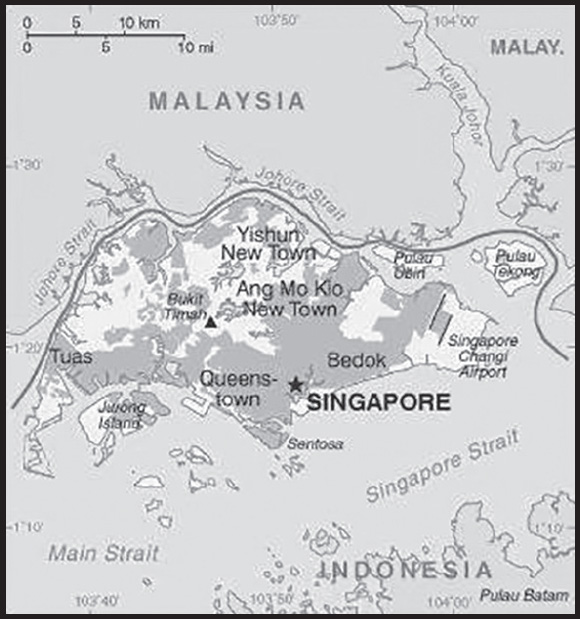
Population distribution: most of the urbanization is along the southern coast, with relatively dense population clusters found in the central areas
Natural hazards: flash floods
Geography - note: focal point for Southeast Asian sea routes; consists of about 60 islands, by far the largest of which is Pulau Ujong; land reclamation has removed many former islands and created a number of new ones
PEOPLE AND SOCIETY
Population: 5,975,383 (2023 est.)
comparison ranking: 113
Nationality: noun: Singaporean(s)
adjective: Singapore
Ethnic groups: Chinese 74.2%, Malay 13.7%, Indian 8.9%, other 3.2% (2021 est.)
note: data represent population by self-identification; the population is divided into four categories: Chinese, Malay (includes indigenous Malays and Indonesians), Indian (includes Indian, Pakistani, Bangladeshi, or Sri Lankan), and other ethnic groups (includes Eurasians, Caucasians, Japanese, Filipino, Vietnamese)
Languages: English (official) 48.3%, Mandarin (official) 29.9%, other Chinese dialects (includes Hokkien, Cantonese, Teochew, Hakka) 8.7%, Malay (official) 9.2%, Tamil (official) 2.5%, other 1.4%; note - data represent language most frequently spoken at home (2020 est.)
major-language sample(s):

Religions: Buddhist 31.1%, Christian 18.9%, Muslim 15.6%, Taoist 8.8%, Hindu 5%, other 0.6%, none 20% (2020 est.)
Demographic profile: Singapore has one of the lowest total fertility rates (TFR) in the world – an average of 1.15 children born per woman – and a rapidly aging population. Women’s expanded educations, widened aspirations, and a desire to establish careers has contributed to delayed marriage and smaller families. Most married couples have only one or two children in order to invest more in each child, including the high costs of education. In addition, more and more Singaporeans, particularly women, are staying single. Factors contributing to this trend are a focus on careers, long working hours, the high cost of living, and long waits for public housing. With fertility at such a low rate and rising life expectancy, the proportion of the population aged 65 or over is growing and the youth population is shrinking. Singapore is projected to experience one of the largest percentage point increases in the elderly share of the population at 21% between 2019 and 2050, according to the UN. The working-age population (aged 15-64) will gradually decrease, leaving fewer workers to economically support the elderly population.
Migration has played a key role in Singapore’s development. As Singapore’s economy expanded during the 19th century, more and more Chinese, Indian, and Malay labor immigrants arrived. Most of Singapore’s pre-World War II population growth was a result of immigration. During World War II, immigration came to a halt when the Japanese occupied the island but revived in the postwar years. Policy was restrictive during the 1950s and 1960s, aiming to protect jobs for residents by reducing the intake of low-skilled foreign workers and focusing instead on attracting professionals from abroad with specialist skills. Consequently, the nonresident share of Singapore’s population plummeted to less than 3%.
As the country industrialized, however, it loosened restrictions on the immigration of manual workers. From the 1980s through the 2000s, the foreign population continued to grow as a result of policies aimed at attracting foreign workers of all skill levels. More recently, the government has instituted immigration policies that target highly skilled workers. Skilled workers are encouraged to stay and are given the opportunity to become permanent residents or citizens. The country, however, imposes restrictions on unskilled and low-skilled workers to ensure they do not establish roots, including prohibiting them from bringing their families and requiring employers to pay a monthly foreign worker levy and security bond. The country has also become increasingly attractive to international students. The growth of the foreign-born population has continued to be rapid; as of 2015, the foreign-born composed 46% of the total population. At the same time, growing numbers of Singaporeans are emigrating for education and work experience in highly skilled sectors such finance, information technology, and medicine. Increasingly, the moves abroad are permanent.
Age structure: 0-14 years: 14.82% (male 458,019/female 427,364)
15-64 years: 71.49% (male 2,148,471/female 2,123,102)
65 years and over: 13.7% (2023 est.) (male 379,373/female 439,054)
Dependency ratios: total dependency ratio: 35.4
youth dependency ratio: 16.2
elderly dependency ratio: 19.1
potential support ratio: 5.2 (2021 est.)
Median age: total: 38.9 years (2023 est.)
male: 37.7 years
female: 40.1 years
comparison ranking: total 67
Population growth rate: 0.9% (2023 est.)
comparison ranking: 105
Birth rate: 8.9 births/1,000 population (2023 est.)
comparison ranking: 203
Death rate: 4.2 deaths/1,000 population (2023 est.)
comparison ranking: 212
Net migration rate: 4.2 migrant(s)/1,000 population (2023 est.)
comparison ranking: 29
Population distribution: most of the urbanization is along the southern coast, with relatively dense population clusters found in the central areas
Urbanization: urban population: 100% of total population (2023)
rate of urbanization: 0.74% annual rate of change (2020-25 est.)
Major urban areas - population: 6.081 million SINGAPORE (capital) (2023)
Sex ratio: at birth: 1.05 male(s)/female
0-14 years: 1.07 male(s)/female
15-64 years: 1.01 male(s)/female
65 years and over: 0.86 male(s)/female
total population: 1 male(s)/female (2023 est.)
Mother’s mean age at first birth: 30.5 years (2015 est.)
note: data represents median age
Maternal mortality ratio: 7 deaths/100,000 live births (2020 est.)
comparison ranking: 157
Infant mortality rate: total: 1.5 deaths/1,000 live births (2023 est.)
male: 1.7 deaths/1,000 live births
female: 1.4 deaths/1,000 live births
comparison ranking: total 226
Life expectancy at birth: total population: 86.5 years (2023 est.)
male: 83.8 years
female: 89.3 years
comparison ranking: total population 2
Total fertility rate: 1.17 children born/woman (2023 est.)
comparison ranking: 225
Gross reproduction rate: 0.57 (2023 est.)
Drinking water source: improved:
total: 100% of population
unimproved: total: 0% of population (2020 est.)
Current health expenditure: 6.1% of GDP (2020)
Physicians density: 2.46 physicians/1,000 population (2019)
Hospital bed density: 2.5 beds/1,000 population (2017)
Sanitation facility access: improved:
total: 100% of population
unimproved: total: 0% of population (2020 est.)
Obesity - adult prevalence rate: 6.1% (2016)
comparison ranking: 170
Alcohol consumption per capita: total: 1.81 liters of pure alcohol (2019 est.)
beer: 1.26 liters of pure alcohol (2019 est.)
wine: 0.27 liters of pure alcohol (2019 est.)
spirits: 0.24 liters of pure alcohol (2019 est.)
other alcohols: 0.04 liters of pure alcohol (2019 est.)
comparison ranking: total 132
Tobacco use: total: 16.5% (2020 est.)
male: 28% (2020 est.)
female: 5% (2020 est.)
comparison ranking: total 99
Currently married women (ages 15-49): 54.3% (2023 est.)
Child marriage: women married by age 18: 0.1% (2022 est.)
Education expenditures: 2.8% of GDP (2021 est.)
comparison ranking: 165
Literacy: definition: age 15 and over can read and write
total population: 97.5%
male: 98.9%
female: 96.1% (2019)
School life expectancy (primary to tertiary education): total: 17 years
male: 16 years
female: 17 years (2020)
Youth unemployment rate (ages 15-24): total: 9.1% (2021 est.)
male: 7%
female: 11.8%
comparison ranking: total 164
ENVIRONMENT
Environment - current issues: water pollution; industrial pollution; limited natural freshwater resources; limited land availability presents waste disposal problems; air pollution; deforestation; seasonal smoke/haze resulting from forest fires in Indonesia
Environment - international agreements: party to: Biodiversity, Climate Change, Climate Change-Kyoto Protocol, Climate Change-Paris Agreement, Comprehensive Nuclear Test Ban, Desertification, Endangered Species, Hazardous Wastes, Law of the Sea, Nuclear Test Ban, Ozone Layer Protection, Ship Pollution
signed, but not ratified: none of the selected agreements
Climate: tropical; hot, humid, rainy; two distinct monsoon seasons - northeastern monsoon (December to March) and southwestern monsoon (June to September); inter-monsoon - frequent afternoon and early evening thunderstorms
Land use: agricultural land: 1% (2018 est.)
arable land: 0.9% (2018 est.)
permanent crops: 0.1% (2018 est.)
permanent pasture: 0% (2018 est.)
forest: 3.3% (2018 est.)
other: 95.7% (2018 est.)
Urbanization: urban population: 100% of total population (2023)
rate of urbanization: 0.74% annual rate of change (2020-25 est.)
Revenue from forest resources: 0% of GDP (2018 est.)
comparison ranking: 190
Revenue from coal: 0% of GDP (2018 est.)
comparison ranking: 131
Air pollutants: particulate matter emissions: 13.33 micrograms per cubic meter (2019 est.)
carbon dioxide emissions: 37.54 megatons (2016 est.)
methane emissions: 4.4 megatons (2020 est.)
Waste and recycling: municipal solid waste generated annually: 7,704,300 tons (2017 est.)
municipal solid waste recycled annually: 4,699,623 tons (2015 est.)
percent of municipal solid waste recycled: 61% (2015 est.)
Total water withdrawal: municipal: 300 million cubic meters (2020 est.)
industrial: 340 million cubic meters (2020 est.)
agricultural: 30 million cubic meters (2020 est.)
Total renewable water resources: 600 million cubic meters (2020 est.)
GOVERNMENT
Country name: conventional long form: Republic of Singapore
conventional short form: Singapore
local long form: Republic of Singapore
local short form: Singapore
etymology: name derives from the Sanskrit words “simha” (lion) and “pura” (city) to describe the city-state’s leonine symbol
Government type: parliamentary republic
Capital: name: Singapore
geographic coordinates: 1 17 N, 103 51 E
time difference: UTC+8 (13 hours ahead of Washington, DC, during Standard Time)
etymology: name derives from the Sanskrit words simha (lion) and pura (city), thus creating the city’s epithet “lion city”
Administrative divisions: no first order administrative divisions; there are five community development councils: Central Singapore Development Council, North East Development Council, North West Development Council, South East Development Council, South West Development Council (2019)
Independence: 9 August 1965 (from Malaysian Federation)
National holiday: National Day, 9 August (1965)
Constitution: history: several previous; latest adopted 22 December 1965
amendments: proposed by Parliament; passage requires two-thirds majority vote in the second and third readings by the elected Parliament membership and assent of the president of the republic; passage of amendments affecting sovereignty or control of the Police Force or the Armed Forces requires at least two-thirds majority vote in a referendum; amended many times, last in 2020
Legal system: English common law
International law organization participation: has not submitted an ICJ jurisdiction declaration; non-party state to the ICCt
Citizenship: citizenship by birth: no
citizenship by descent only: at least one parent must be a citizen of Singapore
dual citizenship recognized: no
residency requirement for naturalization: 10 years
Suffrage: 21 years of age; universal and compulsory
Executive branch: chief of state: President THARMAN Shanmugaratnam (since 14 September 2023)
head of government: Prime Minister LEE Hsien Loong (since 12 August 2004)
cabinet: Cabinet appointed by the president on the advice of the prime minister; Cabinet responsible to Parliament
elections/appointments: president directly elected by simple majority popular vote for a 6-year term (no term limits); election last held on 1 September 2023; next to be held in 2029); following legislative elections, the leader of the majority party or majority coalition appointed prime minister by the president; deputy prime ministers appointed by the president
election results: 2023: THARMAN Shanmugaratnam elected president; percent of vote - THARMAN (independent) 70.4%, Ng Kok Song (independent) 15.7%, Tan Kin Lian (independent) 13.9%; turnout is 93.4%
2017: HALIMAH Yacob declared president on 13 September 2017, being the only eligible candidate
2011: Tony TAN Keng Yam elected president; percent of vote - Tony TAN Keng Yam (independent) 35.2%, TAN Cheng Bock (independent) 34.9%, TAN Jee Say (independent) 25%, TAN Kin Lian (independent) 4.9%
Legislative branch: description: unicameral Parliament (104 seats statutory, 103 current term; 93 members directly elected by simple majority popular vote, up to 9 nominated by a parliamentary selection committee and appointed by the president, and up to 12 non-constituency members from opposition parties to ensure political diversity; members serve 5-year terms); note - the number of nominated members increased to 12 for the 2020 election for the first time
elections: last held on 10 July 2020 (next must be held by 24 November 2025)
election results: percent of vote by party - PAP 89.2%, WP 10.6%, other 0.2%; seats by party - PAP 83, WP 10; composition of total Parliament - men 73, women 30, percent of women 29.1%
Judicial branch: highest court(s): Supreme Court (although the number of judges varies - as of April 2019, the court totaled 20 judges, 7 judicial commissioners, 4 judges of appeal, and 16 international judges); the court is organized into an upper tier Appeal Court and a lower tier High Court
judge selection and term of office: judges appointed by the president from candidates recommended by the prime minister after consultation with the chief justice; judges usually serve until retirement at age 65, but terms can be extended
subordinate courts: district, magistrates’, juvenile, family, community, and coroners’ courts; small claims tribunals; employment claims tribunals
Political parties and leaders: Democratic Progressive Party or DPP [Mohamad Hamim BIN ALIYA]
National Solidarity Party or NSP [Spencer NG]
People’s Action Party or PAP [LEE Hsien Loong]
People’s Power Party or PPP [Goh Meng SENG]
People’s Voice or PV [Lim TEAN]
Progress Singapore Party or PSP [Francis YUEN]
Red Dot United or RDU [Ravi PHILEMON]
Reform Party or RP [Kenneth JEYARETNAM]
Singapore Democratic Alliance or SDA [Desmond LIM]
Singapore Democratic Party or SDP [Dr. CHEE Soon Juan]
Singapore People’s Party or SPP [Steve CHIA]
Singapore United Party or SUP [Andy ZHU]
Workers’ Party or WP [Pritam SINGH]
note: the PAP has won every general election since the end of the British colonial era in 1959
International organization participation: ADB, AOSIS, APEC, Arctic Council (observer), ARF, ASEAN, BIS, C, CP, EAS, FAO, FATF, G-77, IAEA, IBRD, ICAO, ICC (national committees), ICCt, ICRM, IDA, IFC, IFRCS, IHO, ILO, IMF, IMO, IMSO, Interpol, IOC, IPU, ISO, ITSO, ITU, ITUC (NGOs), MIGA, NAM, OPCW, Pacific Alliance (observer), PCA, UN, UNCTAD, UNESCO, UNHCR, UPU, WCO, WHO, WIPO, WMO, WTO
Diplomatic representation in the US: chief of mission: Ambassador LUI Tuck Yew (since 30 June 2023)
chancery: 3501 International Place NW, Washington, DC 20008
telephone: [1] (202) 537-3100
FAX: [1] (202) 537-7086
email address and website:
https://www.mfa.gov.sg/washington/
consulate(s) general: San Francisco
consulate(s): New York
Diplomatic representation from the US: chief of mission: Ambassador Jonathan KAPLAN (since December 2021)
embassy: 27 Napier Road, Singapore 258508
mailing address: 4280 Singapore Place, Washington DC 20521-4280
telephone: [65] 6476-9100
FAX: [65] 6476-9340
email address and website:
Flag description: two equal horizontal bands of red (top) and white; near the hoist side of the red band, there is a vertical, white crescent (closed portion is toward the hoist side) partially enclosing five white five-pointed stars arranged in a circle; red denotes brotherhood and equality; white signifies purity and virtue; the waxing crescent moon symbolizes a young nation on the ascendancy; the five stars represent the nation’s ideals of democracy, peace, progress, justice, and equality
National symbol(s): lion, merlion (mythical half lion-half fish creature), orchid; national colors: red, white
National anthem: name: “Majulah Singapura” (Onward Singapore)
lyrics/music: ZUBIR Said
note: adopted 1965; first performed in 1958 at the Victoria Theatre, the anthem is sung only in Malay
National heritage: total World Heritage Sites: 1 (cultural)
selected World Heritage Site locales: Singapore Botanic Gardens
ECONOMY
Economic overview: high-income, service-based Southeast Asian economy; renowned for financial markets and Asian Infrastructure Exchange; business-driven regulations; low unemployment; electronics, oil, and chemicals exporter; continuing education investment
Real GDP (purchasing power parity): $578.254 billion (2021 est.)
$537.341 billion (2020 est.)
$560.566 billion (2019 est.)
note: data are in 2017 dollars
comparison ranking: 38
Real GDP growth rate: 7.61% (2021 est.)
-4.14% (2020 est.)
1.1% (2019 est.)
comparison ranking: 46
Real GDP per capita: $106,000 (2021 est.)
$94,500 (2020 est.)
$98,300 (2019 est.)
note: data are in 2017 dollars
comparison ranking: 4
GDP (official exchange rate): $372.088 billion (2019 est.)
Inflation rate (consumer prices): 2.3% (2021 est.)
-0.18% (2020 est.)
0.57% (2019 est.)
comparison ranking: 146
Credit ratings:
Fitch rating: AAA (2003)
Moody’s rating: Aaa (2002)
Standard & Poors rating: AAA (1995)
note: The year refers to the year in which the current credit rating was first obtained.
GDP - composition, by sector of origin: agriculture: 0% (2017 est.)
industry: 24.8% (2017 est.)
services: 75.2% (2017 est.)
comparison rankings: services 46; industry 111; agriculture 224
GDP - composition, by end use: household consumption: 35.6% (2017 est.)
government consumption: 10.9% (2017 est.)
investment in fixed capital: 24.8% (2017 est.)
investment in inventories: 2.8% (2017 est.)
exports of goods and services: 173.3% (2017 est.)
imports of goods and services: -149.1% (2017 est.)
Agricultural products: poultry, eggs, vegetables, pork, duck meat, spinach, pig offals, bird eggs, pig fat, cabbages
Industries: electronics, chemicals, financial services, oil drilling equipment, petroleum refining, biomedical products, scientific instruments, telecommunication equipment, processed food and beverages, ship repair, offshore platform construction, entrepot trade
Industrial production growth rate: 13.32% (2021 est.)
comparison ranking: 20
Labor force: 3.29 million (2021 est.)
note: excludes non-residents
comparison ranking: 101
Labor force - by occupation: agriculture: 0.7%
industry: 25.6%
services: 73.7% (2017)
note: excludes non-residents
Unemployment rate: 3.62% (2021 est.)
4.1% (2020 est.)
3.1% (2019 est.)
comparison ranking: 185
Youth unemployment rate (ages 15-24): total: 9.1% (2021 est.)
male: 7%
female: 11.8%
comparison ranking: total 164
Gini Index coefficient - distribution of family income: 45.9 (2017)
comparison ranking: 23
Average household expenditures: on food: 6.9% of household expenditures (2018 est.)
on alcohol and tobacco: 1.9% of household expenditures (2018 est.)
Household income or consumption by percentage share: lowest 10%: 1.6%
highest 10%: 27.5% (2017)
Budget: revenues: $59.974 billion (2020 est.)
expenditures: $90.264 billion (2020 est.)
note: expenditures include both operational and development expenditures
Budget surplus (+) or deficit (-): -0.3% (of GDP) (2017 est.)
comparison ranking: 52
Public debt: 153.41% of GDP (2020 est.)
128.31% of GDP (2019 est.)
110.73% of GDP (2018 est.)
note: Singapore’s public debt consists largely of Singapore Government Securities (SGS) issued to assist the Central Provident Fund (CPF), which administers Singapore’s defined contribution pension fund; special issues of SGS are held by the CPF, and are non-tradable; the government has not borrowed to finance deficit expenditures since the 1980s; Singapore has no external public debt
comparison ranking: 4
Taxes and other revenues: 12.89% (of GDP) (2020 est.)
comparison ranking: 171
Fiscal year: 1 April - 31 March
Current account balance: $71.926 billion (2021 est.)
$58.139 billion (2020 est.)
$54.273 billion (2019 est.)
comparison ranking: 8
Exports: $733.782 billion (2021 est.) note: data are in current year dollars
$627.442 billion (2020 est.) note: data are in current year dollars
$658.127 billion (2019 est.) note: data are in current year dollars
comparison ranking: 10
Exports - partners: China 16%, Hong Kong 16%, United States 8%, Malaysia 9%, Indonesia 5% (2021)
Exports - commodities: integrated circuits, refined petroleum, gold, packaged medicines, appliances, photo lab equipment (2021)
Imports: $609.28 billion (2021 est.) note: data are in current year dollars
$517.967 billion (2020 est.) note: data are in current year dollars
$550.209 billion (2019 est.) note: data are in current year dollars
comparison ranking: 12
Imports - partners: China 16%, Malaysia 11%, United States 9%, Taiwan 7%, Japan 5%, Indonesia 5% (2019)
Imports - commodities: integrated circuits, refined petroleum, crude petroleum, gold, gas turbines (2019)
Reserves of foreign exchange and gold: $425.098 billion (31 December 2021 est.)
$369.834 billion (31 December 2020 est.)
$285.478 billion (31 December 2019 est.)
comparison ranking: 11
Debt - external: $1,557,646,000,000 (2019 est.)
$1,528,177,000,000 (2018 est.)
comparison ranking: 16
Exchange rates: Singapore dollars (SGD) per US dollar -
Exchange rates:
1.343 (2021 est.)
1.38 (2020 est.)
1.364 (2019 est.)
1.349 (2018 est.)
1.381 (2017 est.)
ENERGY
Electricity access: electrification - total population: 100% (2021)
Electricity: installed generating capacity: 12.24 million kW (2020 est.)
consumption: 50,742,380,000 kWh (2019 est.)
exports: 0 kWh (2019 est.)
imports: 0 kWh (2020 est.)
transmission/distribution losses: 571 million kWh (2019 est.)
comparison rankings: imports 154; installed generating capacity 57; transmission/distribution losses 127; exports 142; consumption 49
Electricity generation sources: fossil fuels: 96.5% of total installed capacity (2020 est.)
solar: 1.2% of total installed capacity (2020 est.)
biomass and waste: 2.3% of total installed capacity (2020 est.)
Coal: production: 0 metric tons (2020 est.)
consumption: 423,000 metric tons (2020 est.)
exports: 1,000 metric tons (2020 est.)
imports: 424,000 metric tons (2020 est.)
proven reserves: 0 metric tons (2019 est.)
Petroleum: total petroleum production: 0 bbl/day (2021 est.)
refined petroleum consumption: 1.448 million bbl/day (2019 est.)
crude oil and lease condensate exports: 13,000 bbl/day (2018 est.)
crude oil and lease condensate imports: 1,121,200 bbl/day (2018 est.)
crude oil estimated reserves: 0 barrels (2021 est.)
Refined petroleum products - production: 755,000 bbl/day (2015 est.)
comparison ranking: 24
Refined petroleum products - exports: 1.82 million bbl/day (2015 est.)
comparison ranking: 4
Refined petroleum products - imports: 2.335 million bbl/day (2015 est.)
comparison ranking: 1
Natural gas: production: 0 cubic meters (2021 est.)
consumption: 13,396,282,000 cubic meters (2019 est.)
exports: 550.818 million cubic meters (2020 est.)
imports: 14,727,709,000 cubic meters (2020 est.)
proven reserves: 0 cubic meters (2021 est.)
Carbon dioxide emissions: 238.983 million metric tonnes of CO2 (2019 est.)
from coal and metallurgical coke: 1.588 million metric tonnes of CO2 (2019 est.)
from petroleum and other liquids: 211.115 million metric tonnes of CO2 (2019 est.)
from consumed natural gas: 26.28 million metric tonnes of CO2 (2019 est.)
comparison ranking: total emissions 28
Energy consumption per capita: 639.951 million Btu/person (2019 est.)
comparison ranking: 2
COMMUNICATIONS
Telephones - fixed lines: total subscriptions: 1,887,500 (2021 est.)
subscriptions per 100 inhabitants: 32 (2021 est.)
comparison ranking: total subscriptions 55
Telephones - mobile cellular: total subscriptions: 8,660,700 (2021 est.)
subscriptions per 100 inhabitants: 146 (2021 est.)
comparison ranking: total subscriptions 96
Telecommunication systems: general assessment: a wealthy city-state, Singapore has a highly developed ICT infrastructure; government supported near universal home broadband penetration and free public access to wireless network; the government’s telecommunication regulator, Infocomm Media Development Authority (IMDA), issued awards in mid-2020 to telecom operators with the goal of having at least 50% of the city-state covered with a standalone 5G network by the end of 2022; government actively promoting Smart Nation initiative supporting digital innovation; government oversees service providers and controls Internet content; well served by submarine cable and satellite connections (2021)
domestic: fixed-line is 32 per 100 and mobile-cellular 146 per 100 teledensity (2021)
international: country code - 65; landing points for INDIGO-West, SeaMeWe -3,-4,-5, SIGMAR, SJC, i2icn, PGASCOM, BSCS, IGG, B3JS, SAEx2, APCN-2, APG, ASC, SEAX-1, ASE, EAC-C2C, Matrix Cable System and SJC2 submarine cables providing links throughout Asia, Southeast Asia, Africa, Australia, the Middle East, and Europe; satellite earth stations - 3, Bukit Timah, Seletar, and Sentosa; supplemented by VSAT coverage (2019)
Broadcast media: state controls broadcast media; 6 domestic TV stations operated by MediaCorp which is wholly owned by a state investment company; broadcasts from Malaysian and Indonesian stations available; satellite dishes banned; multichannel cable TV services available; a total of 19 domestic radio stations broadcasting, with MediaCorp operating 11, Singapore Press Holdings, also government-linked, another 5, 2 controlled by the Singapore Armed Forces Reservists Association and one owned by BBC Radio; Malaysian and Indonesian radio stations are available as is BBC; a number of Internet service radio stations are also available (2019)
Internet country code: .sg
Internet users: total: 5.369 million (2021 est.)
percent of population: 91% (2021 est.)
comparison ranking: total 88
Broadband - fixed subscriptions: total: 1,509,700 (2020 est.)
subscriptions per 100 inhabitants: 26 (2020 est.)
comparison ranking: total 66
TRANSPORTATION
National air transport system: number of registered air carriers: 4 (2020)
inventory of registered aircraft operated by air carriers: 230
annual passenger traffic on registered air carriers: 40,401,515 (2018)
annual freight traffic on registered air carriers: 5,194,900,000 (2018) mt-km
Civil aircraft registration country code prefix: 9V
Airports: 9 (2021)
comparison ranking: total 158
Airports - with paved runways: 9
civil airports: 0
military airports: 2
joint use (civil-military) airports: 3
other airports: 4
note: paved runways have a concrete or asphalt surface but not all have facilities for refueling, maintenance, or air traffic control; the length of a runway required for aircraft to safely operate depends on a number of factors including the type of aircraft, the takeoff weight (including passengers, cargo, and fuel), engine types, flap settings, landing speed, elevation of the airport, and average maximum daily air temperature; paved runways can reach a length of 5,000 m (16,000 ft.), but the “typical” length of a commercial airline runway is between 2,500-4,000 m (8,000-13,000 ft.)
Pipelines: 3,220 km domestic gas (2014), 1,122 km cross-border pipelines (2017), 8 km refined products (2013) (2013)
Roadways: total: 3,500 km (2017)
paved: 3,500 km (2017) (includes 164 km of expressways)
comparison ranking: total 158
Merchant marine: total: 3,227 (2022)
by type: bulk carrier 574, container ship 542, general cargo 99, oil tanker 633, other 1,379
comparison ranking: total 7
Ports and terminals: major seaport(s): Singapore
container port(s) (TEUs): Singapore (37,470,000) (2021)
LNG terminal(s) (import): Singapore
MILITARY AND SECURITY
Military and security forces: Singapore Armed Forces (SAF; aka Singapore Defense Force): Singapore Army, Republic of Singapore Navy, Republic of Singapore Air Force (includes air defense), Digital and Intelligence Service
Ministry of Home Affairs: Singapore Police Force (includes Police Coast Guard and the Gurkha Contingent) (2023)
note 1: the Digital and Intelligence Service (DIS) was stood up as the fourth SAF service in October of 2022
note 2: the Gurkha Contingent of the Singapore Police Force (GCSPF) is a paramilitary unit for riot control and acts as a rapid reaction force
note 3: in 2009, Singapore established a multi-agency national Maritime Security Task Force (MSTF) to work with law enforcement and maritime agencies to guard Singapore’s waters, including conducting daily patrols, as well as boarding and escort operations in the Singapore Strait; the MSTF is subordinate to the Singapore Navy
Military expenditures: 3% of GDP (2022 est.)
3% of GDP (2021 est.)
3% of GDP (2020)
2.9% of GDP (2019)
2.9% of GDP (2018)
comparison ranking: 29
Military and security service personnel strengths: information varies; approximately 60,000 active-duty troops (45,000 Army; 7,000 Navy; 8,000 Air Force) (2023)
Military equipment inventories and acquisitions: the SAF has a diverse and largely modern mix of domestically produced and imported Western weapons systems; in recent years, France and the US have been the chief suppliers of arms; Singapore has the most developed arms industry in Southeast Asia and is also its largest importer of weapons (2023)
Military service age and obligation: 18-21 years of age for compulsory military service for men; 16.5 years of age for voluntary enlistment (with parental consent); 24-month conscript service obligation, with a reserve obligation to age 40 (enlisted) or age 50 (officers); women are not conscripted, but they are allowed to volunteer for all services and branches, including combat arms (2023)
note 1: under the Enlistment Act, all male Singaporean citizens and permanent residents, unless exempted, are required to enter National Service (NS) upon attaining the age of 18; most NS conscripts serve in the Armed Forces, but some go into the Police Force or Civil Defense Force; conscripts comprise over half of the defense establishment
note 2: as of 2019, women made up about 8% of the active force
note 3: the Singapore Armed Forces (SAF) also has a uniformed volunteer auxiliary branch known as the Volunteer Corps (SAFVC); the SAFVC allows citizens and residents not subject to the National Service obligation, including Singaporean women, first generation permanent residents, and naturalized citizens, to contribute towards Singapore’s defense; the volunteers must be 18-45 and physically fit
note 4: members of the Gurkha Contingent (GC) of the Singapore Police Force are mostly recruited from a small number of hill tribes in Nepal; the GC was formed in 1949 originally from selected ex-British Army Gurkhas
Military deployments: maintains permanent training detachments of military personnel in Australia, France, and the US (2023)
Military - note: the SAF’s roots go back to 1854 when the Singapore Volunteer Rifle Corps was formed under colonial rule; the first battalion of regular soldiers, the First Singapore Infantry Regiment, was organized in 1957; the modern SAF was established in 1965 and is today widely viewed as the best equipped military in Southeast Asia; the SAF’s primary responsibility is external defense, but it has trained for certain domestic security operations, including joint deterrence patrols with police in instances of heightened terrorism alerts; the Army is organized into 3 combined arms divisions and a “people’s defense force,” a divisional headquarters responsible for homeland security and counterterrorism; the Army is based largely on 2-year conscripts and reservists with a small cadre of professional soldiers, and Army units are comprised of a mix of active duty and cadre/reserve battalions that are filled out by reservists upon mobilization; the Air Force and Navy are primarily comprised of professionals; the Air Force has over 100 modern US-origin combat aircraft, plus squadrons for anti-submarine warfare, maritime patrol, early warning, surveillance, and logistical support, as well as unmanned aerial vehicles and attack helicopters; the Navy’s principal combat vessels are a mix of about 20 frigates, corvettes, and littoral combat ships (comparable to a corvette in capabilities), plus a few submarines
Singapore is a member of the Five Powers Defense Arrangements (FPDA), a series of mutual assistance agreements reached in 1971 embracing Australia, Malaysia, New Zealand, Singapore, and the UK; the FPDA commits the members to consult with one another in the event or threat of an armed attack on any of the members and to mutually decide what measures should be taken, jointly or separately; there is no specific obligation to intervene militarily (2023)
SPACE
Space agency/agencies: no national government agency; Office for Space Technology and Industry (OSTin) was established in 2013 as a nongovernment space economic development program with the role of coordinating local space-related industry, universities, international businesses, and government agencies to encourage the development of space technologies in the private sector; the Center for Remote Sensing and Processing (CRISP) is under the National University of Singapore and established with funding from the Agency for Science, Technology, and Research of Singapore; CRISP’s mission is to develop an advanced capability in remote sensing (RS) to meet the scientific, operational, and business requirements of Singapore and the region (2023)
Space program overview: space program and capabilities are largely commercial with a focus on acquiring or developing and manufacturing small RS (including optical and microwave) satellites, other satellite-related capabilities, such as data processing, and rockets capable of placing small satellites in low Earth orbit; manufactures and operates satellites; has a considerable civil/commercial and university-based research and development program; has established relations with the space agencies and industries of China, the European Space Agency, India, Japan, and the US; has over 50 companies involved in space-related technology development and manufacturing (2023)
note: further details about the key activities, programs, and milestones of the country’s space program, as well as government spending estimates on the space sector, appear in Appendix S
TRANSNATIONAL ISSUES
Disputes - international: piracy remains a problem in the Malacca Strait
Singapore-Indonesia: Indonesia and Singapore continue to work on finalization of their 1973 maritime boundary agreement by defining unresolved areas north of Indonesia’s Batam Island; subsequent treaties were signed in 2009 (ratified in 2010) and 2014 (ratified in 2017) settling the two countries’ boundaries in the Singapore Strait
Singapore-Malaysia: disputes with Malaysia over territorial waters, airspace, the price of fresh water delivered to Singapore from Malaysia, Singapore’s extensive land reclamation works, bridge construction, and maritime boundaries in the Johor and Singapore Straits; in 2008, the International Court of Justice awarded sovereignty of Pedra Branca (Pulau Batu Puteh/Horsburgh Island) to Singapore, and Middle Rocks to Malaysia, but did not rule on maritime regimes, boundaries, or disposition of South Ledge, which is only visible at low tide
https://en.wikipedia.org/wiki/Indonesia%E2%80%93Singapore_border
https://en.wikipedia.org/wiki/Pedra_Branca_dispute
https://thediplomat.com/2021/09/the-1962-johor-singapore-water-agreement-lessons-learned/
Refugees and internally displaced persons: stateless persons: 1,109 (2022)
Illicit drugs: drug abuse limited because of aggressive law enforcement efforts, including carrying out death sentences; as a transportation and financial services hub, Singapore is vulnerable, despite strict laws and enforcement, as a venue for money laundering
SINT MAARTEN
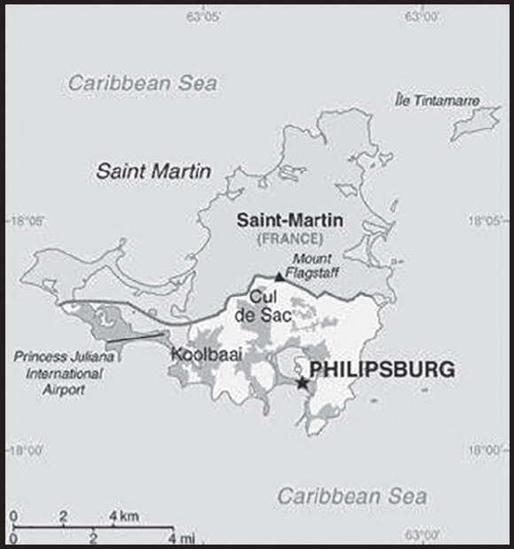
INTRODUCTION
Background: Although sighted by Christopher COLUMBUS in 1493 and claimed for Spain, it was the Dutch who occupied the island in 1631 and began exploiting its salt deposits. The Spanish retook the island in 1633, but the Dutch continued to assert their claims. The Spanish finally relinquished the island of Saint Martin to the French and Dutch, who divided it between themselves in 1648. The establishment of cotton, tobacco, and sugar plantations dramatically expanded African slavery on the island in the 18th and 19th centuries; the practice was not abolished in the Dutch half until 1863. The island’s economy declined until 1939 when it became a free port; the tourism industry was dramatically expanded beginning in the 1950s. In 1954, Sint Maarten and several other Dutch Caribbean possessions became part of the Kingdom of the Netherlands as the Netherlands Antilles. In a 2000 referendum, the citizens of Sint Maarten voted to become a self-governing country within the Kingdom of the Netherlands, effective October 2010. On 6 September 2017, Hurricane Irma hit Saint Martin/Sint Maarten, causing extensive damage to roads, communications, electrical power, and housing. The UN estimated the storm destroyed or damaged 90% of the buildings, and Princess Juliana International Airport was heavily damaged and closed to commercial air traffic for five weeks.
GEOGRAPHY
Location: Caribbean, located in the Leeward Islands (northern) group; Dutch part of the island of Saint Martin in the Caribbean Sea; Sint Maarten lies east of the US Virgin Islands
Geographic coordinates: 18 4 N, 63 4 W
Map references: Central America and the Caribbean
Area: total: 34 sq km
land: 34 sq km
water: 0 sq km
note: Dutch part of the island of Saint Martin
comparison ranking: total 235
Area - comparative: one-fifth the size of Washington, DC
Land boundaries: total: 16 km
border countries (1): Saint Martin (France) 16 km
Coastline: 58.9 km (for entire island)
Maritime claims: territorial sea: 12 nm
exclusive economic zone: 200 nm
Climate: tropical marine climate, ameliorated by northeast trade winds, results in moderate temperatures; average rainfall of 150 cm/year; hurricane season stretches from July to November
Terrain: low, hilly terrain, volcanic origin
Elevation: highest point: Mount Flagstaff 383 m
lowest point: Caribbean Sea 0 m
Natural resources: fish, salt
Population distribution: most populous areas are Lower Prince’s Quarter (north of Philipsburg), followed closely by Cul de Sac
Natural hazards: subject to hurricanes from July to November
Geography - note: note 1: the northern border is shared with the French overseas collectivity of Saint Martin; together, these two entities make up the smallest landmass in the world shared by two self-governing states
note 2: Simpson Bay Lagoon (aka as Simson Bay Lagoon or The Great Pond) is one of the largest inland lagoons in the West Indies; the border between the French and Dutch halves of the island of Saint Martin runs across the center of the lagoon, which is shared by both of the island’s entities
PEOPLE AND SOCIETY
Population: 45,677 (2023 est.)
comparison ranking: 210
Ethnic groups: Saint Maarten 29.9%, Dominican Republic 10.2%, Haiti 7.8%, Jamaica 6.6%, Saint Martin 5.9%, Guyana 5%, Dominica 4.4%, Curacao 4.1%, Aruba 3.4%, Saint Kitts and Nevis 2.8%, India 2.6%, Netherlands 2.2%, US 1.6%, Suriname 1.4%, Saint Lucia 1.3%, Anguilla 1.1%, other 8%, unspecified 1.7% (2011 est.)
note: data represent population by country of birth
Languages: English (official) 67.5%, Spanish 12.9%, Creole 8.2%, Dutch (official) 4.2%, Papiamento (a Spanish-Portuguese-Dutch-English dialect) 2.2%, French 1.5%, other 3.5% (2001 est.)
Religions: Protestant 41.9% (Pentecostal 14.7%, Methodist 10.0%, Seventh Day Adventist 6.6%, Baptist 4.7%, Anglican 3.1%, other Protestant 2.8%), Roman Catholic 33.1%, Hindu 5.2%, Christian 4.1%, Jehovah’s Witness 1.7%, Evangelical 1.4%, Muslim/Jewish 1.1%, other 1.3% (includes Buddhist, Sikh, Rastafarian), none 7.9%, no response 2.4% (2011 est.)
Age structure: 0-14 years: 18.52% (male 4,379/female 4,082)
15-64 years: 67.18% (male 15,157/female 15,530)
65 years and over: 14.29% (2023 est.) (male 3,019/female 3,510)
Dependency ratios: total dependency ratio: 27.2
youth dependency ratio: 14.9
elderly dependency ratio: 12.3
potential support ratio: 8.1 (2021)
Median age: total: 41.1 years (2023 est.)
male: 39.3 years
female: 42.8 years
comparison ranking: total 49
Population growth rate: 1.19% (2023 est.)
comparison ranking: 80
Birth rate: 12.4 births/1,000 population (2023 est.)
comparison ranking: 142
Death rate: 6.2 deaths/1,000 population (2023 est.)
comparison ranking: 147
Net migration rate: 5.8 migrant(s)/1,000 population (2023 est.)
comparison ranking: 21
Population distribution: most populous areas are Lower Prince’s Quarter (north of Philipsburg), followed closely by Cul de Sac
Urbanization: urban population: 100% of total population (2023)
rate of urbanization: 1.16% annual rate of change (2020-25 est. est.)
Major urban areas - population: 1,327 PHILIPSBURG (capital) (2011)
Sex ratio: at birth: 1.05 male(s)/female
0-14 years: 1.07 male(s)/female
15-64 years: 0.98 male(s)/female
65 years and over: 0.86 male(s)/female
total population: 0.98 male(s)/female (2023 est.)
Infant mortality rate: total: 7.8 deaths/1,000 live births (2023 est.)
male: 8.6 deaths/1,000 live births
female: 7 deaths/1,000 live births
comparison ranking: total 149
Life expectancy at birth: total population: 79.5 years (2023 est.)
male: 77.2 years
female: 82 years
comparison ranking: total population 62
Total fertility rate: 1.98 children born/woman (2023 est.)
comparison ranking: 109
Gross reproduction rate: 0.97 (2023 est.)
Drinking water source: improved: total: 95.1% of population
unimproved: total: 4.9% of population (2017)
Sanitation facility access: improved:
total: 98.8% of population
unimproved: total: 1.2% of population (2017)
School life expectancy (primary to tertiary education): total: 12 years
male: 12 years
female: 12 years (2014)
ENVIRONMENT
Environment - current issues: scarcity of potable water (increasing percentage provided by desalination); inadequate solid waste management; pollution from construction, chemical runoff, and sewage harms reefs
Climate: tropical marine climate, ameliorated by northeast trade winds, results in moderate temperatures; average rainfall of 150 cm/year; hurricane season stretches from July to November
Urbanization: urban population: 100% of total population (2023)
rate of urbanization: 1.16% annual rate of change (2020-25 est. est.)
GOVERNMENT
Country name: conventional long form: Country of Sint Maarten
conventional short form: Sint Maarten
local long form: Land Sint Maarten (Dutch)/ Country of Sint Maarten (English)
local short form: Sint Maarten (Dutch and English)
former: Netherlands Antilles; Curacao and Dependencies
etymology: explorer Christopher COLUMBUS named the island after Saint MARTIN of Tours because the 11 November 1493 day of discovery was the saint’s feast day
Government type: parliamentary democracy under a constitutional monarchy
Dependency status: constituent country within the Kingdom of the Netherlands; full autonomy in internal affairs granted in 2010; Dutch Government responsible for defense and foreign affairs
Capital: name: Philipsburg
geographic coordinates: 18 1 N, 63 2 W
time difference: UTC-4 (1 hour ahead of Washington, DC, during Standard Time)
etymology: founded and named in 1763 by John PHILIPS, a Scottish captain in the Dutch navy
Administrative divisions: none (part of the Kingdom of the Netherlands)
note: Sint Maarten is one of four constituent countries of the Kingdom of the Netherlands; the other three are the Netherlands, Aruba, and Curacao
Independence: none (part of the Kingdom of the Netherlands)
National holiday: King’s Day (birthday of King WILLEM-ALEXANDER), 27 April (1967); note - King’s or Queen’s Day are observed on the ruling monarch’s birthday; celebrated on 26 April if 27 April is a Sunday; local holiday Sint Maarten’s Day, 11 November (1985), commemorates the discovery of the island by COLUMBUS on Saint Martin’s Day, 11 November 1493; celebrated on both halves of the island
Constitution: history: previous 1947, 1955; latest adopted 21 July 2010, entered into force 10 October 2010 (regulates governance of Sint Maarten but is subordinate to the Charter for the Kingdom of the Netherlands)
amendments: proposals initiated by the Government or by Parliament; passage requires at least a two-thirds majority of the Parliament membership; passage of amendments relating to fundamental rights, authorities of the governor and of Parliament must include the “views” of the Kingdom of the Netherlands Government prior to ratification by Parliament
Legal system: based on Dutch civil law system with some English common law influence
Citizenship: see the Netherlands
Suffrage: 18 years of age; universal
Executive branch: chief of state: King WILLEM-ALEXANDER of the Netherlands (since 30 April 2013); represented by Governor Ajamu G. BALY (since 10 October 2022)
head of government: Prime Minister Silveria JACOBS (since 28 March 2020)
cabinet: Cabinet nominated by the prime minister and appointed by the governor
elections/appointments: the monarch is hereditary; governor general appointed by the monarch for a 6-year term; following parliamentary elections, the leader of the majority party usually elected prime minister by Parliament
Legislative branch: description: unicameral Parliament of Sint Maarten (15 seats; members directly elected by proportional representation vote to serve 4-year terms)
elections: last held 9 January 2020 (next to be held on 11 January 2024)
election results: percent of vote by party - NA 35.2%, UP 24.2%, US Party 13.2%, PFP 10.6%, UD 8.7%, other 8.1%; seats by party - NA 6, UP 4, PFP 2, US Party 2, UD 1
Judicial branch: highest court(s): Joint Court of Justice of Aruba, Curacao, Sint Maarten, and of Bonaire, Sint Eustatius and Saba or “Joint Court of Justice” (consists of the presiding judge, other members, and their substitutes); final appeals heard by the Supreme Court (in The Hague, Netherlands); note - prior to 2010, the Joint Court of Justice was the Common Court of Justice of the Netherlands Antilles and Aruba
judge selection and term of office: Joint Court judges appointed by the monarch serve for life
subordinate courts: Courts in First Instance
Political parties and leaders: National Alliance or NA [Silveria JACOBS]
Party for Progress or PFP [Melissa GUMBS]
Sint Maarten Christian Party or SMCP [Garcia ARRINDELL]
United Democrats Party or UD [Sarah WESCOT-WILLIAMS]
United People’s Party or UP [Theodore HEYLIGER]
United Sint Maarten Party or US Party [Frans RICHARDSON]
International organization participation: Caricom (observer), ILO, Interpol, UNESCO (associate), UPU, WMO
Diplomatic representation in the US: none (represented by the Kingdom of the Netherlands)
Diplomatic representation from the US: embassy: the US does not have an embassy in Sint Maarten; the Consul General to Curacao is accredited to Sint Maarten
Flag description: two equal horizontal bands of red (top) and blue with a white isosceles triangle based on the hoist side; the center of the triangle displays the Sint Maarten coat of arms; the arms consist of an orange-bordered blue shield prominently displaying the white court house in Philipsburg, as well as a bouquet of yellow sage (the national flower) in the upper left, and the silhouette of a Dutch-French friendship monument in the upper right; the shield is surmounted by a yellow rising sun in front of which is a brown pelican in flight; a yellow scroll below the shield bears the motto: SEMPER PROGREDIENS (Always Progressing); the three main colors are identical to those on the Dutch flag
note: the flag somewhat resembles that of the Philippines but with the main red and blue bands reversed; the banner more closely evokes the wartime Philippine flag
National symbol(s): brown pelican, yellow sage (flower); national colors: red, white, blue
National anthem: name: O Sweet Saint Martin’s Land
lyrics/music: Gerard KEMPS
note: the song, written in 1958, is used as an unofficial anthem for the entire island (both French and Dutch sides); as a collectivity of France, in addition to the local anthem, “La Marseillaise” is official on the French side (see France); as a constituent part of the Kingdom of the Netherlands, in addition to the local anthem, “Het Wilhelmus” is official on the Dutch side (see Netherlands)
ECONOMY
Economic overview: high-income, tourism-based Dutch autonomous constituent economy; severe hurricane- and COVID-19-related economic recessions; multilateral trust fund helping offset economic downturn; no property taxation; re-exporter to Saint Martin
Real GDP (purchasing power parity): $1.44 billion (2018 est.) note: data are in 2017 dollars
$1.436 billion (2018 est.)
$1.538 billion (2017 est.)
comparison ranking: 202
Real GDP growth rate: -6.6% (2018 est.)
-5.8% (2017 est.)
1.9% (2012 est.)
comparison ranking: 214
Real GDP per capita: $35,300 (2018 est.) note: data are in 2017 dollars
$35,342 (2018 est.)
$37,914 (2017 est.)
comparison ranking: 58
GDP (official exchange rate): $304.1 million (2014 est.)
Inflation rate (consumer prices): 2.19% (2017 est.)
0.7% (2009 est.)
comparison ranking: 152
GDP - composition, by sector of origin: agriculture: 0.4% (2008 est.)
industry: 18.3% (2008 est.)
services: 81.3% (2008 est.)
comparison rankings: services 29; industry 161; agriculture 213
Agricultural products: sugar
Industries: tourism, light industry
Labor force: 23,200 (2008 est.)
comparison ranking: 210
Labor force - by occupation: agriculture: 1.1%
industry: 15.2%
services: 83.7% (2008 est.)
Unemployment rate: 12% (2012 est.)
10.6% (2008 est.)
comparison ranking: 55
Current account balance: -$294.32 million (2021 est.)
-$290.458 million (2020 est.)
-$165.039 million (2019 est.)
comparison ranking: 107
Exports: $787.981 million (2021 est.) note: data are in current year dollars
$527.044 million (2020 est.) note: data are in current year dollars
$1.091 billion (2019 est.)
comparison ranking: 183
Exports - commodities: sugar
Imports: $992.658 million (2021 est.) note: data are in current year dollars
$760.824 million (2020 est.) note: data are in current year dollars
$1.237 billion (2019 est.)
comparison ranking: 188
Exchange rates: Netherlands Antillean guilders (ANG) per US dollar -
Exchange rates:
1.79 (2021 est.)
1.79 (2020 est.)
1.79 (2019 est.)
1.79 (2018 est.)
1.79 (2017 est.)
ENERGY
Electricity access: electrification - total population: 100% (2021)
Refined petroleum products - imports: 10,440 bbl/day (2015 est.)
comparison ranking: 148
COMMUNICATIONS
Telephones - mobile cellular: total subscriptions: 68,840 (2012 est.)
subscriptions per 100 inhabitants: 196 (2012 est.)
comparison ranking: total subscriptions 199
Telecommunication systems: general assessment: generally adequate facilities; growth sectors include mobile telephone and data segments; effective competition; LTE expansion; tourism and telecom sector contribute greatly to the GDP (2018)
domestic: 196 per 100 mobile-cellular teledensity (2012)
international: country code - 1-721; landing points for SMPR-1 and the ECFS submarine cables providing connectivity to the Caribbean; satellite earth stations - 2 Intelsat (Atlantic Ocean) (2019)
Internet country code: .sx; note - IANA has designated .sx for Sint Maarten, but has not yet assigned it to a sponsoring organization
Internet users: total: 39,089 (2022)
percent of population: 89.5% (2022)
comparison ranking: total 203
TRANSPORTATION
Airports: 1 (2021)
comparison ranking: total 236
Airports - with paved runways: 1
note: paved runways have a concrete or asphalt surface but not all have facilities for refueling, maintenance, or air traffic control; the length of a runway required for aircraft to safely operate depends on a number of factors including the type of aircraft, the takeoff weight (including passengers, cargo, and fuel), engine types, flap settings, landing speed, elevation of the airport, and average maximum daily air temperature; paved runways can reach a length of 5,000 m (16,000 ft.), but the “typical” length of a commercial airline runway is between 2,500-4,000 m (8,000-13,000 ft.)
Roadways: total: 53 km
comparison ranking: total 216
Ports and terminals: major seaport(s): Philipsburg
oil terminal(s): Coles Bay oil terminal
MILITARY AND SECURITY
Military and security forces: no regular military forces; Police Department for local law enforcement, supported by the Royal Netherlands Marechaussee (Gendarmerie), the Dutch Caribbean Police Force (Korps Politie Caribisch Nederland, KPCN), and the Dutch Caribbean Coast Guard (DCCG or Kustwacht Caribisch Gebied (KWCARIB)) (2023)
Military - note: defense is the responsibility of the Kingdom of the Netherlands
TRANSNATIONAL ISSUES
Disputes - international: non identified
Trafficking in persons: tier rating: Tier 3 — Sint Maarten does not fully meet the minimum standards for the elimination of trafficking and is not making significant efforts to do so, therefore Sint Maarten was downgraded to Tier 3; officials took some steps to address trafficking, including investigating a potential trafficking case; however, the government did not report prosecuting or convicting any traffickers nor identify any victims for the second consecutive year; Sint Maarten was not equipped to provide services to trafficking victims due to its lack of shelters, funding, and formal arrangements with service providers; the government did not update its national action plan, which expired in 2018, and interagency coordination was severely lacking; officials consistently conflated human trafficking with migrant smuggling (2022)
trafficking profile: human traffickers exploit domestic and foreign victims in Sint Maarten; some brothel and dance club owners exploit women and girls from Latin America, the Caribbean, Eastern Europe, and Russia in sex trafficking; women from Haiti, Dominican Republic, and Venezuela are especially vulnerable to sex trafficking in Sint Maarten; government officials report a significant number of migrant workers are vulnerable to coercive schemes in domestic service, construction, Chinese national-owned markets, retail shops, food service, landscaping, and housekeeping; criminals, including smugglers, subject migrants—specifically Cuban and Brazilian nationals—who transit Sint Maarten en route to the United States and Canada to forced labor or sex trafficking; traffickers may exploit, under false pretenses, Colombian and Venezuelan women traveling to the islands in forced labor or sex trafficking (2022)
SLOVAKIA
INTRODUCTION
Background: Slovakia traces its roots to the 9th century state of Great Moravia. Subsequently, the Slovaks became part of the Hungarian Kingdom, where they remained for the next 1,000 years. After the formation of the dual Austro-Hungarian monarchy in 1867, backlash to language and education policies favoring the use of Hungarian (Magyarization) encouraged the strengthening of Slovak nationalism and a cultivation of cultural ties with the closely related Czechs, who fell administratively under the Austrian half of the empire. After the dissolution of the Austro-Hungarian Empire at the close of World War I, the Slovaks joined the Czechs to form Czechoslovakia. The new state was envisioned as a nation with Czech and Slovak branches. During the interwar period, Slovak nationalist leaders pushed for autonomy within Czechoslovakia, and in 1939 Slovakia became an independent state created by and allied with Nazi Germany. Following World War II, Czechoslovakia was reconstituted and came under communist rule within Soviet-dominated Eastern Europe. In 1968, an invasion by Warsaw Pact troops ended the efforts of Czechoslovakia’s leaders to liberalize communist rule and create “socialism with a human face,” ushering in a period of repression known as “normalization.” The peaceful “Velvet Revolution” swept the Communist Party from power at the end of 1989 and inaugurated a return to democratic rule and a market economy. On 1 January 1993, Czechoslovakia underwent a nonviolent “velvet divorce” into its two national components, Slovakia and the Czech Republic. Slovakia joined both NATO and the EU in the spring of 2004 and the euro zone on 1 January 2009.
GEOGRAPHY
Location: Central Europe, south of Poland
Geographic coordinates: 48 40 N, 19 30 E
Map references: Europe
Area: total: 49,035 sq km
land: 48,105 sq km
water: 930 sq km
comparison ranking: total 130
Area - comparative: about one and a half times the size of Maryland; about twice the size of New Hampshire
Land boundaries: total: 1,587 km
border countries (5): Austria 105 km; Czechia 241 km; Hungary 627 km; Poland 517 km; Ukraine 97 km
Coastline: 0 km (landlocked)
Maritime claims: none (landlocked)
Climate: temperate; cool summers; cold, cloudy, humid winters
Terrain: rugged mountains in the central and northern part and lowlands in the south
Elevation: highest point: Gerlachovsky Stit 2,655 m
lowest point: Bodrok River 94 m
mean elevation: 458 m
Natural resources: lignite, small amounts of iron ore, copper and manganese ore; salt; arable land
Land use: agricultural land: 40.1% (2018 est.)
arable land: 28.9% (2018 est.)
permanent crops: 0.4% (2018 est.)
permanent pasture: 10.8% (2018 est.)
forest: 40.2% (2018 est.)
other: 19.7% (2018 est.)
Irrigated land: 211 sq km (2015)
Major rivers (by length in km): Dunaj (Danube) (shared with Germany [s], Austria, Hungary, Croatia, Serbia, Bulgaria, Ukraine, Moldova, and Romania [m]) - 2,888 km
note – [s] after country name indicates river source; [m] after country name indicates river mouth
Major watersheds (area sq km): Atlantic Ocean drainage: (Black Sea) Danube (795,656 sq km)
Population distribution: a fairly even distribution throughout most of the country; slightly larger concentration in the west in proximity to the Czech border
Natural hazards: flooding
Geography - note: landlocked; most of the country is rugged and mountainous; the Tatra Mountains in the north are interspersed with many scenic lakes and valleys
PEOPLE AND SOCIETY
Population: 5,425,319 (2023 est.)
comparison ranking: 121
Nationality: noun: Slovak(s)
adjective: Slovak
Ethnic groups: Slovak 83.8%, Hungarian 7.8%, Romani 1.2%, other 1.8% (includes Czech, Ruthenian, Ukrainian, Russian, German, Polish), unspecified 5.4% (2021 est.)
note: data represent population by nationality; Romani populations are usually underestimated in official statistics and may represent 7–11% of Slovakia’s population
Languages: Slovak (official) 81.8%, Hungarian 8.5%, Roma 1.8%, other 2.2%, unspecified 5.7% (2021 est.)
major-language sample(s):
Svetova Kniha Faktov, nenahraditelny zdroj zakladnej informacie. (Slovak)
Religions: Roman Catholic 55.8%, Evangelical Church of the Augsburg Confession 5.3%, Greek Catholic 4%, Reformed Christian 1.6%, other 3%, none 23.8%, unspecified 6.5% (2021 est.)
Age structure: 0-14 years: 14.87% (male 415,224/female 391,397)
15-64 years: 66.49% (male 1,811,919/female 1,795,499)
65 years and over: 18.64% (2023 est.) (male 404,979/female 606,301)
Dependency ratios: total dependency ratio: 49.5
youth dependency ratio: 23.7
elderly dependency ratio: 25.8
potential support ratio: 3.9 (2021 est.)
Median age: total: 42.5 years (2023 est.)
male: 41 years
female: 44.1 years
comparison ranking: total 38
Population growth rate: -0.13% (2023 est.)
comparison ranking: 206
Birth rate: 10.3 births/1,000 population (2023 est.)
comparison ranking: 183
Death rate: 11.5 deaths/1,000 population (2023 est.)
comparison ranking: 20
Net migration rate: 0 migrant(s)/1,000 population (2023 est.)
comparison ranking: 93
Population distribution: a fairly even distribution throughout most of the country; slightly larger concentration in the west in proximity to the Czech border
Urbanization: urban population: 54% of total population (2023)
rate of urbanization: 0.17% annual rate of change (2020-25 est.)
Major urban areas - population: 441,000 BRATISLAVA (capital) (2023)
Sex ratio: at birth: 1.07 male(s)/female
0-14 years: 1.06 male(s)/female
15-64 years: 1.01 male(s)/female
65 years and over: 0.67 male(s)/female
total population: 0.93 male(s)/female (2023 est.)
Mother’s mean age at first birth: 27.2 years (2020 est.)
Maternal mortality ratio: 5 deaths/100,000 live births (2020 est.)
comparison ranking: 171
Infant mortality rate: total: 5.3 deaths/1,000 live births (2023 est.)
male: 5.9 deaths/1,000 live births
female: 4.7 deaths/1,000 live births
comparison ranking: total 173
Life expectancy at birth: total population: 76.6 years (2023 est.)
male: 73.1 years
female: 80.4 years
comparison ranking: total population 98
Total fertility rate: 1.6 children born/woman (2023 est.)
comparison ranking: 183
Gross reproduction rate: 0.77 (2023 est.)
Drinking water source: improved:
total: 100% of population
unimproved: total: 0% of population (2020 est.)
Current health expenditure: 7.2% of GDP (2020)
Physicians density: 3.57 physicians/1,000 population (2019)
Hospital bed density: 5.7 beds/1,000 population (2018)
Sanitation facility access: improved:
total: 100% of population
unimproved: total: 0% of population (2020 est.)
Obesity - adult prevalence rate: 20.5% (2016)
comparison ranking: 98
Alcohol consumption per capita: total: 10.3 liters of pure alcohol (2019 est.)
beer: 4.14 liters of pure alcohol (2019 est.)
wine: 2.01 liters of pure alcohol (2019 est.)
spirits: 4.14 liters of pure alcohol (2019 est.)
other alcohols: 0 liters of pure alcohol (2019 est.)
comparison ranking: total 21
Tobacco use: total: 31.5% (2020 est.)
male: 37.4% (2020 est.)
female: 25.6% (2020 est.)
comparison ranking: total 25
Currently married women (ages 15-49): 47.9% (2023 est.)
Education expenditures: 4.6% of GDP (2020 est.)
comparison ranking: 94
School life expectancy (primary to tertiary education): total: 15 years
male: 14 years
female: 15 years (2020)
Youth unemployment rate (ages 15-24): total: 21.5% (2021 est.)
male: 19.6%
female: 24.6%
comparison ranking: total 74
ENVIRONMENT
Environment - current issues: air pollution and acid rain present human health risks and damage forests; land erosion caused by agricultural and mining practices; water pollution
Environment - international agreements: party to: Air Pollution, Air Pollution-Heavy Metals, Air Pollution-Multi-effect Protocol, Air Pollution-Nitrogen Oxides, Air Pollution-Persistent Organic Pollutants, Air Pollution-Sulphur 85, Air Pollution-Sulphur 94, Air Pollution-Volatile Organic Compounds, Antarctic Treaty, Biodiversity, Climate Change, Climate Change-Kyoto Protocol, Climate Change-Paris Agreement, Comprehensive Nuclear Test Ban, Desertification, Endangered Species, Environmental Modification, Hazardous Wastes, Law of the Sea, Nuclear Test Ban, Ozone Layer Protection, Ship Pollution, Tropical Timber 2006, Wetlands, Whaling
signed, but not ratified: Antarctic-Environmental Protection
Climate: temperate; cool summers; cold, cloudy, humid winters
Land use: agricultural land: 40.1% (2018 est.)
arable land: 28.9% (2018 est.)
permanent crops: 0.4% (2018 est.)
permanent pasture: 10.8% (2018 est.)
forest: 40.2% (2018 est.)
other: 19.7% (2018 est.)
Urbanization: urban population: 54% of total population (2023)
rate of urbanization: 0.17% annual rate of change (2020-25 est.)
Revenue from forest resources: 0.22% of GDP (2018 est.)
comparison ranking: 89
Revenue from coal: 0.01% of GDP (2018 est.)
comparison ranking: 48
Air pollutants: particulate matter emissions: 15.89 micrograms per cubic meter (2019 est.)
carbon dioxide emissions: 32.42 megatons (2016 est.)
methane emissions: 4.43 megatons (2020 est.)
Waste and recycling: municipal solid waste generated annually: 1.784 million tons (2015 est.)
municipal solid waste recycled annually: 135,941 tons (2015 est.)
percent of municipal solid waste recycled: 7.6% (2015 est.)
Major rivers (by length in km): Dunaj (Danube) (shared with Germany [s], Austria, Hungary, Croatia, Serbia, Bulgaria, Ukraine, Moldova, and Romania [m]) - 2,888 km
note – [s] after country name indicates river source; [m] after country name indicates river mouth
Major watersheds (area sq km): Atlantic Ocean drainage: (Black Sea) Danube (795,656 sq km)
Total water withdrawal: municipal: 290 million cubic meters (2020 est.)
industrial: 230 million cubic meters (2020 est.)
agricultural: 30 million cubic meters (2020 est.)
Total renewable water resources: 50.1 billion cubic meters (2020 est.)
GOVERNMENT
Country name: conventional long form: Slovak Republic
conventional short form: Slovakia
local long form: Slovenska republika
local short form: Slovensko
etymology: may derive from the medieval Latin word “Slavus” (Slav), which had the local form “Sloven”, used since the 13th century to refer to the territory of Slovakia and its inhabitants
Government type: parliamentary republic
Capital: name: Bratislava
geographic coordinates: 48 09 N, 17 07 E
time difference: UTC+1 (6 hours ahead of Washington, DC, during Standard Time)
daylight saving time: +1hr, begins last Sunday in March; ends last Sunday in October
etymology: the name was adopted in 1919 after Czechoslovakia gained its independence and may derive from later transliterations of the 9th century military commander, Braslav, or the 11th century Bohemian Duke BRETISLAV I; alternatively, the name may derive from the Slovak words brat (brother) and slava (glory)
Administrative divisions: 8 regions (kraje, singular - kraj); Banska Bystrica, Bratislava, Kosice, Nitra, Presov, Trencin, Trnava, Zilina
Independence: 1 January 1993 (Czechoslovakia split into the Czech Republic and Slovakia)
National holiday: Constitution Day, 1 September (1992)
Constitution: history: several previous (preindependence); latest passed by the National Council 1 September 1992, signed 3 September 1992, effective 1 October 1992
amendments: proposed by the National Council; passage requires at least three-fifths majority vote of Council members; amended many times, last in 2020
Legal system: civil law system based on Austro-Hungarian codes; note - legal code modified to comply with the obligations of Organization on Security and Cooperation in Europe
International law organization participation: accepts compulsory ICJ jurisdiction with reservations; accepts ICCt jurisdiction
Citizenship: citizenship by birth: no
citizenship by descent only: at least one parent must be a citizen of Slovakia
dual citizenship recognized: no
residency requirement for naturalization: 5 years
Suffrage: 18 years of age; universal
Executive branch: chief of state: President Zuzana CAPUTOVA (since 15 June 2019)
head of government: Prime Minister Robert FICO (since 25 May 2023); Deputy Prime Minister Lívia VASAKOVA (since 23 May 2023)
cabinet: Cabinet appointed by the president on the recommendation of the prime minister
elections/appointments: president directly elected by absolute majority popular vote in 2 rounds if needed for a 5-year term (eligible for a second term); election last held on 16 March and 30 March 2019 (next to be held March 2024); following National Council elections (every 4 years), the president designates a prime minister candidate, usually the leader of the party or coalition that wins the most votes, who must win a vote of confidence in the National Council
election results:
2019: Zuzana CAPUTOVA elected president in second round; percent of vote - Zuzana CAPUTOVA (PS) 58.4%, Maros SEFCOVIC (independent) 41.6%
2014: Andrej KISKA elected president in second round; percent of vote - Andrej KISKA (independent) 59.4%, Robert FICO (Smer-SD) 40.6%
Legislative branch: description: unicameral National Council or Narodna Rada (150 seats; members directly elected in a single- and multi-seat constituencies by closed, party-list proportional representation vote; members serve 4-year terms)
elections: last held on 30 September 2023; next election to be held in February 2024
election results:
2023: percent of vote by party - SMER-SSD 23%, PS 18%, Hlas-SD 14.7%, OL’aNO 8.9%, KDH 6.8%, SaS 6.3%, SNS 5.6%; seats by party SMER-SSD 42, PS 32, Hlas-SD 27, OL’aNO 16, KDH 12, SaS 11, 10
2020; percent of vote by party - OLaNO-NOVA 25%, Smer-SD 18.3%, Sme-Rodina or SR 8.2%, LSNS 8%, SaS 6.2%, Za Ludi or ZL 5.8%, other 28.5%; seats by party - OLaNO-NOVA 53, Smer-SD 38, Sme-Rodina 17, LSNS 17, SaS 13, Za Ludi 12; composition (as of April 2023) - men 117, women 33, percent of women 22%
Judicial branch: highest court(s): Supreme Court of the Slovak Republic (consists of the court president, vice president, and approximately 80 judges organized into criminal, civil, commercial, and administrative divisions with 3- and 5-judge panels); Constitutional Court of the Slovak Republic (consists of 13 judges organized into 3-judge panels)
judge selection and term of office: Supreme Court judge candidates nominated by the Judicial Council of the Slovak Republic, an 18-member self-governing body that includes the Supreme Court chief justice and presidential, governmental, parliamentary, and judiciary appointees; judges appointed by the president serve for life subject to removal by the president at age 65; Constitutional Court judges nominated by the National Council of the Republic and appointed by the president; judges serve 12-year terms
subordinate courts: regional and district civil courts; Special Criminal Court; Higher Military Court; military district courts; Court of Audit;
Political parties and leaders: Alliance-Szovetseg or A-S [Krisztian FORRO]
Christian Union or KÚ [Anna ZABORSKA]
Civic Conservative Party or OKS [Ondrej DOSTAL]
Democrats [Eduard HEGER]
Direction-Social Democracy or Smer-SSD [Robert FICO]
For the People or Za Ludi [Veronika REMISOVA]
Freedom and Solidarity or SaS [Richard SULIK]
Life National Party or Život–NS [Tomáš TARABA] (formerly Christian Democracy - Life and Prosperity - Alliance for Slovkia)
New Majority or NOVA [Gábor GRENDEL]
Ordinary People and Independent Personalities - New Majority or OLaNO-NOVA [Igor MATOVIC]
People’s Party Our Slovakia or LSNS [Marian KOTLEBA]
Progressive Slovakia or PS [Michal SIMECKA]
Republic [Milan UHRIK]
Slovak National Party or SNS [Andrej DANKO]
Voice - Social Democracy or Hlas-SD [Petr PELLIGRINI]
We Are Family or Sme-Rodina [Boris KOLLAR] (formerly Party of Citizens of Slovakia)
International organization participation: Australia Group, BIS, BSEC (observer), CBSS (observer), CD, CE, CEI, CERN, EAPC, EBRD, ECB, EIB, EMU, EU, FAO, IAEA, IBRD, ICAO, ICC (national committees), ICRM, IDA, IEA, IFC, IFRCS, ILO, IMF, IMO, IMSO, Interpol, IOC, IOM, IPU, ISO, ITU, ITUC (NGOs), MIGA, NATO, NEA, NSG, OAS (observer), OECD, OIF (observer), OPCW, OSCE, PCA, Schengen Convention, SELEC (observer), UN, UNCTAD, UNESCO, UNFICYP, UNIDO, UNTSO, UNWTO, UPU, Wassenaar Arrangement, WCO, WFTU (NGOs), WHO, WIPO, WMO, WTO, ZC
Diplomatic representation in the US: chief of mission: Ambassador Radovan JAVORCIK (since 18 January 2021)
chancery: 3523 International Court NW, Washington, DC 20008
telephone: [1] (202) 237-1054
FAX: [1] (202) 237-6438
email address and website:
https://www.mzv.sk/web/washington-en
consulate(s) general: Los Angeles, New York
Diplomatic representation from the US: chief of mission: Ambassador Gautam A. RANA (since 28 September 2022)
embassy: P.O. Box 309, 814 99 Bratislava
mailing address: 5840 Bratislava Place, Washington DC 20521-5840
telephone: [421] (2) 5443-3338
FAX: [421] (2) 5441-8861
email address and website:
Flag description: three equal horizontal bands of white (top), blue, and red derive from the Pan-Slav colors; the Slovakian coat of arms (consisting of a red shield bordered in white and bearing a white double-barred cross of St. Cyril and St. Methodius surmounting three blue hills) is centered over the bands but offset slightly to the hoist side
note: the Pan-Slav colors were inspired by the 19th-century flag of Russia
National symbol(s): double-barred cross (Cross of St. Cyril and St. Methodius) surmounting three peaks; national colors: white, blue, red
National anthem: name: “Nad Tatrou sa blyska” (Lightning Over the Tatras)
lyrics/music: Janko MATUSKA/traditional
note: adopted 1993, in use since 1844; music based on the Slovak folk song “Kopala studienku” (She was digging a well)
National heritage: total World Heritage Sites: 8 (6 cultural, 2 natural)
selected World Heritage Site locales: Historic Town of Banská Štiavnica (c); Levoča, Spišský Hrad, and the Associated Cultural Monuments (c); Vlkolínec (c); Caves of Aggtelek Karst and Slovak Karst (n); Bardejov Town (c); Ancient and Primeval Beech Forests of the Carpathians (n); Wooden Churches of the Slovak Carpathians (c); Frontiers of the Roman Empire - The Danube Limes (Western Segment) (c)
ECONOMY
Economic overview: high-income, EU-member European economy; major electronics and automobile exporter; new anticorruption and judiciary reforms; low unemployment; low regional innovation; strong financial sector
Real GDP (purchasing power parity): $173.582 billion (2021 est.)
$168.503 billion (2020 est.)
$174.388 billion (2019 est.)
note: data are in 2017 dollars
comparison ranking: 72
Real GDP growth rate: 3.01% (2021 est.)
-3.37% (2020 est.)
2.52% (2019 est.)
comparison ranking: 145
Real GDP per capita: $31,900 (2021 est.)
$30,900 (2020 est.)
$32,000 (2019 est.)
note: data are in 2017 dollars
comparison ranking: 67
GDP (official exchange rate): $105.388 billion (2019 est.)
Inflation rate (consumer prices): 3.15% (2021 est.)
1.94% (2020 est.)
2.66% (2019 est.)
comparison ranking: 118
Credit ratings: Fitch rating: A (2020)
Moody’s rating: A2 (2012)
Standard & Poors rating: A+ (2015)
note: The year refers to the year in which the current credit rating was first obtained.
GDP - composition, by sector of origin: agriculture: 3.8% (2017 est.)
industry: 35% (2017 est.)
services: 61.2% (2017 est.)
comparison rankings: services 113; industry 47; agriculture 142
GDP - composition, by end use: household consumption: 54.7% (2017 est.)
government consumption: 19.2% (2017 est.)
investment in fixed capital: 21.2% (2017 est.)
investment in inventories: 1.2% (2017 est.)
exports of goods and services: 96.3% (2017 est.)
imports of goods and services: -92.9% (2017 est.)
Agricultural products: wheat, maize, sugar beets, milk, barley, rapeseed, potatoes, sunflower seeds, soybeans, pork
Industries: automobiles; metal and metal products; electricity, gas, coke, oil, nuclear fuel; chemicals, synthetic fibers, wood and paper products; machinery; earthenware and ceramics; textiles; electrical and optical apparatus; rubber products; food and beverages; pharmaceutical
Industrial production growth rate: 2.46% (2021 est.)
comparison ranking: 129
Labor force: 2.766 million (2021 est.)
comparison ranking: 113
Labor force - by occupation: agriculture: 3.9%
industry: 22.7%
services: 73.4% (2015)
Unemployment rate: 6.74% (2021 est.)
6.69% (2020 est.)
5.75% (2019 est.)
comparison ranking: 116
Youth unemployment rate (ages 15-24): total: 21.5% (2021 est.)
male: 19.6%
female: 24.6%
comparison ranking: total 74
Population below poverty line: 11.9% (2018 est.)
Gini Index coefficient - distribution of family income: 23.2 (2019 est.)
comparison ranking: 176
Average household expenditures: on food: 18.4% of household expenditures (2018 est.)
on alcohol and tobacco: 5% of household expenditures (2018 est.)
Household income or consumption by percentage share: lowest 10%: 3.3%
highest 10%: 19.3% (2015 est.)
Budget: revenues: $43.495 billion (2019 est.)
expenditures: $44.914 billion (2019 est.)
Budget surplus (+) or deficit (-): -1% (of GDP) (2017 est.)
comparison ranking: 74
Public debt: 77.36% of GDP (2020 est.)
61.99% of GDP (2019 est.)
62.29% of GDP (2018 est.)
note: data cover general Government Gross Debt and include debt instruments issued (or owned) by Government entities, including sub-sectors of central, state, local government, and social security funds
comparison ranking: 44
Taxes and other revenues: 18.5% (of GDP) (2020 est.)
comparison ranking: 106
Fiscal year: calendar year
Current account balance: -$2.875 billion (2021 est.)
$671.914 million (2020 est.)
-$3.532 billion (2019 est.)
comparison ranking: 170
Exports: $107.43 billion (2021 est.) note: data are in current year dollars
$90.546 billion (2020 est.) note: data are in current year dollars
$96.859 billion (2019 est.) note: data are in current year dollars
comparison ranking: 42
Exports - partners: Germany 22%, Czechia 11%, Poland 7%, France 7%, Hungary 6%, Austria 5%, United Kingdom 5% (2019)
Exports - commodities: cars and vehicle parts, video displays, broadcasting equipment, tires, refined petroleum (2019)
Imports: $107.358 billion (2021 est.) note: data are in current year dollars
$88.214 billion (2020 est.) note: data are in current year dollars
$96.755 billion (2019 est.) note: data are in current year dollars
comparison ranking: 43
Imports - partners: Germany 18%, Czechia 18%, Poland 8%, Hungary 7%, Russia 5% (2019)
Imports - commodities: cars and vehicle parts, broadcasting equipment, crude petroleum, natural gas, insulated wiring (2019)
Reserves of foreign exchange and gold: $9.61 billion (31 December 2021 est.)
$9.344 billion (31 December 2020 est.)
$7.169 billion (31 December 2019 est.)
comparison ranking: 84
Debt - external: $115.853 billion (2019 est.)
$114.224 billion (2018 est.)
comparison ranking: 52
Exchange rates: euros (EUR) per US dollar -
Exchange rates:
0.845 (2021 est.)
0.876 (2020 est.)
0.893 (2019 est.)
0.847 (2018 est.)
0.885 (2017 est.)
ENERGY
Electricity access: electrification - total population: 100% (2021)
Electricity: installed generating capacity: 7.868 million kW (2020 est.)
consumption: 26.503 billion kWh (2020 est.)
exports: 12.97 billion kWh (2020 est.)
imports: 13.288 billion kWh (2020 est.)
transmission/distribution losses: 1.589 billion kWh (2020 est.)
comparison rankings: transmission/distribution losses 96; imports 19; exports 17; consumption 67; installed generating capacity 73
Electricity generation sources: fossil fuels: 19.7% of total installed capacity (2020 est.)
nuclear: 55.4% of total installed capacity (2020 est.)
solar: 2.4% of total installed capacity (2020 est.)
hydroelectricity: 16.8% of total installed capacity (2020 est.)
tide and wave: 0.2% of total installed capacity (2020 est.)
biomass and waste: 5.6% of total installed capacity (2020 est.)
Nuclear energy: Number of operational nuclear reactors: 5 (2023)
Number of nuclear reactors under construction: 1
Net capacity of operational nuclear reactors: 2.31GW (2023)
Percent of total electricity production: 52.3% (2021)
Percent of total energy produced: 70.4% (2021)
Number of nuclear reactors permanently shut down: 1
Coal: production: 2.148 million metric tons (2020 est.)
consumption: 5.371 million metric tons (2020 est.)
exports: 1,000 metric tons (2020 est.)
imports: 3.111 million metric tons (2020 est.)
proven reserves: 135 million metric tons (2019 est.)
Petroleum: total petroleum production: 3,800 bbl/day (2021 est.)
refined petroleum consumption: 85,200 bbl/day (2019 est.)
crude oil and lease condensate exports: 100 bbl/day (2018 est.)
crude oil and lease condensate imports: 109,800 bbl/day (2018 est.)
crude oil estimated reserves: 9 million barrels (2021 est.)
Refined petroleum products - production: 131,300 bbl/day (2017 est.)
comparison ranking: 64
Refined petroleum products - exports: 81,100 bbl/day (2017 est.)
comparison ranking: 46
Refined petroleum products - imports: 38,340 bbl/day (2017 est.)
comparison ranking: 91
Natural gas: production: 62.495 million cubic meters (2020 est.)
consumption: 4.928 billion cubic meters (2020 est.)
exports: 0 cubic meters (2020 est.)
imports: 4.361 billion cubic meters (2020 est.)
proven reserves: 14.158 billion cubic meters (2021 est.)
Carbon dioxide emissions: 32.506 million metric tonnes of CO2 (2019 est.)
from coal and metallurgical coke: 11.521 million metric tonnes of CO2 (2019 est.)
from petroleum and other liquids: 11.747 million metric tonnes of CO2 (2019 est.)
from consumed natural gas: 9.238 million metric tonnes of CO2 (2019 est.)
comparison ranking: total emissions 74
Energy consumption per capita: 129.665 million Btu/person (2019 est.)
comparison ranking: 42
COMMUNICATIONS
Telephones - fixed lines: total subscriptions: 577,390 (2021 est.)
subscriptions per 100 inhabitants: 11 (2021 est.)
comparison ranking: total subscriptions 87
Telephones - mobile cellular: total subscriptions: 7,362,325 (2021 est.)
subscriptions per 100 inhabitants: 135 (2021 est.)
comparison ranking: total subscriptions 105
Telecommunication systems: general assessment: the broadband market has shown steady growth in recent years; fiber has become the principal platform for fixed broadband services, followed by DSL; the cable sector is a distant third in terms of subscribers, though cable is particularly strong in urban areas; mobile broadband access and content services are developing rapidly in line with operators having upgraded their networks; the regulator prepared the groundwork for 5G services in line with European Union requirements, with concessions in the 3.5GHz range followed by those in the 700MHz, 900MHz and 1800MHz bands; 5G was launched in late 2021 and is expected to cover about a fifth of the population by the end of 2022 (2021)
domestic: fixed-line is 11 per 100 and mobile-cellular is 135 per 100 teledensity (2021)
international: country code - 421; 3 international exchanges (1 in Bratislava and 2 in Banska Bystrica) are available; Slovakia is participating in several international telecommunications projects that will increase the availability of external services; connects to DREAM cable (2017)
Broadcast media: state-owned public broadcaster, Radio and Television of Slovakia (RTVS), operates 2 national TV stations and multiple national and regional radio networks; roughly 50 privately owned TV stations operating nationally, regionally, and locally; about 40% of households are connected to multi-channel cable or satellite TV; 32 privately owned radio stations
Internet country code: .sk
Internet users: total: 4.806 million (2021 est.)
percent of population: 89% (2021 est.)
comparison ranking: total 98
Broadband - fixed subscriptions: total: 1,701,561 (2020 est.)
subscriptions per 100 inhabitants: 31 (2020 est.)
comparison ranking: total 63
TRANSPORTATION
National air transport system: number of registered air carriers: 4 (2020)
inventory of registered aircraft operated by air carriers: 45
Civil aircraft registration country code prefix: OM
Airports: 35 (2021)
comparison ranking: total 110
Airports - with paved runways: 19
note: paved runways have a concrete or asphalt surface but not all have facilities for refueling, maintenance, or air traffic control; the length of a runway required for aircraft to safely operate depends on a number of factors including the type of aircraft, the takeoff weight (including passengers, cargo, and fuel), engine types, flap settings, landing speed, elevation of the airport, and average maximum daily air temperature; paved runways can reach a length of 5,000 m (16,000 ft.), but the “typical” length of a commercial airline runway is between 2,500-4,000 m (8,000-13,000 ft.)
Airports - with unpaved runways: 15
note: unpaved runways have a surface composition such as grass or packed earth and are most suited to the operation of light aircraft; unpaved runways are usually short, often less than 1,000 m (3,280 ft.) in length; airports with unpaved runways often lack facilities for refueling, maintenance, or air traffic control
Heliports: 1 (2021)
Pipelines: 2,270 km gas transmission pipelines, 6,278 km high-pressure gas distribution pipelines, 27,023 km mid- and low-pressure gas distribution pipelines (2016), 510 km oil (2015) (2016)
Railways: total: 3,627 km (2020) 1,585 km electrified
comparison ranking: total 53
Roadways: total: 56,926 km (2016) (includes local roads, national roads, and 464 km of highways)
comparison ranking: total 80
Waterways: 172 km (2012) (on Danube River)
comparison ranking: 109
Ports and terminals: river port(s): Bratislava, Komarno (Danube)
MILITARY AND SECURITY
Military and security forces: Armed Forces of the Slovak Republic (Ozbrojene Sily Slovenskej Republiky): Land Forces (Slovenské Pozemné Sily), Air Forces (Slovenské Vzdušné Sily), Special Operations Forces (Sily Pre Speciálne Operácie)
Ministry of Interior: Slovak Police Force (SPF or Policajný Zbor) (2023)
note: the SPF has sole responsibility for internal and border security
Military expenditures: 2% of GDP (2023 est.)
1.8% of GDP (2022 est.)
1.7% of GDP (2021)
1.9% of GDP (2020)
1.7% of GDP (2019)
comparison ranking: 57
Military and security service personnel strengths: approximately 14,000 active-duty personnel (8,000 Land Forces; 4,000 Air Forces; 2,000 other, including staff, special operations, and support forces) (2023)
Military equipment inventories and acquisitions: the military’s inventory consists mostly of Soviet-era platforms; in recent years, it has imported limited quantities of more modern equipment, particularly from Italy and the US (2023)
Military service age and obligation: 18-30 years of age for voluntary military service for men and women; conscription in peacetime suspended in 2004 (2023)
note: as of 2020, women made up around 12% of the military’s full-time personnel
Military deployments: 240 Cyprus (UNFICYP); up to 150 Latvia (NATO) (2023)
note: in response to Russia’s 2022 invasion of Ukraine, some NATO countries, including Slovakia, have sent additional troops and equipment to the battlegroups deployed in NATO territory in eastern Europe
Military - note: the Slovak military was created from the Czechoslovak Army after the dissolution of Czechoslovakia in January 1993; it is a small and professional force responsible for external defense and fulfilling Slovakia’s commitments to European and international security; Slovakia has been a member of both the EU and NATO since 2004; a key focus of the Slovak military is fulfilling the country’s security responsibilities to NATO, including modernizing and acquiring NATO-compatible equipment, participating in training exercises, and providing forces for security missions such as NATO’s Enhanced Forward Presence in the Baltic States; since 2022, Slovakia has hosted a NATO ground force battlegroup comprised of troops from Czechia, Germany, the Netherlands, Poland, Slovakia, Slovenia, and the US as part of the NATO effort to boost the defenses of Eastern Europe since the Russian invasion of Ukraine; Slovakia also contributes to EU and UN peacekeeping missions
the military operates under a General Staff and a Joint Operations Command; the combat units of the subordinate Land Forces are two mechanized infantry brigades, plus separate battalions of artillery and reconnaissance forces; the separate Special Operations Forces include special forces and airborne units; the Air Force has only a handful of fighter aircraft and is assisted by NATO’s air policing mission over Slovakia, which includes fighter aircraft from Czechia and Poland; in 2022, Slovakia signed a defense agreement with the US that allows the US to use two Slovak military air bases; as a landlocked country, Slovakia does not have a naval force (2023)
SPACE
Space agency/agencies: no national government agency; the Slovak Space Office is responsible for inter-ministerial political coordination and multilateral international cooperation; it serves as the official national contact point for international cooperation between space agencies, offices, associations, businesses, and research entities, and is part of the Ministry of Education, Science, Research, and Sport (2023)
Space program overview: focused on the development of satellites, satellite subcomponents, and other space-related technologies; as a member state of the EU, it is actively involved in all key components of the EU space program, and Slovak researchers actively participate in a variety of EU and/or European Space Agency (ESA) space missions including the Galileo global navigational system program, Copernicus Earth observation satellite program, Rosetta comet probe, BepiColombo (Mercury planetary orbiter), and Jupiter Icy Moons Explorer (JUICE) mission; has more than 40 established companies actively involved in the space sector (2023)
note: further details about the key activities, programs, and milestones of the country’s space program, as well as government spending estimates on the space sector, appear in Appendix S
TRANSNATIONAL ISSUES
Disputes - international: Slovakia-Austria: none identified
Slovakia-Czechia: none identified
Slovakia-Hungary: initiated by the 1977 Budapest Treaty, Hungary and formerly Czechoslovakia agreed to a hydroelectric dam project on the Danube with dams to be constructed at Gabcikovo (Slovakia) and Nagymaros (Hungary) to prevent floods, improve river navigability, and to generate electricity; when Hungary suspended work on the project until its environmental impact could be assessed, Slovakia continued working on it and adopted a pared down strategy to divert the Danube so that all construction was within Czechoslovakian territory; Hungary terminated the project on environmental and economic grounds in 1989, and in 1992 both countries took the matter to the International Court of Justice (ICJ); the ICJ found largely in favor of then Slovakia, finding Hungary had breached their agreement; however, then Czechoslovakia should not have begun the alternative plan before the ICJ ruled on the case; in 2017, Hungary and Slovakia agreed to discontinue the ICJ proceedings
Slovakia-Poland: none identified
Slovakia-Ukraine: tens of thousands of Ukrainian refugees are crossing the border to Slovakia to escape the Russian invasion in their country
Refugees and internally displaced persons: refugees (country of origin): 112,350 (Ukraine) (as of 12 November 2023)
stateless persons: 2,940 (2022)
Illicit drugs: transshipment point for Southwest Asian heroin bound for Western Europe; producer of synthetic drugs for regional market; consumer of MDMA (ecstasy)