SOUTH GEORGIA AND SOUTH SANDWICH ISLANDS
INTRODUCTION
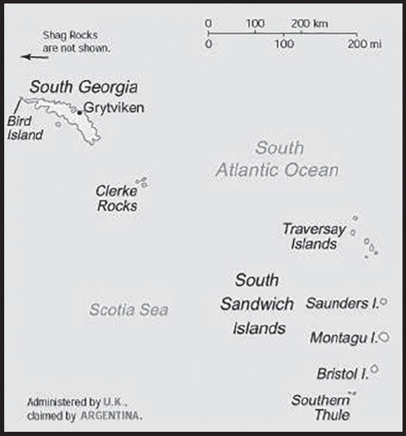
Background: The islands, with large bird and seal populations, lie approximately 1,000 km east of the Falkland Islands and have been under British administration since 1908 - except for a brief period in 1982 when Argentina occupied them. Grytviken, on South Georgia, was a 19th and early 20th century whaling station. Famed explorer Ernest SHACKLETON stopped there in 1914 en route to his ill-fated attempt to cross Antarctica on foot. He returned some 20 months later with a few companions in a small boat and arranged a successful rescue for the rest of his crew, stranded off the Antarctic Peninsula. He died in 1922 on a subsequent expedition and is buried in Grytviken. Today, the station houses scientists from the British Antarctic Survey. Recognizing the importance of preserving the marine stocks in adjacent waters, the UK, in 1993, extended the exclusive fishing zone from 12 nm to 200 nm around each island.
GEOGRAPHY
Location: Southern South America, islands in the South Atlantic Ocean, east of the tip of South America
Geographic coordinates: 54 30 S, 37 00 W
Map references: Antarctic Region
Area: total: 3,903 sq km
land: 3,903 sq km
water: 0 sq km
note: includes Shag Rocks, Black Rock, Clerke Rocks, South Georgia Island, Bird Island, and the South Sandwich Islands, which consist of 11 islands
comparison ranking: total 176
Area - comparative: slightly larger than Rhode Island
Land boundaries: total: 0 km
Maritime claims: territorial sea: 12 nm
exclusive fishing zone: 200 nm
Climate: variable, with mostly westerly winds throughout the year interspersed with periods of calm; nearly all precipitation falls as snow
Terrain: most of the islands are rugged and mountainous rising steeply from the sea; South Georgia is largely barren with steep, glacier-covered mountains; the South Sandwich Islands are of volcanic origin with some active volcanoes
Elevation: highest point: Mount Paget (South Georgia) 2,934 m
lowest point: Atlantic Ocean 0 m
Natural resources: fish
Land use: other: 100% (2018 est.)
Irrigated land: 0 sq km (2022)
Natural hazards: the South Sandwich Islands have prevailing weather conditions that generally make them difficult to approach by ship; they are also subject to active volcanism
Geography - note: the north coast of South Georgia has several large bays, which provide good anchorage
PEOPLE AND SOCIETY
Population: (July 2021 est.) no indigenous inhabitants
note: the small military garrison on South Georgia withdrew in March 2001, replaced by a permanent group of scientists of the British Antarctic Survey, which also has a biological station on Bird Island; the South Sandwich Islands are uninhabited
Net migration rate: 5.9 migrant(s)/1,000 population
comparison ranking: 19
ENVIRONMENT
Environment - current issues: reindeer - introduced to the islands in the 20th century - devastated the native flora and bird species; some reindeer were translocated to the Falkland Islands in 2001, the rest were exterminated (2013-14); a parallel effort (2010-15) eradicated rats and mice that came to the islands as stowaways on ships as early as the late 18th century
Climate: variable, with mostly westerly winds throughout the year interspersed with periods of calm; nearly all precipitation falls as snow
Land use: other: 100% (2018 est.)
GOVERNMENT
Country name: conventional long form: South Georgia and the South Sandwich Islands
conventional short form: South Georgia and South Sandwich Islands
abbreviation: SGSSI
etymology: South Georgia was named “the Isle of Georgia” in 1775 by Captain James COOK in honor of British King GEORGE III; the explorer also discovered the Sandwich Islands Group that year, which he named “Sandwich Land” after John MONTAGU, the Earl of Sandwich and First Lord of the Admiralty; the word “South” was later added to distinguish these islands from the other Sandwich Islands, now known as the Hawaiian Islands
Dependency status: overseas territory of the UK, also claimed by Argentina; administered from the Falkland Islands by a commissioner, who is concurrently governor of the Falkland Islands, representing King CHARLES III
Legal system: the laws of the UK, where applicable, apply
International organization participation: UPU
Diplomatic representation in the US: none (overseas territory of the UK, also claimed by Argentina)
Diplomatic representation from the US: none (overseas territory of the UK, also claimed by Argentina)
Flag description: blue with the flag of the UK in the upper hoist-side quadrant and the South Georgia and South Sandwich Islands coat of arms centered on the outer half of the flag; the coat of arms features a shield with a golden lion rampant, holding a torch; the shield is supported by a fur seal on the left and a Macaroni penguin on the right; a reindeer appears above the crest, and below the shield on a scroll is the motto LEO TERRAM PROPRIAM PROTEGAT (Let the Lion Protect its Own Land); the lion with the torch represents the UK and discovery; the background of the shield, blue and white estoiles, are found in the coat of arms of James Cook, discoverer of the islands; all the outer supporting animals represented are native to the islands
TRANSPORTATION
Ports and terminals: major seaport(s): Grytviken
MILITARY AND SECURITY
Military - note: defense is the responsibility of the UK
TRANSNATIONAL ISSUES
Disputes - international: South Georgia and South Sandwich Islands (UK)-Argentina: Argentina, which claims the islands in its constitution and briefly occupied them by force in 1982, agreed in 1995 to no longer seek settlement by force
SOUTH SUDAN
INTRODUCTION
Background: South Sudan, which gained independence from Sudan on 9 July 2011, is the world’s newest country. Home to a diverse array of mainly Nilotic ethnolinguistic groups that settled in the territory in the 15th through 19th centuries, South Sudanese society is heavily dependent on seasonal fluctuations in precipitation and seasonal migration. The land comprising modern-day South Sudan was conquered first by Egypt and later ruled jointly by Egyptian-British colonial administrators in the late 19th century. Christian missionaries propagated the spread of English and Christianity, rather than Arabic and Islam, leading to significant cultural differences between the northern and southern parts of Sudan. When Sudan gained its independence in 1956, the Southern region received assurances that it would participate fully in the political system. However, the Arab government in Khartoum reneged on its promises, prompting two periods of civil war (1955-1972 and 1983-2005) in which as many as 2.5 million people died - mostly civilians - due largely to starvation and drought. The Second Sudanese civil war was one of the deadliest since WWII and left Southern Sudanese society devastated by humanitarian crises and economic deterioration. Peace talks resulted in a US-backed Comprehensive Peace Agreement, signed in January 2005, which granted the South a six-year period of autonomy followed by a referendum on final status. The result of this referendum, held in January 2011, was a vote of 98% in favor of secession.
Since independence, South Sudan has struggled to form a viable governing system and has been plagued by widespread corruption, political conflict, and communal violence. In December 2013, conflict erupted between forces loyal to President Salva KIIR, a Dinka, and forces loyal to Vice President Riek MACHAR, a Nuer. The conflict quickly spread throughout the country and unfolded along ethnic lines, killing tens of thousands and creating a dire humanitarian crisis, with millions of South Sudanese displaced and food insecure. KIIR and MACHAR signed a peace agreement in August 2015 that created a Transitional Government of National Unity in April 2016. However, in July 2016, renewed fighting broke out in Juba between KIIR and MACHAR’s forces, plunging the country back into conflict and drawing in additional armed opposition groups, including those in the southern Equatoria region that had largely stayed out of the first round of civil war. A “revitalized” peace agreement was signed in September 2018, which mostly ended the fighting. The government and most armed opposition groups agreed that they would form a unified national army, create a transitional government by May 2019, and prepare for elections in December 2022. Subsequent extensions pushed elections to late 2023, and the transitional government was formed in February 2020, when MACHAR returned to Juba as first vice president. Since 2020, implementation of the peace agreement has been stalled as the parties wrangle over power-sharing arrangements, contributing to an uptick in communal violence and the country’s worst food security crisis since independence, with 7 of 11 million South Sudanese citizens in need of humanitarian assistance.
GEOGRAPHY
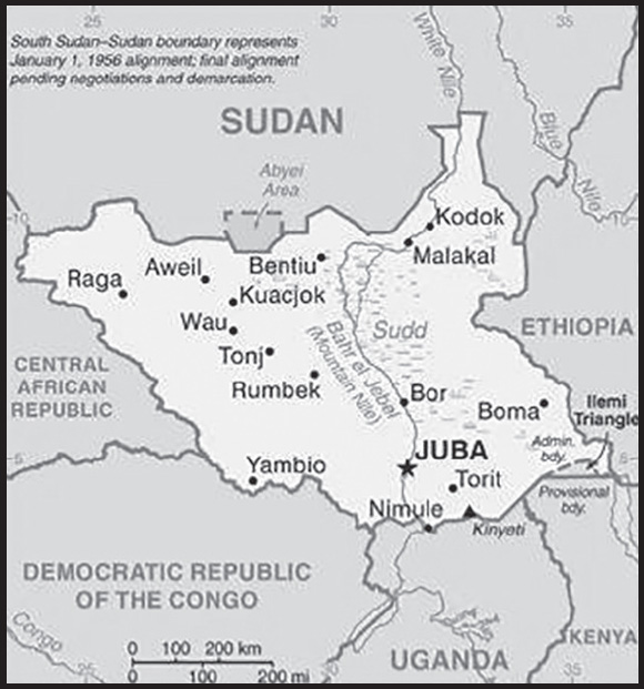
Location: East-Central Africa; south of Sudan, north of Uganda and Kenya, west of Ethiopia
Geographic coordinates: 8 00 N, 30 00 E
Map references: Africa
Area: total: 644,329 sq km
comparison ranking: total 44
Area - comparative: more than four times the size of Georgia; slightly smaller than Texas
Land boundaries: total: 6,018 km
border countries (6): Central African Republic 1,055 km; Democratic Republic of the Congo 714 km; Ethiopia 1,299 km; Kenya 317 km; Sudan 2,158 km; Uganda 475 km
note: South Sudan-Sudan boundary represents 1 January 1956 alignment; final alignment pending negotiations and demarcation; final sovereignty status of Abyei Area pending negotiations between South Sudan and Sudan
Coastline: 0 km (landlocked)
Maritime claims: none (landlocked)
Climate: hot with seasonal rainfall influenced by the annual shift of the Inter-Tropical Convergence Zone; rainfall heaviest in upland areas of the south and diminishes to the north
Terrain: plains in the north and center rise to southern highlands along the border with Uganda and Kenya; the White Nile, flowing north out of the uplands of Central Africa, is the major geographic feature of the country; The Sudd (a name derived from floating vegetation that hinders navigation) is a large swampy area of more than 100,000 sq km fed by the waters of the White Nile that dominates the center of the country
Elevation: highest point: Kinyeti 3,187 m
lowest point: White Nile 381 m
Natural resources: hydropower, fertile agricultural land, gold, diamonds, petroleum, hardwoods, limestone, iron ore, copper, chromium ore, zinc, tungsten, mica, silver
Land use: agricultural land: 45% (2018)
arable land: 4.4% (2018)
permanent pasture: 40.7% (2018)
forest: 11.3% (2018)
other: 43.5% (2018)
Irrigated land: 1,000 sq km (2012)
Major rivers (by length in km): Nile (shared with Rwanda [s], Tanzania, Uganda, Sudan, and Egypt [m]) - 6,650 km
note – [s] after country name indicates river source; [m] after country name indicates river mouth
Major watersheds (area sq km): Atlantic Ocean drainage: Congo (3,730,881 sq km), (Mediterranean Sea) Nile (3,254,853 sq km)
Population distribution: clusters found in urban areas, particularly in the western interior and around the White Nile as shown in this population distribution map
Geography - note: landlocked; The Sudd is a vast swamp in the north central region of South Sudan, formed by the White Nile, its size is variable but can reach some 15% of the country’s total area during the rainy season; it is one of the world’s largest wetlands
PEOPLE AND SOCIETY
Population: 12,118,379 (2023 est.)
comparison ranking: 80
Nationality: noun: South Sudanese (singular and plural)
adjective: South Sudanese
Ethnic groups: Dinka (Jieng) approximately 35-40%, Nuer (Naath) approximately 15%, Shilluk (Chollo), Azande, Bari, Kakwa, Kuku, Murle, Mandari, Didinga, Ndogo, Bviri, Lndi, Anuak, Bongo, Lango, Dungotona, Acholi, Baka, Fertit (2011 est.)
note: Figures are estimations due to population changes during South Sudan’s civil war and the lack of updated demographic studies
Languages: English (official), Arabic (includes Juba and Sudanese variants), ethnic languages include Dinka, Nuer, Bari, Zande, Shilluk
major-language sample(s):

(Arabic)
Religions: Christian 60.5%, folk religion 32.9%, Muslim 6.2%, other <1%, unaffiliated <1% (2020 est.)
Demographic profile: South Sudan, independent from Sudan since July 2011 after decades of civil war, is one of the world’s poorest countries and ranks among the lowest in many socioeconomic categories. Problems are exacerbated by ongoing tensions with Sudan over oil revenues and land borders, fighting between government forces and rebel groups, and inter-communal violence. Most of the population lives off of farming, while smaller numbers rely on animal husbandry; abput 80% of the populace lives in rural areas. The maternal mortality rate is among the world’s highest for a variety of reasons, including a shortage of health care workers, facilities, and supplies; poor roads and a lack of transport; and cultural beliefs that prevent women from seeking obstetric care. Most women marry and start having children early, giving birth at home with the assistance of traditional birth attendants, who are unable to handle complications.
Educational attainment is extremely poor due to the lack of schools, qualified teachers, and materials. Only one-third of the population is literate (the rate is even lower among women), and half live below the poverty line. Teachers and students are also struggling with the switch from Arabic to English as the language of instruction. Many adults missed out on schooling because of warfare and displacement.
More than 2 million South Sudanese have sought refuge in neighboring countries since the current conflict began in December 2013. Another 2.2 million South Sudanese are internally displaced as of October 2022. Despite South Sudan’s instability and lack of infrastructure and social services, more than 275,000 people had fled to South Sudan to escape fighting in Sudan as of December 2022.
Age structure: 0-14 years: 41.93% (male 2,591,637/female 2,490,026)
15-64 years: 55.48% (male 3,426,822/female 3,296,113)
65 years and over: 2.59% (2023 est.) (male 174,080/female 139,701)
Dependency ratios: total dependency ratio: 80.8
youth dependency ratio: 74.7
elderly dependency ratio: 6.1
potential support ratio: 18.4 (2021 est.)
Median age: total: 18.7 years (2023 est.)
male: 18.7 years
female: 18.6 years
comparison ranking: total 215
Population growth rate: 4.78% (2023 est.)
comparison ranking: 2
Birth rate: 37.1 births/1,000 population (2023 est.)
comparison ranking: 9
Death rate: 9.2 deaths/1,000 population (2023 est.)
comparison ranking: 55
Net migration rate: 20 migrant(s)/1,000 population (2023 est.)
comparison ranking: 3
Population distribution: clusters found in urban areas, particularly in the western interior and around the White Nile as shown in this population distribution map
Urbanization: urban population: 21.2% of total population (2023)
rate of urbanization: 4.12% annual rate of change (2020-25 est.)
Major urban areas - population: 459,000 JUBA (capital) (2023)
Sex ratio: at birth: 1.05 male(s)/female
0-14 years: 1.04 male(s)/female
15-64 years: 1.04 male(s)/female
65 years and over: 1.25 male(s)/female
total population: 1.05 male(s)/female (2023 est.)
Maternal mortality ratio: 1,223 deaths/100,000 live births (2020 est.)
comparison ranking: 1
Infant mortality rate: total: 61.6 deaths/1,000 live births (2023 est.)
male: 67.4 deaths/1,000 live births
female: 55.6 deaths/1,000 live births
comparison ranking: total 8
Life expectancy at birth: total population: 59.7 years (2023 est.)
male: 57.9 years
female: 61.6 years
comparison ranking: total population 221
Total fertility rate: 5.2 children born/woman (2023 est.)
comparison ranking: 9
Gross reproduction rate: 2.54 (2023 est.)
Drinking water source: improved: urban: 88.7% of population
rural: 75.8% of population
total: 78.4% of population
unimproved: urban: 11.3% of population
rural: 24.2% of population
total: 21.6% of population (2020 est.)
Current health expenditure: 5.3% of GDP (2020)
Physicians density: (2018)
Sanitation facility access: improved: urban: 60.6% of population
rural: 15.5% of population
total: 24.6% of population
unimproved: urban: 39.4% of population
rural: 84.5% of population
total: 75.4% of population (2020 est.)
Major infectious diseases: degree of risk: very high (2023)
food or waterborne diseases: bacterial and protozoal diarrhea, hepatitis A and E, and typhoid fever
vectorborne diseases: malaria, dengue fever, Trypanosomiasis-Gambiense (African sleeping sickness)
water contact diseases: schistosomiasis
animal contact diseases: rabies
respiratory diseases: meningococcal meningitis
Obesity - adult prevalence rate: 6.6% (2014)
comparison ranking: 166
Currently married women (ages 15-49): 72% (2023 est.)
Education expenditures: 1.5% of GDP (2016 est.)
comparison ranking: 191
Literacy: definition: age 15 and over can read and write
total population: 34.5%
male: 40.3%
female: 28.9% (2018)
Youth unemployment rate (ages 15-24): total: 21% (2021 est.)
male: 21.8%
female: 20.2%
comparison ranking: total 76
ENVIRONMENT
Environment - current issues: water pollution; inadequate supplies of potable water; wildlife conservation and loss of biodiversity; deforestation; soil erosion; desertification; periodic drought
Environment - international agreements: party to: Biodiversity, Climate Change, Climate Change-Paris Agreement, Desertification, Ozone Layer Protection, Wetlands
signed, but not ratified: none of the selected agreements
Climate: hot with seasonal rainfall influenced by the annual shift of the Inter-Tropical Convergence Zone; rainfall heaviest in upland areas of the south and diminishes to the north
Land use: agricultural land: 45% (2018)
arable land: 4.4% (2018)
permanent pasture: 40.7% (2018)
forest: 11.3% (2018)
other: 43.5% (2018)
Urbanization: urban population: 21.2% of total population (2023)
rate of urbanization: 4.12% annual rate of change (2020-25 est.)
Food insecurity: widespread lack of access: due to economic downturn, the lingering effects of floods, and prolonged internal conflict - despite sustained humanitarian assistance, food insecurity still affects large segments of the population, owing to rampant inflation and insufficient food supplies due to stagnant agricultural production, the effects of consecutive years with widespread floods, and the escalation of organized violence at the subnational level since 2020; about 7.76 million people, almost two thirds of the total population, are expected to face severe acute food insecurity in the lean season between April and July 2023 (2023)
Revenue from forest resources: 2.65% of GDP (2015 est.)
comparison ranking: 25
Air pollutants: particulate matter emissions: 20.18 micrograms per cubic meter (2019 est.)
carbon dioxide emissions: 1.73 megatons (2016 est.)
methane emissions: 7.61 megatons (2020 est.)
Waste and recycling: municipal solid waste generated annually: 2,680,681 tons (2013 est.)
Major rivers (by length in km): Nile (shared with Rwanda [s], Tanzania, Uganda, Sudan, and Egypt [m]) - 6,650 km
note – [s] after country name indicates river source; [m] after country name indicates river mouth
Major watersheds (area sq km): Atlantic Ocean drainage: Congo (3,730,881 sq km), (Mediterranean Sea) Nile (3,254,853 sq km)
Total water withdrawal: municipal: 190 million cubic meters (2020 est.)
industrial: 230 million cubic meters (2020 est.)
agricultural: 240 million cubic meters (2020 est.)
Total renewable water resources: 49.5 billion cubic meters (2020 est.)
GOVERNMENT
Country name: conventional long form: Republic of South Sudan
conventional short form: South Sudan
etymology: self-descriptive name from the country’s former position within Sudan prior to independence; the name “Sudan” derives from the Arabic “bilad-as-sudan” meaning “Land of the Black [peoples]”
Government type: presidential republic
Capital: name: Juba
geographic coordinates: 04 51 N, 31 37 E
time difference: UTC+2 (8 hours ahead of Washington, DC, during Standard Time)
etymology: the name derives from Djouba, another name for the Bari people of South Sudan
Administrative divisions: 10 states; Central Equatoria, Eastern Equatoria, Jonglei, Lakes, Northern Bahr el Ghazal, Unity, Upper Nile, Warrap, Western Bahr el Ghazal, Western Equatoria; note - in 2015, the creation of 28 new states was announced and in 2017 four additional states; following the February 2020 peace agreement, the country was again reorganized into the 10 original states, plus 2 administrative areas, Pibor and Ruweng, and 1 special administrative status area, Abyei (which is disputed between South Sudan and Sudan); this latest administrative revision has not yet been vetted by the US Board on Geographic Names
Independence: 9 July 2011 (from Sudan)
National holiday: Independence Day, 9 July (2011)
Constitution: history: previous 2005 (preindependence); latest signed 7 July 2011, effective 9 July 2011 (Transitional Constitution of the Republic of South Sudan, 2011); note - new constitution pending establishment under the 2018 peace agreement
amendments: proposed by the National Legislature or by the president of the republic; passage requires submission of the proposal to the Legislature at least one month prior to consideration, approval by at least two-thirds majority vote in both houses of the Legislature, and assent of the president; amended 2013, 2015, 2018
Citizenship: citizenship by birth: no
citizenship by descent only: at least one parent must be a citizen of South Sudan
dual citizenship recognized: yes
residency requirement for naturalization: 10 years
Suffrage: 18 years of age; universal
Executive branch: chief of state: President Salva KIIR Mayardit (since 9 July 2011); Vice Presidents Riek MACHAR Teny Dhurgon, TABAN Deng Gai, James Wani IGGA, Rebecca Nyandeng Chol GARANG de Mabior, Hussein ABDELBAGI Ayii (since 22 February 2020); note - the president is both chief of state and head of government
head of government: President Salva KIIR Mayardit (since 9 July 2011); Vice Presidents Riek MACHAR Teny Dhurgon, TABAN Deng Gai, James Wani IGGA, Rebecca Nyandeng Chol GARANG de Mabior, Hussein ABDELBAGI Ayii (since 22 February 2020)
cabinet: National Council of Ministers appointed by the president, approved by the Transitional National Legislative Assembly
elections/appointments: president directly elected by simple majority popular vote for a 4-year term (eligible for a second term); election last held on 11-15 April 2010 (originally scheduled for 2015 but postponed several times, currently to 2024)
election results: Salva KIIR Mayardit elected leader of then-Southern Sudan in 2010; percent of vote - Salva KIIR Mayardit (SPLM) 93%, Lam AKOL (SPLM-DC) 7%
Legislative branch: description: bicameral National Legislature consists of:
Council of States, pending establishment as stipulated by the 2018 peace deal
Transitional National Legislative Assembly (TNLA), established on 4 August 2016, in accordance with the August 2015 Agreement on the Resolution of the Conflict in the Republic of South Sudan; note - originally 400 seats; the TNLA was expanded to 550 members from 400 and reestablished in May 2020 under the 2018 peace agreement
elections: Council of States - pending establishment as stipulated by the 2018 peace deal
Transitional National Legislative Assembly - 550 members; percent of vote by party - NA; seats by party - 332 SPLM, 128 SPLM-IO, 90 other political parties; composition - NA
election results: Council of States - percent of vote by party - NA; seats by party - SPLM 20, unknown 30; composition - men 44, women 6, percent of women 12%
National Legislative Assembly - percent of vote by party - NA; seats by party - SPLM 251, DCP 10, independent 6, unknown 133; composition - men 291, women 109, percent of women 27.3%; note - total National Legislature percent of women 25.6%
Judicial branch: highest court(s): Supreme Court of South Sudan (consists of a chief justice, deputy chief justice, and 5 additional justices); note - consistent with the 2008 Judiciary Act, the Transitional Constitution of South Sudan calls for 9, rather than 5 additional justices
judge selection and term of office: justices appointed by the president (the 2011 Transitional Constitution of South Sudan calls for the establishment of a Judicial Service Council to recommend prospective justices to the president, and for the justices’ tenures to be set by the National Legislature; neither of these steps have been effectively implemented as of mid-2023)
subordinate courts: national level - Courts of Appeal; High Courts; County Courts; state level - High Courts; County Courts; customary courts; other specialized courts and tribunals
Note: in mid-2022, the Government of South Sudan inaugurated an Ad-hoc Judiciary Committee, a 12-member body led by two eminent jurists, which is charged with reviewing relevant laws, advising on judicial reform and restructuring of the judiciary
Political parties and leaders: Democratic Change or DC
Democratic Forum or DF
Labour Party or LPSS [Federico Awi VUNI]
South Sudan Opposition Alliance or SSOA [Hussein ABDELBAGI Ayii]
Sudan African National Union or SANU [Toby MADOUT]
Sudan People’s Liberation Movement or SPLM [Salva KIIR Mayardit]
Sudan People’s Liberation Movement-In Opposition or SPLM-IO [Riek MACHAR Teny Dhurgon]
United Democratic Salvation Front or UDSF
United South Sudan African Party or USSAP [Louis Pasquale ALEU, Secretary]
United South Sudan Party or USSP [Paulino LUKUDU Obede]
note: only parties with seats in the Transitional National Legislative Assembly included
International organization participation: AU, FAO, G-77, IBRD, ICAO, IDA, IFAD, IFC, IFRCS, IGAD, ILO, IMF, Interpol, IOM, IPU, ITU, MIGA, UN, UNCTAD, UNESCO, UPU, WCO, WHO, WMO
Diplomatic representation in the US: chief of mission: Ambassador Philip Jada NATANA (since 17 September 2018)
chancery: 1015 31st Street NW, Suite 300, Washington, DC 20007
telephone: [1] (202) 600-2238
FAX: [1] (202) 644-9910
email address and website:
https://www.southsudanembassyusa.org/
Diplomatic representation from the US: chief of mission: Ambassador Michael J. ADLER (since 24 August 2022)
embassy: Kololo Road adjacent to the EU’s compound, Juba
mailing address: 4420 Juba Place, Washington DC 20521-4420
telephone: [211] 912-105-188
email address and website:
Flag description: three equal horizontal bands of black (top), red, and green; the red band is edged in white; a blue isosceles triangle based on the hoist side contains a gold, five-pointed star; black represents the people of South Sudan, red the blood shed in the struggle for freedom, green the verdant land, and blue the waters of the Nile; the gold star represents the unity of the states making up South Sudan
note: resembles the flag of Kenya; one of only two national flags to display six colors as part of its primary design, the other is South Africa’s
National symbol(s): African fish eagle; national colors: red, green, blue, yellow, black, white
National anthem: name: “South Sudan Oyee!” (Hooray!)
lyrics/music: collective of 49 poets/Juba University students and teachers
note: adopted 2011; anthem selected in a national contest
ECONOMY
Economic overview: low-income, oil-based Sahelian economy; extreme poverty and food insecurity; COVID-19 and ongoing violence threaten socioeconomic potential; environmentally fragile; ongoing land and property rights issues; natural resource rich but lacks infrastructure
Real GDP (purchasing power parity): $20.01 billion (2017 est.)
$21.1 billion (2016 est.)
$24.52 billion (2015 est.)
note: data are in 2017 dollars
comparison ranking: 152
Real GDP growth rate: -5.2% (2017 est.)
-13.9% (2016 est.)
-0.2% (2015 est.)
comparison ranking: 212
Real GDP per capita: $1,600 (2017 est.)
$1,700 (2016 est.)
$2,100 (2015 est.)
note: data are in 2017 dollars
comparison ranking: 216
GDP (official exchange rate): $3.06 billion (2017 est.)
Inflation rate (consumer prices): 10.52% (2021 est.)
29.68% (2020 est.)
87.24% (2019 est.)
comparison ranking: 23
GDP - composition, by end use: household consumption: 34.9% (2011 est.)
government consumption: 17.1% (2011 est.)
investment in fixed capital: 10.4% (2011 est.)
exports of goods and services: 64.9% (2011 est.)
imports of goods and services: -27.2% (2011 est.)
Agricultural products: milk, sorghum, vegetables, cassava, goat milk, fruit, beef, sesame seed, sheep milk, mutton
Labor force: 4.278 million (2021 est.)
comparison ranking: 94
Unemployment rate: 13.91% (2021 est.)
14.03% (2020 est.)
12.23% (2019 est.)
comparison ranking: 44
Youth unemployment rate (ages 15-24): total: 21% (2021 est.)
male: 21.8%
female: 20.2%
comparison ranking: total 76
Population below poverty line: 76.4% (2016 est.)
Gini Index coefficient - distribution of family income: 44.1 (2016 est.)
comparison ranking: 30
Budget: revenues: $1.94 billion (2019 est.)
expenditures: $1.938 billion (2019 est.)
Budget surplus (+) or deficit (-): -1.3% (of GDP) (FY2017/18 est.)
comparison ranking: 85
Public debt: 62.7% of GDP (2017 est.)
86.6% of GDP (2016 est.)
comparison ranking: 77
Taxes and other revenues: 8.5% (of GDP) (FY2017/18 est.)
comparison ranking: 206
Current account balance: -$6.55 million (2021 est.)
-$1.718 billion (2020 est.)
-$193.95 million (2019 est.)
comparison ranking: 81
Exports: $4.652 billion (2021 est.) note: data are in current year dollars
$2.344 billion (2020 est.) note: data are in current year dollars
$3.641 billion (2019 est.)
comparison ranking: 132
Exports - partners: China 88%, United Arab Emirates 5% (2019)
Exports - commodities: crude petroleum, gold, forage crops, lumber, insect resins (2019)
Imports: $4.037 billion (2021 est.) note: data are in current year dollars
$4.245 billion (2020 est.) note: data are in current year dollars
$3.893 billion (2019 est.)
comparison ranking: 152
Imports - partners: United Arab Emirates 37%, Kenya 18%, China 18% (2019)
Imports - commodities: cars, delivery trucks, packaged medicines, foodstuffs, clothing and apparel (2019)
Reserves of foreign exchange and gold: $183,614,800 (31 December 2020 est.)
$378,281,700 (31 December 2019 est.)
$36,396,400 (31 December 2018 est.)
comparison ranking: 186
Exchange rates: South Sudanese pounds (SSP) per US dollar -
Exchange rates:
306.355 (2021 est.)
165.907 (2020 est.)
157.999 (2019 est.)
141.386 (2018 est.)
113.648 (2017 est.)
ENERGY
Electricity access: population without electricity: 10 million (2020)
electrification - total population: 7.7% (2021)
electrification - urban areas: 15.5% (2021)
electrification - rural areas: 5.7% (2021)
Electricity: installed generating capacity: 121,000 kW (2020 est.)
consumption: 531.66 million kWh (2019 est.)
exports: 0 kWh (2019 est.)
imports: 0 kWh (2019 est.)
transmission/distribution losses: 26 million kWh (2019 est.)
comparison rankings: installed generating capacity 181; transmission/distribution losses 180; imports 123; exports 103; consumption 170
Electricity generation sources: fossil fuels: 99.2% of total installed capacity (2020 est.)
solar: 0.8% of total installed capacity (2020 est.)
Petroleum: total petroleum production: 157,100 bbl/day (2021 est.)
refined petroleum consumption: 12,900 bbl/day (2019 est.)
crude oil and lease condensate exports: 126,500 bbl/day (2018 est.)
Refined petroleum products - imports: 7,160 bbl/day (2015 est.)
comparison ranking: 157
Carbon dioxide emissions: 1.778 million metric tonnes of CO2 (2019 est.)
from petroleum and other liquids: 1.778 million metric tonnes of CO2 (2019 est.)
comparison ranking: total emissions 161
Energy consumption per capita: 2.404 million Btu/person (2019 est.)
comparison ranking: 185
COMMUNICATIONS
Telephones - fixed lines: total subscriptions: (2018 est.)
subscriptions per 100 inhabitants: (2018 est.)
Telephones - mobile cellular: total subscriptions: 3.3 million (2021 est.)
subscriptions per 100 inhabitants: 30 (2021 est.)
comparison ranking: total subscriptions 139
Telecommunication systems: general assessment: following a referendum, oil-rich South Sudan seceded from Sudan in 2011 and became an independent nation; having been deprived of investment for decades, it inherited one of the least developed telecom markets in the world; there was once investment activity among mobile network operators who sought to expand their networks in some areas of the country; operators in the telecom sector placed themselves in survival mode and are hoping for a political settlement and a return to some degree of social stability; South Sudan has one of the lowest mobile penetration rates in Africa; growth in the sector in coming years is premised on a resolution to the political crisis and a recovery of the country’s economy; the virtually untapped internet and broadband market also depends to a large extent on the country gaining access to international fiber cables and on a national backbone network being in place; sophisticated infrastructure solutions are needed to reach the 80% of the population that live outside of the main urban centers; some improvement has followed from the cable link in February 2020 which connects Juba directly to the company’s submarine landing station at Mombasa; the cable was South Sudan’s first direct international fiber link, and has helped drive down the price of retail internet services for residential and business customers; a second cable linking to the border with Kenya was completed in December 2021 (2022)
domestic: fixed-line less than 1 per 100 subscriptions, mobile-cellular is 30 per 100 persons (2021)
international: country code - 211 (2017)
Broadcast media: a single TV channel and a radio station are controlled by the government; several community and commercial FM stations are operational, mostly sponsored by outside aid donors; some foreign radio broadcasts are available
(2019)
Internet country code: .ss
Internet users: total: 869,000 (2021 est.)
percent of population: 7.9% (2021 est.)
comparison ranking: total 151
Broadband - fixed subscriptions: total: 200 (2019 est.)
subscriptions per 100 inhabitants: (2019 est.)
comparison ranking: total 212
TRANSPORTATION
National air transport system: number of registered air carriers: 2 (2020)
inventory of registered aircraft operated by air carriers: 2
annual freight traffic on registered air carriers: 0 mt-km
Civil aircraft registration country code prefix: Z8
Airports: 89 (2021)
comparison ranking: total 63
Airports - with paved runways: 4
note: paved runways have a concrete or asphalt surface but not all have facilities for refueling, maintenance, or air traffic control; the length of a runway required for aircraft to safely operate depends on a number of factors including the type of aircraft, the takeoff weight (including passengers, cargo, and fuel), engine types, flap settings, landing speed, elevation of the airport, and average maximum daily air temperature; paved runways can reach a length of 5,000 m (16,000 ft.), but the “typical” length of a commercial airline runway is between 2,500-4,000 m (8,000-13,000 ft.)
Airports - with unpaved runways: 84
note: unpaved runways have a surface composition such as grass or packed earth and are most suited to the operation of light aircraft; unpaved runways are usually short, often less than 1,000 m (3,280 ft.) in length; airports with unpaved runways often lack facilities for refueling, maintenance, or air traffic control
Heliports: 3 (2021)
Railways: total: 248 km (2018)
note: a narrow gauge, single-track railroad between Babonosa (Sudan) and Wau, the only existing rail system, was repaired in 2010 with $250 million in UN funds, but is not currently operational
comparison ranking: total 127
Roadways: total: 90,200 km (2019)
paved: 300 km (2019)
unpaved: 89,900 km (2019)
note: most of the road network is unpaved and much of it is in disrepair; the Juba-Nimule highway connecting Juba to the border with Uganda is the main paved road in South Sudan
comparison ranking: total 54
Waterways: see entry for Sudan
MILITARY AND SECURITY
Military and security forces: South Sudan People’s Defense Force (SSPDF): Ground Force (includes Presidential Guard), Air Force, Air Defense Forces; National (or Necessary) Unified Forces (NUF)
Ministry of Interior: South Sudan National Police Service (2023)
note 1: the NUF are being formed by retraining rebel and pro-government militia fighters into military, police, and other government security forces; the first operational NUF deployed in November 2023
note 2: numerous irregular forces operate in the country with official knowledge, including militias operated by the National Security Service (an internal security force under the Ministry of National Security) and proxy forces
Military expenditures: 2.5% of GDP (2022 est.)
2% of GDP (2021 est.)
2% of GDP (2020 est.)
3.1% of GDP (2019 est.)
3.2% of GDP (2018 est.)
comparison ranking: 40
Military and security service personnel strengths: estimated 150-200,000 active personnel, mostly ground forces with small contingents of air and riverine forces (2023)
note: some active SSPDF personnel may be militia; the National/Necessary Unified Forces (NUF) are expected to have up to 80,000 personnel when training and integration is completed; the first batch of approximately 20,000 NUF personnel completed training in late 2022
Military equipment inventories and acquisitions: the SSPDF inventory is primarily of Soviet origin; South Sudan has been under a UN arms embargo since 2018 (2023)
Military service age and obligation: 18 is the legal minimum age for compulsory (men) and voluntary (men and women) military service; 12-24 months service (2023)
note: in 2019, women made up less than 10% of the active military
Military deployments: in 2023, South Sudan sent approximately 750 troops to the Democratic Republic of the Congo as part of an East Africa Community military peacekeeping force
Military - note: the South Sudan People’s Defense Forces (SSPDF) are largely focused on internal security; the Ground Force has approximately 8 light infantry divisions plus a mechanized presidential guard division (aka the Tiger Division); the Air Force has small numbers of transport aircraft and combat helicopters
the SSPDF, formerly the Sudan People’s Liberation Army (SPLA), was founded as a guerrilla movement against the Sudanese Government in 1983 and participated in the Second Sudanese Civil War (1983-2005); the Juba Declaration that followed the Comprehensive Peace Agreement of 2005 unified the SPLA and the South Sudan Defense Forces (SSDF), the second-largest rebel militia remaining from the civil war, under the SPLA name; in 2017, the SPLA was renamed the South Sudan Defense Forces (SSDF) and in September 2018 was renamed again as the SSPDF
the United Nations Mission in South Sudan (UNMISS) has operated in the country since 2011 with the objectives of consolidating peace and security and helping establish conditions for the successful economic and political development of South Sudan; UNMISS had about 15,000 personnel deployed in the country as of early 2023
United Nations Interim Security Force for Abyei (UNISFA) has operated in the disputed Abyei region along the border between Sudan and South Sudan since 2011; UNISFA’s mission includes ensuring security, protecting civilians, strengthening the capacity of the Abyei Police Service, de-mining, monitoring/verifying the redeployment of armed forces from the area, and facilitating the flow of humanitarian aid; as of 2022, UNISFA had approximately 2,500 military and police personnel (2023)
TRANSNATIONAL ISSUES
Disputes - international: South Sudan- Central African Republic: periodic violent skirmishes persist among related pastoral populations along the border with the Central African Republic over water and grazing rights
South Sudan-Democratic Republic of the Congo: none identified
South Sudan-Ethiopia: the unresolved demarcation of the boundary and lack of clear limitation create substantial room for territorial conflict both locally among the border populations and between the two capitals; besides a large number of indigenous farmers, the border region supports refugees and various rebel groups opposed to the governments in Khartoum and Addis Ababa
South Sudan-Kenya: two thirds of the boundary that separates Kenya and South Sudan’s sovereignty known as the Ilemi Triangle has been unclear since British colonial times; Kenya has administered the area since colonial times; officials from Kenya and South Sudan signed a memorandum of understanding on boundary delimitation and demarcation and agreed to set up a joint committee; as of July 2019, the demarcation process was to begin in 90 days, but was delayed due to a lack of funding
South Sudan-Sudan: present boundary represents 1 January 1956 alignment, which clearly placed the Kafia Kingi area (adjacent to Central African Republic) within South Sudan as shown on US maps although it is mostly occupied by Sudan; final alignment pending negotiations and demarcation; the final sovereignty status of Abyei Area pending negotiations between South Sudan and Sudan; clashes continue in the oil-rich Abyei region; the United Nations interim security Force for Abyei (UNISFA) has been deployed since 2011, when South Sudan became independent, Sudan accuses South Sudan of supporting Sudanese rebel groups
South Sudan-Uganda: none identified
Refugees and internally displaced persons: refugees (country of origin): 254,953 (Sudan) (refugees since 15 April 2023), 13,114 (Democratic Republic of the Congo) (2023)
IDPs: 2.258 million (alleged coup attempt and ethnic conflict beginning in December 2013; information is lacking on those displaced in earlier years by: fighting in Abyei between the Sudanese Armed Forces and the Sudan People’s Liberation Army (SPLA) in May 2011; clashes between the SPLA and dissident militia groups in South Sudan; interethnic conflicts over resources and cattle; attacks from the Lord’s Resistance Army; floods and drought) (2023)
stateless persons: 10,000 (2022)
Trafficking in persons: tier rating: Tier 3 — South Sudan does not fully meet the minimum standards for the elimination of trafficking and is not making significant efforts to do so, therefore it remains on Tier 3; the government took some steps to address trafficking, including convening an inter-ministerial task force, finalizing a National Action plan, and conducting awareness activities; however, there was a government policy or pattern whereby security and law enforcement officers continued to forcibly recruit child soldiers and did not hold any members criminally accountable for these unlawful acts; for the tenth consecutive year, there were no reported investigations into or prosecutions for forced labor or sex trafficking; officials did not report identifying or assisting any victims and continued to penalize victims for unlawful acts traffickers compelled them to commit (2022)
trafficking profile: traffickers exploit domestic and foreign victims in South Sudan and South Sudanese abroad; women and girls, particularly from rural areas or internally displaced, are vulnerable to domestic servitude, and some are exploited by males in the households in sexual abuse or trafficking; South Sudanese girls are exploited in sex trafficking in restaurants, hotels, and brothels—sometimes involving corrupt law enforcement officials; some children are coerced to work in begging, herding, construction, and a wide range of physically demanding labor sectors; men and women recruited from neighboring countries, including the Democratic Republic of the Congo, Eritrea, Ethiopia, Kenya, Republic of the Congo, and Uganda, as well as South Sudanese women and children are recruited with fraudulent employment offers in hotels, restaurants, and construction and forced to work for little or no pay or coerced into commercial sex; government forces use children to fight or serve in support roles; several milliion internally displaced persons and South Sudanese refugees living in neighboring countries are at risk of trafficking, and unaccompanied children in the camps are vulnerable to abduction by sex and labor traffickers (2022)
SOUTHERN OCEAN
INTRODUCTION
Background: A large body of recent oceanographic research has shown that the Antarctic Circumpolar Current (ACC), an ocean current that flows from west to east around Antarctica, plays a crucial role in global ocean circulation. The region where the cold waters of the ACC meet and mingle with the warmer waters of the north defines a distinct border - the Antarctic Convergence - which fluctuates with the seasons, but which encompasses a discrete body of water and a unique ecologic region. The Convergence concentrates nutrients, which promotes marine plant life, and which, in turn, allows for a greater abundance of animal life. In 2000, the International Hydrographic Organization delimited the waters within the Convergence as a fifth world ocean - the Southern Ocean - by combining the southern portions of the Atlantic Ocean, Indian Ocean, and Pacific Ocean. The Southern Ocean extends from the coast of Antarctica north to 60 degrees south latitude, which coincides with the Antarctic Treaty region and which approximates the extent of the Antarctic Convergence. As such, the Southern Ocean is now the fourth largest of the world’s five oceans (after the Pacific Ocean, Atlantic Ocean, and Indian Ocean, but larger than the Arctic Ocean). It should be noted that inclusion of the Southern Ocean does not imply recognition of this feature as one of the world’s primary oceans by the US Government.
GEOGRAPHY
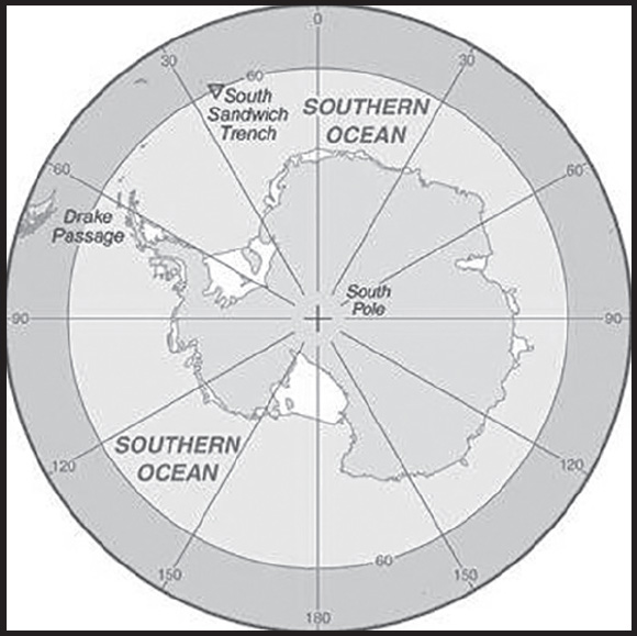
Location: body of water between 60 degrees south latitude and Antarctica
Geographic coordinates: 60 00 S, 90 00 E (nominally), but the Southern Ocean has the unique distinction of being a large circumpolar body of water totally encircling the continent of Antarctica; this ring of water lies between 60 degrees south latitude and the coast of Antarctica and encompasses 360 degrees of longitude
Map references: Antarctic Region
Area: total: 21.96 million sq km
note: includes Amundsen Sea, Bellingshausen Sea, part of the Drake Passage, Ross Sea, a small part of the Scotia Sea, Weddell Sea, and other tributary water bodies
Area - comparative: slightly more than twice the size of the US
Coastline: 17,968 km
Climate: sea temperatures vary from about 10 degrees Celsius to -2 degrees Celsius; cyclonic storms travel eastward around the continent and frequently are intense because of the temperature contrast between ice and open ocean; the ocean area from about latitude 40 south to the Antarctic Circle has the strongest average winds found anywhere on Earth; in winter the ocean freezes outward to 65 degrees south latitude in the Pacific sector and 55 degrees south latitude in the Atlantic sector, lowering surface temperatures well below 0 degrees Celsius; at some coastal points intense persistent drainage winds from the interior keep the shoreline ice-free throughout the winter
Ocean volume: ocean volume: 71.8 million cu km
percent of World Ocean total volume: 5.4%
Major ocean currents: the cold, clockwise-flowing Antarctic Circumpolar Current (West Wind Drift; 21,000 km long) moves perpetually eastward around the continent and is the world’s largest and strongest ocean current, transporting 130 million cubic meters of water per second - 100 times the flow of all the world’s rivers; it is also the only current that flows all the way around the planet and connects the Atlantic, Pacific, and Indian Oceans; the cold Antarctic Coastal Current (East Wind Drift) is the southernmost current in the world, flowing westward and parallel to the Antarctic coastline
Elevation: highest point: sea level
lowest point: southern end of the South Sandwich Trench -7,434 m unnamed deep
mean depth: -3,270 m
ocean zones: Composed of water and in a fluid state, the oceans are delimited differently than the solid continents. Oceans are divided into three zones based on depth and light level. Although some sea creatures depend on light to live, others can do without it. Sunlight entering the water may travel about 1,000 m into the oceans under the right conditions, but there is rarely any significant light beyond 200 m.
The upper 200 m (656 ft) of oceans is called the euphotic, or “sunlight,” zone. This zone contains the vast majority of commercial fisheries and is home to many protected marine mammals and sea turtles. Only a small amount of light penetrates beyond this depth.
The zone between 200 m (656 ft) and 1,000 m (3,280 ft) is usually referred to as the “twilight” zone, but is officially the dysphotic zone. In this zone, the intensity of light rapidly dissipates as depth increases. Such a minuscule amount of light penetrates beyond a depth of 200 m that photosynthesis is no longer possible.
The aphotic, or “midnight,” zone exists in depths below 1,000 m (3,280 ft). Sunlight does not penetrate to these depths and the zone is bathed in darkness.
Natural resources: probable large oil and gas fields on the continental margin; manganese nodules, possible placer deposits, sand and gravel, fresh water as icebergs; squid, whales, and seals - none exploited; krill, fish
Natural hazards: huge icebergs with drafts up to several hundred meters; smaller bergs and iceberg fragments; sea ice (generally 0.5 to 1 m thick) with sometimes dynamic short-term variations and with large annual and interannual variations; deep continental shelf floored by glacial deposits varying widely over short distances; high winds and large waves much of the year; ship icing, especially May-October; most of region is remote from sources of search and rescue
Geography - note: the major chokepoint is the Drake Passage between South America and Antarctica; the Polar Front (Antarctic Convergence) is the best natural definition of the northern extent of the Southern Ocean; it is a distinct region at the middle of the Antarctic Circumpolar Current that separates the cold polar surface waters to the south from the warmer waters to the north; the Front and the Current extend entirely around Antarctica, reaching south of 60 degrees south near New Zealand and near 48 degrees south in the far South Atlantic coinciding with the path of the maximum westerly winds
ENVIRONMENT
Environment - current issues: changes to the ocean’s physical, chemical, and biological systems have taken place because of climate change, ocean acidification, and commercial exploitation
Environment - international agreements: the Southern Ocean is subject to all international agreements regarding the world’s oceans; in addition, it is subject to these agreements specific to the Antarctic region: International Whaling Commission (prohibits commercial whaling south of 40 degrees south [south of 60 degrees south between 50 degrees and 130 degrees west]); Convention on the Conservation of Antarctic Seals (limits sealing); Convention on the Conservation of Antarctic Marine Living Resources (regulates fishing) note: mineral exploitation except for scientific research is banned by the Environmental Protocol to the Antarctic Treaty; additionally, many nations (including the US) prohibit mineral resource exploration and exploitation south of the fluctuating Polar Front (Antarctic Convergence), which is in the middle of the Antarctic Circumpolar Current and serves as the dividing line between the cold polar surface waters to the south and the warmer waters to the north
Climate: sea temperatures vary from about 10 degrees Celsius to -2 degrees Celsius; cyclonic storms travel eastward around the continent and frequently are intense because of the temperature contrast between ice and open ocean; the ocean area from about latitude 40 south to the Antarctic Circle has the strongest average winds found anywhere on Earth; in winter the ocean freezes outward to 65 degrees south latitude in the Pacific sector and 55 degrees south latitude in the Atlantic sector, lowering surface temperatures well below 0 degrees Celsius; at some coastal points intense persistent drainage winds from the interior keep the shoreline ice-free throughout the winter
Marine fisheries: the Southern Ocean fishery is relatively small with a total catch of 388,901 mt in 2021; the Food and Agriculture Organization has delineated three regions in the Southern Ocean (Regions 48, 58, 88) that generally encompass the waters south of 40° to 60° South latitude; the most important producers in these regions include Norway (241,408 mt), China (47,605 mt), and South Korea (39,487 mt); Antarctic Krill made up 95.5% of the total catch in 2021, while other important species include Patagonian and Antarctic toothfish
Regional fisheries bodies: Commission on the Conservation of Antarctic Marine Living Resources
GOVERNMENT
Country name: etymology: the International Hydrographic Organization (IHO) included the ocean and its definition as the waters south of 60 degrees south in its year 2000 revision, but this has not formally been adopted; the 2000 IHO definition, however, was circulated in a draft edition in 2002 and has acquired de facto usage by many nations and organizations, including the CIA
TRANSPORTATION
Ports and terminals: major seaport(s): McMurdo, Palmer, and offshore anchorages in Antarctica
note: few ports or harbors exist on the southern side of the Southern Ocean; ice conditions limit use of most to short periods in midsummer; even then some cannot be entered without icebreaker escort; most Antarctic ports are operated by government research stations and, except in an emergency, are not open to commercial or private vessels
Transportation - note: Drake Passage offers alternative to transit through the Panama Canal
TRANSNATIONAL ISSUES
Disputes - international: Antarctica-various: Antarctic Treaty defers claims (see Antarctica entry), but Argentina, Australia, Chile, France, NZ, Norway, and UK assert claims (some overlapping), including the continental shelf in the Southern Ocean; several states have expressed an interest in extending those continental shelf claims under the UN Convention on the Law of the Sea to include undersea ridges; the US and most other states do not recognize the land or maritime claims of other states and have made no claims themselves (the US and Russia have reserved the right to do so); no formal claims exist in the waters in the sector between 90 degrees west and 150 degrees west
SPAIN
INTRODUCTION
Background: Spain’s powerful world empire of the 16th and 17th centuries ultimately yielded command of the seas to England. Subsequent failure to embrace the mercantile and industrial revolutions caused the country to fall behind Britain, France, and Germany in economic and political power. Spain remained neutral in World War I and II but suffered through a devastating civil war (1936-39). A peaceful transition to democracy following the death of dictator Francisco FRANCO in 1975, and rapid economic modernization (Spain joined the EU in 1986) gave Spain a dynamic and rapidly growing economy, and made it a global champion of freedom and human rights. More recently, Spain has emerged from a severe economic recession that began in mid-2008, posting solid years of GDP growth above the EU average. Unemployment has fallen but remains high, especially among youth. Spain is the euro-zone’s fourth-largest economy. The country has faced increased domestic turmoil in recent years due to the independence movement in its restive Catalonia region.
GEOGRAPHY
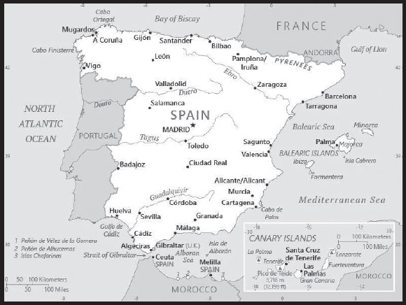
Location: Southwestern Europe, bordering the Mediterranean Sea, North Atlantic Ocean, Bay of Biscay, and Pyrenees Mountains; southwest of France
Geographic coordinates: 40 00 N, 4 00 W
Map references: Europe
Area: total: 505,370 sq km
land: 498,980 sq km
water: 6,390 sq km
note: there are two autonomous cities - Ceuta and Melilla - and 17 autonomous communities including Balearic Islands and Canary Islands, and three small Spanish possessions off the coast of Morocco - Islas Chafarinas, Penon de Alhucemas, and Penon de Velez de la Gomera
comparison ranking: total 54
Area - comparative: almost five times the size of Kentucky; slightly more than twice the size of Oregon
Land boundaries: total: 1,952.7 km
border countries (5): Andorra 63 km; France 646 km; Gibraltar 1.2 km; Portugal 1,224 km; Morocco (Ceuta) 8 km and Morocco (Melilla) 10.5 km
note: an additional 75-meter border segment exists between Morocco and the Spanish exclave of Penon de Velez de la Gomera
Coastline: 4,964 km
Maritime claims: territorial sea: 12 nm
contiguous zone: 24 nm
exclusive economic zone: 200 nm (applies only to the Atlantic Ocean)
Climate: temperate; clear, hot summers in interior, more moderate and cloudy along coast; cloudy, cold winters in interior, partly cloudy and cool along coast
Terrain: large, flat to dissected plateau surrounded by rugged hills; Pyrenees Mountains in north
Elevation: highest point: Pico de Teide (Tenerife) on Canary Islands 3,718 m
lowest point: Atlantic Ocean 0 m
mean elevation: 660 m
Natural resources: coal, lignite, iron ore, copper, lead, zinc, uranium, tungsten, mercury, pyrites, magnesite, fluorspar, gypsum, sepiolite, kaolin, potash, hydropower, arable land
Land use: agricultural land: 54.1% (2018 est.)
arable land: 24.9% (2018 est.)
permanent crops: 9.1% (2018 est.)
permanent pasture: 20.1% (2018 est.)
forest: 36.8% (2018 est.)
other: 9.1% (2018 est.)
Irrigated land: 37,593 sq km (2020)
Major rivers (by length in km): Tagus river source (shared with Portugal [m]) - 1,006
note – [s] after country name indicates river source; [m] after country name indicates river mouth
Population distribution: with the notable exception of Madrid, Sevilla, and Zaragoza, the largest urban agglomerations are found along the Mediterranean and Atlantic coasts; numerous smaller cities are spread throughout the interior reflecting Spain’s agrarian heritage; very dense settlement around the capital of Madrid, as well as the port city of Barcelona
Natural hazards: periodic droughts, occasional flooding
volcanism: volcanic activity in the Canary Islands, located off Africa’s northwest coast; Teide (3,715 m) has been deemed a Decade Volcano by the International Association of Volcanology and Chemistry of the Earth’s Interior, worthy of study due to its explosive history and close proximity to human populations; La Palma (2,426 m), which last erupted in 1971, is the most active of the Canary Islands volcanoes; Lanzarote is the only other historically active volcano
Geography - note: strategic location along approaches to Strait of Gibraltar; Spain controls a number of territories in northern Morocco including the enclaves of Ceuta and Melilla, and the islands of Penon de Velez de la Gomera, Penon de Alhucemas, and Islas Chafarinas; Spain’s Canary Islands are one of four North Atlantic archipelagos that make up Macaronesia; the others are Azores (Portugal), Madeira (Portugal), and Cabo Verde
PEOPLE AND SOCIETY
Population: 47,222,613 (2023 est.)
comparison ranking: 32
Nationality: noun: Spaniard(s)
adjective: Spanish
Ethnic groups: Spanish 84.8%, Moroccan 1.7%, Romanian 1.2%, other 12.3% (2021 est.)
note: data represent population by country of birth
Languages: Castilian Spanish (official nationwide) 74%, Catalan (official in Catalonia, the Balearic Islands, and the Valencian Community (where it is known as Valencian)) 17%, Galician (official in Galicia) 7%, Basque (official in the Basque Country and in the Basque-speaking area of Navarre) 2%, Aranese (official in the northwest corner of Catalonia (Vall d’Aran) along with Catalan, <5,000 speakers); note - Aragonese, Aranese Asturian, Basque, Calo, Catalan, Galician, and Valencian are recognized as regional languages under the European Charter for Regional or Minority Languages
major-language sample(s):
La Libreta Informativa del Mundo, la fuente indispensable de información básica. (Spanish)
Religions: Roman Catholic 58.2%, atheist 16.2%, agnostic 10.8%, other 2.7%, non-believer 10.5%, unspecified 1.7% (2021 est.)
Age structure: 0-14 years: 13.37% (male 3,226,491/female 3,087,271)
15-64 years: 66.13% (male 15,649,418/female 15,577,164)
65 years and over: 20.5% (2023 est.) (male 4,169,949/female 5,512,320)
Dependency ratios: total dependency ratio: 52.4
youth dependency ratio: 21.9
elderly dependency ratio: 30.2
potential support ratio: 3.3 (2021 est.)
Median age: total: 46.3 years (2023 est.)
male: 45.2 years
female: 47.4 years
comparison ranking: total 9
Population growth rate: 0.12% (2023 est.)
comparison ranking: 184
Birth rate: 7.1 births/1,000 population (2023 est.)
comparison ranking: 221
Death rate: 10.1 deaths/1,000 population (2023 est.)
comparison ranking: 34
Net migration rate: 4.2 migrant(s)/1,000 population (2023 est.)
comparison ranking: 28
Population distribution: with the notable exception of Madrid, Sevilla, and Zaragoza, the largest urban agglomerations are found along the Mediterranean and Atlantic coasts; numerous smaller cities are spread throughout the interior reflecting Spain’s agrarian heritage; very dense settlement around the capital of Madrid, as well as the port city of Barcelona
Urbanization: urban population: 81.6% of total population (2023)
rate of urbanization: 0.24% annual rate of change (2020-25 est.)
note: data include Canary Islands, Ceuta, and Melilla
Major urban areas - population: 6.751 million MADRID (capital), 5.687 million Barcelona, 838,000 Valencia (2023)
Sex ratio: at birth: 1.05 male(s)/female
0-14 years: 1.05 male(s)/female
15-64 years: 1 male(s)/female
65 years and over: 0.76 male(s)/female
total population: 0.95 male(s)/female (2023 est.)
Mother’s mean age at first birth: 31.2 years (2020 est.)
Maternal mortality ratio: 3 deaths/100,000 live births (2020 est.)
comparison ranking: 177
Infant mortality rate: total: 2.4 deaths/1,000 live births (2023 est.)
male: 2.7 deaths/1,000 live births
female: 2.2 deaths/1,000 live births
comparison ranking: total 217
Life expectancy at birth: total population: 82.8 years (2023 est.)
male: 80.1 years
female: 85.6 years
comparison ranking: total population 18
Total fertility rate: 1.29 children born/woman (2023 est.)
comparison ranking: 218
Gross reproduction rate: 0.63 (2023 est.)
Contraceptive prevalence rate: 62.1% (2018)
note: percent of women aged 18-49
Drinking water source: improved: urban: 99.9% of population
rural: 100% of population
total: 99.9% of population
unimproved: urban: 0.1% of population
rural: 0% of population
total: 0.1% of population (2020 est.)
Current health expenditure: 10.7% of GDP (2020)
Physicians density: 4.44 physicians/1,000 population (2019)
Hospital bed density: 3 beds/1,000 population (2018)
Sanitation facility access: improved:
total: 100% of population
unimproved: total: 0% of population (2020 est.)
Obesity - adult prevalence rate: 23.8% (2016)
comparison ranking: 62
Alcohol consumption per capita: total: 10.72 liters of pure alcohol (2019 est.)
beer: 4.67 liters of pure alcohol (2019 est.)
wine: 3.52 liters of pure alcohol (2019 est.)
spirits: 2.34 liters of pure alcohol (2019 est.)
other alcohols: 0.19 liters of pure alcohol (2019 est.)
comparison ranking: total 17
Tobacco use: total: 27.7% (2020 est.)
male: 28.6% (2020 est.)
female: 26.7% (2020 est.)
comparison ranking: total 39
Currently married women (ages 15-49): 50.1% (2023 est.)
Education expenditures: 4.6% of GDP (2020 est.)
comparison ranking: 95
Literacy: definition: age 15 and over can read and write
total population: 98.6%
male: 99%
female: 98.2% (2020)
School life expectancy (primary to tertiary education): total: 18 years
male: 18 years
female: 19 years (2020)
Youth unemployment rate (ages 15-24): total: 36.9% (2021 est.)
male: 35.9%
female: 38.2%
comparison ranking: total 22
ENVIRONMENT
Environment - current issues: pollution of the Mediterranean Sea from raw sewage and effluents from the offshore production of oil and gas and drought are negatively impacting water quality and quantity nationwide; air pollution; deforestation; desertification
Environment - international agreements: party to: Air Pollution, Air Pollution-Heavy Metals, Air Pollution-Multi-effect Protocol, Air Pollution-Nitrogen Oxides, Air Pollution-Persistent Organic Pollutants, Air Pollution-Sulphur 94, Air Pollution-Volatile Organic Compounds, Antarctic-Environmental Protection, Antarctic-Marine Living Resources, Antarctic Treaty, Biodiversity, Climate Change, Climate Change-Kyoto Protocol, Climate Change-Paris Agreement, Comprehensive Nuclear Test Ban, Desertification, Endangered Species, Environmental Modification, Hazardous Wastes, Law of the Sea, Marine Dumping-London Convention, Marine Dumping-London Protocol, Marine Life Conservation, Nuclear Test Ban, Ozone Layer Protection, Ship Pollution, Tropical Timber 2006, Wetlands, Whaling
signed, but not ratified: none of the selected agreements
Climate: temperate; clear, hot summers in interior, more moderate and cloudy along coast; cloudy, cold winters in interior, partly cloudy and cool along coast
Land use: agricultural land: 54.1% (2018 est.)
arable land: 24.9% (2018 est.)
permanent crops: 9.1% (2018 est.)
permanent pasture: 20.1% (2018 est.)
forest: 36.8% (2018 est.)
other: 9.1% (2018 est.)
Urbanization: urban population: 81.6% of total population (2023)
rate of urbanization: 0.24% annual rate of change (2020-25 est.)
note: data include Canary Islands, Ceuta, and Melilla
Revenue from forest resources: 0.02% of GDP (2018 est.)
comparison ranking: 144
Revenue from coal: 0% of GDP (2018 est.)
comparison ranking: 163
Air pollutants: particulate matter emissions: 9.34 micrograms per cubic meter (2019 est.)
carbon dioxide emissions: 244 megatons (2016 est.)
methane emissions: 36.94 megatons (2020 est.)
Waste and recycling: municipal solid waste generated annually: 20.151 million tons (2015 est.)
municipal solid waste recycled annually: 3,393,428 tons (2015 est.)
percent of municipal solid waste recycled: 16.8% (2015 est.)
Major rivers (by length in km): Tagus river source (shared with Portugal [m]) - 1,006
note – [s] after country name indicates river source; [m] after country name indicates river mouth
Total water withdrawal: municipal: 4.56 billion cubic meters (2020 est.)
industrial: 5.5 billion cubic meters (2020 est.)
agricultural: 18.96 billion cubic meters (2020 est.)
Total renewable water resources: 111.5 billion cubic meters (2020 est.)
GOVERNMENT
Country name: conventional long form: Kingdom of Spain
conventional short form: Spain
local long form: Reino de Espana
local short form: Espana
etymology: derivation of the name “Espana” is uncertain, but may come from the Phoenician term “span,” related to the word “spy,” meaning “to forge metals,” so, “i-spn-ya” would mean “place where metals are forged”; the ancient Phoenicians long exploited the Iberian Peninsula for its mineral wealth
Government type: parliamentary constitutional monarchy
Capital: name: Madrid
geographic coordinates: 40 24 N, 3 41 W
time difference: UTC+1 (6 hours ahead of Washington, DC, during Standard Time)
daylight saving time: +1hr, begins last Sunday in March; ends last Sunday in October
time zone note: Spain has two time zones, including the Canary Islands (UTC 0)
etymology: the Romans named the original settlement “Matrice” after the river that ran through it; under Arab rule it became “Majerit,” meaning “source of water”; in medieval Romance dialects (Mozarabic) it became “Matrit,” which over time changed to “Madrid”
Administrative divisions: 17 autonomous communities (comunidades autonomas, singular - comunidad autonoma) and 2 autonomous cities* (ciudades autonomas, singular - ciudad autonoma); Andalucia; Aragon; Asturias; Canarias (Canary Islands); Cantabria; Castilla-La Mancha; Castilla-Leon; Cataluna (Castilian), Catalunya (Catalan), Catalonha (Aranese) [Catalonia]; Ceuta*; Comunidad Valenciana (Castilian), Comunitat Valenciana (Valencian) [Valencian Community]; Extremadura; Galicia; Illes Baleares (Balearic Islands); La Rioja; Madrid; Melilla*; Murcia; Navarra (Castilian), Nafarroa (Basque) [Navarre]; Pais Vasco (Castilian), Euskadi (Basque) [Basque Country]
note: the autonomous cities of Ceuta and Melilla plus three small islands of Islas Chafarinas, Penon de Alhucemas, and Penon de Velez de la Gomera, administered directly by the Spanish central government, are all along the coast of Morocco and are collectively referred to as Places of Sovereignty (Plazas de Soberania)
Independence: 1492; the Iberian peninsula was characterized by a variety of independent kingdoms prior to the Muslim occupation that began in the early 8th century A.D. and lasted nearly seven centuries; the small Christian redoubts of the north began the reconquest almost immediately, culminating in the seizure of Granada in 1492; this event completed the unification of several kingdoms and is traditionally considered the forging of present-day Spain
National holiday: National Day (Hispanic Day), 12 October (1492); note - commemorates the arrival of COLUMBUS in the Americas
Constitution: history: previous 1812; latest approved by the General Courts 31 October 1978, passed by referendum 6 December 1978, signed by the king 27 December 1978, effective 29 December 1978
amendments: proposed by the government, by the General Courts (the Congress or the Senate), or by the self-governing communities submitted through the government; passage requires three-fifths majority vote by both houses and passage by referendum if requested by one tenth of the members of either house; proposals disapproved by both houses are submitted to a joint committee, which submits an agreed upon text for another vote; passage requires two-thirds majority vote in Congress and simple majority vote in the Senate; amended 1992, 2011
Legal system: civil law system with regional variations
International law organization participation: accepts compulsory ICJ jurisdiction with reservations; accepts ICCt jurisdiction
Citizenship: citizenship by birth: no
citizenship by descent only: at least one parent must be a citizen of Spain
dual citizenship recognized: only with select Latin American countries
residency requirement for naturalization: 10 years for persons with no ties to Spain
Suffrage: 18 years of age; universal
Executive branch: chief of state: King FELIPE VI (since 19 June 2014); Heir Apparent Princess LEONOR, Princess of Asturias (daughter of the monarch, born 31 October 2005)
head of government: President of the Government of Spain (prime minister-equivalent) Pedro SANCHEZ PEREZ-CASTEJON (since 2 June 2018); Vice President Nadia Maria CALVINO Santamaria (since 12 July 2021)
cabinet: Council of Ministers designated by the president
elections/appointments: the monarchy is hereditary; following legislative elections, the monarch usually proposes as president the leader of the majority party or coalition, who is then indirectly elected by the Congress of Deputies; election last held on 10 November 2019 (next to be held in December 2023); vice president and Council of Ministers appointed by the president
election results: Congress of Deputies vote - NA
note: there is also a Council of State that is the supreme consultative organ of the government, but its recommendations are non-binding
Legislative branch: description: bicameral General Courts or Las Cortes Generales consists of:
Senate or Senado (265 seats; 208 members directly elected in multi-seat constituencies by simple majority vote and 57 members indirectly elected by the legislatures of the autonomous communities; members serve 4-year terms) Congress of Deputies or Congreso de los Diputados (350 seats; 348 members directly elected in 50 multi-seat constituencies by closed-list proportional representation vote, with a 3% threshold needed to gain a seat, and 2 directly elected from the North African Ceuta and Melilla enclaves by simple majority vote; members serve 4-year terms or until the government is dissolved)
elections:
Senate - last held on 23 July 2023 (next to be held no later than July 2027)
Congress of Deputies - last held on 23 July 2023 (next to be held no later than July 2027)
election results:
Senate - percent of vote by party - NA; seats by party - PP 120, PSOE 72, ERC 7, PNV 4, other 5; composition (as of mid-2022) - men 161, women 104; percent of women 39.3%
Congress of Deputies - percent of vote by party - PP 33.1%, PSOE 31.7%, Vox 12.4%, Sumar 12.3%, ERC 1.7%, JuntsxCat 1.6%, EH-Bildu 1.4%, PNV 1.1% other 4.7%; seats by party - PP 136, PSOE 122, Vox 33, Sumar 31, ERC 7, JuntsxCat 7, EH-Bildu 6, PNV 5, other 3; men 196, women 154, percent of women 44%; note - overall General Courts percent of women 42%
Judicial branch: highest court(s): Supreme Court or Tribunal Supremo (consists of the court president and organized into the Civil Room, with a president and 9 judges; the Penal Room, with a president and 14 judges; the Administrative Room, with a president and 32 judges; the Social Room, with a president and 12 judges; and the Military Room, with a president and 7 judges); Constitutional Court or Tribunal Constitucional de Espana (consists of 12 judges)
judge selection and term of office: Supreme Court judges appointed by the monarch from candidates proposed by the General Council of the Judiciary Power, a 20-member governing board chaired by the monarch that includes presidential appointees, lawyers, and jurists confirmed by the National Assembly; judges can serve until age 70; Constitutional Court judges nominated by the National Assembly, executive branch, and the General Council of the Judiciary, and appointed by the monarch for 9-year terms
subordinate courts: National High Court; High Courts of Justice (in each of the autonomous communities); provincial courts; courts of first instance
Political parties and leaders: Asturias Forum or FAC [Carmen MORIYON]
Basque Country Unite (Euskal Herria Bildu) or EH Bildu [Arnaldo OTEGI] (coalition of 4 Basque pro-independence parties)
Basque Nationalist Party or PNV or EAJ [Andoni ORTUZAR]
Canarian Coalition or CC [Fernando Clavijo BATLLE] (coalition of 5 parties)
Ciudadanos Party (Citizens Party) or Cs [Adrian Vazquez LAZARA]
Compromis - Compromise Coalition [Enric MORERA i Català]
Together for Catalonia or JuntsxCat [Albert BATET]
People’s Party or PP [Albert Nunez FEIJOO]
Republican Left of Catalonia or ERC [Oriol JUNQUERAS]
Spanish Socialist Workers Party or PSOE [Pedro SANCHEZ]
Teruel Existe or TE [Tomas GUITARTE]
Unidas (Unite) or Sumar [Yolanda Diaz] (electoral coalition formed in March 2022) (formerly Unidas Podemos or UP)
Union of People of Navarra or UPN [Javier ESPARZA]
Vox or VOX [Santiago ABASCAL]
International organization participation: ADB (nonregional member), AfDB (nonregional member), Arctic Council (observer), Australia Group, BCIE, BIS, CAN (observer), CBSS (observer), CD, CE, CERN, EAPC, EBRD, ECB, EIB, EITI (implementing country), EMU, ESA, EU, FAO, FATF, IADB, IAEA, IBRD, ICAO, ICC (national committees), ICCt, ICRM, IDA, IEA, IFAD, IFC, IFRCS, IHO, ILO, IMF, IMO, IMSO, Interpol, IOC, IOM, IPU, ISO, ITSO, ITU, ITUC (NGOs), LAIA (observer), MIGA, NATO, NEA, NSG, OAS (observer), OECD, OPCW, OSCE, Pacific Alliance (observer), Paris Club, PCA, PIF (partner), Schengen Convention, SELEC (observer), SICA (observer), UN, UNCTAD, UNESCO, UNHCR, UNIDO, UNIFIL, Union Latina, UNOCI, UNRWA, UNWTO, UPU, Wassenaar Arrangement, WCO, WHO, WIPO, WMO, WTO, ZC
Diplomatic representation in the US: chief of mission: Ambassador Santiago CABANAS Ansorena (since 17 September 2018)
chancery: 2375 Pennsylvania Avenue NW, Washington, DC 20037
telephone: [1] (202) 452-0100
FAX: [1] (202) 833-5670
email address and website:
https://www.exteriores.gob.es/Embajadas/washington/en/Paginas/index.aspx
consulate(s) general: Boston, Chicago, Houston, Los Angeles, Miami, New York, San Francisco, San Juan (Puerto Rico)
Diplomatic representation from the US: chief of mission: Ambassador Julissa REYNOSO (since 2 February 2022); note - also accredited to Andorra
embassy: Calle de Serrano, 75, 28006 Madrid
mailing address: 8500 Madrid Place, Washington DC 20521-8500
telephone: [34] (91) 587-2200
FAX: [34] (91) 587-2303
email address and website:
consulate(s) general: Barcelona
Flag description: three horizontal bands of red (top), yellow (double width), and red with the national coat of arms on the hoist side of the yellow band; the coat of arms is quartered to display the emblems of the traditional kingdoms of Spain (clockwise from upper left, Castile, Leon, Navarre, and Aragon) while Granada is represented by the stylized pomegranate at the bottom of the shield; the arms are framed by two columns representing the Pillars of Hercules, which are the two promontories (Gibraltar and Ceuta) on either side of the eastern end of the Strait of Gibraltar; the red scroll across the two columns bears the imperial motto of “Plus Ultra” (further beyond) referring to Spanish lands beyond Europe; the triband arrangement with the center stripe twice the width of the outer dates to the 18th century
note: the red and yellow colors are related to those of the oldest Spanish kingdoms: Aragon, Castile, Leon, and Navarre
National symbol(s): Pillars of Hercules; national colors: red, yellow
National anthem: name: “Himno Nacional Espanol” (National Anthem of Spain)
lyrics/music: no lyrics/unknown
note: officially in use between 1770 and 1931, restored in 1939; the Spanish anthem is the first anthem to be officially adopted, but it has no lyrics; in the years prior to 1931 it became known as “Marcha Real” (The Royal March); it first appeared in a 1761 military bugle call book and was replaced by “Himno de Riego” in the years between 1931 and 1939; the long version of the anthem is used for the king, while the short version is used for the prince, prime minister, and occasions such as sporting events
National heritage: total World Heritage Sites: 50 (44 cultural, 4 natural, 2 mixed)
selected World Heritage Site locales: Cave of Altamira and Paleolithic Cave Art of Northern Spain (c); Works of Antoni Gaudí (c); Santiago de Compostela (Old Town) (c); Historic City of Toledo (c); Archaeological Ensemble of Mérida (c); Tower of Hercules (c); Doñana National Park (n); Pyrénées - Mont Perdu (m); Alhambra, Generalife, and Albayzín in Granada (c); Old City of Salamanca (c); Teide National Park (n); Historic Walled Town of Cuenca (c); Old Town of Segovia and its Aqueduct (c); Historic Cordoba (c); El Escorial (c)
ECONOMY
Economic overview: high-income core EU economy; diversified trade portfolio; continental tourism locale; high government spending and debt; prone to political financing corruption; negatively impacted by COVID-19; important port and customs infrastructure; key clothing/footwear supplier
Real GDP (purchasing power parity): $1.798 trillion (2021 est.)
$1.704 trillion (2020 est.)
$1.921 trillion (2019 est.)
note: data are in 2017 dollars
comparison ranking: 16
Real GDP growth rate: 5.52% (2021 est.)
-11.33% (2020 est.)
1.98% (2019 est.)
comparison ranking: 81
Real GDP per capita: $37,900 (2021 est.)
$36,000 (2020 est.)
$40,800 (2019 est.)
note: data are in 2017 dollars
comparison ranking: 54
GDP (official exchange rate): $1,393,351,000,000 (2019 est.)
Inflation rate (consumer prices): 3.09% (2021 est.)
-0.32% (2020 est.)
0.7% (2019 est.)
comparison ranking: 121
Credit ratings: Fitch rating: A- (2018)
Moody’s rating: Baa1 (2018)
Standard & Poors rating: A (2019)
note: The year refers to the year in which the current credit rating was first obtained.
GDP - composition, by sector of origin: agriculture: 2.6% (2017 est.)
industry: 23.2% (2017 est.)
services: 74.2% (2017 est.)
comparison rankings: services 49; industry 122; agriculture 158
GDP - composition, by end use: household consumption: 57.7% (2017 est.)
government consumption: 18.5% (2017 est.)
investment in fixed capital: 20.6% (2017 est.)
investment in inventories: 0.6% (2017 est.)
exports of goods and services: 34.1% (2017 est.)
imports of goods and services: -31.4% (2017 est.)
Agricultural products: barley, milk, wheat, olives, grapes, tomatoes, pork, maize, oranges, sugar beets
Industries: textiles and apparel (including footwear), food and beverages, metals and metal manufactures, chemicals, shipbuilding, automobiles, machine tools, tourism, clay and refractory products, footwear, pharmaceuticals, medical equipment
Industrial production growth rate: 4.03% (2021 est.)
comparison ranking: 103
Labor force: 23.382 million (2021 est.)
comparison ranking: 28
Labor force - by occupation: agriculture: 4.2%
industry: 24%
services: 71.7% (2009)
Unemployment rate: 14.73% (2021 est.)
15.53% (2020 est.)
14.1% (2019 est.)
comparison ranking: 37
Youth unemployment rate (ages 15-24): total: 36.9% (2021 est.)
male: 35.9%
female: 38.2%
comparison ranking: total 22
Population below poverty line: 20.7% (2018 est.)
Gini Index coefficient - distribution of family income: 34.3 (2019 est.)
comparison ranking: 111
Average household expenditures: on food: 12.1% of household expenditures (2018 est.)
on alcohol and tobacco: 3.5% of household expenditures (2018 est.)
Household income or consumption by percentage share: lowest 10%: 2.5%
highest 10%: 24% (2011)
Budget: revenues: $546.084 billion (2019 est.)
expenditures: $585.979 billion (2019 est.)
Budget surplus (+) or deficit (-): -3.1% (of GDP) (2017 est.)
comparison ranking: 134
Public debt: 141.22% of GDP (2020 est.)
108.99% of GDP (2019 est.)
104.74% of GDP (2018 est.)
comparison ranking: 7
Taxes and other revenues: 13.58% (of GDP) (2020 est.)
comparison ranking: 163
Fiscal year: calendar year
Current account balance: $13.445 billion (2021 est.)
$8.045 billion (2020 est.)
$29.247 billion (2019 est.)
comparison ranking: 25
Exports: $497.868 billion (2021 est.) ; note: data are in current year dollars
$393.774 billion (2020 est.) ; note: data are in current year dollars
$486.633 billion (2019 est.) ; note: data are in current year dollars
comparison ranking: 19
Exports - partners: France 15%, Germany 11%, Italy 8%, Portugal 8%, United Kingdom 7%, United States 5% (2019)
Exports - commodities: cars and vehicle parts, refined petroleum, packaged medicines, delivery trucks, clothing and apparel (2019)
Imports: $476.678 billion (2021 est.) note: data are in current year dollars
$375.087 billion (2020 est.) note: data are in current year dollars
$445.719 billion (2019 est.) note: data are in current year dollars
comparison ranking: 18
Imports - partners: Germany 13%, France 11%, China 8%, Italy 7% (2019)
Imports - commodities: crude petroleum, cars and vehicle parts, packaged medicines, natural gas, refined petroleum (2019)
Reserves of foreign exchange and gold: $92.201 billion (31 December 2021 est.)
$81.288 billion (31 December 2020 est.)
$74.731 billion (31 December 2019 est.)
comparison ranking: 30
Debt - external: $2.338 trillion (2019 est.)
$2.366 trillion (2018 est.)
comparison ranking: 11
Exchange rates: euros (EUR) per US dollar -
Exchange rates:
0.845 (2021 est.)
0.876 (2020 est.)
0.893 (2019 est.)
0.847 (2018 est.)
0.885 (2017 est.)
ENERGY
Electricity access: electrification - total population: 100% (2021)
Electricity: installed generating capacity: 115.837 million kW (2020 est.)
consumption: 233.267 billion kWh (2020 est.)
exports: 14.649 billion kWh (2020 est.)
imports: 17.928 billion kWh (2020 est.)
transmission/distribution losses: 23.999 billion kWh (2020 est.)
comparison rankings: transmission/distribution losses 19; imports 15; exports 13; consumption 20; installed generating capacity 12
Electricity generation sources: fossil fuels: 32.4% of total installed capacity (2020 est.)
nuclear: 21.9% of total installed capacity (2020 est.)
solar: 8.1% of total installed capacity (2020 est.)
wind: 22.1% of total installed capacity (2020 est.)
hydroelectricity: 13.1% of total installed capacity (2020 est.)
biomass and waste: 2.6% of total installed capacity (2020 est.)
Nuclear energy: Number of operational nuclear reactors: 7 (2023)
Number of nuclear reactors under construction: 0
Net capacity of operational nuclear reactors: 7.12GW (2023)
Percent of total electricity production: 21.38% (2016)
Percent of total energy produced: 33.2% (2021)
Number of nuclear reactors permanently shut down: 1
Coal: production: 546,000 metric tons (2020 est.)
consumption: 4.918 million metric tons (2020 est.)
exports: 2.083 million metric tons (2020 est.)
imports: 4.857 million metric tons (2020 est.)
proven reserves: 1.187 billion metric tons (2019 est.)
Petroleum: total petroleum production: 47,200 bbl/day (2021 est.)
refined petroleum consumption: 1.328 million bbl/day (2019 est.)
crude oil and lease condensate exports: 0 bbl/day (2018 est.)
crude oil and lease condensate imports: 1,364,700 bbl/day (2018 est.)
crude oil estimated reserves: 150 million barrels (2021 est.)
Refined petroleum products - production: 1.361 million bbl/day (2017 est.)
comparison ranking: 13
Refined petroleum products - exports: 562,400 bbl/day (2017 est.)
comparison ranking: 16
Refined petroleum products - imports: 464,800 bbl/day (2017 est.)
comparison ranking: 18
Natural gas: production: 57.99 million cubic meters (2020 est.)
consumption: 32.03 billion cubic meters (2020 est.)
exports: 1.185 billion cubic meters (2020 est.)
imports: 32.489 billion cubic meters (2020 est.)
proven reserves: 2.549 billion cubic meters (2021 est.)
Carbon dioxide emissions: 280.624 million metric tonnes of CO2 (2019 est.)
from coal and metallurgical coke: 16.743 million metric tonnes of CO2 (2019 est.)
from petroleum and other liquids: 191.299 million metric tonnes of CO2 (2019 est.)
from consumed natural gas: 72.582 million metric tonnes of CO2 (2019 est.)
comparison ranking: total emissions 22
Energy consumption per capita: 122.673 million Btu/person (2019 est.)
comparison ranking: 45
COMMUNICATIONS
Telephones - fixed lines: total subscriptions: 19,075,931 (2021 est.)
subscriptions per 100 inhabitants: 40 (2021 est.)
comparison ranking: total subscriptions 14
Telephones - mobile cellular: total subscriptions: 56,805,348 (2021 est.)
subscriptions per 100 inhabitants: 120 (2021 est.)
comparison ranking: total subscriptions 29
Telecommunication systems: general assessment: Spain’s telecom sector has tracked the performance of the overall economy, which has been one of the most heavily impacted by the pandemic in all of Europe; GDP dropped by 10.8% in 2020, while telecom revenue reversed the previous five years’ positive results by falling 5.3%; fixed-line services were the hardest hit, with revenue falling 13.7%; mobile voice services did not fare much better, falling 4.7%; this is despite relatively small shifts in the number of subscribers, though the harsh lockdown conditions resulted in a significant drop in usage; it had appeared that a return to growth might be possible in 2021 following lifting the state of emergency in May, but the most recent surge in cases and the continued restrictions on travel may once again put the brakes on growth until at least 2022; Spain’s fixed-line broadband market managed to extend its decade-long pattern of steady growth into 2020, with a slight increase in demand caused by the need for fast internet access to support working and learning from home; while most of Spain’s larger telcos delivered negative revenue and profit in 2020 (2021)
domestic: fixed-line is 40 per 100 and mobile-cellular 120 telephones per 100 persons (2021)
international: country code - 34; landing points for the MAREA, Tata TGN-Western Europe, Pencan-9, SAT-3/WASC, Canalink, Atlantis-2, Columbus -111, Estepona-Tetouan, FLAG Europe-Asia (FEA), Balalink, ORVAL and PENBAL-5 submarine cables providing connectivity to Europe, the Middle East, Africa, South America, Asia, Southeast Asia and the US; satellite earth stations - 2 Intelsat (1 Atlantic Ocean and 1 Indian Ocean), Eutelsat; tropospheric scatter to adjacent countries (2019)
Broadcast media: a mixture of both publicly operated and privately owned TV and radio stations; overall, hundreds of TV channels are available including national, regional, local, public, and international channels; satellite and cable TV systems available; multiple national radio networks, a large number of regional radio networks, and a larger number of local radio stations; overall, hundreds of radio stations
(2019)
Internet country code: .es
Internet users: total: 44.18 million (2021 est.)
percent of population: 94% (2021 est.)
comparison ranking: total 23
Broadband - fixed subscriptions: total: 16,188,502 (2020 est.)
subscriptions per 100 inhabitants: 35 (2020 est.)
comparison ranking: total 15
TRANSPORTATION
National air transport system: number of registered air carriers: 21 (2020)
inventory of registered aircraft operated by air carriers: 552
annual passenger traffic on registered air carriers: 80,672,105 (2018)
annual freight traffic on registered air carriers: 1.117 billion (2018) mt-km
Civil aircraft registration country code prefix: EC
Airports: 135 (2021)
comparison ranking: total 40
Airports - with paved runways: 102
civil airports: 28
military airports: 6
joint use (civil-military) airports: 13
other airports: 55
note: paved runways have a concrete or asphalt surface but not all have facilities for refueling, maintenance, or air traffic control; the length of a runway required for aircraft to safely operate depends on a number of factors including the type of aircraft, the takeoff weight (including passengers, cargo, and fuel), engine types, flap settings, landing speed, elevation of the airport, and average maximum daily air temperature; paved runways can reach a length of 5,000 m (16,000 ft.), but the “typical” length of a commercial airline runway is between 2,500-4,000 m (8,000-13,000 ft.)
Airports - with unpaved runways: 33
note: unpaved runways have a surface composition such as grass or packed earth and are most suited to the operation of light aircraft; unpaved runways are usually short, often less than 1,000 m (3,280 ft.) in length; airports with unpaved runways often lack facilities for refueling, maintenance, or air traffic control
Heliports: 13 (2021)
Pipelines: 10,481 km gas, 358 km oil, 4,378 km refined products (2017)
Railways: total: 15,489 km (2020) 9,953 km electrified
comparison ranking: total 19
Roadways: total: 683,175 km (2011)
paved: 683,175 km (2011) (includes 16,205 km of expressways)
comparison ranking: total 13
Waterways: 1,000 km (2012)
comparison ranking: 69
Merchant marine: total: 494 (2022)
by type: bulk carrier 1, general cargo 35, oil tanker 23, other 435
comparison ranking: total 43
Ports and terminals: major seaport(s):
Atlantic Ocean: Bilbao, Huelva; Las Palmas, Santa Cruz de Tenerife (in the Canary Islands)
Mediterranean Sea: Algeciras, Barcelona, Cartagena, Tarragona, Valencia
container port(s) (TEUs): Algeciras (4,799,497), Barcelona (3,531,762), Valencia (5,604,478) (2021)
LNG terminal(s) (import): Barcelona, Bilbao, Cartagena, El Musel, Huelva, Mugardos, Sagunto
river port(s): Seville (Guadalquivir River)
MILITARY AND SECURITY
Military and security forces: Spanish Armed Forces (Fuerzas Armadas de España): Army (Ejército de Tierra), Spanish Navy (Armada Espanola; includes Marine Corps), Air and Space Force (Ejército del Aire y del Espacio), Emergency Response Unit (Unidad Militar de Emergencias); Civil Guard (Guardia Civil) (2023)
note 1: the Civil Guard is a military force with police duties (including coast guard) under both the Ministry of Defense and the Ministry of the Interior; it also responds to the needs of the Ministry of Finance
note 2: the Emergency Response Unit was established in 2006 as a separate branch of service for responding to natural disasters and providing disaster relief both domestically and abroad; it has personnel from all the other military services
note 3: the Spanish National Police (Cuerpo Nacional de Policía, CNP) and the Civil Guard maintain internal security as well as migration and border enforcement under the authority of the Ministry of the Interior; the regional police under the authority of the Catalan and the Basque Country regional governments and municipal police throughout the country also support domestic security
note 4: the military has a Common Corps of four specialized corps that provide professional services to all the branches of the Armed Forces and the Civil Guard, including comptroller, legal, medical, and music services
note 5: the Royal Guard is an independent regiment of the military dedicated to the protection of the King and members of the royal family; it is made up of members of the Army, Navy, Air Force, and Common Corps
Military expenditures: 1.3% of GDP (2023 est.)
1.1% of GDP (2022 est.)
1% of GDP (2021)
1% of GDP (2020)
0.9% of GDP (2019)
comparison ranking: 100
Military and security service personnel strengths: approximately 120,000 active-duty troops (72,000 Army; 25,000 Navy, including about 5,500 marines; 23,000 Air and Space Force); 80,000 Guardia Civil (2023)
note: military figures include about 3,500 Emergency Response Unit and 1,500-2,000 Royal Guard personnel
Military equipment inventories and acquisitions: the military’s inventory is comprised of domestically produced and imported Western weapons systems; in recent years, leading suppliers have included France, Germany, and the US; Spain’s defense industry manufactures land, air, and sea weapons systems and is integrated within the European defense-industrial sector (2023)
Military service age and obligation: 18 years of age for voluntary military service for men and women; 24-36 month initial obligation; women allowed to serve in all branches, including combat units; no conscription (abolished 2001), but the Spanish Government retains the right to mobilize citizens 19-25 years of age in a national emergency; 18-58 for the voluntary reserves (2023)
note 1: as of 2023, women comprised about 13% of the military’s full-time personnel
note 2: the military recruits foreign nationals with residency in Spain from countries of its former empire, including Argentina, Costa Rica, Bolivia, Colombia, Chile, Cuba, Dominican Republic, Ecuador, El Salvador, Equatorial Guinea, Guatemala, Honduras, Mexico, Nicaragua, Panama, Paraguay, Peru, Uruguay, and Venezuela
Military deployments: approximately 200 Iraq (NATO/EU training assistance); up to 600 Latvia (NATO); 650 Lebanon (UNIFIL); approximately 200 Romania (NATO); approximately 500 Mali (EUTM); 150 Turkey (NATO) (2022)
note 1: as of 2023, up to 3,000 Spanish soldiers and civil guards were deployed on 17 missions on four continents
note 2: in response to Russia’s invasion of Ukraine, some NATO countries, including Spain, have sent additional troops and equipment to the battlegroups deployed in NATO territory in eastern Europe
Military - note: the Spanish Armed Forces are a modern and professional military with a wide variety of responsibilities, including protecting the country’s national interests, sovereignty, and territory, providing support during natural disasters, and fulfilling Spain’s responsibilities to European and international security; the military conducts operations worldwide, and its air, ground, and naval forces participate in a variety of EU-, NATO-, and UN-led missions; Spain joined NATO in 1982 and is fully integrated into the NATO structure; it routinely conducts exercises with EU and NATO partners, and hosts one of NATO’s two combined air operations centers
the military is organized into commands for aerospace, cyberspace, joint, land, and maritime operations; it also has a separate Emergency Response Unit, a permanent joint service force designed to respond to catastrophes and emergencies in both domestic and overseas environments; the Army is the largest service and has two divisional headquarters with several subordinate brigades of mechanized infantry and one of paratroopers; there are also separate commands for air defense, artillery, aviation, mountain troops, and special operations forces, as well as for the garrison units in the Balearic Islands, the Canary Islands, Ceuta, and Melilla
the basic structure of the Navy’s operational units includes surface and action forces, aviation and submarine flotillas, and a marine corps; the Surface Combat Force includes amphibious, mine warfare, surface warship, and escort squadrons and groups, while the Maritime Action Force is generally made up of units and assets whose main task is to conduct maritime security and surveillance operations in geographically based areas such as the Balearic and Canary islands, Cadiz, and Cartagena; the Navy’s principal warships include 11 frigates, three attack submarines, and three large helicopter-capable amphibious assault ships; it also has squadrons of multirole fighters and anti-submarine warfare aircraft; the 5,500-strong Marine Corps (aka Marine Infantry or Infantería de Armada) has amphibious, garrison, and special operations forces
the Air Force is organized into an Air Combat Command, home to the air combat squadrons, a General Air Command, and a Canary Islands Air Command; it has approximately 400 aircraft, including about 170 modern European- and US-made fighters and multirole fighter aircraft; in addition to traditional military operations, the Air Force supports such missions as medical operations, delivering humanitarian aid, evacuations, search and rescue, firefighting, and surveillance
the Spanish military has a rich history that goes back to the 13th century; the Army has an infantry regiment, formed in the 13th century, that is considered the oldest still active military unit in the Western world; the Marine Corps, which traces its roots back to 1537, is the oldest naval infantry force in the World; Spain created a Spanish Legion for foreigners in 1920, but early on the Legion was primarily filled by native Spaniards due to difficulties in recruiting foreigners, and most of its foreign members were from the Republic of Cuba; it was modeled after the French Foreign Legion and its purpose was to provide a corps of professional troops to fight in Spain’s colonial campaigns in North Africa; in more recent years, it has been used in NATO peacekeeping deployments; today’s Legion includes a mix of native Spaniards and foreigners with Spanish residency (2023)
SPACE
Space agency/agencies: Spanish Space Agency (became operational in April 2023); previously, the National Institute of Aerospace Technology (Instituto Nacional de Técnica Aeroespacial or INTA, established 1942), a public research organization that depends on the Ministry of Defense, acted as Spain’s space agency; Center for the Development of Industrial Technology (CDTI); Catalan Space Agency (established 2021); Valencian Space Consortium (established 2009) (2023)
Space launch site(s): El Arenosillo Experiment Center/Range (Andalusia); private launch site (Teruel province) (2023)
Space program overview: space program is integrated into the European Space Agency (ESA) and dates back to the 1940s; manufactures and operates communications, remote sensing (RS), and scientific/technology satellites; has developed sounding rockets; conducts research and development in a broad range of space-related capabilities, including astrobiology, astronomy, imaging/RS, materials, meteorology, optics, propulsion, robotics, satellites (particularly micro- and nano-satellites), satellite systems and subsystems, satellite/space launch vehicles (SLVs), and space sciences; participates in ESA, EU, and other international programs; hosts the European Space Astronomy Center (ESOC) and the ESA’s Space Surveillance and Tracking Data Centre (ESAC); cooperates with foreign space agencies and industries, including those of ESA and EU member states and the US; has a considerable commercial space industry, which is involved in a wide range of space-related research, development, and production, including satellites and SLVs; the CDTI coordinates the activities of the commercial space sector (2023)
note: further details about the key activities, programs, and milestones of the country’s space program, as well as government spending estimates on the space sector, appear in Appendix S
TERRORISM
Terrorist group(s): Terrorist group(s): Islamic State of Iraq and ash-Sham (ISIS); al-Qa’ida
note: details about the history, aims, leadership, organization, areas of operation, tactics, targets, weapons, size, and sources of support of the group(s) appear(s) in Appendix-T
TRANSNATIONAL ISSUES
Disputes - international: Spain-Andorra: none identified
Spain-France: none identified
Spain-Gibraltar (UK): in 2002, Gibraltar residents voted overwhelmingly by referendum to reject any “shared sovereignty” arrangement; the Government of Gibraltar insists on equal participation in talks between the UK and Spain; Spain does not recognize British sovereignty beyond the original fortified perimeter of the city and disapproves of UK plans to grant Gibraltar greater autonomy; after voters in the UK chose to leave the EU in a June 2016 referendum, Spain again proposed shared sovereignty of Gibraltar; UK officials rejected Spain’s joint sovereignty proposal
Spain-Morocco: Morocco protests Spain’s control over the coastal enclaves of Ceuta, Melilla, and the islands of Penon de Velez de la Gomera, Penon de Alhucemas, and Islas Chafarinas, and surrounding waters; both countries claim Isla Perejil (Leila Island), which remains unoccupied but was the site of a military standoff in 2002; Morocco serves as the primary embarkation area for illegal migration into mainland Spain from North Africa
Spain-Portugal: Portugal does not recognize Spanish sovereignty over the territory of Olivenza based on a difference of interpretation of the 1815 Congress of Vienna and the 1801 Treaty of Badajoz
Refugees and internally displaced persons: refugees (country of origin): 14,994 (Syria) (mid-year 2022); 438,400 (Venezuela) (economic and political crisis; includes Venezuelans who have claimed asylum, are recognized as refugees, or have received alternative legal stay) (2022); 185,870 (Ukraine) (as of 27 November 2023)
stateless persons: 6,489 (2022)
note: 325,212 estimated refugee and migrant arrivals, including Canary Islands (January 2015-November 2023)
Illicit drugs: a primary European transit point for cocaine from South America and for hashish from Morocco; cocaine is shipped in raw or liquid form with mixed cargo to avoid detection or altered to escape detection Spanish chemists reconstitute it and distribute to Europe; minor domestic drug production; synthetic drugs, including ketamine, new psychoactive substances (NPS), and MDMA transit from Spain to the United States
SPRATLY ISLANDS
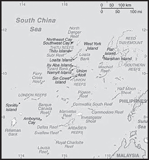
INTRODUCTION
Background: The Spratly Islands consist of more than 100 small islands or reefs surrounded by rich fishing grounds - and potentially by gas and oil deposits. They are claimed in their entirety by China, Taiwan, and Vietnam, while portions are claimed by Malaysia and the Philippines. About 45 islands are occupied by relatively small numbers of military forces from China, Malaysia, the Philippines, Taiwan, and Vietnam. Since 1985, Brunei has claimed a continental shelf that overlaps a southern reef but has not made any formal claim to the reef. Brunei claims an exclusive economic zone over this area.
GEOGRAPHY
Location: Southeastern Asia, group of reefs and islands in the South China Sea, about two-thirds of the way from southern Vietnam to the southern Philippines
Geographic coordinates: 8 38 N, 111 55 E
Map references: Southeast Asia
Area: total: 5 sq km less than
land: 5 sq km less than
water: 0 sq km
note: includes 100 or so islets, coral reefs, and sea mounts scattered over an area of nearly 410,000 sq km (158,000 sq mi) of the central South China Sea
comparison ranking: total 250
Area - comparative: land area is about seven times the size of the National Mall in Washington, DC
Land boundaries: total: 0 km
Coastline: 926 km
Maritime claims: NA
Climate: tropical
Terrain: small, flat islands, islets, cays, and reefs
Elevation: highest point: unnamed location on Southwest Cay 6 m
lowest point: South China Sea 0 m
Natural resources: fish, guano, undetermined oil and natural gas potential
Land use: other: 100% (2018 est.)
Natural hazards: typhoons; numerous reefs and shoals pose a serious maritime hazard
Geography - note: strategically located near several primary shipping lanes in the central South China Sea; includes numerous small islands, atolls, shoals, and coral reefs
PEOPLE AND SOCIETY
Population: (July 2021 est.) no indigenous inhabitants
note: there are scattered garrisons occupied by military personnel of several claimant states
ENVIRONMENT
Environment - current issues: China’s use of dredged sand and coral to build artificial islands harms reef systems; illegal fishing practices indiscriminately harvest endangered species, including sea turtles and giant clams
Climate: tropical
Land use: other: 100% (2018 est.)
GOVERNMENT
Country name: conventional long form: none
conventional short form: Spratly Islands
etymology: named after a British whaling captain Richard SPRATLY, who sighted Spratly Island in 1843; the name of the island eventually passed to the entire archipelago
TRANSPORTATION
Airports: 8 (2021)
comparison ranking: total 163
Airports - with paved runways: 7
note: paved runways have a concrete or asphalt surface but not all have facilities for refueling, maintenance, or air traffic control; the length of a runway required for aircraft to safely operate depends on a number of factors including the type of aircraft, the takeoff weight (including passengers, cargo, and fuel), engine types, flap settings, landing speed, elevation of the airport, and average maximum daily air temperature; paved runways can reach a length of 5,000 m (16,000 ft.), but the “typical” length of a commercial airline runway is between 2,500-4,000 m (8,000-13,000 ft.)
Airports - with unpaved runways: 2
note: unpaved runways have a surface composition such as grass or packed earth and are most suited to the operation of light aircraft; unpaved runways are usually short, often less than 1,000 m (3,280 ft.) in length; airports with unpaved runways often lack facilities for refueling, maintenance, or air traffic control
Heliports: 5 (2021)
Ports and terminals: none; offshore anchorage only
MILITARY AND SECURITY
Military - note: the Spratly Islands consist of more than 100 small islands or reefs of which about 45 are claimed and occupied by China, Malaysia, the Philippines, Taiwan, and Vietnam
China: occupies seven outposts (Fiery Cross, Mischief, Subi, Cuarteron, Gavin, Hughes, and Johnson reefs); the outposts on Fiery Cross, Mischief, and Subi include air bases with helipads and aircraft hangers, naval port facilities, surveillance radars, air defense and anti-ship missile sites, and other military infrastructure such as communications, barracks, maintenance facilities, and ammunition and fuel bunkers
Malaysia: occupies five outposts in the southern portion of the archipelago, closest to the Malaysian state of Sabah (Ardasier Reef, Eric Reef, Mariveles Reef, Shallow Reef, and Investigator Shoal); all the outposts have helicopter landing pads, while Shallow Reef also has an airstrip
Philippines: occupies nine features (Commodore Reef, Second Thomas Shoal, Flat Island, Loaita Cay, Loaita Island, Nanshan Island, Northeast Cay, Thitu Island, and West York Island); Thitu Island has the only Philippine airstrip in the Spratlys
Taiwan: maintains a coast guard outpost with an airstrip on Itu Aba Island
Vietnam: occupies about 50 outposts spread across 27 features, including facilities on 21 rocks and reefs in the Spratlys, plus 14 platforms known as “economic, scientific, and technological service stations,” or  (DK1), on six underwater banks to the southeast that Vietnam does not consider part of the disputed island chain, although China and Taiwan disagree; Spratly Islands outposts are on Alison Reef, Amboyna Cay, Barque Canada Reef, Central Reef, Collins Reef, Cornwallis South Reef, Discovery Great Reef, East Reef, Grierson Reef, Ladd Reef, Landsdowne Reef, Namyit Island, Pearson Reef, Petley Reef, Sand Cay, Sin Cowe Island, South Reef, Southwest Cay, Spratly Island, Tennent Reef, West Reef; Spratly Island includes an airstrip with aircraft hangers; the six underwater banks with outposts include Vanguard, Rifleman, Prince of Wales, Prince Consort, Grainger, and Alexandra; over the past few years, Vietnam has continued to make modest improvements to its outposts, including defensive positions and infrastructure (2023)
TRANSNATIONAL ISSUES
Disputes - international: Taiwan-Brunei-China-Malaysia-Philippines-Vietnam: all of the Spratly Islands are claimed by China (including Taiwan) and Vietnam; parts of them are claimed by Brunei, Malaysia and the Philippines; despite no public territorial claim to Louisa Reef, Brunei implicitly lays claim by including it within the natural prolongation of its continental shelf and basis for a seabed median with Vietnam; the islands are strategically located in the South China Sea and are surrounded by rich fishing groups and potential oil and natural gas deposits; claimants in November 2002 signed the “Declaration on the Conduct of Parties in the South China Sea,” which eased tensions but fell short of a legally binding “code of conduct”; in March 2005, the national oil companies of China, the Philippines, and Vietnam signed a joint accord to conduct marine seismic activities in the Spratly Islands; China’s island-building and military presence in the archipelago remain controversial
SRI LANKA
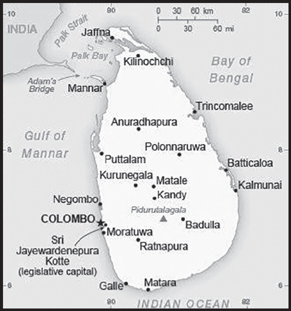
INTRODUCTION
Background: The first Sinhalese arrived in Sri Lanka late in the 6th century B.C., probably from northern India. Buddhism was introduced circa 250 B.C., and the first kingdoms developed at the cities of Anuradhapura (from circa 200 B.C. to circa A.D. 1000) and Polonnaruwa (from about 1070 to 1200). In the 14th century, a south Indian dynasty established a Tamil kingdom in northern Sri Lanka. The Portuguese controlled the coastal areas of the island in the 16th century followed by the Dutch in the 17th century. The island was ceded to the British in 1796, became a crown colony in 1802, and was formally united under British rule by 1815. As Ceylon, it became independent in 1948; its name was changed to Sri Lanka in 1972. Prevailing tensions between the Sinhalese majority and Tamil separatists erupted into war in July 1983. Fighting between the government and Liberation Tigers of Tamil Eelam (LTTE) continued for over a quarter century. Although Norway brokered peace negotiations that led to a cease-fire in 2002, the fighting slowly resumed and was again in full force by 2006. The government defeated the LTTE in May 2009.
During the post-conflict years under then-President Mahinda RAJAPAKSA, the government initiated infrastructure development projects, many of which were financed by loans from China. His regime faced significant allegations of human rights violations and a shrinking democratic space for civil society. In 2015, a new coalition government headed by then-President Maithripala SIRISENA of the Sri Lanka Freedom Party and then-Prime Minister Ranil WICKREMESINGHE of the United National Party came to power with pledges to advance economic, governance, anti-corruption, reconciliation, justice, and accountability reforms. However, implementation of these reforms was uneven. In November 2019, Gotabaya RAJAPAKSA won the presidential election and appointed his brother, Mahinda, prime minister. Following Gotabaya RAJAPAKSA’s election, civil society raised concerns about his administration’s commitment to pursuing justice, human rights, and accountability reforms, as well as the risks to foreign creditors that Sri Lanka faces given its ongoing economic crisis. A combination of factors including the impact of the worldwide COVID pandemic; severe shortages of food, medicine, and fuel; and power outages triggered increasingly violent protests in Columbo beginning in March 2022. In May 2022, longtime parliamentarian and former five-time prime minister, Ranil WICKREMESINGHE replaced Mahinda RAJAPASKA as prime-minister and then in July 2022, Gotabaya RAJAPAKSA fled from office in response to protests, and parliament subsequently elected WICKREMESINGHE president. Later that month, WICKREMESINGHE appointed Dinesh GUNAWARDENA to replace him as prime minister.
GEOGRAPHY
Location: Southern Asia, island in the Indian Ocean, south of India
Geographic coordinates: 7 00 N, 81 00 E
Map references: Asia
Area: total: 65,610 sq km
land: 64,630 sq km
water: 980 sq km
comparison ranking: total 122
Area - comparative: slightly larger than West Virginia
Land boundaries: total: 0 km
Coastline: 1,340 km
Maritime claims: territorial sea: 12 nm
contiguous zone: 24 nm
exclusive economic zone: 200 nm
continental shelf: 200 nm or to the edge of the continental margin
Climate: tropical monsoon; northeast monsoon (December to March); southwest monsoon (June to October)
Terrain: mostly low, flat to rolling plain; mountains in south-central interior
Elevation: highest point: Pidurutalagala 2,524 m
lowest point: Indian Ocean 0 m
mean elevation: 228 m
Natural resources: limestone, graphite, mineral sands, gems, phosphates, clay, hydropower, arable land
Land use: agricultural land: 43.5% (2018 est.)
arable land: 20.7% (2018 est.)
permanent crops: 15.8% (2018 est.)
permanent pasture: 7% (2018 est.)
forest: 29.4% (2018 est.)
other: 27.1% (2018 est.)
Irrigated land: 5,700 sq km (2012)
Population distribution: the population is primarily concentrated within a broad wet zone in the southwest, urban centers along the eastern coast, and on the Jaffna Peninsula in the north
Natural hazards: occasional cyclones and tornadoes
Geography - note: strategic location near major Indian Ocean sea lanes; Adam’s Bridge is a chain of limestone shoals between the southeastern coast of India and the northwestern coast of Sri Lanka; geological evidence suggests that this 50-km long Bridge once connected India and Sri Lanka; ancient records seem to indicate that a foot passage was possible between the two land masses until the 15th century when the land bridge broke up in a cyclone
PEOPLE AND SOCIETY
Population: 23,326,272 (2023 est.)
comparison ranking: 58
Nationality: noun: Sri Lankan(s)
adjective: Sri Lankan
Ethnic groups: Sinhalese 74.9%, Sri Lankan Tamil 11.2%, Sri Lankan Moors 9.2%, Indian Tamil 4.2%, other 0.5% (2012 est.)
Languages: Sinhala (official and national language) 87%, Tamil (official and national language) 28.5%, English 23.8% (2012 est.)
note: data represent main languages spoken by the population aged 10 years and older; shares sum to more than 100% because some respondents gave more than one answer on the census; English is commonly used in government and is referred to as the “link language” in the constitution
Religions: Buddhist (official) 70.2%, Hindu 12.6%, Muslim 9.7%, Roman Catholic 6.1%, other Christian 1.3%, other 0.05% (2012 est.)
Age structure: 0-14 years: 21.95% (male 2,609,642/female 2,511,570)
15-64 years: 66.22% (male 7,609,573/female 7,836,480)
65 years and over: 11.83% (2023 est.) (male 1,156,637/female 1,602,370)
Dependency ratios: total dependency ratio: 53.7
youth dependency ratio: 35.4
elderly dependency ratio: 17
potential support ratio: 5.9 (2021 est.)
Median age: total: 33.9 years (2023 est.)
male: 32.1 years
female: 35.6 years
comparison ranking: total 104
Population growth rate: 0.56% (2023 est.)
comparison ranking: 148
Birth rate: 14.6 births/1,000 population (2023 est.)
comparison ranking: 118
Death rate: 7.4 deaths/1,000 population (2023 est.)
comparison ranking: 109
Net migration rate: -1.5 migrant(s)/1,000 population (2023 est.)
comparison ranking: 158
Population distribution: the population is primarily concentrated within a broad wet zone in the southwest, urban centers along the eastern coast, and on the Jaffna Peninsula in the north
Urbanization: urban population: 19.2% of total population (2023)
rate of urbanization: 1.22% annual rate of change (2020-25 est.)
Major urban areas - population: 103,000 Sri Jayewardenepura Kotte (legislative capital) (2018), 633,000 COLOMBO (capital) (2023)
Sex ratio: at birth: 1.05 male(s)/female
0-14 years: 1.04 male(s)/female
15-64 years: 0.97 male(s)/female
65 years and over: 0.72 male(s)/female
total population: 0.94 male(s)/female (2023 est.)
Mother’s mean age at first birth: 25.6 years (2016 est.)
note: data represents median age at first birth among women 30-34
Maternal mortality ratio: 29 deaths/100,000 live births (2020 est.)
comparison ranking: 112
Infant mortality rate: total: 6.8 deaths/1,000 live births (2023 est.)
male: 7.5 deaths/1,000 live births
female: 6.1 deaths/1,000 live births
comparison ranking: total 159
Life expectancy at birth: total population: 76.6 years (2023 est.)
male: 73.6 years
female: 79.8 years
comparison ranking: total population 99
Total fertility rate: 2.14 children born/woman (2023 est.)
comparison ranking: 92
Gross reproduction rate: 1.05 (2023 est.)
Contraceptive prevalence rate: 64.6% (2016)
Drinking water source: improved: urban: 99.7% of population
rural: 91.2% of population
total: 92.8% of population
unimproved: urban: 0.3% of population
rural: 8.8% of population
total: 7.2% of population (2020 est.)
Current health expenditure: 4.1% of GDP (2020)
Physicians density: 1.23 physicians/1,000 population (2020)
Hospital bed density: 4.2 beds/1,000 population (2017)
Sanitation facility access: improved: urban: 96.6% of population
rural: 97.9% of population
total: 97.6% of population
unimproved: urban: 3.4% of population
rural: 2.1% of population
total: 2.4% of population (2020 est.)
Major infectious diseases: degree of risk: intermediate (2023)
vectorborne diseases: dengue fever
water contact diseases: leptospirosis
animal contact diseases: rabies
Obesity - adult prevalence rate: 5.2% (2016)
comparison ranking: 182
Alcohol consumption per capita: total: 2.58 liters of pure alcohol (2019 est.)
beer: 0.22 liters of pure alcohol (2019 est.)
wine: 0.01 liters of pure alcohol (2019 est.)
spirits: 2.32 liters of pure alcohol (2019 est.)
other alcohols: 0.03 liters of pure alcohol (2019 est.)
comparison ranking: total 122
Tobacco use: total: 22% (2020 est.)
male: 41.4% (2020 est.)
female: 2.6% (2020 est.)
comparison ranking: total 72
Children under the age of 5 years underweight: 20.5% (2016)
comparison ranking: 16
Currently married women (ages 15-49): 65.1% (2023 est.)
Child marriage: women married by age 15: 0.9%
women married by age 18: 9.8% (2016 est.)
Education expenditures: 1.9% of GDP (2019 est.)
comparison ranking: 187
Literacy: definition: age 15 and over can read and write
total population: 92.3%
male: 93%
female: 91.6% (2019)
School life expectancy (primary to tertiary education): total: 14 years
male: 14 years
female: 14 years (2018)
Youth unemployment rate (ages 15-24): total: 26.1% (2021 est.)
male: 21.1%
female: 35.6%
comparison ranking: total 57
ENVIRONMENT
Environment - current issues: deforestation; soil erosion; wildlife populations threatened by poaching and urbanization; coastal degradation from mining activities and increased pollution; coral reef destruction; freshwater resources being polluted by industrial wastes and sewage runoff; waste disposal; air pollution in Colombo
Environment - international agreements: party to: Biodiversity, Climate Change, Climate Change-Kyoto Protocol, Climate Change-Paris Agreement, Desertification, Endangered Species, Environmental Modification, Hazardous Wastes, Law of the Sea, Nuclear Test Ban, Ozone Layer Protection, Ship Pollution, Wetlands
signed, but not ratified: Comprehensive Nuclear Test Ban, Marine Life Conservation
Climate: tropical monsoon; northeast monsoon (December to March); southwest monsoon (June to October)
Land use: agricultural land: 43.5% (2018 est.)
arable land: 20.7% (2018 est.)
permanent crops: 15.8% (2018 est.)
permanent pasture: 7% (2018 est.)
forest: 29.4% (2018 est.)
other: 27.1% (2018 est.)
Urbanization: urban population: 19.2% of total population (2023)
rate of urbanization: 1.22% annual rate of change (2020-25 est.)
Food insecurity: widespread lack of access: due to serious macroeconomic challenges, significant reduction in 2022 cereal output, and high food prices - severe macroeconomic challenges, mostly reflecting dwindling foreign currency reserves after revenues from merchandise exports, remittances, and from the tourist sector declined dramatically over the last year, have had a negative impact on the country’s capacity to import cereals; the 2022 cereal production sharply declined due to a government ordered reduction in the application of chemical fertilizers; unprecedentedly high food prices are constraining economic access to food for a majority of households
Revenue from forest resources: 0.06% of GDP (2018 est.)
comparison ranking: 126
Revenue from coal: 0% of GDP (2018 est.)
comparison ranking: 178
Air pollutants: particulate matter emissions: 23.88 micrograms per cubic meter (2019 est.)
carbon dioxide emissions: 23.36 megatons (2016 est.)
methane emissions: 10.95 megatons (2020 est.)
Waste and recycling: municipal solid waste generated annually: 2,631,650 tons (2016 est.)
municipal solid waste recycled annually: 336,588 tons (2016 est.)
percent of municipal solid waste recycled: 12.8% (2016 est.)
Total water withdrawal: municipal: 810 million cubic meters (2020 est.)
industrial: 830 million cubic meters (2020 est.)
agricultural: 11.31 billion cubic meters (2020 est.)
Total renewable water resources: 52.8 billion cubic meters (2020 est.)
GOVERNMENT
Country name: conventional long form: Democratic Socialist Republic of Sri Lanka
conventional short form: Sri Lanka
local long form: Shri Lanka Prajatantrika Samajavadi Janarajaya (Sinhala)/ Ilankai Jananayaka Choshalichak Kutiyarachu (Tamil)
local short form: Shri Lanka (Sinhala)/ Ilankai (Tamil)
former: Serendib, Ceylon
etymology: the name means “resplendent island” in Sanskrit
Government type: presidential republic
Capital: name: Colombo (commercial capital); Sri Jayewardenepura Kotte (legislative capital)
geographic coordinates: 6 55 N, 79 50 E
time difference: UTC+5.5 (10.5 hours ahead of Washington, DC, during Standard Time)
etymology: Colombo may derive from the Sinhala “kolon thota,” meaning “port on the river” (referring to the Kelani River that empties into the Indian Ocean at Colombo); alternatively, the name may derive from the Sinhala “kola amba thota” meaning “harbor with mango trees”; it is also possible that the Portuguese named the city after Christopher COLUMBUS, who lived in Portugal for many years (as Cristovao COLOMBO) before discovering the Americas for the Spanish crown in 1492 - not long before the Portuguese made their way to Sri Lanka in 1505; Sri Jayewardenepura Kotte translates as “Resplendent City of Growing Victory” in Sinhala
Administrative divisions: 9 provinces; Central, Eastern, North Central, Northern, North Western, Sabaragamuwa, Southern, Uva, Western
Independence: 4 February 1948 (from the UK)
National holiday: Independence Day (National Day), 4 February (1948)
Constitution: history: several previous; latest adopted 16 August 1978, certified 31 August 1978
amendments: proposed by Parliament; passage requires at least two-thirds majority vote of its total membership, certification by the president of the republic or the Parliament speaker, and in some cases approval in a referendum by absolute majority of valid votes; amended many times, last in 2020
Legal system: mixed legal system of Roman-Dutch civil law, English common law, Jaffna Tamil customary law, and Muslim personal law
International law organization participation: has not submitted an ICJ jurisdiction declaration; non-party state to the ICCt
Citizenship: citizenship by birth: no
citizenship by descent only: at least one parent must be a citizen of Sri Lanka
dual citizenship recognized: no, except in cases where the government rules it is to the benefit of Sri Lanka
residency requirement for naturalization: 7 years
Suffrage: 18 years of age; universal
Executive branch: chief of state: President Ranil WICKREMESINGHE (since 20 July 2022); the president is both chief of state and head of government; Prime Minister Dinesh GUNAWARDENA (since 22 July 2022)
head of government: President Ranil WICKREMESINGHE (since 20 July 2022)
cabinet: Cabinet appointed by the president in consultation with the prime minister
elections/appointments: president directly elected by preferential majority popular vote for a 5-year term (eligible for a second term); election last held on 16 November 2019 (next to be held in 2024); prime minister appointed by the president from among members of Parliament for a 5-year term)
election results: Ranil WICKREMESINGHE elected president by Parliament on 20 July 2022; Parliament vote - WICKREMESINGHE (UNP) 134, Dullas ALAHAPPERUNA (SLPP) 82
Note: amid public protests which began in March 2022, President Gotabaya RAJAPAKSE fled the country on 13 July and Ranil WICKREMESINGHE became acting president; RAJAPAKSE announced his resignation on the 14th, which was accepted by the speaker of Parliament the following day
Legislative branch: description: unicameral Parliament (225 seats; 196 members directly elected in multi-seat district constituencies by proportional representation vote using a preferential method in which voters select 3 candidates in order of preference; remaining 29 seats, referred to as the “national list” are allocated by each party secretary according to the island wide proportional vote the party obtains; members serve 5-year terms)
elections: last held on 5 August 2020 (next to be held in August 2025)
election results: percent of vote by coalition/party - SLFPA 59.1%, SJB 23.9%, JVP 3.8%, TNA 2.8%, UNP 2.2%, TNPF 0.6%, EPDP 0.5%, other 7.1%; seats by coalition/party - SLFPA 145, SJB 54, TNA 10, JVP 3, other 13; composition - men 213, women 12, percent of women 5.3%
Judicial branch: highest court(s): Supreme Court of the Republic (consists of the chief justice and 9 justices); note - the court has exclusive jurisdiction to review legislation
judge selection and term of office: chief justice nominated by the Constitutional Council (CC), a 9-member high-level advisory body, and appointed by the president; other justices nominated by the CC and appointed by the president on the advice of the chief justice; all justices can serve until age 65
subordinate courts: Court of Appeals; High Courts; Magistrates’ Courts; municipal and primary courts
Political parties and leaders: Crusaders for Democracy or CFD [Ganeshalingam CHANDRALINGAM]
Eelam People’s Democratic Party or EPDP [Douglas DEVANANDA]
Eelam People’s Revolutionary Liberation Front or EPRLF [Suresh PREMACHANDRAN]
Illankai Tamil Arasu Kachchi or ITAK [Mavai SENATHIRAJAH]
Janatha Vimukthi Peramuna or JVP [Anura Kumara DISSANAYAKE]
Jathika Hela Urumaya or JHU [Udaya GAMMANPILA]
National People’s Power or NPP (also known as Jathika Jana Balawegaya or JJB) [Anura Kumara DISSANAYAKE]
People’s Liberation Organisation of Tamil Eelam or PLOTE [Dharmalingam SIDDARTHAN]
Samagi Jana Balawegaya or SJB [Sajith PREMADASA]
Sri Lanka Freedom Party or SLFP [Maithripala SIRISENA]
Sri Lanka Muslim Congress or SLMC [Rauff HAKEEM]
Sri Lanka People’s Freedom Alliance or SLPFA [Mahinda RAJAPAKSA] (includes SLPFP, SLPP, and several smaller parties)
Sri Lanka Podujana Peramuna (Sri Lanka’s People’s Front) or SLPP [Gamini Lakshman PEIRIS]
Tamil Eelam Liberation Organization or TELO [Selvam ADAIKALANATHAN]
Tamil National Alliance or TNA [Rajavarothiam SAMPANTHAN] (includes ITAK, PLOTE, TELO)
Tamil National People’s Front or TNPF [Gajendrakumar PONNAMBALAM]
Tamil People’s National Alliance or TPNA [Canagasabapathy Visuvalingam VIGNESWARAN]
United National Front for Good Governance or UNFGG [Ranil WICKREMESINGHE] (coalition includes JHU, UNP)
United National Party or UNP [Ranil WICKREMESINGHE]
International organization participation: ABEDA, ADB, ARF, BIMSTEC, C, CD, CICA (observer), CP, FAO, G-11, G-15, G-24, G-77, IAEA, IBRD, ICAO, ICC (national committees), ICRM, IDA, IFAD, IFC, IFRCS, IHO, ILO, IMF, IMO, IMSO, Interpol, IOC, IOM, IPU, ISO, ITSO, ITU, ITUC (NGOs), MIGA, MINURSO, MINUSTAH, MONUSCO, NAM, OAS (observer), OPCW, PCA, SAARC, SACEP, SCO (dialogue member), UN, UNCTAD, UNESCO, UNIDO, UNIFIL, UNISFA, UNMISS, UNWTO, UPU, WCO, WFTU (NGOs), WHO, WIPO, WMO, WTO
Diplomatic representation in the US: chief of mission: Ambassador Mahinda SAMARASINGHE (since 13 January 2022)
chancery: 3025 Whitehaven Street NW, Washington, DC 20008
telephone: [1] (202) 483-4025
FAX: [1] (202) 232-7181
email address and website:
consulate(s) general: Los Angeles, New York
Diplomatic representation from the US: chief of mission: Ambassador Julie J. CHUNG (since 17 February 2022)
embassy: 210 Galle Road, Colombo 03
mailing address: 6100 Colombo Place, Washington DC 20521-6100
telephone: [94] (11) 249-8500
FAX: [94] (11) 243-7345
email address and website:
Flag description: yellow with two panels; the smaller hoist-side panel has two equal vertical bands of green (hoist side) and orange; the other larger panel depicts a yellow lion holding a sword on a maroon rectangular field that also displays a yellow bo leaf in each corner; the yellow field appears as a border around the entire flag and extends between the two panels; the lion represents Sinhalese ethnicity, the strength of the nation, and bravery; the sword demonstrates the sovereignty of the nation; the four bo leaves - symbolizing Buddhism and its influence on the country - stand for the four virtues of kindness, friendliness, happiness, and equanimity; orange signifies Sri Lankan Tamils, green Sri Lankan Moors, and maroon the Sinhalese majority; yellow denotes other ethnic groups; also referred to as the Lion Flag
National symbol(s): lion, water lily; national colors: maroon, yellow
National anthem: name: “Sri Lanka Matha” (Mother Sri Lanka)
lyrics/music: Ananda SAMARKONE
note: adopted 1951
National heritage: total World Heritage Sites: 8 (6 cultural, 2 natural)
selected World Heritage Site locales: Ancient City of Polonnaruwa (c); Ancient City of Sigiriya (c); Sacred City of Anuradhapura (c); Old Town of Galle and its Fortifications (c); Sacred City of Kandy (c); Sinharaja Forest Reserve (n); Rangiri Dambulla Cave Temple (c); Central Highlands of Sri Lanka (n)
ECONOMY
Economic overview: lower middle-income South Asian island economy; extremely high public debts; rapid inflation; facing domestic food, fuel, and medicine shortages; tourism industry disrupted by COVID-19; known garment and commodities exporter; low foreign exchange reserves
Real GDP (purchasing power parity): $296.595 billion (2021 est.)
$287.046 billion (2020 est.)
$297.372 billion (2019 est.)
note: data are in 2017 dollars
comparison ranking: 57
Real GDP growth rate: 3.33% (2021 est.)
-3.47% (2020 est.)
-0.22% (2019 est.)
comparison ranking: 137
Real GDP per capita: $13,400 (2021 est.)
$13,100 (2020 est.)
$13,600 (2019 est.)
note: data are in 2017 dollars
comparison ranking: 123
GDP (official exchange rate): $84.016 billion (2019 est.)
Inflation rate (consumer prices): 7.01% (2021 est.)
6.15% (2020 est.)
3.53% (2019 est.)
comparison ranking: 46
Credit ratings: Fitch rating: CCC (2020)
Moody’s rating: Caa1 (2020)
Standard & Poors rating: CCC+ (2020)
note: The year refers to the year in which the current credit rating was first obtained.
GDP - composition, by sector of origin: agriculture: 7.8% (2017 est.)
industry: 30.5% (2017 est.)
services: 61.7% (2017 est.)
comparison rankings: services 109; industry 75; agriculture 102
GDP - composition, by end use: household consumption: 62% (2017 est.)
government consumption: 8.5% (2017 est.)
investment in fixed capital: 26.3% (2017 est.)
investment in inventories: 10.2% (2017 est.)
exports of goods and services: 21.9% (2017 est.)
imports of goods and services: -29.1% (2017 est.)
Agricultural products: rice, coconuts, sugar cane, plantains, milk, tea, cassava, maize, poultry, coir
Industries: processing of rubber, tea, coconuts, tobacco and other agricultural commodities; telecommunications, insurance, banking; tourism, shipping; clothing, textiles; cement, petroleum refining, information technology services, construction
Industrial production growth rate: 5.62% (2021 est.)
comparison ranking: 81
Labor force: 8.268 million (2021 est.)
comparison ranking: 64
Labor force - by occupation: agriculture: 27%
industry: 26%
services: 47% (31 December 2016)
Unemployment rate: 5.39% (2021 est.)
5.88% (2020 est.)
4.35% (2019 est.)
comparison ranking: 138
Youth unemployment rate (ages 15-24): total: 26.1% (2021 est.)
male: 21.1%
female: 35.6%
comparison ranking: total 57
Population below poverty line: 4.1% (2016 est.)
Gini Index coefficient - distribution of family income: 39.3 (2016 est.)
comparison ranking: 60
Average household expenditures: on food: 28% of household expenditures (2018 est.)
on alcohol and tobacco: 2% of household expenditures (2018 est.)
Household income or consumption by percentage share: lowest 10%: 3%
highest 10%: 32.2% (2012 est.)
Budget: revenues: $10.623 billion (2019 est.)
expenditures: $17.496 billion (2019 est.)
Budget surplus (+) or deficit (-): -5.5% (of GDP) (2017 est.)
comparison ranking: 174
Public debt: 79.1% of GDP (2017 est.)
79.6% of GDP (2016 est.)
note: covers central government debt and excludes debt instruments directly owned by government entities other than the treasury (e.g. commercial bank borrowings of a government corporation); the data includes treasury debt held by foreign entities as well as intragovernmental debt; intragovernmental debt consists of treasury borrowings from surpluses in the social funds, such as for retirement; sub-national entities are usually not permitted to sell debt instruments
comparison ranking: 43
Taxes and other revenues: 7.68% (of GDP) (2020 est.)
comparison ranking: 211
Fiscal year: calendar year
Current account balance: -$1.083 billion (2020 est.)
-$1.843 billion (2019 est.)
-$2.799 billion (2018 est.)
comparison ranking: 137
Exports: $13.083 billion (2020 est.) note: data are in current year dollars
$19.414 billion (2019 est.) note: data are in current year dollars
$20.264 billion (2018 est.)
comparison ranking: 95
Exports - partners: United States 24%, India 8%, United Kingdom 7%, Germany 7% (2019)
Exports - commodities: clothing and apparel, tea, used tires, rubber products, precious stones, cinnamon (2019)
Imports: $18.271 billion (2020 est.) note: data are in current year dollars
$24.562 billion (2019 est.) note: data are in current year dollars
$26.841 billion (2018 est.)
comparison ranking: 94
Imports - partners: India 24%, China 23%, Singapore 7%, United Arab Emirates 6%, Malaysia 5% (2019)
Imports - commodities: refined petroleum, textiles, gold, cars, broadcasting equipment (2019)
Reserves of foreign exchange and gold: $3.137 billion (31 December 2021 est.)
$5.664 billion (31 December 2020 est.)
$7.648 billion (31 December 2019 est.)
comparison ranking: 117
Debt - external: $55.332 billion (2019 est.)
$52.567 billion (2018 est.)
comparison ranking: 64
Exchange rates: Sri Lankan rupees (LKR) per US dollar -
Exchange rates:
198.764 (2021 est.)
185.593 (2020 est.)
178.745 (2019 est.)
162.465 (2018 est.)
152.446 (2017 est.)
ENERGY
Electricity access: electrification - total population: 100% (2021)
Electricity: installed generating capacity: 4.527 million kW (2020 est.)
consumption: 13,991,420,000 kWh (2019 est.)
exports: 0 kWh (2020 est.)
imports: 0 kWh (2020 est.)
transmission/distribution losses: 1.337 billion kWh (2019 est.)
comparison rankings: imports 212; exports 212; installed generating capacity 93; transmission/distribution losses 100; consumption 83
Electricity generation sources: fossil fuels: 64% of total installed capacity (2020 est.)
solar: 0.7% of total installed capacity (2020 est.)
wind: 2.3% of total installed capacity (2020 est.)
hydroelectricity: 32.2% of total installed capacity (2020 est.)
Coal: production: 0 metric tons (2020 est.)
consumption: 2.237 million metric tons (2020 est.)
exports: 0 metric tons (2020 est.)
imports: 2.586 million metric tons (2020 est.)
proven reserves: 0 metric tons (2019 est.)
Petroleum: total petroleum production: 0 bbl/day (2021 est.)
refined petroleum consumption: 131,100 bbl/day (2019 est.)
crude oil and lease condensate exports: 0 bbl/day (2018 est.)
crude oil and lease condensate imports: 35,300 bbl/day (2018 est.)
crude oil estimated reserves: 0 barrels (2021 est.)
Refined petroleum products - production: 34,210 bbl/day (2017 est.)
comparison ranking: 84
Refined petroleum products - exports: 3,871 bbl/day (2015 est.)
comparison ranking: 96
Refined petroleum products - imports: 66,280 bbl/day (2015 est.)
comparison ranking: 70
Carbon dioxide emissions: 23.939 million metric tonnes of CO2 (2019 est.)
from coal and metallurgical coke: 5.546 million metric tonnes of CO2 (2019 est.)
from petroleum and other liquids: 18.393 million metric tonnes of CO2 (2019 est.)
comparison ranking: total emissions 80
Energy consumption per capita: 17.268 million Btu/person (2019 est.)
comparison ranking: 138
COMMUNICATIONS
Telephones - fixed lines: total subscriptions: 2,869,186 (2021 est.)
subscriptions per 100 inhabitants: 13 (2021 est.)
comparison ranking: total subscriptions 45
Telephones - mobile cellular: total subscriptions: 30,764,134 (2021 est.)
subscriptions per 100 inhabitants: 141 (2021 est.)
comparison ranking: total subscriptions 45
Telecommunication systems: general assessment: Sri Lanka’s fixed-line telephony market was one of the very few in the world to experience a significant upsurge in subscriptions in 2020; while the country suffers from a relatively poor fixed-line infrastructure and a correspondingly strong mobile sector, demand for traditional phone services increased 14% in 2020; preliminary results suggest a further jump of up to 13% can also be expected in 2021; this will take Sri Lanka’s fixed-line penetration to levels not seen since 2013; the most reason behind the market’s reversal of fortunes is the Covid-19 crisis and Sri Lanka’s ensuring lock downs; these forced much of the population back inside and reverting to ‘traditional’ methods of communication for both voice and data services; the fixed broadband market was equally robust, growing 20% in 2020 alone; Sri Lanka possesses a relatively low number of computers per household so the fixed broadband market’s success comes off a small base; the one area of the telecommunications market that experienced a fall was the mobile segment; up until the start of the pandemic, Sri Lanka had a very high mobile penetration rate of 155%; this nearsaturation level reflected the preponderance for subscribers to carry multiple SIM cards to take advantage of cheaper on-net call rates; the reduction in demand and traffic because of the pandemic led to a sharp drop in the number of active subscriptions, down to just 135% – a 17% decline in just one year; the market is expected to bounce back quickly, as soon as the country eases back on its lock down measures and reduces travel restrictions; it will also be boosted, come 2022, by the anticipated launch of commercial 5G mobile services (2021)
domestic: fixed-line is 13 per 100 and mobile-cellular is 141 per 100 (2021)
international: country code - 94; landing points for the SeaMeWe -3,-5, Dhiraagu-SLT Submarine Cable Network, WARF Submarine Cable, Bharat Lanka Cable System and the Bay of Bengal Gateway submarine cables providing connectivity to Asia, Africa, Southeast Asia, Australia, the Middle East, and Europe; satellite earth stations - 2 Intelsat (Indian Ocean) (2019)
Broadcast media: government operates 5 TV channels and 19 radio channels; multi-channel satellite and cable TV subscription services available; 25 private TV stations and about 43 radio stations; 6 non-profit TV stations and 4 radio stations
Internet country code: .lk
Internet users: total: 14.74 million (2021 est.)
percent of population: 67% (2021 est.)
comparison ranking: total 51
Broadband - fixed subscriptions: total: 1,781,530 (2020 est.)
subscriptions per 100 inhabitants: 8 (2020 est.)
comparison ranking: total 60
TRANSPORTATION
National air transport system: number of registered air carriers: 3 (2020)
inventory of registered aircraft operated by air carriers: 34
annual passenger traffic on registered air carriers: 5,882,376 (2018)
annual freight traffic on registered air carriers: 436.2 million (2018) mt-km
Civil aircraft registration country code prefix: 4R
Airports: 18 (2021)
comparison ranking: total 139
Airports - with paved runways: 11
note: paved runways have a concrete or asphalt surface but not all have facilities for refueling, maintenance, or air traffic control; the length of a runway required for aircraft to safely operate depends on a number of factors including the type of aircraft, the takeoff weight (including passengers, cargo, and fuel), engine types, flap settings, landing speed, elevation of the airport, and average maximum daily air temperature; paved runways can reach a length of 5,000 m (16,000 ft.), but the “typical” length of a commercial airline runway is between 2,500-4,000 m (8,000-13,000 ft.)
Airports - with unpaved runways: 7
note: unpaved runways have a surface composition such as grass or packed earth and are most suited to the operation of light aircraft; unpaved runways are usually short, often less than 1,000 m (3,280 ft.) in length; airports with unpaved runways often lack facilities for refueling, maintenance, or air traffic control
Heliports: 1 (2021)
Pipelines: 7 km refined products
Railways: total: 1,562 km (2016)
broad gauge: 1,562 km (2016) 1.676-m gauge
comparison ranking: total 81
Roadways: total: 114,093 km (2010)
paved: 16,977 km (2010)
unpaved: 97,116 km (2010)
comparison ranking: total 43
Waterways: 160 km (2012) (primarily on rivers in southwest)
comparison ranking: 110
Merchant marine: total: 92 (2022)
by type: bulk carrier 5, general cargo 13, oil tanker 11, other 63
comparison ranking: total 95
Ports and terminals: major seaport(s): Colombo
container port(s) (TEUs): Colombo (7,250,000) (2021)
MILITARY AND SECURITY
Military and security forces: Sri Lanka Armed Forces: Sri Lanka Army (includes National Guard and the Volunteer Force), Sri Lanka Navy (includes Marine Corps), Sri Lanka Air Force, Sri Lanka Coast Guard; Civil Security Department (Home Guard)
Ministry of Public Security: Sri Lanka National Police (2023)
note 1: the Civil Security Department, also known as the Civil Defense Force, is an auxiliary force administered by the Ministry of Defense
note 2: the Sri Lanka Police includes the Special Task Force, a paramilitary unit responsible for counterterrorism and counterinsurgency operations; it coordinates internal security operations with the military
Military expenditures: 1.7% of GDP (2022 est.)
1.9% of GDP (2021 est.)
2% of GDP (2020 est.)
2% of GDP (2019 est.)
1.9% of GDP (2018 est.)
comparison ranking: 76
Military and security service personnel strengths: approximately 260,000 total personnel (200,000 Army; 30,000 Navy; 30,000 Air Force); approximately 11,000 Special Task Force personnel (2023)
note: in January 2023, Sri Lanka’s Ministry of Defense announced plans to decrease the size of the Army to 135,000 by 2024 and 100,000 by 2030
Military equipment inventories and acquisitions: the military’s inventory consists mostly of Chinese and Russian-origin equipment with a smaller mix of material from countries such as India and the US (2023)
Military service age and obligation: 18-22 years of age for voluntary military service for men and women; no conscription (2023)
Military deployments: 100 Central African Republic (MINUSCA); 125 Lebanon (UNIFIL); 240 Mali (MINUSMA) (2023)
Military - note: the military is responsible for external defense and may be called upon to handle specifically delineated domestic security responsibilities that generally do not include arrest authority; it has sent small numbers of personnel on UN peacekeeping missions; from 1983 to 2009, it fought against the Liberation Tigers of Tamil Eelam (LTTE), a conflict that involved both guerrilla and conventional warfare, as well as acts of terrorism and human rights abuses, and cost the military nearly 30,000 killed; since the end of the war, a large portion of the Army reportedly remains deployed in the majority Tamil-populated northern and eastern provinces; the military over the past decade also has increased its role in a range of commercial sectors including agriculture, hotels, leisure, and restaurants
the Army did not downsize following the LTTE war and continues to have about 20 infantry divisions, plus several independent brigades and regiments; however, in 2023 the Sri Lankan Government announced that because of the country’s financial crisis, it would slash the size of the Army 40% by 2024 with deeper cuts planned by 2030; the Navy has a frigate transferred from China in 2019 and several offshore patrol ships acquired from India and the US to patrol its territorial waters; it also has a large force of small in-shore patrol and fast attack boats, largely acquired to combat the LTTE; the Air Force is small and much of its inventory is aging; it has a handful of operational fighter aircraft and a few dozen attack and multi-role helicopters
Sri Lanka traditionally has had close security ties to India; India participated in the LTTE war in 1987-1991 and lost over 1,000 soldiers; the Sri Lankan and Indian militaries continue to conduct exercises together, and India trains over 1,000 Sri Lankan soldiers per year; in recent years, Sri Lanka has increased military ties with China, including acquiring military equipment, hosting naval port calls, and sending personnel to China for training (2023)
SPACE
Space agency/agencies: Sri Lanka Aeronautics and Space Agency (SLASA; established 2019); Space Applications Division of the Arthur C. Clarke Institute for Modern Technologies (ACCIMT; created 1984) (2023)
Space program overview: has a small space program focused on acquiring satellites and conducting research and development in space-related technologies, such as electronics, telecommunications, information technology, and robotics; has cooperated with the space agencies or industries of China, France, India, Japan, and the US (2023)
note: further details about the key activities, programs, and milestones of the country’s space program, as well as government spending estimates on the space sector, appear in Appendix S
TERRORISM
Terrorist group(s): Terrorist group(s): Islamic State of Iraq and ash-Sham (ISIS); Liberation Tigers of Tamil Eelam (LTTE)
note: details about the history, aims, leadership, organization, areas of operation, tactics, targets, weapons, size, and sources of support of the group(s) appear(s) in Appendix-T
TRANSNATIONAL ISSUES
Disputes - international: none identified
Refugees and internally displaced persons: IDPs: 12,000 (civil war; more than half displaced prior to 2008; many of the more than 480,000 IDPs registered as returnees have not reached durable solutions) (2022)
stateless persons: 35 (2022)
SUDAN
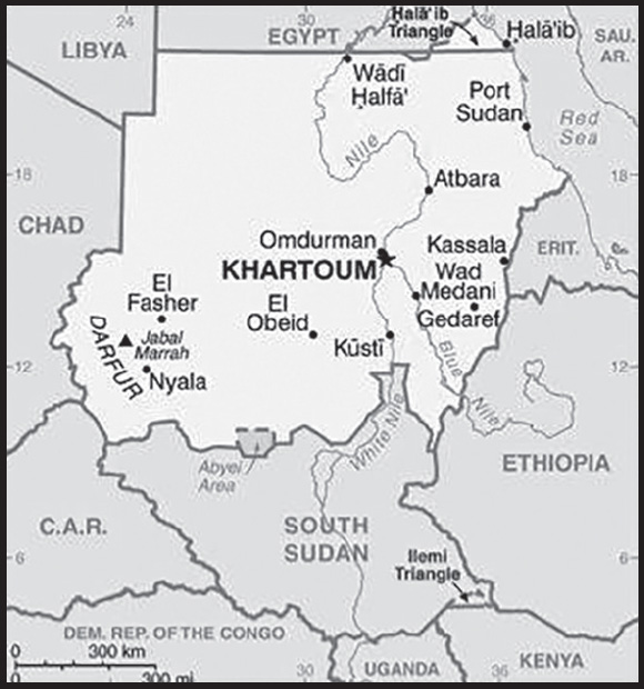
INTRODUCTION
Background: Long referred to as Nubia, modern-day Sudan was the site of the Kingdom of Kerma (ca. 2500-1500 B.C.) until it was absorbed into the New Kingdom of Egypt. By the 11th century B.C., the Kingdom of Kush gained independence from Egypt; it lasted in various forms until the middle of the 4th century A.D. After the fall of Kush, the Nubians formed three Christian kingdoms of Nobatia, Makuria, and Alodia. The latter two endured until around 1500. Between the 14th and 15th centuries much of Sudan was settled by Arab nomads, and between the 16th–19th centuries it underwent extensive Islamization. Following Egyptian occupation early in the 19th century, the British established an Anglo-Egyptian Sudan - nominally a condominium, but in effect a British colony.
Military regimes favoring Islamic-oriented governments have dominated national politics since Sudan gained independence from Anglo-Egyptian co-rule in 1956. The 30-year reign of President Omar Hassan Ahmad al-BASHIR, following months of nationwide protests, ended with the military forcing him out in April 2019. In July 2019, the country’s Transitional Military Council signed an agreement with the Forces for Freedom and Change (an umbrella group of civilian actors) to form a transitional government under a Constitutional Declaration. Economist and former international civil servant Abdalla HAMDOUK al-Kinani was selected to serve as prime minister of a transitional government, which was to have guided the country to credible democratic elections in late 2022. In October 2021, the Sudanese military organized a takeover that ousted Prime Minister HAMDOUK and his government and replaced civilian members of the Sovereign Council (Sudan’s collective Head of State) with individuals selected by the military. HAMDOUK was briefly reinstated in November 2021 but resigned in January 2022.
As of June 2023, General Abd-al-Fatah al-BURHAN Abd-al-Rahman, the Chair of Sudan’s Sovereign Council and Commander-in-Chief of the Sudanese Armed Forces, serves as de facto head of state and government. He presides over a Sovereign Council consisting of military leaders, former armed opposition group representatives, and civilians appointed by the military. A cabinet of acting ministers handles day-to-day administration. These acting ministers are either senior civil servants (some appointed by former Prime Minister HAMDOUK and some selected by the military) or holdover ministers from Prime Minister HAMDOUK’s former cabinet who were appointed by former armed opposition groups that the military allowed to remain in their positions. The Sudanese Armed Forces have been embroiled in a fight with the paramilitary Rapid Support Forces since mid-April 2023.
During most of the second half of the 20th century, Sudan was embroiled in two prolonged civil wars rooted in northern economic, political, and social domination of the largely non-Muslim, non-Arab southern portion of the country. The first civil war ended in 1972, but another broke out in 1983. Peace talks gained momentum in 2002-04, and the final North/South Comprehensive Peace Agreement (CPA), signed in January 2005, granted the southern rebels autonomy for six years followed by a referendum on independence for Southern Sudan. South Sudan became independent in July 2011, but Sudan and South Sudan have yet to fully implement security and economic agreements relating to the normalization of relations between the two countries.
In the 21st century, Sudan faced conflict in Darfur, Southern Kordofan, and Blue Nile starting in 2003, and between the Sudanese Armed Forces and the Rapid Support Forces in 2023, sparking mass displacement.
GEOGRAPHY
Location: north-eastern Africa, bordering the Red Sea, between Egypt and Eritrea
Geographic coordinates: 15 00 N, 30 00 E
Map references: Africa
Area: total: 1,861,484 sq km
land: 1,731,671 sq km
water: 129,813 sq km
comparison ranking: total 17
Area - comparative: slightly less than one-fifth the size of the US
Land boundaries: total: 6,819 km
border countries (7): Central African Republic 174 km; Chad 1,403 km; Egypt 1,276 km; Eritrea 682 km; Ethiopia 744 km; Libya 382 km; South Sudan 2,158 km
note: Sudan-South Sudan boundary represents 1 January 1956 alignment; final alignment pending negotiations and demarcation; final sovereignty status of Abyei region pending negotiations between Sudan and South Sudan
Coastline: 853 km
Maritime claims: territorial sea: 12 nm
contiguous zone: 18 nm
continental shelf: 200-m depth or to the depth of exploitation
Climate: hot and dry; arid desert; rainy season varies by region (April to November)
Terrain: generally flat, featureless plain; desert dominates the north
Elevation: highest point: Jabal Marrah 3,042 m
lowest point: Red Sea 0 m
mean elevation: 568 m
Natural resources: petroleum; small reserves of iron ore, copper, chromium ore, zinc, tungsten, mica, silver, gold; hydropower
Land use: agricultural land: 100% (2018 est.)
arable land: 15.7% (2018 est.)
permanent crops: 0.2% (2018 est.)
permanent pasture: 84.2% (2018 est.)
forest: 0% (2018 est.)
other: 0% (2018 est.)
Irrigated land: 15,666 sq km (2020)
Major rivers (by length in km): An Nīl (Nile) (shared with Rwanda [s], Tanzania, Uganda, South Sudan, and Egypt [m]) - 6,650 km; Blue Nile river mouth (shared with Ethiopia [s]) - 1,600 km
note – [s] after country name indicates river source; [m] after country name indicates river mouth
Major watersheds (area sq km): Atlantic Ocean drainage: (Mediterranean Sea) Nile (3,254,853 sq km)
Internal (endorheic basin) drainage: Lake Chad (2,497,738 sq km)
Major aquifers: Nubian Aquifer System, Sudd Basin (Umm Ruwaba Aquifer)
Population distribution: with the exception of a ribbon of settlement that corresponds to the banks of the Nile, northern Sudan, which extends into the dry Sahara, is sparsely populated; more abundant vegetation and broader access to water increases population distribution in the south extending habitable range along nearly the entire border with South Sudan; sizeable areas of population are found around Khartoum, southeast between the Blue and White Nile Rivers, and throughout South Darfur as shown on this population distribution map
Natural hazards: dust storms and periodic persistent droughts
Geography - note: the Nile is Sudan’s primary water source; its major tributaries, the White Nile and the Blue Nile, meet at Khartoum to form the River Nile which flows northward through Egypt to the Mediterranean Sea
PEOPLE AND SOCIETY
Population: 49,197,555 (2023 est.)
comparison ranking: 30
Nationality: noun: Sudanese (singular and plural)
adjective: Sudanese
Ethnic groups: Sudanese Arab (approximately 70%), Fur, Beja, Nuba, Ingessana, Uduk, Fallata, Masalit, Dajo, Gimir, Tunjur, Berti; there are over 500 ethnic groups
Languages: Arabic (official), English (official), Nubian, Ta Bedawie, Fur
major-language sample(s):

(Arabic)
Religions: Sunni Muslim, small Christian minority
Demographic profile: Sudan’s population grew almost fourfold between 1956 and 2008, the date of its last census. Even after the southern part of the country became independent South Sudan in 2011, the population of Sudan has continued to grow. The gender balance overall is fairly even. Females, however, are more prevalent in rural areas because of males migrating to urban areas in search of work. The total fertility rate (TFR) remains high despite falling from 7 children per woman in Sudan’s first census in 1955 to about 4.5 in 2022, which can be attributed to early marriage and a low contraceptive prevalence rate. Among the factors that led to the reduction in fertility are family planning, improvement in women’s education and participation in the labor force outside the home, and migration and urbanization.
The continued slow decline in fertility accompanied by a drop in mortality and increased life expectancy has produced an age structure where approximately 55% of the population was of working age (15-64) as of 2020. This share will grow as the sizable youth population becomes working age. As Sudan’s working age population increasingly outnumbers the youth and elderly populations (the dependent populations), the country will approach the possibility of a demographic dividend. The window of opportunity for potential economic growth depends not only on a favorable age structure but also on having a trained and educated workforce, job creation (particularly in the formal market), and investment in health, as well as generating savings to invest in schooling and care for the elderly. As of 2018, Sudan’s literacy rate was just over 60%, and even lower among women. Improvements in school enrollment, student-teacher ratio, infrastructure, funding, and educational quality could help the country to realize a demographic dividend.
Age structure: 0-14 years: 40.47% (male 10,115,311/female 9,793,060)
15-64 years: 56.35% (male 13,774,002/female 13,946,621)
65 years and over: 3.19% (2023 est.) (male 814,480/female 754,081)
Dependency ratios: total dependency ratio: 76.9
youth dependency ratio: 74
elderly dependency ratio: 6.2
potential support ratio: 16.2 (2021 est.)
Median age: total: 19.1 years (2023 est.)
male: 18.8 years
female: 19.3 years
comparison ranking: total 210
Population growth rate: 2.55% (2023 est.)
comparison ranking: 17
Birth rate: 33.3 births/1,000 population (2023 est.)
comparison ranking: 18
Death rate: 6.2 deaths/1,000 population (2023 est.)
comparison ranking: 146
Net migration rate: -1.6 migrant(s)/1,000 population (2023 est.)
comparison ranking: 162
Population distribution: with the exception of a ribbon of settlement that corresponds to the banks of the Nile, northern Sudan, which extends into the dry Sahara, is sparsely populated; more abundant vegetation and broader access to water increases population distribution in the south extending habitable range along nearly the entire border with South Sudan; sizeable areas of population are found around Khartoum, southeast between the Blue and White Nile Rivers, and throughout South Darfur as shown on this population distribution map
Urbanization: urban population: 36.3% of total population (2023)
rate of urbanization: 3.43% annual rate of change (2020-25 est.)
Major urban areas - population: 6.344 million KHARTOUM (capital), 1.057 million Nyala (2023)
Sex ratio: at birth: 1.05 male(s)/female
0-14 years: 1.03 male(s)/female
15-64 years: 0.99 male(s)/female
65 years and over: 1.08 male(s)/female
total population: 1.01 male(s)/female (2023 est.)
Maternal mortality ratio: 270 deaths/100,000 live births (2020 est.)
comparison ranking: 31
Infant mortality rate: total: 41.4 deaths/1,000 live births (2023 est.)
male: 46.9 deaths/1,000 live births
female: 35.7 deaths/1,000 live births
comparison ranking: total 28
Life expectancy at birth: total population: 67.5 years (2023 est.)
male: 65.2 years
female: 69.8 years
comparison ranking: total population 194
Total fertility rate: 4.54 children born/woman (2023 est.)
comparison ranking: 15
Gross reproduction rate: 2.21 (2023 est.)
Contraceptive prevalence rate: 12.2% (2014)
Drinking water source: improved: urban: 99% of population
rural: 80.7% of population
total: 87.1% of population
unimproved: urban: 1% of population
rural: 19.3% of population
total: 12.9% of population (2020 est.)
Current health expenditure: 3% of GDP (2020)
Physicians density: 0.26 physicians/1,000 population (2017)
Hospital bed density: 0.7 beds/1,000 population (2017)
Sanitation facility access: improved: urban: 72.1% of population
rural: 30.6% of population
total: 45.3% of population
unimproved: urban: 27.9% of population
rural: 69.4% of population
total: 54.7% of population (2020 est.)
Major infectious diseases: degree of risk: very high (2023)
food or waterborne diseases: bacterial and protozoal diarrhea, hepatitis A and E, and typhoid fever
vectorborne diseases: malaria, dengue fever, and Rift Valley fever
water contact diseases: schistosomiasis
animal contact diseases: rabies
respiratory diseases: meningococcal meningitis
note: on 31 August 2023, the US Centers for Disease Control and Prevention (CDC) issued a Travel Alert for polio in Africa; Sudan is currently considered a high risk to travelers for circulating vaccine-derived polioviruses (cVDPV); vaccine-derived poliovirus (VDPV) is a strain of the weakened poliovirus that was initially included in oral polio vaccine (OPV) and that has changed over time and behaves more like the wild or naturally occurring virus; this means it can be spread more easily to people who are unvaccinated against polio and who come in contact with the stool or respiratory secretions, such as from a sneeze, of an “infected” person who received oral polio vaccine; the CDC recommends that before any international travel, anyone unvaccinated, incompletely vaccinated, or with an unknown polio vaccination status should complete the routine polio vaccine series; before travel to any high-risk destination, the CDC recommends that adults who previously completed the full, routine polio vaccine series receive a single, lifetime booster dose of polio vaccine
Obesity - adult prevalence rate: 6.6% (2014)
comparison ranking: 165
Alcohol consumption per capita: total: 1.93 liters of pure alcohol (2019 est.)
beer: 0 liters of pure alcohol (2019 est.)
wine: 0 liters of pure alcohol (2019 est.)
spirits: 0.29 liters of pure alcohol (2019 est.)
other alcohols: 1.63 liters of pure alcohol (2019 est.)
comparison ranking: total 131
Children under the age of 5 years underweight: 33% (2014)
comparison ranking: 3
Currently married women (ages 15-49): 61.4% (2023 est.)
Literacy: definition: age 15 and over can read and write
total population: 60.7%
male: 65.4%
female: 56.1% (2018)
School life expectancy (primary to tertiary education): total: 8 years
male: 8 years
female: 7 years (2015)
Youth unemployment rate (ages 15-24): total: 35.6% (2021 est.)
male: 30.5%
female: 45.8%
comparison ranking: total 25
ENVIRONMENT
Environment - current issues: water pollution; inadequate supplies of potable water; water scarcity and periodic drought; wildlife populations threatened by excessive hunting; soil erosion; desertification; deforestation; loss of biodiversity
Environment - international agreements: party to: Biodiversity, Climate Change, Climate Change-Kyoto Protocol, Climate Change-Paris Agreement, Comprehensive Nuclear Test Ban, Desertification, Endangered Species, Hazardous Wastes, Law of the Sea, Nuclear Test Ban, Ozone Layer Protection, Wetlands
signed, but not ratified: none of the selected agreements
Climate: hot and dry; arid desert; rainy season varies by region (April to November)
Land use: agricultural land: 100% (2018 est.)
arable land: 15.7% (2018 est.)
permanent crops: 0.2% (2018 est.)
permanent pasture: 84.2% (2018 est.)
forest: 0% (2018 est.)
other: 0% (2018 est.)
Urbanization: urban population: 36.3% of total population (2023)
rate of urbanization: 3.43% annual rate of change (2020-25 est.)
Food insecurity: severe localized food insecurity: due to conflict, civil insecurity, and soaring food prices - according to the results of the latest analysis, about 11.7 million people (24% of the analyzed population) are estimated to be severely food insecure during June to September 2022; the main drivers are macroeconomic challenges resulting in rampant food and non-food inflation, tight supplies due to a poor 2021 harvest and the escalation of intercommunal violence (2022)
Revenue from forest resources: 3.01% of GDP (2018 est.)
comparison ranking: 24
Revenue from coal: 0% of GDP (2018 est.)
comparison ranking: 173
Air pollutants: particulate matter emissions: 21.43 micrograms per cubic meter (2019 est.)
carbon dioxide emissions: 20 megatons (2016 est.)
methane emissions: 75.1 megatons (2020 est.)
Waste and recycling: municipal solid waste generated annually: 2,831,291 tons (2015 est.)
Major rivers (by length in km): An Nīl (Nile) (shared with Rwanda [s], Tanzania, Uganda, South Sudan, and Egypt [m]) - 6,650 km; Blue Nile river mouth (shared with Ethiopia [s]) - 1,600 km
note – [s] after country name indicates river source; [m] after country name indicates river mouth
Major watersheds (area sq km): Atlantic Ocean drainage: (Mediterranean Sea) Nile (3,254,853 sq km)
Internal (endorheic basin) drainage: Lake Chad (2,497,738 sq km)
Major aquifers: Nubian Aquifer System, Sudd Basin (Umm Ruwaba Aquifer)
Total water withdrawal: municipal: 950 million cubic meters (2020 est.)
industrial: 80 million cubic meters (2020 est.)
agricultural: 25.91 billion cubic meters (2020 est.)
Total renewable water resources: 37.8 billion cubic meters (2020 est.)
GOVERNMENT
Country name: conventional long form: Republic of the Sudan
conventional short form: Sudan
local long form: Jumhuriyat as-Sudan
local short form: As-Sudan
former: Anglo-Egyptian Sudan, Democratic Republic of the Sudan
etymology: the name “Sudan” derives from the Arabic “bilad-as-sudan” meaning “Land of the Black [peoples]”
Government type: presidential republic
Capital: name: Khartoum
geographic coordinates: 15 36 N, 32 32 E
time difference: UTC+3 (8 hours ahead of Washington, DC, during Standard Time)
etymology: several explanations of the name exist; two of the more plausible are that it is derived from Arabic “al-jartum” meaning “elephant’s trunk” or “hose,” and likely referring to the narrow strip of land extending between the Blue and White Niles; alternatively, the name could derive from the Dinka words “khar-tuom,” indicating a “place where rivers meet”
Administrative divisions: 18 states (wilayat, singular - wilayah); Blue Nile, Central Darfur, East Darfur, Gedaref, Gezira, Kassala, Khartoum, North Darfur, North Kordofan, Northern, Red Sea, River Nile, Sennar, South Darfur, South Kordofan, West Darfur, West Kordofan, White Nile
note: the peace Agreement signed in October 2020 included a provision to establish a system of governance to restructure the country’s current 18 provinces/states into regions
Independence: 1 January 1956 (from Egypt and the UK)
National holiday: Independence Day, 1 January (1956)
Constitution: history: previous 1973, 1998, 2005 (interim constitution, which was suspended in April 2019); latest initial draft completed by Transitional Military Council in May 2019; revised draft known as the “Draft Constitutional Charter for the 2019 Transitional Period,” or “2019 Constitutional Declaration” was signed by the Council and opposition coalition on 4 August 2019
amendments: amended 2020 to incorporate the Juba Agreement for Peace in Sudan; the military suspended several provisions of the Constitutional Declaration in October 2021
Legal system: mixed legal system of Islamic law and English common law; note - in mid-July 2020, Sudan amended 15 provisions of its 1991 penal code
International law organization participation: accepts compulsory ICJ jurisdiction with reservations; withdrew acceptance of ICCt jurisdiction in 2008
Citizenship: citizenship by birth: no
citizenship by descent only: the father must be a citizen of Sudan
dual citizenship recognized: no
residency requirement for naturalization: 10 years
Suffrage: 17 years of age; universal
Executive branch: chief of state: Sovereign Council Chair and Commander-in-Chief of the Sudanese Armed Forces General Abd-al-Fatah al-BURHAN Abd-al-Rahman; note – the 2019 Constitutional Declaration established a collective chief of state of the “Sovereign Council,” which was chaired by al-BURHAN; on 25 October 2021, al-BURHAN dissolved the Sovereign Council but reinstated it on 11 November 2021, replacing its civilian members (previously selected by the umbrella civilian coalition the Forces for Freedom and Change) with civilians of the military’s choosing, but then relieved the newly-appointed civilian members of their duties on 6 July 2022; note - Sovereign Council currently consists of only the 5 generals
head of government: Sovereign Council Chair and Commander-in-Chief of the Sudanese Armed Forces General Abd-al-Fatah al-BURHAN Abd-al-Rahman; Acting Prime Minister Osman HUSSEIN (since 19 January 2022); note - former Prime Minister Abdallah HAMDOUK resigned on 2 January 2022; HAMDOUK served as prime minister from August 2019 to October 2019 before he was kidnapped; he was later freed and reinstated as prime minister on 21 November 2021
cabinet: most members of the Council of Ministers were forced from office in October 2021 by the military and subsequently resigned in November 2021; the military allowed a handful of ministers appointed by former armed opposition groups to retain their posts; at present, most of the members of the Council are senior civil servants serving in an acting minister capacity appointed either by Prime Minister HAMDOUK prior to his resignation or by the military
elections/appointments: the 2019 Constitutional Declaration originally called for elections to be held in late 2022 at the end of the transitional period; that date was pushed back to late 2023 by the Juba Peace Agreement; the methodology for future elections has not yet been defined; according to the 2019 Constitutional Declaration, civilian members of the Sovereign Council and the prime minister were to have been nominated by an umbrella coalition of civilian actors known as the Forces for Freedom and Change; this methodology was followed in selecting HAMDOUK as prime minister in August 2019; the military purports to have suspended this provision of the 2019 Constitutional Declaration in October 2021; Prime Minister HAMDOUK’s restoration to office in November 2021 was the result of an agreement signed between him and Sovereign Council Chair BURHAN; military members of the Sovereign Council are selected by the leadership of the security forces; representatives of former armed groups to the Sovereign Council are selected by the signatories of the Juba Peace Agreement
election results: NA
Legislative branch: description: according to the August 2019 Constitutional Declaration, which established Sudan’s transitional government, the Transitional Legislative Council (TLC) was to have served as the national legislature during the transitional period until elections could be held; as of June 2023, the TLC had not been established
elections: Council of State - last held 1 June 2015; subsequently dissolved in April 2019 National Assembly - last held on 13-15 April 2015; subsequently dissolved in April 2019 note – according to the 2019 Constitutional Declaration, elections for a new legislature are to be held in late 2023
election results: Council of State - percent of vote by party - NA; seats by party - NA; former composition - men 35, women 19, percent of women 35.2%
National Assembly - percent of vote by party - NA; former seats by party - NCP 323, DUP 25, Democratic Unionist Party 15, other 44, independent 19; former composition - men 296 women 130, percent of women 30.5%; note - former total National Legislature percent of women 31%
Judicial branch: highest court(s): National Supreme Court (consists of 70 judges organized into panels of 3 judges and includes 4 circuits that operate outside the capital); Constitutional Court (consists of 9 justices including the court president); note - the Constitutional Court resides outside the national judiciary and has not been appointed since the signature of the 2019 Constitutional Declaration
judge selection and term of office: National Supreme Court and Constitutional Court judges selected by the Supreme Judicial Council, which replaced the National Judicial Service Commission upon enactment of the 2019 Constitutional Declaration
subordinate courts: Court of Appeal; other national courts; public courts; district, town, and rural courts
Political parties and leaders: Major Parties as of April 2019:
Democratic Unionist Party [Muhammad Uthman al-MIRGHANI]
Democratic Unionist Party or DUP [Babika BABIKER]
Federal Umma Party [Dr. Ahmed Babikir NAHAR]
Muslim Brotherhood or MB [Sadig Abdalla ABDELMAJID and Dr. Yousif Al-Hibir Nor-ELDAYIM]
National Congress Party or NCP [Umar Hassan Ahmad al-BASHIR]
National Umma Party or NUP [Fadlallah Baramah NASSER]
Popular Congress Party or PCP [Nawal Al-KHIDIR]
Reform Movement Now [Dr. Ghazi Salahuddin al-ATABANI]
Sudan National Front [Ali Mahmud HASANAYN]
Sudanese Communist Party or SCP [Mohammed Moktar Al-KHATEEB]
Sudanese Congress Party or SCoP [Omar El DIGAIR]
Umma Party for Reform and Development [Mubarak Al-Fadul Al-MAHDI]
Unionist Movement Party or UMP [led by DUP Chair Mohammed Osama Al-MERGHANI]
note: in November 2019, the transitional government banned the National Congress Party
International organization participation: ABEDA, ACP, AfDB, AFESD, AMF, AU (suspended), CAEU, COMESA, FAO, G-77, IAEA, IBRD, ICAO, ICC (NGOs), ICRM, IDA, IDB, IFAD, IFC, IFRCS, IGAD, ILO, IMF, IMO, Interpol, IOC, IOM, IPU, ISO, ITSO, ITU, LAS, MIGA, NAM, OIC, OPCW, PCA, UN, UNCTAD, UNESCO, UNHCR, UNHRC, UNIDO, UNOOSA, UNWTO, UPU, WCO, WFTU (NGOs), WHO, WIPO, WMO, WTO (observer)
Diplomatic representation in the US: chief of mission: Ambassador Mohamed Abdalla Idris MOHAMED (since 16 September 2022)
chancery: 2210 Massachusetts Avenue NW, Washington, DC 20008
telephone: [1] (202) 338-8565
FAX: [1] (202) 667-2406
email address and website:
Diplomatic representation from the US: chief of mission: Ambassador John T. GODFREY (since 1 September 2022)
embassy: P.O. Box 699, Kilo 10, Soba, Khartoum
mailing address: 2200 Khartoum Place, Washington DC 20521-2200
telephone: [249] 187-0-22000
email address and website:
note: the U.S. Embassy in Khartoum suspended operations on 22 April 2023, and the Department of State ordered the departure of U.S. employees due to the continued threat from armed conflict in Sudan
Flag description: three equal horizontal bands of red (top), white, and black with a green isosceles triangle based on the hoist side; colors and design based on the Arab Revolt flag of World War I, but the meanings of the colors are expressed as follows: red signifies the struggle for freedom, white is the color of peace, light, and love, black represents the people of Sudan (in Arabic ‘Sudan’ means black), green is the color of Islam, agriculture, and prosperity
National symbol(s): secretary bird; national colors: red, white, black, green
National anthem: name: “Nahnu Djundulla Djundulwatan” (We Are the Army of God and of Our Land)
lyrics/music: Sayed Ahmad Muhammad SALIH/Ahmad MURJAN
note: adopted 1956; originally served as the anthem of the Sudanese military
National heritage: total World Heritage Sites: 3 (2 cultural, 1 natural)
selected World Heritage Site locales: Gebel Barkal and the Sites of the Napatan Region (c); Archaeological Sites of the Island of Meroe (c); Sanganeb Marine National Park and Dungonab Bay – Mukkawar Island Marine National Park (n)
ECONOMY
Economic overview: low-income Sahel economy; one of the world’s major agricultural exporters; shared oil pipeline exports with South Sudan; transitional government increasing human capital investment; food prices hit hard by COVID-19; ongoing Gezira Scheme irrigation project
Real GDP (purchasing power parity): $168.98 billion (2021 est.)
$172.198 billion (2020 est.)
$178.684 billion (2019 est.)
note: data are in 2017 dollars
comparison ranking: 73
Real GDP growth rate: -1.87% (2021 est.)
-3.63% (2020 est.)
-2.18% (2019 est.)
comparison ranking: 203
Real GDP per capita: $3,700 (2021 est.)
$3,900 (2020 est.)
$4,100 (2019 est.)
note: data are in 2017 dollars
comparison ranking: 189
GDP (official exchange rate): $24.918 billion (2019 est.)
Inflation rate (consumer prices): 382.82% (2021 est.)
150.32% (2020 est.)
50.99% (2019 est.)
comparison ranking: 2
GDP - composition, by sector of origin: agriculture: 39.6% (2017 est.)
industry: 2.6% (2017 est.)
services: 57.8% (2017 est.)
comparison rankings: services 137; industry 222; agriculture 10
GDP - composition, by end use: household consumption: 77.3% (2017 est.)
government consumption: 5.8% (2017 est.)
investment in fixed capital: 18.4% (2017 est.)
investment in inventories: 0.6% (2017 est.)
exports of goods and services: 9.7% (2017 est.)
imports of goods and services: -11.8% (2017 est.)
Agricultural products: sugar cane, sorghum, milk, groundnuts, onions, sesame seed, goat milk, millet, bananas, wheat
Industries: oil, cotton ginning, textiles, cement, edible oils, sugar, soap distilling, shoes, petroleum refining, pharmaceuticals, armaments, automobile/light truck assembly, milling
Industrial production growth rate: -0.7% (2021 est.)
comparison ranking: 165
Labor force: 12.921 million (2021 est.)
comparison ranking: 47
Labor force - by occupation: agriculture: 80%
industry: 7%
services: 13% (1998 est.)
Unemployment rate: 19.81% (2021 est.)
19.65% (2020 est.)
17.65% (2019 est.)
comparison ranking: 21
Youth unemployment rate (ages 15-24): total: 35.6% (2021 est.)
male: 30.5%
female: 45.8%
comparison ranking: total 25
Population below poverty line: 46.5% (2009 est.)
Gini Index coefficient - distribution of family income: 34.2 (2014 est.)
comparison ranking: 112
Household income or consumption by percentage share: lowest 10%: 2.7%
highest 10%: 26.7% (2009 est.)
Budget: revenues: $3.479 billion (2019 est.)
expenditures: $8.277 billion (2019 est.)
Budget surplus (+) or deficit (-): -10.6% (of GDP) (2017 est.)
comparison ranking: 213
Public debt: 121.6% of GDP (2017 est.)
99.5% of GDP (2016 est.)
comparison ranking: 15
Taxes and other revenues: 7.39% (of GDP) (2016 est.)
comparison ranking: 212
Fiscal year: calendar year
Current account balance: -$2.886 billion (2021 est.)
-$5.841 billion (2020 est.)
-$4.78 billion (2019 est.)
comparison ranking: 171
Exports: $5.916 billion (2021 est.) note: data are in current year dollars
$5.065 billion (2020 est.) note: data are in current year dollars
$5.101 billion (2019 est.)
comparison ranking: 123
Exports - partners: United Arab Emirates 31%, China 19%, Saudi Arabia 14%, India 12%, Egypt 5% (2019)
Exports - commodities: gold, crude petroleum, sesame seeds, sheep, goats, cotton, ground nuts (2019)
Imports: $9.788 billion (2021 est.) note: data are in current year dollars
$10.52 billion (2020 est.) note: data are in current year dollars
$9.787 billion (2019 est.)
comparison ranking: 115
Imports - partners: China 31%, India 14%, United Arab Emirates 11%, Egypt 6% (2019)
Imports - commodities: raw sugar, wheat, packaged medicines, jewelry, tires, cars and vehicle parts (2019)
Reserves of foreign exchange and gold: $177.934 million (31 December 2017 est.)
$168.3 million (31 December 2016 est.)
comparison ranking: 187
Debt - external: $56.05 billion (31 December 2017 est.)
$51.26 billion (31 December 2016 est.)
comparison ranking: 63
Exchange rates: Sudanese pounds (SDG) per US dollar -
Exchange rates:
53.996 (2020 est.)
45.767 (2019 est.)
24.329 (2018 est.)
6.683 (2017 est.)
6.212 (2016 est.)
ENERGY
Electricity access: population without electricity: 23 million (2020)
electrification - total population: 61.7% (2021)
electrification - urban areas: 84.2% (2021)
electrification - rural areas: 49.3% (2021)
Electricity: installed generating capacity: 4.354 million kW (2020 est.)
consumption: 9,682,060,000 kWh (2019 est.)
exports: 0 kWh (2019 est.)
imports: 0 kWh (2019 est.)
transmission/distribution losses: 4.599 billion kWh (2019 est.)
comparison rankings: installed generating capacity 94; transmission/distribution losses 49; imports 129; exports 108; consumption 103
Electricity generation sources: fossil fuels: 43.5% of total installed capacity (2020 est.)
solar: 0.1% of total installed capacity (2020 est.)
hydroelectricity: 55.5% of total installed capacity (2020 est.)
biomass and waste: 0.9% of total installed capacity (2020 est.)
Petroleum: total petroleum production: 66,900 bbl/day (2021 est.)
refined petroleum consumption: 137,700 bbl/day (2019 est.)
crude oil and lease condensate exports: 12,900 bbl/day (2018 est.)
crude oil and lease condensate imports: 9,000 bbl/day (2018 est.)
crude oil estimated reserves: 5 billion barrels (2021 est.)
Refined petroleum products - production: 94,830 bbl/day (2015 est.)
comparison ranking: 68
Refined petroleum products - exports: 8,541 bbl/day (2015 est.)
comparison ranking: 85
Refined petroleum products - imports: 24,340 bbl/day (2015 est.)
comparison ranking: 108
Natural gas: proven reserves: 84.95 billion cubic meters (2021 est.)
Carbon dioxide emissions: 17.319 million metric tonnes of CO2 (2019 est.)
from petroleum and other liquids: 17.319 million metric tonnes of CO2 (2019 est.)
comparison ranking: total emissions 91
Energy consumption per capita: 8.047 million Btu/person (2019 est.)
comparison ranking: 163
COMMUNICATIONS
Telephones - fixed lines: total subscriptions: 129,408 (2021 est.)
subscriptions per 100 inhabitants: (2021 est.) less than 1
comparison ranking: total subscriptions 129
Telephones - mobile cellular: total subscriptions: 16,688,773 (2021 est.)
subscriptions per 100 inhabitants: 37 (2021 est.)
comparison ranking: total subscriptions 67
Telecommunication systems: general assessment: Sudan emerged as a poorer country when South Sudan separated from it in 2011; although Sudan has about four times the population of South Sudan, the latter benefits from its control of the majority of known oil reserves; the Sudanese economy has been affected by hyperinflation in recent years, partly the result of the loss of oil revenue but also due to domestic volatility and social unrest; the difficult economic conditions have meant that for several years telcos have reported revenue under hyper inflationary reporting standards; pressure on revenue has made it difficult for operators to invest in infrastructure upgrades, and so provide improved services to customers; despite this, the number of mobile subscribers increased 7% in 2021, year-on-year; this level of growth is expected to have been maintained in 2022, though could slow from 2023; the country’s poor fixed-line infrastructure has helped the development of mobile broadband services (2023)
domestic: teledensity fixed-line is 1 per 100 and mobile-cellular is 37 telephones per 100 persons (2021)
international: country code - 249; landing points for the EASSy, FALCON and SAS-1,-2, fiber-optic submarine cable systems linking Africa, the Middle East, Indian Ocean Islands and Asia; satellite earth stations - 1 Intelsat (Atlantic Ocean) (2019)
Broadcast media: Following the establishment of Sudan’s transitional government in August 2019, government-owned broadcasters became increasingly independent from government and military control. Following the October 2021 military takeover, additional restrictions were imposed on these government-owned broadcasters, which now practice a heightened degree of self-censorship but still operate more independently than in the pre-2019 environment. (2022)
Internet country code: .sd
Internet users: total: 13.248 million (2021 est.)
percent of population: 28.8% (2021 est.)
comparison ranking: total 53
Broadband - fixed subscriptions: total: 28,782 (2020 est.)
subscriptions per 100 inhabitants: 0.1 (2020 est.)
comparison ranking: total 156
TRANSPORTATION
National air transport system: number of registered air carriers: 9 (2020)
inventory of registered aircraft operated by air carriers: 42
annual passenger traffic on registered air carriers: 269,958 (2018)
Civil aircraft registration country code prefix: ST
Airports: 67 (2021)
comparison ranking: total 74
Airports - with paved runways: 17
civil airports: 5
military airports: 1
joint use (civil-military) airports: 1
other airports: 10
note: paved runways have a concrete or asphalt surface but not all have facilities for refueling, maintenance, or air traffic control; the length of a runway required for aircraft to safely operate depends on a number of factors including the type of aircraft, the takeoff weight (including passengers, cargo, and fuel), engine types, flap settings, landing speed, elevation of the airport, and average maximum daily air temperature; paved runways can reach a length of 5,000 m (16,000 ft.), but the “typical” length of a commercial airline runway is between 2,500-4,000 m (8,000-13,000 ft.)
Airports - with unpaved runways: 50
note: unpaved runways have a surface composition such as grass or packed earth and are most suited to the operation of light aircraft; unpaved runways are usually short, often less than 1,000 m (3,280 ft.) in length; airports with unpaved runways often lack facilities for refueling, maintenance, or air traffic control
Heliports: 7 (2021)
Pipelines: 156 km gas, 4,070 km oil, 1,613 km refined products (2013)
Railways: total: 7,251 km (2014)
narrow gauge: 5,851 km (2014) 1.067-m gauge
1,400 km 0.600-m gauge for cotton plantations
comparison ranking: total 31
Roadways: total: 31,000 km (2019)
paved: 8,000 km (2019)
unpaved: 23,000 km (2019)
urban: 1,000 km (2019)
comparison ranking: total 97
Waterways: 4,068 km (2011) (1,723 km open year-round on White and Blue Nile Rivers)
comparison ranking: 27
Merchant marine: total: 15 (2022)
by type: other 15
comparison ranking: total 150
Ports and terminals: major seaport(s): Port Sudan
MILITARY AND SECURITY
Military and security forces: Sudanese Armed Forces (SAF): Ground Force, Navy, Sudanese Air Force; Rapid Support Forces (RSF), Border Guards
Ministry of Interior: security police, special forces police, traffic police, Central Reserve Police (2023)
note 1: the RSF is a semi-autonomous paramilitary force formed in 2013 to fight armed rebel groups in Sudan, with Mohammed Hamdan DAGALO (aka Hemeti) as its commander (he is also a member of the Sovereign Council); it was initially placed under the National Intelligence and Security Service, then came under the direct command of former president Omar al-BASHIR, who boosted the RSF as his own personal security force; as a result, the RSF was better funded and equipped than the regular armed forces; the RSF has since recruited from all parts of Sudan beyond its original Darfuri Arab groups but remains under the personal patronage and control of DAGALO; the RSF has participated in combat operations in Yemen and in counterinsurgency operations in Darfur, South Kordofan, and the Blue Nile State; it has also been active along the borders with Libya and the Central African Republic and has been used to respond to anti-regime demonstrations; the RSF has been accused of committing human rights abuses against civilians and is reportedly involved in business enterprises, such as gold mining
note 2: the Central Reserve Police (aka Abu Tira) is a combat-trained paramilitary force that has been used against demonstrators and sanctioned by the US for human rights abuses
Military expenditures: 1% of GDP (2021 est.)
1% of GDP (2020 est.)
2.4% of GDP (2019 est.)
2% of GDP (2018 est.)
3.6% of GDP (2017 est.)
note: many defense expenditures are probably off-budget
comparison ranking: 131
Military and security service personnel strengths: estimates vary widely; up to 200,000 SAF personnel; the strength of the RSF ranges from a low of about 30,000 to as many as 100,000 fighters; up to 80,000 Central Reserve Police (2023)
Military equipment inventories and acquisitions: the SAF’s inventory includes a mix of Chinese, Russian, Soviet-era, and domestically produced weapons systems; in recent years, China and Russia have been the leading arms providers; Sudan has one of the largest defense industries in Africa, which includes state-owned companies with military involvement; it mostly manufactures weapons systems under license from China, Russia, Turkey, and Ukraine (2023)
Military service age and obligation: 18-33 years of age for compulsory or voluntary military service for men and women; 12-24 month service obligation (2023)
note: implementation of conscription is reportedly uneven
Military deployments: approximately 750 Democratic Republic of the Congo (East African Community stabilization force)
reportedly continues to maintain several hundred troops in Yemen; Sudan joined the Saudi-led coalition that intervened in Yemen in 2015, providing as many as 40,000 troops during the peak of the war in 2016-17, mostly from the Rapid Support Forces; by 2021, Sudan had reduced the size of the force to about a brigade (approximately 2-3,000 troops) (2022)
Military - note: the Sudanese Armed Forces (SAF) is a large and relatively well-equipped military; its primary focuses are internal security, border issues, and potential external threats from its neighbors; the SAF is often supported by militia and paramilitary forces, particularly the Rapid Support Forces (RSF); in the Spring of 2023, heavy fighting broke out between the SAF and the paramilitary RSF amid disputes over an internationally-backed plan for a transition towards civilian rule, particularly around the capital Khartoum and in some outlying areas, particularly the western region of Darfur; both the SAF and the RSF have some operational experience from internal security operations and Sudan’s years-long intervention in Yemen with the Saudi-led coalition; information on the organization of the SAF and the RSF varies; the SAF Army is estimated to have more than 10 infantry divisions, as well as divisions of mechanized, armored, and airborne/special forces, and several independent infantry brigades; the SAF Air Force has several squadrons of Chinese- and Russian-origin combat aircraft, as well as multiple squadrons of combat helicopters, also largely of Russian origin; the Navy has a small force of coastal patrol boats; the RSF is a lightly-armed ground force reportedly organized into brigades of varying size and makeup
the Sudanese military has been a dominant force in the ruling of the country since its independence in 1956; in addition, the Sudanese military and security forces have a large role in the country’s economy, reportedly controlling over 200 commercial companies, including businesses involved in gold mining, rubber production, agriculture, and meat exports
the UN Interim Security Force for Abyei (UNISFA) has operated in the disputed Abyei region along the border between Sudan and South Sudan since 2011; UNISFA’s mission includes ensuring security, protecting civilians, strengthening the capacity of the Abyei Police Service, de-mining, monitoring/verifying the redeployment of armed forces from the area, and facilitating the flow of humanitarian aid; UNISFA had about 2,800 personnel deployed as of early 2023
the October 2020 peace agreement provided for the establishment of a Joint Security Keeping Forces (JSKF) comprised of 12,000 personnel tasked with securing the Darfur region in the place of the UN African Union Hybrid Operation in Darfur (UNAMID), a joint African Union-UN peacekeeping force that operated in the war-torn region between 2007 and the end of its mandate in December 2020; in June 2021, Sudan’s transitional government announced it would increase the size of this force to 20,000 and expand its mission scope to include the capital and other parts of the country suffering from violence; the force would include the SAF, RSF, police, intelligence, and representatives from armed groups involved in peace negotiations; in September 2022, the first 2,000 members of the JSKF completed training (2023)
SPACE
Space agency/agencies: Institute of Space Research and Aerospace (ISRA; established 2013); Remote Sensing and Seismology Authority (RSSA; first established in 1977 as the Remote Sensing Authority or RSA) (2023)
Space program overview: has a small space program focused on acquiring and operating mostly remote sensing (RS) satellites; has produced cube satellites and operates satellites; conducting research and development in such areas as astronomy, cube satellites, geoinformatics, RS, and satellite tracking/telemetry; has established relations with space agencies and industries with a number of countries, including China, Egypt, France, India, Japan, and the US; also a member of the Arab Space Cooperation Group, established by the UAE in 2019 (2023)
note: further details about the key activities, programs, and milestones of the country’s space program, as well as government spending estimates on the space sector, appear in Appendix S
TERRORISM
Terrorist group(s): Terrorist group(s): Islamic State of Iraq and ash-Sham (ISIS); al-Qa’ida; Harakat Sawa’d Misr
note: details about the history, aims, leadership, organization, areas of operation, tactics, targets, weapons, size, and sources of support of the group(s) appear(s) in Appendix-T
TRANSNATIONAL ISSUES
Disputes - international: Sudan-Central African Republic: periodic violent skirmishes persist among related pastoral populations along the border with the Central African Republic over water and grazing rights; Sudan closed its border with the Central African Republic in January 2022 due to security concerns
Sudan-Chad: Chad wants to be a helpful mediator in resolving the Darfur conflict, and in 2010 established a joint border monitoring force with Sudan, which has helped to reduce cross-border banditry and violence; however, since the August 2020 Juba Peace Agreement between the Sudanese Government and the Sudanese Revolutionary Front and the termination of the UN’s peacekeeping mission, UNAMID, at the end of 2020, violence continues to break out over land and water access
Sudan-Egypt: Sudan claims, but Egypt de facto administers, security and economic development of the Halaib region north of the 22nd parallel boundary
Sudan-Eritrea: none identified
Sudan-Ethiopia: civil unrest in eastern Sudan has hampered efforts to demarcate the porous boundary with Ethiopia; clashes continue between Sudan and Ethiopia over al-Fashaga, a fertile piece of land inhabited by Ethiopian farmers for years until the Sudanese army expelled them in December 2020, claiming the land belonged to Sudan based on colonial-era maps from over 100 years ago; in February, 2022, the two countries were discussing resuming talks over the border conflict; Ethiopia’s construction of a large dam (the Grand Ethiopian Renaissance Dam) on the Blue Nile in northern Ethiopia since 2011 has become a focal point of relations with Egypt and Sudan; Sudan is concerned the dam will reduce the flow of water into the country; Ethiopia completed filling the dam in 2023
Sudan-Libya: none identified
Sudan-South Sudan: the South Sudan-Sudan boundary represents 1 January 1956 alignment, final alignment pending negotiations and demarcation; final sovereignty status of Abyei area pending negotiations between South Sudan and Sudan; clashes continue in the oil-rich Abyei region; the United Nations Interim Security Force for Abyei (UNISFA) has been deployed since 2011, when South Sudan became independent; the United Nations Interim Security Force for Abyei (UNISFA) has condemned renewed clashes on 23 September 2022 between the Twik and Ngok Dinka communities taking place in Agok, 28 kilometres from Abyei town
Refugees and internally displaced persons: refugees (country of origin): 682,519 (South Sudan) (refugees and asylum seekers), 137,402 (Eritrea) (refugees and asylum seekers), 93,477 (Syria) (refugees and asylum seekers), 72,334 (Ethiopia) (refugees and asylum seekers), 18,597 (Central African Republic) (2023)
IDPs: 5.29 million (armed conflict between rival factions of the military government of Sudan since 15 April 2023) (2023); note - includes some non-Sudanese nationals