SURINAME
INTRODUCTION
Background: First explored by the Spaniards in the 16th century and then settled by the English in the mid-17th century, Suriname became a Dutch colony in 1667. With the abolition of African slavery in 1863, workers were brought in from India and Java. The Netherlands granted the colony independence in 1975. Five years later, the civilian government was replaced by a military regime that soon declared Suriname a socialist republic. It continued to exert control through a succession of nominally civilian administrations until 1987, when international pressure finally forced a democratic election. In 1990, the military overthrew the civilian leadership, but a democratically elected government - a four-party coalition - returned to power in 1991. The coalition expanded to eight parties in 2005 and ruled until August 2010, when voters returned former military leader Desire BOUTERSE and his opposition coalition to power. President BOUTERSE was reelected unopposed in 2015. Opposition parties campaigned hard against BOUTERSE in the lead up to the May 2020 elections and, in July 2020, a multi-party coalition led by Chandrikapersad SANTOKHI’s VHP and Ronnie Brunswijk’s ABOP was installed. The SANTOKHI government promised to tackle COVID-19, the economic crisis it inherited, and corruption.
GEOGRAPHY
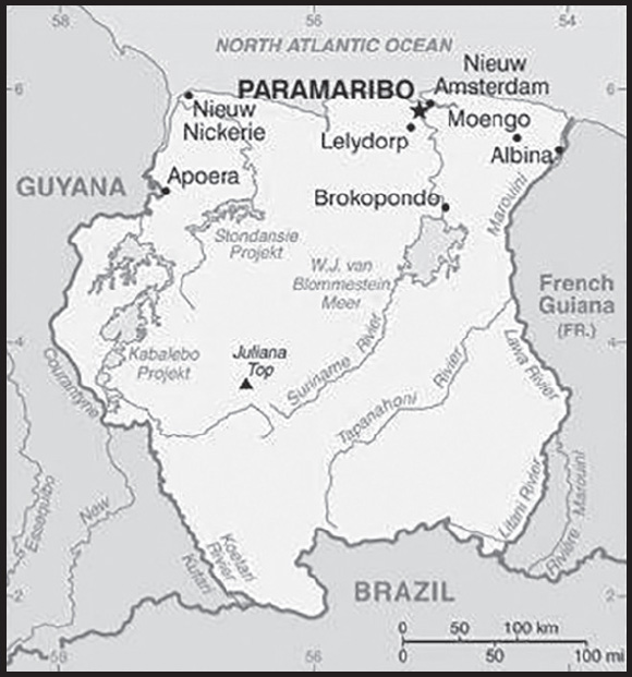
Location: Northern South America, bordering the North Atlantic Ocean, between French Guiana and Guyana
Geographic coordinates: 4 00 N, 56 00 W
Map references: South America
Area: total: 163,820 sq km
land: 156,000 sq km
water: 7,820 sq km
comparison ranking: total 92
Area - comparative: slightly larger than Georgia
Land boundaries: total: 1,907 km
border countries (3): Brazil 515 km; French Guiana 556 km; Guyana 836 km
Coastline: 386 km
Maritime claims: territorial sea: 12 nm
exclusive economic zone: 200 nm
Climate: tropical; moderated by trade winds
Terrain: mostly rolling hills; narrow coastal plain with swamps
Elevation: highest point: Juliana Top 1,230 m
lowest point: unnamed location in the coastal plain -2 m
mean elevation: 246 m
Natural resources: timber, hydropower, fish, kaolin, shrimp, bauxite, gold, and small amounts of nickel, copper, platinum, iron ore
Land use: agricultural land: 0.5% (2018 est.)
arable land: 0.4% (2018 est.)
permanent crops: 0% (2018 est.)
permanent pasture: 0.1% (2018 est.)
forest: 94.6% (2018 est.)
other: 4.9% (2018 est.)
Irrigated land: 600 sq km (2020)
Major watersheds (area sq km): Atlantic Ocean drainage: Amazon (6,145,186 sq km)
Population distribution: population concentrated along the nothern coastal strip; the remainder of the country is sparsely populated
Natural hazards: flooding
Geography - note: smallest independent country on South American continent; mostly tropical rain forest; great diversity of flora and fauna that, for the most part, is increasingly threatened by new development; relatively small population, mostly along the coast
PEOPLE AND SOCIETY
Population: 639,759 (2023 est.)
comparison ranking: 170
Nationality: noun: Surinamer(s)
adjective: Surinamese
Ethnic groups: Hindustani (also known locally as “East Indians”; their ancestors emigrated from northern India in the latter part of the 19th century) 27.4%, Maroon (their African ancestors were brought to the country in the 17th and 18th centuries as slaves and escaped to the interior) 21.7%, Creole (mixed White and Black) 15.7%, Javanese 13.7%, mixed 13.4%, other 7.6%, unspecified 0.6% (2012 est.)
Languages: Dutch (official), English (widely spoken), Sranang Tongo (Surinamese, sometimes called Taki-Taki, is the native language of Creoles and much of the younger population and is lingua franca among others), Caribbean Hindustani (a dialect of Hindi), Javanese
major-language sample(s):
Het Wereld Feitenboek, een omnisbare bron van informatie. (Dutch)
Religions: Protestant 23.6% (includes Evangelical 11.2%, Moravian 11.2%, Reformed .7%, Lutheran .5%), Hindu 22.3%, Roman Catholic 21.6%, Muslim 13.8%, other Christian 3.2%, Winti 1.8%, Jehovah’s Witness 1.2%, other 1.7%, none 7.5%, unspecified 3.2% (2012 est.)
Demographic profile: Suriname is a pluralistic society consisting primarily of Creoles (persons of mixed African and European heritage), the descendants of escaped African slaves known as Maroons, and the descendants of Indian and Javanese (Indonesian) contract workers. The country overall is in full, post-industrial demographic transition, with a low fertility rate, a moderate mortality rate, and a rising life expectancy. However, the Maroon population of the rural interior lags behind because of lower educational attainment and contraceptive use, higher malnutrition, and significantly less access to electricity, potable water, sanitation, infrastructure, and health care.
Some 350,000 people of Surinamese descent live in the Netherlands, Suriname’s former colonial ruler. In the 19th century, better-educated, largely Dutch-speaking Surinamese began emigrating to the Netherlands. World War II interrupted the outflow, but it resumed after the war when Dutch labor demands grew - emigrants included all segments of the Creole population. Suriname still is strongly influenced by the Netherlands because most Surinamese have relatives living there and it is the largest supplier of development aid. Other emigration destinations include French Guiana and the United States. Suriname’s immigration rules are flexible, and the country is easy to enter illegally because rainforests obscure its borders. Since the mid-1980s, Brazilians have settled in Suriname’s capital, Paramaribo, or eastern Suriname, where they mine gold. This immigration is likely to slowly re-orient Suriname toward its Latin American roots.
Age structure: 0-14 years: 22.77% (male 73,914/female 71,762)
15-64 years: 69.96% (male 223,807/female 223,762)
65 years and over: 7.27% (2023 est.) (male 19,152/female 27,362)
Dependency ratios: total dependency ratio: 50.9
youth dependency ratio: 40
elderly dependency ratio: 11
potential support ratio: 9.1 (2021 est.)
Median age: total: 31.6 years (2023 est.)
male: 30.7 years
female: 32.6 years
comparison ranking: total 118
Population growth rate: 1.11% (2023 est.)
comparison ranking: 85
Birth rate: 15.2 births/1,000 population (2023 est.)
comparison ranking: 111
Death rate: 6.6 deaths/1,000 population (2023 est.)
comparison ranking: 134
Net migration rate: 2.5 migrant(s)/1,000 population (2023 est.)
comparison ranking: 49
Population distribution: population concentrated along the nothern coastal strip; the remainder of the country is sparsely populated
Urbanization: urban population: 66.4% of total population (2023)
rate of urbanization: 0.88% annual rate of change (2020-25 est.)
Major urban areas - population: 239,000 PARAMARIBO (capital) (2018)
Sex ratio: at birth: 1.07 male(s)/female
0-14 years: 1.03 male(s)/female
15-64 years: 1 male(s)/female
65 years and over: 0.7 male(s)/female
total population: 0.98 male(s)/female (2023 est.)
Maternal mortality ratio: 96 deaths/100,000 live births (2020 est.)
comparison ranking: 71
Infant mortality rate: total: 29.9 deaths/1,000 live births (2023 est.)
male: 38 deaths/1,000 live births
female: 21.3 deaths/1,000 live births
comparison ranking: total 51
Life expectancy at birth: total population: 72.6 years (2023 est.)
male: 68.9 years
female: 76.5 years
comparison ranking: total population 155
Total fertility rate: 1.91 children born/woman (2023 est.)
comparison ranking: 119
Gross reproduction rate: 0.92 (2023 est.)
Contraceptive prevalence rate: 39.1% (2018)
Drinking water source: improved: urban: 99.5% of population
rural: 98.2% of population
total: 99.1% of population
unimproved: urban: 0.5% of population
rural: 1.8% of population
total: 0.9% of population (2020 est.)
Current health expenditure: 6.8% of GDP (2020)
Physicians density: 0.82 physicians/1,000 population (2018)
Hospital bed density: 3 beds/1,000 population (2017)
Sanitation facility access: improved: urban: 98.5% of population
rural: 91.2% of population
total: 96% of population
unimproved: urban: 1.5% of population
rural: 8.8% of population
total: 4% of population (2020 est.)
Major infectious diseases: degree of risk: very high (2023)
food or waterborne diseases: bacterial and protozoal diarrhea, hepatitis A, and typhoid fever
vectorborne diseases: malaria
Obesity - adult prevalence rate: 26.4% (2016)
comparison ranking: 41
Alcohol consumption per capita: total: 6.6 liters of pure alcohol (2019 est.)
beer: 3.4 liters of pure alcohol (2019 est.)
wine: 0.14 liters of pure alcohol (2019 est.)
spirits: 2.87 liters of pure alcohol (2019 est.)
other alcohols: 0.18 liters of pure alcohol (2019 est.)
comparison ranking: total 62
Children under the age of 5 years underweight: 6.7% (2018)
comparison ranking: 68
Currently married women (ages 15-49): 52.1% (2023 est.)
Child marriage: women married by age 15: 8.8%
women married by age 18: 36%
men married by age 18: 19.6% (2018 est.)
Education expenditures: 5% of GDP (2020 est.)
comparison ranking: 74
Literacy: definition: age 15 and over can read and write
total population: 95%
male: 96.5%
female: 93.4% (2021)
Youth unemployment rate (ages 15-24): total: 30.5% (2021 est.)
male: 22.1%
female: 46.1%
comparison ranking: total 37
ENVIRONMENT
Environment - current issues: deforestation as timber is cut for export; pollution of inland waterways by small-scale mining activities
Environment - international agreements: party to: Biodiversity, Climate Change, Climate Change-Kyoto Protocol, Climate Change-Paris Agreement, Comprehensive Nuclear Test Ban, Desertification, Endangered Species, Hazardous Wastes, Law of the Sea, Marine Dumping-London Convention, Marine Dumping-London Protocol, Nuclear Test Ban, Ozone Layer Protection, Ship Pollution, Tropical Timber 2006, Wetlands, Whaling
signed, but not ratified: none of the selected agreements
Climate: tropical; moderated by trade winds
Land use: agricultural land: 0.5% (2018 est.)
arable land: 0.4% (2018 est.)
permanent crops: 0% (2018 est.)
permanent pasture: 0.1% (2018 est.)
forest: 94.6% (2018 est.)
other: 4.9% (2018 est.)
Urbanization: urban population: 66.4% of total population (2023)
rate of urbanization: 0.88% annual rate of change (2020-25 est.)
Revenue from forest resources: 2.36% of GDP (2018 est.)
comparison ranking: 29
Revenue from coal: 0% of GDP (2018 est.)
comparison ranking: 140
Air pollutants: particulate matter emissions: 12.17 micrograms per cubic meter (2019 est.)
carbon dioxide emissions: 1.74 megatons (2016 est.)
methane emissions: 2.28 megatons (2020 est.)
Waste and recycling: municipal solid waste generated annually: 78,620 tons (2010 est.)
Major watersheds (area sq km): Atlantic Ocean drainage: Amazon (6,145,186 sq km)
Total water withdrawal: municipal: 50 million cubic meters (2020 est.)
industrial: 140 million cubic meters (2020 est.)
agricultural: 430 million cubic meters (2020 est.)
Total renewable water resources: 99 billion cubic meters (2020 est.)
GOVERNMENT
Country name: conventional long form: Republic of Suriname
conventional short form: Suriname
local long form: Republiek Suriname
local short form: Suriname
former: Netherlands Guiana, Dutch Guiana
etymology: name may derive from the indigenous “Surinen” people who inhabited the area at the time of European contact
Government type: presidential republic
Capital: name: Paramaribo
geographic coordinates: 5 50 N, 55 10 W
time difference: UTC-3 (2 hours ahead of Washington, DC, during Standard Time)
etymology: the name may be the corruption of a Carib (Kalina) village or tribe named Parmirbo
Administrative divisions: 10 districts (distrikten, singular - distrikt); Brokopondo, Commewijne, Coronie, Marowijne, Nickerie, Para, Paramaribo, Saramacca, Sipaliwini, Wanica
Independence: 25 November 1975 (from the Netherlands)
National holiday: Independence Day, 25 November (1975)
Constitution: history: previous 1975; latest ratified 30 September 1987, effective 30 October 1987
amendments: proposed by the National Assembly; passage requires at least two-thirds majority vote of the total membership; amended 1992
Legal system: civil law system influenced by Dutch civil law; note - a new criminal code was enacted in 2017
International law organization participation: accepts compulsory ICJ jurisdiction with reservations; accepts ICCt jurisdiction
Citizenship: citizenship by birth: no
citizenship by descent only: at least one parent must be a citizen of Suriname
dual citizenship recognized: no
residency requirement for naturalization: 5 years
Suffrage: 18 years of age; universal
Executive branch: chief of state: President Chandrikapersad SANTOKHI (since 16 July 2020); Vice President Ronnie BRUNSWIJK (since 16 July 2020); note - the president is both chief of state and head of government
head of government: President Chandrikapersad SANTOKHI (since 16 July 2020); Vice President Ronnie BRUNSWIJK (since 16 July 2020)
cabinet: Cabinet of Ministers appointed by the president
elections/appointments: president and vice president indirectly elected by the National Assembly; president and vice president serve a 5-year term (no term limits); election last held on 13 July 2020 (next to be held in May 2025)
election results: Chandrikapersad SANTOKHI elected president unopposed; National Assembly vote - NA
Legislative branch: description: unicameral National Assembly or Nationale Assemblee (51 seats; members directly elected in 10 multiseat constituencies by party-list proportional representation vote, using the D’Hondt method, to serve 5-year terms)
elections: last held on 25 May 2020 (next to be held in May 2025)
election results: percent of vote by party - VHP 41.1%, NDP 29.4%, ABOP 17.6%, NPS 7.8%, other 3.9%; seats by party - VHP 20, NDP 16, ABOP 9, NPS 3, BEP 2, PL 2; composition - men 36, women 15, percent of women 29.4%
Judicial branch: highest court(s): High Court of Justice of Suriname (consists of the court president, vice president, and 4 judges); note - appeals beyond the High Court are referred to the Caribbean Court of Justice; human rights violations can be appealed to the Inter-American Commission on Human Rights with judgments issued by the Inter-American Court on Human Rights
judge selection and term of office: court judges appointed by the national president in consultation with the National Assembly, the State Advisory Council, and the Order of Private Attorneys; judges serve for life
subordinate courts: cantonal courts
Political parties and leaders: Brotherhood and Unity in Politics or BEP [Ronnie ASABINA]
Democratic Alternative ‘91 or DA91 [Angelique DEL CASTILHO]
General Liberation and Development Party or ABOP [Ronnie BRUNSWIJK}
National Democratic Party or NDP [Desire Delano BOUTERSE]
National Party of Suriname or NPS [Gregory RUSLAND]
Party for Democracy and Development in Unity or DOE [Carl BREEVELD]
Party for National Unity and Solidarity or KTPI [Iwan GANGA]
People’s Alliance (Pertjajah Luhur) or PL [Paul SOMOHARDJO]
Progressive Workers’ and Farmers’ Union or PALU [Jim HOK]
Progressive Reform Party or VHP [Chandrikapersad SANTOKHI]
Reform and Renewal Movement or HVB [Mike NOERSALIM]
Surinamese Labor Party or SPA [Guno CASTELEN]
International organization participation: ACP, AOSIS, Caricom, CD, CDB, CELAC, FAO, G-77, IADB, IBRD, ICAO, ICCt, ICRM, IDA, IDB, IFAD, IFC, IFRCS, IHO, ILO, IMF, IMO, Interpol, IOC, IOM, IPU, ISO (correspondent), ITU, ITUC (NGOs), LAES, MIGA, NAM, OAS, OIC, OPANAL, OPCW, PCA, Petrocaribe, UN, UNASUR, UNCTAD, UNESCO, UNIDO, UPU, WHO, WIPO, WMO, WTO
Diplomatic representation in the US: chief of mission: Ambassador Jan Marten Willem SCHALKWIJK (since 19 April 2022)
chancery: 4301 Connecticut Avenue NW, Suite 400, Washington, DC 20008
telephone: [1] (202) 629-4302
FAX: [1] (202) 629-4769
email address and website:
https://surinameembassy.org/index.html
consulate(s) general: Miami
Diplomatic representation from the US: chief of mission: Ambassador Robert J. FAUCHER (since 31 January 2023)
embassy: 165 Kristalstraat, Paramaribo
mailing address: 3390 Paramaribo Place, Washington DC 20521-3390
telephone: [597] 556-700
FAX: [597] 551-524
email address and website:
Flag description: five horizontal bands of green (top, double width), white, red (quadruple width), white, and green (double width); a large, yellow, five-pointed star is centered in the red band; red stands for progress and love, green symbolizes hope and fertility, white signifies peace, justice, and freedom; the star represents the unity of all ethnic groups; from its yellow light the nation draws strength to bear sacrifices patiently while working toward a golden future
National symbol(s): royal palm, faya lobi (flower); national colors: green, white, red, yellow
National anthem: name: “God zij met ons Suriname!” (God Be With Our Suriname)
lyrics/music: Cornelis Atses HOEKSTRA and Henry DE ZIEL/Johannes Corstianus DE PUY
note: adopted 1959; originally adapted from a Sunday school song written in 1893 and contains lyrics in both Dutch and Sranang Tongo
National heritage: total World Heritage Sites: 2 (1 cultural, 1 natural)
selected World Heritage Site locales: Central Suriname Nature Reserve (n); Historic Inner City of Paramaribo (c)
ECONOMY
Economic overview: upper middle-income South American economy; new floating currency regime; key aluminum goods, gold, and hydrocarbon exporter; new IMF plan for economic recovery and fiscal sustainability; controversial hardwood industry
Real GDP (purchasing power parity): $9.052 billion (2021 est.)
$9.306 billion (2020 est.)
$11.075 billion (2019 est.)
note: data are in 2017 dollars
comparison ranking: 166
Real GDP growth rate: -2.73% (2021 est.)
-15.98% (2020 est.)
1.17% (2019 est.)
comparison ranking: 208
Real GDP per capita: $14,800 (2021 est.)
$15,300 (2020 est.)
$18,400 (2019 est.)
note: data are in 2017 dollars
comparison ranking: 108
GDP (official exchange rate): $3.419 billion (2017 est.)
Inflation rate (consumer prices): 59.11% (2021 est.)
34.89% (2020 est.)
22% (2017 est.)
comparison ranking: 5
Credit ratings: Fitch rating: C (2020)
Moody’s rating: Caa3 (2020)
Standard & Poors rating: SD (2020)
note: The year refers to the year in which the current credit rating was first obtained.
GDP - composition, by sector of origin: agriculture: 11.6% (2017 est.)
industry: 31.1% (2017 est.)
services: 57.4% (2017 est.)
comparison rankings: services 140; industry 71; agriculture 84
GDP - composition, by end use: household consumption: 27.6% (2017 est.)
government consumption: 11.7% (2017 est.)
investment in fixed capital: 52.5% (2017 est.)
investment in inventories: 26.5% (2017 est.)
exports of goods and services: 68.9% (2017 est.)
imports of goods and services: -60.6% (2017 est.)
Agricultural products: rice, sugar cane, bananas, oranges, vegetables, plantains, coconuts, poultry, cassava, eggs
Industries: gold mining, oil, lumber, food processing, fishing
Industrial production growth rate: -10.92% (2021 est.)
comparison ranking: 201
Labor force: 244,200 (2021 est.)
comparison ranking: 170
Labor force - by occupation: agriculture: 11.2%
industry: 19.5%
services: 69.3% (2010)
Unemployment rate: 10.06% (2021 est.)
9.78% (2020 est.)
8.04% (2019 est.)
comparison ranking: 70
Youth unemployment rate (ages 15-24): total: 30.5% (2021 est.)
male: 22.1%
female: 46.1%
comparison ranking: total 37
Population below poverty line: 70% (2002 est.)
Budget: revenues: $863 million (2019 est.)
expenditures: $1.648 billion (2019 est.)
Budget surplus (+) or deficit (-): -7.8% (of GDP) (2017 est.)
comparison ranking: 196
Public debt: 69.3% of GDP (2017 est.)
75.8% of GDP (2016 est.)
comparison ranking: 63
Taxes and other revenues: 16.4% (of GDP) (2017 est.)
comparison ranking: 130
Fiscal year: calendar year
Current account balance: $176.13 million (2021 est.)
$259.846 million (2020 est.)
-$448.255 million (2019 est.)
comparison ranking: 63
Exports: $2.299 billion (2021 est.) note: data are in current year dollars
$2.446 billion (2020 est.) note: data are in current year dollars
$2.287 billion (2019 est.)
comparison ranking: 155
Exports - partners: Switzerland 51%, United Arab Emirates 22%, Belgium 6%, Trinidad and Tobago 2%, Guyana 2% (2021)
Exports - commodities: gold, lumber, refined petroleum, excavation machinery, rice (2021)
Imports: $1.876 billion (2021 est.) note: data are in current year dollars
$1.845 billion (2020 est.) note: data are in current year dollars
$2.413 billion (2019 est.)
comparison ranking: 176
Imports - partners: United States 19%, China 16%, Netherlands 15%, Trinidad and Tobago 8%, Japan 3% (2021)
Imports - commodities: refined petroleum, excavation machinery, delivery trucks, cars, cigarettes (2021)
Reserves of foreign exchange and gold: $992.257 million (31 December 2021 est.)
$584.929 million (31 December 2020 est.)
$647.935 million (31 December 2019 est.)
comparison ranking: 145
Debt - external: $1.7 billion (31 December 2017 est.)
$1.436 billion (31 December 2016 est.)
comparison ranking: 156
Exchange rates: Surinamese dollars (SRD) per US dollar -
Exchange rates:
18.239 (2021 est.)
9.31 (2020 est.)
7.458 (2019 est.)
7.463 (2018 est.)
7.488 (2017 est.)
ENERGY
Electricity access: electrification - total population: 98.8% (2021)
electrification - urban areas: 99.5% (2021)
electrification - rural areas: 97.4% (2021)
Electricity: installed generating capacity: 542,000 kW (2020 est.)
consumption: 2,938,391,000 kWh (2019 est.)
exports: 0 kWh (2019 est.)
imports: 808 million kWh (2019 est.)
transmission/distribution losses: 234 million kWh (2019 est.)
comparison rankings: installed generating capacity 150; transmission/distribution losses 146; imports 77; exports 183; consumption 141
Electricity generation sources: fossil fuels: 40.5% of total installed capacity (2020 est.)
solar: 0.4% of total installed capacity (2020 est.)
hydroelectricity: 58.8% of total installed capacity (2020 est.)
biomass and waste: 0.3% of total installed capacity (2020 est.)
Petroleum: total petroleum production: 14,800 bbl/day (2021 est.)
refined petroleum consumption: 15,800 bbl/day (2019 est.)
crude oil and lease condensate exports: 0 bbl/day (2018 est.)
crude oil and lease condensate imports: 200 bbl/day (2018 est.)
crude oil estimated reserves: 89 million barrels (2021 est.)
Refined petroleum products - production: 7,571 bbl/day (2015 est.)
comparison ranking: 101
Refined petroleum products - exports: 14,000 bbl/day (2015 est.)
comparison ranking: 74
Refined petroleum products - imports: 10,700 bbl/day (2015 est.)
comparison ranking: 145
Carbon dioxide emissions: 2.372 million metric tonnes of CO2 (2019 est.)
from petroleum and other liquids: 2.361 million metric tonnes of CO2 (2019 est.)
from consumed natural gas: 11,000 metric tonnes of CO2 (2019 est.)
comparison ranking: total emissions 156
Energy consumption per capita: 82.356 million Btu/person (2019 est.)
comparison ranking: 71
COMMUNICATIONS
Telephones - fixed lines: total subscriptions: 119,977 (2021 est.)
subscriptions per 100 inhabitants: 20 (2021 est.)
comparison ranking: total subscriptions 131
Telephones - mobile cellular: total subscriptions: 906,170 (2021 est.)
subscriptions per 100 inhabitants: 148 (2021 est.)
comparison ranking: total subscriptions 164
Telecommunication systems: general assessment:
Suriname is the smallest nation on the South American continent, with about 580,000 inhabitants; the only Dutch-speaking nation in South America, it has close affinities with the Caribbean, and is a member of the Caribbean Community and Common Market (CARICOM); the country’s fixed-line infrastructure is reasonably reliable in the more populated coastal region, though poor in the interior; fixed teledensity and broadband penetration are slightly lower than average for Latin America and the Caribbean, while mobile penetration is significantly above the regional average and much higher than would be expected given the country’s relatively low GDP per capita; many Surinamese have up to three mobile lines with different providers, which has pushed up penetration figures although the number of subscribers has fallen in recent years as consumers have responded to economic pressures
(2021)
domestic: fixed-line is 20 per 100 and mobile-cellular teledensity is 148 telephones per 100 persons (2021)
international: country code - 597; landing point for the SG-SCS submarine cable linking South America with the Caribbean; satellite earth stations - 2 Intelsat (Atlantic Ocean) (2019)
Broadcast media: 2 state-owned TV stations; 1 state-owned radio station; multiple private radio and TV stations (2019)
Internet country code: .sr
Internet users: total: 402,600 (2021 est.)
percent of population: 66% (2021 est.)
comparison ranking: total 172
Broadband - fixed subscriptions: total: 92,270 (2020 est.)
subscriptions per 100 inhabitants: 16 (2020 est.)
comparison ranking: total 129
TRANSPORTATION
National air transport system: number of registered air carriers: 4 (2020)
inventory of registered aircraft operated by air carriers: 20
annual passenger traffic on registered air carriers: 272,347 (2018)
annual freight traffic on registered air carriers: 33.2 million (2018) mt-km
Civil aircraft registration country code prefix: PZ
Airports: 55 (2021)
comparison ranking: total 84
Airports - with paved runways: 6
note: paved runways have a concrete or asphalt surface but not all have facilities for refueling, maintenance, or air traffic control; the length of a runway required for aircraft to safely operate depends on a number of factors including the type of aircraft, the takeoff weight (including passengers, cargo, and fuel), engine types, flap settings, landing speed, elevation of the airport, and average maximum daily air temperature; paved runways can reach a length of 5,000 m (16,000 ft.), but the “typical” length of a commercial airline runway is between 2,500-4,000 m (8,000-13,000 ft.)
Airports - with unpaved runways: 49
note: unpaved runways have a surface composition such as grass or packed earth and are most suited to the operation of light aircraft; unpaved runways are usually short, often less than 1,000 m (3,280 ft.) in length; airports with unpaved runways often lack facilities for refueling, maintenance, or air traffic control
Pipelines: 50 km oil (2013)
Roadways: total: 4,304 km (2003)
paved: 1,119 km (2003)
unpaved: 3,185 km (2003)
comparison ranking: total 151
Waterways: 1,200 km (2011) (most navigable by ships with drafts up to 7 m)
comparison ranking: 63
Merchant marine: total: 10 (2022)
by type: general cargo 5, oil tanker 3, other 2
comparison ranking: total 157
Ports and terminals: major seaport(s): Paramaribo, Wageningen
MILITARY AND SECURITY
Military and security forces: Suriname National Army (Nationaal Leger or NL); Army (Landmacht), Navy (Marine); Air Force (Luchtmacht), Military Police (Korps Militaire Politie)
Ministry of Justice and Police: Suriname Police Force (Korps Politie Suriname or KPS) (2023)
Military expenditures: 1.2% of GDP (2019 est.)
1.1% of GDP (2018 est.)
1.1% of GDP (2017 est.)
1.2% of GDP (2016 est.)
1.4% of GDP (2015 est.)
comparison ranking: 114
Military and security service personnel strengths: approximately 2,000 total personnel (2023)
Military equipment inventories and acquisitions: the Suriname Army has a limited inventory comprised of a mix of older, foreign-supplied equipment; in recent years, Suriname has received small quantities of military hardware from India (2023)
Military service age and obligation: 18 is the legal minimum age for voluntary military service for men and women; no conscription (2022)
Military - note: key missions for the National Leger include border control and supporting domestic security; the military police has direct responsibility for immigration control at the country’s ports of entry; in addition, the military assists the police in combating crime, particularly narco-trafficking, including joint military and police patrols, as well as joint special security teams (2023)
TRANSNATIONAL ISSUES
Disputes - international: Suriname-Brazil: none identified
Suriname-France (French Guiana): in March 2021, Suriname and France signed an agreement to establish their border along the Maroni River and its tributary the Lawa River and to cooperate in combatting illegal gold mining; however, the area further south between the Litani and Marouini Rivers is still disputed, with Suriname claiming the border is along the Marouini to the east and France arguing it is along the Litani River to the west
Suriname-Guyana: the two countries dispute the territory between two rivers, known as the New River Triangle, with Suriname contending that the New River (also called the Upper Corentyne) to the west marks their common border, while Guyana asserts that the Kutari River to the east forms the border; each side claims that their river is the source of the Corentyne River that forms a border further north between the two countries; the Permanent Court of Arbitration settled the maritime boundary between Suriname and Guyana in 2007 in an area with potentially substantial oil reserves
Illicit drugs: a transit country for South American cocaine en route to Europe; illicit drugs are smuggled in cargo containers, commercial and private air transport and human couriers
SVALBARD
INTRODUCTION
Background: The archipelago may have been first discovered by Norse explorers in the 12th century; the islands served as an international whaling base during the 17th and 18th centuries. Norway’s sovereignty was internationally recognized by treaty in 1920, and five years later it officially took over the territory. In the 20th century, coal mining started and today a Norwegian and a Russian company are still functioning. Travel between the settlements is accomplished with snowmobiles, aircraft, and boats.
GEOGRAPHY
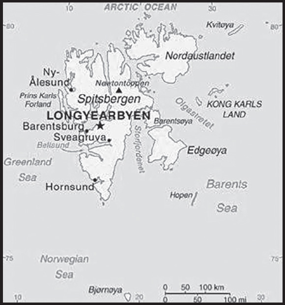
Location: Northern Europe, islands between the Arctic Ocean, Barents Sea, Greenland Sea, and Norwegian Sea, north of Norway
Geographic coordinates: 78 00 N, 20 00 E
Map references: Arctic Region
Area: total: 62,045 sq km
land: 62,045 sq km
water: 0 sq km
note: includes Spitsbergen and Bjornoya (Bear Island)
comparison ranking: total 125
Area - comparative: slightly smaller than West Virginia
Land boundaries: total: 0 km
Coastline: 3,587 km
Maritime claims: territorial sea: 12 nm
contiguous zone: 24 nm
continental shelf: extends to depth of exploitation
exclusive fishing zone: 200 nm
Climate: arctic, tempered by warm North Atlantic Current; cool summers, cold winters; North Atlantic Current flows along west and north coasts of Spitsbergen, keeping water open and navigable most of the year
Terrain: rugged mountains; much of the upland areas are ice covered; west coast clear of ice about half the year; fjords along west and north coasts
Elevation: highest point: Newtontoppen 1,717 m
lowest point: Arctic Ocean 0 m
Natural resources: coal, iron ore, copper, zinc, phosphate, wildlife, fish
Land use: agricultural land: 0% (2018 est.)
other: 100% (2018 est.)
Population distribution: the small population is primarily concentrated on the island of Spitsbergen in a handful of settlements on the south side of the Isfjorden, with Longyearbyen being the largest
Natural hazards: ice floes often block the entrance to Bellsund (a transit point for coal export) on the west coast and occasionally make parts of the northeastern coast inaccessible to maritime traffic
Geography - note: northernmost part of the Kingdom of Norway; consists of nine main islands; glaciers and snowfields cover 60% of the total area; Spitsbergen Island is the site of the Svalbard Global Seed Vault, a seed repository established by the Global Crop Diversity Trust and the Norwegian Government
PEOPLE AND SOCIETY
Population: 2,926 (January 2021 est.)
comparison ranking: 229
Ethnic groups: Norwegian 61.1%, foreign population 38.9% (consists primarily of Russians, Thais, Swedes, Filipinos, and Ukrainians) (2021 est.)
note: foreigners account for almost one third of the population of the Norwegian settlements, Longyearbyen and Ny-Alesund (where the majority of Svalbard’s resident population lives), as of mid-2021
Languages: Norwegian, Russian
major-language sample(s):
Verdens Faktabok, den essensielle kilden for grunnleggende informasjon. (Norwegian)
Population growth rate: -0.03% (2019 est.)
comparison ranking: 199
Net migration rate: -5.57 migrant(s)/1,000 population (2021 est.)
comparison ranking: 207
Population distribution: the small population is primarily concentrated on the island of Spitsbergen in a handful of settlements on the south side of the Isfjorden, with Longyearbyen being the largest
ENVIRONMENT
Environment - current issues: ice floes are a maritime hazard; past exploitation of mammal species (whale, seal, walrus, and polar bear) severely depleted the populations, but a gradual recovery seems to be occurring
Climate: arctic, tempered by warm North Atlantic Current; cool summers, cold winters; North Atlantic Current flows along west and north coasts of Spitsbergen, keeping water open and navigable most of the year
Land use: agricultural land: 0% (2018 est.)
other: 100% (2018 est.)
GOVERNMENT
Country name: conventional long form: none
conventional short form: Svalbard (sometimes referred to as Spitsbergen, the largest island in the archipelago)
etymology: 12th century Norse accounts speak of the discovery of a “Svalbard” - literally “cold shores” - but they may have referred to Jan Mayen Island or eastern Greenland; the archipelago was traditionally known as Spitsbergen, but Norway renamed it Svalbard in the 1920s when it assumed sovereignty of the islands
Government type: non-self-governing territory of Norway
Dependency status: territory of Norway; administered by the Polar Department of the Ministry of Justice, through a governor (sysselmann) residing in Longyearbyen, Spitsbergen; by treaty (9 February 1920), sovereignty was awarded to Norway
Capital: name: Longyearbyen
geographic coordinates: 78 13 N, 15 38 E
time difference: UTC+1 (6 hours ahead of Washington, DC, during Standard Time)
daylight saving time: +1hr, begins last Sunday in March; ends last Sunday in October
etymology: the name in Norwegian means Longyear Town; the site was established by and named after John LONGYEAR, whose Arctic Coal Company began mining operations there in 1906
Independence: none (territory of Norway)
Legal system: only the laws of Norway made explicitly applicable to Svalbard have effect there; the Svalbard Act and the Svalbard Environmental Protection Act, and certain regulations, apply only to Svalbard; the Spitsbergen Treaty and the Svalbard Treaty grant certain rights to citizens and corporations of signatory nations; as of June 2017, 45 nations had ratified the Svalbard Treaty
Citizenship: see Norway
Executive branch: chief of state: King HARALD V of Norway (since 17 January 1991); Heir Apparent Crown Prince Haakon MAGNUS (son of the king, born 20 July 1973)
head of government: Governor Lars FAUSE (since 24 June 2021); Vice Governor Solvi ELVEDAHL (since 1 May 2020)
elections/appointments: none; the monarchy is hereditary; governor and assistant governor responsible to the Polar Department of the Ministry of Justice
Legislative branch: description: unicameral Longyearbyen Community Council (15 seats; members directly elected by majority vote to serve 4-year-terms); note - the Council acts very much like a Norwegian municipality, responsible for infrastructure and utilities, including power, land-use and community planning, education, and child welfare; however, healthcare services are provided by the state
elections: last held on 9 October 2023 (next to be held in October 2027)
election results: seats by party - Liberals 7, Labor 3, Social Liberals 3, Conservatives 2
Judicial branch: highest court(s): none; note - Svalbard is subordinate to Norway’s Nord-Troms District Court and Halogaland Court of Appeal, both located in Tromso
Political parties and leaders: Conservative [Celine ANDERSSEN]
Green [Pal BERG]
Labor [Arild OLSEN]
Liberal [Terje AUVENIK]
Progress [Jorn DYBDAHL]
Social Liberals []
International organization participation: none
Flag description: the flag of Norway is used
National anthem: note: as a territory of Norway, “Ja, vi elsker dette landet” is official (see Norway)
ECONOMY
Economic overview: high-income Norwegian island economy; major coal mining, tourism, and research sectors; recently established northernmost brewery; key whaling and fishing base; home to the Global Seed Vault
Labor force: 1,590 (2013)
comparison ranking: 228
Exchange rates: Norwegian kroner (NOK) per US dollar -
Exchange rates:
8.308 (2017 est.)
8.0646 (2016 est.)
8.0646 (2015)
8.0646 (2014 est.)
6.3021 (2013 est.)
ENERGY
Refined petroleum products - exports: 4,488 bbl/day (2012 est.)
comparison ranking: 93
Refined petroleum products - imports: 18,600 bbl/day (2012 est.)
comparison ranking: 127
COMMUNICATIONS
Telecommunication systems: general assessment: Svalbard Undersea Cable System is a twin submarine communications cable which connects Svalbard to the mainland of Norway (2022)
domestic: the Svalbard Satellite Station - connected to the mainland via the Svalbard Undersea Cable System - is the only Arctic ground station that can see low-altitude, polar-orbiting satellites; it provides ground services to more satellites than any other facility in the world (2022)
international: country code - 47-790; the Svalbard Undersea Cable System is a twin communications cable that connects Svalbard to mainland Norway; the system is the sole telecommunications link to the archipelago (2019)
Broadcast media: the Norwegian Broadcasting Corporation (NRK) began direct TV transmission to Svalbard via satellite in 1984; Longyearbyen households have access to 3 NRK radio and 2 TV stations
Internet country code: .sj
TRANSPORTATION
Airports: 4 (2021)
comparison ranking: total 188
Airports - with paved runways: 1
note: paved runways have a concrete or asphalt surface but not all have facilities for refueling, maintenance, or air traffic control; the length of a runway required for aircraft to safely operate depends on a number of factors including the type of aircraft, the takeoff weight (including passengers, cargo, and fuel), engine types, flap settings, landing speed, elevation of the airport, and average maximum daily air temperature; paved runways can reach a length of 5,000 m (16,000 ft.), but the “typical” length of a commercial airline runway is between 2,500-4,000 m (8,000-13,000 ft.)
Airports - with unpaved runways: 3
note: unpaved runways have a surface composition such as grass or packed earth and are most suited to the operation of light aircraft; unpaved runways are usually short, often less than 1,000 m (3,280 ft.) in length; airports with unpaved runways often lack facilities for refueling, maintenance, or air traffic control
Heliports: 1 (2021)
Roadways: total: 40 km (2020)
comparison ranking: total 217
Ports and terminals: major seaport(s): Barentsburg, Longyearbyen, Ny-Alesund, Pyramiden
MILITARY AND SECURITY
Military and security forces: no regular military forces
Military - note: Svalbard is a territory of Norway, demilitarized by treaty on 9 February 1920; Norwegian military activity is limited to fisheries surveillance by the Norwegian Coast Guard (2023)
TRANSNATIONAL ISSUES
Disputes - international: Norway-Russia: after 40 years of on-again, off-again negotiations, the two countries signed an agreement in September 2010, defining their maritime boundaries in the Barents Sea and the Arctic Ocean; the border extends the countries’ land border northward beyond the islands in the Barents Sea and into the Arctic Ocean, but the exact distance northward was not specified; because the area is considered the high seas, the passage of naval and commercial vessels will be unaffected; once their legislatures ratify the agreement, both countries will have the green light for oil and natural gas exploration in their newly defined maritime areas; Russia objects to Norway’s establishment in 1977 of the Fishery Protection Zone around the Svalbard Islands, extending Norwegian sovereignty to the shelf around the archipelago; Svalbard is strategically important – as a gateway from the Berents Sea to the North Atlantic – and its waters provide rich fishing grounds
SWEDEN
INTRODUCTION
Background: A military power during the 17th century, Sweden maintained a policy of military non-alignment until it applied to join NATO in May 2022. Stockholm preserved and armed neutrality in both World Wars. Since then, Sweden has pursued a successful economic formula consisting of a capitalist system intermixed with substantial welfare elements. Sweden joined the EU in 1995, but the public rejected the introduction of the euro in a 2003 referendum. The share of Sweden’s population born abroad increased from 11.3% in 2000 to 20% in 2021.
GEOGRAPHY
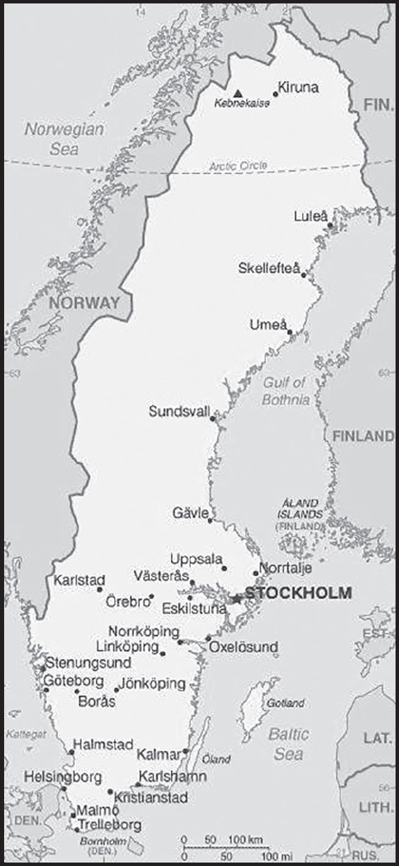
Location: Northern Europe, bordering the Baltic Sea, Gulf of Bothnia, Kattegat, and Skagerrak, between Finland and Norway
Geographic coordinates: 62 00 N, 15 00 E
Map references: Europe
Area: total: 450,295 sq km
land: 410,335 sq km
water: 39,960 sq km
comparison ranking: total 58
Area - comparative: almost three times the size of Georgia; slightly larger than California
Land boundaries: total: 2,211 km
border countries (2): Finland 545 km; Norway 1,666 km
Coastline: 3,218 km
Maritime claims: territorial sea: 12 nm (adjustments made to return a portion of straits to high seas)
exclusive economic zone: agreed boundaries or midlines
continental shelf: 200-m depth or to the depth of exploitation
Climate: temperate in south with cold, cloudy winters and cool, partly cloudy summers; subarctic in north
Terrain: mostly flat or gently rolling lowlands; mountains in west
Elevation: highest point: Kebnekaise South 2,100 m
lowest point: reclaimed bay of Lake Hammarsjon, near Kristianstad -2.4 m
mean elevation: 320 m
Natural resources: iron ore, copper, lead, zinc, gold, silver, tungsten, uranium, arsenic, feldspar, timber, hydropower
Land use: agricultural land: 7.5% (2018 est.)
arable land: 6.4% (2018 est.)
permanent crops: 0% (2018 est.)
permanent pasture: 1.1% (2018 est.)
forest: 68.7% (2018 est.)
other: 23.8% (2018 est.)
Irrigated land: 519 sq km (2013)
Major lakes (area sq km): fresh water lake(s): Vanern - 5,580 sq km; Vattern - 1,910 sq km; Malaren - 1,140 sq km
Population distribution: most Swedes live in the south where the climate is milder and there is better connectivity to mainland Europe; population clusters are found all along the Baltic coast in the east; the interior areas of the north remain sparsely populated
Natural hazards: ice floes in the surrounding waters, especially in the Gulf of Bothnia, can interfere with maritime traffic
Geography - note: strategic location along Danish Straits linking Baltic and North Seas; Sweden has almost 100,000 lakes, the largest of which, Vanern, is the third largest in Europe
PEOPLE AND SOCIETY
Population: 10,536,338 (2023 est.)
comparison ranking: 88
Nationality: noun: Swede(s)
adjective: Swedish
Ethnic groups: Swedish 80.3%, Syrian 1.9%, Iraqi 1.4%, Finnish 1.4%, other 15%
(2020 est.)
note: data represent the population by country of birth; the indigenous Sami people are estimated to number between 20,000 and 40,000
Languages: Swedish (official)
major-language sample(s):
The World Factbook, den obestridliga källan för grundläggande information. (Swedish)
note: Finnish, Sami, Romani, Yiddish, and Meankieli are official minority languages
Religions: Church of Sweden (Lutheran) 57.6%, other (includes Roman Catholic, Orthodox, Baptist, Muslim, Jewish, and Buddhist) 8.9%, none or unspecified 33.5% (2019 est.)
note: estimates reflect registered members of faith communities eligible for state funding (not all religions are state-funded and not all people who identify with a particular religion are registered members) and the Church of Sweden
Demographic profile: Sweden, the largest Nordic country in terms of size and population, is also Europe’s most sparsely populated. Most Swedish men and women agree that both partners should contribute to household income. Swedish society is very gender equal, which is reflected in the country’s public policies. A generous leave policy and high-quality subsidized childcare allows mothers and fathers to balance work and family life. Sweden’s income-replacement-based parental leave policy encourages women to establish themselves in the workforce before having children. In fact, Swedish women have one of the highest labor participation rates in Europe and one of its highest total fertility rates (TFR), the number of children women have in their lifetime. Postponement of parenthood has increased steadily. Since the late 1960s, marriage and divorce rates have declined, while non-marital cohabitation and births out of wedlock have increased rapidly. Sweden’s TFR has hovered for decades around 2, which is close to replacement level and among Europe’s highest.
Sweden experienced “the great emigration” between 1850 and the 1930s when, faced with famines, approximately 1.5 million Swedes sought a better life in the Americas and Australia. However, since World War II, Sweden has been a country of immigration. During World War II, thousands of refugees from neighboring countries worked in Swedish factories, agriculture, and forestry, replacing Swedish men who were called up for military service. During the 1950s and 1960s, Sweden joined the Geneva Convention and granted permanent residence to refugees from the USSR and the Warsaw Pact countries. During this period, Sweden also welcomed labor migrants, mainly from Finland and other Nordic countries, who bolstered the tax base needed to fund the country’s welfare programs.
Until 1971, labor migrants, particularly from Finland, southern Europe (including then Yugoslavia, Italy, and Greece) the Baltics, and Turkey, came to Sweden as its industries flourished. Companies recruited many of the workers, but others came on their own. Sweden’s labor demand eventually decreased, and the job market became saturated. The government restricted the flow of labor migrants, putting an end to labor migration from non-Nordic countries in 1972. From then until the 1990s, inflows consisted largely of asylum seekers from the Middle East, the Balkans, and South America, as well as persons looking to reunite with family members already in Sweden. The country began a new era of labor immigration in 2008, as companies were encouraged to hire non-EU workers. Among the largest source countries have been India, Thailand, and China. As of 2020, over a quarter of Sweden’s population had a migrant background.
Age structure: 0-14 years: 17.26% (male 936,274/female 882,347)
15-64 years: 62.05% (male 3,346,891/female 3,190,608)
65 years and over: 20.69% (2023 est.) (male 1,021,707/female 1,158,511)
Dependency ratios: total dependency ratio: 60.8
youth dependency ratio: 28.5
elderly dependency ratio: 32.3
potential support ratio: 3.1 (2021 est.)
Median age: total: 41 years (2023 est.)
male: 40 years
female: 42 years
comparison ranking: total 51
Population growth rate: 0.51% (2023 est.)
comparison ranking: 151
Birth rate: 10.8 births/1,000 population (2023 est.)
comparison ranking: 169
Death rate: 9.5 deaths/1,000 population (2023 est.)
comparison ranking: 45
Net migration rate: 3.8 migrant(s)/1,000 population (2023 est.)
comparison ranking: 33
Population distribution: most Swedes live in the south where the climate is milder and there is better connectivity to mainland Europe; population clusters are found all along the Baltic coast in the east; the interior areas of the north remain sparsely populated
Urbanization: urban population: 88.7% of total population (2023)
rate of urbanization: 0.89% annual rate of change (2020-25 est.)
Major urban areas - population: 1.700 million STOCKHOLM (capital) (2023)
Sex ratio: at birth: 1.06 male(s)/female
0-14 years: 1.06 male(s)/female
15-64 years: 1.05 male(s)/female
65 years and over: 0.88 male(s)/female
total population: 1.01 male(s)/female (2023 est.)
Mother’s mean age at first birth: 29.7 years (2020 est.)
Maternal mortality ratio: 5 deaths/100,000 live births (2020 est.)
comparison ranking: 170
Infant mortality rate: total: 2.3 deaths/1,000 live births (2023 est.)
male: 2.5 deaths/1,000 live births
female: 2.1 deaths/1,000 live births
comparison ranking: total 218
Life expectancy at birth: total population: 82.8 years (2023 est.)
male: 81.1 years
female: 84.7 years
comparison ranking: total population 20
Total fertility rate: 1.67 children born/woman (2023 est.)
comparison ranking: 169
Gross reproduction rate: 0.8 (2023 est.)
Contraceptive prevalence rate: 70.3% (2017)
note: percent of women aged 16-49
Drinking water source: improved: urban: 99.8% of population
rural: 99.7% of population
total: 99.8% of population
unimproved: urban: 0.2% of population
rural: 0.3% of population
total: 0.2% of population (2020 est.)
Current health expenditure: 11.4% of GDP (2020)
Physicians density: 7.09 physicians/1,000 population (2019)
Hospital bed density: 2.1 beds/1,000 population (2018)
Sanitation facility access: improved:
total: 100% of population
unimproved: total: 0% of population (2020 est.)
Obesity - adult prevalence rate: 20.6% (2016)
comparison ranking: 96
Alcohol consumption per capita: total: 7.1 liters of pure alcohol (2019 est.)
beer: 2.6 liters of pure alcohol (2019 est.)
wine: 3.4 liters of pure alcohol (2019 est.)
spirits: 1 liters of pure alcohol (2019 est.)
other alcohols: 0.1 liters of pure alcohol (2019 est.)
comparison ranking: total 59
Tobacco use: total: 24% (2020 est.)
male: 29.8% (2020 est.)
female: 18.2% (2020 est.)
comparison ranking: total 57
Currently married women (ages 15-49): 53.4% (2023 est.)
Education expenditures: 7.2% of GDP (2020 est.)
comparison ranking: 18
School life expectancy (primary to tertiary education): total: 20 years
male: 18 years
female: 21 years (2020)
Youth unemployment rate (ages 15-24): total: 24.5% (2021 est.)
male: 26.1%
female: 23%
comparison ranking: total 64
ENVIRONMENT
Environment - current issues: marine pollution (Baltic Sea and North Sea); acid rain damage to soils and lakes; air pollution; inappropriate timber harvesting practices
Environment - international agreements: party to: Air Pollution, Air Pollution-Heavy Metals, Air Pollution-Multi-effect Protocol, Air Pollution-Nitrogen Oxides, Air Pollution-Persistent Organic Pollutants, Air Pollution-Sulphur 85, Air Pollution-Sulphur 94, Air Pollution-Volatile Organic Compounds, Antarctic-Environmental Protection, Antarctic-Marine Living Resources, Antarctic Treaty, Biodiversity, Climate Change, Climate Change-Kyoto Protocol, Climate Change-Paris Agreement, Comprehensive Nuclear Test Ban, Desertification, Endangered Species, Environmental Modification, Hazardous Wastes, Law of the Sea, Marine Dumping-London Convention, Marine Dumping-London Protocol, Nuclear Test Ban, Ozone Layer Protection, Ship Pollution, Tropical Timber 2006, Wetlands, Whaling
signed, but not ratified: none of the selected agreements
Climate: temperate in south with cold, cloudy winters and cool, partly cloudy summers; subarctic in north
Land use: agricultural land: 7.5% (2018 est.)
arable land: 6.4% (2018 est.)
permanent crops: 0% (2018 est.)
permanent pasture: 1.1% (2018 est.)
forest: 68.7% (2018 est.)
other: 23.8% (2018 est.)
Urbanization: urban population: 88.7% of total population (2023)
rate of urbanization: 0.89% annual rate of change (2020-25 est.)
Revenue from forest resources: 0.21% of GDP (2018 est.)
comparison ranking: 91
Revenue from coal: 0% of GDP (2018 est.)
comparison ranking: 161
Air pollutants: particulate matter emissions: 5.96 micrograms per cubic meter (2019 est.)
carbon dioxide emissions: 43.25 megatons (2016 est.)
methane emissions: 4.42 megatons (2020 est.)
Waste and recycling: municipal solid waste generated annually: 4.377 million tons (2015 est.)
municipal solid waste recycled annually: 1,416,835 tons (2015 est.)
percent of municipal solid waste recycled: 32.4% (2015 est.)
Major lakes (area sq km): fresh water lake(s): Vanern - 5,580 sq km; Vattern - 1,910 sq km; Malaren - 1,140 sq km
Total water withdrawal: municipal: 700 million cubic meters (2020 est.)
industrial: 1.27 billion cubic meters (2020 est.)
agricultural: 100 million cubic meters (2020 est.)
Total renewable water resources: 174 billion cubic meters (2020 est.)
GOVERNMENT
Country name: conventional long form: Kingdom of Sweden
conventional short form: Sweden
local long form: Konungariket Sverige
local short form: Sverige
etymology: name ultimately derives from the North Germanic Svear tribe, which inhabited central Sweden and is first mentioned in the first centuries A.D.
Government type: parliamentary constitutional monarchy
Capital: name: Stockholm
geographic coordinates: 59 20 N, 18 03 E
time difference: UTC+1 (6 hours ahead of Washington, DC, during Standard Time)
daylight saving time: +1hr, begins last Sunday in March; ends last Sunday in October
etymology: stock and holm literally mean “log” and “islet” in Swedish, but there is no consensus as to what the words refer to
Administrative divisions: 21 counties (lan, singular and plural); Blekinge, Dalarna, Gavleborg, Gotland, Halland, Jamtland, Jonkoping, Kalmar, Kronoberg, Norrbotten, Orebro, Ostergotland, Skane, Sodermanland, Stockholm, Uppsala, Varmland, Vasterbotten, Vasternorrland, Vastmanland, Vastra Gotaland
Independence: 6 June 1523 (Gustav VASA elected king of Sweden, marking the abolishment of the Kalmar Union between Denmark, Norway, and Sweden)
National holiday: National Day, 6 June (1983); note - from 1916 to 1982 this date was celebrated as Swedish Flag Day
Constitution: history: Sweden has four fundamental laws which together make up the Constitution: The Instrument of Government (several previous; latest 1974); The Act of Succession (enacted 1810; changed in 1937 and 1980); The Freedom of the Press Act (many previous; latest in 1949); The Fundamental Law on Freedom of Expression (adopted 1991)
amendments: proposed by Parliament; passage requires simple majority vote in two consecutive parliamentary terms with an intervening general election; passage also requires approval by simple majority vote in a referendum if Parliament approves a motion for a referendum by one third of its members; The Instrument of Government - amended several times, last in 2018; The Act of Succession - changed in 1937, 1980; The Freedom of the Press Act - amended several times, last in 2019; The Fundamental Law on Freedom of Expression - amended several times, last in 2018
Legal system: civil law system influenced by Roman-Germanic law and customary law
International law organization participation: accepts compulsory ICJ jurisdiction with reservations; accepts ICCt jurisdiction
Citizenship: citizenship by birth: no
citizenship by descent only: the father must be a citizen of Sweden; in the case of a child born out of wedlock, the mother must be a citizen of Sweden and the father unknown
dual citizenship recognized: no, unless the other citizenship was acquired involuntarily
residency requirement for naturalization: 5 years
Suffrage: 18 years of age; universal
Executive branch: chief of state: King CARL XVI GUSTAF (since 15 September 1973); Heir Apparent Princess VICTORIA Ingrid Alice Desiree (daughter of the monarch, born 14 July 1977)
head of government: Prime Minister Ulf KRISTERSSON (since 18 October 2022); Deputy Prime Minister Ebba BUSCH (since 18 October 2022)
cabinet: Cabinet appointed by the prime minister
elections/appointments: the monarchy is hereditary; following legislative elections, the leader of the majority party or majority coalition usually becomes the prime minister
Legislative branch: description: unicameral Parliament or Riksdag (349 seats; 310 members directly elected in multi-seat constituencies by open party-list proportional representation vote and 39 members in “at-large” seats directly elected by open party-list proportional representation vote; members serve 4-year terms)
elections: last held on 11 September 2022 (next to beheld on 13 September 2026)
election results: percent of vote by party - S/SAP 30.3%, M 19.1%, SD 20.5%, C 6.7%, V 6.7%, KD 5.3%, L 4.6%, MP 5.1%, other 1.7%; seats by party - S/SAP 107, M 68, SD 73, C 24, V 24, KD 19, L 16, MP 18; composition as of mid-2022 - men 188, women 161, percent of women 46%
Judicial branch: highest court(s): Supreme Court of Sweden (consists of 16 justices, including the court chairman); Supreme Administrative Court (consists of 18 justices, including the court president)
judge selection and term of office: Supreme Court and Supreme Administrative Court justices nominated by the Judges Proposal Board, a 9-member nominating body consisting of high-level judges, prosecutors, and members of Parliament; justices appointed by the Government; following a probationary period, justices’ appointments are permanent
subordinate courts: first instance, appellate, general, and administrative courts; specialized courts that handle cases such as land and environment, immigration, labor, markets, and patents
Political parties and leaders: Center Party (Centerpartiet) or C [Muharrem DEMIROK]
Christian Democrats (Kristdemokraterna) or KD [Ebba BUSCH]
Green Party (Miljopartiet de Grona) or MP [Marta STEVENI and Per BOLUND]
Left Party (Vansterpartiet) or V [Nooshi DADGOSTAR]
Moderate Party (Moderaterna) or M [Ulf KRISTERSSON]
Sweden Democrats (Sverigedemokraterna) or SD [Jimmie AKESSON]
Swedish Social Democratic Party (Socialdemokraterna) or S/SAP [Magdalena ANDERSSON]
The Liberals (Liberalerna) or L [Johan PEHRSON]
International organization participation: ADB (nonregional member), AfDB (nonregional member), Arctic Council, Australia Group, BIS, CBSS, CD, CE, CERN, EAPC, EBRD, ECB, EIB, EITI (implementing country), EMU, ESA, EU, FAO, FATF, G-9, G-10, IADB, IAEA, IBRD, ICAO, ICC (national committees), ICCt, ICRM, IDA, IEA, IFAD, IFC, IFRCS, IGAD (partners), IHO, ILO, IMF, IMO, IMSO, Interpol, IOC, IOM, IPU, ISO, ITSO, ITU, ITUC (NGOs), MIGA, MINUSMA, MONUSCO, NC, NEA, NIB, NSG, OAS (observer), OECD, OPCW, OSCE, Paris Club, PCA, PFP, Schengen Convention, UN, UNCTAD, UNESCO, UNHCR, UNIDO, UNMISS, UNMOGIP, UNRWA, UN Security Council (temporary), UNSOM, UNTSO, UPU, Wassenaar Arrangement, WCO, WFTU (NGOs), WHO, WIPO, WMO, WTO, ZC
Diplomatic representation in the US: chief of mission: Ambassador Urban AHLIN (since 15 September 2023)
chancery: 2900 K Street NW, Washington, DC 20007
telephone: [1] (202) 467-2600
FAX: [1] (202) 467-2699
email address and website:
https://www.swedenabroad.se/en/embassies/usa-washington/
consulate(s) general: New York
Diplomatic representation from the US: chief of mission: Ambassador Erik D. RAMANATHAN (since 20 January 2022)
embassy: Dag Hammarskjolds Vag 31, SE-115 89 Stockholm
mailing address: 5750 Stockholm Place, Washington, DC 20521-5750
telephone: [46] (08) 783-53-00
FAX: [46] (08) 661-19-64
email address and website:
Flag description: blue with a golden yellow cross extending to the edges of the flag; the vertical part of the cross is shifted to the hoist side in the style of the Dannebrog (Danish flag); the colors reflect those of the Swedish coat of arms - three gold crowns on a blue field
National symbol(s): three crowns, lion; national colors: blue, yellow
National anthem: name: “Du Gamla, Du Fria” (Thou Ancient, Thou Free)
lyrics/music: Richard DYBECK/traditional
note: in use since 1844; also known as “Sang till Norden” (Song of the North), is based on a Swedish folk tune; it has never been officially adopted by the government; “Kungssangen” (The King’s Song) serves as the royal anthem and is played in the presence of the royal family and during certain state ceremonies
National heritage: total World Heritage Sites: 15 (13 cultural, 1 natural, 1 mixed)
selected World Heritage Site locales: Royal Domain of Drottningholm (c); Laponian Area (m); High Coast/Kvarken Archipelago (n); Birka and Hovgården (c); Hanseatic Town of Visby (c); Church Town of Gammelstad, Luleå (c); Naval Port of Karlskrona (c); Rock Carvings in Tanum (c); Engelsberg Ironworks (c); Mining Area of the Great Copper Mountain in Falun (c)
ECONOMY
Economic overview: small, open, competitive, and thriving economy that remains outside of the euro zone; has achieved an enviable standard of living, with its combination of free-market capitalism and extensive welfare benefits
Real GDP (purchasing power parity): $574.877 billion (2022 est.)
$558.427 billion (2021 est.)
$531.455 billion (2020 est.)
note: data are in 2017 dollars
comparison ranking: 39
Real GDP growth rate: 2.6% (2022 est.)
5.08% (2021 est.)
-2.17% (2020 est.)
comparison ranking: 152
Real GDP per capita: $54,800 (2022 est.)
$53,600 (2021 est.)
$51,300 (2020 est.)
note: data are in 2017 dollars
comparison ranking: 23
GDP (official exchange rate): $531.35 billion (2019 est.)
Inflation rate (consumer prices): 2.16% (2021 est.)
0.5% (2020 est.)
1.78% (2019 est.)
comparison ranking: 153
Credit ratings: Fitch rating: AAA (2004)
Moody’s rating: Aaa (2002)
Standard & Poors rating: AAA (2004)
note: The year refers to the year in which the current credit rating was first obtained.
GDP - composition, by sector of origin: agriculture: 1.6% (2017 est.)
industry: 33% (2017 est.)
services: 65.4% (2017 est.)
comparison rankings: services 93; industry 58; agriculture 186
GDP - composition, by end use: household consumption: 44.1% (2017 est.)
government consumption: 26% (2017 est.)
investment in fixed capital: 24.9% (2017 est.)
investment in inventories: 0.8% (2017 est.)
exports of goods and services: 45.3% (2017 est.)
imports of goods and services: -41.1% (2017 est.)
Agricultural products: wheat, milk, sugar beets, barley, potatoes, oats, rapeseed, pork, rye, triticale
Industries: iron and steel, precision equipment (bearings, radio and telephone parts, armaments), wood pulp and paper products, processed foods, motor vehicles
Industrial production growth rate: 5.72% (2021 est.)
comparison ranking: 75
Labor force: 5.556 million (2021 est.)
comparison ranking: 75
Labor force - by occupation: agriculture: 2%
industry: 12%
services: 86% (2014 est.)
Unemployment rate: 8.66% (2021 est.)
8.29% (2020 est.)
6.83% (2019 est.)
comparison ranking: 86
Youth unemployment rate (ages 15-24): total: 24.5% (2021 est.)
male: 26.1%
female: 23%
comparison ranking: total 64
Population below poverty line: 17.1% (2018 est.)
Gini Index coefficient - distribution of family income: 29.3 (2019 est.)
comparison ranking: 155
Average household expenditures: on food: 12.4% of household expenditures (2018 est.)
on alcohol and tobacco: 3.4% of household expenditures (2018 est.)
Household income or consumption by percentage share: lowest 10%: 3.4%
highest 10%: 24% (2012)
Budget: revenues: $259.17 billion (2019 est.)
expenditures: $256.454 billion (2019 est.)
Budget surplus (+) or deficit (-): 1.3% (of GDP) (2017 est.)
comparison ranking: 25
Public debt: 44% of GDP (2020 est.)
38.69% of GDP (2019 est.)
42.28% of GDP (2018 est.)
note: data cover general government debt and include debt instruments issued (or owned) by government entities other than the treasury; the data include treasury debt held by foreign entities; the data include debt issued by subnational entities, as well as intragovernmental debt; intragovernmental debt consists of treasury borrowings from surpluses in the social funds, such as for retirement, medical care, and unemployment; debt instruments for the social funds are not sold at public auctions
comparison ranking: 127
Taxes and other revenues: 26.58% (of GDP) (2020 est.)
comparison ranking: 39
Fiscal year: calendar year
Current account balance: $34.075 billion (2021 est.)
$32.372 billion (2020 est.)
$29.361 billion (2019 est.)
comparison ranking: 17
Exports: $290.793 billion (2021 est.) note: data are in current year dollars
$241.94 billion (2020 est.) note: data are in current year dollars
$257.293 billion (2019 est.) note: data are in current year dollars
comparison ranking: 27
Exports - partners: Germany 10%, Norway 9%, United States 8%, Denmark 8%, Finland 6% (2021)
Exports - commodities: cars and vehicle parts, refined petroleum, packaged medicines, lumber, iron, broadcasting equipment (2021)
Imports: $263.269 billion (2021 est.) note: data are in current year dollars
$217.165 billion (2020 est.) note: data are in current year dollars
$233.648 billion (2019 est.) note: data are in current year dollars
comparison ranking: 28
Imports - partners: Germany 18%, Netherlands 9%, Norway 8%, China 7%, Denmark 7% (2021)
Imports - commodities: cars and vehicle parts, crude petroleum, refined petroleum, broadcasting equipment, computers (2021)
Reserves of foreign exchange and gold: $62.053 billion (31 December 2021 est.)
$58.26 billion (31 December 2020 est.)
$55.51 billion (31 December 2019 est.)
comparison ranking: 38
Debt - external: $911.317 billion (2019 est.)
$1,012,171,000,000 (2018 est.)
comparison ranking: 18
Exchange rates: Swedish kronor (SEK) per US dollar -
Exchange rates:
8.577 (2021 est.)
9.21 (2020 est.)
9.458 (2019 est.)
8.693 (2018 est.)
8.549 (2017 est.)
ENERGY
Electricity access: electrification - total population: 100% (2021)
Electricity: installed generating capacity: 43.499 million kW (2020 est.)
consumption: 124.609 billion kWh (2020 est.)
exports: 36.824 billion kWh (2020 est.)
imports: 11.827 billion kWh (2020 est.)
transmission/distribution losses: 10.434 billion kWh (2020 est.)
comparison rankings: transmission/distribution losses 30; imports 22; exports 4; consumption 27; installed generating capacity 28
Electricity generation sources: fossil fuels: 1% of total installed capacity (2020 est.)
nuclear: 29.5% of total installed capacity (2020 est.)
solar: 0.7% of total installed capacity (2020 est.)
wind: 17.2% of total installed capacity (2020 est.)
hydroelectricity: 44.7% of total installed capacity (2020 est.)
biomass and waste: 6.9% of total installed capacity (2020 est.)
Nuclear energy: Number of operational nuclear reactors: 6 (2023)
Number of nuclear reactors under construction: 0
Net capacity of operational nuclear reactors: 6.94GW (2023)
Percent of total electricity production: 30.8% (2021)
Percent of total energy produced: 34% (2021)
Number of nuclear reactors permanently shut down: 4
Coal: production: 1.07 million metric tons (2020 est.)
consumption: 3.328 million metric tons (2020 est.)
exports: 24,000 metric tons (2020 est.)
imports: 2.144 million metric tons (2020 est.)
proven reserves: 1 million metric tons (2019 est.)
Petroleum: total petroleum production: 10,600 bbl/day (2021 est.)
refined petroleum consumption: 295,800 bbl/day (2019 est.)
crude oil and lease condensate exports: 0 bbl/day (2018 est.)
crude oil and lease condensate imports: 403,200 bbl/day (2018 est.)
crude oil estimated reserves: 0 barrels (2021 est.)
Refined petroleum products - production: 413,200 bbl/day (2017 est.)
comparison ranking: 36
Refined petroleum products - exports: 371,100 bbl/day (2017 est.)
comparison ranking: 23
Refined petroleum products - imports: 229,600 bbl/day (2017 est.)
comparison ranking: 29
Natural gas: production: 0 cubic meters (2021 est.)
consumption: 1,275,785,000 cubic meters (2020 est.)
exports: 34.886 million cubic meters (2020 est.)
imports: 1,310,671,000 cubic meters (2020 est.)
proven reserves: 0 cubic meters (2021 est.)
Carbon dioxide emissions: 48.144 million metric tonnes of CO2 (2019 est.)
from coal and metallurgical coke: 7.38 million metric tonnes of CO2 (2019 est.)
from petroleum and other liquids: 38.406 million metric tonnes of CO2 (2019 est.)
from consumed natural gas: 2.359 million metric tonnes of CO2 (2019 est.)
comparison ranking: total emissions 59
Energy consumption per capita: 210.882 million Btu/person (2019 est.)
comparison ranking: 21
COMMUNICATIONS
Telephones - fixed lines: total subscriptions: 1,382,146 (2021 est.)
subscriptions per 100 inhabitants: 13 (2021 est.)
comparison ranking: total subscriptions 63
Telephones - mobile cellular: total subscriptions: 12,843,683 (2021 est.)
subscriptions per 100 inhabitants: 123 (2021 est.)
comparison ranking: total subscriptions 77
Telecommunication systems: general assessment: Sweden’s telecom market includes mature mobile and broadband sectors which have been stimulated by the progressive investment of the main telcos in developing new technologies; the country retains one of the best developed LTE infrastructures in the region, while its MNOs have benefited from the January 2021 auction of spectrum in the 3.5GHz band which will enable them to expand services nationally; the country also has one of the highest fiber broadband penetration rates in Europe; the focus of FttP is aimed at fulfilling the government’s target of providing a 1Gb/s service to 98% of the population by 2025; the methodology to achieve this has rested on regulatory measures supported by public funds, as well as on the auction of spectrum in different bands; in the fixed-line broadband segment, the number of DSL subscribers is falling steadily as customers continue to migrate to fiber networks; there is also competition from HFC infrastructure, offering fiber-based broadband and investing in services based on the DOCSIS3.1 standard; this report assesses key aspects of the Swedish telecom market, providing data on fixed network services and profiling the main players; it also reviews the key regulatory issues, including interconnection, local loop unbundling, number portability, carrier preselection and NGN open access; the report also analyses the mobile market, providing data on network operators and their strategies in a highly competitive environment; in addition, the report considers the fixed and fixed-wireless broadband markets, including analyses of market dynamics and the main operators, as well as providing subscriber forecasts (2021)
domestic: fixed-line is 13 per 100 and mobile-cellular is 123 per 100 (2021)
international: country code - 46; landing points for Botina, SFL, SFS-4, Baltic Sea Submarine Cable, Eastern Light, Sweden-Latvia, BCS North-Phase1, EE-S1, LV-SE1, BCS East-West Interlink, NordBalt, Baltica, Denmark-Sweden-15,-17,-18, Scandinavian Ring -North,-South, IP-Only Denmark-Sweden, Donica North, Kattegate-1,-2, Energinet Laeso-Varberg and GC2 submarine cables providing links to other Nordic countries and Europe; satellite earth stations - 1 Intelsat (Atlantic Ocean), 1 Eutelsat, and 1 Inmarsat (Atlantic and Indian Ocean regions); note - Sweden shares the Inmarsat earth station with the other Nordic countries (Denmark, Finland, Iceland, and Norway) (2019)
Broadcast media: publicly owned TV broadcaster operates 2 terrestrial networks plus regional stations; multiple privately owned TV broadcasters operating nationally, regionally, and locally; about 50 local TV stations; widespread access to pan-Nordic and international broadcasters through multi-channel cable and satellite TV; publicly owned radio broadcaster operates 3 national stations and a network of 25 regional channels; roughly 100 privately owned local radio stations with some consolidating into near national networks; an estimated 900 community and neighborhood radio stations broadcast intermittently
Internet country code: .se
Internet users: total: 8.8 million (2021 est.)
percent of population: 88% (2021 est.)
comparison ranking: total 66
Broadband - fixed subscriptions: total: 4,179,574 (2020 est.)
subscriptions per 100 inhabitants: 41 (2020 est.)
comparison ranking: total 36
TRANSPORTATION
National air transport system: number of registered air carriers: 11 (2020)
inventory of registered aircraft operated by air carriers: 316
Civil aircraft registration country code prefix: SE
Airports: 231 (2021)
comparison ranking: total 25
Airports - with paved runways: 149
civil airports: 26
military airports: 4
joint use (civil-military) airports: 3
other airports: 116
note: paved runways have a concrete or asphalt surface but not all have facilities for refueling, maintenance, or air traffic control; the length of a runway required for aircraft to safely operate depends on a number of factors including the type of aircraft, the takeoff weight (including passengers, cargo, and fuel), engine types, flap settings, landing speed, elevation of the airport, and average maximum daily air temperature; paved runways can reach a length of 5,000 m (16,000 ft.), but the “typical” length of a commercial airline runway is between 2,500-4,000 m (8,000-13,000 ft.)
Airports - with unpaved runways: 82
note: unpaved runways have a surface composition such as grass or packed earth and are most suited to the operation of light aircraft; unpaved runways are usually short, often less than 1,000 m (3,280 ft.) in length; airports with unpaved runways often lack facilities for refueling, maintenance, or air traffic control
Heliports: 2 (2021)
Pipelines: 1626 km gas (2013)
Railways: total: 10,910 km (2020) 8,184 km electrified
narrow gauge: 65 km
comparison ranking: total 22
Roadways: total: 573,134 km (2016) (includes 2,050 km of expressways)
paved: 140,100 km (2016)
unpaved: 433,034 km (2016)
note: includes 98,500 km of state roads, 433,034 km of private roads, and 41,600 km of municipal roads
comparison ranking: total 14
Waterways: 2,052 km (2010)
comparison ranking: 42
Merchant marine: total: 368 (2022)
by type: general cargo 46, oil tanker 21, other 301
comparison ranking: total 50
Ports and terminals: major seaport(s): Brofjorden, Goteborg, Helsingborg, Karlshamn, Lulea, Malmo, Stockholm, Trelleborg, Visby
LNG terminal(s) (import): Brunnsviksholme, Lysekil
Transportation - note: Sweden operates four PC 3 or 4 class medium icebreakers in the Baltic Sea
note - PC indicates a Polar Class vessel: PC 3 - year-round operation in second-year ice which may include multi-year ice inclusions (ice thickness up to 2.5 m); PC 4 - year-round operation in thick first-year ice which may include old ice inclusions (ice thickness up to 120 cm)
MILITARY AND SECURITY
Military and security forces: Swedish Armed Forces (Forsvarsmakten): Army, Navy, Air Force, Home Guard (2023)
Military expenditures: 1.5% of GDP (2023 est.)
1.3% of GDP (2022)
1.3% of GDP (2021)
1.2% of GDP (2020)
1.1% of GDP (2019)
comparison ranking: 87
Military and security service personnel strengths: the SAF has about 46,000 military personnel: approximately 14,000 continuous service/full-time; approximately 11,000 temporary service; approximately 21,000 Home Guard (some on active duty) (2023)
note 1: SAF personnel are divided into continuously serving (full-time) and temporary service troops (part-timers who serve periodically and have another main employer or attend school); additional personnel have signed service agreements with the SAF and mostly serve in the Home Guard; the SAF also has about 9,000 civilian employees
note 2: in 2021, Sweden announced plans that increase the total size of the armed forces to about 100,000 personnel by 2030
Military equipment inventories and acquisitions: the SAF’s inventory is comprised of domestically produced and imported Western weapons systems; in recent years, the US has been the leading supplier of military hardware to Sweden; Sweden has a large and sophisticated defense industry that produces a range of air, land, and naval systems (2023)
Military service age and obligation: 18-47 years of age for male and female voluntary military service; service obligation: 7.5 months (Army), 7-15 months (Navy), 8-12 months (Air Force); after completing initial service, soldiers have a reserve commitment until age 47; compulsory military service, abolished in 2010, was reinstated in January 2018; conscription is selective, includes both men and women (age 18), and requires 9-12 months of service (2023)
note 1: Sweden conscripts about 5,500 men and women each year; it plans to increase this number to 8,000 by 2025
note 2: as of 2023, women made over 20% of the military’s personnel
note 3: conscientious objectors in Sweden have the right to choose alternative service (called vapenfri tjänst); after completing alternative service, the conscript then belongs to the civilian reserve
Military deployments: the Swedish military has small numbers of personnel deployed on multiple EU-, NATO-, and UN-led missions (2023)
Military - note: the Swedish military is responsible for the defense of the country and its territories against armed attack, supporting Sweden’s national security interests, providing societal support, such as humanitarian aid, and contributing to international peacekeeping and peacemaking operations; it has a relatively small active duty force that is designed to be rapidly mobilized in a crisis; it is equipped with modern, mostly Swedish-made weapons, exercises regularly, and is backed up by a trained reserve and a large Home Guard; the military’s main focus is maintaining itself as a credible and visible deterrent through training and exercises, sustaining high levels of readiness, cooperating and collaborating with both domestic and foreign partners
Sweden maintained a policy of military non-alignment for over 200 years before applying for NATO membership in May 2022 following Russia’s full-scale invasion of Ukraine; before then, Stockholm joined NATO’s Partnership for Peace program in 1994 and contributed to NATO-led missions, including those in Afghanistan, Iraq, and Kosovo; the military cooperates closely with the forces of other Nordic countries through the Nordic Defense Cooperation (NORDEFCO; established 2009), which consists of Denmark, Finland, Iceland, Norway, and Sweden; areas of cooperation include armaments, education, human resources, training and exercises, and operations; Sweden is a signatory of the EU’s Common Security and Defense Policy (CSDP) and contributes to CSDP missions and operations, including EU battlegroups; it also participates in UN-led missions; Sweden has close bilateral security relations with some NATO member states, particularly Finland, the UK, and the US
the military is headed by the Supreme Commander, who leads and supervises the force through Armed Forces Headquarters, which is the highest level of command and control of the military; the Army’s principal active combat arms units are approximately 14 battalions of armor, artillery, reconnaissance, security, and infantry forces, which include airborne/rangers, light, mechanized, and motorized infantry; in a crisis, the battalions would be filled out by reservists and formed into battlegroups/task forces and brigades; they are backed up by 40 Home Guard battalions comprised of locally based rapid-response units with mostly part-time but experienced soldiers; the Navy is organized into flotillas and an amphibious/naval infantry battalion; its principal warships are seven corvettes and four attack submarines; other combat vessels include patrol boats, fast attack craft, and minesweepers; all of the Navy’s warships are produced by Sweden; the Swedish Air Force has about 70 Swedish-made multirole fighter aircraft organized into wings with an additional 60 on order; the military also has a joint service special operations group directly under the Supreme Commander (2023)
SPACE
Space agency/agencies: Swedish National Space Agency (SNSA; established 1972; known until 2018 as the Swedish National Space Board) (2023)
Space launch site(s): Esrange Space Center (Kiruna); Esrange is slated to become a new European launch site for small satellites in 2023; Esrange also accommodates one of the world’s largest civilian satellite ground stations and acts as a hub for Sweden’s satellite station network (2023)
Space program overview: member of the European Space Agency (ESA) and program is integrated within the framework of the ESA; produces and operates satellites; builds and launches sounding rockets; involved in the research, development, production, and operations of a wide variety of other space-related areas and capabilities, including astronomy, atmospheric monitoring, geographic information systems, infrared imaging, meteorology, propulsion systems, remote sensing, satellite subsystems, spacecraft systems and structures, space physics, scientific research, stratospheric balloons, and telecommunications; conducts extensive bilateral and multilateral international cooperation, in particular through the ESA and EU and their member states, as well as with the US; has a robust commercial space industry with more than 30 companies involved in a broad range of space-related capabilities (2023)
note: further details about the key activities, programs, and milestones of the country’s space program, as well as government spending estimates on the space sector, appear in Appendix S
TERRORISM
Terrorist group(s): Terrorist group(s): Islamic State of Iraq and ash-Sham (ISIS)
note: details about the history, aims, leadership, organization, areas of operation, tactics, targets, weapons, size, and sources of support of the group(s) appear(s) in Appendix-T
TRANSNATIONAL ISSUES
Disputes - international: none identified
Refugees and internally displaced persons: refugees (country of origin): 113,213 (Syria), 26,857 (Afghanistan), 25,849 (Eritrea), 10,464 (Iraq), 9,315 (Somalia), 7,146 (Iran) (mid-year 2022); 41,375 (Ukraine) (as of 9 November 2023)
stateless persons: 46,515 (2022); note - the majority of stateless people are from the Middle East and Somalia
SWITZERLAND
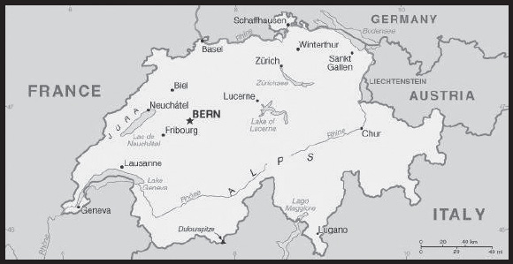
INTRODUCTION
Background: The Swiss Confederation was founded in 1291 as a defensive alliance among three cantons. In succeeding years, other localities joined the original three. The Swiss Confederation secured its independence from the Holy Roman Empire in 1499. A constitution of 1848, subsequently modified in 1874 to allow voters to introduce referenda on proposed laws, replaced the confederation with a centralized federal government. Switzerland’s sovereignty and neutrality have long been honored by the major European powers, and the country was not involved in either of the two World Wars. The political and economic integration of Europe over the past half century, as well as Switzerland’s role in many UN and international organizations, has strengthened Switzerland’s ties with its neighbors. However, the country did not officially become a UN member until 2002. Switzerland remains active in many UN and international organizations but retains a strong commitment to neutrality.
GEOGRAPHY
Location: Central Europe, east of France, north of Italy
Geographic coordinates: 47 00 N, 8 00 E
Map references: Europe
Area: total: 41,277 sq km
land: 39,997 sq km
water: 1,280 sq km
comparison ranking: total 135
Area - comparative: slightly less than twice the size of New Jersey
Land boundaries: total: 1,770 km
border countries (5): Austria 158 km; France 525 km; Italy 698 km; Liechtenstein 41 km; Germany 348 km
Coastline: 0 km (landlocked)
Maritime claims: none (landlocked)
Climate: temperate, but varies with altitude; cold, cloudy, rainy/snowy winters; cool to warm, cloudy, humid summers with occasional showers
Terrain: mostly mountains (Alps in south, Jura in northwest) with a central plateau of rolling hills, plains, and large lakes
Elevation: highest point: Dufourspitze 4,634 m
lowest point: Lake Maggiore 195 m
mean elevation: 1,350 m
Natural resources: hydropower potential, timber, salt
Land use: agricultural land: 38.7% (2018 est.)
arable land: 10.2% (2018 est.)
permanent crops: 0.6% (2018 est.)
permanent pasture: 27.9% (2018 est.)
forest: 31.5% (2018 est.)
other: 29.8% (2018 est.)
Irrigated land: 327 sq km (2016)
Major lakes (area sq km): fresh water lake(s): Lake Constance (shared with Germany and Austria) - 540 sq km; Lake Geneva (shared with France) - 580 sq km
Major rivers (by length in km): Rhein (Rhine) river source (shared with Germany, France, and Netherlands [m]) - 1,233 km
note – [s] after country name indicates river source; [m] after country name indicates river mouth
Major watersheds (area sq km): Atlantic Ocean drainage: Rhine-Maas (198,735 sq km), (Black Sea) Danube (795,656 sq km), (Adriatic Sea) Po (76,997 sq km), (Mediterranean Sea) Rhone (100,543 sq km)
Population distribution: population distribution corresponds to elevation with the northern and western areas far more heavily populated; the higher Alps of the south limit settlement
Natural hazards: avalanches, landslides; flash floods
Geography - note: landlocked; crossroads of northern and southern Europe; along with southeastern France, northern Italy, and southwestern Austria, has the highest elevations in the Alps
PEOPLE AND SOCIETY
Population: 8,563,760 (2023 est.)
comparison ranking: 102
Nationality: noun: Swiss (singular and plural)
adjective: Swiss
Ethnic groups: Swiss 69.2%, German 4.2%, Italian 3.2%, Portuguese 2.5%, French 2.1%, Kosovan 1.1%, Turkish 1%, other 16.7% (2020 est.)
note: data represent permanent and non-permanent resident population by country of birth
Languages: German (or Swiss German) (official) 62.1%, French (official) 22.8%, Italian (official) 8%, English 5.7%, Portuguese 3.5%, Albanian 3.3%, Serbo-Croatian 2.3%, Spanish 2.3%, Romansh (official) 0.5%, other 7.9%; note - German, French, Italian, and Romansh are all national and official languages; shares sum to more than 100% because respondents could indicate more than one main language (2019 est.)
major-language sample(s):
Das World Factbook, die unverzichtbare Quelle für grundlegende Informationen. (German)
The World Factbook, une source indispensable d’informations de base. (French)
L’Almanacco dei fatti del mondo, l’indispensabile fonte per le informazioni di base. (Italian)
Religions: Roman Catholic 34.4%, Protestant 22.5%, other Christian 5.7%, Muslim 5.4%, other 1.5%, none 29.4%, unspecified 1.1% (2020 est.)
Age structure: 0-14 years: 15.49% (male 683,053/female 643,067)
15-64 years: 65.13% (male 2,800,880/female 2,777,109)
65 years and over: 19.38% (2023 est.) (male 745,501/female 914,150)
Dependency ratios: total dependency ratio: 51.6
youth dependency ratio: 22.8
elderly dependency ratio: 28.7
potential support ratio: 3.5 (2021 est.)
Median age: total: 44 years (2023 est.)
male: 43.3 years
female: 44.8 years
comparison ranking: total 31
Population growth rate: 0.78% (2023 est.)
comparison ranking: 116
Birth rate: 10.2 births/1,000 population (2023 est.)
comparison ranking: 185
Death rate: 8.4 deaths/1,000 population (2023 est.)
comparison ranking: 75
Net migration rate: 6 migrant(s)/1,000 population (2023 est.)
comparison ranking: 18
Population distribution: population distribution corresponds to elevation with the northern and western areas far more heavily populated; the higher Alps of the south limit settlement
Urbanization: urban population: 74.2% of total population (2023)
rate of urbanization: 0.79% annual rate of change (2020-25 est.)
Major urban areas - population: 1.432 million Zurich, 441,000 BERN (capital) (2023)
Sex ratio: at birth: 1.05 male(s)/female
0-14 years: 1.06 male(s)/female
15-64 years: 1.01 male(s)/female
65 years and over: 0.82 male(s)/female
total population: 0.99 male(s)/female (2023 est.)
Mother’s mean age at first birth: 31.1 years (2020 est.)
Maternal mortality ratio: 7 deaths/100,000 live births (2020 est.)
comparison ranking: 154
Infant mortality rate: total: 3 deaths/1,000 live births (2023 est.)
male: 3.4 deaths/1,000 live births
female: 2.6 deaths/1,000 live births
comparison ranking: total 210
Life expectancy at birth: total population: 83.8 years (2023 est.)
male: 81.9 years
female: 85.8 years
comparison ranking: total population 7
Total fertility rate: 1.59 children born/woman (2023 est.)
comparison ranking: 186
Gross reproduction rate: 0.77 (2023 est.)
Contraceptive prevalence rate: 71.6% (2017)
Drinking water source: improved:
total: 100% of population
unimproved: total: 0% of population (2020 est.)
Current health expenditure: 11.8% of GDP (2020)
Physicians density: 4.38 physicians/1,000 population (2020)
Hospital bed density: 4.6 beds/1,000 population (2018)
Sanitation facility access: improved:
total: 100% of population
unimproved: total: 0% of population (2020 est.)
Obesity - adult prevalence rate: 19.5% (2016)
comparison ranking: 112
Alcohol consumption per capita: total: 9.41 liters of pure alcohol (2019 est.)
beer: 3.17 liters of pure alcohol (2019 est.)
wine: 4.35 liters of pure alcohol (2019 est.)
spirits: 1.76 liters of pure alcohol (2019 est.)
other alcohols: 0.12 liters of pure alcohol (2019 est.)
comparison ranking: total 30
Tobacco use: total: 25.5% (2020 est.)
male: 28.1% (2020 est.)
female: 22.9% (2020 est.)
comparison ranking: total 46
Currently married women (ages 15-49): 57.5% (2023 est.)
Education expenditures: 5.2% of GDP (2020 est.)
comparison ranking: 68
School life expectancy (primary to tertiary education): total: 17 years
male: 17 years
female: 17 years (2020)
Youth unemployment rate (ages 15-24): total: 9.1% (2021 est.)
male: 9.4%
female: 8.8%
comparison ranking: total 163
ENVIRONMENT
Environment - current issues: air pollution from vehicle emissions; water pollution from agricultural fertilizers; chemical contaminants and erosion damage the soil and limit productivity; loss of biodiversity
Environment - international agreements: party to: Air Pollution, Air Pollution-Heavy Metals, Air Pollution-Multi-effect Protocol, Air Pollution-Nitrogen Oxides, Air Pollution-Persistent Organic Pollutants, Air Pollution-Sulphur 85, Air Pollution-Sulphur 94, Air Pollution-Volatile Organic Compounds, Antarctic-Environmental Protection, Antarctic Treaty, Biodiversity, Climate Change, Climate Change-Kyoto Protocol, Climate Change-Paris Agreement, Comprehensive Nuclear Test Ban, Desertification, Endangered Species, Environmental Modification, Hazardous Wastes, Law of the Sea, Marine Dumping-London Convention, Marine Dumping-London Protocol, Marine Life Conservation, Nuclear Test Ban, Ozone Layer Protection, Ship Pollution, Tropical Timber 2006, Wetlands, Whaling
signed, but not ratified: none of the selected agreements
Climate: temperate, but varies with altitude; cold, cloudy, rainy/snowy winters; cool to warm, cloudy, humid summers with occasional showers
Land use: agricultural land: 38.7% (2018 est.)
arable land: 10.2% (2018 est.)
permanent crops: 0.6% (2018 est.)
permanent pasture: 27.9% (2018 est.)
forest: 31.5% (2018 est.)
other: 29.8% (2018 est.)
Urbanization: urban population: 74.2% of total population (2023)
rate of urbanization: 0.79% annual rate of change (2020-25 est.)
Revenue from forest resources: 0.01% of GDP (2018 est.)
comparison ranking: 151
Revenue from coal: 0% of GDP (2018 est.)
comparison ranking: 164
Air pollutants: particulate matter emissions: 8.97 micrograms per cubic meter (2019 est.)
carbon dioxide emissions: 34.48 megatons (2016 est.)
methane emissions: 4.98 megatons (2020 est.)
Waste and recycling: municipal solid waste generated annually: 6.056 million tons (2016 est.)
municipal solid waste recycled annually: 1.938 million tons (2015 est.)
percent of municipal solid waste recycled: 32% (2015 est.)
Major lakes (area sq km): fresh water lake(s): Lake Constance (shared with Germany and Austria) - 540 sq km; Lake Geneva (shared with France) - 580 sq km
Major rivers (by length in km): Rhein (Rhine) river source (shared with Germany, France, and Netherlands [m]) - 1,233 km
note – [s] after country name indicates river source; [m] after country name indicates river mouth
Major watersheds (area sq km): Atlantic Ocean drainage: Rhine-Maas (198,735 sq km), (Black Sea) Danube (795,656 sq km), (Adriatic Sea) Po (76,997 sq km), (Mediterranean Sea) Rhone (100,543 sq km)
Total water withdrawal: municipal: 970 million cubic meters (2020 est.)
industrial: 640 million cubic meters (2020 est.)
agricultural: 160 million cubic meters (2020 est.)
Total renewable water resources: 53.5 billion cubic meters (2020 est.)
GOVERNMENT
Country name: conventional long form: Swiss Confederation
conventional short form: Switzerland
local long form: Schweizerische Eidgenossenschaft (German)/ Confederation Suisse (French)/ Confederazione Svizzera (Italian)/ Confederaziun Svizra (Romansh)
local short form: Schweiz (German)/ Suisse (French)/ Svizzera (Italian)/ Svizra (Romansh)
abbreviation: CH
etymology: name derives from the canton of Schwyz, one of the founding cantons of the Swiss Confederacy that formed in the late 13th century
Government type: federal republic (formally a confederation)
Capital: name: Bern
geographic coordinates: 46 55 N, 7 28 E
time difference: UTC+1 (6 hours ahead of Washington, DC, during Standard Time)
daylight saving time: +1hr, begins last Sunday in March; ends last Sunday in October
etymology: origin of the name is uncertain but may derive from a 2nd century B.C. Celtic place name, possibly “berna” meaning “cleft,” that was subsequently adopted by a Roman settlement
Administrative divisions: 26 cantons (cantons, singular - canton in French; cantoni, singular - cantone in Italian; Kantone, singular - Kanton in German); Aargau, Appenzell Ausserrhoden, Appenzell Innerrhoden, Basel-Landschaft, Basel-Stadt, Berne/Bern, Fribourg/Freiburg, Geneve (Geneva), Glarus, Graubuenden/Grigioni/Grischun, Jura, Luzern (Lucerne), Neuchatel, Nidwalden, Obwalden, Sankt Gallen, Schaffhausen, Schwyz, Solothurn, Thurgau, Ticino, Uri, Valais/Wallis, Vaud, Zug, Zuerich
note: the canton names are in the official language(s) of the canton with the exception of Geneve and Luzern, where the conventional names (Geneva and Lucerne) have been added in parentheses; 6 of the cantons - Appenzell Ausserrhoden, Appenzell Innerrhoden, Basel-Landschaft, Basel-Stadt, Nidwalden, Obwalden - are referred to as half cantons because they elect only one member (instead of two) to the Council of States and, in popular referendums where a majority of popular votes and a majority of cantonal votes are required, these 6 cantons only have a half vote
Independence: 1 August 1291 (founding of the Swiss Confederation)
National holiday: Founding of the Swiss Confederation in 1291; note - since 1 August 1891 celebrated as Swiss National Day
Constitution: history: previous 1848, 1874; latest adopted by referendum 18 April 1999, effective 1 January 2000
amendments: proposed by the two houses of the Federal Assembly or by petition of at least one hundred thousand voters (called the “federal popular initiative”); passage of proposals requires majority vote in a referendum; following drafting of an amendment by the Assembly, its passage requires approval by majority vote in a referendum and approval by the majority of cantons; amended many times, last in 2018
Legal system: civil law system; judicial review of legislative acts, except for federal decrees of a general obligatory character
International law organization participation: accepts compulsory ICJ jurisdiction with reservations; accepts ICCt jurisdiction
Citizenship: citizenship by birth: no
citizenship by descent only: at least one parent must be a citizen of Switzerland
dual citizenship recognized: yes
residency requirement for naturalization: 12 years including at least 3 of the last 5 years prior to application
Suffrage: 18 years of age; universal
Executive branch: chief of state: President of the Swiss Confederation Alain BERSET (since 1 January 2023); Vice President Viola AMHERD (since 1 January 2023); note - the Federal Council, comprised of 7 federal councillors, constitutes the federal government of Switzerland; council members rotate the 1-year term of federal president
head of government: President of the Swiss Confederation Alain BERSET (since 1 January 2023); Vice President Viola AMHERD (since 1 January 2023)
cabinet: Federal Council or Bundesrat (in German), Conseil Federal (in French), Consiglio Federale (in Italian) indirectly elected by the Federal Assembly for a 4-year term
elections/appointments: president and vice president elected by the Federal Assembly from among members of the Federal Council for a 1-year, non-consecutive term; election last held on 8 December 2022 (next to be held in December 2023)
election results:
2022: Alain BERSET elected president for 2023; Federal Assembly vote - Alain BERSET (SP) 140 OF 181; Viola AMHERD (The Center) elected vice president; Federal assembly vote - 207 of 223
2021: Ignazio CASSIS elected president for 2022; Federal Assembly vote - Ignazio CASSIS (FDP.The Liberals) 156 of 197 votes; Alain BERSET (SP) elected vice president; Federal Assembly vote - 158 of 204
Legislative branch: description: bicameral Federal Assembly or Bundesversammlung (in German), Assemblée Fédérale (in French), Assemblea Federale (in Italian) consists of:
Council of States or Ständerat (in German), Conseil des États (in French), Consiglio degli Stati (in Italian) (46 seats; members in two-seat constituencies representing cantons and single-seat constituencies representing half cantons directly elected by simple majority vote except Jura and Neuchatel cantons, which use list proportional representation vote; member term governed by cantonal law)
National Council or Nationalrat (in German), Conseil National (in French), Consiglio Nazionale (in Italian) (200 seats; 194 members in cantons directly elected by proportional representation vote and 6 in half cantons directly elected by simple majority vote; members serve 4-year terms)
elections:
Council of States - last held in most cantons on 22 October 2023 (each canton determines when the next election will be held)
National Council - last held on 22 October 2023 (next to be held on 31 October 2027)
election results:
Council of States - percent of vote by party - NA; seats by party - The Center 13, FDP.The Liberals 12, SP 9, SVP 6, Green Party 5, other 1; composition (as of 22 Oct 2023) - men 34, women 12, percent of women 26.1%
National Council - percent of vote by party - SVP 28.6%, SP 18%, The Center 14.6%, FDP.The Liberals 14.4%, Green Party 9.4%, GLP 7.2%, EDU 1.2, EDV/PEV 1.9%, MCR/MCG .5%, other 4%; seats by party - SVP 62, SP 41, The Center 29, FDP.The Liberals 28, Green Party 23, GLP 10, EDU 2, EDV/PEV 2, MCR/MCG 2, other 1; composition (as of mid-2023) - men 123, women 77, percent of women 38.5%; note - overall Federal Assembly percent of women 41.5%
Judicial branch: highest court(s): Federal Supreme Court (consists of 38 justices and 19 deputy justices organized into 7 divisions)
judge selection and term of office: judges elected by the Federal Assembly for 6-year terms; note - judges are affiliated with political parties and are elected according to linguistic and regional criteria in approximate proportion to the level of party representation in the Federal Assembly
subordinate courts: Federal Criminal Court (established in 2004); Federal Administrative Court (established in 2007); note - each of Switzerland’s 26 cantons has its own courts
Political parties and leaders: The Center (Die Mitte, Alleanza del Centro, Le Centre, Allianza dal Center) [Gerhard PFISTER] (merger of the Christian Democratic People’s Party and the Conservative Democratic Party)
Evangelical Peoples’ Party or EVP/PEV [Lilian STUDER]
Federal Democrats or EDU [Daniel FRISCHKNECH]
Geneva Citizens Movement or MCR/MCG [Ana ROCH]
Green Liberal Party (Gruenliberale Partei or GLP, Parti vert liberale or PVL, Partito Verde-Liberale or PVL, Partida Verde Liberale or PVL) [Jurg GROSSEN]
Green Party (Gruene Partei der Schweiz or Gruene, Parti Ecologiste Suisse or Les Verts, Partito Ecologista Svizzero or I Verdi, Partida Ecologica Svizra or La Verda) [Balthasar GLATTLI]
The Liberals or FDP.The Liberals (FDP.Die Liberalen, PLR.Les Liberaux-Radicaux, PLR.I Liberali, Ils Liberals) [Thierry BURKART]
Social Democratic Party (Sozialdemokratische Partei der Schweiz or SP, Parti Socialiste Suisse or PSS, Partito Socialista Svizzero or PSS, Partida Socialdemocratica de la Svizra or PSS) [Cedric WERMUTH and Mattea MEYER]
Swiss People’s Party (Schweizerische Volkspartei or SVP, Union Democratique du Centre or UDC, Unione Democratica di Centro or UDC, Uniun Democratica dal Center or UDC) [Marco CHIESA]
International organization participation: ADB (nonregional member), AfDB (nonregional member), Australia Group, BIS, CD, CE, CERN, EAPC, EBRD, EFTA, EITI (implementing country), ESA, FAO, FATF, G-10, IADB, IAEA, IBRD, ICAO, ICC (national committees), ICCt, ICRM, IDA, IEA, IFAD, IFC, IFRCS, IGAD (partners), ILO, IMF, IMO, IMSO, Interpol, IOC, IOM, IPU, ISO, ITSO, ITU, ITUC (NGOs), LAIA (observer), MIGA, MINUSMA, MONUSCO, NEA, NSG, OAS (observer), OECD, OIF, OPCW, OSCE, Pacific Alliance (observer), Paris Club, PCA, PFP, Schengen Convention, UN, UNCTAD, UNESCO, UNHCR, UNIDO, UNITAR, UNMISS, UNMOGIP, UNRWA, UNTSO, UNWTO, UPU, Wassenaar Arrangement, WCO, WHO, WIPO, WMO, WTO, ZC
Diplomatic representation in the US: chief of mission: Ambassador Jacques Henri PITTELOUD (since 16 September 2019)
chancery: 2900 Cathedral Ave NW, Washington, DC 20008
telephone: [1] (202) 745-7900
FAX: [1] (202) 387-2564
email address and website:
https://www.eda.admin.ch/washington
consulate(s) general: Atlanta, Chicago, New York, San Francisco
consulate(s): Boston
Diplomatic representation from the US: chief of mission: Ambassador Scott C. MILLER (since 11 January 2022) note - also accredited to Liechtenstein
embassy: Sulgeneckstrasse 19, CH-3007 Bern
mailing address: 5110 Bern Place, Washington DC 20521-5110
telephone: [41] (031) 357-70-11
FAX: [41] (031) 357-73-20
email address and website:
Flag description: red square with a bold, equilateral white cross in the center that does not extend to the edges of the flag; various medieval legends purport to describe the origin of the flag; a white cross used as identification for troops of the Swiss Confederation is first attested at the Battle of Laupen (1339)
note: in 1863, a newly formed international relief organization convening in Geneva, Switzerland sought to come up with an identifying flag or logo; they chose the inverse of the Swiss flag - a red cross on a white field - as their symbol; today that organization is known throughout the world as the International Red Cross
National symbol(s): Swiss cross (white cross on red field, arms equal length); national colors: red, white
National anthem: name: the Swiss anthem has four names: “Schweizerpsalm” [German] “Cantique Suisse” [French] “Salmo svizzero,” [Italian] “Psalm svizzer” [Romansch] (Swiss Psalm)
lyrics/music: Leonhard WIDMER [German], Charles CHATELANAT [French], Camillo VALSANGIACOMO [Italian], and Flurin CAMATHIAS [Romansch]/Alberik ZWYSSIG
note: unofficially adopted 1961, officially 1981; the anthem has been popular in a number of Swiss cantons since its composition (in German) in 1841; translated into the other three official languages of the country (French, Italian, and Romansch), it is official in each of those languages
National heritage: total World Heritage Sites: 13 (9 cultural, 4 natural)
selected World Heritage Site locales: Old City of Berne (c); Swiss Alps Jungfrau-Aletsch (n); Monte San Giorgio (n); Abbey of St Gall (c); Three Castles, Defensive Wall, and Ramparts of the Market-Town of Bellinzona (c); Rhaetian Railway in the Albula/Bernina Landscapes (c); La Chaux-de-Fonds/Le Locle, Watchmaking Town Planning (c); Prehistoric Pile Dwellings around the Alps (c); Benedictine Convent of St John at Müstair (c); Lavaux, Vineyard Terraces (c)
ECONOMY
Economic overview: high-income, non-EU European economy; renowned banking and financial hub; extremely low unemployment; highly skilled but aging workforce; key pharmaceutical and precision manufacturing exporter; fairly high public debt
Real GDP (purchasing power parity): $618.228 billion (2021 est.)
$593.185 billion (2020 est.)
$607.619 billion (2019 est.)
note: data are in 2017 dollars
comparison ranking: 35
Real GDP growth rate: 4.22% (2021 est.)
-2.38% (2020 est.)
1.14% (2019 est.)
comparison ranking: 114
Real GDP per capita: $71,000 (2021 est.)
$68,700 (2020 est.)
$70,900 (2019 est.)
note: data are in 2017 dollars
comparison ranking: 9
GDP (official exchange rate): $731.502 billion (2019 est.)
Inflation rate (consumer prices): 0.58% (2021 est.)
-0.73% (2020 est.)
0.36% (2019 est.)
comparison ranking: 206
Credit ratings: Fitch rating: AAA (2000)
Moody’s rating: Aaa (1982)
Standard & Poors rating: AAA (1988)
note: The year refers to the year in which the current credit rating was first obtained.
GDP - composition, by sector of origin: agriculture: 0.7% (2017 est.)
industry: 25.6% (2017 est.)
services: 73.7% (2017 est.)
comparison rankings: services 54; industry 108; agriculture 206
GDP - composition, by end use: household consumption: 53.7% (2017 est.)
government consumption: 12% (2017 est.)
investment in fixed capital: 24.5% (2017 est.)
investment in inventories: -1.4% (2017 est.)
exports of goods and services: 65.1% (2017 est.)
imports of goods and services: -54% (2017 est.)
Agricultural products: milk, sugar beet, wheat, potatoes, pork, barley, apples, maize, beef, grapes
Industries: machinery, chemicals, watches, textiles, precision instruments, tourism, banking, insurance, pharmaceuticals
Industrial production growth rate: 7.91% (2021 est.)
comparison ranking: 52
Labor force: 4.963 million (2021 est.)
comparison ranking: 85
Labor force - by occupation: agriculture: 3.3%
industry: 19.8%
services: 76.9% (2015)
Unemployment rate: 5.32% (2021 est.)
4.82% (2020 est.)
4.39% (2019 est.)
comparison ranking: 140
Youth unemployment rate (ages 15-24): total: 9.1% (2021 est.)
male: 9.4%
female: 8.8%
comparison ranking: total 163
Population below poverty line: 16% (2018 est.)
Gini Index coefficient - distribution of family income: 33.1 (2018 est.)
comparison ranking: 123
Average household expenditures: on food: 9.2% of household expenditures (2018 est.)
on alcohol and tobacco: 3.6% of household expenditures (2018 est.)
Household income or consumption by percentage share: lowest 10%: 7.5%
highest 10%: 19% (2007)
Budget: revenues: $239.767 billion (2018 est.)
expenditures: $230.383 billion (2018 est.)
note: includes federal, cantonal, and municipal budgets
Budget surplus (+) or deficit (-): 1.1% (of GDP) (2017 est.)
comparison ranking: 31
Public debt: 20.91% of GDP (2020 est.)
18.95% of GDP (2019 est.)
18.68% of GDP (2018 est.)
note: general government gross debt; gross debt consists of all liabilities that require payment or payments of interest and/or principal by the debtor to the creditor at a date or dates in the future; includes debt liabilities in the form of Special Drawing Rights, currency and deposits, debt securities, loans, insurance, pensions and standardized guarantee schemes, and other accounts payable; all liabilities in the Government Financial Systems Manual 2001 system are debt, except for equity and investment fund shares and financial derivatives and employee stock options
comparison ranking: 188
Taxes and other revenues: 9.37% (of GDP) (2020 est.)
comparison ranking: 198
Fiscal year: calendar year
Current account balance: $59.159 billion (2021 est.)
$11.067 billion (2020 est.)
$30.806 billion (2019 est.)
comparison ranking: 12
Exports: $571.376 billion (2021 est.) ; note - data are in current year dollars
$474.236 billion (2020 est.) ; note - data are in current year dollars
$478.505 billion (2019 est.) ; note - data are in current year dollars
note: trade data exclude trade with Switzerland
comparison ranking: 15
Exports - partners: Germany 16%, United States 14%, United Kingdom 8%, China 7%, France 6%, India 6%, Italy 5% (2019)
Exports - commodities: gold, packaged medicines, medical cultures/vaccines, watches, jewelry (2019)
Imports: $480.522 billion (2021 est.) ; note - data are in current year dollars
$429.979 billion (2020 est.) ; note - data are in current year dollars
$413.404 billion (2019 est.) ; note - data are in current year dollars
comparison ranking: 16
Imports - partners: Germany 21%, Italy 8%, France 6%, United States 6%, United Kingdom 5%, United Arab Emirates 5% (2019)
Imports - commodities: gold, packaged medicines, jewelry, cars, medical cultures/vaccines (2019)
Reserves of foreign exchange and gold: $1.11 trillion (31 December 2021 est.)
$1.083 trillion (31 December 2020 est.)
$854.929 billion (31 December 2019 est.)
comparison ranking: 3
Debt - external: $1.909 trillion (2019 est.)
$1.931 trillion (2018 est.)
comparison ranking: 14
Exchange rates: Swiss francs (CHF) per US dollar -
Exchange rates:
0.914 (2021 est.)
0.939 (2020 est.)
0.994 (2019 est.)
0.978 (2018 est.)
0.985 (2017 est.)
ENERGY
Electricity access: electrification - total population: 100% (2021)
Electricity: installed generating capacity: 22.921 million kW (2020 est.)
consumption: 56.407 billion kWh (2020 est.)
exports: 32.549 billion kWh (2020 est.)
imports: 26.988 billion kWh (2020 est.)
transmission/distribution losses: 4.19 billion kWh (2020 est.)
comparison rankings: transmission/distribution losses 53; imports 5; exports 5; consumption 48; installed generating capacity 41
Electricity generation sources: fossil fuels: 0.8% of total installed capacity (2020 est.)
nuclear: 34.2% of total installed capacity (2020 est.)
solar: 3.8% of total installed capacity (2020 est.)
wind: 0.2% of total installed capacity (2020 est.)
hydroelectricity: 56.3% of total installed capacity (2020 est.)
biomass and waste: 4.7% of total installed capacity (2020 est.)
Nuclear energy: Number of operational nuclear reactors: 4 (2023)
Number of nuclear reactors under construction: 0
Net capacity of operational nuclear reactors: 2.97GW (2023)
Percent of total electricity production: 28.8% (2021)
Percent of total energy produced: 34.2% (2021)
Number of nuclear reactors permanently shut down: 1
Coal: production: 0 metric tons (2020 est.)
consumption: 150,000 metric tons (2020 est.)
exports: 0 metric tons (2020 est.)
imports: 139,000 metric tons (2020 est.)
proven reserves: 0 metric tons (2019 est.)
Petroleum: total petroleum production: 300 bbl/day (2021 est.)
refined petroleum consumption: 220,000 bbl/day (2019 est.)
crude oil and lease condensate exports: 0 bbl/day (2018 est.)
crude oil and lease condensate imports: 60,900 bbl/day (2018 est.)
crude oil estimated reserves: 0 barrels (2021 est.)
Refined petroleum products - production: 61,550 bbl/day (2017 est.)
comparison ranking: 79
Refined petroleum products - exports: 7,345 bbl/day (2017 est.)
comparison ranking: 88
Refined petroleum products - imports: 165,100 bbl/day (2017 est.)
comparison ranking: 39
Natural gas: production: 0 cubic meters (2021 est.)
consumption: 3,616,169,000 cubic meters (2019 est.)
exports: 0 cubic meters (2021 est.)
imports: 3,577,884,000 cubic meters (2019 est.)
proven reserves: 0 cubic meters (2021 est.)
Carbon dioxide emissions: 38.739 million metric tonnes of CO2 (2019 est.)
from coal and metallurgical coke: 319,000 metric tonnes of CO2 (2019 est.)
from petroleum and other liquids: 31.494 million metric tonnes of CO2 (2019 est.)
from consumed natural gas: 6.926 million metric tonnes of CO2 (2019 est.)
comparison ranking: total emissions 66
Energy consumption per capita: 137.918 million Btu/person (2019 est.)
comparison ranking: 38
COMMUNICATIONS
Telephones - fixed lines: total subscriptions: 2,956,500 (2021 est.)
subscriptions per 100 inhabitants: 34 (2021 est.)
comparison ranking: total subscriptions 43
Telephones - mobile cellular: total subscriptions: 11,060,700 (2021 est.)
subscriptions per 100 inhabitants: 127 (2021 est.)
comparison ranking: total subscriptions 88
Telecommunication systems: general assessment: Switzerland has one of the highest broadband penetration rates within Europe, with a focus on services of at least 1Gb/s; this has been supported by sympathetic regulatory measures as well as by cooperative agreements between the main telcos, and with local utilities; fast fiber is complemented by 5G services reaching about 97% of the population by early 2021; together, these networks will soon enable the telcos to provide ultra-fast broadband services nationally, ahead of most other countries in the region; the competitive mobile market is served by three network operators and a small number of MVNOs; 5G services offered by the MNOs offer data rates of up to 2Gb/s, and although various cantons have called a halt to extensions of 5G, citing health concerns, the regulator and environment ministry have put in place measures aimed at ensuring that network roll outs can continue without disruption; with the migration of subscribers to LTE and 5G networks, the MNOs have been able to begin closing down their GSM networks and repurpose physical assets and spectrum; although not a member of the EU, the country’s economic integration has meant that its telecom market deregulation has followed the EU’s liberalization framework, including the recent regulations on international voice roaming; this report presents an analysis of Switzerland’s fixed-line telecom market, including an assessment of network infrastructure (2021)
domestic: fixed-line is 34 per 100 and mobile-cellular subscribership is 127 per 100 persons (2021)
international: country code - 41; satellite earth stations - 2 Intelsat (Atlantic Ocean and Indian Ocean)
Broadcast media: the publicly owned radio and TV broadcaster, Swiss Broadcasting Corporation (SRG/SSR), operates 8 national TV networks, 3 broadcasting in German, 3 in French, and 2 in Italian; private commercial TV stations broadcast regionally and locally; TV broadcasts from stations in Germany, Italy, and France are widely available via multi-channel cable and satellite TV services; SRG/SSR operates 17 radio stations that, along with private broadcasters, provide national to local coverage)
(2019)
Internet country code: .ch
Internet users: total: 8.352 million (2021 est.)
percent of population: 96% (2021 est.)
comparison ranking: total 71
Broadband - fixed subscriptions: total: 4,028,238 (2020 est.)
subscriptions per 100 inhabitants: 47 (2020 est.)
comparison ranking: total 38
TRANSPORTATION
National air transport system: number of registered air carriers: 6 (2020)
inventory of registered aircraft operated by air carriers: 179
annual passenger traffic on registered air carriers: 28,857,994 (2018)
annual freight traffic on registered air carriers: 1,841,310,000 (2018) mt-km
Civil aircraft registration country code prefix: HB
Airports: 63 (2021)
comparison ranking: total 78
Airports - with paved runways: 40
note: paved runways have a concrete or asphalt surface but not all have facilities for refueling, maintenance, or air traffic control; the length of a runway required for aircraft to safely operate depends on a number of factors including the type of aircraft, the takeoff weight (including passengers, cargo, and fuel), engine types, flap settings, landing speed, elevation of the airport, and average maximum daily air temperature; paved runways can reach a length of 5,000 m (16,000 ft.), but the “typical” length of a commercial airline runway is between 2,500-4,000 m (8,000-13,000 ft.)
Airports - with unpaved runways: 23
note: unpaved runways have a surface composition such as grass or packed earth and are most suited to the operation of light aircraft; unpaved runways are usually short, often less than 1,000 m (3,280 ft.) in length; airports with unpaved runways often lack facilities for refueling, maintenance, or air traffic control
Heliports: 2 (2021)
Pipelines: 1,800 km gas, 94 km oil (of which 60 are inactive), 17 km refined products (2017)
Railways: total: 5,296 km (2020) 5,296 km electrified; Switzerland remains the only country with a fully electrified network
comparison ranking: total 36
Roadways: total: 71,557 km (2017)
paved: 71,557 km (2017) (includes 1,458 of expressways)
comparison ranking: total 66
Waterways: 1,292 km (2010) (there are 1,227 km of waterways on lakes and rivers for public transport and 65 km on the Rhine River between Basel-Rheinfelden and Schaffhausen-Bodensee for commercial goods transport)
comparison ranking: 61
Merchant marine: total: 20 (2022)
by type: bulk carrier 16, general cargo 1, other 3 (includes Liechtenstein)
comparison ranking: total 147
Ports and terminals: river port(s): Basel (Rhine)
MILITARY AND SECURITY
Military and security forces: Swiss Armed Forces (aka Swiss Army or Schweizer Armee); Army (Heer; aka Land Forces), Swiss Air Force (Schweizer Luftwaffe) (2023)
note: the federal police maintain internal security and report to the Federal Department of Justice and Police, while the Armed Forces report to the Federal Department of Defense, Civil Protection, and Sport
Military expenditures: 0.7% of GDP (2022)
0.7% of GDP (2021)
0.7% of GDP (2020)
0.7% of GDP (2019)
0.7% of GDP (2018)
comparison ranking: 143
Military and security service personnel strengths: the Swiss Armed Forces maintain a full-time professional cadre of about 4,000 personnel along with approximately 18-20,000 conscripts brought in annually for 18-23 weeks of training; approximately 120,000 reserve forces (2022)
Military equipment inventories and acquisitions: the military’s inventory includes a mix of domestically produced and imported weapons systems; in recent years, the US has been the leading supplier of military armaments to Switzerland; the Swiss defense industry produces a range of military land vehicles (2023)
Military service age and obligation: 18-30 years of age for compulsory military service for men; 18 years of age for voluntary military service for men and women; every Swiss male has to serve at least 245 days in the armed forces; conscripts receive 18 weeks of mandatory training, followed by six 19-day intermittent recalls for training during the next 10 years (2023)
note: conscientious objectors can choose 390 days of community service instead of military service; as of 2022, women comprised about 1% of the active Swiss military
Military deployments: up to 165 Kosovo (NATO/KFOR) (2023)
Military - note: the Swiss military is responsible for territorial defense, limited support to international disaster response and peacekeeping, and providing support to civil authorities when their resources are not sufficient to ward off threats to internal security or provide sufficient relief during disasters; Switzerland has long maintained a policy of military neutrality but does periodically participate in EU, NATO, Organization for Security and Cooperation in Europe (OSCE), and UN military and peacekeeping operations; however, Swiss units will only participate in operations under the mandate of the UN or OSCE; Switzerland joined NATO’s Partnership for Peace program in 1996; it contributed to the NATO-led Kosovo force (KFOR) in 1999 and, as of 2023, continued doing so with up to 165 personnel
the military is led by the Chief of the Armed Forces with an Armed Forces Staff and consists of a Joint Operations Command (JOC), an Armed Forces Logistics Organization, an Armed Forces Command Support Organization, and a Training and Education Command; the JOC controls, among other subordinate commands, the Air Force, the Land Forces, four territorial divisions, the Military Police Command, and the Special Forces Command; it is comprised of conscripts, militia, and a small professional component; the primary combat forces of the Army/Land Forces are three mechanized brigades, plus additional reserve brigades of armor, infantry, and mountain infantry forces; the four territorial divisions link the Army with the cantons; the Air Force is responsible for airspace protection (air sovereignty and air defense, including ground-based air defense), air transport, and airborne intelligence; it has about 50 US-origin multirole fighter aircraft (2023)
SPACE
Space agency/agencies: Switzerland does not have its own national space agency; it does most of its research and development within the framework of the European Space Agency’s (ESA) activities and programs; the Swiss Space Office, under the State Secretariat for Education, Research, and Innovation (SERI), is the government body responsible for space matters, including implementing national space policy, coordinating space activities, serving as the government point of contact for space industry and scientific institutions, and representation with the ESA and other international partners; the Federal Commission on Space Affairs provides advice and recommendations to the Federal Council on space matters; the Committee on Space Research of the Swiss Academy of Sciences coordinates and stimulates space research in Switzerland (2023)
Space program overview: space program integrated within the ESA framework; manufactures satellites and satellite payloads and products/components for satellite launch vehicles, satellites (particularly remote sensing, navigational, and telecommunications), and ground stations, including electronics, fairings, laser and fiber optics, sensor and nano technologies, scientific instruments, and software; produces atomic clocks (for navigational needs); has a considerable space research effort and has provided scientific instruments for a range of ESA and other space programs; participates in international space programs such as the International Space Station; has relations with a range of foreign space agencies and industries, including those of China, ESA and EU member states, Japan, and the US; the Swiss space industry is spread across approximately 100 businesses, most of which provide niche capabilities and supplies to large space companies (2023)
note: further details about the key activities, programs, and milestones of the country’s space program, as well as government spending estimates on the space sector, appear in Appendix S
TERRORISM
Terrorist group(s): Terrorist group(s): Islamic State of Iraq and ash-Sham (ISIS)
note: details about the history, aims, leadership, organization, areas of operation, tactics, targets, weapons, size, and sources of support of the group(s) appear(s) in Appendix-T
TRANSNATIONAL ISSUES
Disputes - international: none identified
Refugees and internally displaced persons: refugees (country of origin): 14,726 (Eritrea), 11,441 (Afghanistan), 8,039 (Syria), (mid-year 2022); 66,065 (Ukraine) (as of 22 September 2023)
stateless persons: 891 (2022)
Illicit drugs: major source of precursor chemicals used in the production of illicit narcotics; a significant importer and exporter of ephedrine and pseudoephedrine;
SYRIA
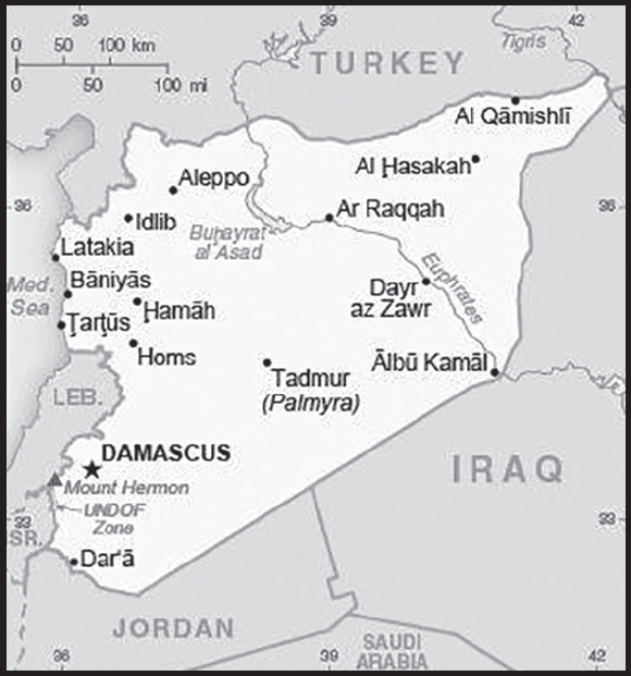
INTRODUCTION
Background: Following World War I, France acquired a mandate over the northern portion of the former Ottoman Empire province of Syria. The French administered the area as Syria until granting it independence in 1946. The new country lacked political stability and experienced a series of military coups. Syria united with Egypt in February 1958 to form the United Arab Republic. In September 1961, the two entities separated, and the Syrian Arab Republic was reestablished. In the 1967 Arab-Israeli War, Syria lost the Golan Heights region to Israel. During the 1990s, Syria and Israel held occasional, albeit unsuccessful, peace talks over its return. In November 1970, Hafiz al-ASAD, a member of the socialist Ba’ath Party and the minority Alawi sect, seized power in a bloodless coup and brought political stability to the country. Following the death of President Hafiz al-ASAD, his son, Bashar al-ASAD, was approved as president by popular referendum in July 2000. Syrian troops - stationed in Lebanon since 1976 in an ostensible peacekeeping role - were withdrawn in April 2005. During the July-August 2006 conflict between Israel and Hizballah, Syria placed its military forces on alert but did not intervene directly on behalf of its ally Hizballah. In May 2007, Bashar al-ASAD’s second term as president was approved by popular referendum.
Influenced by major uprisings that began elsewhere in the region, and compounded by additional social and economic factors, antigovernment protests broke out first in the southern province of Dar’a in March 2011 with protesters calling for the repeal of the restrictive Emergency Law allowing arrests without charge, the legalization of political parties, and the removal of corrupt local officials. Demonstrations and violent unrest spread across Syria with the size and intensity of protests fluctuating. The government responded to unrest with a mix of concessions - including the repeal of the Emergency Law, new laws permitting new political parties, and liberalizing local and national elections - and with military force and detentions. The government’s efforts to quell unrest and armed opposition activity led to extended clashes and eventually civil war between government forces, their allies, and oppositionists.
International pressure on the ASAD regime intensified after late 2011, as the Arab League, the EU, Turkey, and the US expanded economic sanctions against the regime and those entities that support it. In December 2012, the Syrian National Coalition, was recognized by more than 130 countries as the sole legitimate representative of the Syrian people. In September 2015, Russia launched a military intervention on behalf of the ASAD regime, and domestic and foreign government-aligned forces recaptured swaths of territory from opposition forces, and eventually the country’s second largest city, Aleppo, in December 2016, shifting the conflict in the regime’s favor. With this foreign support, the regime also recaptured opposition strongholds in the Damascus suburbs and the southern province of Dar’a in 2018. The regime continued to periodically regain opposition held territory until early 2020 when Turkish firepower halted a regime advance and forced a stalemate between regime and opposition forces that has prevented any subsequent advances. The government lacks territorial control over much of the northeastern part of the country, which is dominated by the predominantly Kurdish Syrian Democratic Forces (SDF), and a smaller area dominated by Turkey. The SDF expanded its territorial hold beyond its traditional homelands, subsuming much of the northeast since 2014 as it battled the Islamic State of Iraq and Syria. Since 2016, Turkey has been engaged in northern Syria and has conducted three large-scale military operations to capture territory along Syria’s northern border in the provinces of Aleppo, Ar Raqqah, and Al Hasakah. Some opposition forces organized under the Turkish-backed Syrian National Army and Turkish forces have maintained control of northwestern Syria along the Turkish border with the Afrin area of Aleppo Province since 2018. In 2019, Turkey and its opposition allies occupied formerly SDF-controlled territory between the cities of Tall Abyad to Ra’s Al ‘Ayn along Syria’s northern border. The extremist organization Hay’at Tahrir al-Sham (formerly the Nusrah Front) in 2017 emerged as the predominate opposition force in Idlib Province, and still dominates an area also hosting additional Turkish forces. Negotiations between the government and opposition delegations at UN-sponsored Geneva conferences since 2014 and separately held discussions between Iran, Russia, and Turkey since early 2017 have failed to produce a resolution to the conflict. According to a September 2021 UN estimate, the death toll resulting from the past 10 years of civil war is more than 350,000, although the UN acknowledges that this is the minimum number of verifiable deaths and is an undercount. According to a June 2022 UN estimate, the death toll resulting from the past 10 plus years of civil war is more than 306,000. As of early 2022, approximately 6.66 million Syrians were internally displaced and 14.6 million people were in need of humanitarian assistance across the country. An additional 5.6 million Syrians were registered refugees in Turkey, Jordan, Iraq, Egypt, and North Africa. The conflict in Syria remains one of the two largest displacement crises worldwide (the other is the invasion of Ukraine).
GEOGRAPHY
Location: Middle East, bordering the Mediterranean Sea, between Lebanon and Turkey
Geographic coordinates: 35 00 N, 38 00 E
Map references: Middle East
Area: total: 187,437 sq km
land: 185,887 sq km
water: 1,550 sq km
note: includes 1,295 sq km of Israeli-occupied territory
comparison ranking: total 89
Area - comparative: slightly more than 1.5 times the size of Pennsylvania
Land boundaries: total: 2,363 km
border countries (5): Iraq 599 km; Israel 83 km; Jordan 379 km; Lebanon 403 km; Turkey 899 km
Coastline: 193 km
Maritime claims: territorial sea: 12 nm
contiguous zone: 24 nm
Climate: mostly desert; hot, dry, sunny summers (June to August) and mild, rainy winters (December to February) along coast; cold weather with snow or sleet periodically in Damascus
Terrain: primarily semiarid and desert plateau; narrow coastal plain; mountains in west
Elevation: highest point: Mount Hermon (Jabal a-Shayk) 2,814 m
lowest point: Yarmuk River -66 m
mean elevation: 514 m
Natural resources: petroleum, phosphates, chrome and manganese ores, asphalt, iron ore, rock salt, marble, gypsum, hydropower
Land use: agricultural land: 75.8% (2018 est.)
arable land: 25.4% (2018 est.)
permanent crops: 5.8% (2018 est.)
permanent pasture: 44.6% (2018 est.)
forest: 2.7% (2018 est.)
other: 21.5% (2018 est.)
Irrigated land: 13,100 sq km (2013)
Major rivers (by length in km): Euphrates (shared with Turkey [s], Iran, and Iraq [m]) - 3,596 km; Tigris (shared with Turkey, Iran, and Iraq [m]) - 1,950 km
note – [s] after country name indicates river source; [m] after country name indicates river mouth
Major watersheds (area sq km): Indian Ocean drainage: (Persian Gulf) Tigris and Euphrates (918,044 sq km)
Population distribution: significant population density along the Mediterranean coast; larger concentrations found in the major cities of Damascus, Aleppo (the country’s largest city), and Hims (Homs); more than half of the population lives in the coastal plain, the province of Halab, and the Euphrates River valley
note: the ongoing civil war has altered the population distribution
Natural hazards: dust storms, sandstorms
volcanism: Syria’s two historically active volcanoes, Es Safa and an unnamed volcano near the Turkish border have not erupted in centuries
Geography - note: the capital of Damascus - located at an oasis fed by the Barada River - is thought to be one of the world’s oldest continuously inhabited cities; there are 42 Israeli settlements and civilian land use sites in the Israeli-controlled Golan Heights (2017)
PEOPLE AND SOCIETY
Population: 22,933,531 (2023 est.)
note: approximately 22,900 Israeli settlers live in the Golan Heights (2018)
comparison ranking: 59
Nationality: noun: Syrian(s)
adjective: Syrian
Ethnic groups: Arab ~50%, Alawite ~15%, Kurd ~10%, Levantine ~10%, other ~15% (includes Druze, Ismaili, Imami, Nusairi, Assyrian, Turkoman, Armenian)
Languages: Arabic (official), Kurdish, Armenian, Aramaic, Circassian, French, English
major-language sample(s):

(Arabic)

(Kurdish)
Religions: Muslim 87% (official; includes Sunni 74% and Alawi, Ismaili, and Shia 13%), Christian 10% (includes Orthodox, Uniate, and Nestorian), Druze 3%
note: the Christian population may be considerably smaller as a result of Christians fleeing the country during the ongoing civil war
Age structure: 0-14 years: 33.27% (male 3,914,737/female 3,716,362)
15-64 years: 62.58% (male 7,141,423/female 7,209,386)
65 years and over: 4.15% (2023 est.) (male 445,288/female 506,335)
Dependency ratios: total dependency ratio: 55.4
youth dependency ratio: 53
elderly dependency ratio: 7.4
potential support ratio: 13.5 (2021 est.)
Median age: total: 23.9 years (2023 est.)
male: 23.3 years
female: 24.5 years
comparison ranking: total 176
Population growth rate: 6.39% (2023 est.)
comparison ranking: 1
Birth rate: 22.2 births/1,000 population (2023 est.)
comparison ranking: 57
Death rate: 4.1 deaths/1,000 population (2023 est.)
comparison ranking: 214
Net migration rate: 45.8 migrant(s)/1,000 population (2023 est.)
comparison ranking: 1
Population distribution: significant population density along the Mediterranean coast; larger concentrations found in the major cities of Damascus, Aleppo (the country’s largest city), and Hims (Homs); more than half of the population lives in the coastal plain, the province of Halab, and the Euphrates River valley
note: the ongoing civil war has altered the population distribution
Urbanization: urban population: 57.4% of total population (2023)
rate of urbanization: 5.38% annual rate of change (2020-25 est.)
Major urban areas - population: 2.585 million DAMASCUS (capital), 2.203 million Aleppo, 1.443 million Hims (Homs), 996,000 Hamah (2023)
Sex ratio: at birth: 1.06 male(s)/female
0-14 years: 1.05 male(s)/female
15-64 years: 0.99 male(s)/female
65 years and over: 0.88 male(s)/female
total population: 1.01 male(s)/female (2023 est.)
Maternal mortality ratio: 30 deaths/100,000 live births (2020 est.)
comparison ranking: 111
Infant mortality rate: total: 15.5 deaths/1,000 live births (2023 est.)
male: 17.1 deaths/1,000 live births
female: 13.8 deaths/1,000 live births
comparison ranking: total 92
Life expectancy at birth: total population: 74.6 years (2023 est.)
male: 73.1 years
female: 76.1 years
comparison ranking: total population 137
Total fertility rate: 2.74 children born/woman (2023 est.)
comparison ranking: 61
Gross reproduction rate: 1.33 (2023 est.)
Drinking water source: improved: urban: 99.6% of population
rural: 100% of population
total: 99.8% of population
unimproved: urban: 0.4% of population
rural: 0.7% of population
total: 0.2% of population (2020 est.)
Physicians density: 1.29 physicians/1,000 population (2016)
Hospital bed density: 1.4 beds/1,000 population (2017)
Sanitation facility access: improved:
total: 99.5% of population
unimproved: total: 0.5% of population (2020 est.)
Obesity - adult prevalence rate: 27.8% (2016)
comparison ranking: 35
Alcohol consumption per capita: total: 0.13 liters of pure alcohol (2019 est.)
beer: 0.02 liters of pure alcohol (2019 est.)
wine: 0 liters of pure alcohol (2019 est.)
spirits: 0.11 liters of pure alcohol (2019 est.)
other alcohols: 0 liters of pure alcohol (2019 est.)
comparison ranking: total 176
Currently married women (ages 15-49): 52.6% (2023 est.)
Literacy: definition: age 15 and over can read and write
total population: 86.4%
male: 91.7%
female: 81% (2015)
School life expectancy (primary to tertiary education): total: 9 years
male: 9 years
female: 9 years (2013)
Youth unemployment rate (ages 15-24): total: 26.2% (2021 est.)
male: 21.6%
female: 51.1%
comparison ranking: total 56
ENVIRONMENT
Environment - current issues: deforestation; overgrazing; soil erosion; desertification; depletion of water resources; water pollution from raw sewage and petroleum refining wastes; inadequate potable water
Environment - international agreements: party to: Biodiversity, Climate Change, Climate Change-Kyoto Protocol, Climate Change-Paris Agreement, Desertification, Endangered Species, Hazardous Wastes, Marine Dumping-London Convention, Nuclear Test Ban, Ozone Layer Protection, Ship Pollution, Wetlands
signed, but not ratified: Environmental Modification
Climate: mostly desert; hot, dry, sunny summers (June to August) and mild, rainy winters (December to February) along coast; cold weather with snow or sleet periodically in Damascus
Land use: agricultural land: 75.8% (2018 est.)
arable land: 25.4% (2018 est.)
permanent crops: 5.8% (2018 est.)
permanent pasture: 44.6% (2018 est.)
forest: 2.7% (2018 est.)
other: 21.5% (2018 est.)
Urbanization: urban population: 57.4% of total population (2023)
rate of urbanization: 5.38% annual rate of change (2020-25 est.)
Food insecurity: exceptional shortfall in aggregate food production/supplies: due to civil conflict and economic crisis - the latest available nationwide food security assessment estimated that about 12 million people, 60% of the overall population, were food insecure in 2021, a slight decline from 12.4 million in 2020, but 5 million more than at the end of 2019, mostly due to constrained livelihood opportunities and a rapidly worsening economy (2022)
Air pollutants: particulate matter emissions: 25.14 micrograms per cubic meter (2019 est.)
carbon dioxide emissions: 28.83 megatons (2016 est.)
methane emissions: 12.93 megatons (2020 est.)
Waste and recycling: municipal solid waste generated annually: 4.5 million tons (2009 est.)
municipal solid waste recycled annually: 112,500 tons (2010 est.)
percent of municipal solid waste recycled: 2.5% (2010 est.)
Major rivers (by length in km): Euphrates (shared with Turkey [s], Iran, and Iraq [m]) - 3,596 km; Tigris (shared with Turkey, Iran, and Iraq [m]) - 1,950 km
note – [s] after country name indicates river source; [m] after country name indicates river mouth
Major watersheds (area sq km): Indian Ocean drainage: (Persian Gulf) Tigris and Euphrates (918,044 sq km)
Total water withdrawal: municipal: 1.48 billion cubic meters (2020 est.)
industrial: 620 million cubic meters (2020 est.)
agricultural: 14.67 billion cubic meters (2020 est.)
Total renewable water resources: 16.8 billion cubic meters (2020 est.)
GOVERNMENT
Country name: conventional long form: Syrian Arab Republic
conventional short form: Syria
local long form: Al Jumhuriyah al Arabiyah as Suriyah
local short form: Suriyah
former: United Arab Republic (with Egypt)
etymology: name ultimately derived from the ancient Assyrians who dominated northern Mesopotamia, but whose reach also extended westward to the Levant; over time, the name came to be associated more with the western area
Government type: presidential republic; highly authoritarian regime
Capital: name: Damascus
geographic coordinates: 33 30 N, 36 18 E
time difference: UTC+2 (7 hours ahead of Washington, DC, during Standard Time)
daylight saving time: +1hr, begins midnight on the last Friday in March; ends at midnight on the last Friday in October
etymology: Damascus is a very old city; its earliest name, Temeseq, first appears in an Egyptian geographical list of the 15th century B.C., but the meaning is uncertain
Administrative divisions: 14 provinces (muhafazat, singular - muhafazah); Al Hasakah, Al Ladhiqiyah (Latakia), Al Qunaytirah, Ar Raqqah, As Suwayda’, Dar’a, Dayr az Zawr, Dimashq (Damascus), Halab (Aleppo), Hamah, Hims (Homs), Idlib, Rif Dimashq (Damascus Countryside), Tartus
Independence: 17 April 1946 (from League of Nations mandate under French administration)
National holiday: Independence Day (Evacuation Day), 17 April (1946); note - celebrates the leaving of the last French troops and the proclamation of full independence
Constitution: history: several previous; latest issued 15 February 2012, passed by referendum and effective 27 February 2012; note - UN-sponsored talks, which began in late 2019 between delegates from government and opposition forces to draft a new constitution; in March 2022, the 7th round of the Syrian Constitutional Committee ended in Geneva with no results
amendments: proposed by the president of the republic or by one third of the People’s Assembly members; following review by a special Assembly committee, passage requires at least three-quarters majority vote by the Assembly and approval by the president
Legal system: mixed legal system of civil and Islamic (sharia) law (for family courts)
International law organization participation: has not submitted an ICJ jurisdiction declaration; non-party state to the ICC
Citizenship: citizenship by birth: no
citizenship by descent only: the father must be a citizen of Syria; if the father is unknown or stateless, the mother must be a citizen of Syria
dual citizenship recognized: yes
residency requirement for naturalization: 10 years
Suffrage: 18 years of age; universal
Executive branch: chief of state: President Bashar al-ASAD (since 17 July 2000); Vice President Najah al-ATTAR (since 23 March 2006)
head of government: Prime Minister Hussein ARNOUS (since 30 August 2020); Deputy Prime Minister Ali Abdullah AYOUB (Lt. Gen.) (since 30 August 2020)
cabinet: Council of Ministers appointed by the president
elections/appointments: president directly elected by simple majority popular vote for a 7-year term (eligible for a second term); election last held on 26 May 2021 (next to be held in 2028); the president appoints the vice president, prime minister, and deputy prime minister
election results: Bashar al-ASAD elected president; percent of vote - Bashar al-ASAD (Ba’th Party) 95.2%, Mahmoud Ahmad MAREI (Democratic Arab Socialist Union) 3.3%, other1.5%
Legislative branch: description: unicameral People’s Assembly or Majlis al-Shaab (250 seats; members directly elected in multi-seat constituencies by simple majority preferential vote to serve 4-year terms)
elections: last held on 19 July 2020 (next to be held in 2024)
election results: percent of vote by party - NPF 80%, other 20%; seats by party - NPF 200, other 50; composition - men 222, women 28, percent of women 11.2%
Judicial branch: highest court(s): Court of Cassation (organized into civil, criminal, religious, and military divisions, each with 3 judges); Supreme Constitutional Court (consists of 7 members)
judge selection and term of office: Court of Cassation judges appointed by the Supreme Judicial Council (SJC), a judicial management body headed by the minister of justice with 7 members, including the national president; judge tenure NA; Supreme Constitutional Court judges nominated by the president and appointed by the SJC; judges serve 4-year renewable terms
subordinate courts: courts of first instance; magistrates’ courts; religious and military courts; Economic Security Court; Counterterrorism Court (established June 2012)
Political parties and leaders: legal parties/alliances:
Arab Socialist Ba’ath Party [Bashar al-ASAD, regional secretary]
Arab Socialist Renaissance (Ba’th) Party [President Bashar al-ASAD]
Arab Socialist Union of Syria or ASU [Safwan al-QUDSI]
Democratic Arab Socialist Union [Hassan Abdul AZIM, general secretary]
National Progressive Front or NPF [Bashar al-ASAD, Suleiman QADDAH] (alliance includes Arab Socialist Renaissance (Ba’th) Party, Socialist Unionist Democratic Party)
Socialist Unionist Party [Fayiz ISMAIL]
Socialist Unionist Democratic Party [Fadlallah Nasr al-DIN]
Syrian Communist Party (two branches) [Wissal Farha BAKDASH, Yusuf Rashid FAYSAL]
Syrian Social Nationalist Party or SSNP [Ali HAIDAR]
Unionist Socialist Party [Fayez ISMAIL]
major Kurdish political organizations:
Kurdish Democratic Union Party or PYD [Saleh MUSLIM, Asia ABDULLAH]
Kurdish National Council or KNC [Sa’ud MALA]
Self-Administration of Northeast Syria or SANES [Abd Hamid al-MAHBASH]
Syrian Democratic Council or SDC [Ilham AHMAD]
other: Syrian Democratic Party [Mustafa QALAAJI]
International organization participation: ABEDA, AFESD, AMF, CAEU, FAO, G-24, G-77, IAEA, IBRD, ICAO, ICC (national committees), ICRM, ICSID, IDA, IDB, IFAD, IFC, IFRCS, IHO, ILO, IMF, IMO, Interpol, IOC, IPU, ISO, ITSO, ITU, LAS, MIGA, NAM, OAPEC, OIC, OPCW, UN, UNCTAD, UNESCO, UNIDO, UNRWA, UNWTO, UPU, WBG, WCO, WFTU (NGOs), WHO, WIPO, WMO, WTO (observer)
Diplomatic representation in the US: chief of mission: Ambassador (vacant); note – embassy closed on 18 March 2014
chancery: 2215 Wyoming Avenue NW, Washington, DC 20008; note – embassy closed on 18 March 2014
Diplomatic representation from the US: chief of mission: Ambassador (vacant); note - on 6 February 2012, the US closed its embassy in Damascus; Czechia serves as a protecting power for US interests in Syria
mailing address: 6110 Damascus Place, Washington DC 20521-6110
email address and website:
Flag description: three equal horizontal bands of red (top), white, and black; two small, green, five-pointed stars in a horizontal line centered in the white band; the band colors derive from the Arab Liberation flag and represent oppression (black), overcome through bloody struggle (red), to be replaced by a bright future (white); identical to the former flag of the United Arab Republic (1958-1961) where the two stars represented the constituent states of Syria and Egypt; the current design dates to 1980
note: similar to the flag of Yemen, which has a plain white band; Iraq, which has an Arabic inscription centered in the white band; and that of Egypt, which has a gold Eagle of Saladin centered in the white band
National symbol(s): hawk; national colors: red, white, black, green
National anthem: name: “Humat ad-Diyar” (Guardians of the Homeland)
lyrics/music: Khalil Mardam BEY/Mohammad Salim FLAYFEL and Ahmad Salim FLAYFEL
note: adopted 1936, restored 1961; between 1958 and 1961, while Syria was a member of the United Arab Republic with Egypt, the country had a different anthem
National heritage: total World Heritage Sites: 6 (all cultural)
selected World Heritage Site locales: Ancient City of Damascus; Ancient City of Bosra; Site of Palmyra; Ancient City of Aleppo; Crac des Chevaliers and Qal’at Salah El-Din; Ancient Villages of Northern Syria
ECONOMY
Economic overview: low-income Middle Eastern economy; prior infrastructure and economy devastated by 11-year civil war; ongoing US sanctions; sporadic trans-migration during conflict; currently being supported by World Bank trust fund; ongoing hyperinflation
Real GDP (purchasing power parity): $50.28 billion (2015 est.)
$55.8 billion (2014 est.)
$61.9 billion (2013 est.)
note: data are in 2015 US dollars
the war-driven deterioration of the economy resulted in a disappearance of quality national level statistics in the 2012-13 period
comparison ranking: 114
Real GDP growth rate: -3.87% (2020 est.)
1.22% (2019 est.)
1.39% (2018 est.)
note: data are in 2015 dollars
comparison ranking: 210
Real GDP per capita: $2,900 (2015 est.)
$3,300 (2014 est.)
$2,800 (2013 est.)
note: data are in 2015 US dollars
comparison ranking: 198
GDP (official exchange rate): $24.6 billion (2014 est.)
Inflation rate (consumer prices): 28.1% (2017 est.)
47.3% (2016 est.)
comparison ranking: 9
GDP - composition, by sector of origin: agriculture: 20% (2017 est.)
industry: 19.5% (2017 est.)
services: 60.8% (2017 est.)
comparison rankings: services 117; industry 154; agriculture 48
GDP - composition, by end use: household consumption: 73.1% (2017 est.)
government consumption: 26% (2017 est.)
investment in fixed capital: 18.6% (2017 est.)
investment in inventories: 12.3% (2017 est.)
exports of goods and services: 16.1% (2017 est.)
imports of goods and services: -46.1% (2017 est.)
Agricultural products: wheat, barley, milk, olives, tomatoes, oranges, potatoes, sheep milk, lemons, limes
Industries: petroleum, textiles, food processing, beverages, tobacco, phosphate rock mining, cement, oil seeds crushing, automobile assembly
Industrial production growth rate: -14.77% (2020 est.)
comparison ranking: 204
Labor force: 6.143 million (2021 est.)
comparison ranking: 73
Labor force - by occupation: agriculture: 17%
industry: 16%
services: 67% (2008 est.)
Unemployment rate: 10.57% (2021 est.)
10.26% (2020 est.)
8.77% (2019 est.)
comparison ranking: 67
Youth unemployment rate (ages 15-24): total: 26.2% (2021 est.)
male: 21.6%
female: 51.1%
comparison ranking: total 56
Population below poverty line: 82.5% (2014 est.)
Budget: revenues: $1.162 billion (2017 est.)
expenditures: $3.211 billion (2017 est.)
note: government projections for FY2016
Budget surplus (+) or deficit (-): -8.7% (of GDP) (2017 est.)
comparison ranking: 203
Public debt: 94.8% of GDP (2017 est.)
91.3% of GDP (2016 est.)
comparison ranking: 31
Taxes and other revenues: 4.2% (of GDP) (2017 est.)
comparison ranking: 218
Fiscal year: calendar year
Current account balance: -$2.123 billion (2017 est.)
-$2.077 billion (2016 est.)
comparison ranking: 160
Exports: $1.85 billion (2017 est.)
$1.705 billion (2016 est.)
comparison ranking: 161
Exports - partners: Saudi Arabia 23%, Turkey 18%, Egypt 14%, United Arab Emirates 8%, Jordan 7%, Kuwait 5% (2019)
Exports - commodities: olive oil, cumin seeds, pistachios, tomatoes, apples, pears, spices, pitted fruits (2019)
Imports: $6.279 billion (2017 est.)
$5.496 billion (2016 est.)
comparison ranking: 132
Imports - partners: Turkey 27%, China 22%, United Arab Emirates 14%, Egypt 5% (2019)
Imports - commodities: cigarettes, broadcasting equipment, wheat flours, sunflower oil, refined petroleum (2019)
Reserves of foreign exchange and gold: $407.3 million (31 December 2017 est.)
$504.6 million (31 December 2016 est.)
comparison ranking: 170
Debt - external: $4.989 billion (31 December 2017 est.)
$5.085 billion (31 December 2016 est.)
comparison ranking: 133
Exchange rates: Syrian pounds (SYP) per US dollar -
Exchange rates:
514.6 (2017 est.)
459.2 (2016 est.)
459.2 (2015 est.)
236.41 (2014 est.)
153.695 (2013 est.)
ENERGY
Electricity access: population without electricity: (2020) 2 million
electrification - total population: 88.8% (2021)
electrification - urban areas: 100% (2021)
electrification - rural areas: 74.5% (2021)
Electricity: installed generating capacity: 10.082 million kW (2020 est.)
consumption: 13,071,080,000 kWh (2019 est.)
exports: 347 million kWh (2019 est.)
imports: 0 kWh (2019 est.)
transmission/distribution losses: 3.687 billion kWh (2019 est.)
comparison rankings: installed generating capacity 65; transmission/distribution losses 57; imports 150; exports 80; consumption 88
Electricity generation sources: fossil fuels: 95.1% of total installed capacity (2020 est.)
hydroelectricity: 4.8% of total installed capacity (2020 est.)
biomass and waste: 0.2% of total installed capacity (2020 est.)
Coal: production: 0 metric tons (2020 est.)
consumption: 38,000 metric tons (2020 est.)
exports: 0 metric tons (2020 est.)
imports: 38,000 metric tons (2020 est.)
proven reserves: 0 metric tons (2019 est.)
Petroleum: total petroleum production: 80,800 bbl/day (2021 est.)
refined petroleum consumption: 137,900 bbl/day (2019 est.)
crude oil and lease condensate exports: 0 bbl/day (2018 est.)
crude oil and lease condensate imports: 129,100 bbl/day (2018 est.)
crude oil estimated reserves: 2.5 billion barrels (2021 est.)
Refined petroleum products - production: 111,600 bbl/day (2015 est.)
comparison ranking: 66
Refined petroleum products - exports: 12,520 bbl/day (2015 est.)
comparison ranking: 79
Refined petroleum products - imports: 38,080 bbl/day (2015 est.)
comparison ranking: 92
Natural gas: production: 3,531,077,000 cubic meters (2019 est.)
consumption: 3,531,077,000 cubic meters (2019 est.)
proven reserves: 240.693 billion cubic meters (2021 est.)
Carbon dioxide emissions: 26.893 million metric tonnes of CO2 (2019 est.)
from coal and metallurgical coke: 46,000 metric tonnes of CO2 (2019 est.)
from petroleum and other liquids: 19.92 million metric tonnes of CO2 (2019 est.)
from consumed natural gas: 6.927 million metric tonnes of CO2 (2019 est.)
comparison ranking: total emissions 76
Energy consumption per capita: 24.567 million Btu/person (2019 est.)
comparison ranking: 130
COMMUNICATIONS
Telephones - fixed lines: total subscriptions: 2,821,171 (2021 est.)
subscriptions per 100 inhabitants: 13 (2021 est.)
comparison ranking: total subscriptions 46
Telephones - mobile cellular: total subscriptions: 16,990,714 (2021 est.)
subscriptions per 100 inhabitants: 80 (2021 est.)
comparison ranking: total subscriptions 65
Telecommunication systems: general assessment: the years of civil war and destruction to infrastructure continue to have a toll on the telecoms sector in Syria; although over the years the major mobile service providers have endeavored to restore and rebuild damaged networks, the operating environment has been difficult; following disputed demands for back taxes, MTN Group in August 2021 exited the country, after its majority stake had been transferred to judicial guardianship; this effectively meant that the mobile market became a monopoly; in February 2022 the regulator awarded a third mobile license following a process which had been ongoing for many years; telecommunication services in Syria are highly regulated; although urban areas can make use of the network built and maintained by the government-owned incumbent, many under served remote areas in the countryside are obliged to rely on satellite communications; the domestic and international fixed-line markets in Syria remain the monopoly of the STE, despite several initiatives over the years aimed at liberalizing the market; mobile broadband penetration in Syria is still quite low, despite quite a high population coverage of 3G networks and some deployment of LTE infrastructure; this may provide potential opportunities for growth once infrastructure and economic reconstruction efforts make headway, and civil issues subside (2022)
domestic: the number of fixed-line connections is 13 per 100; mobile-cellular service is 80 per 100 persons (2021)
international: country code - 963; landing points for the Aletar, BERYTAR and UGART submarine cable connections to Egypt, Lebanon, and Cyprus; satellite earth stations - 1 Intelsat (Indian Ocean) and 1 Intersputnik (Atlantic Ocean region); coaxial cable and microwave radio relay to Iraq, Jordan, Lebanon, and Turkey; participant in Medarabtel (2019)
Broadcast media: state-run TV and radio broadcast networks; state operates 2 TV networks and 5 satellite channels; roughly two-thirds of Syrian homes have a satellite dish providing access to foreign TV broadcasts; 3 state-run radio channels; first private radio station launched in 2005; private radio broadcasters prohibited from transmitting news or political content (2018)
Internet country code: .sy
Internet users: total: 8,492,468 (2022 est.)
percent of population: 46.6% (2022 est.)
comparison ranking: total 69
Broadband - fixed subscriptions: total: 1,549,356 (2020 est.)
subscriptions per 100 inhabitants: 9 (2020 est.)
comparison ranking: total 64
TRANSPORTATION
National air transport system: number of registered air carriers: 3 (2020)
inventory of registered aircraft operated by air carriers: 11
annual passenger traffic on registered air carriers: 17,896 (2018)
annual freight traffic on registered air carriers: 30,000 (2018) mt-km
Civil aircraft registration country code prefix: YK
Airports: 90 (2021)
comparison ranking: total 62
Airports - with paved runways: 29
note: paved runways have a concrete or asphalt surface but not all have facilities for refueling, maintenance, or air traffic control; the length of a runway required for aircraft to safely operate depends on a number of factors including the type of aircraft, the takeoff weight (including passengers, cargo, and fuel), engine types, flap settings, landing speed, elevation of the airport, and average maximum daily air temperature; paved runways can reach a length of 5,000 m (16,000 ft.), but the “typical” length of a commercial airline runway is between 2,500-4,000 m (8,000-13,000 ft.)
Airports - with unpaved runways: 61
note: unpaved runways have a surface composition such as grass or packed earth and are most suited to the operation of light aircraft; unpaved runways are usually short, often less than 1,000 m (3,280 ft.) in length; airports with unpaved runways often lack facilities for refueling, maintenance, or air traffic control
Heliports: 6 (2021)
Pipelines: 3,170 km gas, 2029 km oil (2013)
Railways: total: 2,052 km (2014)
standard gauge: 1,801 km (2014) 1.435-m gauge
narrow gauge: 251 km (2014) 1.050-m gauge
comparison ranking: total 73
Roadways: total: 69,873 km (2010)
paved: 63,060 km (2010)
unpaved: 6,813 km (2010)
comparison ranking: total 69
Waterways: 900 km (2011) (navigable but not economically significant)
comparison ranking: 75
Merchant marine: total: 22 (2022)
by type: bulk carrier 1, general cargo 8, other 13
comparison ranking: total 146
Ports and terminals: major seaport(s): Baniyas, Latakia, Tartus
MILITARY AND SECURITY
Military and security forces: Syrian Armed Forces: Syrian Arab Army (includes Republican Guard), Syrian Naval Forces, Syrian Air Forces, Syrian Air Defense Forces, National Defense Forces (NDF), and Local Defense Forces (LDF) (2023)
note: NDF and LDF are pro-government militia and auxiliary forces; some militia and auxiliary forces are backed by Iran; the Syrian military is also supported by the Russian armed forces, the Iran-affiliated Hizballah terrorist group, and Iran’s Islamic Revolutionary Guard Corps
Military expenditures: 6.5% of GDP (2019 est.)
6.7% of GDP (2018 est.)
6.8% of GDP (2017 est.)
6.9% of GDP (2016 est.)
7.2% of GDP (2015 est.)
comparison ranking: 2
Military and security service personnel strengths: current estimates not available; the Syrian Armed Forces (SAF) are rebuilding after suffering significant casualties and desertions since the start of the civil war in 2011; prior to the civil war, the SAF had approximately 300,000 troops, including 200-225,000 Army, plus about 300,000 reserve forces (2023)
note: pro-government militia and auxiliary forces probably number in the tens of thousands
Military equipment inventories and acquisitions: the SAF’s inventory is comprised mostly of older Russian and Soviet-era equipment; in recent years, Russia has supplied the majority of Syria’s imported weapons systems (2023)
Military service age and obligation: 18-42 years of age for compulsory and voluntary military service; conscript service obligation is 18 months; women are not conscripted but may volunteer to serve, including in combat arms (2023)
note 1: the military is comprised largely of conscripts
note 2: Syrian women have been serving in combat roles since 2013; in 2015, the Syrian military created an all-female commando brigade
Military - note: the UN Disengagement Observer Force (UNDOF) has operated in the Golan between Israel and Syria since 1974 to monitor the ceasefire following the 1973 Arab-Israeli War and supervise the areas of separation between the two countries; UNDOF has about 1,000 personnel
multiple actors are conducting military operations in Syria in support of the ASAD government or Syrian opposition forces, as well in pursuit of their own security goals, such counterterrorism; operations have included air strikes, direct ground combat, and sponsoring proxy forces, as well as providing non-lethal military support, including advisors, technicians, arms and equipment, funding, intelligence, and training:
pro-ASAD elements operating in Syria have included the Syrian Arab Army, Lebanese Hizbollah, Iranian, Iranian-backed Shia militia, and Russian forces; since early in the civil war, the ASAD government has relied on Lebanese Hizballah (see Appendix T for further information), as well as Iran and Iranian-backed irregular forces, for combat operations and to hold territory; since 2011, Iran has provided military advisors and combat troops from the Iranian Revolutionary Guard Corps (including the Qods Force; see Appendix T for further information), as well as intelligence, logistical, material, technical, and financial support; it has funded, trained, equipped, and led Shia militia/paramilitary units comprised of both Syrian and non-Syrian personnel, primarily from Afghanistan, Iraq, and Pakistan; Russia intervened at the request of the ASAD government in 2015 and has since provided air support, special operations forces, military advisors, private military contractors, training, arms, and equipment; Iranian and Russian support has also included assisting Syria in combating the Islamic State of Iraq and ash-Sham (ISIS; see Appendix T) terrorist group
Turkey has intervened militarily several times since 2016 to combat Kurdish militants and ISIS, support select Syrian opposition forces, and establish a buffer along portions of its border with Syria; Turkey continues to maintain a considerable military presence in northern Syria; it has armed and trained militia/proxy forces, such as the Syrian National Army, which was formed in late 2017 of Syrian Arab and Turkmen rebel factions in the Halab (Aleppo) province and northwestern Syria
the US and some regional and European states have at times backed Syrian opposition forces militarily and/or conducted military operations, primarily against ISIS; the US has operated in Syria since 2015 with ground forces and air strikes; the majority the US ground forces are deployed in the Eastern Syria Security Area (ESSA, which includes parts of Hasakah and Dayr az Zawr provinces east of the Euphrates River) in support of operations by the Syrian Democratic Forces against ISIS, while the remainder are in southeast Syria around At Tanf supporting counter-ISIS operations by the Syrian Free Army opposition force; the US has also conducted air strikes against Syrian military targets in response to Syrian Government use of chemical weapons against opposition forces and civilians; in addition, France, Jordan, Qatar, Saudi Arabia, and the UK have provided forms of military assistance to opposition forces and/or conducted operations against ISIS, including air strikes
Israel has conducted hundreds of military air strikes in Syria against Syrian military, Hizbollah, Iranian, and/or Iranian-backed militia targets
the Syrian Democratic Forces (SDF), a coalition of forces composed primarily of Kurdish, Sunni Arab, and Syriac Christian fighters; it is dominated and led by Kurdish forces, particularly the People’s Protection Units (YPG) militia; the SDF began to receive US support in 2015 and as of 2023 was the main local US partner in its counter-ISIS campaign; the SDF has internal security, counterterrorism, and commando units; Turkey views the SDF as an extension of the Kurdistan Workers’ Party (PKK), a US-designated terrorist organization (see Appendix T)
the ISIS terrorist group (see Appendix T) lost its last territorial stronghold to SDF forces in 2019, but continues to maintain a low-level insurgency; in addition, the SDF holds about 10,000 captured suspected ISIS fighters in detention facilities across northern Syria, including 2,000 from countries other than Iraq and Syria
the Hay’at Tahrir al-Sham (HTS; formerly known as al-Nusrah Front) terrorist organization (see Appendix T) is the dominant militant group in northwest Syria and asserted considerable influence and control over the so-called Syrian Salvation Government in the Iblib de-escalation zone and the Aleppo province (2023)
SPACE
Space agency/agencies: Syrian Space Agency (created in 2014); General Organization of Remote Sensing (GORS; established 1986 to replace the National Remote Sensing Center, established 1981) (2023)
Space program overview: status unclear; has been handicapped by the impact of the civil war, including the loss of students and scientists who fled the country; had previously focused on satellite development and related space technologies, as well as scientific research; has relations with the space agency and space industries of Russia (2023)
note: further details about the key activities, programs, and milestones of the country’s space program, as well as government spending estimates on the space sector, appear in Appendix S
TERRORISM
Terrorist group(s): Terrorist group(s): Abdallah Azzam Brigades; Ansar al-Islam; Asa’ib Ahl Al-Haq; Hizballah; Hurras al-Din; Islamic Jihad Union; Islamic Revolutionary Guard Corps (IRGC)/Qods Force; Islamic State of Iraq and ash-Sham (ISIS); Kata’ib Hizballah; Kurdistan Workers’ Party (PKK); Mujahidin Shura Council in the Environs of Jerusalem; al-Nusrah Front (Hay’at Tahrir al-Sham); al-Qa’ida; Palestine Liberation Front; Popular Front for the Liberation of Palestine (PFLP); PFLP-General Command
note: details about the history, aims, leadership, organization, areas of operation, tactics, targets, weapons, size, and sources of support of the group(s) appear(s) in Appendix-T
TRANSNATIONAL ISSUES
Disputes - international: Syria-Iraq: none identified
Syria-Israel: Golan Heights is Israeli-controlled with UN Disengagement Observer Force (UNDOF) patrolling a buffer zone since 1974; because of ceasefire violations and increased military activity in the Golan Heights, the UN Security Council continues to extend UNDOF’s mandate; since 2000, Lebanon has claimed Shab’a Farms in the Golan Heights
Syria-Jordan: the two countries signed an agreement in 2005 to settle the border dispute based on a 1931 demarcation accord; the two countries began demarcation in 2006
Syria-Lebanon: discussions on demarcating the two countries’ maritime borders were held in April 2021, after Syria signed a contract with a Russian company to conduct oil and gas exploration in a disputed maritime area, but the issue was not resolved
Syria-Turkey: none identified
Refugees and internally displaced persons: refugees (country of origin): 580,000 (Palestinian Refugees) (2022); 11,121 (Iraq) (2023)
IDPs: 6.865 million (ongoing civil war since 2011) (2022)
stateless persons: 160,000 (2022); note - Syria’s stateless population consists of Kurds and Palestinians; stateless persons are prevented from voting, owning land, holding certain jobs, receiving food subsidies or public healthcare, enrolling in public schools, or being legally married to Syrian citizens; in 1962, some 120,000 Syrian Kurds were stripped of their Syrian citizenship, rendering them and their descendants stateless; in 2011, the Syrian Government granted citizenship to thousands of Syrian Kurds as a means of appeasement; however, resolving the question of statelessness is not a priority given Syria’s ongoing civil war
note: the ongoing civil war has resulted in nearly 5.2 million registered Syrian refugees - dispersed mainly in Egypt, Iraq, Jordan, Lebanon, and Turkey - as of October 2023
Trafficking in persons: tier rating: Tier 3 — Syria does not fully meet the minimum standards for the elimination of trafficking and is not making significant efforts to do so, therefore Syria remained on Tier 3; during the reporting period, there was a government policy or pattern of human trafficking and employing or recruiting child soldiers; Syrians were exploited in forced labor under compulsory military service for indefinite periods under threat of torture, familial reprisal, or death; the government did not hold any traffickers criminally accountable nor identify or protect any victims; government and pro-Syrian militias continued to forcibly recruit and use child soldiers; the government did not prevent armed opposition forces and designated terrorist organizations from recruiting children; authorities continued to arrest, detain, and severely abuse trafficking victims, including child soldiers, and punished them for unlawful acts traffickers compelled them to commit (2022)
trafficking profile: human traffickers exploit domestic and foreign victims in Syria, as well as Syrians abroad; more than half of Syria’s pre-war population of 23 million have been internally displaced or are refugees in other countries and extremely vulnerable to traffickers; children are vulnerable to forced marriages, sexual slavery, and forced labor; armed groups, community members, and criminal gangs exploit women, girls, and boys in Syria in sex trafficking; Syrian government forces, pro-regime militias, and opposition forces use Syrian children in combat and support roles and as human shields; foreign domestic workers from Southeast Asian countries are subject to forced labor; terrorist groups reportedly force, coerce, or fraudulently recruit foreigners, including migrants from Central Asia and Western and other women, who are vulnerable to forced labor and sex trafficking; Syrian refugees in neighboring countries, particularly Jordan, Lebanon, Iraq, and Turkey, are highly vulnerable to sex trafficking and forced labor (2022)
Illicit drugs: increasing drug trafficking particularly the synthetic stimulant captagon, a mixture of various amphetamines, methamphetamine, and/or other stimulants; drug smuggling of captagon and other stimulants linked to the Syrian government and Hizballah