TIMOR-LESTE
INTRODUCTION
Background: The island of Timor was actively involved in Southeast Asian trading networks for centuries, and by the 14th century exported aromatic sandalwood, slaves, honey, and wax. A number of local chiefdoms ruled the island in the early 16th century when Portuguese traders arrived, chiefly attracted by the relative abundance of sandalwood on Timor; by mid-century, the Portuguese had colonized the island. Skirmishing with the Dutch in the region eventually resulted in an 1859 treaty in which Portugal ceded the western portion of the island. Imperial Japan occupied Portuguese Timor from 1942 to 1945, but Portugal resumed colonial authority after the Japanese defeat in World War II. East Timor declared itself independent from Portugal on 28 November 1975 and was invaded and occupied by Indonesian forces nine days later. It was incorporated into Indonesia in July 1976 as the province of Timor Timur (East Timor or Timor Leste). An unsuccessful campaign of pacification followed over the next two decades, during which an estimated 100,000 to 250,000 people died. In an August 1999 UN-supervised popular referendum, an overwhelming majority of the people of Timor-Leste voted for independence from Indonesia. However, in the next three weeks, anti-independence Timorese militias - organized and supported by the Indonesian military - commenced a large-scale, scorched-earth campaign of retribution. The militias killed approximately 1,400 Timorese and displaced nearly 500,000. Most of the country’s infrastructure, including homes, irrigation systems, water supply systems, and schools, and nearly all of the country’s electrical grid were destroyed. On 20 September 1999, Australian-led peacekeeping troops deployed to the country and brought the violence to an end. On 20 May 2002, Timor-Leste was internationally recognized as an independent state.
In 2006, internal tensions threatened the new nation’s security when a military strike led to violence and a breakdown of law and order. At Dili’s request, an Australian-led International Stabilization Force (ISF) deployed to Timor-Leste, and the UN Security Council established the UN Integrated Mission in Timor-Leste (UNMIT), which included an authorized police presence of over 1,600 personnel. The ISF and UNMIT restored stability, allowing for presidential and parliamentary elections in 2007 in a largely peaceful atmosphere. In 2008, rebels staged an unsuccessful attack against the president and prime minister. Since the attack, Timor-Leste has made considerable progress in building stability and democratic institutions, holding a series of successful parliamentary and presidential elections since 2012. Nonetheless, weak and unstable political coalitions have led to periodic episodes of political stalemate and crisis in governance. The ISF and UNMIT departed in 2012 but the UN continues to provide assistance on economic development and strengthening governing institutions. Currently, Timor-Leste is one of the world’s poorest nations with an economy that relies heavily on energy resources in the Timor Sea.
GEOGRAPHY
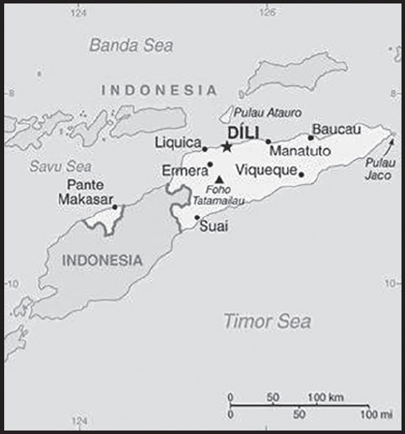
Location: Southeastern Asia, northwest of Australia in the Lesser Sunda Islands at the eastern end of the Indonesian archipelago; note - Timor-Leste includes the eastern half of the island of Timor, the Oecussi (Ambeno) region on the northwest portion of the island of Timor, and the islands of Pulau Atauro and Pulau Jaco
Geographic coordinates: 8 50 S, 125 55 E
Map references: Southeast Asia
Area: total: 14,874 sq km
land: 14,874 sq km
water: 0 sq km
comparison ranking: total 159
Area - comparative: slightly larger than Connecticut; almost half the size of Maryland
Land boundaries: total: 253 km
border countries (1): Indonesia 253 km
Coastline: 706 km
Maritime claims: territorial sea: 12 nm
contiguous zone: 24 nm
exclusive fishing zone: 200 nm
Climate: tropical; hot, humid; distinct rainy and dry seasons
Terrain: mountainous
Elevation: highest point: Foho Tatamailau 2,963 m
lowest point: Timor Sea, Savu Sea, and Banda Sea 0 m
Natural resources: gold, petroleum, natural gas, manganese, marble
Land use: agricultural land: 25.1% (2018 est.)
arable land: 10.1% (2018 est.)
permanent crops: 4.9% (2018 est.)
permanent pasture: 10.1% (2018 est.)
forest: 49.1% (2018 est.)
other: 25.8% (2018 est.)
Irrigated land: 350 sq km (2012)
Population distribution: most of the population concentrated in the western third of the country, particularly around Dili
Natural hazards: floods and landslides are common; earthquakes; tsunamis; tropical cyclones
Geography - note: Timor comes from the Malay word for “east”; the island of Timor is part of the Malay Archipelago and is the largest and easternmost of the Lesser Sunda Islands; the district of Oecussi is an exclave separated from Timor-Leste proper by Indonesia; Timor-Leste has the unique distinction of being the only Asian country located completely in the Southern Hemisphere
PEOPLE AND SOCIETY
Population: 1,476,042 (2023 est.)
comparison ranking: 156
Nationality: noun: Timorese
adjective: Timorese
Ethnic groups: Austronesian (Malayo-Polynesian) (includes Tetun, Mambai, Tokodede, Galoli, Kemak, Baikeno), Melanesian-Papuan (includes Bunak, Fataluku, Bakasai), small Chinese minority
Languages: Tetun Prasa 30.6%, Mambai 16.6%, Makasai 10.5%, Tetun Terik 6.1%, Baikenu 5.9%, Kemak 5.8%, Bunak 5.5%, Tokodede 4%, Fataluku 3.5%, Waima’a 1.8%, Galoli 1.4%, Naueti 1.4%, Idate 1.2%, Midiki 1.2%, other 4.5% (2015 est.)
note: data represent population by mother tongue; Tetun and Portuguese are official languages; Indonesian and English are working languages; there are about 32 indigenous languages
Religions: Roman Catholic 97.6%, Protestant/Evangelical 2%, Muslim 0.2%, other 0.2% (2015 est.)
Demographic profile: Timor-Leste’s high fertility and population growth rates sustain its very youthful age structure – approximately 40% of the population is below the age of 15 and the country’s median age is 20. While Timor-Leste’s total fertility rate (TFR) – the average number of births per woman – decreased significantly from over 7 in the early 2000s, it remains high at 4.3 in 2021 and will probably continue to decline slowly. The low use of contraceptives and the traditional preference for large families is keeping fertility elevated. The high TFR and falling mortality rates continue to fuel a high population growth rate of nearly 2.2%, which is the highest in Southeast Asia. The country’s high total dependency ratio – a measure of the ratio of dependents to the working-age population – could divert more government spending toward social programs. Timor-Leste’s growing, poorly educated working-age population and insufficient job creation are ongoing problems. Some 70% of the population lives in rural areas, where most of people are dependent on the agricultural sector. Malnutrition and poverty are prevalent, with 42% of the population living under the poverty line as of 2014.
During the Indonesian occupation (1975-1999) and Timor-Leste’s fight for independence, approximately 250,000 Timorese fled to western Timor and, in lesser numbers, Australia, Portugal, and other countries. Many of these emigrants later returned. Since Timor-Leste’s 1999 independence referendum, economic motives and periods of conflict have been the main drivers of emigration. Bilateral labor agreements with Australia, Malaysia, and South Korea and the presence of Timorese populations abroad, are pull factors, but the high cost prevents many young Timorese from emigrating. Timorese communities are found in its former colonizers, Indonesia and Portugal, as well as the Philippines and the UK. The country has also become a destination for migrants in the surrounding region, mainly men seeking work in construction, commerce, and services in Dili.
Age structure: 0-14 years: 39.05% (male 296,331/female 280,029)
15-64 years: 56.61% (male 408,662/female 426,897)
65 years and over: 4.34% (2023 est.) (male 30,856/female 33,267)
Dependency ratios: total dependency ratio: 90.3
youth dependency ratio: 59.4
elderly dependency ratio: 8.9
potential support ratio: 11.2 (2021 est.)
Median age: total: 20.3 years (2023 est.)
male: 19.6 years
female: 21.1 years
comparison ranking: total 199
Population growth rate: 2.1% (2023 est.)
comparison ranking: 39
Birth rate: 30.4 births/1,000 population (2023 est.)
comparison ranking: 26
Death rate: 5.6 deaths/1,000 population (2023 est.)
comparison ranking: 178
Net migration rate: -3.8 migrant(s)/1,000 population (2023 est.)
comparison ranking: 189
Population distribution: most of the population concentrated in the western third of the country, particularly around Dili
Urbanization: urban population: 32.5% of total population (2023)
rate of urbanization: 3.31% annual rate of change (2020-25 est.)
Major urban areas - population: 281,000 DILI (capital) (2018)
Sex ratio: at birth: 1.07 male(s)/female
0-14 years: 1.06 male(s)/female
15-64 years: 0.96 male(s)/female
65 years and over: 0.93 male(s)/female
total population: 0.99 male(s)/female (2023 est.)
Mother’s mean age at first birth: 23 years (2016 est.)
note: data represents median age at first birth among women 25-49
Maternal mortality ratio: 204 deaths/100,000 live births (2020 est.)
comparison ranking: 46
Infant mortality rate: total: 32.9 deaths/1,000 live births (2023 est.)
male: 36.1 deaths/1,000 live births
female: 29.5 deaths/1,000 live births
comparison ranking: total 42
Life expectancy at birth: total population: 70.2 years (2023 est.)
male: 68.6 years
female: 72 years
comparison ranking: total population 173
Total fertility rate: 4.09 children born/woman (2023 est.)
comparison ranking: 24
Gross reproduction rate: 1.98 (2023 est.)
Contraceptive prevalence rate: 26.1% (2016)
Drinking water source: improved: urban: 98% of population
rural: 82.5% of population
total: 87.4% of population
unimproved: urban: 2% of population
rural: 17.5% of population
total: 12.6% of population (2020 est.)
Current health expenditure: 9.9% of GDP (2020)
Physicians density: 0.76 physicians/1,000 population (2020)
Sanitation facility access: improved: urban: 88.7% of population
rural: 56.1% of population
total: 66.3% of population
unimproved: urban: 11.3% of population
rural: 43.9% of population
total: 33.7% of population (2020 est.)
Major infectious diseases: degree of risk: very high (2023)
food or waterborne diseases: bacterial diarrhea, hepatitis A, and typhoid fever
vectorborne diseases: dengue fever and malaria
Obesity - adult prevalence rate: 3.8% (2016)
comparison ranking: 190
Alcohol consumption per capita: total: 0.41 liters of pure alcohol (2019 est.)
beer: 0.27 liters of pure alcohol (2019 est.)
wine: 0.09 liters of pure alcohol (2019 est.)
spirits: 0.05 liters of pure alcohol (2019 est.)
other alcohols: 0 liters of pure alcohol (2019 est.)
comparison ranking: total 166
Tobacco use: total: 39.2% (2020 est.)
male: 67.6% (2020 est.)
female: 10.8% (2020 est.)
comparison ranking: total 6
Children under the age of 5 years underweight: 31.9% (2020)
comparison ranking: 4
Currently married women (ages 15-49): 55.9% (2023 est.)
Child marriage: women married by age 15: 2.6%
women married by age 18: 14.9%
men married by age 18: 1.2% (2016 est.)
Education expenditures: 4.2% of GDP (2020 est.)
comparison ranking: 109
Literacy: definition: age 15 and over can read and write
total population: 68.1%
male: 71.9%
female: 64.2% (2018)
Youth unemployment rate (ages 15-24): total: 13.8% (2021 est.)
male: 11.4%
female: 16.8%
comparison ranking: total 127
People - note: one of only two predominantly Christian nations in Southeast Asia, the other being the Philippines
ENVIRONMENT
Environment - current issues: air pollution and deterioration of air quality; greenhouse gas emissions; water quality, scarcity, and access; land and soil degradation; forest depletion; widespread use of slash and burn agriculture has led to deforestation and soil erosion; loss of biodiversity
Environment - international agreements: party to: Biodiversity, Climate Change, Climate Change-Kyoto Protocol, Climate Change-Paris Agreement, Desertification, Law of the Sea, Ozone Layer Protection
signed, but not ratified: Comprehensive Nuclear Test Ban
Climate: tropical; hot, humid; distinct rainy and dry seasons
Land use: agricultural land: 25.1% (2018 est.)
arable land: 10.1% (2018 est.)
permanent crops: 4.9% (2018 est.)
permanent pasture: 10.1% (2018 est.)
forest: 49.1% (2018 est.)
other: 25.8% (2018 est.)
Urbanization: urban population: 32.5% of total population (2023)
rate of urbanization: 3.31% annual rate of change (2020-25 est.)
Revenue from forest resources: 0.13% of GDP (2018 est.)
comparison ranking: 106
Revenue from coal: 0% of GDP (2018 est.)
comparison ranking: 143
Air pollutants: particulate matter emissions: 20.47 micrograms per cubic meter (2019 est.)
carbon dioxide emissions: 0.5 megatons (2016 est.)
methane emissions: 4.74 megatons (2020 est.)
Waste and recycling: municipal solid waste generated annually: 63,875 tons (2016 est.)
Total water withdrawal: municipal: 100 million cubic meters (2020 est.)
industrial: 2 million cubic meters (2017 est.)
agricultural: 1.07 billion cubic meters (2020 est.)
Total renewable water resources: 8.22 billion cubic meters (2020 est.)
GOVERNMENT
Country name: conventional long form: Democratic Republic of Timor-Leste
conventional short form: Timor-Leste
local long form: Republika Demokratika Timor Lorosa’e (Tetum)/ Republica Democratica de Timor-Leste (Portuguese)
local short form: Timor Lorosa’e (Tetum)/ Timor-Leste (Portuguese)
former: East Timor, Portuguese Timor
etymology: timor” derives from the Indonesian and Malay word “timur” meaning “east”; “leste” is the Portuguese word for “east”, so “Timor-Leste” literally means “Eastern-East”; the local [Tetum] name “Timor Lorosa’e” translates as “East Rising Sun”
note: pronounced TEE-mor LESS-tay
Government type: semi-presidential republic
Capital: name: Dili
geographic coordinates: 8 35 S, 125 36 E
time difference: UTC+9 (14 hours ahead of Washington, DC, during Standard Time)
Administrative divisions: 12 municipalities (municipios, singular municipio) and 1 special adminstrative region* (regiao administrativa especial); Aileu, Ainaro, Baucau, Bobonaro (Maliana), Covalima (Suai), Dili, Ermera (Gleno), Lautem (Lospalos), Liquica, Manatuto, Manufahi (Same), Oe-Cusse Ambeno* (Pante Macassar), Viqueque
note: administrative divisions have the same names as their administrative centers (exceptions have the administrative center name following in parentheses)
Independence: 20 May 2002 (from Indonesia); note - 28 November 1975 was the date independence was proclaimed from Portugal; 20 May 2002 was the date of international recognition of Timor-Leste’s independence from Indonesia
National holiday: Restoration of Independence Day, 20 May (2002); Proclamation of Independence Day, 28 November (1975)
Constitution: history: drafted 2001, approved 22 March 2002, entered into force 20 May 2002
amendments: proposed by Parliament and parliamentary groups; consideration of amendments requires at least four-fifths majority approval by Parliament; passage requires two-thirds majority vote by Parliament and promulgation by the president of the republic; passage of amendments to the republican form of government and the flag requires approval in a referendum
Legal system: civil law system based on the Portuguese model; note - penal and civil law codes to replace the Indonesian codes were passed by Parliament and promulgated in 2009 and 2011, respectively
International law organization participation: accepts compulsory ICJ jurisdiction with reservations; accepts ICCt jurisdiction
Citizenship: citizenship by birth: no
citizenship by descent only: at least one parent must be a citizen of Timor-Leste
dual citizenship recognized: no
residency requirement for naturalization: 10 years
Suffrage: 17 years of age; universal
Executive branch: chief of state: President José RAMOS-HORTA (since May 2022); note - the president is commander in chief of the military and can veto legislation, dissolve parliament, and call national elections
head of government: Prime Minister Kay Rala Xanana GUSMAO (since 1 July 2023)
cabinet: Council of Ministers; ministers proposed to the prime minister by the coalition in the Parliament and sworn in by the President of the Republic
elections/appointments: president directly elected by absolute majority popular vote in 2 rounds if needed for a 5-year term (eligible for a second term); last election held in April 2022 (next election to be held April 2027); following parliamentary elections, the president appoints the leader of the majority party or majority coalition as the prime minister
election results: 2022: José RAMOS-HORTA elected president in a runoff - RAMOS-HORTA (CNRT) 62.1%, Francisco GUTERRES (FRETILIN) 37.9%
2017: Francisco GUTERRES (FRETILIN) 57.1%, António da CONCEICAO (PD) 32.46%
Legislative branch: description: unicameral National Parliament (65 seats; members directly elected in a single nationwide constituency by closed, party-list proportional representation vote using the D’Hondt method to serve 5-year terms)
elections: last held May 2023 (next to be held in May 2028)
election results: percent of vote by party in 2023 elections - CNRT 41.5%, FRETILIN 25.8%, PD 9.3%, KHUNTO 7.5%, PLP 6%, other 9.9%; seats by party - CNRT 31, FRETILIN 19, PD 6, KHUNTO 5, PLP 4; note - 12 other parties received votes, but won no seats percent of vote by party in 2018 elections - AMP 49.6%, FRETILIN 34.2%, PD 8.1%, DDF 5.5%, other 2.6%; seats by party - AMP 34, FRETILIN 23, PD 5, DDF 3; composition - men 39, women 26, percent of women 40%; note - AMP (Alliance for Change and Progress) was a coalition of CNRT, PLP, and KHUNTO which dissolved in May of 2020
Judicial branch: highest court(s): Court of Appeals (consists of the court president and NA judges)
judge selection and term of office: court president appointed by the president of the republic from among the other court judges to serve a 4-year term; other court judges appointed - 1 by the Parliament and the others by the Supreme Council for the Judiciary, a body chaired by the court president and that includes mostly presidential and parliamentary appointees; other judges serve for life
subordinate courts: Court of Appeal; High Administrative, Tax, and Audit Court; district courts; magistrates’ courts; military courts
note: the UN Justice System Programme, launched in 2003 and being rolled out in 4 phases through 2018, is helping strengthen the country’s justice system; the Programme is aligned with the country’s long-range Justice Sector Strategic Plan, which includes legal reforms
Political parties and leaders: Democratic Party or PD [Mariano Assanami SABINO Lopes]
National Congress for Timorese Reconstruction or CNRT [Kay Rala Xanana GUSMAO]
National Unity of the Sons of Timor (Haburas Unidade Nasional Timor Oan or KHUNTO) [Armanda BERTA DOS SANTOS]
People’s Liberation Party or PLP [Taur Matan RUAK]
Revolutionary Front of Independent Timor-Leste or FRETILIN [Franciso GUTERRES]
note: 12 additional parties received votes during the 2023 parliamentary election but did not gain any seats
International organization participation: ACP, ADB, AOSIS, ARF, ASEAN (observer), CPLP, EITI (compliant country), FAO, G-77, IBRD, ICAO, ICCt, ICRM, IDA, IFAD, IFC, IFRCS, ILO, IMF, IMO, Interpol, IOC, IOM, IPU, ITU, MIGA, NAM, OPCW, PIF (observer), UN, UNCTAD, UNESCO, UNIDO, Union Latina, UNWTO, UPU, WCO, WHO, WMO
Diplomatic representation in the US: chief of mission: Ambassador (vacant); Chargé d’Affaires Antonito DE ARAUJO (since 24 February 2023)
chancery: 4201 Connecticut Avenue NW, Suite 504, Washington, DC 20008
telephone: [1] (202) 966-3202
FAX: [1] (202) 966-3205
email address and website: info@timorlesteembassy.org
http://www.timorlesteembassy.org/
Diplomatic representation from the US: chief of mission: Ambassador (vacant), Chargé d’Affaires Marc WEINSTOCK (since August 2023)
embassy: Avenida de Portugal, Praia dos Coqueiros, Dili
mailing address: 8250 Dili Place, Washington, DC 20521-8250
telephone: (670) 332-4684, (670) 330-2400
FAX: (670) 331-3206
email address and website: ConsDili@state.gov
Flag description: red with a black isosceles triangle (based on the hoist side) superimposed on a slightly longer yellow arrowhead that extends to the center of the flag; a white star - pointing to the upper hoist-side corner of the flag - is in the center of the black triangle; yellow denotes the colonialism in Timor-Leste’s past, black represents the obscurantism that needs to be overcome, red stands for the national liberation struggle; the white star symbolizes peace and serves as a guiding light
National symbol(s): Mount Ramelau; national colors: red, yellow, black, white
National anthem: name: “Patria” (Fatherland)
lyrics/music: Fransisco Borja DA COSTA/Afonso DE ARAUJO
note: adopted 2002; the song was first used as an anthem when Timor-Leste declared its independence from Portugal in 1975; the lyricist, Francisco Borja DA COSTA, was killed in the Indonesian invasion just days after independence was declared
ECONOMY
Economic overview: lower middle-income Southeast Asian economy; government expenditures funded via oil fund drawdowns; endemic corruption undermines growth; foreign aid-dependent; wide-scale poverty, unemployment, and illiteracy
Real GDP (purchasing power parity): $6.648 billion (2021 est.)
$6.313 billion (2020 est.)
$4.786 billion (2019 est.)
note: data are in 2017 dollars
comparison ranking: 172
Real GDP growth rate: 5.29% (2021 est.)
31.91% (2020 est.)
23.51% (2019 est.)
comparison ranking: 85
Real GDP per capita: $5,000 (2021 est.)
$4,900 (2020 est.)
$3,700 (2019 est.)
note: data are in 2017 dollars
comparison ranking: 176
GDP (official exchange rate): $2.775 billion (2017 est.)
note: non-oil GDP
Inflation rate (consumer prices): 0.96% (2019 est.)
2.29% (2018 est.)
0.52% (2017 est.)
comparison ranking: 202
GDP - composition, by sector of origin: agriculture: 9.1% (2017 est.)
industry: 56.7% (2017 est.)
services: 34.4% (2017 est.)
comparison rankings: services 220; industry 4; agriculture 95
GDP - composition, by end use: household consumption: 33% (2017 est.)
government consumption: 30% (2017 est.)
investment in fixed capital: 10.6% (2017 est.)
investment in inventories: 0% (2017 est.)
exports of goods and services: 78.4% (2017 est.)
imports of goods and services: -52% (2017 est.)
Agricultural products: rice, maize, vegetables, coffee, roots/tubers nes, other meats, cassava, pork, beans, mangoes/guavas
Industries: printing, soap manufacturing, handicrafts, woven cloth
Industrial production growth rate: 5.65% (2021 est.)
comparison ranking: 79
Labor force: 569,700 (2021 est.)
comparison ranking: 158
Labor force - by occupation: agriculture: 41%
industry: 13%
services: 45.1% (2013)
Unemployment rate: 5.07% (2021 est.)
4.91% (2020 est.)
4.51% (2019 est.)
comparison ranking: 149
Youth unemployment rate (ages 15-24): total: 13.8% (2021 est.)
male: 11.4%
female: 16.8%
comparison ranking: total 127
Population below poverty line: 41.8% (2014 est.)
Gini Index coefficient - distribution of family income: 28.7 (2014 est.)
comparison ranking: 160
Household income or consumption by percentage share: lowest 10%: 4%
highest 10%: 27% (2007)
Budget: revenues: $879 million (2019 est.)
expenditures: $1.396 billion (2019 est.)
Budget surplus (+) or deficit (-): -75.7% (of GDP) (2017 est.)
comparison ranking: 222
Public debt: 3.8% of GDP (2017 est.)
3.1% of GDP (2016 est.)
comparison ranking: 206
Taxes and other revenues: 22.86% (of GDP) (2019 est.)
comparison ranking: 65
Fiscal year: calendar year
Current account balance: $1.022 billion (2021 est.)
-$308.02 million (2020 est.)
$133.98 million (2019 est.)
comparison ranking: 50
Exports: $2.315 billion (2021 est.) note: data are in current year dollars
$57.105 million (2020 est.) note: data are in current year dollars
$117.472 million (2019 est.) note: data are in current year dollars
comparison ranking: 154
Exports - partners: Singapore 51%, China 20%, Japan 9%, Indonesia 6% (2019)
Exports - commodities: crude petroleum, natural gas, coffee, various vegetables, scrap iron (2019)
Imports: $1.523 billion (2021 est.) note: data are in current year dollars
$842 million (2020 est.) note: data are in current year dollars
$1.039 billion (2019 est.) note: data are in current year dollars
comparison ranking: 180
Imports - partners: Indonesia 39%, China 27%, Singapore 10%, Malaysia 5% (2019)
Imports - commodities: refined petroleum, cars, cement, delivery trucks, motorcycles (2019)
Reserves of foreign exchange and gold: $934.781 million (31 December 2021 est.)
$656.524 million (31 December 2020 est.)
$656.221 million (31 December 2019 est.)
note: excludes assets of approximately $9.7 billion in the Petroleum Fund (31 December 2010)
comparison ranking: 150
Debt - external: $311.5 million (31 December 2014 est.)
$687 million (31 December 2013 est.)
comparison ranking: 183
Exchange rates: 1 (2021 est.)
1 (2020 est.)
1 (2019 est.)
1 (2018 est.)
1 (2017 est.)
the US dollar is used
ENERGY
Electricity access: electrification - total population: 100% (2021)
Electricity: installed generating capacity: 284,000 kW (2020 est.)
consumption: -103 million kWh (2019 est.)
exports: 0 kWh (2019 est.)
imports: 0 kWh (2019 est.)
transmission/distribution losses: 103 million kWh (2019 est.)
comparison rankings: installed generating capacity 163; transmission/distribution losses 160; imports 132; exports 114; consumption 213
Electricity generation sources: fossil fuels: 100% of total installed capacity (2020 est.)
Petroleum: total petroleum production: 14,000 bbl/day (2021 est.)
refined petroleum consumption: 3,500 bbl/day (2019 est.)
crude oil and lease condensate exports: 32,900 bbl/day (2018 est.)
Refined petroleum products - imports: 3,481 bbl/day (2015 est.)
comparison ranking: 182
Natural gas: production: 5,104,670,000 cubic meters (2019 est.)
consumption: 0 cubic meters (2021 est.)
exports: 5,104,670,000 cubic meters (2019 est.)
imports: 0 cubic meters (2021 est.)
proven reserves: 0 cubic meters (2021 est.)
Carbon dioxide emissions: 538,000 metric tonnes of CO2 (2019 est.)
from petroleum and other liquids: 538,000 metric tonnes of CO2 (2019 est.)
comparison ranking: total emissions 189
Energy consumption per capita: 5.74 million Btu/person (2019 est.)
comparison ranking: 168
COMMUNICATIONS
Telephones - fixed lines: total subscriptions: 1,900 (2021 est.)
subscriptions per 100 inhabitants: (2021 est.) less than 1
comparison ranking: total subscriptions 218
Telephones - mobile cellular: total subscriptions: 1.4 million (2021 est.)
subscriptions per 100 inhabitants: 100 (2021 est.)
comparison ranking: total subscriptions 159
Telecommunication systems: general assessment: Timor-Leste has been moving forward with the regeneration of its economy and rebuilding key infrastructure, including telecommunications networks, that were destroyed during the years of civil unrest; fixed-line and fixed broadband penetration in Timor-Leste remains extremely low, mainly due to the limited fixed-line infrastructure and the proliferation of mobile connectivity; in an effort to boost e-government services; the number of subscribers through to 2026 is expected to develop steadily, though from a low base; by August 2020, Timor-Leste had three telecom service providers who jointly achieved a 98% network coverage nationally; the mobile broadband market is still at an early stage of development, strong growth is predicted over the next five years; at the end of 2020, the government issued new policy guidelines to maximize the use of spectrum in Timor-Leste; it invited mobile operators to submit applications for the allocation of spectrum in the 1800MHz, 2300MHz and 2600MHz bands; in November 2020, the government approved the deployment of a submarine fiber link connecting the south of the country to Australia via the North Western Cable System (NWCS) (2021)
domestic: fixed-line services less than 1 per 100 and mobile-cellular services is 100 per 100 (2021)
international: country code - 670; international service is available; partnership with Australia telecom companies for potential deployment of a submarine fiber-optic link (NWCS); geostationary earth orbit satellite
Broadcast media: 7 TV stations (3 nationwide satellite coverage; 2 terrestrial coverage, mostly in Dili; 2 cable) and 21 radio stations (3 nationwide coverage) (2019)
Internet country code: .tl
Internet users: total: 507,000 (2021 est.)
percent of population: 39% (2021 est.)
comparison ranking: total 167
Broadband - fixed subscriptions: total: 75 (2020 est.)
subscriptions per 100 inhabitants: 0.01 (2020 est.)
comparison ranking: total 214
TRANSPORTATION
National air transport system: number of registered air carriers: 2 (2020)
inventory of registered aircraft operated by air carriers: 2
Civil aircraft registration country code prefix: 4W
Airports: 6 (2021)
comparison ranking: total 178
Airports - with paved runways: 2
note: paved runways have a concrete or asphalt surface but not all have facilities for refueling, maintenance, or air traffic control; the length of a runway required for aircraft to safely operate depends on a number of factors including the type of aircraft, the takeoff weight (including passengers, cargo, and fuel), engine types, flap settings, landing speed, elevation of the airport, and average maximum daily air temperature; paved runways can reach a length of 5,000 m (16,000 ft.), but the “typical” length of a commercial airline runway is between 2,500-4,000 m (8,000-13,000 ft.)
Airports - with unpaved runways: 4
note: unpaved runways have a surface composition such as grass or packed earth and are most suited to the operation of light aircraft; unpaved runways are usually short, often less than 1,000 m (3,280 ft.) in length; airports with unpaved runways often lack facilities for refueling, maintenance, or air traffic control
Heliports: 8 (2021)
Roadways: total: 6,040 km (2008)
paved: 2,600 km (2008)
unpaved: 3,440 km (2008)
comparison ranking: total 143
Merchant marine: total: 1 (2022)
by type: other 1
comparison ranking: total 185
Ports and terminals: major seaport(s): Dili
MILITARY AND SECURITY
Military and security forces: Timor-Leste Defense Force (Falintil-Forcas de Defesa de Timor-L’este, Falintil (F-FDTL)): Joint Headquarters with Land, Air, Naval, Service Support, and Education/Training components
Ministry of Interior: National Police (Polícia Nacional de Timor-Leste, PNTL) (2023)
Military expenditures: 1.8% of GDP (2022 est.)
1.8% of GDP (2021 est.)
1.8% of GDP (2020 est.)
1.7% of GDP (2019 est.)
1.3% of GDP (2018 est.)
comparison ranking: 71
Military and security service personnel strengths: approximately 2,000 personnel (2022)
Military equipment inventories and acquisitions: the military is lightly armed and has a limited inventory consisting of equipment donated by other countries; in recent years, it has received small amounts of donated equipment from China, South Korea, and the US (2023)
Military service age and obligation: 18 years of age for voluntary military service for men and women; compulsory service was authorized in 2020 for men and women aged 18-30 for 18 months of service, but the level of implementation is unclear (2023)
Military - note: the small and lightly equipped F-FDTL has both external defense and internal security roles; it has 2 infantry battalions and a handful of naval patrol boats
since achieving independence, Timor-Leste has received security assistance from or has made defense cooperation arrangements with Australia, China, Indonesia, Malaysia, New Zealand, the Philippines, Portugal, the UN, and the US; some Defense Force personnel train with the Indonesian military and the two countries maintain a joint Border Security Task Force to jointly monitor and patrol the border, particularly the Oecussi exclave area where smuggling and trafficking are prevalent (2023)
TRANSNATIONAL ISSUES
Disputes - international: Timor-Leste-Australia: Timor-Leste and Australia reached agreement on a treaty delimiting a permanent maritime boundary in March 2018; both countries ratified the treaty in August 2019
Timor-Leste-Indonesia: three stretches of land borders with Indonesia have yet to be delimited, two of which are in the Oecussi exclave area, and no maritime or Economic Exclusion Zone boundaries have been established between the countries; maritime boundaries with Indonesia remain unresolved; between 2005 and 2015, 500 border landmarks were placed and another 200 were proposed
Illicit drugs: NA
TOGO
INTRODUCTION
Background: From the 11th to the 16th centuries, various ethnic groups settled the Togo region. From the 16th to the 18th centuries, the coastal region became a major trading center for enslaved people, and the surrounding region took on the name of “The Slave Coast.” In 1884, Germany declared a region, which included present-day Togo, as a protectorate called Togoland. After World War I, colonial rule over Togo was transferred to France. French Togoland became Togo upon independence in 1960. Gen. Gnassingbe EYADEMA, installed as military ruler in 1967, ruled Togo with a heavy hand for almost four decades. Despite the facade of multiparty elections instituted in the early 1990s, the government was largely dominated by President EYADEMA, whose Rally of the Togolese People (RPT) party has been in power almost continually since 1967 and its successor, the Union for the Republic, maintains a majority of seats in today’s legislature. Upon EYADEMA’s death in February 2005, the military installed the president’s son, Faure GNASSINGBE, and then engineered his formal election two months later. Togo held its first relatively free and fair legislative elections in October 2007. Since then, President GNASSINGBE has started the country along a gradual path to democratic reform. Togo has held multiple presidential and legislative elections, and in 2019 held its first local elections in 32 years. Despite those positive moves, political reconciliation has moved slowly, and the country experiences periodic outbursts of protests by frustrated citizens that have led to violence between security forces and protesters. Constitutional changes in 2019 to institute a runoff system in presidential elections and to establish term limits has done little to reduce the resentment many Togolese feel after more than 50 years of one-family rule. GNASSINGBE became eligible for his current fourth term and one additional fifth term under the new rules. The next presidential election will be in 2025.
GEOGRAPHY
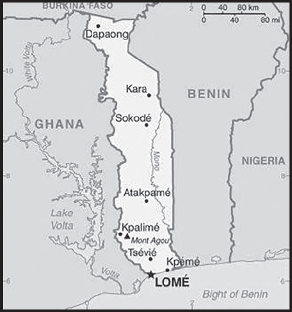
Location: Western Africa, bordering the Bight of Benin, between Benin and Ghana
Geographic coordinates: 8 00 N, 1 10 E
Map references: Africa
Area: total: 56,785 sq km
land: 54,385 sq km
water: 2,400 sq km
comparison ranking: total 126
Area - comparative: slightly smaller than West Virginia
Land boundaries: total: 1,880 km
border countries (3): Benin 651 km; Burkina Faso 131 km; Ghana 1,098 km
Coastline: 56 km
Maritime claims: territorial sea: 30 nm; note: the US does not recognize this claim
exclusive economic zone: 200 nm
Climate: tropical; hot, humid in south; semiarid in north
Terrain: gently rolling savanna in north; central hills; southern plateau; low coastal plain with extensive lagoons and marshes
Elevation: highest point: Mont Agou 986 m
lowest point: Atlantic Ocean 0 m
mean elevation: 236 m
Natural resources: phosphates, limestone, marble, arable land
Land use: agricultural land: 67.4% (2018 est.)
arable land: 45.2% (2018 est.)
permanent crops: 3.8% (2018 est.)
permanent pasture: 18.4% (2018 est.)
forest: 4.9% (2018 est.)
other: 27.7% (2018 est.)
Irrigated land: 70 sq km (2012)
Major watersheds (area sq km): Atlantic Ocean drainage: Volta (410,991 sq km)
Population distribution: one of the more densely populated African nations with most of the population residing in rural communities, density is highest in the south on or near the Atlantic coast as shown in this population distribution map
Natural hazards: hot, dry harmattan wind can reduce visibility in north during winter; periodic droughts
Geography - note: the country’s length allows it to stretch through six distinct geographic regions; climate varies from tropical to savanna
PEOPLE AND SOCIETY
Population: 8,703,961 (2023 est.)
comparison ranking: 101
Nationality: noun: Togolese (singular and plural)
adjective: Togolese
Ethnic groups: Adja-Ewe/Mina 42.4%, Kabye/Tem 25.9%, Para-Gourma/Akan 17.1%, Akposso/Akebu 4.1%, Ana-Ife 3.2%, other Togolese 1.7%, foreigners 5.2%, no response 0.4% (2013-14 est.)
note: Togo has an estimated 37 ethnic groups
Languages: French (official, the language of commerce), Ewe and Mina (the two major African languages in the south), Kabye (sometimes spelled Kabiye) and Dagomba (the two major African languages in the north)
Religions: Christian 42.3%, folk religion 36.9%, Muslim 14%, Hindu <1%, Buddhist <1%, Jewish <1%, other <1%, none 6.2% (2020 est.)
Demographic profile: Togo’s population is estimated to have grown to four times its size between 1960 and 2010. With nearly 60% of its populace under the age of 25 and a high annual growth rate attributed largely to high fertility, Togo’s population is likely to continue to expand for the foreseeable future. Reducing fertility, boosting job creation, and improving education will be essential to reducing the country’s high poverty rate. In 2008, Togo eliminated primary school enrollment fees, leading to higher enrollment but increased pressure on limited classroom space, teachers, and materials. Togo has a good chance of achieving universal primary education, but educational quality, the underrepresentation of girls, and the low rate of enrollment in secondary and tertiary schools remain concerns.
Togo is both a country of emigration and asylum. In the early 1990s, southern Togo suffered from the economic decline of the phosphate sector and ethnic and political repression at the hands of dictator Gnassingbe EYADEMA and his northern, Kabye-dominated administration. The turmoil led 300,000 to 350,000 predominantly southern Togolese to flee to Benin and Ghana, with most not returning home until relative stability was restored in 1997. In 2005, another outflow of 40,000 Togolese to Benin and Ghana occurred when violence broke out between the opposition and security forces over the disputed election of EYADEMA’s son Faure GNASSINGBE to the presidency. About half of the refugees reluctantly returned home in 2006, many still fearing for their safety. Despite ethnic tensions and periods of political unrest, Togo in December 2022 was home to almost 8,400 refugees from Ghana.
Age structure: 0-14 years: 38.98% (male 1,720,743/female 1,672,286)
15-64 years: 56.76% (male 2,413,709/female 2,526,816)
65 years and over: 4.26% (2023 est.) (male 153,461/female 216,946)
Dependency ratios: total dependency ratio: 76.5
youth dependency ratio: 71
elderly dependency ratio: 5.5
potential support ratio: 18.3 (2021 est.)
Median age: total: 20.5 years (2023 est.)
male: 19.8 years
female: 21.3 years
comparison ranking: total 196
Population growth rate: 2.45% (2023 est.)
comparison ranking: 23
Birth rate: 31.4 births/1,000 population (2023 est.)
comparison ranking: 24
Death rate: 5.2 deaths/1,000 population (2023 est.)
comparison ranking: 191
Net migration rate: -1.8 migrant(s)/1,000 population (2023 est.)
comparison ranking: 167
Population distribution: one of the more densely populated African nations with most of the population residing in rural communities, density is highest in the south on or near the Atlantic coast as shown in this population distribution map
Urbanization: urban population: 44.5% of total population (2023)
rate of urbanization: 3.6% annual rate of change (2020-25 est.)
Major urban areas - population: 1.982 million LOME (capital) (2023)
Sex ratio: at birth: 1.03 male(s)/female
0-14 years: 1.03 male(s)/female
15-64 years: 0.96 male(s)/female
65 years and over: 0.71 male(s)/female
total population: 0.97 male(s)/female (2023 est.)
Mother’s mean age at first birth: 25 years (2017 est.)
note: data represents median age at first birth among women 25-29
Maternal mortality ratio: 399 deaths/100,000 live births (2020 est.)
comparison ranking: 23
Infant mortality rate: total: 39.8 deaths/1,000 live births (2023 est.)
male: 44.4 deaths/1,000 live births
female: 35 deaths/1,000 live births
comparison ranking: total 30
Life expectancy at birth: total population: 71.7 years (2023 est.)
male: 69.1 years
female: 74.4 years
comparison ranking: total population 165
Total fertility rate: 4.18 children born/woman (2023 est.)
comparison ranking: 21
Gross reproduction rate: 2.06 (2023 est.)
Contraceptive prevalence rate: 23.9% (2017)
Drinking water source: improved: urban: 93.8% of population
rural: 60.3% of population
total: 74.6% of population
unimproved: urban: 6.2% of population
rural: 39.7% of population
total: 25.4% of population (2020 est.)
Current health expenditure: 6% of GDP (2020)
Physicians density: 0.08 physicians/1,000 population (2020)
Hospital bed density: 0.7 beds/1,000 population (2011)
Sanitation facility access: improved: urban: 81.9% of population
rural: 18.3% of population
total: 45.5% of population
unimproved: urban: 18.1% of population
rural: 81.7% of population
total: 54.5% of population (2020 est.)
Major infectious diseases: degree of risk: very high (2023)
food or waterborne diseases: bacterial and protozoal diarrhea, hepatitis A, and typhoid fever
vectorborne diseases: malaria and dengue fever
water contact diseases: schistosomiasis
animal contact diseases: rabies
respiratory diseases: meningococcal meningitis
note: on 31 August 2023, the US Centers for Disease Control and Prevention (CDC) issued a Travel Alert for polio in Africa; Togo is currently considered a high risk to travelers for circulating vaccine-derived polioviruses (cVDPV); vaccine-derived poliovirus (VDPV) is a strain of the weakened poliovirus that was initially included in oral polio vaccine (OPV) and that has changed over time and behaves more like the wild or naturally occurring virus; this means it can be spread more easily to people who are unvaccinated against polio and who come in contact with the stool or respiratory secretions, such as from a sneeze, of an “infected” person who received oral polio vaccine; the CDC recommends that before any international travel, anyone unvaccinated, incompletely vaccinated, or with an unknown polio vaccination status should complete the routine polio vaccine series; before travel to any high-risk destination, the CDC recommends that adults who previously completed the full, routine polio vaccine series receive a single, lifetime booster dose of polio vaccine
Obesity - adult prevalence rate: 8.4% (2016)
comparison ranking: 151
Alcohol consumption per capita: total: 1.4 liters of pure alcohol (2019 est.)
beer: 0.78 liters of pure alcohol (2019 est.)
wine: 0.09 liters of pure alcohol (2019 est.)
spirits: 0.2 liters of pure alcohol (2019 est.)
other alcohols: 0.33 liters of pure alcohol (2019 est.)
comparison ranking: total 141
Tobacco use: total: 6.8% (2020 est.)
male: 12.3% (2020 est.)
female: 1.2% (2020 est.)
comparison ranking: total 158
Children under the age of 5 years underweight: 15.2% (2017)
comparison ranking: 33
Currently married women (ages 15-49): 62% (2023 est.)
Child marriage: women married by age 15: 6.4%
women married by age 18: 24.8%
men married by age 18: 2.6% (2017 est.)
Education expenditures: 4% of GDP (2020 est.)
comparison ranking: 118
Literacy: definition: age 15 and over can read and write
total population: 66.5%
male: 80%
female: 55.1% (2019)
School life expectancy (primary to tertiary education): total: 13 years
male: 14 years
female: 12 years (2017)
Youth unemployment rate (ages 15-24): total: 9.7% (2021 est.)
male: 12.3%
female: 7.7%
comparison ranking: total 156
ENVIRONMENT
Environment - current issues: deforestation attributable to slash-and-burn agriculture and the use of wood for fuel; very little rain forest still present and what remains is highly degraded; desertification; water pollution presents health hazards and hinders the fishing industry; air pollution increasing in urban areas
Environment - international agreements: party to: Biodiversity, Climate Change, Climate Change-Kyoto Protocol, Climate Change-Paris Agreement, Comprehensive Nuclear Test Ban, Desertification, Endangered Species, Hazardous Wastes, Law of the Sea, Nuclear Test Ban, Ozone Layer Protection, Ship Pollution, Tropical Timber 2006, Wetlands, Whaling
signed, but not ratified: none of the selected agreements
Climate: tropical; hot, humid in south; semiarid in north
Land use: agricultural land: 67.4% (2018 est.)
arable land: 45.2% (2018 est.)
permanent crops: 3.8% (2018 est.)
permanent pasture: 18.4% (2018 est.)
forest: 4.9% (2018 est.)
other: 27.7% (2018 est.)
Urbanization: urban population: 44.5% of total population (2023)
rate of urbanization: 3.6% annual rate of change (2020-25 est.)
Revenue from forest resources: 3.96% of GDP (2018 est.)
comparison ranking: 18
Revenue from coal: 0% of GDP (2018 est.)
comparison ranking: 55
Air pollutants: particulate matter emissions: 35.66 micrograms per cubic meter (2019 est.)
carbon dioxide emissions: 3 megatons (2016 est.)
methane emissions: 3.06 megatons (2020 est.)
Waste and recycling: municipal solid waste generated annually: 1,109,030 tons (2014 est.)
municipal solid waste recycled annually: 22,181 tons (2012 est.)
percent of municipal solid waste recycled: 2% (2012 est.)
Major watersheds (area sq km): Atlantic Ocean drainage: Volta (410,991 sq km)
Total water withdrawal: municipal: 140 million cubic meters (2020 est.)
industrial: 10 million cubic meters (2020 est.)
agricultural: 80 million cubic meters (2020 est.)
Total renewable water resources: 14.7 billion cubic meters (2020 est.)
GOVERNMENT
Country name: conventional long form: Togolese Republic
conventional short form: Togo
local long form: Republique Togolaise
local short form: none
former: French Togoland
etymology: derived from the Ewe words “to” (river) and “godo” (on the other side) to give the sense of “on the other side of the river”; originally, this designation applied to the town of Togodo (now Togoville) on the northern shore of Lake Togo, but the name was eventually extended to the entire nation
Government type: presidential republic
Capital: name: Lome
geographic coordinates: 6 07 N, 1 13 E
time difference: UTC 0 (5 hours ahead of Washington, DC, during Standard Time)
etymology: Lome comes from “alotime” which in the native Ewe language means “among the alo plants”; alo trees dominated the city’s original founding site
Administrative divisions: 5 regions (regions, singular - region); Centrale, Kara, Maritime, Plateaux, Savanes
Independence: 27 April 1960 (from French-administered UN trusteeship)
National holiday: Independence Day, 27 April (1960)
Constitution: history: several previous; latest adopted 27 September 1992, effective 14 October 1992
amendments: proposed by the president of the republic or supported by at least one fifth of the National Assembly membership; passage requires four-fifths majority vote by the Assembly; a referendum is required if approved by only two-thirds majority of the Assembly or if requested by the president; constitutional articles on the republican and secular form of government cannot be amended; amended 2002, 2007, last in 2019 when the National Assembly unanimously approved a package of amendments, including setting presidential term limits of two 5-year mandates
Legal system: customary law system
International law organization participation: accepts compulsory ICJ jurisdiction with reservations; non-party state to the ICCt
Citizenship: citizenship by birth: no
citizenship by descent only: at least one parent must be a citizen of Togo
dual citizenship recognized: yes
residency requirement for naturalization: 5 years
Suffrage: 18 years of age; universal
Executive branch: chief of state: President Faure GNASSINGBE (since 4 May 2005)
head of government: Prime Minister Victoire Tomegah DOGBE (since 28 September 2020)
cabinet: Council of Ministers appointed by the president on the advice of the prime minister
elections/appointments: president directly elected by simple majority popular vote for a 5-year term (no term limits); election last held on 22 February 2020 (next to be held in 2025); prime minister appointed by the president
election results: 2020: Faure GNASSINGBE reelected president; percent of vote - Faure GNASSINGBE (UNIR) 70.8%, Agbeyome KODJO (MPDD) 19.5%, Jean-Pierre FABRE (ANC) 4.7%, other 5%
2015: Faure GNASSINGBE reelected president; percent of vote - Faure GNASSINGBE (UNIR) 58.8%, Jean-Pierre FABRE (ANC) 35.2%, Tchaboure GOGUE (ADDI) 4%, other 2%
Legislative branch: description: unicameral National Assembly or Assemblee Nationale (91 seats; members directly elected in multi-seat constituencies by closed, party-list proportional representation vote to serve 5-year terms); party lists are required to contain equal numbers of men and women
elections: last held on 20 December 2018 (next to be held on 31 December 2023)
election results: percent of vote by coalition/party - NA; seats by party - UNIR 59, UFC 7, NET 3, MPDD 2, MRC 1, PDP 1, independent 18; composition - men 76, women 15, percent of women 16.5%
Judicial branch: highest court(s): Supreme Court or Cour Supreme (organized into criminal and administrative chambers, each with a chamber president and advisors); Constitutional Court (consists of 9 judges, including the court president)
judge selection and term of office: Supreme Court president appointed by decree of the president of the republic upon the proposal of the Supreme Council of the Magistracy, a 9-member judicial, advisory, and disciplinary body; other judicial appointments and judge tenure NA; Constitutional Court judges appointed by the National Assembly; judge tenure NA
subordinate courts: Court of Assizes (sessions court); Appeal Court; tribunals of first instance (divided into civil, commercial, and correctional chambers; Court of State Security; military tribunal
Political parties and leaders: Action Committee for Renewal or CAR [Dodji APEVON]
Alliance of Democrats for Integral Development or ADDI [Tchaboure GOGUE]
Democratic Convention of African Peoples or CDPA [Léopold GNININVI]
Democratic Forces for the Republic or FDR [Dodji APEVON]
National Alliance for Change or ANC [Jean-Pierre FABRE]
New Togolese Commitment [Gerry TAAMA]
Pan-African National Party or PNP [Tikpi ATCHADAM]
Pan-African Patriotic Convergence or CPP (vacant)
Patriotic Movement for Democracy and Development or MPDD [Agbeyome KODJO]
Socialist Pact for Renewal or PSR [Abi TCHESSA]
The Togolese Party [Nathaniel OLYMPIO]
Union of Forces for Change or UFC [Jean-Pierre FABRE]
Union for the Republic or UNIR [Faure GNASSINGBE]
International organization participation: ACP, AfDB, AU, ECOWAS, EITI (compliant country), Entente, FAO, FZ, G-77, IAEA, IBRD, ICAO, ICRM, IDA, IDB, IFAD, IFC, IFRCS, ILO, IMF, IMO, Interpol, IOC, IOM, IPU, ISO (correspondent), ITSO, ITU, ITUC (NGOs), MIGA, MINURSO, MINUSMA, NAM, OIC, OIF, OPCW, PCA, UN, UNAMID, UNCTAD, UNESCO, UNHCR, UNIDO, UNMIL, UNOCI, UNWTO, UPU, WADB (regional), WAEMU, WCO, WFTU (NGOs), WHO, WIPO, WMO, WTO
Diplomatic representation in the US: chief of mission: Ambassador Frederic Edem HEGBE (since 24 April 2017)
chancery: 2208 Massachusetts Avenue NW, Washington, DC 20008
telephone: [1] (202) 234-4212
FAX: [1] (202) 232-3190
email address and website: embassyoftogo@hotmail.com
Diplomatic representation from the US: chief of mission: Ambassador Elizabeth FITZSIMMONS (since 26 April 2022)
embassy: Boulevard Eyadema, B.P. 852, Lome
mailing address: 2300 Lome Place, Washington, DC 20521-2300
telephone: [228] 2261-5470
FAX: [228] 2261-5501
email address and website: consularLome@state.gov
Flag description: five equal horizontal bands of green (top and bottom) alternating with yellow; a white five-pointed star on a red square is in the upper hoist-side corner; the five horizontal stripes stand for the five different regions of the country; the red square is meant to express the loyalty and patriotism of the people, green symbolizes hope, fertility, and agriculture, while yellow represents mineral wealth and faith that hard work and strength will bring prosperity; the star symbolizes life, purity, peace, dignity, and Togo’s independence
note: uses the popular Pan-African colors of Ethiopia
National symbol(s): lion; national colors: green, yellow, red, white
National anthem: name: “Salut a toi, pays de nos aieux” (Hail to Thee, Land of Our Forefathers)
lyrics/music: Alex CASIMIR-DOSSEH
note: adopted 1960, restored 1992; this anthem was replaced by another during one-party rule between 1979 and 1992
National heritage: total World Heritage Sites: 1 (cultural)
selected World Heritage Site locales: Koutammakou; the Land of the Batammariba
ECONOMY
Economic overview: low-income West African economy; primarily agrarian economy; has a deep-water port; growing international shipping locale; improving privatization and public budgeting transparency; key phosphate mining industry; extremely high rural poverty
Real GDP (purchasing power parity): $18.369 billion (2021 est.)
$17.451 billion (2020 est.)
$17.15 billion (2019 est.)
note: data are in 2017 dollars
comparison ranking: 156
Real GDP growth rate: 5.26% (2021 est.)
1.75% (2020 est.)
5.46% (2019 est.)
comparison ranking: 87
Real GDP per capita: $2,100 (2021 est.)
$2,100 (2020 est.)
$2,100 (2019 est.)
note: data are in 2017 dollars
comparison ranking: 211
GDP (official exchange rate): $5.232 billion (2018 est.)
Inflation rate (consumer prices): 1.83% (2020 est.)
0.69% (2019 est.)
0.93% (2018 est.)
comparison ranking: 164
Credit ratings:
Moody’s rating: B3 (2019)
Standard & Poors rating: B (2019)
note: The year refers to the year in which the current credit rating was first obtained.
GDP - composition, by sector of origin: agriculture: 28.8% (2017 est.)
industry: 21.8% (2017 est.)
services: 49.8% (2017 est.)
comparison rankings: services 178; industry 133; agriculture 18
GDP - composition, by end use: household consumption: 84.5% (2017 est.)
government consumption: 11.4% (2017 est.)
investment in fixed capital: 23.4% (2017 est.)
investment in inventories: -1.4% (2017 est.)
exports of goods and services: 43.1% (2017 est.)
imports of goods and services: -61% (2017 est.)
Agricultural products: cassava, maize, yams, sorghum, beans, oil palm fruit, rice, vegetables, cotton, groundnuts
Industries: phosphate mining, agricultural processing, cement, handicrafts, textiles, beverages
Industrial production growth rate: 5.32% (2020 est.)
comparison ranking: 84
Labor force: 2.965 million (2021 est.)
comparison ranking: 108
Labor force - by occupation: agriculture: 65%
industry: 5%
services: 30% (1998 est.)
Unemployment rate: 4% (2021 est.)
3.94% (2020 est.)
3.72% (2019 est.)
comparison ranking: 175
Youth unemployment rate (ages 15-24): total: 9.7% (2021 est.)
male: 12.3%
female: 7.7%
comparison ranking: total 156
Population below poverty line: 55.1% (2015 est.)
Gini Index coefficient - distribution of family income: 42.4 (2018 est.)
comparison ranking: 39
Household income or consumption by percentage share: lowest 10%: 3.3%
highest 10%: 27.1% (2006)
Budget: revenues: $1.275 billion (2019 est.)
expenditures: $1.158 billion (2019 est.)
Budget surplus (+) or deficit (-): -3.8% (of GDP) (2017 est.)
comparison ranking: 153
Public debt: 75.7% of GDP (2017 est.)
81.6% of GDP (2016 est.)
comparison ranking: 46
Taxes and other revenues: 13.16% (of GDP) (2019 est.)
comparison ranking: 168
Fiscal year: calendar year
Current account balance: -$20.738 million (2020 est.)
-$55.444 million (2019 est.)
-$184.852 million (2018 est.)
comparison ranking: 84
Exports: $1.722 billion (2020 est.) note: data are in current year dollars
$1.665 billion (2019 est.) note: data are in current year dollars
$1.703 billion (2018 est.)
comparison ranking: 165
Exports - partners: India 16%, Benin 15%, Burkina Faso 6%, France 6%, Morocco 5% (2019)
Exports - commodities: refined petroleum, crude petroleum, electricity, calcium phosphates, cotton (2019)
Imports: $2.389 billion (2020 est.) note: data are in current year dollars
$2.261 billion (2019 est.) note: data are in current year dollars
$2.329 billion (2018 est.)
comparison ranking: 165
Imports - partners: China 18%, South Korea 13%, India 11%, Belgium 10%, Netherlands 8%, United States 5% (2019)
Imports - commodities: refined petroleum, motorcycles, crude petroleum, rice, broadcasting equipment (2019)
Reserves of foreign exchange and gold: $77.8 million (31 December 2017 est.)
$42.6 million (31 December 2016 est.)
comparison ranking: 188
Debt - external: $1.442 billion (31 December 2017 est.)
$1.22 billion (31 December 2016 est.)
comparison ranking: 161
Exchange rates: Communaute Financiere Africaine francs (XOF) per US dollar -
Exchange rates: 554.531 (2021 est.)
575.586 (2020 est.)
585.911 (2019 est.)
555.446 (2018 est.)
580.657 (2017 est.)
ENERGY
Electricity access: population without electricity: (2020) 5 million
electrification - total population: 55.7% (2021)
electrification - urban areas: 96.3% (2021)
electrification - rural areas: 24.6% (2021)
Electricity: installed generating capacity: 210,000 kW (2020 est.)
consumption: 1,180,140,000 kWh (2019 est.)
exports: 118 million kWh (2019 est.)
imports: 963 million kWh (2019 est.)
transmission/distribution losses: 210 million kWh (2019 est.)
comparison rankings: installed generating capacity 169; transmission/distribution losses 147; imports 73; exports 90; consumption 155
Electricity generation sources: fossil fuels: 82.2% of total installed capacity (2020 est.)
solar: 0.6% of total installed capacity (2020 est.)
hydroelectricity: 17.2% of total installed capacity (2020 est.)
Coal: production: 0 metric tons (2020 est.)
consumption: 46,000 metric tons (2020 est.)
exports: 0 metric tons (2020 est.)
imports: 46,000 metric tons (2020 est.)
proven reserves: 0 metric tons (2019 est.)
Petroleum: total petroleum production: 0 bbl/day (2021 est.)
refined petroleum consumption: 10,000 bbl/day (2019 est.)
Refined petroleum products - imports: 13,100 bbl/day (2015 est.)
comparison ranking: 142
Natural gas: production: 0 cubic meters (2021 est.)
consumption: 0 cubic meters (2020 est.)
exports: 0 cubic meters (2021 est.)
imports: 44.797 million cubic meters (2019 est.)
proven reserves: 0 cubic meters (2021 est.)
Carbon dioxide emissions: 2.244 million metric tonnes of CO2 (2019 est.)
from coal and metallurgical coke: 706,000 metric tonnes of CO2 (2019 est.)
from petroleum and other liquids: 1.451 million metric tonnes of CO2 (2019 est.)
from consumed natural gas: 87,000 metric tonnes of CO2 (2019 est.)
comparison ranking: total emissions 158
Energy consumption per capita: 4.113 million Btu/person (2019 est.)
comparison ranking: 174
COMMUNICATIONS
Telephones - fixed lines: total subscriptions: 54,000 (2021 est.)
subscriptions per 100 inhabitants: (2021 est.) less than 1
comparison ranking: total subscriptions 153
Telephones - mobile cellular: total subscriptions: 6.3 million (2021 est.)
subscriptions per 100 inhabitants: 72 (2021 est.)
comparison ranking: total subscriptions 114
Telecommunication systems: general assessment: include radio, television, fixed and mobile telephones, and the Internet (2022)
domestic: fixed-line less than 1 per 100 and mobile-cellular is 72 telephones per 100 persons (2021)
international: country code - 228; landing point for the WACS submarine cable, linking countries along the west coast of Africa with each other and with Portugal; satellite earth stations - 1 Intelsat (Atlantic Ocean), 1 Symphonie (2020)
Broadcast media: 1 state-owned TV station with multiple transmission sites; five private TV stations broadcast locally; cable TV service is available; state-owned radio network with two stations (in Lome and Kara); several dozen private radio stations and a few community radio stations; transmissions of multiple international broadcasters available (2019)
Internet country code: .tg
Internet users: total: 3.01 million (2021 est.)
percent of population: 35% (2021 est.)
comparison ranking: total 120
Broadband - fixed subscriptions: total: 52,706 (2020 est.)
subscriptions per 100 inhabitants: 0.6 (2020 est.)
comparison ranking: total 143
TRANSPORTATION
National air transport system: number of registered air carriers: 1 (2020)
inventory of registered aircraft operated by air carriers: 8
annual passenger traffic on registered air carriers: 566,295 (2018)
annual freight traffic on registered air carriers: 10.89 million (2018) mt-km
Civil aircraft registration country code prefix: 5V
Airports: 8 (2021)
comparison ranking: total 164
Airports - with paved runways: 2
note: paved runways have a concrete or asphalt surface but not all have facilities for refueling, maintenance, or air traffic control; the length of a runway required for aircraft to safely operate depends on a number of factors including the type of aircraft, the takeoff weight (including passengers, cargo, and fuel), engine types, flap settings, landing speed, elevation of the airport, and average maximum daily air temperature; paved runways can reach a length of 5,000 m (16,000 ft.), but the “typical” length of a commercial airline runway is between 2,500-4,000 m (8,000-13,000 ft.)
Airports - with unpaved runways: 6
note: unpaved runways have a surface composition such as grass or packed earth and are most suited to the operation of light aircraft; unpaved runways are usually short, often less than 1,000 m (3,280 ft.) in length; airports with unpaved runways often lack facilities for refueling, maintenance, or air traffic control
Pipelines: 62 km gas
Railways: total: 568 km (2014)
narrow gauge: 568 km (2014) 1.000-m gauge
comparison ranking: total 110
Roadways: total: 9,951 km (2018)
paved: 1,794 km (2018)
unpaved: 8,157 km (2018)
urban: 1,783 km (2018)
comparison ranking: total 135
Waterways: 50 km (2011) (seasonally navigable by small craft on the Mono River depending on rainfall)
comparison ranking: 113
Merchant marine: total: 403 (2022)
by type: bulk carrier 1, container ship 10, general cargo 254, oil tanker 57, other 81
comparison ranking: total 48
Ports and terminals: major seaport(s): Kpeme, Lome
container port(s) (TEUs): Lome (1,962,304) (2021)
MILITARY AND SECURITY
Military and security forces: Togolese Armed Forces (Forces Armees Togolaise, FAT): Togolese Army (l’Armee de Terre), Togolese Navy (Forces Naval Togolaises), Togolese Air Force (Armee de l’Air), National Gendarmerie (Gendarmerie Nationale Togolaise or GNT)
Ministry of Security and Civil Protection: National Police Directorate (Direction de la Police Nationale) (2023)
note: the Police Directorate and GNT are responsible for law enforcement and maintenance of order within the country; the GNT is also responsible for migration and border enforcement; the GNT falls under the Ministry of the Armed Forces but also reports to the Ministry of Security and Civil Protection on many matters involving law enforcement and internal security; in 2022, the Ministry of the Armed Forces was made part of the Office of the Presidency
Military expenditures: 2.1% of GDP (2022 est.)
1.9% of GDP (2021 est.)
2% of GDP (2020 est.)
2.6% of GDP (2019 est.)
1.9% of GDP (2018 est.)
comparison ranking: 55
Military and security service personnel strengths: estimated 15,000 active-duty personnel, including approximately 3,000 Gendarmerie (2023)
note: in January 2022, the Togolese Government announced its intent to boost the size of the FAT to more than 20,000 by 2025
Military equipment inventories and acquisitions: the FAT has a small, mixed inventory of mostly older equipment from a variety of countries; in recent years, it has received limited amounts of equipment from several suppliers, including France, Russia, and the US (2023)
Military service age and obligation: 18 years of age for military service for men and women; 24-month service obligation; no conscription (2023)
note: as of 2022, about 7% of the military’s personnel were women
Military deployments: 725 (plus about 300 police) Mali (MINUSMA) (2023)
Military - note: since its creation in 1963, the Togolese military has had a history of interfering in the country’s politics with assassinations, coups, influence, and a large military crackdown in 2005 that killed hundreds; over the past decade, however, it has made some efforts to reform and professionalize, as well as increase its role in UN peacekeeping activities; Togo maintains a regional peacekeeping training center for military and police in Lome; the military participates in multinational exercises and has received training from foreign partners, including France and the US the FAT’s current focuses are primarily terrorism and maritime security; in recent years, it has increased operations in the northern border region of the country to boost border security and prevent terrorist infiltrations from Jama’at Nasr al-Islam wal Muslimin (JNIM), a coalition of al-Qa’ida-affiliated militant groups based in Mali that also operates in neighboring Burkina Faso; in 2022, the Togolese Government declared a state of emergency in the north due to the threat from JNIM following an attack on a Togolese military post that killed several soldiers; the Navy and Air Force have increased focus on combating piracy and smuggling in the Gulf of Guinea the Army has a mixed force of small, lightly-armed combined arms, infantry, and commando regiments, as well as a rapid reaction force; the Gendarmerie includes mobile, regionally-based, and maritime units; the Navy operates a few patrol boats while the Air Force has a small inventory of training, light attack-capable, and transport aircraft, as well as combat helicopters and a few armed UAVs acquired from Turkey in 2022 (2023)
TERRORISM
Terrorist group(s): Terrorist group(s): Jama’at Nusrat al Islam wal Muslimeen (JNIM)
note: details about the history, aims, leadership, organization, areas of operation, tactics, targets, weapons, size, and sources of support of the group(s) appear(s) in Appendix-T
TRANSNATIONAL ISSUES
Disputes - international: Togo-Benin: in 2001, Benin claimed Togo moved boundary monuments - joint commission continues to resurvey the boundary; Benin’s and Togo’s Adjrala hydroelectric dam project on the Mona River, proposed in the 1990s, commenced in 2017 with funding from a Chinese bank
Togo-Burkina Faso: none identified
Togo-Ghana: none identified
Refugees and internally displaced persons: refugees (country of origin): 9,846 (Burkina Faso), 8,436 (Ghana) (2023)
Illicit drugs: transit hub for Nigerian heroin and cocaine traffickers; money laundering not a significant problem
TOKELAU
INTRODUCTION
Background: Tokelau, which comprises three atolls, was first settled by Polynesians around A.D. 1000. The three atolls operated relatively independently but had contact with one another, intermarrying and occasionally fighting wars. Fakaofo Atoll eventually subjugated the other two. British explorer John BYRON was the first European to see Atafu Atoll in 1765. British naval officer Edward EDWARDS saw Nukunonu Atoll in 1791, and ships occasionally continued to pass by Atafu and Nukunonu. In 1835, a US whaling ship became the first non-Pacific island ship to pass by Fakaofo. Catholic and Protestant missionaries arrived in 1845 and converted the population on the islands on which they landed. To this day, Nukunonu is predominantly Catholic while Atafu is mostly Protestant; Catholic and Protestant missionaries both worked in Fakaofo, and the population there is more mixed.
In 1863, Peruvian slave traders, masquerading as missionaries, kidnapped nearly all the men from Tokelau, and local governance moved to a system based on a Council of Elders, which still exists today. The atolls were repopulated when new Polynesian settlers and American and European migrants intermarried with local Tokelauan women. Tokelau became a British protectorate in 1889 and included in the Gilbert and Ellice Islands Protectorate - later a colony - in 1908. In 1925, the UK placed Tokelau under New Zealand administration. The Tokelau Islands Act of 1948 formally transferred sovereignty from the UK to New Zealand and Tokelauans were granted New Zealand citizenship. In 1979, the US relinquished its claims over Tokelau in the Treaty of Tokehega, and Tokelau relinquished its claims over Swains Island, which is part of American Samoa.
Economic opportunities in Tokelau are sparse, and about 80% of Tokelauans live in New Zealand. Tokelau held two self-governance referendums in 2006 and 2007, in which more than 60% of voters chose to go into free association with New Zealand; however, the referendums failed to achieve the two-thirds majority necessary to enact a status change. Tokelau lacks an airport and is only accessible via a day-long boat trip from Samoa, although a site for an airstrip on Nukunonu was selected in 2019. Because of its dependency on Samoa for transportation, in 2011, Tokelau followed Samoa’s lead and shifted the international date line to its east, skipping December 30 and becoming one hour ahead of New Zealand rather than 23 hours behind.
GEOGRAPHY
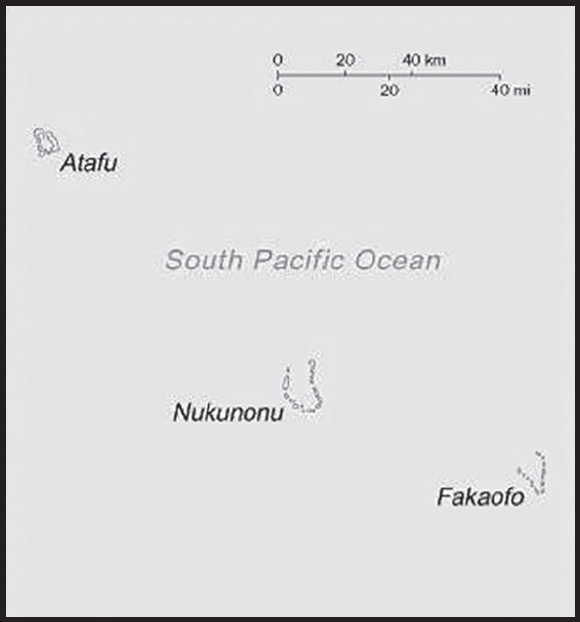
Location: Oceania, group of three atolls in the South Pacific Ocean, about one-half of the way from Hawaii to New Zealand
Geographic coordinates: 9 00 S, 172 00 W
Map references: Oceania
Area: total: 12 sq km
land: 12 sq km
water: 0 sq km
comparison ranking: total 241
Area - comparative: about 17 times the size of the National Mall in Washington, DC
Land boundaries: total: 0 km
Coastline: 101 km
Maritime claims: territorial sea: 12 nm
exclusive economic zone: 200 nm
Climate: tropical; moderated by trade winds (April to November)
Terrain: low-lying coral atolls enclosing large lagoons
Elevation: highest point: unnamed location 5 m
lowest point: Pacific Ocean 0 m
Natural resources: Fisheries
Land use: agricultural land: 60% (2018 est.)
arable land: 0% (2018 est.)
permanent crops: 60% (2018 est.)
permanent pasture: 0% (2018 est.)
forest: 0% (2018 est.)
other: 40% (2018 est.)
Irrigated land: 0 sq km (2022)
Population distribution: the country’s small population is fairly evenly distributed amongst the three atolls
Natural hazards: lies in Pacific cyclone belt
Geography - note: consists of three atolls (Atafu, Fakaofo, Nukunonu), each with a lagoon surrounded by a number of reef-bound islets of varying length and rising to over 3 m above sea level
PEOPLE AND SOCIETY
Population: 1,647 (2019 est.)
comparison ranking: 233
Nationality: noun: Tokelauan(s)
adjective: Tokelauan
Ethnic groups: Tokelauan 64.5%, part Tokelauan/Samoan 9.7%, part Tokelauan/Tuvaluan 2.8%, Tuvaluan 7.5%, Samoan 5.8%, other Pacific Islander 3.4%, other 5.6%, unspecified 0.8% (2016 est.)
Languages: Tokelauan 88.1% (a Polynesian language), English 48.6%, Samoan 26.7%, Tuvaluan 11.2%, Kiribati 1.5%, other 2.8%, none 2.8%, unspecified 0.8% (2016 ests.)
note: shares sum to more than 100% because some respondents gave more than one answer on the census
Religions: Congregational Christian Church 50.4%, Roman Catholic 38.7%, Presbyterian 5.9%, other Christian 4.2%, unspecified 0.8% (2016 est.)
Dependency ratios: total dependency ratio: 60.4
youth dependency ratio: 47
elderly dependency ratio: 13.4
potential support ratio: 7.5 (2021)
Population growth rate: -0.01% (2019 est.)
comparison ranking: 197
Death rate: (2021 est.)
Net migration rate: -3.84 migrant(s)/1,000 population (2021 est.)
comparison ranking: 192
Population distribution: the country’s small population is fairly evenly distributed amongst the three atolls
Urbanization: urban population: 0% of total population (2023)
rate of urbanization: 0% annual rate of change (2020-25 est.)
Drinking water source: improved: urban: 0% of population
rural: 99.7% of population
total: 99.7% of population
unimproved: urban: 0% of population
rural: 0.3% of population
total: 0.3% of population (2020 est.)
Sanitation facility access: improved: total: 100% of population
unimproved: total: 0% of population (2020 est.)
Currently married women (ages 15-49): 52% (2023 est.)
Child marriage: women married by age 15: 0.4%
women married by age 18: 10.1%
men married by age 18: 2.8% (2019 est.)
ENVIRONMENT
Environment - current issues: overexploitation of certain fish and other marine species, coastal sand, and forest resources; pollution of freshwater lenses and coastal waters from improper disposal of chemicals
Climate: tropical; moderated by trade winds (April to November)
Land use: agricultural land: 60% (2018 est.)
arable land: 0% (2018 est.)
permanent crops: 60% (2018 est.)
permanent pasture: 0% (2018 est.)
forest: 0% (2018 est.)
other: 40% (2018 est.)
Urbanization: urban population: 0% of total population (2023)
rate of urbanization: 0% annual rate of change (2020-25 est.)
Total renewable water resources: 0 cubic meters (2017 est.)
GOVERNMENT
Country name: conventional long form: none
conventional short form: Tokelau
former: Union Islands, Tokelau Islands
etymology: “tokelau” is a Polynesian word meaning “north wind”
Government type: parliamentary democracy under a constitutional monarchy
Dependency status: self-administering territory of New Zealand; note - Tokelau and New Zealand have agreed to a draft constitution as Tokelau moves toward free association with New Zealand; a UN-sponsored referendum on self governance in October 2007 did not meet the two-thirds majority vote necessary for changing the political status
Capital: time difference: UTC+13 (18 hours ahead of Washington, DC during Standard Time)
note: there is no designated, official capital for Tokelau; the location of the capital rotates among the three atolls along with the head of government or Ulu o Tokelau
Administrative divisions: none (territory of New Zealand)
Independence: none (territory of New Zealand)
National holiday: Waitangi Day (Treaty of Waitangi established British sovereignty over New Zealand), 6 February (1840)
Constitution: history: many previous; latest effective 1 January 1949 (Tokelau Islands Act 1948)
amendments: proposed as a resolution by the General Fono; passage requires support by each village and approval by the General Fono; amended several times, last in 2007
Legal system: common law system of New Zealand
Citizenship: see New Zealand
Suffrage: 21 years of age; universal
Executive branch: chief of state: King CHARLES III (since 8 September 2022); represented by Governor-General of New Zealand Dame Cindy KIRO (since 21 September 2021); New Zealand is represented by Administrator Ross ARDERN (since May 2018)
head of government: (Ulu o Tokelau) Kelihiano KALOLO (since 8 March 2021); note - position rotates annually among the three Faipule (village leaders) of the atolls
cabinet: Council for the Ongoing Government of Tokelau (or Tokelau Council) functions as a cabinet; consists of 3 village leaders (Faipule) and 3 village mayors (Pulenuku)
elections/appointments: the monarchy is hereditary; governor general appointed by the monarch; administrator appointed by the Minister of Foreign Affairs and Trade in New Zealand; head of government chosen from the Council of Faipule to serve a 1-year term
note: the meeting place of the Tokelau Council rotates annually among the three atolls; this tradition has given rise to the somewhat misleading description that the capital rotates yearly between the three atolls; in actuality, it is the seat of the government councilors that rotates since Tokelau has no capital
Legislative branch: description: unicameral General Fono (20 seats apportioned by island - Atafu 7, Fakaofo 7, Nukunonu 6; members directly elected by simple majority vote to serve 3-year terms); note - the Tokelau Amendment Act of 1996 confers limited legislative power to the General Fono
elections: last held on 26 January 2023 depending on island (next to be held in January 2026)
election results: percent of vote by party - NA; seats by party - independent 20; composition - men 17, women 3, percent of women 15%
Judicial branch: highest court(s): Court of Appeal (in New Zealand) (consists of the court president and 8 judges sitting in 3- or 5-judge panels, depending on the case)
judge selection and term of office: judges nominated by the Judicial Selection Committee and approved by three-quarters majority of the Parliament; judges serve for life
subordinate courts: High Court (in New Zealand); Council of Elders or Taupulega
Political parties and leaders: none
International organization participation: PIF (associate member), SPC, UNESCO (associate), UPU
Diplomatic representation in the US: none (territory of New Zealand)
Diplomatic representation from the US: none (territory of New Zealand)
Flag description: a yellow stylized Tokelauan canoe on a dark blue field sails toward the manu - the Southern Cross constellation of four, white, five-pointed stars at the hoist side; the Southern Cross represents the role of Christianity in Tokelauan culture and, in conjunction with the canoe, symbolizes the country navigating into the future; the color yellow indicates happiness and peace, and the blue field represents the ocean on which the community relies
National symbol(s): tuluma (fishing tackle box); national colors: blue, yellow, white
National anthem: name: “Te Atua” (For the Almighty)
lyrics/music: unknown/Falani KALOLO
note: adopted 2008; in preparation for eventual self governance, Tokelau held a national contest to choose an anthem; as a territory of New Zealand, in addition to “God Defend New Zealand,” “God Save the King” serves as a royal anthem (see United Kingdom); “God Save the King” normally played only when a member of the royal family or the governorgeneral is present; in all other cases, “God Defend New Zealand” is played (see New Zealand)
ECONOMY
Economic overview: small New Zealand territorial island economy; labor force can work in New Zealand or Australia; significant remittances; largely solar-powered infrastructure; reliant on New Zealand funding; stamp, coin, and crafts producer
Real GDP (purchasing power parity): $7,711,583 (2017 est.)
note: data are in 2017 dollars.
comparison ranking: 229
Real GDP per capita: $6,004 (2017 est.)
$4,855 (2016 est.)
$4,292 (2015 est.)
note: data are in 2017 dollars
comparison ranking: 163
GDP (official exchange rate): $12.658 million (2017 est.)
note: data uses New Zealand Dollar (NZD) as the currency of exchange.
Inflation rate (consumer prices): 4% (2020 est.)
2.5% (2019 est.)
11% (2017 est.)
note: Tokelau notes that its wide inflation swings are due almost entirely due to cigarette prices, a chief import.
comparison ranking: 92
Agricultural products: coconuts, roots/tubers, tropical fruit, pork, bananas, eggs, poultry, pig offals, pig fat, fruit
Industries: small-scale enterprises for copra production, woodworking, plaited craft goods; stamps, coins; fishing
Labor force: 1,100 (2019 est.)
comparison ranking: 229
Unemployment rate: 2% (2015 est.)
note: Underemployment may be as high as 6.6%
comparison ranking: 212
Population below poverty line: NA
Budget: revenues: $24,324,473 (2017 est.)
expenditures: $11,666,542 (2017 est.)
Fiscal year: 1 April - 31 March
Exports: $103,000 (2015 est.)
$102,826 (2002 est.)
comparison ranking: 224
Exports - partners: Singapore 25%, France 19%, South Africa 7%, New Zealand 5%, United States 5%, Ireland 5% (2019)
Exports - commodities: oscilloscopes, house linens, fruits, nuts, recreational boats, iron products (2019)
Imports: $15,792,720 (2015 est.)
comparison ranking: 223
Imports - partners: Samoa 35%, Ireland 17%, Philippines 14%, Malaysia 13%, South Africa 9% (2019)
Imports - commodities: oscilloscopes, integrated circuits, refined petroleum, packaged medicines, orthopedic appliances (2019)
Exchange rates: New Zealand dollars (NZD) per US dollar -
Exchange rates: 1.543 (2017 est.)
COMMUNICATIONS
Telephones - fixed lines: total subscriptions: 300 (2010 est.)
subscriptions per 100 inhabitants: 22 (2010 est.)
comparison ranking: total subscriptions 220
Telecommunication systems: general assessment: a new submarine cable between New Zealand and Tokelau will provide high speed, reliable internet to Tokelau for the first time; due for completion in 2022, this will provide Tokelau with affordable, high quality internet and telecommunications, and better, more effective access to digital services and platforms (2021)
domestic: fixed-line teledensity is 0 per 100 persons (2019)
international: country code - 690; landing point for the Southern Cross NEXT submarine cable linking Australia, Tokelau, Samoa, Kiribati, Fiji, New Zealand and Los Angeles, CA (USA); radiotelephone service to Samoa; government-regulated telephone service (TeleTok); satellite earth stations - 3 (2020)
Broadcast media: Sky TV access for around 30% of the population; each atoll operates a radio service that provides shipping news and weather reports (2019)
Internet country code: .tk
Internet users: total: 800 (2021 est.)
percent of population: 58.3% (2021 est.)
comparison ranking: total 231
TRANSPORTATION
Roadways: total: 10 km (2019)
comparison ranking: total 222
Ports and terminals: none; offshore anchorage only
MILITARY AND SECURITY
Military - note: defense is the responsibility of New Zealand
TRANSNATIONAL ISSUES
Disputes - international: Tokelau-American Samoa (US): Tokelau included American Samoa’s Swains Island (Olosega) in its 2006 draft independence constitution; Swains Island has been administered by American Samoa since 1925; the 1980 Treaty of Tokehega delineates the maritime boundary between American Samoa and Tokelau; while not specifically mentioning Swains Island, the treaty notes in its preamble that New Zealand does not claim as part of Tokelau any island administered as part of American Samoa
TONGA
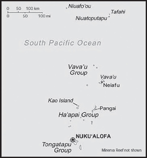
INTRODUCTION
Background: The first humans arrived in Tonga around 1000 B.C. The islands’ politics were probably highly centralized under the Tu’i Tonga, or Tongan king, by A.D. 950, and by 1200, the Tu’i Tonga had expanded his influence throughout Polynesia and into Melanesia and Micronesia. The Tongan Empire began to decline in the 1300s, descending into civil wars, a military defeat to Samoa, and internal political strife that saw successive leaders assassinated. By the mid-1500s, some Tu’i Tongans were ethnic Samoan and day-to-day administration of Tonga was transferred to a new position occupied by ethnic Tongans.
Dutch sailors explored the islands in the 1600s and British Captain James COOK visited Tonga three times in the 1770s, naming them the Friendly Islands for the positive reception he thought he received, even though the Tongans he encountered were plotting ways to kill him. In 1799, Tonga fell into a new round of civil wars over succession. Wesleyan missionaries arrived in 1822, quickly converting the population. In the 1830s, a low-ranking chief from Ha’apai began to consolidate control over the islands and won the support of the missionaries by declaring that he would dedicate Tonga to God. The chief soon made alliances with leaders on most of the other islands and was crowned King George TUPOU I in 1845, establishing the only still-extant Polynesian monarchy. TUPOU I declared Tonga a constitutional monarchy in 1875 and his successor, King George TUPOU II, agreed to enter a protectorate agreement with the UK in 1900 after rival Tongan chiefs tried to overthrow him. As a protectorate, Tonga never completely lost its indigenous governance, but it did become more isolated and the social hierarchy became more stratified between a group of nobles and a large class of commoners. Today, about one third of parliamentary seats are reserved for nobles.
Queen Salote TUPOU III negotiated the end of the protectorate in 1965, which was achieved under King TUPOU IV, who in 1970 withdrew from the protectorate and joined the Commonwealth of Nations. A prodemocracy movement gained steam in the early 2000s, led by future Prime Minister ‘Akilisi POHIVA, and in 2006, riots broke out in Nuku’alofa to protest the lack of progress on prodemocracy legislation. To appease the activists, in 2008, King George TUPOU V announced he was relinquishing most of his powers leading up to parliamentary elections in 2010; he died in 2012 and was succeeded by his brother ‘Aho’eitu TUPOU VI. Tropical Cyclone Gita, the strongest-ever recorded storm to impact Tonga, hit the islands in February 2018 causing extensive damage.
GEOGRAPHY
Location: Oceania, archipelago in the South Pacific Ocean, about two-thirds of the way from Hawaii to New Zealand
Geographic coordinates: 20 00 S, 175 00 W
Map references: Oceania
Area: total: 747 sq km
land: 717 sq km
water: 30 sq km
comparison ranking: total 189
Area - comparative: four times the size of Washington, DC
Land boundaries: total: 0 km
Coastline: 419 km
Maritime claims: territorial sea: 12 nm
exclusive economic zone: 200 nm
continental shelf: 200-m depth or to the depth of exploitation
Climate: tropical; modified by trade winds; warm season (December to May), cool season (May to December)
Terrain: mostly flat islands with limestone bedrock formed from uplifted coral formation; others have limestone overlying volcanic rock
Elevation: highest point: Kao Volcano on Kao Island 1,046 m
lowest point: Pacific Ocean 0 m
Natural resources: arable land, fish
Land use: agricultural land: 43.1% (2018 est.)
arable land: 22.2% (2018 est.)
permanent crops: 15.3% (2018 est.)
permanent pasture: 5.6% (2018 est.)
forest: 12.5% (2018 est.)
other: 44.4% (2018 est.)
Irrigated land: 0 sq km (2022)
Population distribution: over two-thirds of the population lives on the island of Tongatapu; only 45 of the nation’s 171 islands are occupied
Natural hazards: cyclones (October to April); earthquakes and volcanic activity on Fonuafo’ou
volcanism: moderate volcanic activity; Fonualei (180 m) has shown frequent activity in recent years, while Niuafo’ou (260 m), which last erupted in 1985, has forced evacuations; other historically active volcanoes include Late and Tofua
Geography - note: the western islands (making up the Tongan Volcanic Arch) are all of volcanic origin; the eastern islands are nonvolcanic and are composed of coral limestone and sand
PEOPLE AND SOCIETY
Population: 105,221 (2023 est.)
comparison ranking: 191
Nationality: noun: Tongan(s)
adjective: Tongan
Ethnic groups: Tongan 96.5%, other (European, Fijian, Samoan, Indian, Chinese, other Pacific Islander, other Asian, other) 3.5% (2021 est.)
Languages: Tongan only 85%, Tongan and other language 13.9%, Tongan not used at home 1.1% (2021 est.)
note: data represent language use at home of persons aged 5 and older
Religions: Protestant 63.9% (Free Wesleyan Church 34.2%, Free Church of Tonga 11.3%, Church of Tonga 6.8%, Seventh Day Adventist 2.5%, Assembly of God 2.5%, Tokaikolo/Maamafo’ou 1.5%, Constitutional Church of Tonga 1.2%, other Protestant 4%), Church of Jesus Christ 19.7%, Roman Catholic 13.7%, other 2.1%, none 0.6%, no answer 0.1% (2021 est.)
Age structure: 0-14 years: 29.92% (male 15,989/female 15,491)
15-64 years: 62.79% (male 33,330/female 32,741)
65 years and over: 7.29% (2023 est.) (male 3,453/female 4,217)
Dependency ratios: total dependency ratio: 68.6
youth dependency ratio: 58.5
elderly dependency ratio: 10.5
potential support ratio: 9.5 (2021 est.)
Median age: total: 25.4 years (2023 est.)
male: 25 years
female: 25.9 years
comparison ranking: total 164
Population growth rate: -0.3% (2023 est.)
comparison ranking: 212
Birth rate: 20 births/1,000 population (2023 est.)
comparison ranking: 72
Death rate: 5 deaths/1,000 population (2023 est.)
comparison ranking: 198
Net migration rate: -18.1 migrant(s)/1,000 population (2023 est.)
comparison ranking: 228
Population distribution: over two-thirds of the population lives on the island of Tongatapu; only 45 of the nation’s 171 islands are occupied
Urbanization: urban population: 23.2% of total population (2023)
rate of urbanization: 0.99% annual rate of change (2020-25 est.)
Major urban areas - population: 23,000 NUKU’ALOFA (2018)
Sex ratio: at birth: 1.03 male(s)/female
0-14 years: 1.03 male(s)/female
15-64 years: 1.02 male(s)/female
65 years and over: 0.82 male(s)/female
total population: 1.01 male(s)/female (2023 est.)
Mother’s mean age at first birth: 24.9 years (2012 est.)
note: data represents median age at first birth among women 25-49
Maternal mortality ratio: 126 deaths/100,000 live births (2020 est.)
comparison ranking: 61
Infant mortality rate: total: 12.1 deaths/1,000 live births (2023 est.)
male: 13.1 deaths/1,000 live births
female: 11.1 deaths/1,000 live births
comparison ranking: total 110
Life expectancy at birth: total population: 77.8 years (2023 est.)
male: 76.1 years
female: 79.5 years
comparison ranking: total population 83
Total fertility rate: 2.7 children born/woman (2023 est.)
comparison ranking: 63
Gross reproduction rate: 1.33 (2023 est.)
Contraceptive prevalence rate: 29.3% (2019)
Drinking water source: improved: urban: 99.8% of population
rural: 99.6% of population
total: 99.6% of population
unimproved: urban: 0.2% of population
rural: 0.4% of population
total: 0.4% of population (2020 est.)
Current health expenditure: 5.3% of GDP (2020)
Physicians density: 0.95 physicians/1,000 population (2020)
Sanitation facility access: improved: urban: 99.4% of population
rural: 98.8% of population
total: 98.9% of population
unimproved: urban: 0.6% of population
rural: 1.2% of population
total: 1.1% of population (2020 est.)
Obesity - adult prevalence rate: 48.2% (2016)
comparison ranking: 7
Alcohol consumption per capita: total: 0.31 liters of pure alcohol (2019 est.)
beer: 0.03 liters of pure alcohol (2019 est.)
wine: 0.17 liters of pure alcohol (2019 est.)
spirits: 0.11 liters of pure alcohol (2019 est.)
other alcohols: 0 liters of pure alcohol (2019 est.)
comparison ranking: total 169
Tobacco use: total: 31% (2020 est.)
male: 46.7% (2020 est.)
female: 15.3% (2020 est.)
comparison ranking: total 27
Children under the age of 5 years underweight: 0.8% (2019)
comparison ranking: 120
Currently married women (ages 15-49): 54.9% (2023 est.)
Child marriage: women married by age 15: 0.4%
women married by age 18: 10.1%
men married by age 18: 2.8% (2019 est.)
Education expenditures: 6.6% of GDP (2021 est.)
comparison ranking: 28
Literacy: definition: can read and write Tongan and/or English
total population: 99.4%
male: 99.4%
female: 99.5% (2021)
School life expectancy (primary to tertiary education): total: 16 years
male: 15 years
female: 17 years (2020)
Youth unemployment rate (ages 15-24): total: 11.1% (2021 est.)
male: 7.5%
female: 16.3%
comparison ranking: total 145
ENVIRONMENT
Environment - current issues: deforestation from land being cleared for agriculture and settlement; soil exhaustion; water pollution due to salinization, sewage, and toxic chemicals from farming activities; coral reefs and marine populations threatened
Environment - international agreements: party to: Biodiversity, Climate Change, Climate Change-Kyoto Protocol, Climate Change-Paris Agreement, Desertification, Endangered Species, Hazardous Wastes, Law of the Sea, Marine Dumping-London Convention, Marine Dumping-London Protocol, Marine Life Conservation, Nuclear Test Ban, Ozone Layer Protection, Ship Pollution
signed, but not ratified: none of the selected agreements
Climate: tropical; modified by trade winds; warm season (December to May), cool season (May to December)
Land use: agricultural land: 43.1% (2018 est.)
arable land: 22.2% (2018 est.)
permanent crops: 15.3% (2018 est.)
permanent pasture: 5.6% (2018 est.)
forest: 12.5% (2018 est.)
other: 44.4% (2018 est.)
Urbanization: urban population: 23.2% of total population (2023)
rate of urbanization: 0.99% annual rate of change (2020-25 est.)
Revenue from forest resources: 0.03% of GDP (2018 est.)
comparison ranking: 134
Revenue from coal: 0% of GDP (2018 est.)
comparison ranking: 88
Air pollutants: particulate matter emissions: 7.52 micrograms per cubic meter (2019 est.)
carbon dioxide emissions: 0.13 megatons (2016 est.)
methane emissions: 0.12 megatons (2020 est.)
Waste and recycling: municipal solid waste generated annually: 17,238 tons (2012 est.)
Total renewable water resources: 0 cubic meters (2017 est.)
GOVERNMENT
Country name: conventional long form: Kingdom of Tonga
conventional short form: Tonga
local long form: Pule’anga Fakatu’i ‘o Tonga
local short form: Tonga
former: Friendly Islands
etymology: “tonga” means “south” in the Tongan language and refers to the country’s geographic position in relation to central Polynesia
Government type: constitutional monarchy
Capital: name: Nuku’alofa
geographic coordinates: 21 08 S, 175 12 W
time difference: UTC+13 (18 hours ahead of Washington, DC, during Standard Time)
daylight saving time: +1hr, begins first Sunday in November; ends second Sunday in January
etymology: composed of the words nuku, meaning “residence or abode,” and alofa, meaning “love,” to signify “abode of love”
Administrative divisions: 5 island divisions; ‘Eua, Ha’apai, Ongo Niua, Tongatapu, Vava’u
Independence: 4 June 1970 (from UK protectorate status)
National holiday: Official Birthday of King TUPOU VI, 4 July (1959); note - actual birthday of the monarch is 12 July 1959, 4 July (2015) is the day the king was crowned; Constitution Day (National Day), 4 November (1875)
Constitution: history: adopted 4 November 1875, revised 1988, 2016
amendments: proposed by the Legislative Assembly; passage requires approval by the Assembly in each of three readings, the unanimous approval of the Privy Council (a high-level advisory body to the monarch), the Cabinet, and assent to by the monarch; revised 1988; amended many times, last in 2013
Legal system: English common law
International law organization participation: has not submitted an ICJ jurisdiction declaration; non-party state to the ICCt
Citizenship: citizenship by birth: no
citizenship by descent only: the father must be a citizen of Tonga; if a child is born out of wedlock, the mother must be a citizen of Tonga
dual citizenship recognized: yes
residency requirement for naturalization: 5 years
Suffrage: 21 years of age; universal
Executive branch: chief of state: King TUPOU VI (since 18 March 2012); Heir Apparent Crown Prince Siaosi Manumataogo ‘Alaivahamama’o ‘Ahoeitu Konstantin Tuku’aho, son of the king (born 17 September 1985)
head of government: Prime Minister Siaosi SOVALENI (since 27 December 2021)
cabinet: Cabinet nominated by the prime minister and appointed by the monarch
elections/appointments: the monarchy is hereditary; prime minister and deputy prime minister indirectly elected by the Legislative Assembly and appointed by the monarch; election last held on 18 November 2021 (next to be held in November 2025)
election results: Siaosi SOVALENI elected prime minister by the Legislative Assembly; Siaosi SOVALENI 16 votes, Aisake EKE 10
note: a Privy Council advises the monarch
Legislative branch: description: unicameral Legislative Assembly or Fale Alea (30 seats statutory, 26 current); 17 people’s representatives directly elected in single-seat constituencies by simple majority vote, and 9 indirectly elected by hereditary leaders; members serve 4-year terms)
elections: last held on 18 November 2021 (next to be held in November 2025)
election results: percent of vote - NA; seats by party (elected members) - independents 11, nobles’ representatives 9, DPFI 3, TPPI 3; composition - men 26, women 1, percent of women 3.7%
Judicial branch: highest court(s): Court of Appeal (consists of the court president and a number of judges determined by the monarch); note - appeals beyond the Court of Appeal are brought before the King in Privy Council, the monarch’s advisory organ that has both judicial and legislative powers
judge selection and term of office: judge appointments and tenures made by the King in Privy Council and subject to consent of the Legislative Assembly
subordinate courts: Supreme Court; Magistrates’ Courts; Land Courts
Political parties and leaders: Democratic Party of the Friendly Islands or DPFI or PTOA [Semisi SIKA]
People’s Democratic Party or PDP [Tesina FUKO]
Tonga Democratic Labor Party (vacant)
Tonga Human Rights and Democracy Movement or HRDM [‘Uliti UATA]
Tonga People’s Party or PAK or TPPI (Paati ʻa e Kakai ʻo Tonga) [Pohiva TU’I’ONETOA] (split from Democratic Party of the Friendly Islands)
International organization participation: ACP, ADB, AOSIS, C, FAO, G-77, IBRD, ICAO, ICRM, IDA, IFAD, IFC, IFRCS, IHO, IMF, IMO, IMSO, Interpol, IOC, IPU, ITU, ITUC (NGOs), OPCW, PIF, Sparteca, SPC, UN, UNCTAD, UNESCO, UNIDO, UPU, WCO, WHO, WIPO, WMO, WTO
Diplomatic representation in the US: chief of mission: Ambassador Viliana Va’inga TONE (since 20 April 2021)
chancery: 250 East 51st Street, New York, NY 10022
telephone: [1] (917) 369-1025
FAX: [1] (917) 369-1024
email address and website: tongaunmission@aol.com
consulate(s) general: San Francisco
Diplomatic representation from the US: embassy: the US does not have an embassy in Tonga; the US Ambassador to Fiji is accredited to Tonga
Flag description: red with a bold red cross on a white rectangle in the upper hoist-side corner; the cross reflects the deep-rooted Christianity in Tonga, red represents the blood of Christ and his sacrifice, and white signifies purity
National symbol(s): red cross on white field, arms equal length; national colors: red, white
Coat of arms of the Kingdom of Tonga:
National anthem: name: “Ko e fasi `o e tu”i `o e `Otu Tonga” (Song of the King of the Tonga Islands)
lyrics/music: Uelingatoni Ngu TUPOUMALOHI/Karl Gustavus SCHMITT
note: in use since 1875; more commonly known as “Fasi Fakafonua” (National Song)
ECONOMY
Economic overview: upper middle-income Pacific island economy; enormous diaspora and remittance reliance; key tourism and agricultural sectors; major fish exporter; rapidly growing Chinese infrastructure investments; rising methamphetamine hub
Real GDP (purchasing power parity): $651.247 million (2021 est.)
$669.095 million (2020 est.)
$665.842 million (2019 est.)
note: data are in 2017 dollars
comparison ranking: 212
Real GDP growth rate: -2.67% (2021 est.)
0.49% (2020 est.)
0.71% (2019 est.)
comparison ranking: 207
Real GDP per capita: $6,100 (2021 est.) note: data are in 2017 dollars
$6,400 (2020 est.) note: data are in 2017 dollars
$6,300 (2019 est.)
comparison ranking: 161
GDP (official exchange rate): $455 million (2017 est.)
Inflation rate (consumer prices): 5.64% (2021 est.)
-0.35% (2020 est.)
1.18% (2019 est.)
comparison ranking: 58
GDP - composition, by sector of origin: agriculture: 19.9% (2017 est.)
industry: 20.3% (2017 est.)
services: 59.8% (2017 est.)
comparison rankings: services 129; industry 145; agriculture 49
GDP - composition, by end use: household consumption: 99.4% (2017 est.)
government consumption: 21.9% (2017 est.)
investment in fixed capital: 24.1% (2017 est.)
investment in inventories: 0% (2017 est.)
exports of goods and services: 22.8% (2017 est.)
imports of goods and services: -68.5% (2017 est.)
Agricultural products: coconuts, gourds, cassava, sweet potatoes, vegetables, yams, taro, roots/tubers, plantains, lemons/limes
Industries: tourism, construction, fishing
Industrial production growth rate: 1.23% (2021 est.)
comparison ranking: 146
Labor force: 32,000 (2021 est.)
comparison ranking: 203
Labor force - by occupation: agriculture: 2,006% (2006 est.)
industry: 27.5% (2006 est.)
services: 2,006% (2006 est.)
Unemployment rate: 3.97% (2021 est.)
3.63% (2020 est.)
3.06% (2019 est.)
comparison ranking: 177
Youth unemployment rate (ages 15-24): total: 11.1% (2021 est.)
male: 7.5%
female: 16.3%
comparison ranking: total 145
Population below poverty line: 22.5% (2010 est.)
Gini Index coefficient - distribution of family income: 37.6 (2015 est.)
comparison ranking: 75
Budget: revenues: $212 million (2019 est.)
expenditures: $196 million (2019 est.)
Budget surplus (+) or deficit (-): 0% (of GDP) (2017 est.)
comparison ranking: 44
Public debt: 49.41% of GDP (2016 est.)
51.8% of GDP (FY2016 est.)
comparison ranking: 101
Taxes and other revenues: 39.8% (of GDP) (2017 est.)
comparison ranking: 12
Fiscal year: 1 July - 30 June
Current account balance: -$19.188 million (2021 est.)
-$25.78 million (2020 est.)
-$4.214 million (2019 est.)
comparison ranking: 83
Exports: $58.745 million (2021 est.) note: data are in current year dollars
$99.78 million (2020 est.) note: data are in current year dollars
$112.482 million (2019 est.) note: data are in current year dollars
comparison ranking: 213
Exports - partners: United States 22%, South Africa 18%, New Zealand 15%, Australia 13%, South Korea 11% (2021)
Exports - commodities: natural gas, shellfish, various fruits and nuts, vegetables, cassava, coral and shells (2021)
Imports: $285.675 million (2021 est.) note: data are in current year dollars
$309.685 million (2020 est.) note: data are in current year dollars
$327.395 million (2019 est.) note: data are in current year dollars
comparison ranking: 209
Imports - partners: New Zealand 36%, China 20%, Fiji 18%, Australia 6%, United States 6% (2021)
Imports - commodities: refined petroleum, poultry meats, cars, mutton, goat meat, lumber, x-ray equipment, broadcasting equipment (2021)
Reserves of foreign exchange and gold: $361.812 million (31 December 2021 est.)
$298.948 million (31 December 2020 est.)
$218.448 million (31 December 2019 est.)
comparison ranking: 172
Debt - external: $189.9 million (31 December 2017 est.)
$198.2 million (31 December 2016 est.)
comparison ranking: 190
Exchange rates: pa’anga (TOP) per US dollar -
Exchange rates: 2.265 (2021 est.)
2.3 (2020 est.)
2.289 (2019 est.)
2.237 (2018 est.)
2.206 (2017 est.)
ENERGY
Electricity access: electrification - total population: 100% (2021)
Electricity: installed generating capacity: 26,000 kW (2020 est.)
consumption: 54.448 million kWh (2019 est.)
exports: 0 kWh (2019 est.)
imports: 0 kWh (2019 est.)
transmission/distribution losses: 5.9 million kWh (2019 est.)
comparison rankings: installed generating capacity 203; transmission/distribution losses 201; imports 170; exports 162; consumption 201
Electricity generation sources: fossil fuels: 100% of total installed capacity (2020 est.)
Petroleum: total petroleum production: 0 bbl/day (2021 est.)
refined petroleum consumption: 1,200 bbl/day (2019 est.)
crude oil and lease condensate exports: 0 bbl/day (2018 est.)
crude oil and lease condensate imports: 0 bbl/day (2018 est.)
crude oil estimated reserves: 0 barrels (2021 est.)
Refined petroleum products - production: 0 bbl/day (2017 est.)
comparison ranking: 114
Refined petroleum products - exports: 0 bbl/day (2015 est.)
comparison ranking: 127
Refined petroleum products - imports: 910 bbl/day (2015 est.)
comparison ranking: 202
Carbon dioxide emissions: 171,000 metric tonnes of CO2 (2019 est.)
from petroleum and other liquids: 171,000 metric tonnes of CO2 (2019 est.)
comparison ranking: total emissions 207
Energy consumption per capita: 22.841 million Btu/person (2019 est.)
comparison ranking: 133
COMMUNICATIONS
Telephones - fixed lines: total subscriptions: 11,000 (2021 est.)
subscriptions per 100 inhabitants: 10 (2021 est.)
comparison ranking: total subscriptions 190
Telephones - mobile cellular: total subscriptions: 64,000 (2021 est.)
subscriptions per 100 inhabitants: 61 (2021 est.)
comparison ranking: total subscriptions 202
Telecommunication systems: general assessment: Tonga was only connected to the global submarine telecommunication network in the last decade; this system is more stable than other technologies such as satellite and fixed infrastructure (2022)
domestic: fixed-line 10 per 100 persons and mobile-cellular teledensity 61 telephones per 100 (2021)
international: country code - 676; landing point for the Tonga Cable and the TDCE connecting to Fiji and 3 separate Tonga islands; satellite earth station - 1 Intelsat (Pacific Ocean) (2020)
Broadcast media: 1 state-owned TV station and 3 privately owned TV stations; satellite and cable TV services are available; 1 state-owned and 5 privately owned radio stations; Radio Australia broadcasts available via satellite (2019)
Internet country code: .to
Internet users: total: 73,700 (2021 est.)
percent of population: 67% (2021 est.)
comparison ranking: total 194
Broadband - fixed subscriptions: total: 5,000 (2020 est.)
subscriptions per 100 inhabitants: 5 (2020 est.)
comparison ranking: total 188
TRANSPORTATION
National air transport system: number of registered air carriers: 1 (2020)
inventory of registered aircraft operated by air carriers: 1
Civil aircraft registration country code prefix: A3
Airports: 6 (2021)
comparison ranking: total 177
Airports - with paved runways: 1
note: paved runways have a concrete or asphalt surface but not all have facilities for refueling, maintenance, or air traffic control; the length of a runway required for aircraft to safely operate depends on a number of factors including the type of aircraft, the takeoff weight (including passengers, cargo, and fuel), engine types, flap settings, landing speed, elevation of the airport, and average maximum daily air temperature; paved runways can reach a length of 5,000 m (16,000 ft.), but the “typical” length of a commercial airline runway is between 2,500-4,000 m (8,000-13,000 ft.)
Airports - with unpaved runways: 5
note: unpaved runways have a surface composition such as grass or packed earth and are most suited to the operation of light aircraft; unpaved runways are usually short, often less than 1,000 m (3,280 ft.) in length; airports with unpaved runways often lack facilities for refueling, maintenance, or air traffic control
Roadways: total: 680 km (2011)
paved: 184 km (2011)
unpaved: 496 km (2011)
comparison ranking: total 190
Merchant marine: total: 32 (2022)
by type: container ship 4, general cargo 13, oil tanker 1, other 14
comparison ranking: total 131
Ports and terminals: major seaport(s): Nuku’alofa, Neiafu, Pangai
MILITARY AND SECURITY
Military and security forces: His Majesty’s Armed Forces Tonga (aka Tonga Defense Services): Tonga Royal Guard, Land Force (Royal Tongan Marines), Tonga Navy, Air Wing
Ministry of Police and Fire Services: Tonga Police Force (2023)
Military expenditures: 1.6% of GDP (2023 est.)
1.6% of GDP (2022 est.)
1.5% of GDP (2021 est.)
2.1% of GDP (2020 est.)
2.4% of GDP (2019 est.)
comparison ranking: 85
Military and security service personnel strengths: approximately 500-700 personnel (2023)
Military equipment inventories and acquisitions: the Tonga military’s inventory includes mostly light weapons and equipment from Australia, European countries (primarily the UK), and the US; nearly all of its military acquisitions in recent years have come from Australia (2023)
Military service age and obligation: voluntary military service for men and women 18-25; no conscription (2023)
Military - note: the HMAF’s primary missions are protecting the King and Tonga’s sovereignty; the HMAF has contributed small numbers of personnel to multinational military operations in Afghanistan, Iraq, and the Solomon Islands; it is a small force comprised of a royal guard company, a marine battalion, a few naval patrol boats, and a couple of aircraft for maritime patrolling, search and rescue, and training purposes
Tonga participated in World War I as part of the New Zealand Expeditionary Force, but the Tonga Defense Force (TDF) was not established until 1939 at the beginning of World War II; in 1943, New Zealand helped train about 2,000 Tongan troops who saw action in the Solomon Islands; the TDF was disbanded at the end of the war, but was reactivated in 1946 as the Tonga Defense Services (TDS); in 2013, the name of the TDS was changed to His Majesty’s Armed Forces of Tonga (HMAF); Tongan troops deployed to Iraq from 2004-2008 and Afghanistan to support UK forces from 2010-2014
Tonga has a “shiprider” agreement with the US, which allows local maritime law enforcement officers to embark on US Coast Guard (USCG) and US Navy (USN) vessels, including to board and search vessels suspected of violating laws or regulations within Tonga’s designated exclusive economic zone (EEZ) or on the high seas; “shiprider” agreements also enable USCG personnel and USN vessels with embarked USCG law enforcement personnel to work with host nations to protect critical regional resources (2023)
TRANSNATIONAL ISSUES
Disputes - international: Tonga-Fiji: Fiji does not recognize Tonga’s 1972 claim to the Minerva Reefs and their surrounding waters; the Minerva Reefs’ 200-mile exclusive economic zone includes valuable fishing grounds
TRINIDAD AND TOBAGO
INTRODUCTION
Background: First colonized by the Spanish, the islands came under British control in the early 19th century. The islands’ sugar industry was hurt by the emancipation of the slaves in 1834. Manpower was replaced with the importation of contract laborers from India between 1845 and 1917, which boosted sugar production as well as the cocoa industry. The discovery of oil on Trinidad in 1910 added another important export. Independence was attained in 1962. The country is one of the most prosperous in the Caribbean thanks largely to petroleum and natural gas production and processing. Tourism, mostly in Tobago, is targeted for expansion and is growing. The government is struggling to reverse a surge in violent crime.
GEOGRAPHY
Location: Caribbean, islands between the Caribbean Sea and the North Atlantic Ocean, northeast of Venezuela
Geographic coordinates: 11 00 N, 61 00 W
Map references: Central America and the Caribbean
Area: total: 5,128 sq km
land: 5,128 sq km
water: 0 sq km
comparison ranking: total 173
Area - comparative: slightly smaller than Delaware
Land boundaries: total: 0 km
Coastline: 362 km
Maritime claims: territorial sea: 12 nm
contiguous zone: 24 nm
exclusive economic zone: 200 nm
continental shelf: 200 nm or to the outer edge of the continental margin measured from claimed archipelagic baselines
Climate: tropical; rainy season (June to December)
Terrain: mostly plains with some hills and low mountains
Elevation: highest point: El Cerro del Aripo 940 m
lowest point: Caribbean Sea 0 m
mean elevation: 83 m
Natural resources: petroleum, natural gas, asphalt
Land use: agricultural land: 10.6% (2018 est.)
arable land: 4.9% (2018 est.)
permanent crops: 4.3% (2018 est.)
permanent pasture: 1.4% (2018 est.)
forest: 44% (2018 est.)
other: 45.4% (2018 est.)
Irrigated land: 70 sq km (2012)
Population distribution: population on Trinidad is concentrated in the western half of the island, on Tobago in the southern half
Natural hazards: outside usual path of hurricanes and other tropical storms
Geography - note: Pitch Lake, on Trinidad’s southwestern coast, is the world’s largest natural reservoir of asphalt
PEOPLE AND SOCIETY
Population: 1,407,460 (2023 est.)
comparison ranking: 157
Nationality: noun: Trinidadian(s), Tobagonian(s)
adjective: Trinidadian, Tobagonian
note: Trinbagonian is used on occasion to describe a citizen of the country without specifying the island of origin
Ethnic groups: East Indian 35.4%, African descent 34.2%, mixed - other 15.3%, mixed - African/East Indian 7.7%, other 1.3%, unspecified 6.2% (2011 est.)
Languages: English (official), Trinidadian Creole English, Tobagonian Creole English, Caribbean Hindustani (a dialect of Hindi), Trinidadian Creole French, Spanish, Chinese
Religions: Protestant 32.1% (Pentecostal/Evangelical/Full Gospel 12%, Baptist 6.9%, Anglican 5.7%, Seventh Day Adventist 4.1%, Presbyterian/Congregational 2.5%, other Protestant 0.9%), Roman Catholic 21.6%, Hindu 18.2%, Muslim 5%, Jehovah’s Witness 1.5%, other 8.4%, none 2.2%, unspecified 11.1% (2011 est.)
Age structure: 0-14 years: 19.04% (male 136,733/female 131,316)
15-64 years: 67.4% (male 482,427/female 466,200)
65 years and over: 13.56% (2023 est.) (male 88,531/female 102,253)
Dependency ratios: total dependency ratio: 43.7
youth dependency ratio: 29.3
elderly dependency ratio: 16.8
potential support ratio: 7.4 (2021 est.)
Median age: total: 38 years (2023 est.)
male: 37.5 years
female: 38.4 years
comparison ranking: total 74
Population growth rate: 0.12% (2023 est.)
comparison ranking: 185
Birth rate: 10.6 births/1,000 population (2023 est.)
comparison ranking: 176
Death rate: 8.5 deaths/1,000 population (2023 est.)
comparison ranking: 71
Net migration rate: -1 migrant(s)/1,000 population (2023 est.)
comparison ranking: 147
Population distribution: population on Trinidad is concentrated in the western half of the island, on Tobago in the southern half
Urbanization: urban population: 53.4% of total population (2023)
rate of urbanization: 0.23% annual rate of change (2020-25 est.)
Major urban areas - population: 545,000 PORT-OF-SPAIN (capital) (2023)
Sex ratio: at birth: 1.04 male(s)/female
0-14 years: 1.04 male(s)/female
15-64 years: 1.03 male(s)/female
65 years and over: 0.87 male(s)/female
total population: 1.01 male(s)/female (2023 est.)
Maternal mortality ratio: 27 deaths/100,000 live births (2020 est.)
comparison ranking: 115
Infant mortality rate: total: 15.4 deaths/1,000 live births (2023 est.)
male: 17.5 deaths/1,000 live births
female: 13.3 deaths/1,000 live births
comparison ranking: total 94
Life expectancy at birth: total population: 76.2 years (2023 est.)
male: 74.3 years
female: 78.2 years
comparison ranking: total population 106
Total fertility rate: 1.63 children born/woman (2023 est.)
comparison ranking: 174
Gross reproduction rate: 0.8 (2023 est.)
Drinking water source: improved: total: 100% of population
unimproved: total: 0% of population (2020 est.)
Current health expenditure: 7.3% of GDP (2020)
Physicians density: 4.48 physicians/1,000 population (2019)
Hospital bed density: 3 beds/1,000 population (2017)
Sanitation facility access: improved: total: 99.9% of population
unimproved: total: 0.1% of population (2020 est.)
Obesity - adult prevalence rate: 18.6% (2016)
comparison ranking: 117
Alcohol consumption per capita: total: 5.81 liters of pure alcohol (2019 est.)
beer: 2.92 liters of pure alcohol (2019 est.)
wine: 0.16 liters of pure alcohol (2019 est.)
spirits: 2.65 liters of pure alcohol (2019 est.)
other alcohols: 0.09 liters of pure alcohol (2019 est.)
comparison ranking: total 74
Currently married women (ages 15-49): 48.6% (2023 est.)
Education expenditures: 4.1% of GDP (2020 est.)
comparison ranking: 112
Literacy: definition: age 15 and over can read and write
total population: 99%
male: 99.2%
female: 98.7% (2015)
Youth unemployment rate (ages 15-24): total: 12.7% (2021 est.)
male: 12.8%
female: 12.6%
comparison ranking: total 136
ENVIRONMENT
Environment - current issues: water pollution from agricultural chemicals, industrial wastes, and raw sewage; widespread pollution of waterways and coastal areas; illegal dumping; deforestation; soil erosion; fisheries and wildlife depletion
Environment - international agreements: party to: Biodiversity, Climate Change, Climate Change-Kyoto Protocol, Climate Change-Paris Agreement, Comprehensive Nuclear Test Ban, Desertification, Endangered Species, Hazardous Wastes, Law of the Sea, Marine Dumping-London Protocol, Marine Life Conservation, Nuclear Test Ban, Ozone Layer Protection, Ship Pollution, Tropical Timber 2006, Wetlands
signed, but not ratified: none of the selected agreements
Climate: tropical; rainy season (June to December)
Land use: agricultural land: 10.6% (2018 est.)
arable land: 4.9% (2018 est.)
permanent crops: 4.3% (2018 est.)
permanent pasture: 1.4% (2018 est.)
forest: 44% (2018 est.)
other: 45.4% (2018 est.)
Urbanization: urban population: 53.4% of total population (2023)
rate of urbanization: 0.23% annual rate of change (2020-25 est.)
Revenue from forest resources: 0.05% of GDP (2018 est.)
comparison ranking: 127
Revenue from coal: 0% of GDP (2018 est.)
comparison ranking: 103
Air pollutants: particulate matter emissions: 10.26 micrograms per cubic meter (2019 est.)
carbon dioxide emissions: 43.87 megatons (2016 est.)
methane emissions: 1.35 megatons (2020 est.)
Waste and recycling: municipal solid waste generated annually: 727,874 tons (2010 est.)
Total water withdrawal: municipal: 240 million cubic meters (2020 est.)
industrial: 130 million cubic meters (202 est.)
agricultural: 20 million cubic meters (2020 est.)
Total renewable water resources: 3.84 billion cubic meters (2020 est.)
GOVERNMENT
Country name: conventional long form: Republic of Trinidad and Tobago
conventional short form: Trinidad and Tobago
etymology: explorer Christopher COLUMBUS named the larger island “La Isla de la Trinidad” (The Island of the Trinity) on 31 July 1498 on his third voyage; the tobacco grown and smoked by the natives of the smaller island or its elongated cigar shape may account for the “tobago” name, which is spelled “tobaco” in Spanish
Government type: parliamentary republic
Capital: name: Port of Spain
geographic coordinates: 10 39 N, 61 31 W
time difference: UTC-4 (1 hour ahead of Washington, DC, during Standard Time)
etymology: the name dates to the period of Spanish colonial rule (16th to late 18th centuries) when the city was referred to as “Puerto de Espana”; the name was anglicized following the British capture of Trinidad in 1797
Administrative divisions: 9 regions, 3 boroughs, 2 cities, 1 ward
regions: Couva/Tabaquite/Talparo, Diego Martin, Mayaro/Rio Claro, Penal/Debe, Princes Town, Sangre Grande, San Juan/Laventille, Siparia, Tunapuna/Piarco
borough: Arima, Chaguanas, Point Fortin
cities: Port of Spain, San Fernando
ward: Tobago
Independence: 31 August 1962 (from the UK)
National holiday: Independence Day, 31 August (1962)
Constitution: history: previous 1962; latest 1976
amendments: proposed by Parliament; passage of amendments affecting constitutional provisions, such as human rights and freedoms or citizenship, requires at least two-thirds majority vote by the membership of both houses and assent of the president; passage of amendments, such as the powers and authorities of the executive, legislative, and judicial branches of government, and the procedure for amending the constitution, requires at least three-quarters majority vote by the House membership, two-thirds majority vote by the Senate membership, and assent of the president; amended many times, last in 2007
Legal system: English common law; judicial review of legislative acts in the Supreme Court
International law organization participation: has not submitted an ICJ jurisdiction declaration; accepts ICCt jurisdiction
Citizenship: citizenship by birth: yes
citizenship by descent only: yes
dual citizenship recognized: yes
residency requirement for naturalization: 8 years
Suffrage: 18 years of age; universal
Executive branch: chief of state: President Christine KANGALOO (since 20 March 2023)
head of government: Prime Minister Keith ROWLEY (since 9 September 2015)
cabinet: Cabinet appointed from among members of Parliament
elections/appointments: president indirectly elected by an electoral college of selected Senate and House of Representatives members for a 5-year term (eligible for a second term); election last held on 20 January 2023 (next to be held by February 2028); the president usually appoints the leader of the majority party in the House of Representatives as prime minister
election results: Christine KANGALOO elected president by the electoral college on 20 January 2023; Christine KANGALOO (PNM) - 48 votes, Israel KHAN (UNC) 22
Legislative branch: description: bicameral Parliament consists of:
Senate (31 seats; 16 members appointed by the ruling party, 9 by the president, and 6 by the opposition party; members serve 5-year terms;)
House of Representatives (42 seats; 41 members directly elected in single-seat constituencies by simple majority vote and the house speaker - usually designated from outside Parliament; members serve 5-year terms)
elections: Senate - last appointments on 28 August 2020 (next appointments in August 2025)
House of Representatives - last held on 10 August 2020 (next to be held in 2025)
election results: Senate - percent by party - NA; seats by party - NA; composition as of May 2020 - men 18, women 13, percent of women 41.9%
House of Representatives - percent by party - NA; seats by party - PNM 22, UNC 19; composition - as of May 2022 - men 31, women 11, percent of women 26.2%; note - overall Parliament percent of women 32.9%
note: Tobago has a unicameral House of Assembly (19 seats; 15 assemblymen directly elected by simple majority vote and 4 appointed councilors - 3 on the advice of the chief secretary and 1 on the advice of the minority leader; members serve 4-year terms)
Judicial branch: highest court(s): Supreme Court of the Judicature (consists of a chief justice for both the Court of Appeal with 12 judges and the High Court with 24 judges); note - Trinidad and Tobago can file appeals beyond its Supreme Court to the Caribbean Court of Justice, with final appeal to the Judicial Committee of the Privy Council (in London)
judge selection and term of office: Supreme Court chief justice appointed by the president after consultation with the prime minister and the parliamentary leader of the opposition; other judges appointed by the Judicial Legal Services Commission, headed by the chief justice and 5 members with judicial experience; all judges serve for life with mandatory retirement normally at age 65
subordinate courts: Courts of Summary Criminal Jurisdiction; Petty Civil Courts; Family Court
Political parties and leaders: Congress of the People or COP [Kirt SINNETTE]
People’s National Movement or PNM [Keith ROWLEY]
Progressive Democratic Patriots or PDP (Tobago) [Watson DUKE]
United National Congress or UNC [Kamla PERSAD-BISSESSAR]
International organization participation: ACP, AOSIS, C, Caricom, CDB, CELAC, EITI (compliant country), FAO, G-24, G-77, IADB, IAEA, IBRD, ICAO, ICC (NGOs), ICCt, ICRM, IDA, IFAD, IFC, IFRCS, IHO, ILO, IMF, IMO, Interpol, IOC, IOM, IPU, ISO, ITSO, ITU, ITUC (NGOs), LAES, MIGA, NAM, OAS, OPANAL, OPCW, Pacific Alliance (observer), Paris Club (associate), UN, UNCTAD, UNESCO, UNIDO, UPU, WCO, WFTU (NGOs), WHO, WIPO, WMO, WTO
Diplomatic representation in the US: chief of mission: Ambassador Anthony Wayne Jerome PHILLIPS-SPENCER, Brig. Gen. (Ret.) (since 27 June 2016)
chancery: 1708 Massachusetts Avenue NW, Washington, DC 20036-1975
telephone: [1] (202) 467-6490
FAX: [1] (202) 785-3130
email address and website: embdcinfo@foreign.gov.tt
consulate(s) general: Miami, New York
Diplomatic representation from the US: chief of mission: Ambassador Candace A. BOND (since 8 December 2022)
embassy: 15 Queen’s Park West, Port of Spain
mailing address: 3410 Port of Spain Place, Washington DC 20521-3410
telephone: (868) 622-6371
FAX: (868) 822-5905
email address and website: acspos@state.gov
Flag description: red with a white-edged black diagonal band from the upper hoist side to the lower fly side; the colors represent the elements of earth, water, and fire; black stands for the wealth of the land and the dedication of the people; white symbolizes the sea surrounding the islands, the purity of the country’s aspirations, and equality; red symbolizes the warmth and energy of the sun, the vitality of the land, and the courage and friendliness of its people
National symbol(s): scarlet ibis (bird of Trinidad), cocrico (bird of Tobago), Chaconia flower; national colors: red, white, black
National anthem: name: “Forged From the Love of Liberty”
lyrics/music: Patrick Stanislaus CASTAGNE
note: adopted 1962; song originally created to serve as an anthem for the West Indies Federation; adopted by Trinidad and Tobago following the Federation’s dissolution in 1962
ECONOMY
Economic overview: high-income Caribbean economy; major hydrocarbon exporter; key tourism and finance sectors; high inflation and growing public debt; long foreign currency access delays; large foreign reserves and sovereign wealth fund
Real GDP (purchasing power parity): $35.147 billion (2021 est.)
$35.511 billion (2020 est.)
$38.465 billion (2019 est.)
note: data are in 2017 dollars
comparison ranking: 132
Real GDP growth rate: -1.03% (2021 est.)
-7.68% (2020 est.)
0.11% (2019 est.)
comparison ranking: 198
Real GDP per capita: $23,000 (2021 est.)
$23,400 (2020 est.)
$25,300 (2019 est.)
note: data are in 2017 dollars
comparison ranking: 82
GDP (official exchange rate): $24.031 billion (2019 est.)
Inflation rate (consumer prices): 2.06% (2021 est.)
0.6% (2020 est.)
1% (2019 est.)
comparison ranking: 155
Credit ratings:
Moody’s rating: Ba1 (2017)
Standard & Poors rating: BBB- (2020)
note: The year refers to the year in which the current credit rating was first obtained.
GDP - composition, by sector of origin: agriculture: 0.4% (2017 est.)
industry: 47.8% (2017 est.)
services: 51.7% (2017 est.)
comparison rankings: services 170; industry 14; agriculture 211
GDP - composition, by end use: household consumption: 78.9% (2017 est.)
government consumption: 16.4% (2017 est.)
investment in fixed capital: 8.2% (2017 est.)
investment in inventories: 0.6% (2017 est.)
exports of goods and services: 45.4% (2017 est.)
imports of goods and services: -48.7% (2017 est.)
Agricultural products: poultry, fruit, coconuts, citrus fruit, milk, plantains, maize, oranges, eggs, gourds
Industries: petroleum and petroleum products, liquefied natural gas, methanol, ammonia, urea, steel products, beverages, food processing, cement, cotton textiles
Industrial production growth rate: -0.99% (2021 est.)
comparison ranking: 168
Labor force: 702,900 (2021 est.)
comparison ranking: 155
Labor force - by occupation: agriculture: 3.1%
industry: 11.5%
services: 85.4% (2016 est.)
Unemployment rate: 4.8% (2021 est.)
4.57% (2020 est.)
3.42% (2019 est.)
comparison ranking: 158
Youth unemployment rate (ages 15-24): total: 12.7% (2021 est.)
male: 12.8%
female: 12.6%
comparison ranking: total 136
Population below poverty line: 20% (2014 est.)
Budget: revenues: $4.939 billion (2020 est.)
expenditures: $7.528 billion (2020 est.)
Budget surplus (+) or deficit (-): -8.2% (of GDP) (2017 est.)
comparison ranking: 200
Public debt: 41.8% of GDP (2017 est.)
37% of GDP (2016 est.)
comparison ranking: 131
Taxes and other revenues: 19.52% (of GDP) (2018 est.)
comparison ranking: 95
Fiscal year: 1 October - 30 September
Current account balance: $2.9 billion (2021 est.)
-$1.356 billion (2020 est.)
$1.02 billion (2019 est.)
comparison ranking: 39
Exports: $11.467 billion (2021 est.) note: data are in current year dollars
$6.44 billion (2020 est.) note: data are in current year dollars
$9.566 billion (2019 est.)
comparison ranking: 98
Exports - partners: United States 37%, Guyana 6%, China 5%, Mexico 4%, Belgium 4% (2021)
Exports - commodities: ammonia, industrial alcohols, natural gas, crude petroleum, iron products, fertilizers, refined petroleum (2021)
Imports: $8.592 billion (2021 est.) note: data are in current year dollars
$6.785 billion (2020 est.) note: data are in current year dollars
$7.96 billion (2019 est.)
comparison ranking: 122
Imports - partners: United States 37%, China 9%, Mexico 6%, Brazil 5%, Canada 4% (2021)
Imports - commodities: refined petroleum, iron, excavation machinery, ships, cars (2021)
Reserves of foreign exchange and gold: $6.88 billion (31 December 2021 est.)
$6.954 billion (31 December 2020 est.)
$6.929 billion (31 December 2019 est.)
comparison ranking: 96
Debt - external: $8.238 billion (31 December 2017 est.)
$8.746 billion (31 December 2016 est.)
comparison ranking: 120
Exchange rates: Trinidad and Tobago dollars (TTD) per US dollar -
Exchange rates: 6.759 (2021 est.)
6.751 (2020 est.)
6.754 (2019 est.)
6.771 (2018 est.)
6.78 (2017 est.)
ENERGY
Electricity access: electrification - total population: 100% (2021)
Electricity: installed generating capacity: 2.123 million kW (2020 est.)
consumption: 8,213,020,000 kWh (2019 est.)
exports: 0 kWh (2019 est.)
imports: 0 kWh (2019 est.)
transmission/distribution losses: 424 million kWh (2019 est.)
comparison rankings: installed generating capacity 118; transmission/distribution losses 133; imports 186; exports 180; consumption 107
Electricity generation sources: fossil fuels: 99.9% of total installed capacity (2020 est.)
solar: 0.1% of total installed capacity (2020 est.)
Coal: production: 0 metric tons (2020 est.)
consumption: 1,000 metric tons (2020 est.)
exports: 0 metric tons (2020 est.)
imports: 1,000 metric tons (2020 est.)
proven reserves: 0 metric tons (2019 est.)
Petroleum: total petroleum production: 81,000 bbl/day (2021 est.)
refined petroleum consumption: 35,500 bbl/day (2019 est.)
crude oil and lease condensate exports: 22,100 bbl/day (2018 est.)
crude oil and lease condensate imports: 64,700 bbl/day (2018 est.)
crude oil estimated reserves: 243 million barrels (2021 est.)
Refined petroleum products - production: 134,700 bbl/day (2015 est.)
comparison ranking: 63
Refined petroleum products - exports: 106,100 bbl/day (2015 est.)
comparison ranking: 40
Refined petroleum products - imports: 0 bbl/day (2015 est.)
comparison ranking: 211
Natural gas: production: 30,886,691,000 cubic meters (2020 est.)
consumption: 16,247,415,000 cubic meters (2020 est.)
exports: 14,662,269,000 cubic meters (2020 est.)
imports: 0 cubic meters (2021 est.)
proven reserves: 298.063 billion cubic meters (2021 est.)
Carbon dioxide emissions: 39.652 million metric tonnes of CO2 (2019 est.)
from coal and metallurgical coke: 10,000 metric tonnes of CO2 (2019 est.)
from petroleum and other liquids: 4.631 million metric tonnes of CO2 (2019 est.)
from consumed natural gas: 35.011 million metric tonnes of CO2 (2019 est.)
comparison ranking: total emissions 65
COMMUNICATIONS
Telephones - fixed lines: total subscriptions: 340,000 (2021)
subscriptions per 100 inhabitants: 22 (2021 est.)
comparison ranking: total subscriptions 105
Telephones - mobile cellular: total subscriptions: 2 million (2021 est.)
subscriptions per 100 inhabitants: 130 (2021 est.)
comparison ranking: total subscriptions 149
Telecommunication systems: general assessment: excellent international service; good local service; broadband access; expanded FttP (Fiber to the Home) markets; LTE launch; regulatory development; major growth in mobile telephony and data segments which attacks operation investment in fiber infrastructure; moves to end roaming charges (2020)
domestic: fixed-line is 22 per 100 persons and mobile-cellular teledensity 130 per 100 persons (2021)
international: country code - 1-868; landing points for the EC Link, ECFS, Southern Caribbean Fiber, SG-SCS and Americas II submarine cable systems provide connectivity to US, parts of the Caribbean and South America; satellite earth station - 1 Intelsat (Atlantic Ocean); tropospheric scatter to Barbados and Guyana (2020)
Broadcast media: 6 free-to-air TV networks, 2 of which are state-owned; 24 subscription providers (cable and satellite); over 36 radio frequencies (2019)
Internet country code: .tt
Internet users: total: 1.185 million (2021 est.)
percent of population: 79% (2021 est.)
comparison ranking: total 146
Broadband - fixed subscriptions: total: 376,771 (2020 est.)
subscriptions per 100 inhabitants: 27 (2020 est.)
comparison ranking: total 101
TRANSPORTATION
National air transport system: number of registered air carriers: 1 (2020)
inventory of registered aircraft operated by air carriers: 19
annual passenger traffic on registered air carriers: 2,525,130 (2018)
annual freight traffic on registered air carriers: 41.14 million (2018) mt-km
Civil aircraft registration country code prefix: 9Y
Airports: 4 (2021)
comparison ranking: total 187
Airports - with paved runways: 2
note: paved runways have a concrete or asphalt surface but not all have facilities for refueling, maintenance, or air traffic control; the length of a runway required for aircraft to safely operate depends on a number of factors including the type of aircraft, the takeoff weight (including passengers, cargo, and fuel), engine types, flap settings, landing speed, elevation of the airport, and average maximum daily air temperature; paved runways can reach a length of 5,000 m (16,000 ft.), but the “typical” length of a commercial airline runway is between 2,500-4,000 m (8,000-13,000 ft.)
Airports - with unpaved runways: 2
note: unpaved runways have a surface composition such as grass or packed earth and are most suited to the operation of light aircraft; unpaved runways are usually short, often less than 1,000 m (3,280 ft.) in length; airports with unpaved runways often lack facilities for refueling, maintenance, or air traffic control
Pipelines: 257 km condensate, 11 km condensate/gas, 1,567 km gas, 587 km oil (2013)
Merchant marine: total: 102 (2022)
by type: general cargo 1, other 101
comparison ranking: total 89
Ports and terminals: major seaport(s): Point Fortin, Point Lisas, Port of Spain, Scarborough
oil terminal(s): Galeota Point terminal
LNG terminal(s) (export): Port Fortin
MILITARY AND SECURITY
Military and security forces: Trinidad and Tobago Defense Force (TTDF): Army/Land Forces (Trinidad and Tobago Regiment), Coast Guard, Air Guard, Defense Force Reserves
Trinidad and Tobago Police Service (TTPS) (2023)
note: the Ministry of National Security oversees both the TTDF and the TTPS
Military expenditures: 1.1% of GDP (2022 est.)
1% of GDP (2021 est.)
1% of GDP (2020 est.)
1% of GDP (2019 est.)
1% of GDP (2018 est.)
comparison ranking: 124
Military and security service personnel strengths: approximately 5,000 TTDF personnel (2023)
Military equipment inventories and acquisitions: the TTDF’s ground force inventory includes only light weapons, while the Coast Guard and Air Guard field mostly secondhand equipment from a mix of countries, including Australia, China, the Netherlands, the UK, and the US (2023)
Military service age and obligation: 18-25 years of age for voluntary military service for men and women (some age variations between services, reserves); no conscription (2023)
note: as of 2019, women comprised about 14% of the active duty military
Military - note: the Police Service maintains internal security; the TTDF’s primary responsibilities are conducting border and maritime security, assisting civil authorities in times of crisis or disaster, providing search and rescue services, and supporting law enforcement, particularly in countering gang-related crime and trafficking of narcotics and other illicit goods; the Coast Guard is responsible for maritime border security in places with no official ports of entry (2023)
TRANSNATIONAL ISSUES
Disputes - international: Trinidad and Tobago-Barbados: Barbados and Trinidad and Tobago abide by the April 2006 Permanent Court of Arbitration decision delimiting a maritime boundary and limiting catches of flying fish in Trinidad and Tobago’s EEZ
Trinidad and Tobago-Barbados-Guyana-Venezuela: in 2005, Barbados and Trinidad and Tobago agreed to compulsory international arbitration under UN Convention on the Law of the Sea challenging whether the northern limit of Trinidad and Tobago’s and Venezuela’s maritime boundary extends into Barbadian waters; Guyana has expressed its intention to include itself in the arbitration, as the Trinidad and Tobago-Venezuela maritime boundary may also extend into its waters
Refugees and internally displaced persons: refugees (country of origin): 28,500 (Venezuela) (economic and political crisis; includes Venezuelans who have claimed asylum, are recognized as refugees, or have received alternative legal stay) (2021)
Trafficking in persons: tier rating: Tier 2 Watch List — Trinidad and Tobago does not fully meet the minimum standards for the elimination of trafficking but is making significant efforts to do so; officials implemented new standard operating procedures for victim referral and care, opened a government-funded and operated shelter for female child victims, provided the first government shelters for adult victims; and increased the size of the Counter-Trafficking Unit; officials took steps to prevent trafficking among vulnerable populations, including migrants, Cuban medical workers, and Venezuelan refugees and migrants; however, the government did not demonstrate overall increasing efforts, compared to the previous year, to expand its anti-trafficking capacity; courts have never convicted a trafficker under the 2011 anti-trafficking law, and corruption and complicity among officials, including at senior levels, inhibited law enforcement action; victim identification, referral, and services remained weak, and interagency coordination was poor; because the government has devoted significant resources to a written plan that, if implemented, would constitute significant efforts to meet the minimum standards, Trinidad and Tobago was granted a waiver per the Trafficking Victims Protection Act from an otherwise required downgrade to Tier 3; therefore, Trinidad and Tobago remained on Tier 2 Watch List for the third consecutive year (2023)
trafficking profile: human traffickers exploit domestic and foreign victims in Trinidad and Tobago, and also exploit victims from Trinidad and Tobago abroad; the country serves as a transit point for Venezuelan refugees and migrants en route to Europe, North Africa, and elsewhere in the Caribbean who are at high risk for trafficking; sex trafficking is the most prevalent form of trafficking in the country, victimizing women and girls primarily from Colombia, the Dominican Republic, Guyana, and Venezuela; however, the government reported an increase in male Venezuelan labor trafficking victims and domestic child sex trafficking victims; unaccompanied Venezuelan children are at risk for sex trafficking; Trinidad remains the primary hub for most sexual exploitation, but traffickers move some victims to Tobago during the tourist season; migrants from the Caribbean region and from Asia are at risk for forced labor in domestic service and the retail sector; traffickers also exploit victims from China, India, Kenya, Nepal, the Philippines, Puerto Rico, and St. Vincent and the Grenadines; migrants from the Caribbean region and Asia are at risk for forced labor in domestic service and the retail sector; LGBTQI+ persons are at risk for sex trafficking; Cuban medical professionals may have been forced to work in Trinidad and Tobago by the Cuban government; corruption by police, immigration and customs, and coast guard officials has been associated with facilitating labor and sex trafficking; transnational organized crime may increasingly be involved in trafficking; Trinidad and Tobago is a sex tourism destination, according to NGOs, and most sex tourists come from Canada, China, the US, and Western Europe (2023)
Illicit drugs: a transit point for drugs destined for Europe, North America, and the rest of the Caribbean; drug trafficking organizations use the country’s proximity to Venezuela, its porous borders, vulnerabilities at ports of entry, a limited law enforcement capacity and resources, and corruption