TUNISIA
INTRODUCTION
Background: Tunisia has been the nexus of many different colonizations including those of the Phoenicians (as early as the 12 century B.C.), the Carthaginians, Romans, Vandals, Byzantines, various Arab and Berber kingdoms, and the Ottomans (16th to late 19th centuries). Rivalry between French and Italian interests in Tunisia culminated in a French invasion in 1881 and the creation of a protectorate. Agitation for independence in the decades following World War I was finally successful in convincing the French to recognize Tunisia as an independent state in 1956. The country’s first president, Habib BOURGUIBA, established a strict one-party state. He dominated the country for 31 years, repressing Islamic fundamentalism and establishing rights for women. In November 1987, BOURGUIBA was removed from office and replaced by Zine el Abidine BEN ALI in a bloodless coup. Street protests that began in Tunis in December 2010 over high unemployment, corruption, widespread poverty, and high food prices escalated in January 2011, culminating in rioting that led to hundreds of deaths. On 14 January 2011, the same day BEN ALI dismissed the government, he fled the country, and by late January 2011, a “national unity government” was formed. Elections for the new Constituent Assembly were held in late October 2011, and in December, it elected human rights activist Moncef MARZOUKI as interim president. The Assembly began drafting a new constitution in February 2012 and, after several iterations and a months-long political crisis that stalled the transition, ratified the document in January 2014. Parliamentary and presidential elections for a permanent government were held at the end of 2014. Beji CAID ESSEBSI was elected as the first president under the country’s new constitution. Following ESSEBSI’s death in office in July 2019, Tunisia moved its scheduled presidential election forward two months and after two rounds of voting, Kais SAIED was sworn in as president in October 2019. Tunisia held legislative elections on schedule in October 2019. SAIED’s term, as well as that of Tunisia’s 217-member parliament, was set to expire in 2024. However, on 25 July 2021, SAIED seized exceptional powers allowed under Tunisia’s constitution to fire the prime minister and suspend the legislature. Tunisians approved a new constitution through public referendum in July 2022 that expanded presidential powers and created a new bicameral legislature.
GEOGRAPHY
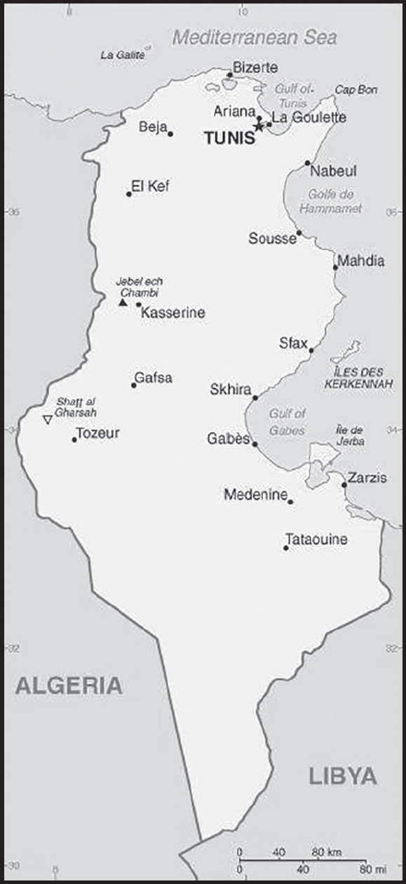
Location: Northern Africa, bordering the Mediterranean Sea, between Algeria and Libya
Geographic coordinates: 34 00 N, 9 00 E
Map references: Africa
Area: total: 163,610 sq km
land: 155,360 sq km
water: 8,250 sq km
comparison ranking: total 93
Area - comparative: slightly larger than Georgia
Land boundaries: total: 1,495 km
border countries (2): Algeria 1,034 km; Libya 461 km
Coastline: 1,148 km
Maritime claims: territorial sea: 12 nm
contiguous zone: 24 nm
exclusive economic zone: 12 nm
Climate: temperate in north with mild, rainy winters and hot, dry summers; desert in south
Terrain: mountains in north; hot, dry central plain; semiarid south merges into the Sahara
Elevation: highest point: Jebel ech Chambi 1,544 m
lowest point: Shatt al Gharsah -17 m
mean elevation: 246 m
Natural resources: petroleum, phosphates, iron ore, lead, zinc, salt
Land use: agricultural land: 64.8% (2018 est.)
arable land: 18.3% (2018 est.)
permanent crops: 15.4% (2018 est.)
permanent pasture: 31.1% (2018 est.)
forest: 6.6% (2018 est.)
other: 28.6% (2018 est.)
Irrigated land: 3,920 sq km (2013)
Major aquifers: North Western Sahara Aquifer System
Population distribution: the overwhelming majority of the population is located in the northern half of the country; the south remains largely underpopulated as shown in this population distribution map
Natural hazards: flooding; earthquakes; droughts
Geography - note: strategic location in central Mediterranean; Malta and Tunisia are discussing the commercial exploitation of the continental shelf between their countries, particularly for oil exploration
PEOPLE AND SOCIETY
Population: 11,976,182 (2023 est.)
comparison ranking: 81
Nationality: noun: Tunisian(s)
adjective: Tunisian
Ethnic groups: Arab 98%, European 1%, Jewish and other 1%
Languages: Arabic (official, one of the languages of commerce), French (commerce), Berber (Tamazight); note - despite having no official status, French plays a major role in the country and is spoken by about two thirds of the population
major-language sample(s):

(Arabic)
The World Factbook, une source indispensable d’informations de base. (French)
Religions: Muslim (official; Sunni) 99%, other (includes Christian, Jewish, Shia Muslim, and Baha’i) <1%
Demographic profile: The Tunisian Government took steps in the 1960s to decrease population growth and gender inequality in order to improve socioeconomic development. Through its introduction of a national family planning program (the first in Africa) and by raising the legal age of marriage, Tunisia rapidly reduced its total fertility rate from about 7 children per woman in 1960 to 2 in 2022. Unlike many of its North African and Middle Eastern neighbors, Tunisia will soon be shifting from being a youth-bulge country to having a transitional age structure, characterized by lower fertility and mortality rates, a slower population growth rate, a rising median age, and a longer average life expectancy.
Currently, the sizable young working-age population is straining Tunisia’s labor market and education and health care systems. Persistent high unemployment among Tunisia’s growing workforce, particularly its increasing number of university graduates and women, was a key factor in the uprisings that led to the overthrow of the BEN ALI regime in 2011. In the near term, Tunisia’s large number of jobless young, working-age adults; deficiencies in primary and secondary education; and the ongoing lack of job creation and skills mismatches could contribute to future unrest. In the longer term, a sustained low fertility rate will shrink future youth cohorts and alleviate demographic pressure on Tunisia’s labor market, but employment and education hurdles will still need to be addressed.
Tunisia has a history of labor emigration. In the 1960s, workers migrated to European countries to escape poor economic conditions and to fill Europe’s need for low-skilled labor in construction and manufacturing. The Tunisian Government signed bilateral labor agreements with France, Germany, Belgium, Hungary, and the Netherlands, with the expectation that Tunisian workers would eventually return home. At the same time, growing numbers of Tunisians headed to Libya, often illegally, to work in the expanding oil industry. In the mid-1970s, with European countries beginning to restrict immigration and Tunisian-Libyan tensions brewing, Tunisian economic migrants turned toward the Gulf countries. After mass expulsions from Libya in 1983, Tunisian migrants increasingly sought family reunification in Europe or moved illegally to southern Europe, while Tunisia itself developed into a transit point for Sub-Saharan migrants heading to Europe.
Following the ousting of BEN ALI in 2011, the illegal migration of unemployed Tunisian youths to Italy and onward to France soared into the tens of thousands. Thousands more Tunisian and foreign workers escaping civil war in Libya flooded into Tunisia and joined the exodus. A readmission agreement signed by Italy and Tunisia in April 2011 helped stem the outflow, leaving Tunisia and international organizations to repatriate, resettle, or accommodate some 1 million Libyans and third-country nationals.
Age structure: 0-14 years: 24.77% (male 1,529,179/female 1,436,771)
15-64 years: 65.26% (male 3,843,642/female 3,971,509)
65 years and over: 9.98% (2023 est.) (male 566,265/female 628,816)
Dependency ratios: total dependency ratio: 50.9
youth dependency ratio: 36.3
elderly dependency ratio: 13.3
potential support ratio: 7.5 (2021 est.)
Median age: total: 34 years (2023 est.)
male: 33.2 years
female: 34.7 years
comparison ranking: total 101
Population growth rate: 0.63% (2023 est.)
comparison ranking: 138
Birth rate: 14.1 births/1,000 population (2023 est.)
comparison ranking: 120
Death rate: 6.4 deaths/1,000 population (2023 est.)
comparison ranking: 142
Net migration rate: -1.3 migrant(s)/1,000 population (2023 est.)
comparison ranking: 154
Population distribution: the overwhelming majority of the population is located in the northern half of the country; the south remains largely underpopulated as shown in this population distribution map
Urbanization: urban population: 70.5% of total population (2023)
rate of urbanization: 1.34% annual rate of change (2020-25 est.)
Major urban areas - population: 2.475 million TUNIS (capital) (2023)
Sex ratio: at birth: 1.06 male(s)/female
0-14 years: 1.06 male(s)/female
15-64 years: 0.97 male(s)/female
65 years and over: 0.9 male(s)/female
total population: 0.98 male(s)/female (2023 est.)
Maternal mortality ratio: 37 deaths/100,000 live births (2020 est.)
comparison ranking: 108
Infant mortality rate: total: 11.6 deaths/1,000 live births (2023 est.)
male: 13 deaths/1,000 live births
female: 10.1 deaths/1,000 live births
comparison ranking: total 120
Life expectancy at birth: total population: 77.1 years (2023 est.)
male: 75.4 years
female: 78.8 years
comparison ranking: total population 93
Total fertility rate: 1.96 children born/woman (2023 est.)
comparison ranking: 113
Gross reproduction rate: 0.95 (2023 est.)
Contraceptive prevalence rate: 50.7% (2018)
Drinking water source: improved: urban: 100% of population
rural: 97.3% of population
total: 99.2% of population
unimproved: urban: 0% of population
rural: 2.7% of population
total: 0.8% of population (2020 est.)
Current health expenditure: 6.3% of GDP (2020)
Physicians density: 1.3 physicians/1,000 population (2017)
Hospital bed density: 2.2 beds/1,000 population (2017)
Sanitation facility access: improved: urban: 98.8% of population
rural: 99.4% of population
total: 99% of population
unimproved: urban: 1.2% of population
rural: 0.6% of population
total: 1% of population (2020 est.)
Obesity - adult prevalence rate: 26.9% (2016)
comparison ranking: 40
Alcohol consumption per capita: total: 1.51 liters of pure alcohol (2019 est.)
beer: 0.99 liters of pure alcohol (2019 est.)
wine: 0.32 liters of pure alcohol (2019 est.)
spirits: 0.17 liters of pure alcohol (2019 est.)
other alcohols: 0.03 liters of pure alcohol (2019 est.)
comparison ranking: total 139
Tobacco use: total: 24.6% (2020 est.)
male: 47.2% (2020 est.)
female: 2% (2020 est.)
comparison ranking: total 52
Children under the age of 5 years underweight: 1.6% (2018)
comparison ranking: 112
Currently married women (ages 15-49): 53.9% (2023 est.)
Child marriage: women married by age 15: 1.5% (2018 est.)
Education expenditures: 7.3% of GDP (2016 est.)
comparison ranking: 17
Literacy: definition: age 15 and over can read and write
total population: 82.7%
male: 89.1%
female: 82.7% (2021)
School life expectancy (primary to tertiary education): total: 15 years
male: 14 years
female: 16 years (2016)
Youth unemployment rate (ages 15-24): total: 38.3% (2021 est.)
male: 37.1%
female: 41.2%
comparison ranking: total 19
ENVIRONMENT
Environment - current issues: toxic and hazardous waste disposal is ineffective and poses health risks; water pollution from raw sewage; limited natural freshwater resources; deforestation; overgrazing; soil erosion; desertification
Environment - international agreements: party to: Biodiversity, Climate Change, Climate Change-Kyoto Protocol, Climate Change-Paris Agreement, Comprehensive Nuclear Test Ban, Desertification, Endangered Species, Environmental Modification, Hazardous Wastes, Law of the Sea, Marine Dumping-London Convention, Nuclear Test Ban, Ozone Layer Protection, Ship Pollution, Wetlands
signed, but not ratified: Marine Life Conservation
Climate: temperate in north with mild, rainy winters and hot, dry summers; desert in south
Land use: agricultural land: 64.8% (2018 est.)
arable land: 18.3% (2018 est.)
permanent crops: 15.4% (2018 est.)
permanent pasture: 31.1% (2018 est.)
forest: 6.6% (2018 est.)
other: 28.6% (2018 est.)
Urbanization: urban population: 70.5% of total population (2023)
rate of urbanization: 1.34% annual rate of change (2020-25 est.)
Revenue from forest resources: 0.21% of GDP (2018 est.)
comparison ranking: 92
Revenue from coal: 0% of GDP (2018 est.)
comparison ranking: 99
Air pollutants: particulate matter emissions: 26.52 micrograms per cubic meter (2019 est.)
carbon dioxide emissions: 29.94 megatons (2016 est.)
methane emissions: 7.89 megatons (2020 est.)
Waste and recycling: municipal solid waste generated annually: 2.7 million tons (2014 est.)
municipal solid waste recycled annually: 108,000 tons (2014 est.)
percent of municipal solid waste recycled: 4% (2014 est.)
Major aquifers: North Western Sahara Aquifer System
Total water withdrawal: municipal: 820 million cubic meters (2020 est.)
industrial: 60 million cubic meters (2020 est.)
agricultural: 2.71 billion cubic meters (2020 est.)
Total renewable water resources: 4.62 billion cubic meters (2020 est.)
GOVERNMENT
Country name: conventional long form: Republic of Tunisia
conventional short form: Tunisia
local long form: Al Jumhuriyah at Tunisiyah
local short form: Tunis
etymology: the country name derives from the capital city of Tunis
Government type: parliamentary republic
Capital: name: Tunis
geographic coordinates: 36 48 N, 10 11 E
time difference: UTC+1 (6 hours ahead of Washington, DC, during Standard Time)
etymology: three possibilities exist for the derivation of the name; originally a Berber settlement (earliest reference 4th century B.C.), the strategic site fell to the Carthaginians (Phoenicians) and the city could be named after the Punic goddess Tanit, since many ancient cities were named after patron deities; alternatively, the Berber root word “ens,” which means “to lie down” or “to pass the night,” may indicate that the site was originally a camp or rest stop; finally, the name may be the same as the city of Tynes, mentioned in the writings of some ancient authors
Administrative divisions: 24 governorates (wilayat, singular - wilayah); Beja (Bajah), Ben Arous (Bin ‘Arus), Bizerte (Banzart), Gabes (Qabis), Gafsa (Qafsah), Jendouba (Jundubah), Kairouan (Al Qayrawan), Kasserine (Al Qasrayn), Kebili (Qibili), Kef (Al Kaf), L’Ariana (Aryanah), Mahdia (Al Mahdiyah), Manouba (Manubah), Medenine (Madanin), Monastir (Al Munastir), Nabeul (Nabul), Sfax (Safaqis), Sidi Bouzid (Sidi Bu Zayd), Siliana (Silyanah), Sousse (Susah), Tataouine (Tatawin), Tozeur (Tawzar), Tunis, Zaghouan (Zaghwan)
Independence: 20 March 1956 (from France)
National holiday: Independence Day, 20 March (1956); Revolution and Youth Day, 14 January (2011)
Constitution: history: history: several previous; latest - draft published by the president 30 June 2022, approved by referendum 25 July, and adopted 27 July
amendments: proposed by the president of the republic or by one third of the Assembly of the Representatives of the People membership; following review by the Constitutional Court, approval to proceed requires an absolute majority vote by the Assembly and final passage requires a two-thirds majority vote by the Assembly; the president can opt to submit an amendment to a referendum, which requires an absolute majority of votes cast for passage
Legal system: mixed legal system of civil law, based on the French civil code and Islamic (sharia) law; some judicial review of legislative acts in the Supreme Court in joint session
International law organization participation: has not submitted an ICJ jurisdiction declaration; accepts ICCt jurisdiction
Citizenship: citizenship by birth: no
citizenship by descent only: at least one parent must be a citizen of Tunisia
dual citizenship recognized: yes
residency requirement for naturalization: 5 years
Suffrage: 18 years of age; universal except for active government security forces (including the police and the military), people with mental disabilities, people who have served more than three months in prison (criminal cases only), and people given a suspended sentence of more than six months
Executive branch: chief of state: President Kais SAIED (since 23 October 2019)
head of government: Prime Minister Ahmed HACHANI (since 1 August 2023)
cabinet: prime minister appointed by the president; cabinet members appointed by the president in consultation with the prime minister
elections/appointments: president directly elected by absolute majority popular vote in 2 rounds if needed for a 5-year term (eligible for a second term); last held on 15 September 2019 with a runoff on 13 October 2019 (next to be held in 2024)
election results: Kais SAIED elected president in second round; percent of vote in first round - Kais SAIED (independent) 18.4%, Nabil KAROUI (Heart of Tunisia) 15.6%, Abdelfattah MOUROU (Nahda Movement) 12.9%, Abdelkrim ZBIDI (independent) 10.7%, Youssef CHAHED (Long Live Tunisia) 7.4%, Safi SAID (independent) 7.1%, Lotfi MRAIHI (Republican People’s Union) 6.6%, other 21.3%; percent of vote in second round - Kais SAIED 72.7%, Nabil KAROUI 27.3%
note: the president can dismiss any member of government on his own initiative or in consultation with the prime minister
Legislative branch: description: bicameral legislature (enacted by the 2022 constitution) consists of:
newly added National Council of Regions and Districts (Le Conseil National des regions et des districts); (NA seats; members appointed by municipal-level councils; members of each Regional Council elect 3 members among themselves to the National Council; each District Council elects 1 member among themselves to the National Council; members serve 5-year term)
Assembly of Representatives of the People (161 seats; 151 members in single seat constituencies and 10 members from Tunisian diaspora directly elected by majoritarian two-round voting system; all members serve 5-year terms)
elections: National Council of Regions and Districts - dates of first appointments and indirect elections NA Assembly of Representatives of the People - last held on 17 December 2022 with a runoff on 29 January 2023 (next to be held in late 2027)
election results: note: in 2022 President SAIED issued a new electoral law which required all legislative candidates run as independents results NA; composition for 154 seats) - men 129, women 25, percent of women 15.2%
Judicial branch: highest court(s): Court of Cassation (consists of the first president, chamber presidents, and magistrates and organized into 27 civil and 11 criminal chambers)
judge selection and term of office: Supreme Court judges nominated by the Supreme Judicial Council, an independent 4-part body consisting mainly of elected judges and the remainder legal specialists; judge tenure based on terms of appointment; Constitutional Court (established in the 2014 and 2022 constitutions, but inception has been delayed; note - in mid-February 2022, President SAIED dissolved the Supreme Judicial Council and replaced it with an interim council in early March
subordinate courts: Courts of Appeal; administrative courts; Court of Audit; Housing Court; courts of first instance; lower district courts; military courts
note: the Tunisian constitution of January 2014 called for the establishment of a constitutional court by the end of 2015, but the court was never formed; the new constitution of July 2022 calls for the establishment of a constitutional court consisting of 9 members appointed by presidential decree; members to include former senior judges of other courts
Political parties and leaders: note - President SAIED in 2022 issued a decree that forbids political parties’ participation in legislative elections; although parties remain a facet of Tunisian political life, they have lost significant influence
Afek Tounes [Fadhel ABDELKEFI]
Al Badil Al-Tounisi (The Tunisian Alternative) [Mehdi JOMAA]
Al-Amal Party [Ridha BELHAJ]
Call for Tunisia Party (Nidaa Tounes) [Ali HAFSI]
Current of Love [Hachemi HAMDI] (formerly the Popular Petition party)
Democratic Current [Ghazi CHAOUACHI]
Democratic Patriots’ Unified Party [Zied LAKHDHAR]
Dignity Coalition or Al Karama Coalition [Seifeddine MAKHLOUF]
Ennahda Movement (The Renaissance) [Rached GHANNOUCHI]
Free Destourian Party or PDL [Abir MOUSSI]
Green Tunisia Party [Abdelkader ZITOUNI]
Heart of Tunisia (Qalb Tounes) [Nabil KAROUI]
Long Live Tunisia (Tahya Tounes) [Youssef CHAHED]
Machrou Tounes (Project Tunisia) [Mohsen MARZOUK]
Movement of Socialist Democrats or MDS [Ahmed KHASKHOUSSI]
Party of the Democratic Arab Vanguard [Kheireddine SOUABNI]
People’s Movement [Zouheir MAGHZAOUI]
Republican Party (Al Joumhouri) [Issam CHEBBI]
The Movement Party (Hizb Harak) [Moncef MARZOUKI]
Third Republic Party [Olfa HAMDI]
Tunisian Ba’ath Movement [Othmen Bel Haj AMOR]
Voice of the Republic [Ali HAFSI]
Workers’ Party [Hamma HAMMAMI]
International organization participation: ABEDA, AfDB, AFESD, AMF, AMU, AU, BSEC (observer), CAEU, CD, EBRD, FAO, G-11, G-77, IAEA, IBRD, ICAO, ICC (national committees), ICCt, ICRM, IDA, IDB, IFAD, IFC, IFRCS, IHO, ILO, IMF, IMO, IMSO, Interpol, IOC, IOM, IPU, ISO, ITSO, ITU, ITUC (NGOs), LAS, MIGA, MONUSCO, NAM, OAS (observer), OIC, OIF, OPCW, OSCE (partner), UN, UNCTAD, UNESCO, UNHCR, UNIDO, UNOCI, UNWTO, UPU, WCO, WFTU (NGOs), WHO, WIPO, WMO, WTO
Diplomatic representation in the US: chief of mission: Ambassador Hanene TAJOURI BESSASSI (since 1 December 2021)
chancery: 1515 Massachusetts Avenue NW, Washington, DC 20005
telephone: [1] (202) 862-1850
FAX: [1] (202) 862-1858
email address and website: AT.Washington@Tunisiaembassy.org
https://www.tunisianembassy.org/
Diplomatic representation from the US: chief of mission: Ambassador Joey HOOD (since 3 February 2023)
embassy: Les Berges du Lac, 1053 Tunis
mailing address: 6360 Tunis Place, Washington DC 20521-6360
telephone: [216] 71-107-000
FAX: [216] 71-107-090
email address and website: tunisacs@state.gov
Flag description: red with a white disk in the center bearing a red crescent nearly encircling a red five-pointed star; resembles the Ottoman flag (red banner with white crescent and star) and recalls Tunisia’s history as part of the Ottoman Empire; red represents the blood shed by martyrs in the struggle against oppression, white stands for peace; the crescent and star are traditional symbols of Islam
note: the flag is based on that of Turkey, itself a successor state to the Ottoman Empire
National symbol(s): encircled red crescent moon and five-pointed star; national colors: red, white
National anthem: name: “Humat Al Hima” (Defenders of the Homeland)
lyrics/music: Mustafa Sadik AL-RAFII and Aboul-Qacem ECHEBBI/Mohamad Abdel WAHAB
note: adopted 1957, replaced 1958, restored 1987; Mohamad Abdel WAHAB also composed the music for the anthem of the United Arab Emirates
National heritage: total World Heritage Sites: 9 (8 cultural, 1 natural)
selected World Heritage Site locales: Amphitheatre of El Jem (c); Archaeological Site of Carthage (c); Medina of Tunis (c); Ichkeul National Park (n); Punic Town of Kerkuane (c); Kairouan (c); Medina of Sousse (c); Dougga / Thugga (c); Djerba: Testimony to a settlement pattern in an island territory (c)
ECONOMY
Economic overview: lower middle-income North African economy; drafting reforms for foreign lenders; high unemployment, especially for youth and women; hit hard by COVID-19; high public sector wages; high public debt; protectionist austerity measures; key EU trade partner
Real GDP (purchasing power parity): $127.509 billion (2021 est.)
$122.226 billion (2020 est.)
$133.757 billion (2019 est.)
note: data are in 2017 dollars
comparison ranking: 83
Real GDP growth rate: 4.32% (2021 est.)
-8.62% (2020 est.)
1.5% (2019 est.)
comparison ranking: 107
Real GDP per capita: $10,400 (2021 est.)
$10,100 (2020 est.)
$11,100 (2019 est.)
note: data are in 2017 dollars
comparison ranking: 143
GDP (official exchange rate): $38.884 billion (2019 est.)
Inflation rate (consumer prices): 5.71% (2021 est.)
5.63% (2020 est.)
6.72% (2019 est.)
comparison ranking: 55
Credit ratings:
Fitch rating: B (2020)
Moody’s rating: B2 (2018)
Standard & Poors rating: N/A (2013)
note: The year refers to the year in which the current credit rating was first obtained.
GDP - composition, by sector of origin: agriculture: 10.1% (2017 est.)
industry: 26.2% (2017 est.)
services: 63.8% (2017 est.)
comparison rankings: services 100; industry 106; agriculture 90
GDP - composition, by end use: household consumption: 71.7% (2017 est.)
government consumption: 20.8% (2017 est.)
investment in fixed capital: 19.4% (2017 est.)
investment in inventories: 0% (2017 est.)
exports of goods and services: 43.2% (2017 est.)
imports of goods and services: -55.2% (2017 est.)
Agricultural products: wheat, milk, tomatoes, barley, olives, watermelons, green chillies/peppers, potatoes, dates, green onions/shallots
Industries: petroleum, mining (particularly phosphate, iron ore), tourism, textiles, footwear, agribusiness, beverages
Industrial production growth rate: 8.6% (2021 est.)
comparison ranking: 41
Labor force: 4.226 million (2021 est.)
comparison ranking: 95
Labor force - by occupation: agriculture: 14.8%
industry: 33.2%
services: 51.7% (2014 est.)
Unemployment rate: 16.82% (2021 est.)
16.59% (2020 est.)
15.13% (2019 est.)
comparison ranking: 27
Youth unemployment rate (ages 15-24): total: 38.3% (2021 est.)
male: 37.1%
female: 41.2%
comparison ranking: total 19
Population below poverty line: 15.2% (2015 est.)
Gini Index coefficient - distribution of family income: 32.8 (2015 est.)
comparison ranking: 127
Average household expenditures: on food: 21.9% of household expenditures (2018 est.)
on alcohol and tobacco: 3.2% of household expenditures (2018 est.)
Household income or consumption by percentage share: lowest 10%: 2.6%
highest 10%: 27% (2010 est.)
Budget: revenues: $10.866 billion (2019 est.)
expenditures: $12.375 billion (2019 est.)
Budget surplus (+) or deficit (-): -5.8% (of GDP) (2017 est.)
comparison ranking: 179
Public debt: 70.3% of GDP (2017 est.)
62.3% of GDP (2016 est.)
comparison ranking: 61
Taxes and other revenues: 24.7% (of GDP) (2017 est.)
comparison ranking: 53
Fiscal year: calendar year
Current account balance: -$2.781 billion (2021 est.)
-$2.533 billion (2020 est.)
-$3.391 billion (2019 est.)
comparison ranking: 169
Exports: $19.743 billion (2021 est.) note: data are in current year dollars
$16.017 billion (2020 est.) note: data are in current year dollars
$19.175 billion (2019 est.)
comparison ranking: 88
Exports - partners: France 29%, Italy 17%, Germany 13% (2019)
Exports - commodities: insulated wiring, clothing and apparel, crude petroleum, olive oil, vehicle parts (2019)
Imports: $24.269 billion (2021 est.) note: data are in current year dollars
$19.603 billion (2020 est.) note: data are in current year dollars
$23.546 billion (2019 est.)
comparison ranking: 82
Imports - partners: France 17%, Italy 16%, Germany 8%, China 8%, Algeria 7% (2019)
Imports - commodities: refined petroleum, natural gas, low-voltage protection equipment, cars, insulated wiring (2019)
Reserves of foreign exchange and gold: $8.846 billion (31 December 2021 est.)
$9.811 billion (31 December 2020 est.)
$7.92 billion (31 December 2019 est.)
comparison ranking: 87
Debt - external: $35.911 billion (2019 est.)
$33.79 billion (2018 est.)
comparison ranking: 79
Exchange rates: Tunisian dinars (TND) per US dollar -
Exchange rates: 2.794 (2021 est.)
2.812 (2020 est.)
2.934 (2019 est.)
2.647 (2018 est.)
2.419 (2017 est.)
ENERGY
Electricity access: population without electricity: (2020) less than 1 million
electrification - total population: 99.9% (2020)
electrification - urban areas: 100% (2021)
electrification - rural areas: 99.6% (2021)
Electricity: installed generating capacity: 5.777 million kW (2020 est.)
consumption: 16,737,180,000 kWh (2019 est.)
exports: 631 million kWh (2019 est.)
imports: 472 million kWh (2019 est.)
transmission/distribution losses: 3.641 billion kWh (2019 est.)
comparison rankings: installed generating capacity 81; transmission/distribution losses 58; imports 89; exports 71; consumption 77
Electricity generation sources: fossil fuels: 95.9% of total installed capacity (2020 est.)
solar: 1.3% of total installed capacity (2020 est.)
wind: 2.6% of total installed capacity (2020 est.)
hydroelectricity: 0.3% of total installed capacity (2020 est.)
Coal: production: 0 metric tons (2020 est.)
consumption: 5,000 metric tons (2020 est.)
exports: 0 metric tons (2020 est.)
imports: 5,000 metric tons (2020 est.)
proven reserves: 0 metric tons (2019 est.)
Petroleum: total petroleum production: 42,500 bbl/day (2021 est.)
refined petroleum consumption: 107,700 bbl/day (2019 est.)
crude oil and lease condensate exports: 29,400 bbl/day (2018 est.)
crude oil and lease condensate imports: 10,200 bbl/day (2018 est.)
crude oil estimated reserves: 425 million barrels (2021 est.)
Refined petroleum products - production: 27,770 bbl/day (2015 est.)
comparison ranking: 85
Refined petroleum products - exports: 13,660 bbl/day (2015 est.)
comparison ranking: 75
Refined petroleum products - imports: 85,340 bbl/day (2015 est.)
comparison ranking: 58
Natural gas: production: 1,025,974,000 cubic meters (2019 est.)
consumption: 5,279,951,000 cubic meters (2019 est.)
exports: 0 cubic meters (2021 est.)
imports: 4,305,994,000 cubic meters (2019 est.)
proven reserves: 65.129 billion cubic meters (2021 est.)
Carbon dioxide emissions: 23.692 million metric tonnes of CO2 (2019 est.)
from coal and metallurgical coke: 16,000 metric tonnes of CO2 (2019 est.)
from petroleum and other liquids: 12.982 million metric tonnes of CO2 (2019 est.)
from consumed natural gas: 10.694 million metric tonnes of CO2 (2019 est.)
comparison ranking: total emissions 81
Energy consumption per capita: 35.62 million Btu/person (2019 est.)
comparison ranking: 114
COMMUNICATIONS
Telephones - fixed lines: total subscriptions: 1.7 million (2021 est.)
subscriptions per 100 inhabitants: 14 (2021 est.)
comparison ranking: total subscriptions 57
Telephones - mobile cellular: total subscriptions: 16 million (2021 est.)
subscriptions per 100 inhabitants: 130 (2021 est.)
comparison ranking: total subscriptions 69
Telecommunication systems: general assessment: Tunisia has one of the most sophisticated telecom infrastructures in North Africa; penetration rates for mobile and Internet services are among the highest in the region; government program of regulation and infrastructure projects aims to improve Internet connectivity to underserved areas; operators built extensive LTE infrastructure in 2019, and continue to discuss plans for future 5G networks and services; one operator has signed an agreement to pursue nano-satellite launches in 2023; internet censorship abolished, though concerns of government surveillance remain; legislation passed in 2017 supporting e-commerce and active e-government; importer of some integrated circuits and broadcasting equipment (including radio, television, and communications transmitters) from the PRC (2022)
domestic: fixed-line is nearly 14 per 100 and mobile-cellular teledensity is 130 telephones per 100 persons (2021)
international: country code - 216; landing points for the SEA-ME-WE-4, Didon, HANNIBAL System and Trapani-Kelibia submarine cable systems that provides links to Europe, Africa, the Middle East, Asia and Southeast Asia; satellite earth stations - 1 Intelsat (Atlantic Ocean) and 1 Arabsat; coaxial cable and microwave radio relay to Algeria and Libya; participant in Medarabtel; 2 international gateway digital switches (2020)
Broadcast media: 2 state-owned TV stations; 10 private TV stations broadcast locally; satellite TV service is available; state-owned radio network with 2 stations; several dozen private radio stations and community radio stations; transmissions of multiple international broadcasters available (2019)
Internet country code: .tn
Internet users: total: 9.48 million (2021 est.)
percent of population: 79% (2021 est.)
comparison ranking: total 60
Broadband - fixed subscriptions: total: 1,334,059 (2020 est.)
subscriptions per 100 inhabitants: 11 (2020 est.)
comparison ranking: total 67
TRANSPORTATION
National air transport system: number of registered air carriers: 7 (2020)
inventory of registered aircraft operated by air carriers: 53
annual passenger traffic on registered air carriers: 4,274,199 (2018)
annual freight traffic on registered air carriers: 13.23 million (2018) mt-km
Civil aircraft registration country code prefix: TS
Airports: 29 (2021)
comparison ranking: total 119
Airports - with paved runways: 15
note: paved runways have a concrete or asphalt surface but not all have facilities for refueling, maintenance, or air traffic control; the length of a runway required for aircraft to safely operate depends on a number of factors including the type of aircraft, the takeoff weight (including passengers, cargo, and fuel), engine types, flap settings, landing speed, elevation of the airport, and average maximum daily air temperature; paved runways can reach a length of 5,000 m (16,000 ft.), but the “typical” length of a commercial airline runway is between 2,500-4,000 m (8,000-13,000 ft.)
Airports - with unpaved runways: 14
note: unpaved runways have a surface composition such as grass or packed earth and are most suited to the operation of light aircraft; unpaved runways are usually short, often less than 1,000 m (3,280 ft.) in length; airports with unpaved runways often lack facilities for refueling, maintenance, or air traffic control
Pipelines: 68 km condensate, 3,111 km gas, 1,381 km oil, 453 km refined products (2013)
Railways: total: 2,173 km (2014) (1,991 in use)
standard gauge: 471 km (2014) 1.435-m gauge
narrow gauge: 1,694 km (2014) 1.000-m gauge (65 km electrified)
dual gauge: 8 km (2014) 1.435-1.000-m gauge
comparison ranking: total 70
Roadways: paved: 20,000 km (2015)
Merchant marine: total: 70 (2022)
by type: container ship 1, general cargo 8, oil tanker 1, other 60
comparison ranking: total 108
Ports and terminals: major seaport(s): Bizerte, Gabes, Rades, Sfax, Skhira
MILITARY AND SECURITY
Military and security forces: Tunisian Armed Forces (Forces Armées Tunisiennes, FAT): Tunisian Army (includes Air Defense Force), Tunisian Navy, Tunisia Air Force
Ministry of Interior: National Police, National Guard (2023)
note: the National Police has primary responsibility for law enforcement in the major cities, while the National Guard (gendarmerie) oversees border security and patrols smaller towns and rural areas
Military expenditures: 2.7% of GDP (2022 est.)
3% of GDP (2021 est.)
3% of GDP (2020 est.)
3.8% of GDP (2019 est.)
3.9% of GDP (2018 est.)
comparison ranking: 35
Military and security service personnel strengths: approximately 35,000 active-duty personnel (25,000 Army; 5,000 Navy; 5,000 Air Force); estimated 10,000 National Guard (2023)
Military equipment inventories and acquisitions: the Tunisian military’s inventory includes mostly older or second-hand US and European equipment; in recent years, the Netherlands, Turkey, and US have been the leading suppliers of arms to Tunisia (2023)
Military service age and obligation: 20-23 years of age for compulsory service for men with a 12-month service obligation; individuals engaged in higher education or vocational training programs prior to their military drafting are allowed to delay service until they have completed their programs (up to age 35); 18-23 years of age for voluntary service for men and women (2023)
note 1: as of 2021, approximately 20-25,000 active military personnel were conscripts
note 2: women have been allowed in the service since 1975 as volunteers only, although as recently as 2018, the Tunisian Government has discussed the possibility of conscripting women; as of 2018, women constituted less than 7% of the military and served in all three services
Military deployments: 775 Central African Republic (MINUSCA); 100 Mali (MINUSMA) (2023)
Military - note: the FAT is responsible for territorial defense and internal security; its operational areas of focus are countering Islamic terrorist groups and assisting with securing the border; it is conducting counterterrorism and counterinsurgency operations against militant groups linked to al-Qa’ida in the Islamic Maghreb (AQIM) and the Islamic State of ash-Sham (ISIS) who are fighting a low-intensity insurgency, mostly in the mountainous region along the border with Algeria, particularly the Chaambi Mountains near the city of Kasserine; the military has the lead role for security in this area and also routinely conducts joint operations with Algerian security forces against these groups, as well to counter smuggling and trafficking activities; the FAT in recent years also has increased its role in securing the southern border against militant activity, smuggling, and trafficking from war-torn Libya; since 2015, Tunisia has constructed a system of berms, trenches, and water-filled moats, complemented by electronic surveillance equipment such as motion detectors, ground surveillance radars, and infrared sensors along the 220-kilometer border with Libya; in the remote southern areas of the border with Libya, buffer/exclusion zones have also been established where the military has the lead for counterterrorism efforts; outside of these border areas, the Ministry of Interior (MOI) has the responsibility for counterterrorism, particularly for urban areas; the National Police Anti-Terrorism Brigade and the National Guard Special Unit have the lead for MOI counterterrorism operations
the FAT is a conscript-based, but professional force that has historically remained largely apolitical and stayed out of the country’s economy; following Tunisia’s 1956 independence, FAT officers were legally prohibited from joining political parties, and the military did not intervene to prop up BEN ALI in 2011; nevertheless, President SAIED’s use of military courts to try civilians and placement of military troops outside of the parliament building after he dissolved the Assembly has raised concerns of military politicization
the FAT conducts bilateral and multinational training exercises with a variety of countries, including Algeria and other North African and Middle Eastern countries, France, and the US, as well as NATO; it also participates in UN peacekeeping operations; the Army has 5 combat brigades, including 3 mechanized infantry, a desert patrol, and a special forces brigade, as well as an armored reconnaissance regiment; the Navy is a coastal defense force with a small inventory of offshore patrol ships complemented by a mix of fast attack and patrol craft; the Air Force largely supports the Army’s operations; it has a handful of older US-made fighter aircraft and a few dozen combat helicopters, mostly of French and US origin
Tunisia has Major Non-NATO Ally (MNNA) status with the US, a designation under US law that provides foreign partners with certain benefits in the areas of defense trade and security cooperation (2023)
SPACE
Space agency/agencies: the National Center of Cartography and Remote Sensing (Centre National de la Cartographie et de la Télédétection or CNCT; established in 1988 and directs Tunisia’s space activities; is a non-administrative public company under the supervision of the Ministry of Defense); Tunisian National Commission for Outer Space Affairs (NCOSA; established 1984 to oversee the space-related activities of government ministries); note – the Tunisian Space Agency is a non-profit, non-governmental scientific association created in June 2012 to promote the field of aerospace in Tunisia (2023)
Space program overview: has a small space program with a focus on exploiting satellite imagery and developing small satellites and satellite components; has established relations with a variety of foreign space agencies and industries, including those of Brazil, China, France, Japan, and Russia (2023)
note: further details about the key activities, programs, and milestones of the country’s space program, as well as government spending estimates on the space sector, appear in Appendix S
TERRORISM
Terrorist group(s): Terrorist group(s): Ansar al-Sharia in Tunisia; Islamic State of Iraq and ash-Sham (ISIS) network in Tunisia (known locally as Ajnad al-Khilafah or the Army of the Caliphate); al-Qa’ida in the Islamic Maghreb
note: details about the history, aims, leadership, organization, areas of operation, tactics, targets, weapons, size, and sources of support of the group(s) appear(s) in Appendix-T
TRANSNATIONAL ISSUES
Disputes - international: none identified
Illicit drugs: NA
TURKEY (TURKIYE)
INTRODUCTION
Background: Modern Turkey was founded in 1923 from the remnants of the defeated Ottoman Empire by national hero Mustafa KEMAL, who was later honored with the title Ataturk or “Father of the Turks.” Under his leadership, the country adopted radical social, legal, and political reforms. After a period of one-party rule, an experiment with multi-party politics led to the 1950 election victory of the opposition Democrat Party and the peaceful transfer of power. Since then, Turkish political parties have multiplied, but democracy has been fractured by periods of instability and military coups (1960, 1971, 1980), which in each case eventually resulted in a return of formal political power to civilians. In 1997, the military again helped engineer the ouster - popularly dubbed a “post-modern coup” - of the then Islamic-oriented government. An unsuccessful coup attempt was made in July 2016 by a faction of the Turkish Armed Forces.
Turkey intervened militarily on Cyprus in 1974 to prevent a Greek takeover of the island and has since acted as patron state to the “Turkish Republic of Northern Cyprus,” which only Turkey recognizes. A separatist insurgency begun in 1984 by the Kurdistan Workers’ Party (PKK), a US-designated terrorist organization, has long dominated the attention of Turkish security forces and claimed more than 40,000 lives. In 2013, the Turkish Government and the PKK conducted negotiations aimed at ending the violence, however intense fighting resumed in 2015. Turkey joined the UN in 1945 and in 1952 it became a member of NATO. In 1963, Turkey became an associate member of the European Community; it began accession talks with the EU in 2005. Over the past decade, economic reforms, coupled with some political reforms, have contributed to a growing economy, although in recent years, the government’s growth-by-any-means strategy has sent inflation to historic highs and tested the broader financial system’s resilience.
From 2015 and continuing through 2016, Turkey witnessed an uptick in terrorist violence, including major attacks in Ankara, Istanbul, and throughout the predominantly Kurdish southeastern region of Turkey. On 15 July 2016, elements of the Turkish Armed forces attempted a coup that ultimately failed following widespread popular resistance. More than 240 people were killed and over 2,000 injured when Turkish citizens took to the streets en masse to confront the coup forces. The government accused followers of the Fethullah Gulen transnational religious and social movement (“Hizmet”) of instigating the failed coup and designates the movement’s followers as terrorists. Since the attempted coup, Turkish Government authorities arrested, suspended, or dismissed more than 130,000 security personnel, journalists, judges, academics, and civil servants due to their alleged connection to Gulen’s movement. Following the failed coup, the Turkish Government instituted a State of Emergency from July 2016 to July 2018. The Turkish Government conducted a referendum on 16 April 2017 in which voters approved constitutional amendments changing Turkey from a parliamentary to a presidential system. The amendments went into effect fully following the presidential and parliamentary elections in June 2018.
GEOGRAPHY
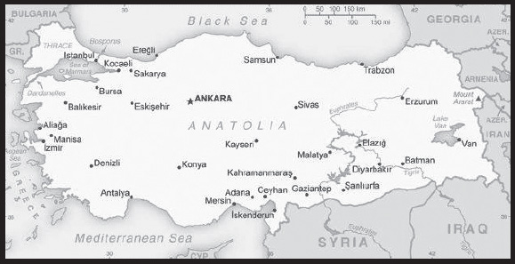
Location: Southeastern Europe and Southwestern Asia (that portion of Turkey west of the Bosporus is geographically part of Europe), bordering the Black Sea, between Bulgaria and Georgia, and bordering the Aegean Sea and the Mediterranean Sea, between Greece and Syria
Geographic coordinates: 39 00 N, 35 00 E
Map references: Middle East
Area: total: 783,562 sq km
land: 769,632 sq km
water: 13,930 sq km
comparison ranking: total 38
Area - comparative: slightly larger than Texas
Land boundaries: total: 2,816 km
border countries (8): Armenia 311 km; Azerbaijan 17 km; Bulgaria 223 km; Georgia 273 km; Greece 192 km; Iran 534 km; Iraq 367 km; Syria 899 km
Coastline: 7,200 km
Maritime claims: territorial sea: 6 nm in the Aegean Sea
exclusive economic zone: in Black Sea only: to the maritime boundary agreed upon with the former USSR
12 nm in Black Sea and in Mediterranean Sea
Climate: temperate; hot, dry summers with mild, wet winters; harsher in interior
Terrain: high central plateau (Anatolia); narrow coastal plain; several mountain ranges
Elevation: highest point: Mount Ararat 5,137 m
lowest point: Mediterranean Sea 0 m
mean elevation: 1,132 m
Natural resources: coal, iron ore, copper, chromium, antimony, mercury, gold, barite, borate, celestite (strontium), emery, feldspar, limestone, magnesite, marble, perlite, pumice, pyrites (sulfur), clay, arable land, hydropower
Land use: agricultural land: 49.7% (2018 est.)
arable land: 26.7% (2018 est.)
permanent crops: 4% (2018 est.)
permanent pasture: 19% (2018 est.)
forest: 14.9% (2018 est.)
other: 35.4% (2018 est.)
Irrigated land: 52,150 sq km (2020)
Major lakes (area sq km): fresh water lake(s): Lake Beysehir - 650 sq km; Lake Egridir - 520 sq km
salt water lake(s): Lake Van - 3,740 sq km; Lake Tuz - 1,640 sq km;
Major rivers (by length in km): Euphrates river source (shared with Syria, Iran, and Iraq [m]) - 3,596 km; Tigris river source (shared with Syria, Iran, and Iraq [m]) - 1,950 km
note – [s] after country name indicates river source; [m] after country name indicates river mouth
Major watersheds (area sq km): Indian Ocean drainage: (Persian Gulf) Tigris and Euphrates (918,044 sq km)
Population distribution: the most densely populated area is found around the Bosporus in the northwest where 20% of the population lives in Istanbul; with the exception of Ankara, urban centers remain small and scattered throughout the interior of Anatolia; an overall pattern of peripheral development exists, particularly along the Aegean Sea coast in the west, and the Tigris and Euphrates River systems in the southeast
Natural hazards: severe earthquakes, especially in northern Turkey, along an arc extending from the Sea of Marmara to Lake Van; landslides; flooding
volcanism: limited volcanic activity; its three historically active volcanoes; Ararat, Nemrut Dagi, and Tendurek Dagi have not erupted since the 19th century or earlier
Geography - note: strategic location controlling the Turkish Straits (Bosporus, Sea of Marmara, Dardanelles) that link the Black and Aegean Seas; the 3% of Turkish territory north of the Straits lies in Europe and goes by the names of European Turkey, Eastern Thrace, or Turkish Thrace; the 97% of the country in Asia is referred to as Anatolia; Istanbul, which straddles the Bosporus, is the only metropolis in the world located on two continents; Mount Ararat, the legendary landing place of Noah’s ark, is in the far eastern portion of the country
PEOPLE AND SOCIETY
Population: 83,593,483 (2023 est.)
comparison ranking: 19
Nationality: noun: Turk(s)
adjective: Turkish
Ethnic groups: Turkish 70-75%, Kurdish 19%, other minorities 6-11% (2016 est.)
Languages: Turkish (official), Kurdish, other minority languages
major-language sample(s): The World Factbook, temel bilgi edinmek için vazgeçilmez bir kaynak. (Turkish)

Religions: Muslim 99.8% (mostly Sunni), other 0.2% (mostly Christians and Jews)
Age structure: 0-14 years: 22.12% (male 9,459,277/female 9,029,296)
15-64 years: 68.58% (male 29,023,477/female 28,301,263)
65 years and over: 9.31% (2023 est.) (male 3,512,598/female 4,267,572)
Dependency ratios: total dependency ratio: 49.1
youth dependency ratio: 34.5
elderly dependency ratio: 12.3
potential support ratio: 8.1 (2021 est.)
Median age: total: 33.6 years (2023 est.)
male: 33 years
female: 34.1 years
comparison ranking: total 106
Population growth rate: 0.64% (2023 est.)
comparison ranking: 135
Birth rate: 14 births/1,000 population (2023 est.)
comparison ranking: 121
Death rate: 6.1 deaths/1,000 population (2023 est.)
comparison ranking: 155
Net migration rate: -1.5 migrant(s)/1,000 population (2023 est.)
comparison ranking: 157
Population distribution: the most densely populated area is found around the Bosporus in the northwest where 20% of the population lives in Istanbul; with the exception of Ankara, urban centers remain small and scattered throughout the interior of Anatolia; an overall pattern of peripheral development exists, particularly along the Aegean Sea coast in the west, and the Tigris and Euphrates River systems in the southeast
Urbanization: urban population: 77.5% of total population (2023)
rate of urbanization: 1.11% annual rate of change (2020-25 est.)
Major urban areas - population: 15.848 million Istanbul, 5.397 million ANKARA (capital), 3.088 million Izmir, 2.086 million Bursa, 1.836 million Adana, 1.805 million Gaziantep (2023)
Sex ratio: at birth: 1.05 male(s)/female
0-14 years: 1.05 male(s)/female
15-64 years: 1.03 male(s)/female
65 years and over: 0.82 male(s)/female
total population: 1.01 male(s)/female (2023 est.)
Mother’s mean age at first birth: 26.6 years (2020 est.)
Maternal mortality ratio: 17 deaths/100,000 live births (2020 est.)
comparison ranking: 130
Infant mortality rate: total: 18.9 deaths/1,000 live births (2023 est.)
male: 20.5 deaths/1,000 live births
female: 17.2 deaths/1,000 live births
comparison ranking: total 82
Life expectancy at birth: total population: 76.5 years (2023 est.)
male: 74.1 years
female: 78.9 years
comparison ranking: total population 100
Total fertility rate: 1.91 children born/woman (2023 est.)
comparison ranking: 120
Gross reproduction rate: 0.93 (2023 est.)
Contraceptive prevalence rate: 69.8% (2018)
Drinking water source: improved: urban: 99.1% of population
rural: 98.7% of population
total: 99% of population
unimproved: urban: 0.9% of population
rural: 1.3% of population
total: 1% of population (2020 est.)
Current health expenditure: 4.6% of GDP (2020)
Physicians density: 1.93 physicians/1,000 population (2019)
Hospital bed density: 2.9 beds/1,000 population (2018)
Sanitation facility access: improved: urban: 99.8% of population
rural: 98.7% of population
total: 99.6% of population
unimproved: urban: 0.2% of population
rural: 1.3% of population
total: 0.4% of population (2020 est.)
Obesity - adult prevalence rate: 32.1% (2016)
comparison ranking: 17
Alcohol consumption per capita: total: 1.18 liters of pure alcohol (2019 est.)
beer: 0.67 liters of pure alcohol (2019 est.)
wine: 0.16 liters of pure alcohol (2019 est.)
spirits: 0.35 liters of pure alcohol (2019 est.)
other alcohols: 0 liters of pure alcohol (2019 est.)
comparison ranking: total 147
Tobacco use: total: 30.7% (2020 est.)
male: 42.1% (2020 est.)
female: 19.2% (2020 est.)
comparison ranking: total 28
Children under the age of 5 years underweight: 1.5% (2018/19)
comparison ranking: 113
Currently married women (ages 15-49): 65.4% (2023 est.)
Child marriage: women married by age 15: 2%
women married by age 18: 14.7% (2018 est.)
Education expenditures: 3.4% of GDP (2020 est.)
comparison ranking: 145
Literacy: definition: age 15 and over can read and write
total population: 96.7%
male: 99.1%
female: 94.4% (2019)
School life expectancy (primary to tertiary education): total: 18 years
male: 19 years
female: 18 years (2020)
Youth unemployment rate (ages 15-24): total: 24.3% (2021 est.)
male: 21.4%
female: 29.9%
comparison ranking: total 65
ENVIRONMENT
Environment - current issues: water pollution from dumping of chemicals and detergents; air pollution, particularly in urban areas; deforestation; land degradation; concern for oil spills from increasing Bosporus ship traffic; conservation of biodiversity
Environment - international agreements: party to: Air Pollution, Antarctic-Environmental Protection, Antarctic Treaty, Biodiversity, Climate Change, Climate Change-Kyoto Protocol, Comprehensive Nuclear Test Ban, Desertification, Endangered Species, Hazardous Wastes, Nuclear Test Ban, Ozone Layer Protection, Ship Pollution, Wetlands
signed, but not ratified: Climate Change-Paris Agreement, Environmental Modification
Climate: temperate; hot, dry summers with mild, wet winters; harsher in interior
Land use: agricultural land: 49.7% (2018 est.)
arable land: 26.7% (2018 est.)
permanent crops: 4% (2018 est.)
permanent pasture: 19% (2018 est.)
forest: 14.9% (2018 est.)
other: 35.4% (2018 est.)
Urbanization: urban population: 77.5% of total population (2023)
rate of urbanization: 1.11% annual rate of change (2020-25 est.)
Revenue from forest resources: 0.08% of GDP (2018 est.)
comparison ranking: 118
Revenue from coal: 0.05% of GDP (2018 est.)
comparison ranking: 31
Air pollutants: particulate matter emissions: 23.25 micrograms per cubic meter (2019 est.)
carbon dioxide emissions: 372.72 megatons (2016 est.)
methane emissions: 57.53 megatons (2020 est.)
Waste and recycling: municipal solid waste generated annually: 31.283 million tons (2015 est.)
Major lakes (area sq km): fresh water lake(s): Lake Beysehir - 650 sq km; Lake Egridir - 520 sq km
salt water lake(s): Lake Van - 3,740 sq km; Lake Tuz - 1,640 sq km;
Major rivers (by length in km): Euphrates river source (shared with Syria, Iran, and Iraq [m]) - 3,596 km; Tigris river source (shared with Syria, Iran, and Iraq [m]) - 1,950 km
note – [s] after country name indicates river source; [m] after country name indicates river mouth
Major watersheds (area sq km): Indian Ocean drainage: (Persian Gulf) Tigris and Euphrates (918,044 sq km)
Total water withdrawal: municipal: 6.91 billion cubic meters (2020 est.)
industrial: 1.03 billion cubic meters (2020 est.)
agricultural: 54.27 billion cubic meters (2020 est.)
Total renewable water resources: 211.6 billion cubic meters (2020 est.)
GOVERNMENT
Country name: conventional long form: Republic of Turkey
conventional short form: Turkey
local long form: Turkey Cumhuriyeti
local short form: Turkey
etymology: the name means “Land of the Turks”
note: Turkiye is an approved English short-form name for Turkey
Government type: presidential republic
Capital: name: Ankara
geographic coordinates: 39 56 N, 32 52 E
time difference: UTC+3 (8 hours ahead of Washington, DC, during Standard Time)
etymology: Ankara has been linked with a second millennium B.C. Hittite cult center of Ankuwash, although this connection is uncertain; in classical and medieval times, the city was known as Ankyra (meaning “anchor” in Greek and reflecting the city’s position as a junction for multiple trade and military routes); by about the 13th century the city began to be referred to as Angora; following the establishment of the Republic of Turkey in 1923, the city’s name became Ankara
Administrative divisions: 81 provinces (iller, singular - ili); Adana, Adiyaman, Afyonkarahisar, Agri, Aksaray, Amasya, Ankara, Antalya, Ardahan, Artvin, Aydin, Balikesir, Bartin, Batman, Bayburt, Bilecik, Bingol, Bitlis, Bolu, Burdur, Bursa, Canakkale, Cankiri, Corum, Denizli, Diyarbakir, Duzce, Edirne, Elazig, Erzincan, Erzurum, Eskisehir, Gaziantep, Giresun, Gumushane, Hakkari, Hatay, Igdir, Isparta, Istanbul, Izmir (Smyrna), Kahramanmaras, Karabuk, Karaman, Kars, Kastamonu, Kayseri, Kilis, Kirikkale, Kirklareli, Kirsehir, Kocaeli, Konya, Kutahya, Malatya, Manisa, Mardin, Mersin, Mugla, Mus, Nevsehir, Nigde, Ordu, Osmaniye, Rize, Sakarya, Samsun, Sanliurfa, Siirt, Sinop, Sirnak, Sivas, Tekirdag, Tokat, Trabzon (Trebizond), Tunceli, Usak, Van, Yalova, Yozgat, Zonguldak
Independence: 29 October 1923 (republic proclaimed, succeeding the Ottoman Empire)
National holiday: Republic Day, 29 October (1923)
Constitution: history: several previous; latest ratified 9 November 1982
amendments: proposed by written consent of at least one third of Grand National Assembly (GNA) of Turkey (TBMM) members; adoption of draft amendments requires two debates in plenary TBMM session and three-fifths majority vote of all GNA members; the president of the republic can request TBMM reconsideration of the amendment and, if readopted by two-thirds majority TBMM vote, the president may submit the amendment to a referendum; passage by referendum requires absolute majority vote; amended several times, last in 2017
Legal system: civil law system based on various European legal systems, notably the Swiss civil code
International law organization participation: has not submitted an ICJ jurisdiction declaration; non-party state to the ICCt
Citizenship: citizenship by birth: no
citizenship by descent only: at least one parent must be a citizen of Turkey
dual citizenship recognized: yes, but requires prior permission from the government
residency requirement for naturalization: 5 years
Suffrage: 18 years of age; universal
Executive branch: chief of state: President Recep Tayyip ERDOGAN (chief of state since 28 August 2014; head of government since 9 July 2018); Vice President Cevdet YILMAZ (since 3 June 2023); note - the president is both chief of state and head of government
head of government: President Recep Tayyip ERDOGAN (head of government since 9 July 2018; chief of state since 28 August 2014)
cabinet: Council of Ministers appointed by the president
elections/appointments: president directly elected by absolute majority popular vote in 2 rounds if needed for a 5-year term (eligible for a second term); election last held on 14 May 2023 with a runoff on 28 May 2023 (next to be held in 2028)
election results: 2023: Recep Tayyip ERDOGAN reelected in second round - Recep Tayyip ERDOGAN (AKP) 52.2%, Kemal KILICDAROGLU (CHP) 47.8%
2018: Recep Tayyip ERDOGAN reelected president in first round - Recep Tayyip ERDOGAN (AKP) 52.6%, Muharrem INCE (CHP) 30.6%, Selahattin DEMIRTAS (HDP) 8.4%, Meral AKSENER (IYI) 7.3%, other 1.1%
Legislative branch: description: unicameral Grand National Assembly of Turkey or Turkey Buyuk Millet Meclisi (600 seats); members directly elected in multi-seat constituencies by closed party-list proportional representation vote, with a 10% threshold required to win a seat; members serve 5-year terms)
elections: last held on 14 May 2023 (next to be held in 2028)
election results: percent of vote by party/coalition - People’s Alliance 49.9% (AKP 35.6%, MHP 10.1%, YRP 2.8%, BBP 1%), Nation Alliance 35.4% (CHP 25.3%, IYI 9.7%), Labor and Freedom Alliance 10.7% (YSGP 8.9%, TIP 1.8%); seats by party/coalition - People’s Alliance 323 (AKP 268, MHP 50, YRP 5), Nation Alliance 212 (CHP 169, IYI 43), Labor and Freedom Alliance 65 (YSGP 61, TIP 4); composition - men 479, women 121, percent of women 20.2%
Judicial branch: highest court(s): Constitutional Court or Anayasa Mahkemesi (consists of the president, 2 vice presidents, and 12 judges); Court of Cassation (consists of about 390 judges and is organized into civil and penal chambers); Council of State (organized into 15 divisions - 14 judicial and 1 consultative - each with a division head and at least 5 members)
judge selection and term of office: Constitutional Court members - 3 appointed by the Grand National Assembly and 12 by the president of the republic; court president and 2 deputy court presidents appointed from among its members for 4-year terms; judges serve 12-year, nonrenewable terms with mandatory retirement at age 65; Court of Cassation judges appointed by the Board of Judges and Prosecutors, a 13-member body of judicial officials; Court of Cassation judges serve until retirement at age 65; Council of State members appointed by the Board and by the president of the republic; members serve renewable, 4-year terms
subordinate courts: regional appeals courts; basic (first instance) courts; peace courts; aggravated crime courts; specialized courts, including administrative and audit; note - a constitutional amendment in 2017 abolished military courts unless established to investigate military personnel actions during war conditions
Political parties and leaders: Democracy and Progress Party or DEVA [Ali BABACAN]
Democrat Party or DP [Gultekin UYSAL]
Democratic Regions Party or DBP [Saliha AYDENIZ, Keskin BAYINDIR]
Felicity Party (Saadet Party) or SP [Temel KARAMOLLAOGLU]
Free Cause Party or HUDA PAR [Zekeriya YAPICIOGLU]
Future Party (Gelecek Partisi) or GP [Ahmet DAVUTOGLU]
Good Party or IYI [Meral AKSENER]
Grand Unity Party or BBP [Mustafa DESTICI]
Justice and Development Party or AKP [Recep Tayyip ERDOGAN]
Labor and Freedom Alliance (electoral alliance includes YSGP, HDP, TIP)
Nation Alliance [collective leadership] (electoral alliance includes CHP, DEVA, DP, GP, IYI, SP) (dissolved 1 June 2023)
Nationalist Movement Party or MHP [Devlet BAHCELI]
New Welfare Party or YRP [Fatih ERBAKAN]
Party of Greens and the Left Future or YSGP [Cigfrm Kilicgun UCAR and Ibrahim AKIN]
People’s Alliance (electoral alliance includes AKP, BBP, MHP, YRP)
Peoples’ Democratic Party or HDP [Pervin BULDAN, Mithat SANCAR]
Republican People’s Party or CHP [Kemal KILICDAROGLU]
Workers’ Party of Turkey or TIP [Erkan BAS]
note: as of September 2021, 116 political parties were legally registered
International organization participation: ADB (nonregional member), Australia Group, BIS, BSEC, CBSS (observer), CD, CE, CERN (observer), CICA, CPLP (associate observer), D-8, EAPC, EBRD, ECO, EU (candidate country), FAO, FATF, G-20, IAEA, IBRD, ICAO, ICC (national committees), ICRM, IDA, IDB, IEA, IFAD, IFC, IFRCS, IHO, ILO, IMF, IMO, IMSO, Interpol, IOC, IOM, IPU, ISO, ITSO, ITU, ITUC (NGOs), MIGA, NATO, NEA, NSG, OAS (observer), OECD, OIC, OPCW, OSCE, Pacific Alliance (observer), Paris Club (associate), PCA, PIF (partner), SCO (dialogue member), SELEC, UN, UNCTAD, UNESCO, UNHCR, UNIDO, UNIFIL, UNRWA, UNWTO, UPU, Wassenaar Arrangement, WCO, WFTU (NGOs), WHO, WIPO, WMO, WTO, ZC
note: Turkey is an EU candidate country whose satisfactory completion of accession criteria is required before being granted full EU membership
Diplomatic representation in the US: chief of mission: Ambassador Hasan Murat MERCAN (since 20 April 2021)
chancery: 2525 Massachusetts Avenue NW, Washington, DC 20008
telephone: [1] (202) 612-6700
FAX: [1] (202) 612-6744
email address and website: embassy.washingtondc@mfa.gov.tr
http://washington.emb.mfa.gov.tr/Mission
consulate(s) general: Boston, Chicago, Houston, Los Angeles, Miami, New York
Diplomatic representation from the US: chief of mission: Ambassador Jeffry Lane FLAKE (since 26 January 2022)
embassy: 1480 Sokak No. 1, Cukurambar Mahallesi, 06530 Cankaya, Ankara
mailing address: 7000 Ankara Place, Washington DC 20512-7000
telephone: [90] (312) 294-0000
FAX: [90] (312) 467-0019
email address and website: Ankara-ACS@state.gov
consulate(s) general: Istanbul
consulate(s): Adana
Flag description: red with a vertical white crescent moon (the closed portion is toward the hoist side) and white five-pointed star centered just outside the crescent opening; the flag colors and designs closely resemble those on the banner of the Ottoman Empire, which preceded modern-day Turkey; the crescent moon and star serve as insignia for Turkic peoples; according to one interpretation, the flag represents the reflection of the moon and a star in a pool of blood of Turkish warriors
National symbol(s): vertical crescent moon with adjacent five-pointed star; national colors: red, white
National anthem: name: “Istiklal Marsi” (Independence March)
lyrics/music: Mehmet Akif ERSOY/Zeki UNGOR
note: lyrics adopted 1921, music adopted 1932; the anthem’s original music was adopted in 1924; a new composition was agreed upon in 1932
National heritage: total World Heritage Sites: 19 (17 cultural, 2 mixed)
selected World Heritage Site locales: Archaeological Site of Troy (c); Ephesus (c); Diyarbakır Fortress and Hevsel Gardens Cultural Landscape (c); Hierapolis-Pamukkale (m); Göreme National Park and the Rock Sites of Cappadocia (m); Göbekli Tepe (c); Historic Areas of Istanbul (c); Selimiye Mosque and its Social Complex (c); Neolithic Site of Çatalhöyük (c); Bursa and Cumalıkızık: the Birth of the Ottoman Empire (c)
ECONOMY
Economic overview: upper middle-income, diversified Middle Eastern economy; economic instability from 2016 attempted coup and 2018 currency recession; hit hard by COVID-19, increasing poverty and unemployment; endemic corruption; large agriculture labor force
Real GDP (purchasing power parity): $2.668 trillion (2021 est.)
$2.396 trillion (2020 est.)
$2.35 trillion (2019 est.)
note: data are in 2017 dollars
comparison ranking: 11
Real GDP growth rate: 11.35% (2021 est.)
1.94% (2020 est.)
0.78% (2019 est.)
comparison ranking: 21
Real GDP per capita: $31,500 (2021 est.)
$28,500 (2020 est.)
$28,200 (2019 est.)
note: data are in 2017 dollars
comparison ranking: 69
GDP (official exchange rate): $760.028 billion (2019 est.)
Inflation rate (consumer prices): 19.6% (2021 est.)
12.28% (2020 est.)
15.18% (2019 est.)
comparison ranking: 16
Credit ratings:
Fitch rating: BB- (2019)
Moody’s rating: B2 (2020)
Standard & Poors rating: B+ (2018)
note: The year refers to the year in which the current credit rating was first obtained.
GDP - composition, by sector of origin: agriculture: 6.8% (2017 est.)
industry: 32.3% (2017 est.)
services: 60.7% (2017 est.)
comparison rankings: services 119; industry 65; agriculture 111
GDP - composition, by end use: household consumption: 59.1% (2017 est.)
government consumption: 14.5% (2017 est.)
investment in fixed capital: 29.8% (2017 est.)
investment in inventories: 1.1% (2017 est.)
exports of goods and services: 24.9% (2017 est.)
imports of goods and services: -29.4% (2017 est.)
Agricultural products: milk, wheat, sugar beet, tomatoes, barley, maize, potatoes, grapes, watermelons, apples
Industries: textiles, food processing, automobiles, electronics, mining (coal, chromate, copper, boron), steel, petroleum, construction, lumber, paper
Industrial production growth rate: 12.46% (2021 est.)
comparison ranking: 21
Labor force: 32.554 million (2021 est.)
note: this number is for the domestic labor force only; number does not include about 1.2 million Turks working abroad, nor refugees
comparison ranking: 19
Labor force - by occupation: agriculture: 18.4%
industry: 26.6%
services: 54.9% (2016)
Unemployment rate: 13.39% (2021 est.)
13.11% (2020 est.)
13.67% (2019 est.)
comparison ranking: 46
Youth unemployment rate (ages 15-24): total: 24.3% (2021 est.)
male: 21.4%
female: 29.9%
comparison ranking: total 65
Population below poverty line: 14.4% (2018 est.)
Gini Index coefficient - distribution of family income: 41.9 (2019 est.)
comparison ranking: 43
Average household expenditures: on food: 21.8% of household expenditures (2018 est.)
on alcohol and tobacco: 3.4% of household expenditures (2018 est.)
Household income or consumption by percentage share: lowest 10%: 2.1%
highest 10%: 30.3% (2008)
Budget: revenues: $210.536 billion (2020 est.)
expenditures: $249.268 billion (2020 est.)
Budget surplus (+) or deficit (-): -1.5% (of GDP) (2017 est.)
comparison ranking: 89
Public debt: 41.97% of GDP (2020 est.)
34.13% of GDP (2019 est.)
29.41% of GDP (2018 est.)
comparison ranking: 130
Taxes and other revenues: 17.64% (of GDP) (2020 est.)
comparison ranking: 113
Fiscal year: calendar year
Current account balance: -$13.693 billion (2021 est.)
-$35.537 billion (2020 est.)
$5.303 billion (2019 est.)
comparison ranking: 198
Exports: $282.851 billion (2021 est.) note: data are in current year dollars
$203.816 billion (2020 est.) note: data are in current year dollars
$244.941 billion (2019 est.) note: data are in current year dollars
comparison ranking: 29
Exports - partners: Germany 9%, United Kingdom 6%, Iraq 5%, Italy 5%, United States 5% (2019)
Exports - commodities: cars and vehicle parts, refined petroleum, delivery trucks, jewelry, clothing and apparel (2019)
Imports: $285.578 billion (2021 est.) note: data are in current year dollars
$230.141 billion (2020 est.) note: data are in current year dollars
$227.638 billion (2019 est.) note: data are in current year dollars
comparison ranking: 26
Imports - partners: Germany 11%, China 9%, Russia 9%, United States 5%, Italy 5% (2019)
Imports - commodities: gold, refined petroleum, crude petroleum, vehicle parts, scrap iron (2019)
Reserves of foreign exchange and gold: $109.535 billion (31 December 2021 est.)
$93.512 billion (31 December 2020 est.)
$105.62 billion (31 December 2019 est.)
comparison ranking: 26
Debt - external: $438.677 billion (2019 est.)
$454.251 billion (2018 est.)
comparison ranking: 30
Exchange rates: Turkish liras (TRY) per US dollar -
Exchange rates: 8.85 (2021 est.)
7.009 (2020 est.)
5.674 (2019 est.)
4.828 (2018 est.)
3.648 (2017 est.)
ENERGY
Electricity access: electrification - total population: 100% (2021)
Electricity: installed generating capacity: 96.846 million kW (2020 est.)
consumption: 263.952 billion kWh (2020 est.)
exports: 2.484 billion kWh (2020 est.)
imports: 1.888 billion kWh (2020 est.)
transmission/distribution losses: 29.275 billion kWh (2020 est.)
comparison rankings: transmission/distribution losses 14; imports 58; exports 47; consumption 17; installed generating capacity 14
Electricity generation sources: fossil fuels: 56.2% of total installed capacity (2020 est.)
solar: 3.8% of total installed capacity (2020 est.)
wind: 8.4% of total installed capacity (2020 est.)
hydroelectricity: 26.3% of total installed capacity (2020 est.)
tide and wave: 0.4% of total installed capacity (2020 est.)
geothermal: 3.4% of total installed capacity (2020 est.)
biomass and waste: 1.5% of total installed capacity (2020 est.)
Nuclear energy: Number of operational nuclear reactors: 0
Number of nuclear reactors under construction: 4 (2023)
Net capacity of operational nuclear reactors: 0GW
Percent of total electricity production: 0%
Percent of total energy produced: 0%
Number of nuclear reactors permanently shut down: 0
Coal: production: 78.871 million metric tons (2020 est.)
consumption: 108.271 million metric tons (2020 est.)
exports: 54,000 metric tons (2020 est.)
imports: 40.919 million metric tons (2020 est.)
proven reserves: 11.525 billion metric tons (2019 est.)
Petroleum: total petroleum production: 70,300 bbl/day (2021 est.)
refined petroleum consumption: 987,300 bbl/day (2019 est.)
crude oil and lease condensate exports: 0 bbl/day (2018 est.)
crude oil and lease condensate imports: 423,500 bbl/day (2018 est.)
crude oil estimated reserves: 366 million barrels (2021 est.)
Refined petroleum products - production: 657,900 bbl/day (2017 est.)
comparison ranking: 27
Refined petroleum products - exports: 141,600 bbl/day (2017 est.)
comparison ranking: 37
Refined petroleum products - imports: 560,000 bbl/day (2017 est.)
comparison ranking: 16
Natural gas: production: 469.464 million cubic meters (2019 est.)
consumption: 44,605,473,000 cubic meters (2019 est.)
exports: 759.372 million cubic meters (2019 est.)
imports: 45,091,248,000 cubic meters (2019 est.)
proven reserves: 3.794 billion cubic meters (2021 est.)
Carbon dioxide emissions: 391.792 million metric tonnes of CO2 (2019 est.)
from coal and metallurgical coke: 172.298 million metric tonnes of CO2 (2019 est.)
from petroleum and other liquids: 133.587 million metric tonnes of CO2 (2019 est.)
from consumed natural gas: 85.907 million metric tonnes of CO2 (2019 est.)
comparison ranking: total emissions 17
Energy consumption per capita: 79.126 million Btu/person (2019 est.)
comparison ranking: 76
COMMUNICATIONS
Telephones - fixed lines: total subscriptions: 12 million (2021 est.)
subscriptions per 100 inhabitants: 15 (2021 est.)
comparison ranking: total subscriptions 17
Telephones - mobile cellular: total subscriptions: 86 million (2021 est.)
subscriptions per 100 inhabitants: 100 (2021 est.)
comparison ranking: total subscriptions 19
Telecommunication systems: general assessment: Turkey continues to develop its capabilities within its telecom sector, becoming one of the relatively few countries able to build and develop its own communications satellites; with the successful launch of the Turksat 5A and 5B satellites in 2021, the country has vastly increased its bandwidth capacity; these satellites will be joined by the Turksat 6A in 2023; the country’s telcos have invested in fiber infrastructure; deployment of fiber-based broadband networks are well established, with fiber accounting for 26.7% of all fixed broadband connections as of early 2022; the DSL sector still dominates, accounting for about 63% of connections, but its share is steadily declining, year-on-year, while the number of fiber connections has grown strongly; improved fixed and mobile infrastructure is underpinning the country’s initiatives relating to Smart City concepts, which have become a key area of focus for the emerging digital economy and the transformation to a knowledge-based economy; Turkey’s National Smart Cities Strategy and Action Plan runs through to 2023 (2022)
domestic: fixed-line nearly 15 per 100 and mobile-cellular teledensity is 100 telephones per 100 persons (2021)
international: country code - 90; landing points for the SeaMeWe-3 & -5, MedNautilus Submarine System, Turcyos-1 & -2 submarine cables providing connectivity to Europe, Africa, the Middle East, Asia, Southeast Asia and Australia ; satellite earth stations - 12 Intelsat; mobile satellite terminals - 328 in the Inmarsat and Eutelsat systems (2020)
Broadcast media: Turkish Radio and Television Corporation (TRT) operates multiple TV and radio networks and stations; multiple privately owned national television stations and 567 private regional and local television stations; multi-channel cable TV subscriptions available; 1,007 private radio broadcast stations (2019)
Internet country code: .tr
Internet users: total: 68.85 million (2021 est.)
percent of population: 81% (2021 est.)
comparison ranking: total 14
Broadband - fixed subscriptions: total: 16,734,853 (2020 est.)
subscriptions per 100 inhabitants: 20 (2020 est.)
comparison ranking: total 13
TRANSPORTATION
National air transport system: number of registered air carriers: 11 (2020)
inventory of registered aircraft operated by air carriers: 618
annual passenger traffic on registered air carriers: 115,595,495 (2018)
annual freight traffic on registered air carriers: 5,949,210,000 (2018) mt-km
Civil aircraft registration country code prefix: TC
Airports: 98 (2021)
comparison ranking: total 57
Airports - with paved runways: 91
note: paved runways have a concrete or asphalt surface but not all have facilities for refueling, maintenance, or air traffic control; the length of a runway required for aircraft to safely operate depends on a number of factors including the type of aircraft, the takeoff weight (including passengers, cargo, and fuel), engine types, flap settings, landing speed, elevation of the airport, and average maximum daily air temperature; paved runways can reach a length of 5,000 m (16,000 ft.), but the “typical” length of a commercial airline runway is between 2,500-4,000 m (8,000-13,000 ft.)
Airports - with unpaved runways: 7
note: unpaved runways have a surface composition such as grass or packed earth and are most suited to the operation of light aircraft; unpaved runways are usually short, often less than 1,000 m (3,280 ft.) in length; airports with unpaved runways often lack facilities for refueling, maintenance, or air traffic control
Heliports: 20 (2021)
Pipelines: 14,666 km gas, 3,293 km oil (2017)
Railways: total: 11,497 km (2018)
standard gauge: 11,497 km (2018) 1.435-m gauge (1.435 km high speed train)
comparison ranking: total 21
Roadways: total: 67,333 km (2018)
paved: 24,082 km (2018) (includes 2,159 km of expressways)
unpaved: 43,251 km (2018)
comparison ranking: total 71
Waterways: 1,200 km (2010)
comparison ranking: 62
Merchant marine: total: 1,237 (2022)
by type: bulk carrier 37, container ship 41, general cargo 288, oil tanker 130, other 741
comparison ranking: total 20
Ports and terminals: major seaport(s): Aliaga, Ambarli, Diliskelesi, Eregli, Izmir, Kocaeli (Izmit), Mersin (Icel), Limani, Yarimca
container port(s) (TEUs): Ambarli (2,942,550), Mersin (Icel) (2,106,937), Izmet (1,967,946) (2021)
LNG terminal(s) (import): Aliaga, Dortyol, Ekti (Izmir), Marmara Ereglisi
MILITARY AND SECURITY
Military and security forces: Turkish Armed Forces (TAF; Türk Silahlı Kuvvetleri, TSK): Turkish Land Forces (Turk Kara Kuvvetleri), Turkish Naval Forces (Turk Deniz Kuvvetleri; includes naval air and naval infantry), Turkish Air Forces (Turk Hava Kuvvetleri)
Ministry of Interior: Gendarmerie of the Turkish Republic (aka Gendarmerie General Command), Turkish Coast Guard Command, National Police (2023)
note: the Gendarmerie (Jandarma) is responsible for the maintenance of the public order in areas that fall outside the jurisdiction of police forces (generally in rural areas); in wartime, the Gendarmerie and Coast Guard would be placed under the operational control of the Land Forces and Naval Forces, respectively
Military expenditures: 1.3% of GDP (2023 est.)
1.4% of GDP (2022 est.)
1.6% of GDP (2021)
1.9% of GDP (2020)
1.9% of GDP (2019)
comparison ranking: 103
Military and security service personnel strengths: approximately 450,000 active-duty personnel (350,000 Army; 50,000 Navy; 50,000 Air Force); approximately 150,000 Gendarmerie (2023)
Military equipment inventories and acquisitions: the military’s inventory is mostly comprised of a mix of domestically produced and Western weapons systems, although in recent years, Turkey has also acquired some Chinese, Russian, and South Korean equipment; over the past decade, Italy, Spain, and the US have been among the leading providers of armaments to Turkey; Turkey has a robust defense industry capable of producing a range of weapons systems for both export and internal use, including armored vehicles, naval vessels, and unmanned aerial vehicles (UAVs), although it is heavily dependent on Western technology; Turkey’s defense industry also partners with other countries for defense production (2023)
Military service age and obligation: mandatory military service for men at age 20; service can be delayed if in university or in certain professions (researchers, professionals, and athletic, or those with artistic talents have the right to postpone military service until the age of 35); 6-12 months service; women may volunteer (2023)
note 1: in 2019, a new law cut the men’s mandatory military service period in half, as well as making paid military service permanent; with the new system, the period of conscription was reduced from 12 months to 6 months for privates and non-commissioned soldiers (the service term for reserve officers chosen among university or college graduates remained 12 months); after completing 6 months of service, if a conscripted soldier wants to and is suitable for extending his military service, he may do so for an additional 6 months in return for a monthly salary; under the new law, all male Turkish citizens over the age of 20 are required to undergo a 1 month military training period, but they can obtain an exemption from the remaining 5 months of their mandatory service by paying a fee
note 2: as of 2020, women made up about 0.3% of the military’s full-time personnel
Military deployments: approximately 150 (Azerbaijan; monitoring cease-fire, clearing mines); 250 Bosnia-Herzegovina (EUFOR); approximately 30-35,000 Cyprus; up to 10,000 Iraq (numbers depend on military operations); 800 Kosovo (NATO/KFOR); 110 Lebanon (UNIFIL); estimated 500 Libya; up to 5,000 Qatar; approximately 200 Somalia (training mission); up to 10,000 Syria (numbers depend on military operations) (2023)
note 1: between 2016 and 2020, Turkey conducted four significant military ground campaigns in northern Syria with the stated purpose of securing its southern border; Turkey also has deployed troops into northern Iraq on numerous occasions to combat the Kurdistan Worker’s Party (PKK), including large operations involving thousands of troops in 2007, 2011, and 2018, and smaller-scale operations in 2021 and 2022; Turkey has also conducted numerous air strikes in both Iraq and Syria
Military - note: the Turkish Armed Forces (TAF) have a range of responsibilities, including defending and deterring against external threats, participating in international peacekeeping operations, fulfilling Turkey’s military commitments to NATO, providing disaster/humanitarian relief and assistance to domestic law enforcement if requested by civil authorities, and supporting Turkey’s overall national security interests; the TAF also has overall responsibility for the security of Turkey’s borders; Turkey is active in international peacekeeping and other security operations under the EU, NATO, and the UN, as well as under bilateral agreements with some countries; Turkey has established expeditionary military bases in northern Cyprus, Qatar, Somalia, and Sudan
Turkey has been a member of NATO since 1952 and hosts a considerable NATO and US military presence, including the headquarters for a NATO Land Command and a Rapid Deployment Corps, multiple airbases for NATO and US aircraft, NATO air/missile defense systems, and training centers; the TAF is the second-largest military in NATO behind the US and exercises regularly with NATO partners
the TAF is a large, well-equipped force comprised of a mix of professionals and conscripts; it has considerable operational experience; in addition to peacekeeping and military assistance operations in recent years in such places as Afghanistan (NATO), Bosnia and Herzegovina (EU), Kosovo (NATO), Lebanon (UN), and Somalia (bilateral), it has conducted combat missions of varying duration and scale in Iraq, Libya, and Syria; since the 1980s, the TAF has been involved in a protracted counterinsurgency campaign against the US-designated terrorist group the Kurdistan Worker’s Party or PKK, a Kurdish militant political organization and armed guerrilla movement, which historically operated throughout Kurdistan but is now primarily based in the mountainous Kurdish-majority regions of southeastern Turkey and northern Iraq; other key areas of concern for the TAF include tensions with fellow NATO member Greece over territorial disputes and Cyprus, conflict between neighboring Armenia and Azerbaijan, threats from the terrorist groups al-Qa’ida and the Islamic State of Iraq and ash-Sham, and the Russia-Ukraine war; under a long-range (2033) strategic plan, the TAF continues a considerable effort to modernize its equipment and force structure
the TAF is led by a General Staff headed by a Chief of the General Staff; the Land Forces are organized into four army-and eight corps-level commands; these include an army command for the Aegean and a corps command for northern Cyprus (“Turkish Republic of Northern Cyprus”); subordinate units include a few armored, mechanized infantry, or motorized infantry divisions, but most of the Land Force’s combat forces are formed into more than 30 armored, commando, light infantry, mechanized infantry, and motorized infantry brigades; the Land Forces also have an aviation command; the TAF has a Special Forces Command that is directly subordinate to the General Staff and independent of the other services
the Naval Forces’ role includes securing control of Turkey’s territorial waters and sea lines of communications; it is one of the largest maritime forces in the region and is seeking to develop greater blue water capabilities to protect Turkey’s broader regional interests with plans to acquire new frigates, submarines, and a light aircraft carrier in the next few years; the backbone of its warship inventory is a recently acquired large landing helicopter dock (LHD) amphibious assault ship, which is the fleet’s largest warship and serves as its flagship, 16 frigates, and 12 attack-type submarines; they are supported by more than 40 corvettes, fast-attack craft, and patrol vessels of varying sizes and capabilities
the Air Force is organized into commands for combat, training, and logistics, with the combat command further divided into two regional (east and west) tactical commands; it has about 200 US-made fighter and multirole fighter aircraft organized into squadrons; Air Force priorities include acquiring more advanced aircraft, boosting ground-based air defenses, and establishing a sustainable command and control system; it adopted an “Aerospace and Missile Defense Concept” in 2002 and is developing an integrated missile defense system; in a controversial move that complicated its relationship with NATO and the US, it purchased the Russian S-400 air defense system for an estimated $2.5 billion in 2019
Turkey’s military has a rich history that it traces back to 200 B.C., although the modern TAF was formed following the collapse of the Ottoman Empire at the conclusion of the Turkish War of Independence (1919-1923); the TAF has traditionally had a significant influence in the country as the “guardian” of Turkish politics, but its political role was largely lost after the failed 2016 coup attempt; the military has a substantial stake in Turkey’s economy through a holding company that is involved in the automotive, energy, finance, and logistics sectors, as well as iron and steel production (2023)
SPACE
Space agency/agencies: Turkish Space Agency (TUA; established 2018); TÜBİTAK Space Technologies Research Institute (UZAY; established in 1985 as Ankara Electronics Research and Development Institute); Turkish Space Systems, Integration and Test Center (USET) is a spacecraft production and testing facility owned by the Ministry of National Defense and operated by its subordinate Turkish Aerospace Industries (TAI) (2023)
Space launch site(s): rocket test launch site on the Black Sea in Sinop Province; the 2021 national space program called for the establishment of a space port; reportedly plans to build a rocket launch site in Somalia or use a sea-launch facility for future space launch vehicles (2023)
Space program overview: has an ambitious space program with a large focus on satellites, software development, ground station technologies, and building up the country’s space industries; in recent years has also initiated a space launch program with the goal of placing domestically produced satellites into orbit independently and a probe on the Moon; manufactures and operates remote sensing and telecommunications satellites, as well as satellite components; has a space/satellite launch vehicle program; space sector is heavily import-reliant, particularly at the component level; has established relations with more than 25 foreign space agencies and corporations, including those of Azerbaijan, China, France, India, Japan, Kazakhstan, Pakistan, Russia, South Korea, Ukraine, and the US, as well as the European Space Agency; has state-owned rocket development and satellite communications companies (2023)
note: further details about the key activities, programs, and milestones of the country’s space program, as well as government spending estimates on the space sector, appear in Appendix S
TERRORISM
Terrorist group(s): Terrorist group(s): Islamic State of Iraq and ash-Sham (ISIS); Islamic Movement of Uzbekistan (IMU); Islamic Revolutionary Guard Corps (IRGC)/Qods Force; Kurdistan Workers’ Party (PKK); al-Qa’ida; Revolutionary People’s Liberation Party/Front (DHKP/C)
note: details about the history, aims, leadership, organization, areas of operation, tactics, targets, weapons, size, and sources of support of the group(s) appear(s) in Appendix-T
TRANSNATIONAL ISSUES
Disputes - international: Turkey-Armenia: in 2009, Swiss mediators facilitated an accord reestablishing diplomatic ties between Armenia and Turkey, but neither side has ratified the agreement and the rapprochement effort has faltered; in early 2022, the two countries held talks twice aimed at normalizing relations, which could lead to the opening of their land border, shut since 1993; in 2000, Turkish authorities complained to UNESCO that blasting from quarries in Armenia was damaging the medieval ruins of Ani, on the other side of the Arpacay valley
Turkey-Azerbaijan: none identified
Turkey-Bulgaria: none identified
Turkey-Cyprus: status of northern Cyprus question remains
Turkey-Georgia: none identified
Turkey-Greece: complex maritime, air, and territorial disputes with Greece in the Aegean Sea, including rights to explore oil and gas reserves in the eastern Mediterranean and illegal migrants transiting from Turkey into Greece; the Aegean Maritime Boundary is complicated by the close proximity of Greek islands to the western shores of the Turkish Anatolian peninsula, representing the primary source of conflict between the two countries
Turkey-Iran: none identified
Turkey-Iraq: Turkey has expressed concern over the status of Kurds in Iraq
Turkey-Syria: Turkey completed building a wall along its border with Syria in 2018 to prevent illegal border crossings and smuggling
Refugees and internally displaced persons: refugees (country of origin): 10,244 (Iraq) (mid-year 2022); 3,274,059 (Syria), 42,875 (Ukraine) (as of 26 October 2023) (2023)
IDPs: 1.099 million (displaced from 1984-2005 because of fighting between the Kurdish PKK and Turkish military; most IDPs are Kurds from eastern and southeastern provinces; no information available on persons displaced by development projects) (2022)
stateless persons: 117 (2018)
Illicit drugs: a significant transit country for illicit drug trafficking; an increase of heroin and methamphetamine seizures along the Turkiye-Iran border; Syrian drug traffickers play a significant role in Turkiye’s drug trade; domestic Illegal drug use relatively low compared to countries in the region
TURKMENISTAN
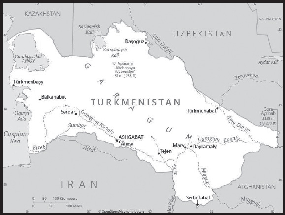
INTRODUCTION
Background: Present-day Turkmenistan covers territory that has been at the crossroads of civilizations for centuries. The area was ruled in antiquity by various Persian empires, and was conquered by Alexander the Great, Muslim armies, the Mongols, Turkic warriors, and eventually the Russians. In medieval times, Merv (located in present-day Mary province) was one of the great cities of the Islamic world and an important stop on the Silk Road. Annexed by Russia in the late 1800s, Turkmen territories later figured prominently in the anti-Bolshevik resistance in Central Asia. In 1924, Turkmenistan became a Soviet republic; it achieved independence upon the dissolution of the USSR in 1991. President for Life Saparmyrat NYYAZOW died in December 2006, and Gurbanguly BERDIMUHAMEDOW, a deputy chairman under NYYAZOW, emerged as the country’s new president. BERDIMUHAMEDOW won Turkmenistan’s first multi-candidate presidential election in February 2007, and again in 2012 and in 2017 with over 97% of the vote in both instances, in elections widely regarded as undemocratic. In February 2022, BERDIMUHAMEDOW announced that he would step down from the presidency and called for an election to replace him. His son, Serdar BERDIMUHAMEDOW, won the ensuing election, held in March 2022, with 73% of the vote. Gurbanguly BERDIMUHAMEDOW, although no longer head of state, maintains an influential political position as head of the Halk Maslahaty (People’s Council) and as National Leader of the Turkmen People, a title that provides additional privileges and immunity for him and his family. Since Gurbanguly BERDIMUHAMEDOW stepped down from the presidency, state-controlled media upgraded his honorific from Arkadag (protector) to Hero-Arkadag, and incorporated his son into the personality cult by referring to Serdar BERDIMUHAMEDOW as Arkadagly Serder, which can be translated as “Serder who has a protector to support him.”
Turkmenistan has sought new export markets for its extensive hydrocarbon/natural gas reserves, which have yet to be fully exploited. As of early 2022, Turkmenistan exported the majority of its gas to China and smaller levels of gas to Russia. Turkmenistan’s reliance on gas exports has made the economy vulnerable to fluctuations in the global energy market, and economic hardships since the drop in energy prices in 2014 have led many Turkmenistanis to emigrate, mostly to Turkey. Heavy restrictions placed by the government in 2020 on entry and exit into the country in response to the COVID-19 pandemic have resulted in a steep drop in emigration, however.
GEOGRAPHY
Location: Central Asia, bordering the Caspian Sea, between Iran and Kazakhstan
Geographic coordinates: 40 00 N, 60 00 E
Map references: Asia
Area: total: 488,100 sq km
land: 469,930 sq km
water: 18,170 sq km
comparison ranking: total 55
Area - comparative: slightly more than three times the size of Georgia; slightly larger than California
Land boundaries: total: 4,158 km
border countries (4): Afghanistan 804 km; Iran 1,148 km; Kazakhstan 413 km; Uzbekistan 1,793 km
Coastline: 0 km (landlocked); note - Turkmenistan borders the Caspian Sea (1,768 km)
Maritime claims: none (landlocked)
Climate: subtropical desert
Terrain: flat-to-rolling sandy desert with dunes rising to mountains in the south; low mountains along border with Iran; borders Caspian Sea in west
Elevation: highest point: Gora Ayribaba 3,139 m
lowest point: Vpadina Akchanaya (Sarygamysh Koli is a lake in northern Turkmenistan with a water level that fluctuates above and below the elevation of Vpadina Akchanaya, the lake has dropped as low as -110 m) -81 m
mean elevation: 230 m
Natural resources: petroleum, natural gas, sulfur, salt
Land use: agricultural land: 72% (2018 est.)
arable land: 4.1% (2018 est.)
permanent crops: 0.1% (2018 est.)
permanent pasture: 67.8% (2018 est.)
forest: 8.8% (2018 est.)
other: 19.2% (2018 est.)
Irrigated land: 19,950 sq km (2012)
Major lakes (area sq km): salt water lake(s): Caspian Sea (shared with Iran, Azerbaijan, Russia, and Kazakhstan) - 374,000 sq km
Major rivers (by length in km): Amu Darya (shared with Tajikistan [s], Afghanistan, and Uzbekistan [m]) - 2,620 km
note – [s] after country name indicates river source; [m] after country name indicates river mouth
Major watersheds (area sq km): Internal (endorheic basin) drainage: (Aral Sea basin) Amu Darya (534,739 sq km)
Population distribution: the most densely populated areas are the southern, eastern, and northeastern oases; approximately 50% of the population lives in and around the capital of Ashgabat
Natural hazards: earthquakes; mudslides; droughts; dust storms; floods
Geography - note: landlocked; the western and central low-lying desolate portions of the country make up the great Garagum (Kara-Kum) desert, which occupies over 80% of the country; eastern part is plateau
PEOPLE AND SOCIETY
Population: 5,690,818 (2023 est.)
note: some sources suggest Turkmenistan’s population could be as much as 1 to 2 million people lower than available estimates because of large-scale emigration during the last 10 years
comparison ranking: 115
Nationality: noun: Turkmenistani(s)
adjective: Turkmenistani
Ethnic groups: Turkmen 85%, Uzbek 5%, Russian 4%, other 6% (2003 est.)
Languages: Turkmen (official) 72%, Russian 12%, Uzbek 9%, other 7%
major-language sample(s): Dünýä Faktlar Kitaby – esasy maglumatlaryň wajyp çeşmesidir (Turkmen)
Religions: Muslim 93%, Christian 6.4%, Buddhist <1%, folk religion <1%, Jewish <1%, other <1%, unspecified <1% (2020 est.)
Demographic profile: While Turkmenistan reputedly has a population of more than 5.6 million, the figure is most likely considerably less. Getting an accurate population estimate for the country is impossible because then President Gurbanguly BERDIMUHAMEDOW withheld the results of the last two censuses. The 2012 census results reportedly show that nearly 2 million citizens have emigrated in the last decade, which prompted BERDIMUHAMEDOW to order another census. Results of this census, covering 2008-2018, also were not released to the public but purportedly are similar. Another census was held in December 2022.
Authorities have reacted to the dramatic population decline by preventing Turkmen from leaving the country, including removing citizens from international flights and refusing to provide necessary documents. Turkmenistan’s rise in outmigration – mainly to Turkey, Russia, and Uzbekistan – coincided with the country’s 2013-2014 economic crisis. The outflow has been sustained by poor living standards, inflation, low income, and a lack of health care. At the same time, Ashbagat is encouraging people to have more children to make up for its shrinking population.
Age structure: 0-14 years: 24.63% (male 710,040/female 691,487)
15-64 years: 68.82% (male 1,943,930/female 1,972,723)
65 years and over: 6.55% (2023 est.) (male 163,121/female 209,517)
Dependency ratios: total dependency ratio: 56.6
youth dependency ratio: 48.9
elderly dependency ratio: 7.7
potential support ratio: 13 (2021 est.)
Median age: total: 30.7 years (2023 est.)
male: 30.2 years
female: 31.2 years
comparison ranking: total 127
Population growth rate: 0.95% (2023 est.)
comparison ranking: 101
Birth rate: 17.2 births/1,000 population (2023 est.)
comparison ranking: 92
Death rate: 6 deaths/1,000 population (2023 est.)
comparison ranking: 157
Net migration rate: -1.7 migrant(s)/1,000 population (2023 est.)
comparison ranking: 165
Population distribution: the most densely populated areas are the southern, eastern, and northeastern oases; approximately 50% of the population lives in and around the capital of Ashgabat
Urbanization: urban population: 54% of total population (2023)
rate of urbanization: 2.23% annual rate of change (2020-25 est.)
Major urban areas - population: 902,000 ASHGABAT (capital) (2023)
Sex ratio: at birth: 1.05 male(s)/female
0-14 years: 1.03 male(s)/female
15-64 years: 0.99 male(s)/female
65 years and over: 0.78 male(s)/female
total population: 0.98 male(s)/female (2023 est.)
Mother’s mean age at first birth: 24.2 years (2019)
Maternal mortality ratio: 5 deaths/100,000 live births (2020 est.)
comparison ranking: 162
Infant mortality rate: total: 36.7 deaths/1,000 live births (2023 est.)
male: 44.7 deaths/1,000 live births
female: 28.4 deaths/1,000 live births
comparison ranking: total 35
Life expectancy at birth: total population: 72.1 years (2023 est.)
male: 69.1 years
female: 75.3 years
comparison ranking: total population 161
Total fertility rate: 2.03 children born/woman (2023 est.)
comparison ranking: 105
Gross reproduction rate: 0.99 (2023 est.)
Contraceptive prevalence rate: 49.7% (2019)
Drinking water source: improved: urban: 100% of population
rural: 100% of population
total: 100% of population
Current health expenditure: 5.7% of GDP (2020)
Physicians density: 2.23 physicians/1,000 population (2014)
Hospital bed density: 4 beds/1,000 population (2014)
Sanitation facility access: improved: urban: 99.8% of population
rural: 99.9% of population
total: 99.8% of population
unimproved: urban: 0.2% of population
rural: 0.1% of population
total: 0.2% of population (2020 est.)
Obesity - adult prevalence rate: 18.6% (2016)
comparison ranking: 116
Alcohol consumption per capita: total: 2.88 liters of pure alcohol (2019 est.)
beer: 0.65 liters of pure alcohol (2019 est.)
wine: 1.25 liters of pure alcohol (2019 est.)
spirits: 0.98 liters of pure alcohol (2019 est.)
other alcohols: 0 liters of pure alcohol (2019 est.)
comparison ranking: total 117
Tobacco use: total: 5.5% (2020 est.)
male: 10.6% (2020 est.)
female: 0.4% (2020 est.)
comparison ranking: total 160
Children under the age of 5 years underweight: 3.1% (2019)
comparison ranking: 88
Currently married women (ages 15-49): 64.3% (2023 est.)
Child marriage: women married by age 15: 0.2%
women married by age 18: 6.1% (2019 est.)
Education expenditures: 3.1% of GDP (2019 est.)
comparison ranking: 153
Literacy: definition: age 15 and over can read and write
total population: 99.7%
male: 99.8%
female: 99.6% (2015)
School life expectancy (primary to tertiary education): total: 13 years
male: 13 years
female: 13 years (2020)
Youth unemployment rate (ages 15-24): total: 11% (2021 est.)
male: 13.4%
female: 7.6%
comparison ranking: total 146
ENVIRONMENT
Environment - current issues: contamination of soil and groundwater with agricultural chemicals, pesticides; salination, water logging of soil due to poor irrigation methods; Caspian Sea pollution; diversion of a large share of the flow of the Amu Darya into irrigation contributes to that river’s inability to replenish the Aral Sea; soil erosion; desertification
Environment - international agreements: party to: Biodiversity, Climate Change, Climate Change-Kyoto Protocol, Climate Change-Paris Agreement, Comprehensive Nuclear Test Ban, Desertification, Hazardous Wastes, Ozone Layer Protection, Ship Pollution, Wetlands
signed, but not ratified: none of the selected agreements
Climate: subtropical desert
Land use: agricultural land: 72% (2018 est.)
arable land: 4.1% (2018 est.)
permanent crops: 0.1% (2018 est.)
permanent pasture: 67.8% (2018 est.)
forest: 8.8% (2018 est.)
other: 19.2% (2018 est.)
Urbanization: urban population: 54% of total population (2023)
rate of urbanization: 2.23% annual rate of change (2020-25 est.)
Revenue from forest resources: 0% of GDP (2018 est.)
comparison ranking: 180
Revenue from coal: 0% of GDP (2018 est.)
comparison ranking: 67
Air pollutants: particulate matter emissions: 26.41 micrograms per cubic meter (2019 est.)
carbon dioxide emissions: 70.63 megatons (2016 est.)
methane emissions: 52.09 megatons (2020 est.)
Waste and recycling: municipal solid waste generated annually: 500,000 tons (2013 est.)
Major lakes (area sq km): salt water lake(s): Caspian Sea (shared with Iran, Azerbaijan, Russia, and Kazakhstan) - 374,000 sq km
Major rivers (by length in km): Amu Darya (shared with Tajikistan [s], Afghanistan, and Uzbekistan [m]) - 2,620 km
note – [s] after country name indicates river source; [m] after country name indicates river mouth
Major watersheds (area sq km): Internal (endorheic basin) drainage: (Aral Sea basin) Amu Darya (534,739 sq km)
Total water withdrawal: municipal: 450 million cubic meters (2020 est.)
industrial: 810 million cubic meters (2020 est.)
agricultural: 16.12 billion cubic meters (2020 est.)
Total renewable water resources: 24.77 billion cubic meters (2020 est.)
GOVERNMENT
Country name: conventional long form: none
conventional short form: Turkmenistan
local long form: none
local short form: Turkmenistan
former: Turkmen Soviet Socialist Republic
etymology: the suffix “-stan” means “place of” or “country,” so Turkmenistan literally means the “Land of the Turkmen [people]”
Government type: presidential republic; authoritarian
Capital: name: Ashgabat (Ashkhabad)
geographic coordinates: 37 57 N, 58 23 E
time difference: UTC+5 (10 hours ahead of Washington, DC, during Standard Time)
etymology: derived from the Persian words eshq meaning “love” and abad meaning “inhabited place” or “city,” and so loosely translates as “the city of love”
Administrative divisions: 5 provinces (welayatlar, singular - welayat) and 1 independent city*: Ahal Welayaty (Anew), Ashgabat*, Balkan Welayaty (Balkanabat), Dasoguz Welayaty, Lebap Welayaty (Turkmenabat), Mary Welayaty
note: administrative divisions have the same names as their administrative centers (exceptions have the administrative center name following in parentheses)
Independence: 27 October 1991 (from the Soviet Union)
National holiday: Independence Day, 27 October (1991)
Constitution: history: several previous; latest adopted 14 September 2016
amendments: proposed by the Assembly or Mejlis; passage requires two-thirds majority vote or absolute majority approval in a referendum; amended several times, last in 2023 (changed legislature from bicameral to unicameral Assembly or Mejlis; reestablished People’s Council or Halk Maslahaty and named former president Gurbanguly BERDIMUHAMEDOW as National Leader of the Turkmen people
Legal system: civil law system with Islamic (sharia) law influences
International law organization participation: has not submitted an ICJ jurisdiction declaration; non-party state to the ICCt
Citizenship: citizenship by birth: no
citizenship by descent only: at least one parent must be a citizen of Turkmenistan
dual citizenship recognized: yes
residency requirement for naturalization: 7 years
Suffrage: 18 years of age; universal
Executive branch: chief of state: President Serdar BERDIMUHAMEDOW (since 19 March 2022); note - the president is both chief of state and head of government
head of government: President Serdar BERDIMUHAMEDOW (since 19 March 2022)
cabinet: Cabinet of Ministers appointed by the president
elections/appointments: president directly elected by absolute majority popular vote in 2 rounds if needed for a 7-year term (no term limits); election last held on 12 March 2022 (next to be held in 2029); note - on 11 February 2022, President Gurbanguly BERDIMUHAMEDOW announced his intent to retire setting up the early presidential election
election results: 2022: Serdar BERDIMUHAMEDOW elected president; percent of vote - Serdar BERDIMUHAMEDOW 73%, Khydyr NUNNAYEV 11.1%, Agadzhan BEKMYRADOV 7.2%, other 8.7%; note - Serdar BERDIMUHAMEDOW is the son of previous president Gurbanguly BERDIMUHAMEDOW
2017: Gurbanguly BERDIMUHAMEDOW reelected president in the first round; percent of vote - Gurbanguly BERDIMUHAMEDOW (DPT) 97.7%, other 2.3%
Legislative branch: description: unicameral Assembly or Mejlis (125 seats; members directly elected in single-seat constituencies by absolute majority vote in 2 rounds if needed to serve 5-year terms); formerly the Assembly was the lower house of the bicameral National Council or Milli Genes, which consisted of an upper house, the People’s Council or Halk Maslahaty, and the Assembly or Mejlis
elections: Mejlis (Assembly) - last held on 26 March 2023 for the Mejlis and local councils (next to be held in 2028)
election results: percent of vote by party - NA; seats by party - DPT 55, APT 11, PIE 11, independent 48 (individuals nominated by citizen groups); composition as of early as of April 2023 men 93, women 32, percent of women 25.6%
note: on 22 January 2023, a joint session of the then bicameral National Council or Milli Genes voted unanimously to abolish itself, re-establishing a unicameral legislature and a separate People’s Council or Halk Maslahaty
Judicial branch: highest court(s): Supreme Court of Turkmenistan (consists of the court president and 21 associate judges and organized into civil, criminal, and military chambers)
judge selection and term of office: judges appointed by the president for 5-year terms
subordinate courts: High Commercial Court; appellate courts; provincial, district, and city courts; military courts
Political parties and leaders: Agrarian Party of Turkmenistan or APT [Basim ANNAGURBANOW]
Democratic Party of Turkmenistan or DPT [Ata SERDAROW]
Party of Industrialists and Entrepreneurs or PIE [Saparmyrat OWGANOW]
note: all of these parties support President BERDIMUHAMEDOW; a law authorizing the registration of political parties went into effect in January 2012; unofficial, small opposition movements exist abroad
International organization participation: ADB, CIS (associate member, has not ratified the 1993 CIS charter although it participates in meetings and held the chairmanship of the CIS in 2012), EAPC, EBRD, ECO, FAO, G-77, IBRD, ICAO, ICRM, IDA, IDB, IFC, IFRCS, ILO, IMF, IMO, Interpol, IOC, IOM (observer), ISO (correspondent), ITU, MIGA, NAM, OIC, OPCW, OSCE, PFP, UN, UNCTAD, UNESCO, UNHCR, UNIDO, UNWTO, UPU, WCO, WFTU (NGOs), WHO, WIPO, WMO
Diplomatic representation in the US: chief of mission: Ambassador Meret ORAZOV (since 14 February 2001)
chancery: 2207 Massachusetts Avenue NW, Washington, DC 20008
telephone: [1] (202) 588-1500
FAX: [1] (202) 588-1500
email address and website: turkmenembassyus@verizon.net
https://usa.tmembassy.gov.tm/en
Diplomatic representation from the US: chief of mission: Ambassador Matthew S. KLIMOW (since 26 June 2019)
embassy: 9 1984 Street (formerly Pushkin Street), Ashgabat 744000
mailing address: 7070 Ashgabat Place, Washington, DC 20521-7070
telephone: [993] (12) 94-00-45
FAX: [993] (12) 94-26-14
email address and website: ConsularAshgab@state.gov
Flag description: green field with a vertical red stripe near the hoist side, containing five tribal guls (designs used in producing carpets) stacked above two crossed olive branches; five white, five-pointed stars and a white crescent moon appear in the upper corner of the field just to the fly side of the red stripe; the green color and crescent moon represent Islam; the five stars symbolize the regions or welayats of Turkmenistan; the guls reflect the national identity of Turkmenistan where carpetmaking has long been a part of traditional nomadic life
note: the flag of Turkmenistan is the most intricate of all national flags
National symbol(s): Akhal-Teke horse; national colors: green, white
National anthem: name: “Garassyz, Bitarap Turkmenistanyn” (Independent, Neutral, Turkmenistan State Anthem)
lyrics/music: collective/Veli MUKHATOV
note: adopted 1997, lyrics revised in 2008, to eliminate references to deceased President Saparmurat NYYAZOW
National heritage: total World Heritage Sites: 4 (all cultural)
selected World Heritage Site locales: Ancient Merv; Kunya-Urgench; Parthian Fortresses of Nisa; Silk Roads: Zarafshan-Karakum Corridor
ECONOMY
Economic overview: upper middle-income Central Asian economy; has 10% of global natural gas reserves, exporting to Russia and China; natural resource rich; authoritarian and dominated by state-owned enterprises; major central-south Asian pipeline development
Real GDP (purchasing power parity): $92.331 billion (2019 est.)
$86.859 billion (2018 est.)
$81.788 billion (2017 est.)
note: data are in 2017 dollars
comparison ranking: 95
Real GDP growth rate: 6.3% (2019 est.)
6.2% (2018 est.)
6.5% (2017 est.)
comparison ranking: 68
Real GDP per capita: $15,000 (2019 est.) note: data are in 2017 dollars
$14,300 (2018 est.) note: data are in 2017 dollars
$13,700 (2017 est.)
comparison ranking: 107
GDP (official exchange rate): $40.819 billion (2018 est.)
Inflation rate (consumer prices): 8% (2017 est.)
3.6% (2016 est.)
comparison ranking: 36
GDP - composition, by sector of origin: agriculture: 7.5% (2017 est.)
industry: 44.9% (2017 est.)
services: 47.7% (2017 est.)
comparison rankings: services 189; industry 18; agriculture 105
GDP - composition, by end use: household consumption: 50% (2017 est.)
government consumption: 10% (2017 est.)
investment in fixed capital: 28.2% (2017 est.)
investment in inventories: 0% (2017 est.)
exports of goods and services: 26.2% (2017 est.)
imports of goods and services: -14.3% (2017 est.)
Agricultural products: milk, wheat, cotton, tomatoes, potatoes, watermelons, grapes, sugar beets, beef, rice
Industries: natural gas, oil, petroleum products, textiles, food processing
Industrial production growth rate: 1% (2017 est.)
comparison ranking: 150
Labor force: 1.998 million (2021 est.)
comparison ranking: 125
Labor force - by occupation: agriculture: 48.2%
industry: 14%
services: 37.8% (2004 est.)
Unemployment rate: 5.08% (2021 est.)
4.95% (2020 est.)
4.27% (2019 est.)
comparison ranking: 148
Youth unemployment rate (ages 15-24): total: 11% (2021 est.)
male: 13.4%
female: 7.6%
comparison ranking: total 146
Population below poverty line: 0.2% (2012 est.)
Gini Index coefficient - distribution of family income: 40.8 (1998 est.)
comparison ranking: 52
Average household expenditures: on food: 37.5% of household expenditures (2018 est.)
on alcohol and tobacco: 2.2% of household expenditures (2018 est.)
Household income or consumption by percentage share: lowest 10%: 2.6%
highest 10%: 31.7% (1998)
Budget: revenues: $5.954 billion (2019 est.)
expenditures: $6.134 billion (2019 est.)
Budget surplus (+) or deficit (-): -2.8% (of GDP) (2017 est.)
comparison ranking: 123
Public debt: 28.8% of GDP (2017 est.)
24.1% of GDP (2016 est.)
comparison ranking: 172
Taxes and other revenues: 14.9% (of GDP) (2017 est.)
comparison ranking: 147
Fiscal year: calendar year
Current account balance: -$4.359 billion (2017 est.)
-$7.207 billion (2016 est.)
comparison ranking: 182
Exports: $7.458 billion (2017 est.)
$6.987 billion (2016 est.)
comparison ranking: 118
Exports - partners: China 82% (2019)
Exports - commodities: natural gas, refined petroleum, crude petroleum, cotton fibers, fertilizers (2019)
Imports: $4.571 billion (2017 est.)
$5.215 billion (2016 est.)
comparison ranking: 147
Imports - partners: Turkey 25%, Russia 18%, China 14%, Germany 6% (2019)
Imports - commodities: iron products, harvesting machinery, packaged medicines, broadcasting equipment, tractors (2019)
Reserves of foreign exchange and gold: $24.91 billion (31 December 2017 est.)
$25.05 billion (31 December 2016 est.)
comparison ranking: 63
Debt - external: $539.4 million (31 December 2017 est.)
$425.3 million (31 December 2016 est.)
comparison ranking: 177
Exchange rates: Turkmenistani manat (TMM) per US dollar -
Exchange rates: 4.125 (2017 est.)
3.5 (2016 est.)
3.5 (2015 est.)
3.5 (2014 est.)
2.85 (2013 est.)
ENERGY
Electricity access: electrification - total population: 100% (2021)
Electricity: installed generating capacity: 5.205 million kW (2020 est.)
consumption: 15.09 billion kWh (2019 est.)
exports: 3.2 billion kWh (2019 est.)
imports: 0 kWh (2019 est.)
transmission/distribution losses: 2.892 billion kWh (2019 est.)
comparison rankings: installed generating capacity 86; transmission/distribution losses 67; imports 128; exports 42; consumption 81
Electricity generation sources: fossil fuels: 100% of total installed capacity (2020 est.)
Petroleum: total petroleum production: 235,300 bbl/day (2021 est.)
refined petroleum consumption: 153,400 bbl/day (2019 est.)
crude oil and lease condensate exports: 59,900 bbl/day (2018 est.)
crude oil and lease condensate imports: 0 bbl/day (2018 est.)
crude oil estimated reserves: 600 million barrels (2021 est.)
Refined petroleum products - production: 191,100 bbl/day (2015 est.)
comparison ranking: 52
Refined petroleum products - exports: 53,780 bbl/day (2015 est.)
comparison ranking: 53
Refined petroleum products - imports: 0 bbl/day (2015 est.)
comparison ranking: 213
Natural gas: production: 83.623 billion cubic meters (2019 est.)
consumption: 45.399 billion cubic meters (2019 est.)
exports: 38.224 billion cubic meters (2019 est.)
imports: 0 cubic meters (2021 est.)
proven reserves: 11.327 trillion cubic meters (2021 est.)
Carbon dioxide emissions: 109.037 million metric tonnes of CO2 (2019 est.)
from petroleum and other liquids: 19.977 million metric tonnes of CO2 (2019 est.)
from consumed natural gas: 89.06 million metric tonnes of CO2 (2019 est.)
comparison ranking: total emissions 39
Energy consumption per capita: 330.507 million Btu/person (2019 est.)
comparison ranking: 9
COMMUNICATIONS
Telephones - fixed lines: total subscriptions: 800,000 (2021 est.)
subscriptions per 100 inhabitants: 13 (2021 est.)
comparison ranking: total subscriptions 75
Telephones - mobile cellular: total subscriptions: 6.3 million (2021 est.)
subscriptions per 100 inhabitants: 99 (2021 est.)
comparison ranking: total subscriptions 113
Telecommunication systems: general assessment: the nation of Turkmenistan, which rivals only North Korea for its isolationism, continues to keep its telecom sector along with the broader populace under tight control; the country inched up just one point off the bottom of the world rankings for press and internet freedom in the most recent report from Reporters Without Borders; most social networks in the country are blocked, although locals do have access to the government-developed platform released in 2019; all internet users, however, need to identify themselves before logging on, and strict censorship over what can be viewed is in force; the end result is that Turkmenistan has one of the lowest penetration rates for internet access in the world (2022)
domestic: fixed-line is 13 per 100 and mobile-cellular teledensity is 99 per 100 persons (2021)
international: country code - 993; linked by fiber-optic cable and microwave radio relay to other CIS republics and to other countries by leased connections to the Moscow international gateway switch; an exchange in Ashgabat switches international traffic through Turkey via Intelsat; satellite earth stations - 1 Orbita and 1 Intelsat (2018)
Broadcast media: broadcast media is government controlled and censored; 7 state-owned TV and 4 state-owned radio networks; satellite dishes and programming provide an alternative to the state-run media; officials sometimes limit access to satellite TV by removing satellite dishes
Internet country code: .tm
Internet users: total: 1,563,023 (2022 est.)
percent of population: 25.3% (2022 est.)
comparison ranking: total 143
Broadband - fixed subscriptions: total: 10,000 (2020 est.)
subscriptions per 100 inhabitants: 0.2 (2020 est.)
comparison ranking: total 180
TRANSPORTATION
National air transport system: number of registered air carriers: 1 (2020)
inventory of registered aircraft operated by air carriers: 27
annual passenger traffic on registered air carriers: 2,457,474 (2018)
annual freight traffic on registered air carriers: 16.92 million (2018) mt-km
Civil aircraft registration country code prefix: EZ
Airports: 26 (2021)
comparison ranking: total 125
Airports - with paved runways: 21
note: paved runways have a concrete or asphalt surface but not all have facilities for refueling, maintenance, or air traffic control; the length of a runway required for aircraft to safely operate depends on a number of factors including the type of aircraft, the takeoff weight (including passengers, cargo, and fuel), engine types, flap settings, landing speed, elevation of the airport, and average maximum daily air temperature; paved runways can reach a length of 5,000 m (16,000 ft.), but the “typical” length of a commercial airline runway is between 2,500-4,000 m (8,000-13,000 ft.)
Airports - with unpaved runways: 5
note: unpaved runways have a surface composition such as grass or packed earth and are most suited to the operation of light aircraft; unpaved runways are usually short, often less than 1,000 m (3,280 ft.) in length; airports with unpaved runways often lack facilities for refueling, maintenance, or air traffic control
Heliports: 1 (2021)
Pipelines: 7,500 km gas, 1501 km oil (2013)
Railways: total: 5,113 km (2017)
broad gauge: 5,113 km (2017) 1.520-m gauge
comparison ranking: total 37
Roadways: total: 58,592 km (2002)
paved: 47,577 km (2002)
unpaved: 11,015 km (2002)
comparison ranking: total 77
Waterways: 1,300 km (2011) (Amu Darya River and Kara Kum Canal are important inland waterways)
comparison ranking: 59
Merchant marine: total: 72 (2022)
by type: general cargo 6, oil tanker 8, other 58
comparison ranking: total 105
Ports and terminals: major seaport(s): Caspian Sea - Turkmenbasy
MILITARY AND SECURITY
Military and security forces: Armed Forces of Turkmenistan (aka Turkmen National Army): Land Forces, Navy, Air and Air Defense Forces
Ministry of Internal Affairs: Internal Troops, national police, Federal/State Border Guard Service (2023)
Military expenditures: 1.9% of GDP (2019 est.)
1.8% of GDP (2018 est.)
1.8% of GDP (2017 est.)
1.8% of GDP (2016 est.)
1.5% of GDP (2015 est.)
comparison ranking: 66
Military and security service personnel strengths: information varies; estimated 35,000 active-duty troops (30,000 Army; 1,000 Navy; 4,000 Air and Air Defense Forces) (2023)
Military equipment inventories and acquisitions: the inventory for Turkmenistan’s military is comprised largely of older Russian and Soviet-era weapons systems; in recent years however, it has attempted to diversify and purchased equipment from more than a dozen countries, with China, Italy, and Turkey as the top suppliers (2023)
Military service age and obligation: 18-27 years of age for compulsory military service for men; 24-month conscript service obligation (30 months for the Navy); 20 years of age for voluntary service for men and women; men may enroll in military schools from age 15 (2023)
Military - note: the military is responsible for external defense and works closely with the Border Service on protecting the country’s borders; it is conscript-based and equipped with Soviet-era arms; while Turkmenistan has a policy of permanent and “positive” neutrality and has declined to participate in post-Soviet military groupings such as the Collective Security Treaty Organization and the Shanghai Cooperation Organization, it has participated in multinational exercises and bilateral training with neighboring countries, including Russia and Uzbekistan; Turkmenistan joined NATO’s Partnership for Peace program in 1994, but it does not offer any military forces to NATO-led operations information on the structure of the military is limited and varied; the primary Land Force combat units are reportedly up to 4 “motorized rifle” divisions (MRD) inherited from the former Soviet Army after the USSR’s collapse in 1991; MRDs are typically comprised of one or more mechanized infantry regiments, plus a tank and an artillery regiment; there are reportedly also some separate motorized rifle (mechanized infantry), artillery, and surface-to-surface missile brigades; in recent years, Turkmenistan has made efforts to strengthen its naval capabilities on the Caspian Sea, including expanding ship building capabilities and adding larger vessels to the Navy’s inventory; in 2018, Turkmenistan opened its first naval shipyard, and in 2021 the Navy commissioned its largest warship, a corvette that was jointly constructed with Turkey, to complement a small existing force of coastal patrol craft; the Border Service also has a force of patrol boats; the Air Force has approximately 50 operational Soviet-era fighter and ground attack aircraft, as well as a few combat helicopters (2023)
SPACE
Space agency/agencies: Turkmenistan National Space Agency (established 2011; in 2019, was transferred to the Space Directorate of Turkmenaragatnashik Agency) (2023)
Space program overview: has a small space program focused on acquiring satellites and developing the infrastructure to build and operate satellites; particularly interested in remote sensing satellites for such purposes as monitoring its agricultural and transportation sectors, the oil and natural gas industry, and the ecology of the Caspian Sea; has cooperated with the space agencies and/or space industries of France, Italy, Russia, and the US (2023)
note: further details about the key activities, programs, and milestones of the country’s space program, as well as government spending estimates on the space sector, appear in Appendix S
TRANSNATIONAL ISSUES
Disputes - international: Turkmenistan-Azerbaijan: in January 2021, the two countries reached a preliminary agreement on the joint exploration of an undersea hydrocarbon field containing oil and natural gas in the Caspian Sea
Turkmenistan-Iran: none identified
Turkmenistan-Kazakhstan: Kazakhstan and Turkmenistan signed a treaty on the delimitation and demarcation process in 2001; field demarcation of the boundaries with Kazakhstan commenced in 2005; Turkmenistan and Kazakhstan agreed to their border in the Caspian Sea in 2014
Turkmenistan-Kazakhstan-Uzbekistan: in 2017, the three countries signed an agreement of the junction of their borders
Turkmenistan-Uzbekistan: cotton monoculture in Uzbekistan and Turkmenistan creates water-sharing difficulties for Amu Darya river states; in 2021, the two countries reached an agreement to create a joint intergovernmental commission to oversee water management
Refugees and internally displaced persons: stateless persons: 4,463 (2022)
Trafficking in persons: tier rating: Tier 3 — Turkmenistan does not fully meet the minimum standards for the elimination of trafficking and is not making significant efforts to do so, therefore, Turkmenistan remained on Tier 3; the government took some steps to address trafficking, including participating in anti-trafficking awareness campaigns; however, there was a government policy or pattern of forced labor, including mobilization of adults and children for forced labor in annual harvest, public works, and other sectors; officials denied access to independent monitors seeking to observe the cotton harvest; the government did not report any investigations, prosecutions, or convictions, nor hold any officials accountable for complicity in forced labor crimes; authorities did not identify victims nor fund victim assistance programs (2022)
trafficking profile: human traffickers exploit domestic victims in Turkmenistan, and Turkmen men and women are exploited abroad; state policies continue to perpetuate government-compelled forced labor in the cotton sector, as well as in public works and community cleaning and beautification projects; officials reportedly force the homeless into agricultural work or domestic servitude in the homes of law enforcement families; children are reportedly forced to work in cotton and potato fields during summer educational camps; residents of rural areas are at highest risk for trafficking both in country and abroad; LGBTQI+ communities are vulnerable to police abuse, extortion, and coercion, as well as sex trafficking or forced labor; Turkmen men and women are subjected to forced labor after migrating abroad; some migrant men are forced into criminal drug trafficking, and some migrant women are exploited by sex traffickers; most Turkmen migrant victims are in Turkey, Russia, and India, as well as other countries in the Middle East, South and Central Asia, and Europe (2022)
Illicit drugs: transit country for Afghan opiates to Turkish, Russian, and European markets, either directly from Afghanistan or through Iran; not a major producer or source country for illegal drugs or precursor chemicals
TURKS AND CAICOS ISLANDS
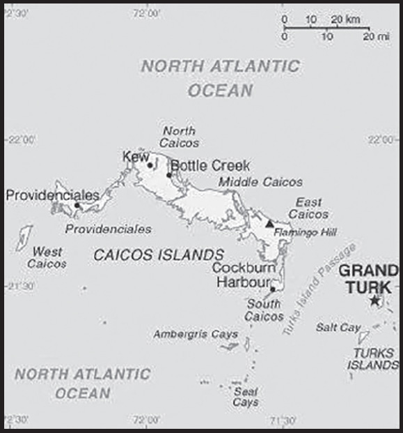
INTRODUCTION
Background: The islands were part of the UK’s Jamaican colony until 1962, when they assumed the status of a separate Crown colony upon Jamaica’s independence. The governor of The Bahamas oversaw affairs from 1965 to 1973. With Bahamian independence, the islands received a separate governor in 1973. Although independence was agreed upon for 1982, the policy was reversed and the islands remain a British overseas territory. Grand Turk island suffered extensive damage from Hurricane Maria on 22 September 2017 resulting in loss of power and communications, as well as damage to housing and businesses.
GEOGRAPHY
Location: two island groups in the North Atlantic Ocean, southeast of The Bahamas, north of Haiti; note - although the Turks and Caicos Islands do not border the Caribbean Sea, geopolitically they are often designated as being Caribbean
Geographic coordinates: 21 45 N, 71 35 W
Map references: Central America and the Caribbean
Area: total: 948 sq km
land: 948 sq km
water: 0 sq km
comparison ranking: total 185
Area - comparative: 2.5 times the size of Washington, DC
Land boundaries: total: 0 km
Coastline: 389 km
Maritime claims: territorial sea: 12 nm
exclusive fishing zone: 200 nm
Climate: tropical; marine; moderated by trade winds; sunny and relatively dry
Terrain: low, flat limestone; extensive marshes and mangrove swamps
Elevation: highest point: Blue Hill on Providenciales and Flamingo Hill on East Caicos 48 m
lowest point: Caribbean Sea 0 m
Natural resources: spiny lobster, conch
Land use: agricultural land: 1.1% (2018 est.)
arable land: 1.1% (2018 est.)
permanent crops: 0% (2018 est.)
permanent pasture: 0% (2018 est.)
forest: 36.2% (2018 est.)
other: 62.7% (2018 est.)
Irrigated land: 0 sq km (2022)
Population distribution: eight of the thirty islands are inhabited; the island of Providenciales is the most populated, but the most densely populated is Grand Turk
Natural hazards: frequent hurricanes
Geography - note: include eight large islands and numerous smaller cays, islets, and reefs; only two of the Caicos Islands and six of the Turks group are inhabited
PEOPLE AND SOCIETY
Population: 59,367 (2023 est.)
comparison ranking: 205
Nationality: noun: none
adjective: none
Ethnic groups: Black 87.6%, White 7.9%, mixed 2.5%, East Indian 1.3%, other 0.7% (2006 est.)
Languages: English (official)
Religions: Protestant 72.8% (Baptist 35.8%, Church of God 11.7%, Anglican 10%, Methodist 9.3%, Seventh Day Adventist 6%), Roman Catholic 11.4%, Jehovah’s Witness 1.8%, other 14% (2006 est.)
Age structure: 0-14 years: 20.7% (male 6,262/female 6,026)
15-64 years: 73.24% (male 21,860/female 21,619)
65 years and over: 6.06% (2023 est.) (male 1,741/female 1,859)
Dependency ratios: total dependency ratio: 36.8
youth dependency ratio: 22.9
elderly dependency ratio: 13.9
potential support ratio: 7.2 (2021)
Median age: total: 35.9 years (2023 est.)
male: 36.1 years
female: 35.7 years
comparison ranking: total 88
Population growth rate: 1.81% (2023 est.)
comparison ranking: 50
Birth rate: 13.2 births/1,000 population (2023 est.)
comparison ranking: 132
Death rate: 3.5 deaths/1,000 population (2023 est.)
comparison ranking: 222
Net migration rate: 8.4 migrant(s)/1,000 population (2023 est.)
comparison ranking: 11
Population distribution: eight of the thirty islands are inhabited; the island of Providenciales is the most populated, but the most densely populated is Grand Turk
Urbanization: urban population: 94.2% of total population (2023)
rate of urbanization: 1.46% annual rate of change (2020-25 est.)
Major urban areas - population: 5,000 GRAND TURK (capital) (2018)
Sex ratio: at birth: 1.05 male(s)/female
0-14 years: 1.04 male(s)/female
15-64 years: 1.01 male(s)/female
65 years and over: 0.94 male(s)/female
total population: 1.01 male(s)/female (2023 est.)
Infant mortality rate: total: 11.3 deaths/1,000 live births (2023 est.)
male: 14.2 deaths/1,000 live births
female: 8.3 deaths/1,000 live births
comparison ranking: total 121
Life expectancy at birth: total population: 81 years (2023 est.)
male: 78.3 years
female: 83.9 years
comparison ranking: total population 44
Total fertility rate: 1.7 children born/woman (2023 est.)
comparison ranking: 164
Gross reproduction rate: 0.83 (2023 est.)
Contraceptive prevalence rate: 34.4% (2019/20)
Drinking water source: improved: total: 94.3% of population
unimproved: total: 5.7% of population (2017)
Sanitation facility access: improved: total: 88% of population
unimproved: total: 12% of population (2017)
Children under the age of 5 years underweight: 0.4% (2019/20)
comparison ranking: 123
Currently married women (ages 15-49): 59.1% (2023 est.)
Child marriage: women married by age 18: 23.3%
men married by age 18: 5.1% (2020 est.)
Education expenditures: 4.5% of GDP (2021 est.)
comparison ranking: 99
School life expectancy (primary to tertiary education): total: 9 years
People - note: destination and transit point for illegal Haitian immigrants bound for the Bahamas and the US
ENVIRONMENT
Environment - current issues: limited natural freshwater resources, private cisterns collect rainwater
Climate: tropical; marine; moderated by trade winds; sunny and relatively dry
Land use: agricultural land: 1.1% (2018 est.)
arable land: 1.1% (2018 est.)
permanent crops: 0% (2018 est.)
permanent pasture: 0% (2018 est.)
forest: 36.2% (2018 est.)
other: 62.7% (2018 est.)
Urbanization: urban population: 94.2% of total population (2023)
rate of urbanization: 1.46% annual rate of change (2020-25 est.)
Revenue from forest resources: 0% of GDP (2018 est.)
comparison ranking: 166
Revenue from coal: 0% of GDP (2018 est.)
comparison ranking: 186
Air pollutants: carbon dioxide emissions: 0.22 megatons (2016 est.)
GOVERNMENT
Country name: conventional long form: none
conventional short form: Turks and Caicos Islands
abbreviation: TCI
etymology: the Turks Islands are named after the Turk’s cap cactus (native to the islands and appearing on the flag and coat of arms), while the Caicos Islands derive from the native term “caya hico” meaning “string of islands”
Government type: parliamentary democracy
Dependency status: overseas territory of the UK
Capital: name: Grand Turk (Cockburn Town)
geographic coordinates: 21 28 N, 71 08 W
time difference: UTC-5 (same time as Washington, DC, during Standard Time)
etymology: named after Sir Francis COCKBURN, who served as governor of the Bahamas from 1837 to 1844
Administrative divisions: none (overseas territory of the UK)
Independence: none (overseas territory of the UK)
National holiday: Birthday of Queen ELIZABETH II, usually celebrated the Monday after the second Saturday in June
Constitution: history: several previous; latest signed 7 August 2012, effective 15 October 2012 (The Turks and Caicos Constitution Order 2011)
amendments: NA
Legal system: mixed legal system of English common law and civil law
Citizenship: see United Kingdom
Suffrage: 18 years of age; universal
Executive branch: chief of state: King CHARLES III (since 8 September 2022); represented by Governor Nigel DAKIN (since 15 July 2019)
head of government: Premier Washington MISICK (since 19 February 2021)
cabinet: Cabinet appointed by the governor from among members of the House of Assembly
elections/appointments: the monarch is hereditary; governor appointed by the monarch; following legislative elections, the leader of the majority party is appointed premier by the governor
Legislative branch: description: unicameral House of Assembly (21 seats; 15 members in multi-seat constituencies and a single all-islands constituency directly elected by simple majority vote, 1 member nominated by the premier and appointed by the governor, 1 nominated by the opposition party leader and appointed by the governor, and 2 from the Turks and Caicos Islands Civic Society directly appointed by the governor, and 2 ex-officio members; members serve 4-year terms)
elections: last held on 19 February 2021 (next to be held in 2025)
election results: percent of vote - NA; seats by party - PNP 14, PDM 1; composition as of mid-2022 (elected members) - men 12, women 3; percent of women 20%
Judicial branch: highest court(s): Supreme Court (consists of the chief justice and other judges, as determined by the governor); Court of Appeal (consists of the court president and 2 justices); note - appeals beyond the Supreme Court are referred to the Judicial Committee of the Privy Council (in London)
judge selection and term of office: Supreme Court and Appeals Court judges appointed by the governor in accordance with the Judicial Service Commission, a 3-member body of high-level judicial officials; Supreme Court judges serve until mandatory retirement at age 65, but terms can be extended to age 70; Appeals Court judge tenure determined by individual terms of appointment
subordinate courts: magistrates’ courts
Political parties and leaders: People’s Democratic Movement or PDM [Edwin ASTWOOD]
Progressive National Party or PNP [Washington MISICK]
International organization participation: Caricom (associate), CDB, Interpol (subbureau), UPU
Diplomatic representation in the US: none (overseas territory of the UK)
Diplomatic representation from the US: embassy: none (overseas territory of the UK)
Flag description: blue with the flag of the UK in the upper hoist-side quadrant and the colonial shield centered on the outer half of the flag; the shield is yellow and displays a conch shell, a spiny lobster, and Turk’s cap cactus - three common elements of the islands’ biota
National symbol(s): conch shell, Turk’s cap cactus
National anthem: name: “This Land of Ours”
lyrics/music: Conrad HOWELL
note: serves as a local anthem; as an overseas territory of the UK, “God Save the King” is the official anthem (see United Kingdom)
ECONOMY
Economic overview: British Caribbean island territorial economy; GDP and its tourism industry hit hard by COVID-19 disruptions; major biodiversity locale; US dollar user; fossil fuel dependent; negative trade balance; increasing unemployment
Real GDP (purchasing power parity): $835.171 million (2021 est.)
$817.993 million (2020 est.)
$1.117 billion (2019 est.)
note: data are in 2017 dollars
comparison ranking: 209
Real GDP growth rate: 2.1% (2021 est.)
-26.78% (2020 est.)
5.32% (2019 est.)
comparison ranking: 163
Real GDP per capita: $18,500 (2021 est.)
$18,500 (2020 est.)
$25,900 (2019 est.)
note: data are in 2017 dollars
comparison ranking: 99
GDP (official exchange rate): $1.02 billion (2018 est.)
Inflation rate (consumer prices): 4% (2017 est.)
0.7% (2016 est.)
comparison ranking: 95
GDP - composition, by sector of origin: agriculture: 0.5% (2017 est.)
industry: 8.9% (2017 est.)
services: 90.6% (2017 est.)
comparison rankings: services 8; industry 209; agriculture 209
GDP - composition, by end use: household consumption: 49% (2017 est.)
government consumption: 21.5% (2017 est.)
investment in fixed capital: 16.5% (2017 est.)
investment in inventories: -0.1% (2017 est.)
exports of goods and services: 69.5% (2017 est.)
imports of goods and services: -56.4% (2017 est.)
Agricultural products: corn, beans, cassava (manioc, tapioca), citrus fruits; fish
Industries: tourism, offshore financial services
Industrial production growth rate: 5% (2021 est.)
comparison ranking: 91
Labor force: 4,848 (1990 est.)
comparison ranking: 220
Labor force - by occupation: note: about 33% in government and 20% in agriculture and fishing; significant numbers in tourism, financial, and other services
Unemployment rate: 10% (1997 est.)
comparison ranking: 71
Budget: revenues: $247.3 million (2017 est.)
expenditures: $224.3 million (2017 est.)
Fiscal year: calendar year
Current account balance: $172.709 million (2018 est.)
$35.016 million (2017 est.)
$247.081 million (2016 est.)
comparison ranking: 64
Exports: $827 million (2018 est.) note: data are in current year dollars
$603 million (2017 est.)
comparison ranking: 181
Exports - partners: France 31%, United States 16%, Zambia 13%, Singapore 9%, Republic of the Congo 8% (2019)
Exports - commodities: plastic building materials, stone processing machinery, iron structures, crustaceans, integrated circuits (2019)
Imports: $544.219 million (2018 est.) note: data are in current year dollars
$484.842 million (2017 est.)
comparison ranking: 199
Imports - partners: United States 76% (2019)
Imports - commodities: refined petroleum, cars, jewelry, furniture, soybeans (2019)
Exchange rates: the US dollar is used
ENERGY
Electricity access: electrification - total population: 100% (2021)
Electricity: installed generating capacity: 85,000 kW (2020 est.)
consumption: 231.618 million kWh (2019 est.)
exports: 0 kWh (2020 est.)
imports: 0 kWh (2020 est.)
transmission/distribution losses: 12.5 million kWh (2019 est.)
comparison rankings: imports 131; exports 112; installed generating capacity 187; transmission/distribution losses 191; consumption 184
Electricity generation sources: fossil fuels: 100% of total installed capacity (2020 est.)
Petroleum: total petroleum production: 0 bbl/day (2021 est.)
refined petroleum consumption: 1,600 bbl/day (2019 est.)
Refined petroleum products - imports: 1,369 bbl/day (2015 est.)
comparison ranking: 196
Carbon dioxide emissions: 245,000 metric tonnes of CO2 (2019 est.)
from petroleum and other liquids: 245,000 metric tonnes of CO2 (2019 est.)
comparison ranking: total emissions 200
Energy consumption per capita: 0 Btu/person (2019 est.)
comparison ranking: 199
COMMUNICATIONS
Telephones - fixed lines: total subscriptions: 4,000 (2021 est.)
subscriptions per 100 inhabitants: 9 (2021 est.)
comparison ranking: total subscriptions 209
Telephones - mobile cellular: total subscriptions: 25,085 (2004 est.)
subscriptions per 100 inhabitants: 110 (2004 est.)
comparison ranking: total subscriptions 213
Telecommunication systems: general assessment: is connected to the internet via a single submarine fiber-optic cable (Arcos-1), which links the US and several Caribbean countries (2023)
domestic: fixed-line teledensity is 9 per 100 persons (2021)
international: country code - 1-649; landing point for the ARCOS fiber-optic telecommunications submarine cable providing connectivity to South and Central America, parts of the Caribbean, and the US; satellite earth station - 1 Intelsat (Atlantic Ocean) (2020)
Broadcast media: no local terrestrial TV stations, broadcasts from the Bahamas can be received and multi-channel cable and satellite TV services are available; government-run radio network operates alongside private broadcasters with a total of about 15 stations
Internet country code: .tc
Internet users: total: 37,008 (2022)
percent of population: 93.5% (2022)
comparison ranking: total 207
TRANSPORTATION
National air transport system: number of registered air carriers: 3 (2020)
inventory of registered aircraft operated by air carriers: 22
Civil aircraft registration country code prefix: VQ-T
Airports: 8 (2021)
comparison ranking: total 162
Airports - with paved runways: 6
note: paved runways have a concrete or asphalt surface but not all have facilities for refueling, maintenance, or air traffic control; the length of a runway required for aircraft to safely operate depends on a number of factors including the type of aircraft, the takeoff weight (including passengers, cargo, and fuel), engine types, flap settings, landing speed, elevation of the airport, and average maximum daily air temperature; paved runways can reach a length of 5,000 m (16,000 ft.), but the “typical” length of a commercial airline runway is between 2,500-4,000 m (8,000-13,000 ft.)
Airports - with unpaved runways: 2
note: unpaved runways have a surface composition such as grass or packed earth and are most suited to the operation of light aircraft; unpaved runways are usually short, often less than 1,000 m (3,280 ft.) in length; airports with unpaved runways often lack facilities for refueling, maintenance, or air traffic control
Roadways: total: 121 km (2003)
paved: 24 km (2003)
unpaved: 97 km (2003)
comparison ranking: total 212
Merchant marine: total: 3 (2022)
by type: general cargo 1, other 2
comparison ranking: total 174
Ports and terminals: major seaport(s): Cockburn Harbour, Grand Turk, Providenciales
MILITARY AND SECURITY
Military - note: defense is the responsibility of the UK
TRANSNATIONAL ISSUES
Disputes - international: none identified
Illicit drugs: transshipment point for South American narcotics destined for the US and Europe
TUVALU
INTRODUCTION
Background: The islands were first populated by voyagers from either Samoa or Tonga in the first millennium A.D., and Tuvalu provided a steppingstone for various Polynesian communities that subsequently settled in Melanesia and Micronesia. Tuvalu eventually came under Samoan and Tongan spheres of influence although proximity to Micronesia allowed some Micronesian communities to flourish in Tuvalu, in particular on Nui Atoll. In the late 1700s and early 1800s, Tuvalu was visited by a series of American, British, Dutch, and Russian ships. The islands were named the Ellice Islands in 1819. The first Christian missionaries arrived in 1861, eventually converting most of the population, and around the same time, several hundred Tuvaluans were kidnapped by people purporting to be missionaries and sent to work on plantations in Peru and Hawaii.
The UK declared a protectorate over the Ellice Islands in 1892 and merged it with the Micronesian Gilbert Islands. The Gilbert and Ellice Islands Protectorate became a colony in 1916. During World War II, the US set up military bases on a few islands, and in 1943, after Japan captured many of the northern Gilbert Islands, the UK transferred administration of the colony southward to Funafuti. After the war, Tarawa in the Gilbert Islands was once again made the colony’s capital and the center of power was firmly in the Gilbert Islands, including the colony’s only secondary school. Amid growing tensions with the Gilbertese, Tuvaluans voted to secede from the colony in 1974, were granted self-rule in 1975, and gained independence in 1978 as Tuvalu. In 1979, the US relinquished its claims to Tuvaluan islands in a treaty of friendship.
The Tuvalu Trust Fund was established in 1987 to provide a longterm economic future for the country. In 2000, Tuvalu negotiated a contract leasing its Internet domain name “.tv” for $50 million in royalties over a 12-year period. The contract was renewed in 2011 for a ten-year period. Tuvalu’s isolation means it sees few tourists; in 2020, Funafuti International Airport had four weekly flights - three to Suva, Fiji, and one to Tarawa. Tuvalu is highly vulnerable to the effects of climate change; in 2018, sea levels in Funafuti were rising twice as fast as global averages.
GEOGRAPHY
Location: Oceania, island group consisting of nine coral atolls in the South Pacific Ocean, about half way from Hawaii to Australia
Geographic coordinates: 8 00 S, 178 00 E
Map references: Oceania
Area: total: 26 sq km
land: 26 sq km
water: 0 sq km
comparison ranking: total 237
Area - comparative: 0.1 times the size of Washington, DC
Land boundaries: total: 0 km
Coastline: 24 km
Maritime claims: territorial sea: 12 nm
contiguous zone: 24 nm
exclusive economic zone: 200 nm
Climate: tropical; moderated by easterly trade winds (March to November); westerly gales and heavy rain (November to March)
Terrain: low-lying and narrow coral atolls
Elevation: highest point: unnamed location 5 m
lowest point: Pacific Ocean 0 m
mean elevation: 2 m
Natural resources: fish, coconut (copra)
Land use: agricultural land: 60% (2018 est.)
arable land: 0% (2018 est.)
permanent crops: 60% (2018 est.)
permanent pasture: 0% (2018 est.)
forest: 33.3% (2018 est.)
other: 6.7% (2018 est.)
Irrigated land: 0 sq km (2022)
Population distribution: over half of the population resides on the atoll of Funafuti
Natural hazards: severe tropical storms are usually rare, but in 1997 there were three cyclones; low levels of islands make them sensitive to changes in sea level
Geography - note: one of the smallest and most remote countries on Earth; six of the nine coral atolls - Nanumea, Nui, Vaitupu, Nukufetau, Funafuti, and Nukulaelae - have lagoons open to the ocean; Nanumaya and Niutao have landlocked lagoons; Niulakita does not have a lagoon
PEOPLE AND SOCIETY
Population: 11,639 (2023 est.)
comparison ranking: 221
Nationality: noun: Tuvaluan(s)
adjective: Tuvaluan
Ethnic groups: Tuvaluan 97%, Tuvaluan/I-Kiribati 1.6%, Tuvaluan/other 0.8%, other 0.6% (2017 est.)
Languages: Tuvaluan (official), English (official), Samoan, Kiribati (on the island of Nui)
Religions: Protestant 92.7% (Congregational Christian Church of Tuvalu 85.9%, Brethren 2.8%, Seventh Day Adventist 2.5%, Assemblies of God 1.5%), Baha’i 1.5%, Jehovah’s Witness 1.5%, other 3.9%, none or refused 0.4% (2017 est.)
Age structure: 0-14 years: 29.27% (male 1,745/female 1,662)
15-64 years: 63.3% (male 3,703/female 3,664)
65 years and over: 7.43% (2023 est.) (male 318/female 547)
Dependency ratios: total dependency ratio: 60.9
youth dependency ratio: 50.9
elderly dependency ratio: 10
potential support ratio: 10 (2021)
Median age: total: 27.5 years (2023 est.)
male: 26.5 years
female: 28.6 years
comparison ranking: total 153
Population growth rate: 0.81% (2023 est.)
comparison ranking: 113
Birth rate: 22.3 births/1,000 population (2023 est.)
comparison ranking: 54
Death rate: 7.9 deaths/1,000 population (2023 est.)
comparison ranking: 93
Net migration rate: -6.4 migrant(s)/1,000 population (2023 est.)
comparison ranking: 213
Population distribution: over half of the population resides on the atoll of Funafuti
Urbanization: urban population: 66.2% of total population (2023)
rate of urbanization: 2.08% annual rate of change (2020-25 est.)
Major urban areas - population: 7,000 FUNAFUTI (capital) (2018)
Sex ratio: at birth: 1.05 male(s)/female
0-14 years: 1.05 male(s)/female
15-64 years: 1.01 male(s)/female
65 years and over: 0.58 male(s)/female
total population: 0.98 male(s)/female (2023 est.)
Infant mortality rate: total: 28.3 deaths/1,000 live births (2023 est.)
male: 31.9 deaths/1,000 live births
female: 24.5 deaths/1,000 live births
comparison ranking: total 56
Life expectancy at birth: total population: 68.7 years (2023 est.)
male: 66.3 years
female: 71.3 years
comparison ranking: total population 184
Total fertility rate: 2.81 children born/woman (2023 est.)
comparison ranking: 57
Gross reproduction rate: 1.37 (2023 est.)
Contraceptive prevalence rate: 23.7% (2019/20)
Drinking water source: improved: urban: 100% of population
rural: 100% of population
total: 100% of population
unimproved: urban: 0% of population
rural: 0% of population
total: 0% of population (2020 est.)
Current health expenditure: 21.5% of GDP (2020)
Physicians density: 1.19 physicians/1,000 population (2020)
Sanitation facility access: improved: urban: 91.8% of population
rural: 91% of population
total: 91.5% of population
unimproved: urban: 9.2% of population
rural: 9% of population
total: 8.5% of population (2017 est.)
Obesity - adult prevalence rate: 51.6% (2016)
comparison ranking: 5
Alcohol consumption per capita: total: 0.93 liters of pure alcohol (2019 est.)
beer: 0.01 liters of pure alcohol (2019 est.)
wine: 0.69 liters of pure alcohol (2019 est.)
spirits: 0.22 liters of pure alcohol (2019 est.)
other alcohols: 0 liters of pure alcohol (2019 est.)
comparison ranking: total 154
Tobacco use: total: 35.6% (2020 est.)
male: 49.8% (2020 est.)
female: 21.3% (2020 est.)
comparison ranking: total 13
Children under the age of 5 years underweight: 3.1% (2019/20)
comparison ranking: 87
Currently married women (ages 15-49): 66.1% (2023 est.)
Child marriage: women married by age 18: 1.8%
men married by age 18: 1.7% (2020 est.)
Youth unemployment rate (ages 15-24): total: 20.6% (2016)
male: 9.8%
female: 45.9%
comparison ranking: total 79
ENVIRONMENT
Environment - current issues: water needs met by catchment systems; the use of sand as a building material has led to beachhead erosion; deforestation; damage to coral reefs from increasing ocean temperatures and acidification; rising sea levels threaten water table; in 2000, the government appealed to Australia and New Zealand to take in Tuvaluans if rising sea levels should make evacuation necessary
Environment - international agreements: party to: Biodiversity, Climate Change, Climate Change-Kyoto Protocol, Climate Change-Paris Agreement, Desertification, Hazardous Wastes, Law of the Sea, Ozone Layer Protection, Ship Pollution, Whaling
signed, but not ratified: Comprehensive Nuclear Test Ban
Climate: tropical; moderated by easterly trade winds (March to November); westerly gales and heavy rain (November to March)
Land use: agricultural land: 60% (2018 est.)
arable land: 0% (2018 est.)
permanent crops: 60% (2018 est.)
permanent pasture: 0% (2018 est.)
forest: 33.3% (2018 est.)
other: 6.7% (2018 est.)
Urbanization: urban population: 66.2% of total population (2023)
rate of urbanization: 2.08% annual rate of change (2020-25 est.)
Revenue from forest resources: 0% of GDP (2018 est.)
comparison ranking: 168
Air pollutants: particulate matter emissions: 6.81 micrograms per cubic meter (2019 est.)
carbon dioxide emissions: 0.01 megatons (2016 est.)
methane emissions: 0.01 megatons (2020 est.)
Waste and recycling: municipal solid waste generated annually: 3,989 tons (2011 est.)
municipal solid waste recycled annually: 598 tons (2013 est.)
percent of municipal solid waste recycled: 15% (2013 est.)
Total renewable water resources: 0 cubic meters (2017 est.)
GOVERNMENT
Country name: conventional long form: none
conventional short form: Tuvalu
local long form: none
local short form: Tuvalu
former: Ellice Islands
etymology: “tuvalu” means “group of eight” or “eight standing together” referring to the country’s eight traditionally inhabited islands
Government type: parliamentary democracy under a constitutional monarchy; a Commonwealth realm
Capital: name: Funafuti; note - the capital is an atoll of some 29 islets; administrative offices are in Vaiaku Village on Fongafale Islet
geographic coordinates: 8 31 S, 179 13 E
time difference: UTC+12 (17 hours ahead of Washington, DC, during Standard Time)
etymology: the atoll is named after a founding ancestor chief, Funa, from the island of Samoa
Administrative divisions: 7 island councils and 1 town council*; Funafuti*, Nanumaga, Nanumea, Niutao, Nui, Nukufetau, Nukulaelae, Vaitupu
Independence: 1 October 1978 (from the UK)
National holiday: Independence Day, 1 October (1978)
Constitution: history: previous 1978 (at independence); latest effective 1 October 1986
amendments: proposed by the House of Assembly; passage requires at least two-thirds majority vote by the Assembly membership in the final reading; amended 2007, 2010, 2013, 2023
Legal system: mixed legal system of English common law and local customary law
International law organization participation: has not submitted an ICJ jurisdiction declaration; non-party state to the ICCt
Citizenship: citizenship by birth: yes
citizenship by descent only: yes; for a child born abroad, at least one parent must be a citizen of Tuvalu
dual citizenship recognized: yes
residency requirement for naturalization: na
Suffrage: 18 years of age; universal
Executive branch: chief of state: King CHARLES III (since 8 September 2022); represented by Governor General Tofiga Vaevalu FALANI (since 29 August 2021)
head of government: Prime Minister Kausea NATANO (since 19 September 2019)
cabinet: Cabinet appointed by the governor general on recommendation of the prime minister
elections/appointments: the monarchy is hereditary; governor general appointed by the monarch on recommendation of the prime minister; prime minister and deputy prime minister elected by and from members of House of Assembly following parliamentary elections
election results: Kausea NATANO elected prime minister by House of Assembly; House of Assembly vote count on 19 September 2019 - 10 to 6
Legislative branch: description: unicameral House of Assembly or Fale I Fono (16 seats; members directly elected in single- and multiseat constituencies by simple majority vote to serve 4-year terms)
elections: last held on 9 September 2019 (next to be held on 31 December 2023)
election results: percent of vote - NA; seats - independent 16 (9 members reelected)
Judicial branch: highest court(s): Court of Appeal (consists of the chief justice and not less than 3 appeals judges); High Court (consists of the chief justice); appeals beyond the Court of Appeal are heard by the Judicial Committee of the Privy Council (in London)
judge selection and term of office: Court of Appeal judges appointed by the governor general on the advice of the Cabinet; judge tenure based on terms of appointment; High Court chief justice appointed by the governor general on the advice of the Cabinet; chief justice serves for life; other judges appointed by the governor general on the advice of the Cabinet after consultation with chief justice; judge tenure set by terms of appointment
subordinate courts: magistrates’ courts; island courts; land courts
Political parties and leaders: there are no political parties, but members of parliament usually align themselves in informal groupings
International organization participation: ACP, ADB, AOSIS, C, FAO, IBRD, IDA, IFAD, IFRCS (observer), ILO, IMF, IMO, IOC, ITU, OPCW, PIF, Sparteca, SPC, UN, UNCTAD, UNESCO, UNIDO, UPU, WHO, WIPO, WMO
Diplomatic representation in the US: chief of mission: Ambassador Tapugao FALEFOU (since 19 April 2023)
note - also Permanent Representative to UN
chancery: 685 Third Avenue, Suite 1104, New York, NY 10017
telephone: [1] (212) 490-0534
FAX: [1] (212) 808-4975
email address and website: tuvalumission.un@gmail.com
https://www.un.int/tuvalu/about
note - the Tuvalu Permanent Mission to the UN serves as the Embassy
Diplomatic representation from the US: embassy: the US does not have an embassy in Tuvalu; the US Ambassador to Fiji is accredited to Tuvalu
Flag description: light blue with the flag of the UK in the upper hoist-side quadrant; the outer half of the flag represents a map of the country with nine yellow, five-pointed stars on a blue field symbolizing the nine atolls in the ocean
National symbol(s): maneapa (native meeting house); national colors: light blue, yellow
National anthem: name: “Tuvalu mo te Atua” (Tuvalu for the Almighty)
lyrics/music: Afaese MANOA
note: adopted 1978; the anthem’s name is also the nation’s motto
ECONOMY
Economic overview: upper middle-income Pacific island economy; extremely environmentally fragile; currency pegged to Australian dollar; large international aid recipient; subsistence agrarian sector; Te Kakeega sustainable development; domain name licensing incomes
Real GDP (purchasing power parity): $55.169 million (2021 est.)
$53.57 million (2020 est.)
$52.77 million (2019 est.)
note: data are in 2017 dollars
comparison ranking: 226
Real GDP growth rate: 2.99% (2021 est.)
1.52% (2020 est.)
13.79% (2019 est.)
comparison ranking: 146
Real GDP per capita: $4,900 (2021 est.)
$4,800 (2020 est.)
$4,800 (2019 est.)
note: data are in 2017 dollars
comparison ranking: 178
GDP (official exchange rate): $40 million (2017 est.)
Inflation rate (consumer prices): 4.1% (2017 est.)
3.5% (2016 est.)
comparison ranking: 85
GDP - composition, by sector of origin: agriculture: 24.5% (2012 est.)
industry: 5.6% (2012 est.)
services: 70% (2012 est.)
comparison rankings: services 71; industry 220; agriculture 29
GDP - composition, by end use: government consumption: 87% (2016 est.)
investment in fixed capital: 24.3% (2016 est.)
exports of goods and services: 43.7% (2016 est.)
imports of goods and services: -66.1% (2016 est.)
Agricultural products: coconuts, vegetables, tropical fruit, bananas, roots/tubers, pork, poultry, eggs, pig fat, pig offals
Industries: fishing
Industrial production growth rate: -26.1% (2012 est.)
comparison ranking: 208
Labor force: 3,615 (2004 est.)
comparison ranking: 225
Labor force - by occupation: note: most people make a living through exploitation of the sea, reefs, and atolls - and through overseas remittances (mostly from workers in the phosphate industry and sailors)
Youth unemployment rate (ages 15-24): total: 20.6% (2016)
male: 9.8%
female: 45.9%
comparison ranking: total 79
Population below poverty line: 26.3% (2010 est.)
Gini Index coefficient - distribution of family income: 39.1 (2010 est.)
comparison ranking: 61
Budget: revenues: $87 million (2019 est.)
expenditures: $88 million (2019 est.)
note: revenue data include Official Development Assistance from Australia
Budget surplus (+) or deficit (-): 25.6% (of GDP) (2013 est.)
comparison ranking: 1
Public debt: 37% of GDP (2017 est.)
47.2% of GDP (2016 est.)
comparison ranking: 145
Taxes and other revenues: 106.7% (of GDP) (2013 est.)
note: revenue data include Official Development Assistance from Australia
comparison ranking: 1
Fiscal year: calendar year
Current account balance: $20.82 million (2021 est.)
$9.015 million (2020 est.)
-$6.051 million (2019 est.)
comparison ranking: 71
Exports: $2.699 million (2021 est.) note: data are in current year dollars
$3.087 million (2020 est.) note: data are in current year dollars
$10.266 million (2019 est.)
comparison ranking: 223
Exports - partners: Thailand 91%, Nigeria 5%, Philippines 3%, South Korea 1% (2021)
Exports - commodities: tugboats, tuna, nitrile compounds, integrated circuits, electrical power accessories (2021)
Imports: $51.187 million (2021 est.) note: data are in current year dollars
$50.792 million (2020 est.) note: data are in current year dollars
$65.24 million (2019 est.)
comparison ranking: 220
Imports - partners: China 36%, Japan 33%, Fiji 13%, South Korea 9%, New Zealand 4% (2021)
Imports - commodities: cargo ships, fishing ships, refined petroleum, tankers, tugboats, construction vehicles (2021)
Exchange rates: Tuvaluan dollars or Australian dollars (AUD) per US dollar -
Exchange rates: 1.311 (2017 est.)
1.3442 (2016 est.)
ENERGY
Electricity access: electrification - total population: 99.6% (2021)
electrification - urban areas: 100% (2021)
electrification - rural areas: 99% (2021)
Energy consumption per capita: 0 Btu/person (2019 est.)
comparison ranking: 208
COMMUNICATIONS
Telephones - fixed lines: total subscriptions: 2,000 (2021 est.)
subscriptions per 100 inhabitants: 18 (2021 est.)
comparison ranking: total subscriptions 216
Telephones - mobile cellular: total subscriptions: 9,000 (2021 est.)
subscriptions per 100 inhabitants: 80 (2021 est.)
comparison ranking: total subscriptions 220
Telecommunication systems: general assessment: provides fixed-line telephone communications to subscribers on each of the islands of Tuvalu; each island relies on the use of a satellite dish for inter-island telephone communication, internet access, and mobile phone services (2023)
domestic: fixed-line teledensity is 18 per 100 and mobile-cellular is 80 per 100 (2021)
international: country code - 688; international calls can be made by satellite
Broadcast media: no TV stations; many households use satellite dishes to watch foreign TV stations; 1 government-owned radio station, Radio Tuvalu, includes relays of programming from international broadcasters (2019)
Internet country code: .tv
Internet users: total: 7,920 (2021 est.)
percent of population: 49% (2021 est.)
comparison ranking: total 219
Broadband - fixed subscriptions: total: 450 (2017 est.)
subscriptions per 100 inhabitants: 4 (2017 est.)
comparison ranking: total 211
TRANSPORTATION
Civil aircraft registration country code prefix: T2
Airports: 1 (2021)
comparison ranking: total 213
Airports - with unpaved runways: 1
note: unpaved runways have a surface composition such as grass or packed earth and are most suited to the operation of light aircraft; unpaved runways are usually short, often less than 1,000 m (3,280 ft.) in length; airports with unpaved runways often lack facilities for refueling, maintenance, or air traffic control
Roadways: total: 8 km (2011)
paved: 8 km (2011)
comparison ranking: total 223
Merchant marine: total: 260 (2022)
by type: bulk carrier 23, container ship 3, general cargo 39, oil tanker 24, other 171
comparison ranking: total 60
Ports and terminals: major seaport(s): Funafuti
MILITARY AND SECURITY
Military and security forces: no regular military forces; Tuvalu Police Force (Ministry of Justice, Communications, and Foreign Affairs) (2023)
Military - note: Tuvalu has a security pact with Austalia; Australia also provides support to the Tuvalu Police Force, including donations of patrol boats
Tuvalu has a “shiprider” agreement with the US, which allows local maritime law enforcement officers to embark on US Coast Guard (USCG) and US Navy (USN) vessels, including to board and search vessels suspected of violating laws or regulations within Tuvalu’s designated exclusive economic zone (EEZ) or on the high seas; “shiprider” agreements also enable USCG personnel and USN vessels with embarked USCG law enforcement personnel to work with host nations to protect critical regional resources (2023)
TRANSNATIONAL ISSUES
Disputes - international: none identified