Z
ZAMBIA
INTRODUCTION
Background: Bantu-speaking groups mainly from the Luba and Lunda Kingdoms in the Congo River Basin and from the Great Lakes region in East Africa settled in what is now Zambia beginning around A.D. 300, displacing and mixing with previous population groups in the region. The Mutapa Empire developed after the fall of Great Zimbabwe to the south in the 14th century and ruled the region, including large parts of Zambia, from the 14th to 17th century. The empire collapsed as a result of the growing slave trade and Portuguese incursions in the 16th and 17th centuries. The region was further influenced by migrants from the Zulu Kingdom to the south and the Luba and Lunda Kingdoms to the north after invading colonial and African powers displaced local residents into the area around the Zambezi River, in what is now Zambia. In the 1880s, British companies began securing mineral and other economic concessions from various local leaders. The companies eventually claimed control of the region and incorporated it as the protectorate of Northern Rhodesia in 1911. The UK Government took over administrative control from the British South Africa Company in 1924. During the 1920s and 1930s, advances in mining spurred British economic ventures and colonial settlement.
Northern Rhodesia’s name was changed to Zambia upon independence from the UK in 1964 under independence leader and first President Kenneth KAUNDA. In the 1980s and 1990s, declining copper prices, economic mismanagement, and a prolonged drought hurt the economy. Elections in 1991 brought an end to one-party rule and propelled the Movement for Multiparty Democracy (MMD) into power. The subsequent vote in 1996, however, saw increasing harassment of opposition parties and abuse of state media and other resources. The election in 2001 was marked by administrative problems, with three parties filing a legal petition challenging the election of ruling party candidate Levy MWANAWASA. MWANAWASA was reelected in 2006 in an election that was deemed free and fair. Upon his death in August 2008, he was succeeded by his vice president, Rupiah BANDA, who won a special presidential byelection later that year. The MMD and BANDA lost to the Patriotic Front (PF) and Michael SATA in the 2011 general elections. SATA, however, presided over a period of haphazard economic management and attempted to silence opposition to PF policies. SATA died in October 2014 and was succeeded by his vice president, Guy SCOTT, who served as interim president until January 2015, when Edgar LUNGU won the presidential byelection and completed SATA’s term. LUNGU then won a full term in August 2016 presidential elections. Hakainde HICHILEMA was elected president in August 2021.
GEOGRAPHY
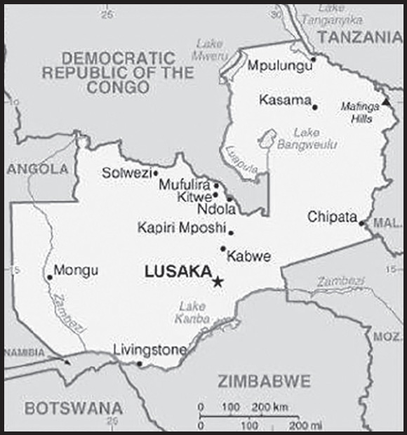
Location: Southern Africa, east of Angola, south of the Democratic Republic of the Congo
Geographic coordinates: 15 00 S, 30 00 E
Map references: Africa
Area: total: 752,618 sq km
land: 743,398 sq km
water: 9,220 sq km
comparison ranking: total 40
Area - comparative: almost five times the size of Georgia; slightly larger than Texas
Land boundaries: total: 6,043.15 km
border countries (8): Angola 1,065 km; Botswana 0.15 km; Democratic Republic of the Congo 2,332 km; Malawi 847 km; Mozambique 439 km; Namibia 244 km; Tanzania 353 km; Zimbabwe 763 km
Coastline: 0 km (landlocked)
Maritime claims: none (landlocked)
Climate: tropical; modified by altitude; rainy season (October to April)
Terrain: mostly high plateau with some hills and mountains
Elevation: highest point: Mafinga Central 2,330 m
lowest point: Zambezi river 329 m
mean elevation: 1,138 m
Natural resources: copper, cobalt, zinc, lead, coal, emeralds, gold, silver, uranium, hydropower
Land use: agricultural land: 31.7% (2018 est.)
arable land: 4.8% (2018 est.)
permanent crops: 0% (2018 est.)
permanent pasture: 26.9% (2018 est.)
forest: 66.3% (2018 est.)
other: 2% (2018 est.)
Irrigated land: 1,560 sq km (2012)
Major lakes (area sq km): fresh water lake(s): Lake Tanganyika (shared with Democratic Republic of Congo, Tanzania, and Burundi) - 32,000 sq km; Lake Mweru (shared with Democratic Republic of Congo) - 4,350 sq km; Lake Bangweulu - 4,000-15,000 sq km seasonal variation
Major rivers (by length in km): Congo river source (shared with Angola, Republic of Congo, and Democratic Republic of Congo [m]) - 4,700 km;
Zambezi river source (shared with Angola, Namibia, Botswana, Zimbabwe, and Mozambique [m]) - 2,740 km
note – [s] after country name indicates river source; [m] after country name indicates river mouth
Major watersheds (area sq km): Atlantic Ocean drainage: Congo (3,730,881 sq km)
Indian Ocean drainage: Zambezi (1,332,412 sq km)
Major aquifers: Upper Kalahari-Cuvelai-Upper Zambezi Basin
Population distribution: one of the highest levels of urbanization in Africa; high density in the central area, particularly around the cities of Lusaka, Ndola, Kitwe, and Mufulira as shown in this population distribution map
Natural hazards: periodic drought; tropical storms (November to April)
Geography - note: landlocked; the Zambezi forms a natural riverine boundary with Zimbabwe; Lake Kariba on the Zambia-Zimbabwe border forms the world’s largest reservoir by volume (180 cu km; 43 cu mi)
PEOPLE AND SOCIETY
Population: 20,216,029 (2023 est.)
comparison ranking: 63
Nationality: noun: Zambian(s)
adjective: Zambian
Ethnic groups: Bemba 21%, Tonga 13.6%, Chewa 7.4%, Lozi 5.7%, Nsenga 5.3%, Tumbuka 4.4%, Ngoni 4%, Lala 3.1%, Kaonde 2.9%, Namwanga 2.8%, Lunda (north Western) 2.6%, Mambwe 2.5%, Luvale 2.2%, Lamba 2.1%, Ushi 1.9%, Lenje 1.6%, Bisa 1.6%, Mbunda 1.2%, other 13.8%, unspecified 0.4% (2010 est.)
Languages: Bemba 33.4%, Nyanja 14.7%, Tonga 11.4%, Lozi 5.5%, Chewa 4.5%, Nsenga 2.9%, Tumbuka 2.5%, Lunda (North Western) 1.9%, Kaonde 1.8%, Lala 1.8%, Lamba 1.8%, English (official) 1.7%, Luvale 1.5%, Mambwe 1.3%, Namwanga 1.2%, Lenje 1.1%, Bisa 1%, other 9.7%, unspecified 0.2% (2010 est.)
note: Zambia is said to have over 70 languages, although many of these may be considered dialects; all of Zambia’s major languages are members of the Bantu family; Chewa and Nyanja are mutually intelligible dialects
Religions: Protestant 75.3%, Roman Catholic 20.2%, other 2.7% (includes Muslim, Buddhist, Hindu, and Baha’i), none 1.8% (2010 est.)
Demographic profile: Zambia’s poor, youthful population consists primarily of Bantu-speaking people representing nearly 70 different ethnicities. Zambia’s high fertility rate continues to drive rapid population growth, averaging almost 3% annually between 2000 and 2010, and reaching over 3.3% in 2022. The country’s total fertility rate has fallen by less than 1.5 children per woman during the last 30 years and still averages among the world’s highest, almost 6 children per woman, largely because of the country’s lack of access to family planning services, education for girls, and employment for women. Zambia also exhibits wide fertility disparities based on rural or urban location, education, and income. Poor, uneducated women from rural areas are more likely to marry young, to give birth early, and to have more children, viewing children as a sign of prestige and recognizing that not all of their children will live to adulthood. HIV/AIDS is prevalent in Zambia and contributes to its low life expectancy.
Zambian emigration is low compared to many other African countries and is comprised predominantly of the well-educated. The small amount of brain drain, however, has a major impact in Zambia because of its limited human capital and lack of educational infrastructure for developing skilled professionals in key fields. For example, Zambia has few schools for training doctors, nurses, and other health care workers. Its spending on education is low compared to other Sub-Saharan countries.
Age structure: 0-14 years: 42.49% (male 4,334,425/female 4,255,464)
15-64 years: 54.77% (male 5,529,526/female 5,541,857)
65 years and over: 2.74% (2023 est.) (male 250,984/female 303,773)
Dependency ratios: total dependency ratio: 81.8
youth dependency ratio: 78.7
elderly dependency ratio: 3.2
potential support ratio: 31.6 (2021 est.)
Median age: total: 18.2 years (2023 est.)
male: 18 years
female: 18.4 years
comparison ranking: total 218
Population growth rate: 2.86% (2023 est.)
comparison ranking: 12
Birth rate: 34.5 births/1,000 population (2023 est.)
comparison ranking: 16
Death rate: 6 deaths/1,000 population (2023 est.)
comparison ranking: 158
Net migration rate: 0.2 migrant(s)/1,000 population (2023 est.)
comparison ranking: 78
Population distribution: one of the highest levels of urbanization in Africa; high density in the central area, particularly around the cities of Lusaka, Ndola, Kitwe, and Mufulira as shown in this population distribution map
Urbanization: urban population: 46.3% of total population (2023)
rate of urbanization: 4.15% annual rate of change (2020-25 est.)
Major urban areas - population: 3.181 million LUSAKA (capital), 763,000 Kitwe (2023)
Sex ratio: at birth: 1.03 male(s)/female
0-14 years: 1.02 male(s)/female
15-64 years: 1 male(s)/female
65 years and over: 0.83 male(s)/female
total population: 1 male(s)/female (2023 est.)
Mother’s mean age at first birth: 19.2 years (2018 est.)
note: data represents median age at first birth among women 20-49
Maternal mortality ratio: 135 deaths/100,000 live births (2020 est.)
comparison ranking: 56
Infant mortality rate: total: 36.3 deaths/1,000 live births (2023 est.)
male: 39.7 deaths/1,000 live births
female: 32.8 deaths/1,000 live births
comparison ranking: total 38
Life expectancy at birth: total population: 66.6 years (2023 est.)
male: 64.9 years
female: 68.4 years
comparison ranking: total population 199
Total fertility rate: 4.49 children born/woman (2023 est.)
comparison ranking: 18
Gross reproduction rate: 2.21 (2023 est.)
Contraceptive prevalence rate: 49.6% (2018)
Drinking water source: improved: urban: 90.2% of population
rural: 56.6% of population
total: 71.6% of population
unimproved: urban: 9.8% of population
rural: 43.4% of population
total: 28.4% of population (2020 est.)
Current health expenditure: 5.6% of GDP (2020)
Physicians density: 1.17 physicians/1,000 population (2018)
Hospital bed density: 2 beds/1,000 population
Sanitation facility access: improved: urban: 76.3% of population
rural: 31.9% of population
total: 51.7% of population
unimproved: urban: 23.7% of population
rural: 68.1% of population
total: 48.3% of population (2020 est.)
Major infectious diseases: degree of risk: very high (2023)
food or waterborne diseases: bacterial and protozoal diarrhea, hepatitis A, and typhoid fever
vectorborne diseases: malaria and dengue fever
water contact diseases: schistosomiasis
animal contact diseases: rabies
note: on 31 August 2023, the US Centers for Disease Control and Prevention (CDC) issued a Travel Alert for polio in Africa; Zambia is currently considered a high risk to travelers for circulating vaccine-derived polioviruses (cVDPV); vaccine-derived poliovirus (VDPV) is a strain of the weakened poliovirus that was initially included in oral polio vaccine (OPV) and that has changed over time and behaves more like the wild or naturally occurring virus; this means it can be spread more easily to people who are unvaccinated against polio and who come in contact with the stool or respiratory secretions, such as from a sneeze, of an “infected” person who received oral polio vaccine; the CDC recommends that before any international travel, anyone unvaccinated, incompletely vaccinated, or with an unknown polio vaccination status should complete the routine polio vaccine series; before travel to any high-risk destination, the CDC recommends that adults who previously completed the full, routine polio vaccine series receive a single, lifetime booster dose of polio vaccine
Obesity - adult prevalence rate: 8.1% (2016)
comparison ranking: 155
Alcohol consumption per capita: total: 3.82 liters of pure alcohol (2019 est.)
beer: 1.26 liters of pure alcohol (2019 est.)
wine: 0.04 liters of pure alcohol (2019 est.)
spirits: 0.36 liters of pure alcohol (2019 est.)
other alcohols: 2.16 liters of pure alcohol (2019 est.)
comparison ranking: total 98
Tobacco use: total: 14.4% (2020 est.)
male: 25.1% (2020 est.)
female: 3.7% (2020 est.)
comparison ranking: total 107
Children under the age of 5 years underweight: 11.8% (2018/19)
comparison ranking: 46
Currently married women (ages 15-49): 53.3% (2023 est.)
Child marriage: women married by age 15: 5.2%
women married by age 18: 29%
men married by age 18: 2.8% (2018 est.)
Education expenditures: 3.7% of GDP (2020)
comparison ranking: 131
Literacy: definition: age 15 and over can read and write English
total population: 86.7%
male: 90.6%
female: 83.1% (2018)
Youth unemployment rate (ages 15-24): total: 26.1% (2021 est.)
male: 26.7%
female: 25.4%
comparison ranking: total 59
ENVIRONMENT
Environment - current issues: air pollution and resulting acid rain in the mineral extraction and refining region; chemical runoff into watersheds; loss of biodiversity; poaching seriously threatens rhinoceros, elephant, antelope, and large cat populations; deforestation; soil erosion; desertification; lack of adequate water treatment presents human health risks
Environment - international agreements: party to: Biodiversity, Climate Change, Climate Change-Kyoto Protocol, Climate Change-Paris Agreement, Comprehensive Nuclear Test Ban, Desertification, Endangered Species, Hazardous Wastes, Law of the Sea, Nuclear Test Ban, Ozone Layer Protection, Wetlands
signed, but not ratified: none of the selected agreements
Climate: tropical; modified by altitude; rainy season (October to April)
Land use: agricultural land: 31.7% (2018 est.)
arable land: 4.8% (2018 est.)
permanent crops: 0% (2018 est.)
permanent pasture: 26.9% (2018 est.)
forest: 66.3% (2018 est.)
other: 2% (2018 est.)
Urbanization: urban population: 46.3% of total population (2023)
rate of urbanization: 4.15% annual rate of change (2020-25 est.)
Food insecurity: severe localized food insecurity: due to reduced incomes and localized shortfalls in cereal production - cereal production declined to a below-average level in 2022 and along with the impact of rising food prices, the number of food insecure is foreseen to increase at the end of 2022 to levels above the 1.6 million people estimated in the first quarter of 2022 (2022)
Revenue from forest resources: 4.45% of GDP (2018 est.)
comparison ranking: 15
Revenue from coal: 0.04% of GDP (2018 est.)
comparison ranking: 33
Air pollutants: particulate matter emissions: 16.9 micrograms per cubic meter (2019 est.)
carbon dioxide emissions: 5.14 megatons (2016 est.)
methane emissions: 14.1 megatons (2020 est.)
Waste and recycling: municipal solid waste generated annually: 2,608,268 tons (2002 est.)
Major lakes (area sq km): fresh water lake(s): Lake Tanganyika (shared with Democratic Republic of Congo, Tanzania, and Burundi) - 32,000 sq km; Lake Mweru (shared with Democratic Republic of Congo) - 4,350 sq km; Lake Bangweulu - 4,000-15,000 sq km seasonal variation
Major rivers (by length in km): Congo river source (shared with Angola, Republic of Congo, and Democratic Republic of Congo [m]) - 4,700 km; Zambezi river source (shared with Angola, Namibia, Botswana, Zimbabwe, and Mozambique [m]) - 2,740 km
note – [s] after country name indicates river source; [m] after country name indicates river mouth
Major watersheds (area sq km): Atlantic Ocean drainage: Congo (3,730,881 sq km)
Indian Ocean drainage: Zambezi (1,332,412 sq km)
Major aquifers: Upper Kalahari-Cuvelai-Upper Zambezi Basin
Total water withdrawal: municipal: 290 million cubic meters (2020 est.)
industrial: 130 million cubic meters (2020 est.)
agricultural: 1.15 billion cubic meters (2020 est.)
Total renewable water resources: 104.8 billion cubic meters (2020 est.)
GOVERNMENT
Country name: conventional long form: Republic of Zambia
conventional short form: Zambia
former: Northern Rhodesia
etymology: name derived from the Zambezi River, which flows through the western part of the country and forms its southern border with neighboring Zimbabwe
Government type: presidential republic
Capital: name: Lusaka
geographic coordinates: 15 25 S, 28 17 E
time difference: UTC+2 (7 hours ahead of Washington, DC, during Standard Time)
etymology: named after a village called Lusaka, located at Manda Hill, near where Zambia’s National Assembly building currently stands; the village was named after a headman (chief) LUSAKASA
Administrative divisions: 10 provinces; Central, Copperbelt, Eastern, Luapula, Lusaka, Muchinga, Northern, North-Western, Southern, Western
Independence: 24 October 1964 (from the UK)
National holiday: Independence Day, 24 October (1964)
Constitution: history: several previous; latest adopted 24 August 1991, promulgated 30 August 1991
amendments: proposed by the National Assembly; passage requires two-thirds majority vote by the Assembly in two separate readings at least 30 days apart; passage of amendments affecting fundamental rights and freedoms requires approval by at least one half of votes cast in a referendum prior to consideration and voting by the Assembly; amended 1996, 2015, 2016; note - in late 2020, an amendment which would have altered the structure of the constitution was defeated in the National Assembly
Legal system: mixed legal system of English common law and customary law
International law organization participation: has not submitted an ICJ jurisdiction declaration; accepts ICCt jurisdiction
Citizenship: citizenship by birth: only if at least one parent is a citizen of Zambia
citizenship by descent only: yes, if at least one parent was a citizen of Zambia
dual citizenship recognized: yes
residency requirement for naturalization: 5 years for those with an ancestor who was a citizen of Zambia, otherwise 10 years residency is required
Suffrage: 18 years of age; universal
Executive branch: chief of state: President Hakainde HICHILEMA (since 24 August 2021); Vice President Mutale NALUMANGO (since 24 August 2021); note - the president is both chief of state and head of government
head of government: President Hakainde HICHILEMA (since 24 August 2021); Vice President Mutale NALUMANGO (since 24 August 2021)
cabinet: Cabinet appointed by president from among members of the National Assembly
elections/appointments: president directly elected by absolute majority popular vote in 2 rounds if needed for a 5-year term (eligible for a second term); last held on 12 August 2021 (next to be held in 2026)
election results: 2021: Hakainde HICHILEMA elected president; percent of the vote - Hakainde HICHILEMA (UPND) 57.9%, Edgar LUNGU (PF) 37.3%, other 4.8%
2016: Edgar LUNGU reelected president; percent of vote - Edgar LUNGU (PF) 50.4%, Hakainde HICHILEMA (UPND) 47.6%, other 2%
Legislative branch: description: unicameral National Assembly (167 seats statutory, 166 seats current; 156 members directly elected in single-seat constituencies by simple majority vote in 2 rounds if needed, and up to 8 appointed by the president; members serve 5-year terms); 3 ex-officio members elected by National Assembly membership
elections: last held on 12 August 2021 (next to be held in 2026)
election results: percent of vote by party - UPND 53.9%, PF 38.1%, PNUP 0.6%, independent 7.4%; seats by party - UPND 82, PF 62, PNUP 1, independent 11; composition - men 136, women 20, percent of women 13.5%; composition - men 141, women 25, percent of women 15.1%
Judicial branch: highest court(s): Supreme Court (consists of the chief justice, deputy chief justice, and at least 11 judges); Constitutional Court (consists of the court president, vice president, and 11 judges); note - the Constitutional Court began operation in June 2016
judge selection and term of office: Supreme Court and Constitutional Court judges appointed by the president of the republic upon the advice of the 9-member Judicial Service Commission, which is headed by the chief justice, and ratified by the National Assembly; judges normally serve until age 65
subordinate courts: Court of Appeal; High Court; Industrial Relations Court; subordinate courts (3 levels, based on upper limit of money involved); Small Claims Court; local courts (2 grades, based on upper limit of money involved)
Political parties and leaders: Alliance for Democracy and Development or ADD [Charles MILUPI]
Forum for Democracy and Development or FDD [Edith NAWAKWI]
Movement for Multiparty Democracy or MMD [Dr. Nevers MUMBA]
Party of National Unity and Progress or PNUP [Highvie HAMUDUDU]
Patriotic Front or PF [Edgar LUNGU]
United Party for National Development or UPND [Hakainde HICHILEMA]
International organization participation: ACP, AfDB, AU, C, COMESA, EITI (compliant country), FAO, G-77, IAEA, IBRD, ICAO, ICCt, ICRM, IDA, IFAD, IFC, IFRCS, ILO, IMF, Interpol, IOC, IOM, IPU, ISO (correspondent), ITSO, ITU, ITUC (NGOs), MIGA, MONUSCO, NAM, OPCW, PCA, SADC, UN, UNCTAD, UNDOF, UNESCO, UNHCR, UNIDO, UNISFA, UNMIL, UNMISS, UNOCI, UNWTO, UPU, WCO, WHO, WIPO, WMO, WTO
Diplomatic representation in the US: chief of mission: Ambassador Chibamba KANYAMA (since 30 June 2023)
chancery: 2200 R Street NW, Washington, DC 20008
telephone: [1] (202) 234-4009
FAX: [1] (202) 332-0826
email address and website: info@zambiaembassy.org
https://www.zambiaembassy.org/
Diplomatic representation from the US: chief of mission: Ambassador Michael C. GONZALES (since 16 September 2022)
embassy: Eastern end of Kabulonga Road, Ibex Hill, Lusaka
mailing address: 2310 Lusaka Place, Washington DC 20521-2310
telephone: [260] (0) 211-357-000
FAX: [260] (0) 211-357-224
email address and website: ACSLusaka@state.gov
Flag description: green field with a panel of three vertical bands of red (hoist side), black, and orange below a soaring orange eagle, on the outer edge of the flag; green stands for the country’s natural resources and vegetation, red symbolizes the struggle for freedom, black the people of Zambia, and orange the country’s mineral wealth; the eagle represents the people’s ability to rise above the nation’s problems
National symbol(s): African fish eagle; national colors: green, red, black, orange
National anthem: name: “Lumbanyeni Zambia” (Stand and Sing of Zambia, Proud and Free)
lyrics/music: multiple/Enoch Mankayi SONTONGA
note: adopted 1964; the melody, from the popular song “God Bless Africa,” is the same as that of Tanzania but with different lyrics; the melody is also incorporated into South Africa’s anthem
National heritage: total World Heritage Sites: 1 (natural)
selected World Heritage Site locales: Mosi-oa-Tunya/Victoria Falls
ECONOMY
Economic overview: lower middle-income Sub-Saharan economy; major copper exporter; high public debt is held mostly by China; systemic corruption; one of youngest and fastest growing labor forces; regional hydroelectricity exporter; extreme rural poverty
Real GDP (purchasing power parity): $63.03 billion (2021 est.)
$60.259 billion (2020 est.)
$61.986 billion (2019 est.)
note: data are in 2017 dollars
comparison ranking: 104
Real GDP growth rate: 4.6% (2021 est.)
-2.79% (2020 est.)
1.44% (2019 est.)
comparison ranking: 101
Real GDP per capita: $3,200 (2021 est.)
$3,200 (2020 est.)
$3,400 (2019 est.)
note: data are in 2017 dollars
comparison ranking: 194
GDP (official exchange rate): $25.71 billion (2017 est.)
Inflation rate (consumer prices): 22.02% (2021 est.)
15.73% (2020 est.)
9.15% (2019 est.)
comparison ranking: 15
Credit ratings:
Fitch rating: RD (2020)
Moody’s rating: Ca (2020)
Standard & Poors rating: SD (2020)
note: The year refers to the year in which the current credit rating was first obtained.
GDP - composition, by sector of origin: agriculture: 7.5% (2017 est.)
industry: 35.3% (2017 est.)
services: 57% (2017 est.)
comparison rankings: services 143; industry 46; agriculture 106
GDP - composition, by end use: household consumption: 52.6% (2017 est.)
government consumption: 21% (2017 est.)
investment in fixed capital: 27.1% (2017 est.)
investment in inventories: 1.2% (2017 est.)
exports of goods and services: 43% (2017 est.)
imports of goods and services: -44.9% (2017 est.)
Agricultural products: sugar cane, cassava, maize, milk, vegetables, soybeans, beef, tobacco, wheat, groundnuts
Industries: copper mining and processing, emerald mining, construction, foodstuffs, beverages, chemicals, textiles, fertilizer, horticulture
Industrial production growth rate: 4.18% (2021 est.)
comparison ranking: 100
Labor force: 8.113 million (2021 est.)
comparison ranking: 65
Labor force - by occupation: agriculture: 54.8%
industry: 9.9%
services: 35.3% (2017 est.)
Unemployment rate: 13.03% (2021 est.)
12.85% (2020 est.)
12.52% (2019 est.)
comparison ranking: 51
Youth unemployment rate (ages 15-24): total: 26.1% (2021 est.)
male: 26.7%
female: 25.4%
comparison ranking: total 59
Population below poverty line: 54.4% (2015 est.)
Gini Index coefficient - distribution of family income: 57.1 (2015 est.)
comparison ranking: 3
Household income or consumption by percentage share: lowest 10%: 1.5%
highest 10%: 47.4% (2010)
Budget: revenues: $4.758 billion (2019 est.)
expenditures: $7.044 billion (2019 est.)
Budget surplus (+) or deficit (-): -7.3% (of GDP) (2017 est.)
comparison ranking: 195
Public debt: 103.7% of GDP (2020 est.)
61.93% of GDP (2019 est.)
59.71% of GDP (2018 est.)
comparison ranking: 20
Taxes and other revenues: 16.44% (of GDP) (2020 est.)
comparison ranking: 129
Fiscal year: calendar year
Current account balance: $2.531 billion (2021 est.)
$961.821 million (2020 est.)
$140.712 million (2019 est.)
comparison ranking: 40
Exports: $11.716 billion (2021 est.) note: data are in current year dollars
$8.558 billion (2020 est.) note: data are in current year dollars
$8.258 billion (2019 est.) note: data are in current year dollars
comparison ranking: 97
Exports - partners: Switzerland 32%, China 14%, Namibia 12%, Democratic Republic of the Congo 9%, Singapore 8% (2020)
Exports - commodities: copper, gold, gemstones, tobacco, cement (2020)
Imports: $7.701 billion (2021 est.) note: data are in current year dollars
$7.049 billion (2020 est.) note: data are in current year dollars
$8.036 billion (2019 est.) note: data are in current year dollars
comparison ranking: 126
Imports - partners: South Africa 31%, China 16%, United Arab Emirates 9%, Democratic Republic of the Congo 6%, India 5% (2020)
Imports - commodities: copper, petroleum, fertilizers, packaged medicines, delivery trucks (2020)
Reserves of foreign exchange and gold: $2.754 billion (31 December 2021 est.)
$1.203 billion (31 December 2020 est.)
$1.449 billion (31 December 2019 est.)
comparison ranking: 123
Debt - external: $11.66 billion (31 December 2017 est.)
$9.562 billion (31 December 2016 est.)
comparison ranking: 109
Exchange rates: Zambian kwacha (ZMK) per US dollar -
Exchange rates: 20.018 (2021 est.)
18.344 (2020 est.)
12.89 (2019 est.)
10.458 (2018 est.)
9.518 (2017 est.)
ENERGY
Electricity access: population without electricity: (2020) 12 million
electrification - total population: 46.6% (2021)
electrification - urban areas: 85.7% (2021)
electrification - rural areas: 14.5% (2021)
Electricity: installed generating capacity: 3.065 million kW (2020 est.)
consumption: 13,409,685,000 kWh (2019 est.)
exports: 976 million kWh (2019 est.)
imports: 198 million kWh (2019 est.)
transmission/distribution losses: 1,811,480,000 kWh (2019 est.)
comparison rankings: installed generating capacity 106; transmission/distribution losses 91; imports 103; exports 62; consumption 86
Electricity generation sources: fossil fuels: 13% of total installed capacity (2020 est.)
solar: 0.9% of total installed capacity (2020 est.)
hydroelectricity: 85.5% of total installed capacity (2020 est.)
biomass and waste: 0.5% of total installed capacity (2020 est.)
Coal: production: 1.116 million metric tons (2020 est.)
consumption: 1.176 million metric tons (2020 est.)
exports: 39,000 metric tons (2020 est.)
imports: 99,000 metric tons (2020 est.)
proven reserves: 45 million metric tons (2019 est.)
Petroleum: total petroleum production: 0 bbl/day (2021 est.)
refined petroleum consumption: 25,300 bbl/day (2019 est.)
crude oil and lease condensate exports: 0 bbl/day (2018 est.)
crude oil and lease condensate imports: 12,400 bbl/day (2018 est.)
crude oil estimated reserves: 0 barrels (2021 est.)
Refined petroleum products - production: 13,120 bbl/day (2015 est.)
comparison ranking: 98
Refined petroleum products - exports: 371 bbl/day (2015 est.)
comparison ranking: 113
Refined petroleum products - imports: 10,150 bbl/day (2015 est.)
comparison ranking: 149
Carbon dioxide emissions: 6.798 million metric tonnes of CO2 (2019 est.)
from coal and metallurgical coke: 3.186 million metric tonnes of CO2 (2019 est.)
from petroleum and other liquids: 3.612 million metric tonnes of CO2 (2019 est.)
from consumed natural gas: 0 metric tonnes of CO2 (2019 est.)
comparison ranking: total emissions 127
Energy consumption per capita: 11.595 million Btu/person (2019 est.)
comparison ranking: 149
COMMUNICATIONS
Telephones - fixed lines: total subscriptions: 66,000 (2021 est.)
subscriptions per 100 inhabitants: (2021 est.) less than 1
comparison ranking: total subscriptions 146
Telephones - mobile cellular: total subscriptions: 20 million (2021 est.)
subscriptions per 100 inhabitants: 100 (2021 est.)
comparison ranking: total subscriptions 60
Telecommunication systems: general assessment: following elections held in August 2021, the new government immediately established a Ministry of Technology and Science to promote the use of ICT in developing economic growth and social inclusion; this focus on ICT, and on telecoms in particular, has been central to government strategies for some years; as part of the Smart Zambia initiative, investment has been made in data centers, a computer assembly plant, ICT training centers, and a Smart Education program; these efforts have been combined with the extension of broadband access and improved connectivity to international submarine cables; in turn, this has resulted in a considerable reduction in fixed-line and mobile access pricing for end-users; mobile network operators continue to invest in 3G and LTE-based services, the government contracted to upgrade the state-owned mobile infrastructure for 5G services; delays in holding spectrum have stymied the development of 5G thus far; in mid-2021 the regulator completed a consultation of auctioning low, medium, and high band spectrum for 5G, aiming to provide sufficient spectrum to meet the anticipated increase in data traffic in coming years; fixed-line broadband services remain underdeveloped (2022)
domestic: fixed-line teledensity less than 1 per 100 and mobile-cellular is 100 per 100 (2021)
international: country code - 260; multiple providers operate overland fiber optic routes via Zimbabwe/South Africa, Botswana/Namibia and Tanzania provide access to the major undersea cables
Broadcast media: according to the Independent Broadcast Authority, there are 137 radio stations and 47 television stations in Zambia; out of the 137 radio stations, 133 are private (categorized as either commercial or community radio stations), while 4 are public-owned; state-owned Zambia National Broadcasting Corporation (ZNBC) operates 2 television channels and 3 radio stations; ZNBC owns 75% shares in GoTV, 40% in MultiChoice, and 40% in TopStar Communications Company, all of which operate in-country (2019)
Internet country code: .zm
Internet users: total: 3.99 million (2021 est.)
percent of population: 21% (2021 est.)
comparison ranking: total 109
Broadband - fixed subscriptions: total: 82,317 (2020 est.)
subscriptions per 100 inhabitants: 0.5 (2020 est.)
comparison ranking: total 131
TRANSPORTATION
National air transport system: number of registered air carriers: 3 (2020)
inventory of registered aircraft operated by air carriers: 6
annual passenger traffic on registered air carriers: 8,904 (2018)
annual freight traffic on registered air carriers: 75.08 million (2018) mt-km
Civil aircraft registration country code prefix: 9J
Airports: 88 (2021)
comparison ranking: total 64
Airports - with paved runways: 8
note: paved runways have a concrete or asphalt surface but not all have facilities for refueling, maintenance, or air traffic control; the length of a runway required for aircraft to safely operate depends on a number of factors including the type of aircraft, the takeoff weight (including passengers, cargo, and fuel), engine types, flap settings, landing speed, elevation of the airport, and average maximum daily air temperature; paved runways can reach a length of 5,000 m (16,000 ft.), but the “typical” length of a commercial airline runway is between 2,500-4,000 m (8,000-13,000 ft.)
Airports - with unpaved runways: 80
note: unpaved runways have a surface composition such as grass or packed earth and are most suited to the operation of light aircraft; unpaved runways are usually short, often less than 1,000 m (3,280 ft.) in length; airports with unpaved runways often lack facilities for refueling, maintenance, or air traffic control
Pipelines: 771 km oil (2013)
Railways: total: 3,126 km (2014)
narrow gauge: 3,126 km (2014) 1.067-m gauge
note: includes 1,860 km of the Tanzania-Zambia Railway Authority (TAZARA)
comparison ranking: total 57
Roadways: total: 67,671 km (2018)
paved: 14,888 km (2018)
unpaved: 52,783 km (2018)
comparison ranking: total 70
Waterways: 2,250 km (2010) (includes Lake Tanganyika and the Zambezi and Luapula Rivers)
comparison ranking: 39
Merchant marine: total: 2 (2022)
by type: general cargo 1, oil tanker 1
comparison ranking: total 177
Ports and terminals: river port(s): Mpulungu (Zambezi)
MILITARY AND SECURITY
Military and security forces: Zambia Defense Force (ZDF): Zambia Army, Zambia Air Force, Zambia National Service; Defense Force Medical Service
Ministry of Home Affairs and Internal Security: Zambia Police (includes a paramilitary battalion) (2023)
note: the Zambia National Service is a support organization that also does public work projects
Military expenditures: 1.2% of GDP (2022 est.)
1.3% of GDP (2021 est.)
1.3% of GDP (2020 est.)
1.3% of GDP (2019 est.)
1.4% of GDP (2018 est.)
comparison ranking: 112
Military and security service personnel strengths: approximately 17,000 active troops (15,000 Army; 2,000 Air) (2023)
Military equipment inventories and acquisitions: the ZDF’s inventory is largely comprised of Chinese, Russian, and Soviet-era armaments; in recent years, leading suppliers have included China and Italy (2023)
Military service age and obligation: 18-25 years of age (17 with parental consent) for voluntary military service for men and women; no conscription; 12-year enlistment period (7 years active, 5 in the Reserves) (2023)
note: Zambia had military conscription from 1975-1980
Military deployments: 925 Central African Republic (MINUSCA) (2023)
Military - note: the Zambia Defense Forces are responsible for preserving the country’s sovereignty and territorial integrity; it also has some domestic security responsibilities in cases of national emergency; border security and support to African and UN peacekeeping operations are priorities; the ZDF is part of the Southern Africa Development Community (SADC) Standby Force and participates in multinational training exercises; it has received training assistance from China and the US
the Army’s principal combat forces are 3 light infantry brigades, supported by armored and artillery regiments; it also has a maritime patrol unit to provide security for the country’s lakes and rivers; the Air Force has small numbers of mostly Chinese-made combat aircraft and helicopters
the ZDF traces its roots to the Northern Rhodesia Regiment, which was raised by the British colonial government to fight in World War II; the ZDF was established in 1964 from units of the dissolved Federation of Rhodesia and Nyasaland armed forces; it participated in a number of regional conflicts during the 1970s and 1980s; Zambia actively supported independence movements such as the Union for the Total Liberation of Angola (UNITA), the Zimbabwe African People’s Union (ZAPU), the African National Congress of South Africa (ANC), and the South-West Africa People’s Organization (SWAPO) (2023)
TRANSNATIONAL ISSUES
Disputes - international: Zambia-Angola: because the straight-line segments along the left bank (Zambian side) of the Cuando/Kwando River do not conform with the physical alignment of the unstable shoreline, Zambian residents in some areas have settled illegally on sections of shoreline that fall on the Angolan side of the boundary
Zambia-Democratic Republic of Congo(DRC): boundary commission continues discussions over Congolese-administered triangle of land on the right bank of the Lunkinda River claimed by Zambia near the DRC village of Pweto
Zambia-Tanzania: some drug smuggling may take place across the Zambia-Tanzania border; there are no known current territorial issues, as both states have continued to recognize the colonial boundaries last modified in 1937; the boundary in Lake Tanganyika remains undefined.
Zambia-Zimbabwe: in 2004, Zimbabwe dropped objections to plans between Botswana and Zambia to build a bridge over the Zambezi River, thereby de facto recognizing a short, but not clearly delimited, Botswana-Zambia boundary in the river; in May 2021, Botswana and Zambia agreed in principle to let Zimbabwe be a partner in the bridge project as it enters its lasts phase
Refugees and internally displaced persons: refugees (country of origin): 59,943 (Democratic Republic of the Congo) (refugees and asylum seekers), 8,436 (Burundi) (2023)
Illicit drugs: transshipment point for moderate amounts of methaqualone, small amounts of heroin, and cocaine bound for southern Africa and possibly Europe; a poorly developed financial infrastructure coupled with a government commitment to combating money laundering make it an unattractive venue for money launderers; major consumer of cannabis
ZIMBABWE
INTRODUCTION
Background: The hunter-gatherer San people first inhabited the area that eventually became Zimbabwe. Farming communities migrated to the area around A.D. 500 during the Bantu expansion, and Shona-speaking societies began to develop in the Limpopo valley and Zimbabwean highlands around the 9th century. These societies traded with Arab merchants on the Indian Ocean coast and organized under the Kingdom of Mapungubwe in the 11th century. A series of powerful trade-oriented Shona states succeeded Mapungubwe, including the Kingdom of Zimbabwe (ca. 1220-1450), Kingdom of Mutapa (ca. 1450-1760), and the Rozwi Empire. The Rozwi Empire expelled Portuguese colonists from the Zimbabwean plateau but was eventually conquered in 1838 by the Ndebele clan of Zulu general MZILIKAZI during the era of conflict and population displacement known as the Mfecane. In the 1880s, colonists arrived with the British South Africa Company (BSAC) and obtained a written concession for mining rights from Ndebele King LOBENGULA. The king later disavowed the concession and accused the BSAC agents of deceit. The BSAC annexed Mashonaland and subsequently conquered Matabeleland by force during the First Matabele War of 1893-1894 to establish company rule over the territory. BSAC holdings south of the Zambezi River were annexed by the UK in 1923 and became the British colony of Southern Rhodesia. The 1930 Land Apportionment Act restricted Black land ownership and established structural racial inequalities that would favor the White minority for decades. A new constitution in 1961 further cemented White minority rule.
In 1965, the government under White Prime Minister Ian SMITH unilaterally declared its independence from the UK. London did not recognize Rhodesia’s independence and demanded more voting rights for the Black majority in the country. International diplomacy and a liberation struggle by Black Zimbabweans led to biracial elections in 1979 and independence (as Zimbabwe) in 1980. Robert MUGABE, who led the uprising and became the nation’s first prime minister, was the country’s only ruler (as president since 1987) from independence until November 2017, when loss of support from his political party and the country’s military forced his resignation. In the mid-1980s, the government tortured and killed thousands of civilians in a crackdown on dissent known as the Gukurahundi campaign. Economic mismanagement and chaotic implementation of land redistribution policies following independence periodically crippled the economy and resulted in widespread shortages of basic commodities. General elections in 2002, 2008, and 2013 were severely flawed and widely condemned but allowed MUGABE to remain president. In November 2017, Vice President Emmerson MNANGAGWA became president following a military intervention led by Constantino CHIWENGA that forced MUGABE to resign, and MNANGAGWA cemented power by sidelining rivals Grace MUGABE (Robert MUGABE’s wife) and her faction of the ruling Zimbabwe African National Union-Patriotic Front party. In July 2018, MNANGAGWA won the presidential election after a close contest with opposition candidate Nelson CHAMISA. MNANGAGWA has maintained the government’s longstanding practice of violently disrupting protests and opposition rallies and politicizing institutions. Economic conditions remain dire under MNANGAGWA.
GEOGRAPHY
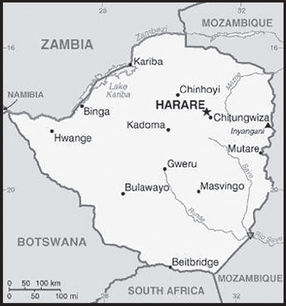
Location: Southern Africa, between South Africa and Zambia
Geographic coordinates: 20 00 S, 30 00 E
Map references: Africa
Area: total: 390,757 sq km
land: 386,847 sq km
water: 3,910 sq km
comparison ranking: total 62
Area - comparative: about four times the size of Indiana; slightly larger than Montana
Land boundaries: total: 3,229 km
border countries (4): Botswana 834 km; Mozambique 1,402 km; South Africa 230 km; Zambia 763 km
Coastline: 0 km (landlocked)
Maritime claims: none (landlocked)
Climate: tropical; moderated by altitude; rainy season (November to March)
Terrain: mostly high plateau with higher central plateau (high veld); mountains in east
Elevation: highest point: Inyangani 2,592 m
lowest point: junction of the Runde and Save Rivers 162 m
mean elevation: 961 m
Natural resources: coal, chromium ore, asbestos, gold, nickel, copper, iron ore, vanadium, lithium, tin, platinum group metals
Land use: agricultural land: 42.5% (2018 est.)
arable land: 10.9% (2018 est.)
permanent crops: 0.3% (2018 est.)
permanent pasture: 31.3% (2018 est.)
forest: 39.5% (2018 est.)
other: 18% (2018 est.)
Irrigated land: 1,740 sq km (2012)
Major rivers (by length in km): Zambezi (shared with Zambia [s]), Angola, Namibia, Botswana, and Mozambique [m]) - 2,740 km; Limpopo (shared with South Africa [s], Botswana, and Mozambique [m]) - 1,800 km
note – [s] after country name indicates river source; [m] after country name indicates river mouth
Major watersheds (area sq km): Indian Ocean drainage: Zambezi (1,332,412 sq km)
Internal (endorheic basin) drainage: Okavango Basin (863,866 sq km)
Major aquifers: Upper Kalahari-Cuvelai-Upper Zambezi Basin
Population distribution: Aside from major urban agglomerations in Harare and Bulawayo, population distribution is fairly even, with slightly greater overall numbers in the eastern half as shown in this population distribution map
Natural hazards: recurring droughts; floods and severe storms are rare
Geography - note: landlocked; the Zambezi forms a natural riverine boundary with Zambia; in full flood (February-April) the massive Victoria Falls on the river forms the world’s largest curtain of falling water; Lake Kariba on the Zambia-Zimbabwe border forms the world’s largest reservoir by volume (180 cu km; 43 cu mi)
PEOPLE AND SOCIETY
Population: 15,418,674 (2023 est.)
comparison ranking: 73
Nationality: noun: Zimbabwean(s)
adjective: Zimbabwean
Ethnic groups: African 99.4% (predominantly Shona; Ndebele is the second largest ethnic group), other 0.4%, unspecified 0.2% (2012 est.)
Languages: Shona (official; most widely spoken), Ndebele (official, second most widely spoken), English (official; traditionally used for official business), 13 minority languages (official; includes Chewa, Chibarwe, Kalanga, Koisan, Nambya, Ndau, Shangani, sign language, Sotho, Tonga, Tswana, Venda, and Xhosa)
Religions: Protestant 74.8% (includes Apostolic 37.5%, Pentecostal 21.8%, other 15.5%), Roman Catholic 7.3%, other Christian 5.3%, traditional 1.5%, Muslim 0.5%, other 0.1%, none 10.5% (2015 est.)
Demographic profile: Zimbabwe’s progress in reproductive, maternal, and child health has stagnated in recent years. According to a 2010 Demographic and Health Survey, contraceptive use, the number of births attended by skilled practitioners, and child mortality have either stalled or somewhat deteriorated since the mid-2000s. Zimbabwe’s total fertility rate has remained fairly stable at about 4 children per woman for the last two decades, although an uptick in the urban birth rate in recent years has caused a slight rise in the country’s overall fertility rate. Zimbabwe’s HIV prevalence rate dropped from approximately 29% to 15% since 1997 but remains among the world’s highest and continues to suppress the country’s life expectancy rate. The proliferation of HIV/AIDS information and prevention programs and personal experience with those suffering or dying from the disease have helped to change sexual behavior and reduce the epidemic.
Historically, the vast majority of Zimbabwe’s migration has been internal – a rural-urban flow. In terms of international migration, over the last 40 years Zimbabwe has gradually shifted from being a destination country to one of emigration and, to a lesser degree, one of transit (for East African illegal migrants traveling to South Africa). As a British colony, Zimbabwe attracted significant numbers of permanent immigrants from the UK and other European countries, as well as temporary economic migrants from Malawi, Mozambique, and Zambia. Although Zimbabweans have migrated to South Africa since the beginning of the 20th century to work as miners, the first major exodus from the country occurred in the years before and after independence in 1980. The outward migration was politically and racially influenced; a large share of the white population of European origin chose to leave rather than live under a new black-majority government.
In the 1990s and 2000s, economic mismanagement and hyperinflation sparked a second, more diverse wave of emigration. This massive outmigration – primarily to other southern African countries, the UK, and the US – has created a variety of challenges, including brain drain, illegal migration, and human smuggling and trafficking. Several factors have pushed highly skilled workers to go abroad, including unemployment, lower wages, a lack of resources, and few opportunities for career growth.
Age structure: 0-14 years: 38.16% (male 2,920,951/female 2,962,652)
15-64 years: 57.32% (male 4,417,612/female 4,419,769)
65 years and over: 4.52% (2023 est.) (male 269,329/female 428,361)
Dependency ratios: total dependency ratio: 79.4
youth dependency ratio: 73.4
elderly dependency ratio: 6
potential support ratio: 16.6 (2021 est.)
Median age: total: 21 years (2023 est.)
male: 20.2 years
female: 21.8 years
comparison ranking: total 191
Population growth rate: 1.99% (2023 est.)
comparison ranking: 42
Birth rate: 29.4 births/1,000 population (2023 est.)
comparison ranking: 29
Death rate: 6.7 deaths/1,000 population (2023 est.)
comparison ranking: 131
Net migration rate: -2.9 migrant(s)/1,000 population (2023 est.)
comparison ranking: 179
Population distribution: Aside from major urban agglomerations in Harare and Bulawayo, population distribution is fairly even, with slightly greater overall numbers in the eastern half as shown in this population distribution map
Urbanization: urban population: 32.5% of total population (2023)
rate of urbanization: 2.41% annual rate of change (2020-25 est.)
Major urban areas - population: 1.578 million HARARE (capital) (2023)
Sex ratio: at birth: 1.03 male(s)/female
0-14 years: 0.99 male(s)/female
15-64 years: 1 male(s)/female
65 years and over: 0.63 male(s)/female
total population: 0.95 male(s)/female (2023 est.)
Mother’s mean age at first birth: 20.3 years (2015 est.)
note: data represents median age at first birth among women 25-49
Maternal mortality ratio: 357 deaths/100,000 live births (2020 est.)
comparison ranking: 26
Infant mortality rate: total: 34 deaths/1,000 live births (2023 est.)
male: 37.7 deaths/1,000 live births
female: 30.2 deaths/1,000 live births
comparison ranking: total 39
Life expectancy at birth: total population: 66.8 years (2023 est.)
male: 65.2 years
female: 68.5 years
comparison ranking: total population 198
Total fertility rate: 3.51 children born/woman (2023 est.)
comparison ranking: 36
Gross reproduction rate: 1.73 (2023 est.)
Contraceptive prevalence rate: 66.8% (2015)
Drinking water source: improved: urban: 97.9% of population
rural: 66.9% of population
total: 76.9% of population
unimproved: urban: 2.1% of population
rural: 33.1% of population
total: 23.1% of population (2020 est.)
Current health expenditure: 3.4% of GDP (2020)
Physicians density: 0.2 physicians/1,000 population (2020)
Hospital bed density: 1.7 beds/1,000 population (2011)
Sanitation facility access: improved: urban: 96.1% of population
rural: 49% of population
total: 64.2% of population
unimproved: urban: 3.9% of population
rural: 51% of population
total: 35.8% of population (2017 est.)
Major infectious diseases: degree of risk: high (2023)
food or waterborne diseases: bacterial and protozoal diarrhea, hepatitis A, and typhoid fever
vectorborne diseases: malaria and dengue fever
water contact diseases: schistosomiasis
animal contact diseases: rabies
Obesity - adult prevalence rate: 15.5% (2016)
comparison ranking: 126
Alcohol consumption per capita: total: 3.11 liters of pure alcohol (2019 est.)
beer: 1.2 liters of pure alcohol (2019 est.)
wine: 0.05 liters of pure alcohol (2019 est.)
spirits: 0.39 liters of pure alcohol (2019 est.)
other alcohols: 1.47 liters of pure alcohol (2019 est.)
comparison ranking: total 110
Tobacco use: total: 11.7% (2020 est.)
male: 21.8% (2020 est.)
female: 1.5% (2020 est.)
comparison ranking: total 125
Children under the age of 5 years underweight: 9.7% (2019)
comparison ranking: 57
Currently married women (ages 15-49): 61.6% (2023 est.)
Child marriage: women married by age 15: 5.4%
women married by age 18: 33.7%
men married by age 18: 1.9% (2019 est.)
Education expenditures: 3.9% of GDP (2018 est.)
comparison ranking: 123
Literacy: definition: age 15 and over can read and write English
total population: 89.7%
male: 88.3%
female: 89.7% (2021)
School life expectancy (primary to tertiary education): total: 11 years
male: 12 years
female: 11 years (2013)
Youth unemployment rate (ages 15-24): total: 7.3% (2021 est.)
male: 6.2%
female: 8.5%
comparison ranking: total 174
ENVIRONMENT
Environment - current issues: deforestation; soil erosion; land degradation; air and water pollution; the black rhinoceros herd - once the largest concentration of the species in the world - has been significantly reduced by poaching; poor mining practices have led to toxic waste and heavy metal pollution
Environment - international agreements: party to: Biodiversity, Climate Change, Climate Change-Kyoto Protocol, Climate Change-Paris Agreement, Comprehensive Nuclear Test Ban, Desertification, Endangered Species, Hazardous Wastes, Law of the Sea, Ozone Layer Protection, Wetlands
signed, but not ratified: none of the selected agreements
Climate: tropical; moderated by altitude; rainy season (November to March)
Land use: agricultural land: 42.5% (2018 est.)
arable land: 10.9% (2018 est.)
permanent crops: 0.3% (2018 est.)
permanent pasture: 31.3% (2018 est.)
forest: 39.5% (2018 est.)
other: 18% (2018 est.)
Urbanization: urban population: 32.5% of total population (2023)
rate of urbanization: 2.41% annual rate of change (2020-25 est.)
Food insecurity: widespread lack of access: due to high food prices - based on a government assessment, an estimated 3.8 million people are expected to be in need of humanitarian assistance between January and March 2023; this number is higher than the level estimated in the first quarter of 2022; the downturn in food security conditions is largely on account of poor food access resulting from prevailing high food prices and reduced incomes owing to the effects of an economic downturn; a decline in cereal production in 2022 has also aggravated conditions (2023)
Revenue from forest resources: 1.61% of GDP (2018 est.)
comparison ranking: 39
Revenue from coal: 0.4% of GDP (2018 est.)
comparison ranking: 15
Air pollutants: particulate matter emissions: 13.08 micrograms per cubic meter (2019 est.)
carbon dioxide emissions: 10.98 megatons (2016 est.)
methane emissions: 12.1 megatons (2020 est.)
Waste and recycling: municipal solid waste generated annually: 1,449,752 tons (2015 est.)
municipal solid waste recycled annually: 231,960 tons (2005 est.)
percent of municipal solid waste recycled: 16% (2005 est.)
Major rivers (by length in km): Zambezi (shared with Zambia [s]), Angola, Namibia, Botswana, and Mozambique [m]) - 2,740 km; Limpopo (shared with South Africa [s], Botswana, and Mozambique [m]) - 1,800 km
note – [s] after country name indicates river source; [m] after country name indicates river mouth
Major watersheds (area sq km): Indian Ocean drainage: Zambezi (1,332,412 sq km)
Internal (endorheic basin) drainage: Okavango Basin (863,866 sq km)
Major aquifers: Upper Kalahari-Cuvelai-Upper Zambezi Basin
Total water withdrawal: municipal: 650 million cubic meters (2020 est.)
industrial: 80 million cubic meters (2020 est.)
agricultural: 3.04 billion cubic meters (2020 est.)
Total renewable water resources: 20 billion cubic meters (2020 est.)
GOVERNMENT
Country name: conventional long form: Republic of Zimbabwe
conventional short form: Zimbabwe
former: Southern Rhodesia, Rhodesia, Zimbabwe-Rhodesia
etymology: takes its name from the Kingdom of Zimbabwe (13th-15th century) and its capital of Great Zimbabwe, the largest stone structure in pre-colonial southern Africa
Government type: presidential republic
Capital: name: Harare
geographic coordinates: 17 49 S, 31 02 E
time difference: UTC+2 (7 hours ahead of Washington, DC, during Standard Time)
etymology: named after a village of Harare at the site of the present capital; the village name derived from a Shona chieftain, NE-HARAWA, whose name meant “he who does not sleep”
Administrative divisions: 8 provinces and 2 cities* with provincial status; Bulawayo*, Harare*, Manicaland, Mashonaland Central, Mashonaland East, Mashonaland West, Masvingo, Matabeleland North, Matabeleland South, Midlands
Independence: 18 April 1980 (from the UK)
National holiday: Independence Day, 18 April (1980)
Constitution: history: previous 1965 (at Rhodesian independence), 1979 (Lancaster House Agreement), 1980 (at Zimbabwean independence); latest final draft completed January 2013, approved by referendum 16 March 2013, approved by Parliament 9 May 2013, effective 22 May 2013
amendments: proposed by the Senate or by the National Assembly; passage requires two-thirds majority vote by the membership of both houses of Parliament and assent of the president of the republic; amendments to constitutional chapters on fundamental human rights and freedoms and on agricultural lands also require approval by a majority of votes cast in a referendum; amended many times, last in 2017
Legal system: mixed legal system of English common law, Roman-Dutch civil law, and customary law
International law organization participation: has not submitted an ICJ jurisdiction declaration; non-party state to the ICCt
Citizenship: citizenship by birth: no
citizenship by descent only: the father must be a citizen of Zimbabwe; in the case of a child born out of wedlock, the mother must be a citizen
dual citizenship recognized: no
residency requirement for naturalization: 5 years
Suffrage: 18 years of age; universal
Executive branch: chief of state: President Emmerson Dambudzo MNANGAGWA (since 4 September 2023); First Vice President Constantino CHIWENGA (since 4 September 2023); note - Robert Gabriel MUGABE resigned on 21 November 2017, after ruling for 37 years
head of government: President Emmerson Dambudzo MNANGAGWA (since 4 September 2023); Vice President Constantino CHIWENGA (since 4 September 2023)
cabinet: Cabinet appointed by president, responsible to National Assembly
elections/appointments: each presidential candidate nominated with a nomination paper signed by at least 10 registered voters (at least 1 candidate from each province) and directly elected by absolute majority popular vote in 2 rounds if needed for a 5-year term (no term limits); election last held on 23 August 2023 (next to be held in 2028); co-vice presidents drawn from party leadership
election results: 2023: Emmerson MNANGAGWA elected president in 1st round of voting; percent of vote - Emmerson MNANGAGWA (ZANU-PF) 52.6%, Nelson CHAMISA (MDC-T) 44%, Wilbert MUBAIWA (MDC) 1.20%, other 3%
2018: Emmerson MNANGAGWA elected president in 1st round of voting; percent of vote - Emmerson MNANGAGWA (ZANU-PF) 50.8%, Nelson CHAMISA (MDC-T) 44.3%, Thokozani KHUPE (MDC-N) 0.9%, other 3%
Legislative branch: description: bicameral Parliament consists of:
Senate (80 seats; 60 members directly elected in multi-seat constituencies - 6 seats in each of the 10 provinces - by proportional representation vote, 16 indirectly elected by the regional governing councils, 18 reserved for the National Council Chiefs, and 2 reserved for members with disabilities; members serve 5-year terms)
National Assembly (270 seats; 210 members directly elected in single-seat constituencies by simple majority vote and 60 seats reserved for women directly elected by proportional representation vote; members serve 5-year terms)
elections: Senate - last held for elected member on 23 August 2023 (next to be held in 2028)
National Assembly - last held on 23 August 2023 (next to be held in 2028)
election results: Senate - percent of vote by party - NA; seats by party - ZANU-PF 33, CCC- 27, Chiefs 18, people with disabilities 2; composition - men 44, women 36, percent of women 45%
National Assembly - percent of vote by party - NA; seats by party - ZANU-PF 169, CCC-100, vacant-1; composition - men 193, women 86, percent of women 30.8%; note - total Parliament percent of women 34.3%
Judicial branch: highest court(s): Supreme Court (consists of the chief justice and 4 judges); Constitutional Court (consists of the chief and deputy chief justices and 9 judges)
judge selection and term of office: Supreme Court judges appointed by the president upon recommendation of the Judicial Service Commission, an independent body consisting of the chief justice, Public Service Commission chairman, attorney general, and 2-3 members appointed by the president; judges normally serve until age 65 but can elect to serve until age 70; Constitutional Court judge appointment NA; judges serve nonrenewable 15-year terms
subordinate courts: High Court; Labor Court; Administrative Court; regional magistrate courts; customary law courts; special courts
Political parties and leaders: Citizens Coalition for Change [Nelson CHAMISA]
Movement for Democratic Change - MDC-T [Douglas MWONZORA]
National People’s Congress- NPC- [Wilbert MUBAIWA]
Zimbabwe African National Union-Patriotic Front or ZANU-PF [Emmerson Dambudzo MNANGAGWA]
Zimbabwe African Peoples Union or ZAPU [Michael NKOMO]
International organization participation: ACP, AfDB, ATMIS, AU, COMESA, FAO, G-15, G-77, IAEA, IBRD, ICAO, ICRM, IDA, IFAD, IFC, IFRCS, ILO, IMF, IMO, Interpol, IOC, IOM, IPU, ISO, ITSO, ITU, ITUC (NGOs), MIGA, NAM, OPCW, PCA, SADC, UN, UNAMID, UNCTAD, UNESCO, UNIDO, UNISFA, UNMIL, UNMISS, UNOCI, UNSOM, UNWTO, UPU, WCO, WFTU (NGOs), WHO, WIPO, WMO, WTO
Diplomatic representation in the US: chief of mission: Ambassador Tadeous Tafirenyika CHIFAMBA (since 7 July 2021)
chancery: 1608 New Hampshire Avenue NW, Washington, DC 20009
telephone: [1] (202) 332-7100
FAX: [1] (202) 483-9326
email address and website: general@zimembassydc.org
Diplomatic representation from the US: chief of mission: Ambassador (vacant); Chargé d’Affaires Elaine M. FRENCH (since August 2022)
embassy: 2 Lorraine Drive, Bluffhill, Harare
mailing address: 2180 Harare Place, Washington DC 20521-2180
telephone: [263] 867-701-1000
FAX: [263] 24-233-4320
email address and website: consularharare@state.gov
Flag description: seven equal horizontal bands of green (top), yellow, red, black, red, yellow, and green with a white isosceles triangle edged in black with its base on the hoist side; a yellow Zimbabwe bird representing the long history of the country is superimposed on a red five-pointed star in the center of the triangle, which symbolizes peace; green represents agriculture, yellow mineral wealth, red the blood shed to achieve independence, and black stands for the native people
National symbol(s): Zimbabwe bird symbol, African fish eagle, flame lily; national colors: green, yellow, red, black, white
National anthem: name: “Kalibusiswe Ilizwe leZimbabwe” [Northern Ndebele language] “Simudzai Mureza WeZimbabwe” [Shona] (Blessed Be the Land of Zimbabwe)
lyrics/music: Solomon MUTSWAIRO/Fred Lecture CHANGUNDEGA
note: adopted 1994
National heritage: total World Heritage Sites: 5 (3 cultural, 2 natural)
selected World Heritage Site locales: Mana Pools National Park, Sapi, and Chewore Safari Areas (n); Great Zimbabwe National Monument (c); Khami Ruins National Monument (c); Mosi-oa-Tunya/Victoria Falls (n); Matobo Hills (c)
ECONOMY
Economic overview: low income Sub-Saharan economy; political instability, protest crackdowns, and COVID-19 have damaged economic potential; reliant on natural resource extraction and agriculture; endemic corruption; ongoing hyperinflation
Real GDP (purchasing power parity): $33.829 billion (2021 est.)
$31.188 billion (2020 est.)
$33.832 billion (2019 est.)
note: data are in 2017 dollars
comparison ranking: 134
Real GDP growth rate: 8.47% (2021 est.)
-7.82% (2020 est.)
-6.33% (2019 est.)
comparison ranking: 36
Real GDP per capita: $2,100 (2021 est.)
$2,000 (2020 est.)
$2,200 (2019 est.)
note: data are in 2017 dollars
comparison ranking: 210
GDP (official exchange rate): $21.441 billion (2019 est.)
Inflation rate (consumer prices): 98.55% (2021 est.)
557.2% (2020 est.)
255.3% (2019 est.)
comparison ranking: 4
GDP - composition, by sector of origin: agriculture: 12% (2017 est.)
industry: 22.2% (2017 est.)
services: 65.8% (2017 est.)
comparison rankings: services 92; industry 129; agriculture 77
GDP - composition, by end use: household consumption: 77.6% (2017 est.)
government consumption: 24% (2017 est.)
investment in fixed capital: 12.6% (2017 est.)
investment in inventories: 0% (2017 est.)
exports of goods and services: 25.6% (2017 est.)
imports of goods and services: -39.9% (2017 est.)
Agricultural products: sugar cane, maize, milk, tobacco, cassava, vegetables, bananas, beef, cotton, oranges
Industries: mining (coal, gold, platinum, copper, nickel, tin, diamonds, clay, numerous metallic and nonmetallic ores), steel; wood products, cement, chemicals, fertilizer, clothing and footwear, foodstuffs, beverages
Industrial production growth rate: 6.37% (2021 est.)
comparison ranking: 68
Labor force: 7.916 million (2021 est.)
comparison ranking: 67
Labor force - by occupation: agriculture: 67.5%
industry: 7.3%
services: 25.2% (2017 est.)
Unemployment rate: 5.17% (2021 est.)
5.35% (2020 est.)
4.83% (2019 est.)
note: data include both unemployment and underemployment; true unemployment is unknown and, under current economic conditions, unknowable
comparison ranking: 145
Youth unemployment rate (ages 15-24): total: 7.3% (2021 est.)
male: 6.2%
female: 8.5%
comparison ranking: total 174
Population below poverty line: 38.3% (2019 est.)
Gini Index coefficient - distribution of family income: 50.3 (2020 est.)
comparison ranking: 12
Household income or consumption by percentage share: lowest 10%: 2%
highest 10%: 40.4% (1995)
Budget: revenues: $17 million (2018 est.)
expenditures: $23 million (2018 est.)
Budget surplus (+) or deficit (-): -9.6% (of GDP) (2017 est.)
comparison ranking: 208
Public debt: 82.3% of GDP (2017 est.)
69.9% of GDP (2016 est.)
comparison ranking: 42
Taxes and other revenues: 7.21% (of GDP) (2018 est.)
comparison ranking: 213
Fiscal year: calendar year
Current account balance: $1.096 billion (2020 est.)
$920.472 million (2019 est.)
-$1.38 billion (2018 est.)
comparison ranking: 49
Exports: $5.263 billion (2020 est.)
$5.267 billion (2019 est.)
$5.178 billion (2018 est.)
comparison ranking: 127
Exports - partners: United Arab Emirates 40%, South Africa 23%, Mozambique 9% (2019)
Exports - commodities: gold, tobacco, iron alloys, nickel, diamonds, jewelry (2019)
Imports: $5.489 billion (2020 est.)
$5.398 billion (2019 est.)
$7.642 billion (2018 est.)
comparison ranking: 139
Imports - partners: South Africa 41%, Singapore 23%, China 8% (2019)
Imports - commodities: refined petroleum, delivery trucks, packaged medicines, fertilizers, tractors (2019)
Reserves of foreign exchange and gold: $838.78 million (31 December 2021 est.)
$33.405 million (31 December 2020 est.)
$151.241 million (31 December 2019 est.)
comparison ranking: 153
Debt - external: $9.357 billion (31 December 2017 est.)
$10.14 billion (31 December 2016 est.)
comparison ranking: 114
Exchange rates: Zimbabwean dollars (ZWD) per US dollar -
Exchange rates: 88.552 (2021 est.)
51.329 (2020 est.)
16.446 (2019 est.)
322.355 (2018 est.)
note: the dollar was adopted as a legal currency in 2009; since then the Zimbabwean dollar has experienced hyperinflation and is essentially worthless
ENERGY
Electricity access: population without electricity: (2020) 7 million
electrification - total population: 48.9% (2021)
electrification - urban areas: 85.3% (2021)
electrification - rural areas: 31.6% (2021)
Electricity: installed generating capacity: 2.473 million kW (2020 est.)
consumption: 10,928,240,000 kWh (2019 est.)
exports: 504 million kWh (2019 est.)
imports: 1.612 billion kWh (2019 est.)
transmission/distribution losses: 1.491 billion kWh (2019 est.)
comparison rankings: installed generating capacity 114; transmission/distribution losses 99; imports 63; exports 75; consumption 97
Electricity generation sources: fossil fuels: 32.9% of total installed capacity (2020 est.)
solar: 0.1% of total installed capacity (2020 est.)
hydroelectricity: 65.3% of total installed capacity (2020 est.)
biomass and waste: 1.7% of total installed capacity (2020 est.)
Coal: production: 3.888 million metric tons (2020 est.)
consumption: 3.579 million metric tons (2020 est.)
exports: 327,000 metric tons (2020 est.)
imports: 0 metric tons (2020 est.)
proven reserves: 502 million metric tons (2019 est.)
Petroleum: total petroleum production: 800 bbl/day (2021 est.)
refined petroleum consumption: 27,300 bbl/day (2019 est.)
Refined petroleum products - imports: 26,400 bbl/day (2015 est.)
comparison ranking: 104
Carbon dioxide emissions: 7.902 million metric tonnes of CO2 (2019 est.)
from coal and metallurgical coke: 3.963 million metric tonnes of CO2 (2019 est.)
from petroleum and other liquids: 3.94 million metric tonnes of CO2 (2019 est.)
comparison ranking: total emissions 115
Energy consumption per capita: 11.516 million Btu/person (2019 est.)
comparison ranking: 150
COMMUNICATIONS
Telephones - fixed lines: total subscriptions: 243,421 (2021 est.)
subscriptions per 100 inhabitants: 2 (2021 est.)
comparison ranking: total subscriptions 118
Telephones - mobile cellular: total subscriptions: 14,257,590 (2021 est.)
subscriptions per 100 inhabitants: 89 (2021 est.)
comparison ranking: total subscriptions 72
Telecommunication systems: general assessment: Zimbabwe’s telcos continue to be affected by the country’s poor economy; this has been exacerbated by the significant economic difficulties related to the pandemic; revenue has also been under pressure from a number of recent regulatory measures and additional taxes imposed by the cash-strapped government; inflation has become so high that year-on-year revenue comparisons since 2019 have been difficult to assess meaningfully; the three MNOs continue to invest in network upgrades, partly supported by government efforts and cash released from the Universal Service Fund; as a result of these investments, LTE networks have expanded steadily, though services remain concentrated in urban areas; international bandwidth has improved since fiber links to several submarine cables were established via neighboring countries; the expansion of 3G and LTE-based mobile broadband services has meant that most of the population has access to the internet; the government has started a national broadband scheme aimed at delivering a 1Mb/s service nationally by 2030; investment in fixed broadband infrastructure has also resulted in a slow but steady growth in the number of DSL connections, and also fiber subscriptions; during 2021, most growth in the fixed broadband segment has been with fiber connections (2022)
domestic: fixed-line teledensity is 2 per 100 and mobile-cellular is 89 per 100 (2021)
international: country code - 263; fiber-optic connections to neighboring states provide access to international networks via undersea cable; satellite earth stations - 2 Intelsat; 5 international digital gateway exchanges
Broadcast media: government owns all local radio and TV stations; foreign shortwave broadcasts and satellite TV are available to those who can afford antennas and receivers; in rural areas, access to TV broadcasts is extremely limited; analog TV only, no digital service (2017)
Internet country code: .zw
Internet users: total: 5.6 million (2021 est.)
percent of population: 35% (2021 est.)
comparison ranking: total 84
Broadband - fixed subscriptions: total: 203,461 (2020 est.)
subscriptions per 100 inhabitants: 1 (2020 est.)
comparison ranking: total 120
TRANSPORTATION
National air transport system: number of registered air carriers: 2 (2020)
inventory of registered aircraft operated by air carriers: 12
annual passenger traffic on registered air carriers: 285,539 (2018)
annual freight traffic on registered air carriers: 670,000 (2018) mt-km
Civil aircraft registration country code prefix: Z
Airports: 196 (2021)
comparison ranking: total 30
Airports - with paved runways: 17
note: paved runways have a concrete or asphalt surface but not all have facilities for refueling, maintenance, or air traffic control; the length of a runway required for aircraft to safely operate depends on a number of factors including the type of aircraft, the takeoff weight (including passengers, cargo, and fuel), engine types, flap settings, landing speed, elevation of the airport, and average maximum daily air temperature; paved runways can reach a length of 5,000 m (16,000 ft.), but the “typical” length of a commercial airline runway is between 2,500-4,000 m (8,000-13,000 ft.)
Airports - with unpaved runways: 179
note: unpaved runways have a surface composition such as grass or packed earth and are most suited to the operation of light aircraft; unpaved runways are usually short, often less than 1,000 m (3,280 ft.) in length; airports with unpaved runways often lack facilities for refueling, maintenance, or air traffic control
Pipelines: 270 km refined products (2013)
Railways: total: 3,427 km (2014)
narrow gauge: 3,427 km (2014) 1.067-m gauge (313 km electrified)
comparison ranking: total 55
Roadways: total: 97,267 km (2019)
paved: 18,481 km (2019)
unpaved: 78,786 km (2019)
comparison ranking: total 48
Waterways: 223 km (2022) some navigation possible on Lake Kariba (223 km)
comparison ranking: 104
Ports and terminals: river port(s): Binga, Kariba (Zambezi)
MILITARY AND SECURITY
Military and security forces: Zimbabwe Defense Forces (ZDF): Zimbabwe National Army (ZNA), Air Force of Zimbabwe (AFZ)
Ministry of Home Affairs: Zimbabwe Republic Police (2023)
Military expenditures: 0.5% of GDP (2022 est.)
0.8% of GDP (2021 est.)
0.5% of GDP (2020 est.)
2.6% of GDP (2019 est.)
1.7% of GDP (2018 est.)
comparison ranking: 159
Military and security service personnel strengths: information varies; approximately 30,000 active-duty troops, including about 4,000 Air Force personnel (2023)
Military equipment inventories and acquisitions: the ZDF inventory is comprised mostly of Soviet-era and older Chinese equipment; since the early 2000s, Zimbabwe has been under an arms embargo from the EU, as well as targeted sanctions from Australia, Canada, New Zealand, the UK, and the US (2023)
Military service age and obligation: 18-22 years of age for voluntary military service for men and women (18-24 for officer cadets; 18-30 for technical/specialist personnel); no conscription (2023)
Military - note: ZDF’s primary responsibilities are protecting the country’s sovereignty and territory and securing its borders; it also has a considerable role in domestic security and has continued to be active in the country’s politics since the 2017 military-assisted political transition; the ZDF is part of the Southern Africa Development Community (SADC) Standby Force and has provided troops to the SADC deployment to Mozambique; Zimbabwe has defense ties with China and Russia; the Army has approximately 5 light infantry brigades, plus brigades of mechanized infantry, presidential guards, special operations, and artillery; the Air Force has a few dozen operational Chinese- and Russian-made combat aircraft and helicopters
the ZDF was formed after independence from the former Rhodesian Army and the two guerrilla forces that opposed it during the Rhodesian Civil War (aka “Bush War”) of the 1970s, the Zimbabwe African National Liberation Army (ZANLA) and the Zimbabwe People’s Revolutionary Army (ZIPRA); the ZDF intervened in the Mozambique Civil War (1983-1992), the Democratic Republic of Congo during the Second Congo War (1998-2003), and the Angolan Civil War (1975-2002) during the late 1990s (2023)
SPACE
Space agency/agencies: Zimbabwe National Geospatial and Space Agency (ZINGSA; established in 2019 and officially launched in 2021; under the Ministry of Higher and Tertiary Education, Science and Technology Development) (2023)
Space program overview: has a nascent program with the goal of utilizing space technologies in economic development; particularly interested in remote sensing capabilities to assist with monitoring or managing agriculture and food security, climate change, disease outbreaks, environmental hazards and disasters, and natural resources, as well as weather forecasting; part of a joint project (BIRDS-5) with Japan, which seeks to promote the first steps towards creating an indigenous space program by designing, building, testing, launching, and operating the first satellites for participating countries (2023)
note: further details about the key activities, programs, and milestones of the country’s space program, as well as government spending estimates on the space sector, appear in Appendix S
TRANSNATIONAL ISSUES
Disputes - international: Zimbabwe-Mozambique: none identified
Zimbabwe-South Africa: South Africa has placed military units to assist police operations along the border of Lesotho, Zimbabwe, and Mozambique to control smuggling, poaching, and illegal migration
Zimbabwe-Zambia: in 2004, Zimbabwe dropped objections to plans between Botswana and Zambia to build a bridge over the Zambezi River, thereby de facto recognizing a short, but not clearly delimited, Botswana-Zambia boundary in the river; in May 2021, Botswana and Zambia agreed in principle to let Zimbabwe be a partner in the bridge project as it enters its lasts phase
Refugees and internally displaced persons: refugees (country of origin): 12,014 (Democratic Republic of Congo) (refugees and asylum seekers), 9,931 (Mozambique) (2023)
Illicit drugs: transit point for cannabis and South Asian heroin, methaqualone, and methamphetamines en route to South Africa